
A Holistic Intersection Rating System (HIRS)—A Novel Methodology to Measure the Holistic Operational Performance of Signalized Urban Intersections


Abstract
:1. Introduction
1.1. Problem Definition
1.2. HIRS: Aims and Objectives
1.3. Significance of HIRS
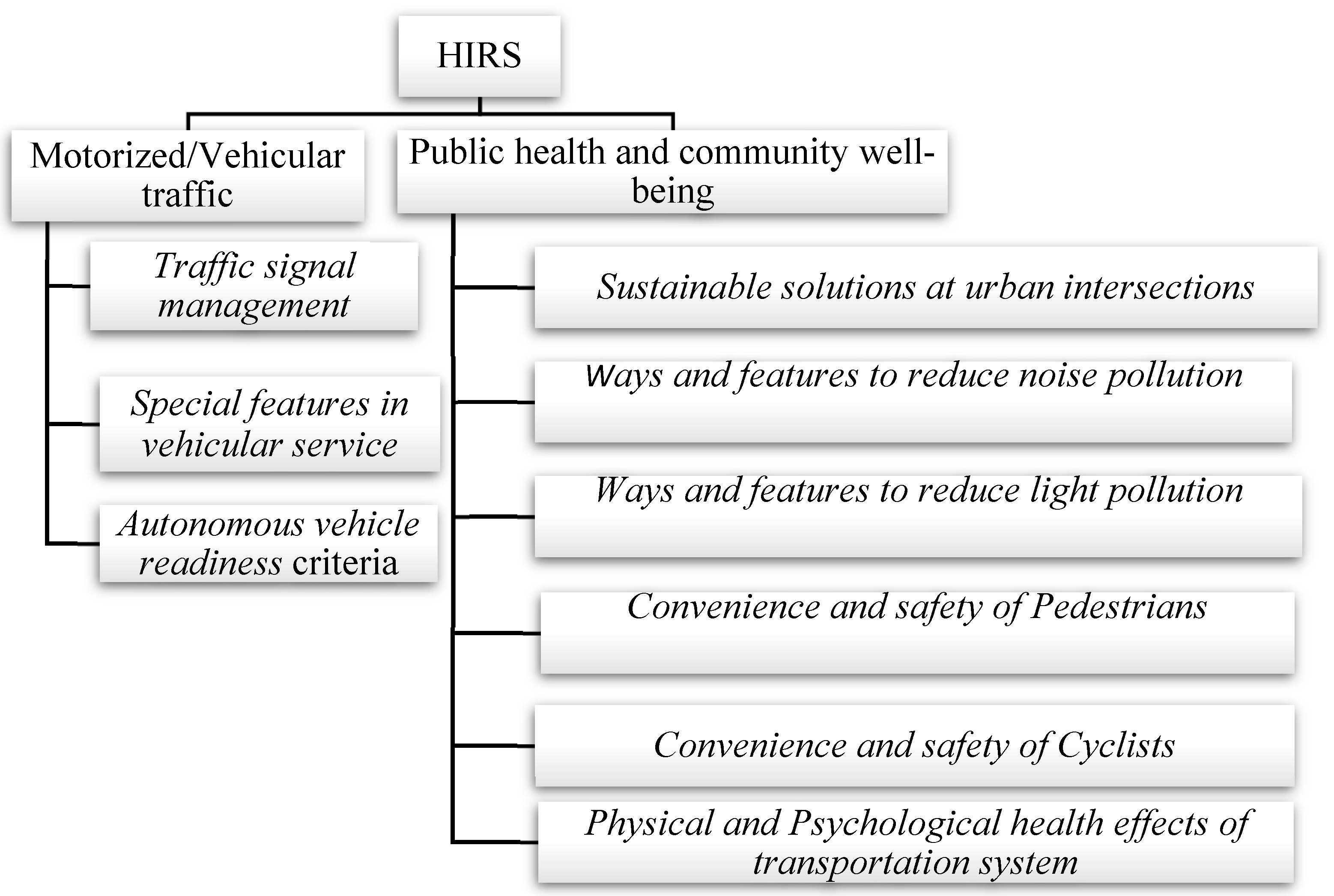
- It explicitly acknowledges the importance of public health and community wellbeing in the design and operations of signalized intersections. It incorporates and weights pertinent features that effectively act as “pathways” to health and community wellbeing. In previous rating systems, such features were missing or, at best, only implicitly considered. The case for HIRS follows from the notion that when seen from a holistic viewpoint, signalized urban intersections are integral components of an urban transportation system with direct and indirect links to public health and community wellbeing. It is no longer a luxury that we design and operate those intersections in isolation from the bigger context. In fact, the American Society of Civil Engineers (ASCE) code of ethics explicitly notes health and welfare. It states that “Engineers should take into consideration that the lives, safety, health and welfare of the general public are dependent upon engineering judgments, decisions and practices” [6]. Traditional health and welfare were thought of more as the domain of the public health profession. Not anymore. HIRS is at the heart of this transport–health nexus.
- It recognizes the worth of active modes of transportation (walking and cycling) and accords them due weight. Previous rating systems such as “performance evaluation of signalized urban intersections under mixed traffic conditions” focused on rating the performance of signalized urban intersections with respect to vehicular traffic [4]. As typical of most traditional rating systems, of which this study is one, a unimodal-centric approach treats pedestrian and cyclist traffic as “background, noise, or source of friction”. However, the transportation profession is changing in favor of a unified multi- or intermodal view of design and operations of transportation systems and their subsystems. Technological advances are both enabling and accelerating the change. Active modes of transportation are no longer part of the background. They are mainstream, and for good reasons: they reduce the number of auto trips and they have positive health benefits, not least of which are those resulting from the physical exercise that users perform during their transit between origins and destinations [7]. HIRS embodies this holistic view of all modes.
- It addresses two relatively new topics in urban transportation: the readiness of existing infrastructure to support autonomous vehicles (AV) and the effects of transportation systems on the mental health of users and residents of surrounding environs. HIRS aims to improve services that an intersection provides to users regardless of mode and level of technology penetration. Pedestrians, cyclists, and AVs are equally recognized and supported, consistent with the notion of creating complete streets [8,9]. HIRS also incorporates and rates features that affect the mental health of transportation system users and nearby residents. Subtle but significant issues of viability such as community severance and noise and light pollution have direct and indirect health impacts both on intersection users and nonuser nearby residents. HIRS captures and values the notion that a transportation system should not impede but, rather, facilitate the transit of users between points of interest while at the same time augmenting their experience through the promotion and enforcement of known positive health enablers (as physical designs, sound, and visual effects). Besides governmental agencies with traditional health-centric roles, now transportation units are increasingly seen as health-promoting agents; their traditional role of creating and maintaining the transportation system to support economic efficiency is now being augmented with promoting environmental sustainability, public health, and community character [8]. In the end, it is almost impossible to disconnect the notions of economic and environmental efficiency and technological advancement from social sustainability. The health of individuals and communities spans all those contemporary notions. HIRS is square at the intersection of all those conceptions.
1.4. Research Significance
1.5. Literature Review
2. Methods
2.1. Research Proposition
2.2. Research Methodology
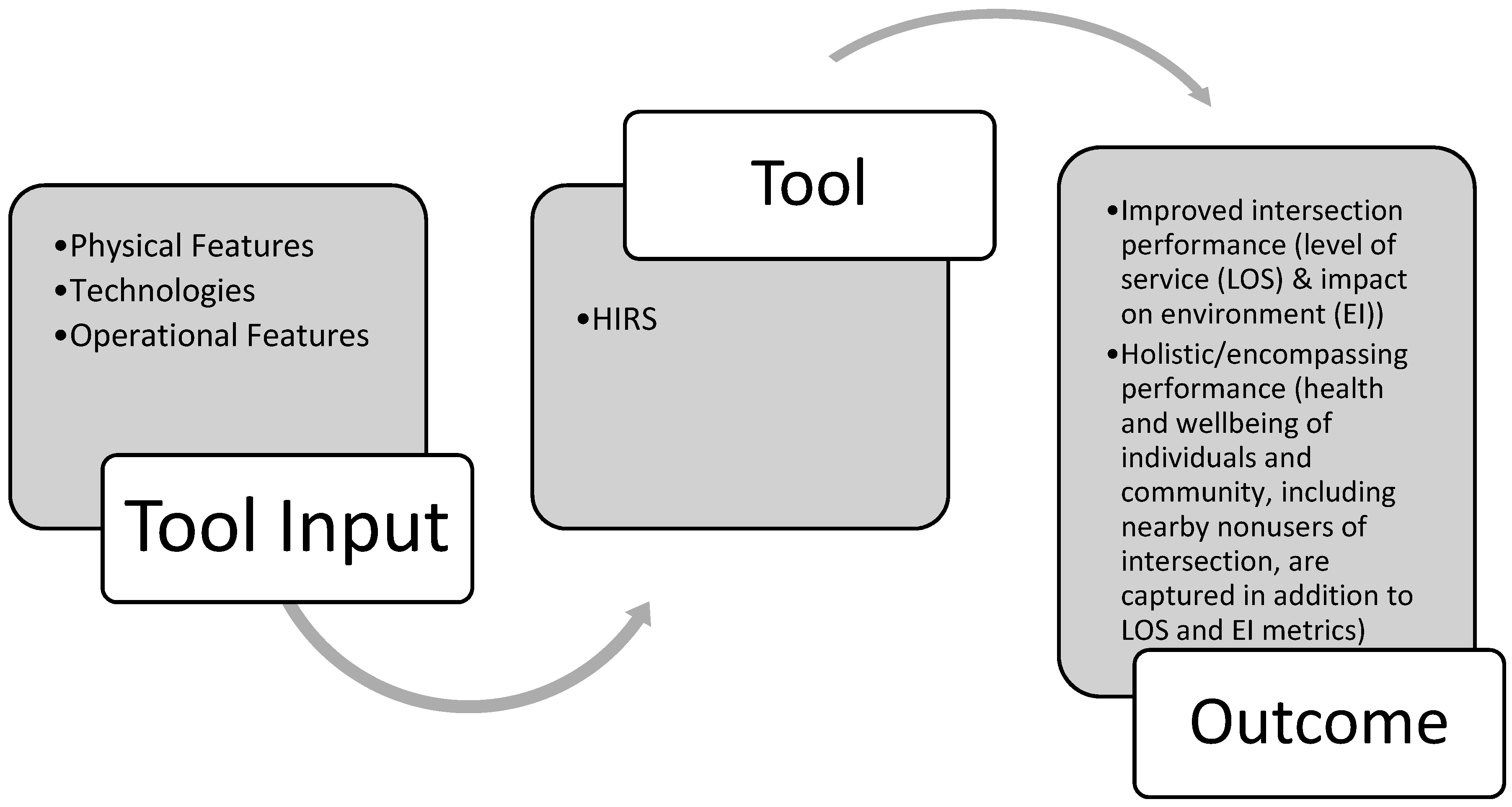
2.3. Brief Description of HIRS
2.3.1. Enabling Technologies
2.3.2. Physical Design Features
2.3.3. Operational Design Features
2.3.4. How to Use HIRS
2.4. Establishing the Relative Importance of HIRS Features (Items)
3. A Case Application of HIRS
4. Analysis of Results and Discussion
5. Conclusions
Author Contributions
Funding
Conflicts of Interest
Appendix A

| Holistic Intersection Rating System (HIRS) | ||||
|---|---|---|---|---|
| Section A: Motorized/vehicular traffic | ||||
| Subsection 1: Traffic signal management | ||||
| Subsection 1 Items: | Subsection description: | Points awarded based on: (1) | Weighted factor (2) | Score (1)*(2) |
| Item 1: Signal coordination | The three main parameters of traffic signal coordination, namely cycle length, split, and offset, are designed to allow the vehicle to cross multiple traffic signals on a section of the road [25]. | 1 point: The platoon of vehicles are able to cross multiple traffic signals on a section of a road in one go. 0 points: The platoon of vehicles are not able to cross multiple traffic signals on a section of a road in one go. | 0.83 | |
 | ||||
| Subsection 2: Special features | ||||
| Subsection 2 Items: | Subsection description: | Points awarded based on: (1) | Weighted factor (2) | Score (1)*(2) |
| Item 1: Flashing green light or a countdown timer | Flashing of a green light alerts the drivers that the pedestrian signal is activated; this procedure notifies the driver that the green light will end soon. | 1 point: Traffic signal has flashing green light. 0 points: Traffic signal does not have flashing green light. | 0.51 | |
 | ||||
| Section B: Public health and community wellbeing | ||||
| Subsection 1: Sustainable solutions at signalized urban intersections | ||||
| Subsection 1 Items | Subsection description: | Points awarded based on: (1) | Weighted factor (2) | Score (1)*(2) |
| Item 1: Usage of clean mode of power generation (for traffic lights and traffic signals) | Powering the traffic signals, electronic boards, and traffic lights with eco-friendly energy sources such as wind turbines and solar panels [44]. | 1 point: Usage of ecofriendly energy sources to power the traffic lights, traffic signals, and electronic boards. 0 points: Nonusage of ecofriendly energy sources to power the traffic lights, traffic signals, and electronic boards. 0 points: Absence of Item 1. | 0.66 | |
 | ||||
| Subsection 2: Ways and features to reduce noise pollution | ||||
| Subsection 2 Items: | Subsection description: | Points awarded based on: (1) | Weighted factor (2) | Score (1)*(2) Score (1)*(2) |
| Item 1: Absorption of the sound wave | Energy dissipater available on the side of the road (made up of wood, stucco, masonry, metal). | 1 point: Energy dissipater available on the side of the road (made up of wood, stucco, masonry, metal). 0 points: Energy dissipater not available on the side of the road (made up of wood, stucco, masonry, metal). | 0.54 | |
 | ||||
| Subsection 3: Ways and features to reduce light pollution | ||||
| Subsection 3 Items: | Subsection description: | Points awarded based on: (1) | Weighted factor (2) | Score (1)*(2) Score (1)*(2) |
| Item 1: Turn off the lights when not needed | Traffic lights equipped with motion sensors to shut off the light when the intersection is totally empty (no pedestrians/vehicles/cyclists). | 1 point: Traffic lights equipped with motion sensors. 0 points: Traffic lights are not equipped with motion sensors. | 0.51 | |
 | ||||
| Subsection 4: Pedestrian service | ||||
| Subsection 4 Items: | Subsection description: | Points awarded based on: (1) | Weighted factor (2) | Score (1)*(2) Score (1)*(2) |
| Item 1: Median refuge island is wide enough to accommodate pedestrians and cyclists | The median refuge island is wide enough to accommodate pedestrians and cyclists. | 1 point: If the median refuge island is wide enough to accommodate the pedestrians. 0 points: If the median refuge island is not wide enough to accommodate the pedestrians. | 0.94 | |
 | ||||
| Subsection 5: Cyclist service | ||||
| Subsection 5 Items: | Subsection description: | Points awarded based on: (1) | Weighted factor (2) | Score (1)*(2) Score (1)*(2) |
| Item 1: Bicycle lanes | Lanes that are designated by solid white lines and a bicycle symbol that indicates that this lane is exclusively for bicycles. | 1 point: Presence of bicycle lane at the intersection. 0 points: Absence of bicycle lane at the intersection. | 0.94 | |
 | ||||
| Subsection 6: Psychological effect of transportation | ||||
| Subsection 6 Items: | Subsection description: | Points awarded based on: (1) | Weighted factor (2) | Score (1)*(2) Score (1)*(2) |
| Item 1: Components of biophilic design green street | The sides of the street of the intersection are planted. | 1 point: If the sides of the street of the intersection are planted. 0 points: If the sides of the street of the intersection are not planted. | 0.63 | |
 | ||||
| Total score = | ||||
References
- Leibowicz, B.D. Urban land use and transportation planning for climate change mitigation: A theoretical framework. Eur. J. Oper. Res. 2020, 284, 604–616. [Google Scholar] [CrossRef]
- May, A.D. Traffic Flow Fundamentals; Prentice Hall: Englewood Cliffs, NJ, USA, 1990. (In English) [Google Scholar]
- Federal Highway Administration. Signalized Intersections: Informational Guide. In Federal Highway Administration Research and Technology; Federal Highway Administration: Washington, DC, USA. Available online: https://www.fhwa.dot.gov/publications/research/safety/04091/03.cfm (accessed on 12 October 2019).
- Yue, Z.Q.; Wong, S.C. Performance evaluation of signalized urban intersections under mixed traffic conditions by gray system theory. J. Transp. Eng. 2004, 130, 113–121. [Google Scholar]
- Office, G.B.N.A. Improving Road Safety for Pedestrians and Cyclists in Great Britain: Department for Transport; Stationery Office: London, UK, 2009; (HC. 2008-09; 437). (In English) [Google Scholar]
- American Society of Civil Engineers. Code of Ethics; American Society of Civil Engineers: Washington, DC, USA, 2019. Available online: https://www.asce.org/code-of-ethics/ (accessed on 16 May 2019).
- Ghassan, A.-L. Urban transport and impacts on public health. In Low Carbon Mobility for Future Cities: Principles and Applications; The Institution of Engineering and Technology: London, UK, 2017. [Google Scholar] [CrossRef]
- Meyer, M.D.; Elrahman, O.A. Transportation and Public Health: An Integrated Approach to Policy, Planning, and Implementation; Elsevier: Amsterdam, The Netherlands, 2019. (In English) [Google Scholar]
- Simpson, S.; Ozbek, M.; Clevenger, C.; Atadero, R. A Framework for Assessing Transportation Sustainability Rating Systems for Implementation in US State Departments of Transportation; Mountain Plains Consortium: Fargo, ND, USA, 2014. [Google Scholar]
- Clark, C.P.M.H.; Tetreault, Z.; Thomas, J. Green Guide for Roads Rating System; Worcester Polytechnical Institute: Worcester, UK, 2009; Available online: https://web.wpi.edu/Images/CMS/CEE/Green_Guide_for_Roads_Rating_System.pdf (accessed on 12 October 2019).
- Illinois State Department of Transportation. American Council of Engineering Companies of, A. Illinois Road and Transportation Builders, and G. Illinois Joint Sustainability. In I-LAST: Illinois-Livable and Sustainable Transportation Rating System and Guide; Illinois State Department of Transportation, Division of highways: Springfield, IL, USA, 2012. (In English) [Google Scholar]
- Weinstein, N. An Interactive Conference on the State of the Art and How to Achieve Sustainable Outcomes. In Proceedings of the Green Streets and Highways 2010, Denver, CO, USA, 14–17 November 2010; American Society of Civil Engineers: Denver, CO, USA, 2011. (In English). [Google Scholar]
- Foundation, G. What Is Greenroads; Greenroads Foundation: Seattle, WA, USA, 2020; Available online: http://www.greenroads.org/howitworks (accessed on 6 May 2019).
- Lee, J.C.; Edil, T.B.; Benson, C.H.; Tinjum, J.M. Evaluation of variables affecting sustainable highway design with BE2ST-in-Highways system. Transp. Res. Rec. 2011, 2233, 178–186. [Google Scholar] [CrossRef]
- Lee, J.; Tinjum, J.M.; Edil, T.B.; Benson, C.H. Building Environmentally and Economically Sustainable Transportation Infrastructure: Green Highway Rating System. J. Constr. Eng. Manag. 2013, 139. [Google Scholar] [CrossRef]
- McVoy, G.; Nelson, D.A.; Krekeler, P.; Kolb, E.; Gritsavage, J.S. Moving towards Sustainability: New York State Department of Transportation’s GreenLITES Story. In Proceedings of the Green Streets and Highways 2010: An Interactive Conference on the State of the Art and How to Achieve Sustainable Outcomes, Denver, CO, USA, 14–17 November 2010; American Society of Civil Engineers: Denver, CO, USA, 2010. [Google Scholar]
- FHWA. About Invest; Federal Highway Administration: Washington, DC, USA, 2018. Available online: https://www.sustainablehighways.org/100/about.html (accessed on 3 May 2019).
- CEEQUAL. An Introduction to CEEQUAL; CEEQUAL: Watford, UK, 2010; Available online: http://www.ceequal.com/about/ (accessed on 12 October 2019).
- Santa Cruz County Regional Transportation Commission. Sustainable Transportation Access Rating System (STARS); Santa Cruz County Regional Transportation Commission: Santa Cruz, CA, USA, 2020. Available online: https://sccrtc.org/projects/multi-modal/stars/ (accessed on 14 May 2019).
- Institution for Sustainable Infrastructure. Envision’s Critical Role in Infrastructure Sustainability; Institution for Sustainable Infrastructure: Washington, DC, USA; Available online: https://sustainableinfrastructure.org/envision/use-envision/ (accessed on 15 May 2019).
- Kazmierowski, T.; Navarra, M. Sustainability Metrics of Two Pavement Rating Systems Developed in Canada. Green Technol. 2014, 1, 1–17. Available online: http://conf.tac-atc.ca/english/annualconference/tac2014/s-22/kazmierowski.pdf (accessed on 23 May 2019).
- Pratt, D.; Santi, P.; Mountain, G.-C.R. A landslide hazard rating system for Colorado highways. Geotech. Pract. Publ. 2014, 2014, 120–138. [Google Scholar]
- Strickland, J.A.; Wiltshire, R.L.; Goss, C.M. Front Matter. In Proceedings of the Rocky Mountain Geo-Conference 2014, Lakewood, CO, USA, 7 November 2014. [Google Scholar]
- Yun, I.; Park, B. Stochastic Optimization for Coordinated Actuated Traffic Signal Systems. J. Transp. Eng. 2012, 138, 819. [Google Scholar] [CrossRef]
- Köhler, E.; Strehler, M. Traffic Signal Optimization: Combining Static and Dynamic Models. Transp. Sci. 2019, 53, 21. [Google Scholar] [CrossRef] [Green Version]
- Truong, L.T.; Currie, G.; Sarvi, M. Analytical and simulation approaches to understand combined effects of transit signal priority and road-space priority measures. Transp. Res. Part C 2017, 74, 275–294. [Google Scholar] [CrossRef]
- Ko, M.; Geedipally, S.R.; Walden, T.D.; Wunderlich, R.C. Effects of red light running camera systems installation and then deactivation on intersection safety. J. Saf. Res. 2017, 62, 117. [Google Scholar] [CrossRef]
- Gandy, R.; Meitner, M.J. Advanced traveler information systems: Bringing environmental information to recreational driving. Landsc. Urban Plan. 2008, 85, 185–194. [Google Scholar] [CrossRef]
- Ma, J.; Lochrane, T.; Jodoin, P. Traffic Incident Management Programs AND Benefit-Cost Analysis. Inst. Transp. Eng. ITE J. 2016, 86, 30–36. [Google Scholar]
- Ziou, D.; Kerouh, F. Estimation of light source colours for light pollution assessment. Environ. Pollut. 2018, 236, 844–849. [Google Scholar] [CrossRef] [PubMed]
- World Health Organization; Foundation for the Automobile and Society; Global Road Safety Partnership; World Bank. Pedestrian Safety: A Road Safety Manual for Decision-Makers and Practitioners; World Health Organization: Geneva, Switzerland, 2013. (In English) [Google Scholar]
- Council, B.C. Guidelines for Audio-Tactile Pedestrian Facilities; Brisbane City Council: Brisbane, QLD, Australia, 2019. Available online: https://www.brisbane.qld.gov.au/traffic-transport/traffic-management/audio-tactile-pedestrian-facilities (accessed on 23 May 2019).
- National Association of City Transportation Officials. Urban Bikeway Design Guide; National Association of City Transportation Officials: New York, NY, USA, 2014. (In English) [Google Scholar]
- Stamatiadis, N.; Kirk, A.; Hartman, D.; Pigman, J. A Process for Measuring Context Sensitive Solutions Benefits. In Proceedings of the Green Streets and Highways 2010: An Interactive Conference on the State of the Art and How to Achieve Sustainable Outcomes, Denver, CO, USA, 14–17 November 2010; American Society of Civil Engineers: Denver, CO, USA, 2010. [Google Scholar]
- Afrad, A.; Kawazoe, Y. Can interaction with informal urban green space reduce depression levels? An analysis of potted street gardens in Tangier, Morocco. Public Health 2020, 186, 83–86. [Google Scholar] [CrossRef] [PubMed]
- Beatley, T. Biophilic Cities and Healthy Societies. Urban Plan. 2017, 2, 1–4. [Google Scholar] [CrossRef] [Green Version]
- Frumkin, H.; Fox, J. Contact with Nature. In Making Healthy Places: Designing and Building for Health, Well-Being, and Sustainability; Island Press/Center for Resource Economics: Washington, DC, USA, 2011; pp. 229–243. [Google Scholar]
- Silvestre, B.S.; Ţîrcă, D.M. Innovations for sustainable development: Moving toward a sustainable future. J. Clean. Prod. 2019, 208, 325–332. [Google Scholar] [CrossRef]
- Factor, R.; Prashker, J.N.; Mahalel, D. The flashing green light paradox. Transp. Res. Part F Psychol. Behav. 2012, 15, 279–288. [Google Scholar] [CrossRef]
- Yu, S.; Shi, Z. Analysis of car-following behaviors considering the green signal countdown device. Nonlinear Dyn. 2015, 82, 731–740. [Google Scholar] [CrossRef]
- Transport of London. Yellow Box Junctions; Transport of London: London, UK. Available online: https://tfl.gov.uk/modes/driving/red-routes/rules-of-red-routes/yellow-box-junctions (accessed on 25 June 2019).
- Zhao, M.; Sharma, A.; Smaglik, E.; Overman, T. Traffic Signal Battery Backup Systems: Use of Event-Based Traffic Controller Logs in Performance-Based Investment Programming. Transp. Res. Rec. 2015, 2488, 53–61. [Google Scholar] [CrossRef]
- Bai, X.F.; Cai, H.N.; Qiu, S.; Li, P.; Na Song, X. Solar Energy Traffic Control Box Design. Appl. Mech. Mater. 2014, 538, 398–401. [Google Scholar] [CrossRef]
- World Health Organization Regional Office for Europe. Night Noise Guidelines for Europe; World Health Organization: Geneva, Switzerland, 2009. (In English) [Google Scholar]
- Lacasta, A.M.; Peñaranda, A.; Cantalapiedra, I.R. Green Streets for Noise Reduction. In Nature Based Strategies for Urban and Building Sustainability; Elsevier: Amsterdam, The Netherlands, 2018; pp. 181–190. [Google Scholar]
- Thomas, L.; Thirsk, N.J.; Zegeer, C.V. Application of Pedestrian Crossing Treatments for Streets and Highways; Transportation Research Board: Washington, DC, USA, 2016; (NCHRP synthesis, 0547-5570; no. 498). (In English) [Google Scholar]
- Tomomi, M. Installation errors and corrections in tactile ground surface indicators in Europe, America, Oceania and Asia. IATSS Res. 2008, 32, 68–80. [Google Scholar] [CrossRef]
- Kim, M.; Hong, S.-h. Relationship between the reflected brightness of artificial lighting and land-use types: A case study of the University of Arizona campus. Landsc. Ecol. Eng. 2015, 11, 39–45. [Google Scholar] [CrossRef]
- Downes, S. Look Out for Smiley Faces when You’re Driving on This UAE Road. Available online: http://whatson.ae/dubai/2017/08/look-smiley-faces-uae-roads/ (accessed on 6 June 2019).
- New Dubai Traffic Signs Use Emojis. Gulf News: Dubai, United Arab Emirates, 2017. Available online: https://gulfnews.com/uae/transport/new-dubai-traffic-signs-use-emojis-1.2090806 (accessed on 3 May 2019).
- Sun, B.; Deng, W.; Wu, J.; Li, Y.; Wang, J. An Intention-aware and Online Driving Style Estimation Based Personalized Autonomous Driving Strategy. Int. J. Automot. Technol. 2020, 21, 1431–1446. [Google Scholar] [CrossRef]
- Kockelman, K. An Assessment of Autonomous Vehicles: Traffic Impacts and Infrastructure Needs—Final Report; CTR Technical Report; 0-6847-1; Center for Transportation Research, The University of Texas at Austin: Austin, TX, USA, 2017. (In English) [Google Scholar]
- Meng, X.; Roberts, S.; Cui, Y.; Gao, Y.; Chen, Q.; Xu, C.; He, Q.; Sharples, S.; Bhatia, P. Required navigation performance for connected and autonomous vehicles: Where are we now and where are we going? Transp. Plan. Technol. 2018, 41, 104–118. [Google Scholar] [CrossRef]
- Pedestrian Bicycle Information Center. Pedestrian and Bicyclist Crash Statistics; U.S. Department of Transportation Federal Highway Administration: Raleigh, NC, USA, 2018. Available online: http://www.pedbikeinfo.org/data/factsheet_crash.cfm#No1 (accessed on 20 May 2019).


| Final score = 0–6.25 (Percent final score: 0–20%) Very low level of usage of technologies and physical design and operational features | Final score = 6.25–12.5 (Percent final score: 20–40%) Low level of usage of technologies and physical design and operational features | Final score = 12.5–18.75 (Percent final score: 40–60%) Moderate level of usage of technologies and physical design and operational features | Final score = 18.75–25 (Percent final score: 60–80%) High level of usage of technologies and physical design and operational features | Final score = 25–31.25 (Percent final score: 80–100%) Very high level of usage of technologies and physical design and operational features |
| HIRS 44 Items | Extremely Important | Very Important | Important | Somewhat Important | Not at All Important |
|---|---|---|---|---|---|
| Item 1: Signal coordination | 2 | 4 | 1 | ||
| Item 2: Dynamic signal optimization | 4 | 2 | 1 | ||
| Item 43: Use of creative signs that have humor/emotions/emojis | 2 | 2 | 3 | ||
| Item 44: Context sensitivity | 2 | 4 | 1 |
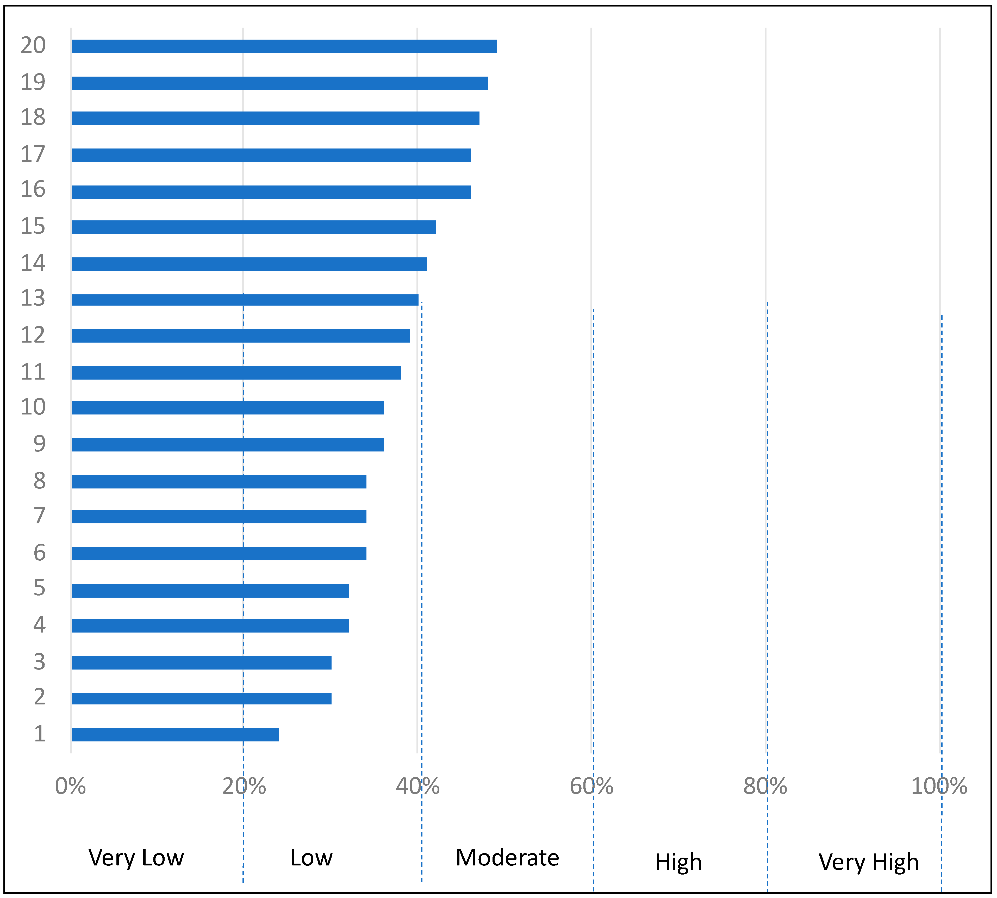
| Signalized Urban Intersection No. | Final Score out of 31.2 Points | Final Score, Percent | Level of Usage of Technologies and Physical Design and Operational Features |
|---|---|---|---|
| 1 | 15.35 | 49% | Moderate |
| 2 | 14.38 | 46% | Moderate |
| 3 | 14.56 | 47% | Moderate |
| 4 | 14.42 | 46% | Moderate |
| 5 | 15.07 | 48% | Moderate |
| 6 | 12.47 | 40% | Moderate |
| 7 | 12.12 | 39% | Low |
| 8 | 11.81 | 38% | Low |
| 9 | 12.67 | 41% | Moderate |
| 10 | 10.03 | 32% | Low |
| 11 | 11.32 | 36% | Low |
| 12 | 10.51 | 34% | Low |
| 13 | 7.57 | 24% | Low |
| 14 | 11.32 | 36% | Low |
| 15 | 13.16 | 42% | Moderate |
| 16 | 10.64 | 34% | Low |
| 17 | 10.52 | 34% | Low |
| 18 | 10.09 | 32% | Low |
| 19 | 9.36 | 30% | Low |
| 20 | 9.49 | 30% | Low |
| Tested Signalized Urban Intersections’ Holistic Operational Performance | ||
|---|---|---|
| Statistical Measures | Final Score (out of 31.25) | Percent Final Scores |
| Mean (avg.) final score | 11.84 | 38% |
| Maximum final score | 15.35 | 49% |
| Minimum final score | 7.57 | 24% |
| Standard deviation Final score | 2.15 | − |
Publisher’s Note: MDPI stays neutral with regard to jurisdictional claims in published maps and institutional affiliations. |
© 2021 by the authors. Licensee MDPI, Basel, Switzerland. This article is an open access article distributed under the terms and conditions of the Creative Commons Attribution (CC BY) license (https://creativecommons.org/licenses/by/4.0/).
Share and Cite
Saba, W.E.; Beheiry, S.M.; Abu-Lebdeh, G.; AL-Tekreeti, M.S. A Holistic Intersection Rating System (HIRS)—A Novel Methodology to Measure the Holistic Operational Performance of Signalized Urban Intersections. Smart Cities 2021, 4, 1018-1038. https://0-doi-org.brum.beds.ac.uk/10.3390/smartcities4030054
Saba WE, Beheiry SM, Abu-Lebdeh G, AL-Tekreeti MS. A Holistic Intersection Rating System (HIRS)—A Novel Methodology to Measure the Holistic Operational Performance of Signalized Urban Intersections. Smart Cities. 2021; 4(3):1018-1038. https://0-doi-org.brum.beds.ac.uk/10.3390/smartcities4030054
Chicago/Turabian StyleSaba, Wesam Emad, Salwa M. Beheiry, Ghassan Abu-Lebdeh, and Mustafa S. AL-Tekreeti. 2021. "A Holistic Intersection Rating System (HIRS)—A Novel Methodology to Measure the Holistic Operational Performance of Signalized Urban Intersections" Smart Cities 4, no. 3: 1018-1038. https://0-doi-org.brum.beds.ac.uk/10.3390/smartcities4030054