1. Introduction
The widespread marine geophysical techniques allow for obtaining new datasets for underwater sea-floor feature detection. Many of these techniques were used to perform a marine survey requested by the Government Commissioner for the remediation of the Taranto area and performed by Università degli Studi di Bari Aldo Moro, Politecnico di Bari, Centro Nazionale delle Ricerche, Consorzio Nazionale Interuniversitario delle Scienze del Mare, particularly focusing on the Mar Piccolo and Mar Grande basins (Taranto, Southern Italy), in an area considered a SIN–Sito di Interesse Nazionale (Site of National Interest) due to its pollution degree. In the Taranto area, a detailed study of the sea-bottom was performed by means of geophysical surveys, aimed at the characterization of the geological and morphological features of the Mar Piccolo basin [
1,
2,
3,
4], to plan intervention strategies for environmental remediation [
5,
6,
7,
8].
Planning of environmental remediation strategies requires an accurate geophysical survey, especially in shallow water and in highly anthropogenic areas (e.g., [
9,
10]) where it is not always trivial to distinguish natural elements from anthropogenic ones [
10].
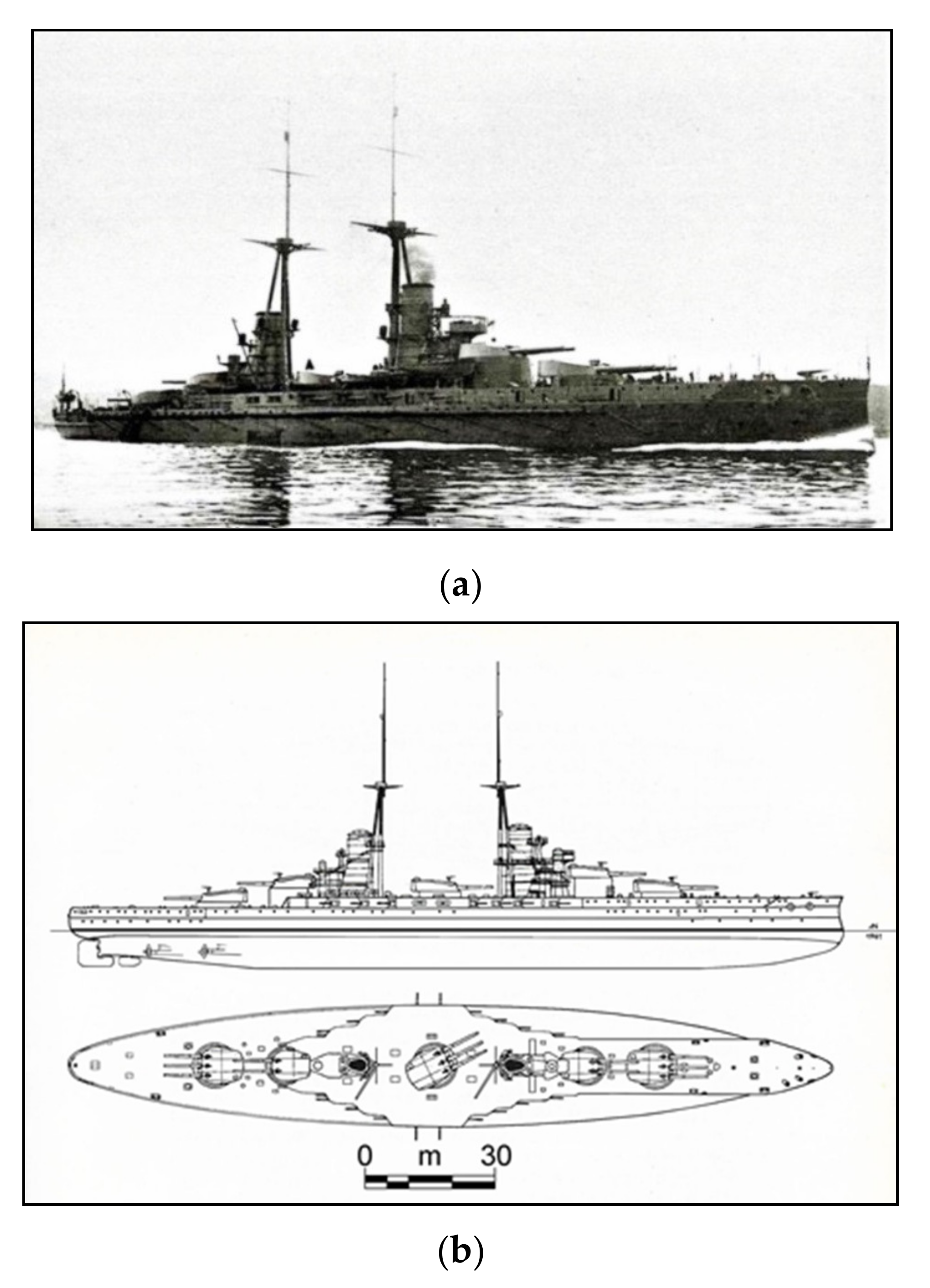
A new dataset acquired in the Mar Piccolo basin by means of multibeam echosounder system (MBES), side scan sonar (SSS), parametric sub-bottom profiler (SBP), and cesium vapor magnetometer surveys, highlighting the natural sea-floor features and the anthropogenic footprints on the sea-bottom. Such sea-floor features were identified and classified in order to determine their anthropogenic or natural origin. Among the anthropogenic features, the footprint of the battleship Leonardo Da Vinci of the Italian Royal Navy (“Regia Marina”) was discovered (
Figure 1). The battleship sank on the night of 2 August 1916 [
11], and the removal of the shipwreck determined several environmental and management issues for the "cultural heritage” [
12,
13,
14,
15], recording an inauspicious event that happened on the Mar Piccolo sea-bottom.
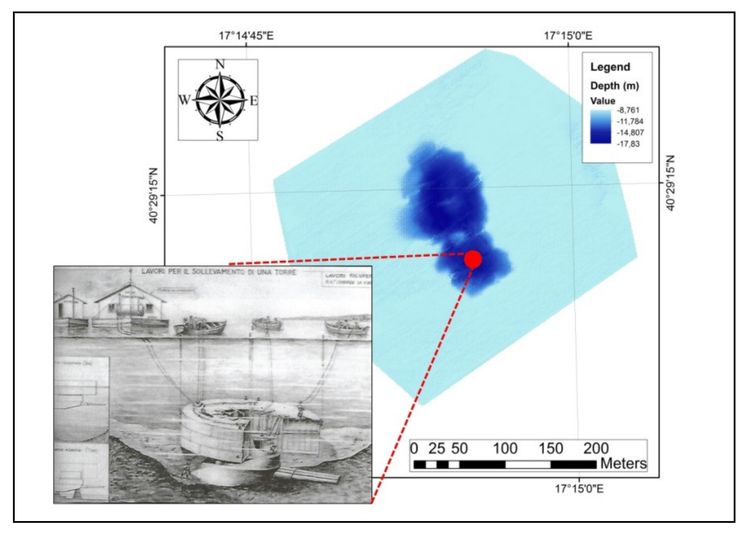
The position of the capsized hull of the Leonardo Da Vinci (
Figure 2), reported in the historical documents [
17,
18], matches a sub-circular depression position detected on the sea-bottom, traditionally reported as “Lost Citro”. “Citro” is a local term used to indicate a submarine karst spring with a freshwater outflow. A detailed survey of the “Citri” in the Mar Piccolo was performed by Valenzano et al. [
3], showing similar shapes of natural origin.
Geophysical data analysis allowed correcting the first misinterpreted assessment on the origin of such features and finally highlighting the impact of the battleship Leonardo Da Vinci on the sea-bottom. At first, the “Lost Citro” depression was interpreted as ”Citro”-like features even without any historically reported water flows but, finally, it was related to the battleship Leonardo Da Vinci wreckage.
Impact of the Wreckages for the Sea-Floor Integrity
The presence of historical wreckages on the seabed determines an element of perturbation for the sea-floor integrity, considering that they may cause significant changes to the ecological systems and the morphological conditions. The impact of historical wreckages could cause the occurrence of uncontrolled oil spilling [
12] and a perturbation on the sea-floor morphodynamic [
8,
20]. The operations for wreckages recovery could determine two types of seabed impacts: a direct impact if human interventions actively modified the seabed morphology, or an indirect impact if new seabed morphologies show new changes due to the reaction of the ecological and sedimentary processes [
9]. An example of anthropogenic footprints connected to direct human impacts was reported in the Venice Lagoon (Northern Italy), where an accurate study was performed through a multibeam survey in order to raise the awareness of stakeholders, decision makers, and the general public on the hidden anthropogenic imprints [
9], detecting dredged areas and erosional sea-floor features produced by ship keels.
An indirect impact on the seabed was observed with the collision of the cruise vessel Costa Concordia on 13 January 2012, just off the eastern shore of Giglio Island in the Tyrrhenian Sea (Tuscany, Italy) [
14]. Its sinking occurred onto a seabed characterized by two monzogranite rocky ridges surrounded by sandy sediments. The recovery of the cruise vessel Costa Concordia in July 2014 (Tuscany, Italy) determined fine sediment dispersion and debris diffusion due to parbuckling and subsequent wreck refloating, which caused a decreasing quality of the coralligenous habitats [
14].
After World War II, a lot of chemical weapons of the battleships were disposed and sunk to the sea-bottom. An example is reported on the off-shore seabed in Norway [
21], where the project EU-DAIMON (Decision Aid for Marine Munitions) was performed to detect dumped sites and chemical weapons of German battleships through multibeam and side scan sonar surveys.
Among the different works for the wreck recovery, the employment of marine geophysical surveys was a fundamental step in order to plan the sustainable interventions, such as avoiding an oil spill occurrence [
15,
20], or for the characterization of morphological changes [
10,
22,
23].
2. The Mar Piccolo
The Taranto area (Southern Italy) is located on the northern Ionian coast, between the south-western sector of the Apulian Foreland and the eastern Bradanic Foredeep. The stratigraphic succession of the Mar Piccolo basin is represented, from the bottom, by Mesozoic limestone (Calcare di Altamura Fm); they are covered in transgression by the Upper Pliocene–Lower Pleistocene calcarenite (Calcarenite di Gravina Fm) and by the interfingered argille subappennine informal units. Both are covered by sediments ascribed to the marine deposits of the Upper Pleistocene age [
2,
24,
25,
26]. The Taranto landscape is characterized by a sequence of quasi-flat surfaces consisting of marine terraces crossed by a fluvial network, marked by a rectangular pattern and by three sub-circular basins, called Mar Grande and Mar Piccolo, literally “Big Sea” and “Little Sea” [
2,
27]. The Punta Penna promontory divides the Mar Piccolo basin into two smaller embayments, called Primo Seno and Secondo Seno, determining the eight-shape plan morphotopography (
Figure 3).
The Mar Piccolo is a small, protected marine basin which originated from a river valley flooded by the Holocene transgression and enlarged by the sea wave effects with a current configuration of a rias [
3,
27,
28]. It extends for about 20 km
2, located north of the city of Taranto and it is connected with the Mar Grande by two channels; the north-western one is a natural one (Canale di Porta Napoli), while the eastern one (Canale Navigabile) was excavated artificially through the Pleistocene calcarenite in the late XIX century, when the Italian Government decided to realize the Mar Piccolo as the biggest shipyard of the Italian Royal Navy [
28,
29]. The maximum water depth (wd) of the Mar Piccolo sea-bottom is about 15 m, with some deeper tight depressions (up to a 33 m wd). These latter correspond to the sub-circular submarine springs, known locally as “Citri” [
30,
31,
32,
33].
The “Citri” are characterized by a deep and steep inverted cone surface and by a high groundwater velocity determining an outflow visible on the seawater surface [
34,
35,
36,
37]. Freshwater outflow comes from a karst aquifer developed into the Mesozoic limestone, confined by a cover of Middle-Upper Pleistocene clays and in some cases by Calcarenite di Gravina Fm (Pliocene–Lower Pleistocene) [
31,
32,
33].
3. The Battleship Leonardo Da Vinci
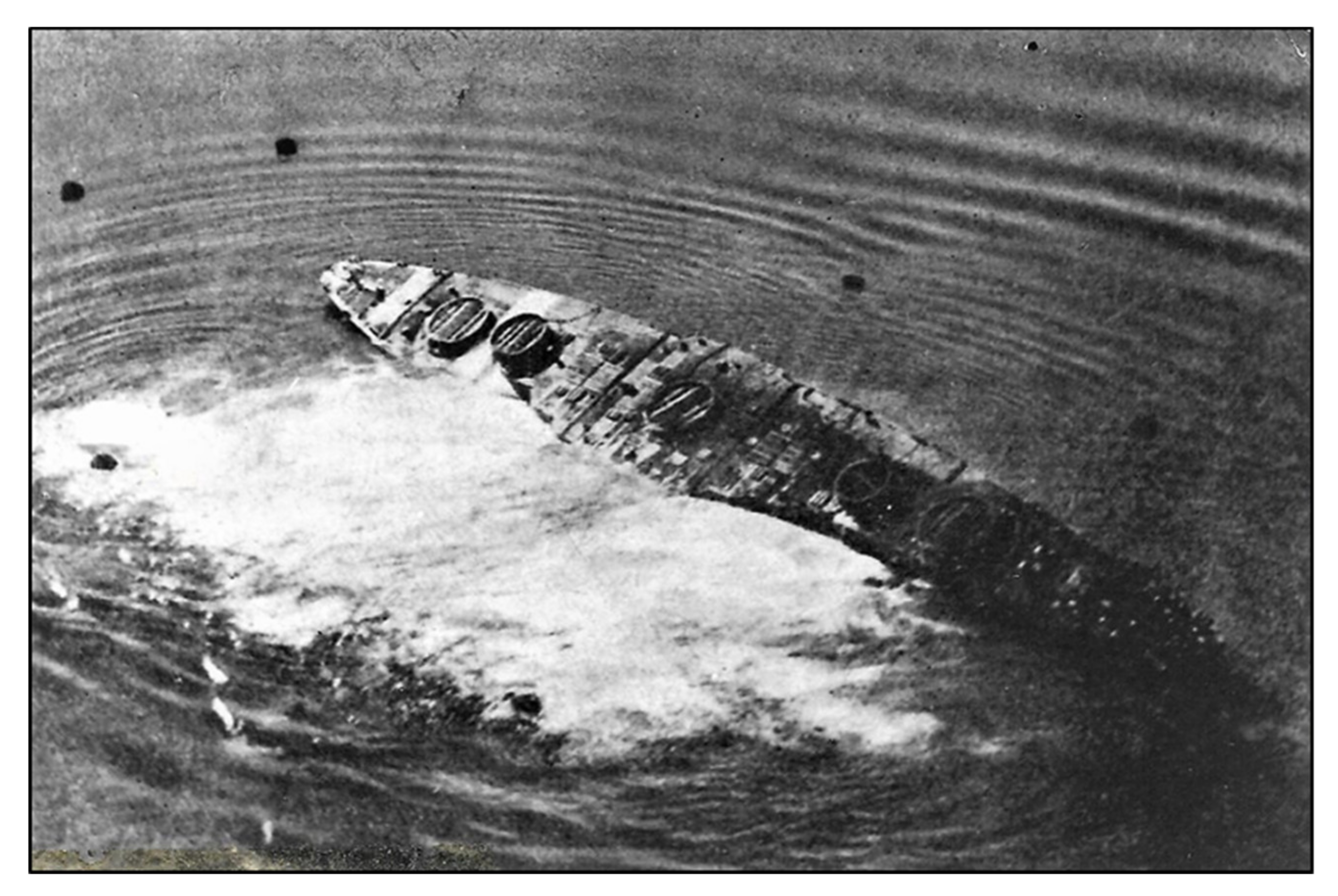
During the First World War (WWI), Italian, French, and English warships frequently stood by in the Mar Grande and the Primo Seno of the Mar Piccolo basin. As other Italian Royal Navy capital ships, the Leonardo Da Vinci battleship had its homeport in Taranto. The Leonardo Da Vinci was a modern dreadnought, launched in 1911, of about 25000 tons (full load) displacement, 168.9 m in length, protected by up to 250 mm steel, armed by 13 guns of 305/46 (and others minor), powered by 31,000 HP and capable of about 22 knots maximum speed; its heart was represented by about 1000 sailors (
Figure 1).
During the night of 2 August 1916, it was anchored at about the Primo Seno of Mar Piccolo center with eight other warships, ready to prevent the Austrian fleet from leaving the Adriatic Sea via the Otranto Channel and to defend the merchant shipping operations [
11,
17]. Documents of the Ministry of the Italian Navy [
38] report that during the night of 2 August 1916, there was a violent explosion which determined the Leonardo Da Vinci as tilted up to 165°, which finally capsized and rapidly sunk, determining 249 casualties including the commander, CV Sommi Picenardi.
The explosion was caused by fires of unknown origin, probably due to sabotage acted by the Austrian Empire intelligence agents in the stern area near the Santa Barbara of tower n.5, at 23:00 local time of 2 August 1916. At 23:10, the violent and devastating Santa Barbara outbreak broke up the aft tower, which was projected over 150 m away from the battleship with the superstructures and part of the bridge deck. The commander ordered to abandon the battleship and the survivors were recovered by the other warships present in the Mar Piccolo basin. At 23:15, the Leonardo Da Vinci began to take on water from the leak caused by the explosions and it rapidly reversed and sank.
Moreover, the Leonardo Da Vinci explosions generated a big seismic wave that was recorded by the seismograph Vicentini in the Geophysical Institute of Meteorological and Geophysical Observatory "L. Ferrajolo” of Taranto [
39]. As a consequence of the explosions and sinking, a big sea wave was generated, reported as a “night tsunami during the First World War”, flooding the low-lying coasts of Primo Seno and the Old Town streets close to the coastline [
19].
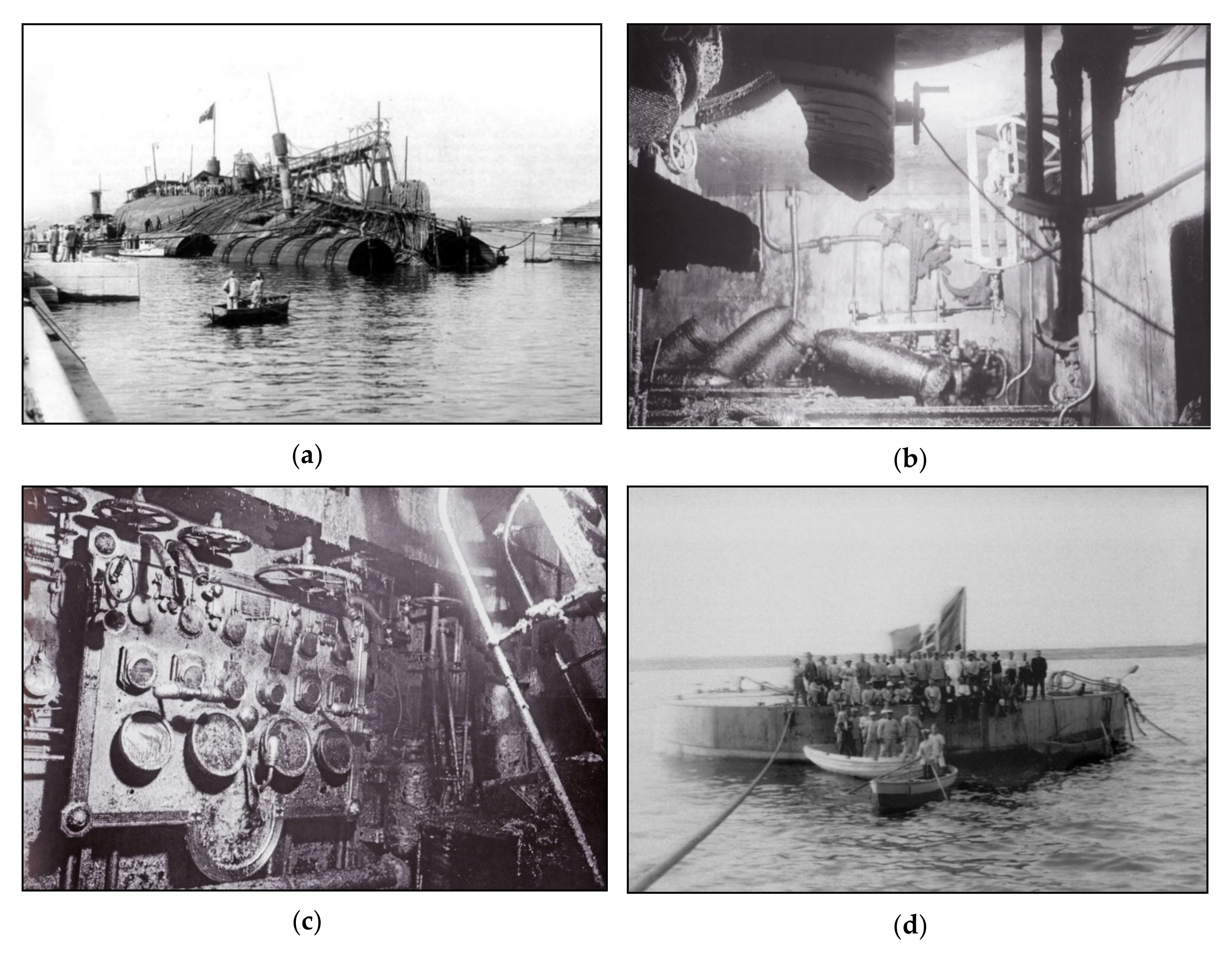
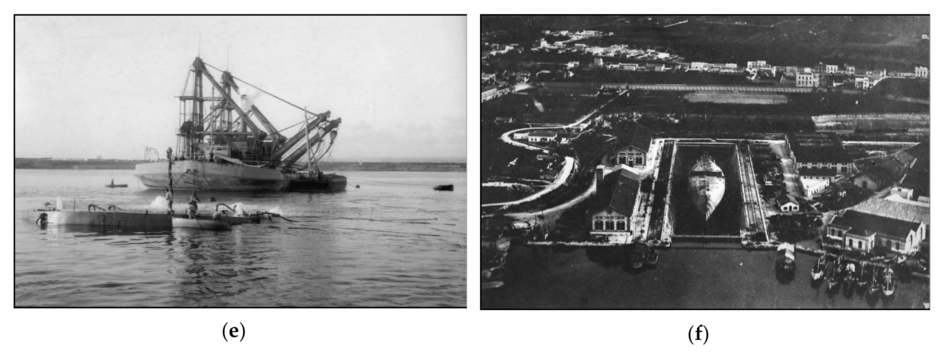
In October 1916, a floating site was set up around the dreadnought, consisting of the support vessel Anteo, two barges as the workers’ and technicians’ accommodation, and five pontoons with pumps and compressors to blow air into the wreck [
11]. The divers and technicians, led by the captain of the naval engineers, Armando Andri, worked for 30 months every day, decreasing the weight of the ship by about 6000 tons [
17,
18] (
Figure 4). Historical documents report details of the turrets removal operations [
17]: two ring-shaped tanks were built, attached to the bottom of the turrets; compressed air was pumped into the tanks allowing the turrets to float.
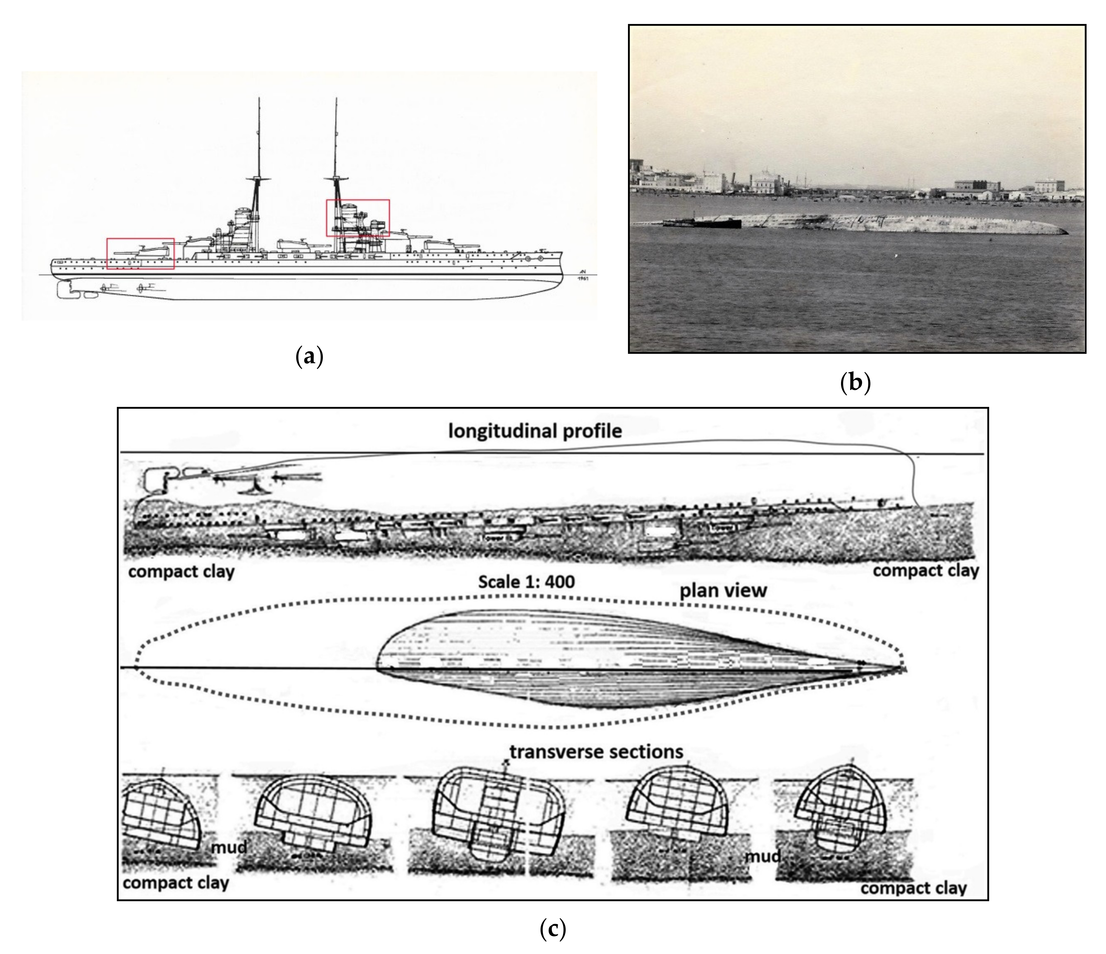
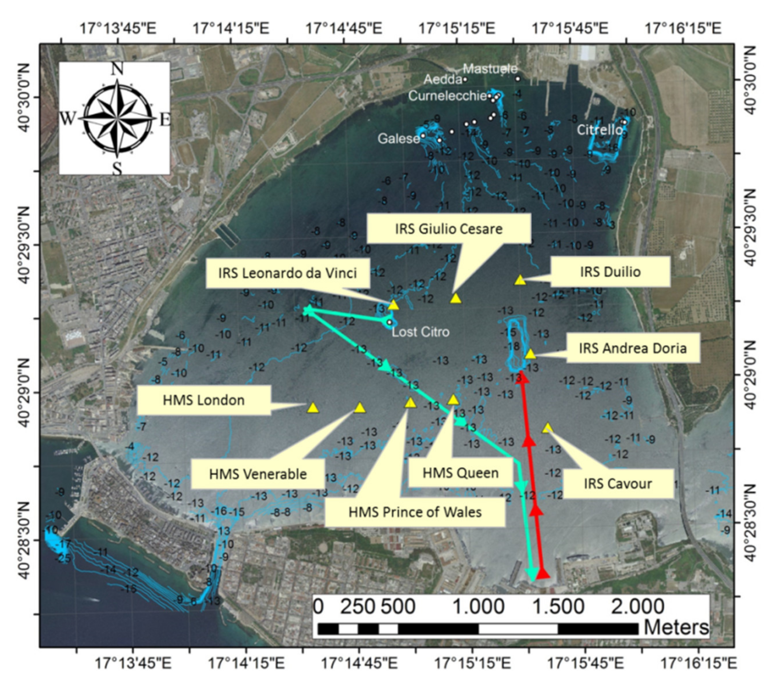
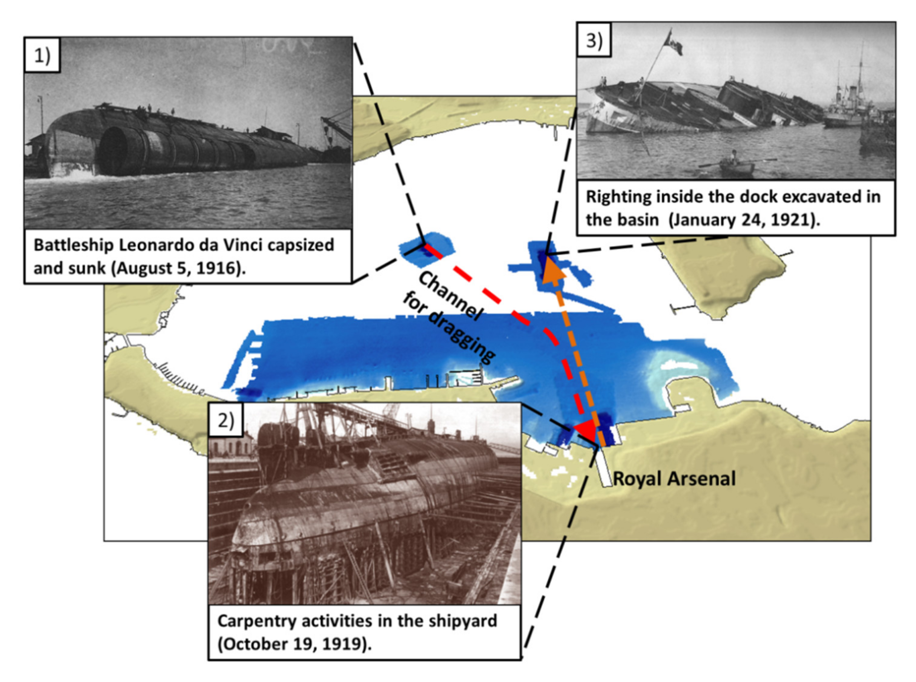
On 15 September 1919, the wreck was towed to a brickwork dock of the Royal Shipyard, digging a channel 2500 m long and 45 m wide, as reported in [
19] (
Figure 5, blue line). Towing activities were completed in the Royal Arsenal on 18 September 1919. On 6 October 1919, the dreadnought was dry-docked and, after the hull breaches repair, prepared for righting.
For the Leonardo Da Vinci righting activities, a special facility was created: about a 250 m long and 50 m wide trench was dredged on the sea-bottom on the 22 January 1921, at about 1300 m away from the Royal Arsenal dry dock (
Figure 5, red line), in order to allow a complete rotation of the vessel. The battleship was successfully righted on 24 January 1921 (
Figure 6).
4. Materials and Methods
In order to identify the sea-floor features of the Mar Piccolo of Taranto, a series of geophysical surveys was performed, by means of the multibeam echosounder system (MBES) R2Sonic 2022 and side scan sonar (SSS) Klein 3000, equipped on board the vessel “Issel”, owned by Consorzio Nazionale Interuniversitario per le Scienze del Mare (CoNISMa). Such methodologies allowed to produce a high-resolution morphobathymetry with centimetric resolution. In this way, it was possible to determine the occurrence of anthropogenic evidence connected to small wrecks, barrels, anchor scars, etc., in combination with a detailed mapping of submarine karst springs and the biological features on the sea-bottom.
The vessel positioning supplied by the real-time kinematic-global navigation satellite system (RTK-GNSS) receiver TRIMBLE SPS551 double frequency L1/L2, with correction supplied by UMTS Rete GPS Puglia via the NTRIP system. The position of the vessel was transmitted to the navigation PC equipped with the professional hydrographic data acquisition/navigation software TELEDYNE PDS 2000 during the field surveys.
MBES data were acquired using a beam open of 0.5° and a swath angle of 120°, at a depth accuracy of 10 cm, operating at selectable 200 and 400 kHz frequencies with a ping rate up to 30 Hz. SSS data were acquired using a swath width of 100 m (50% of overlap between adjacent lines) and attained at a 2 cm resolution across-track, with a frequency sampling range of 100–500 kHz.
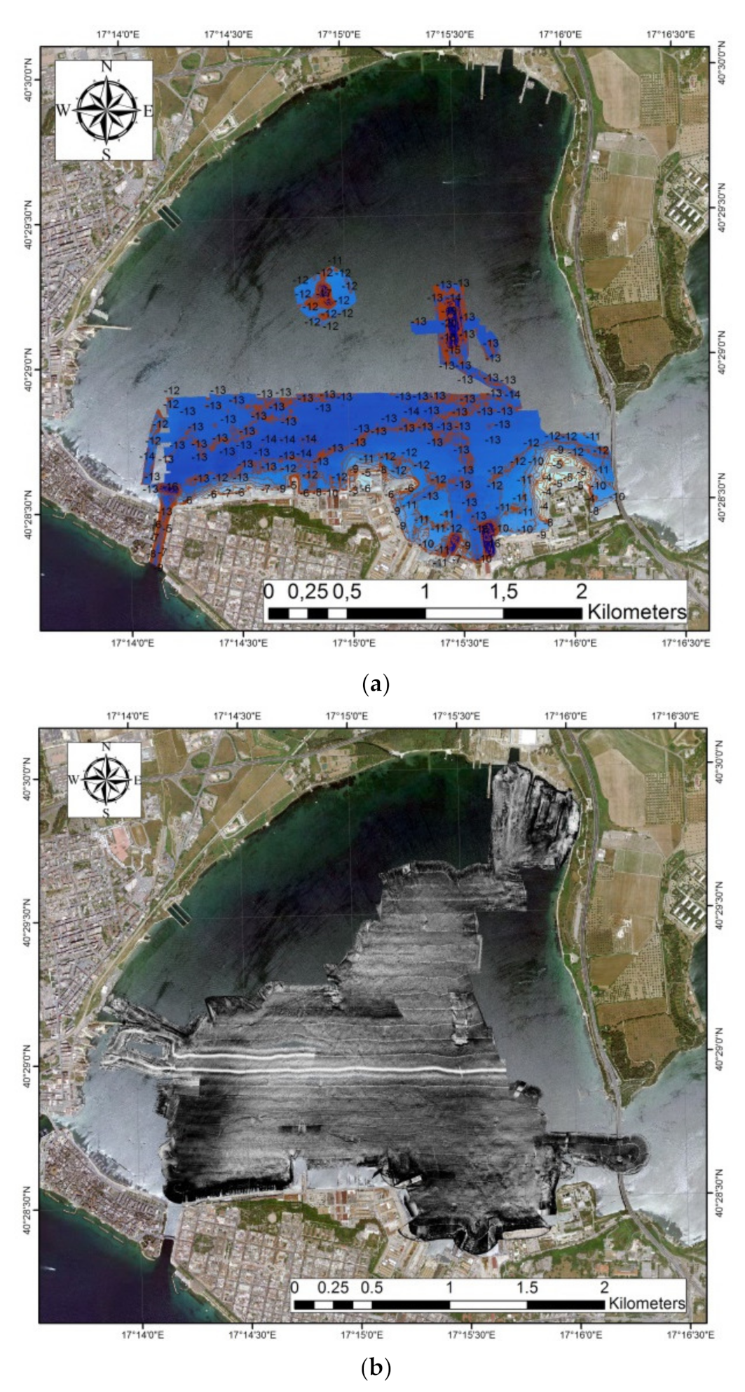
MBES data were processed using CARIS HIPS (professional hydrographic processing software) to produce a digital terrain model (DTM) that was mapped and described using morphometric characterization at a 0.2 m cell resolution (
Figure 7a). SSS data were processed through the IXSEA Delph software to obtain a raster mosaic of the sea-bottom at a 0.2 cm cell-width resolution (
Figure 7b).
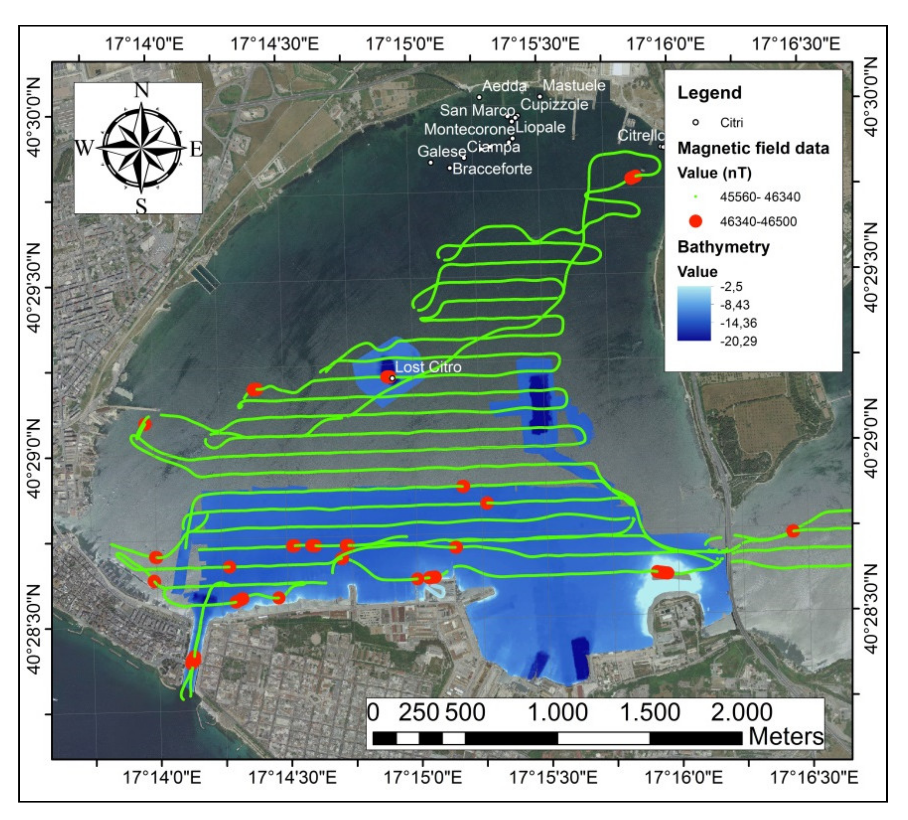
In order to detect other anthropogenic objects or artifacts possibly buried under the basin seabed, a magnetometric survey was performed through a GEOMETRICS G-882 cesium vapor magnetometer connected to the navigation system TELEDYNE PDS 2000. Magnetic field data were collected and exported in the GIS environment project (ESRI) ArcGIS (
Figure 8).
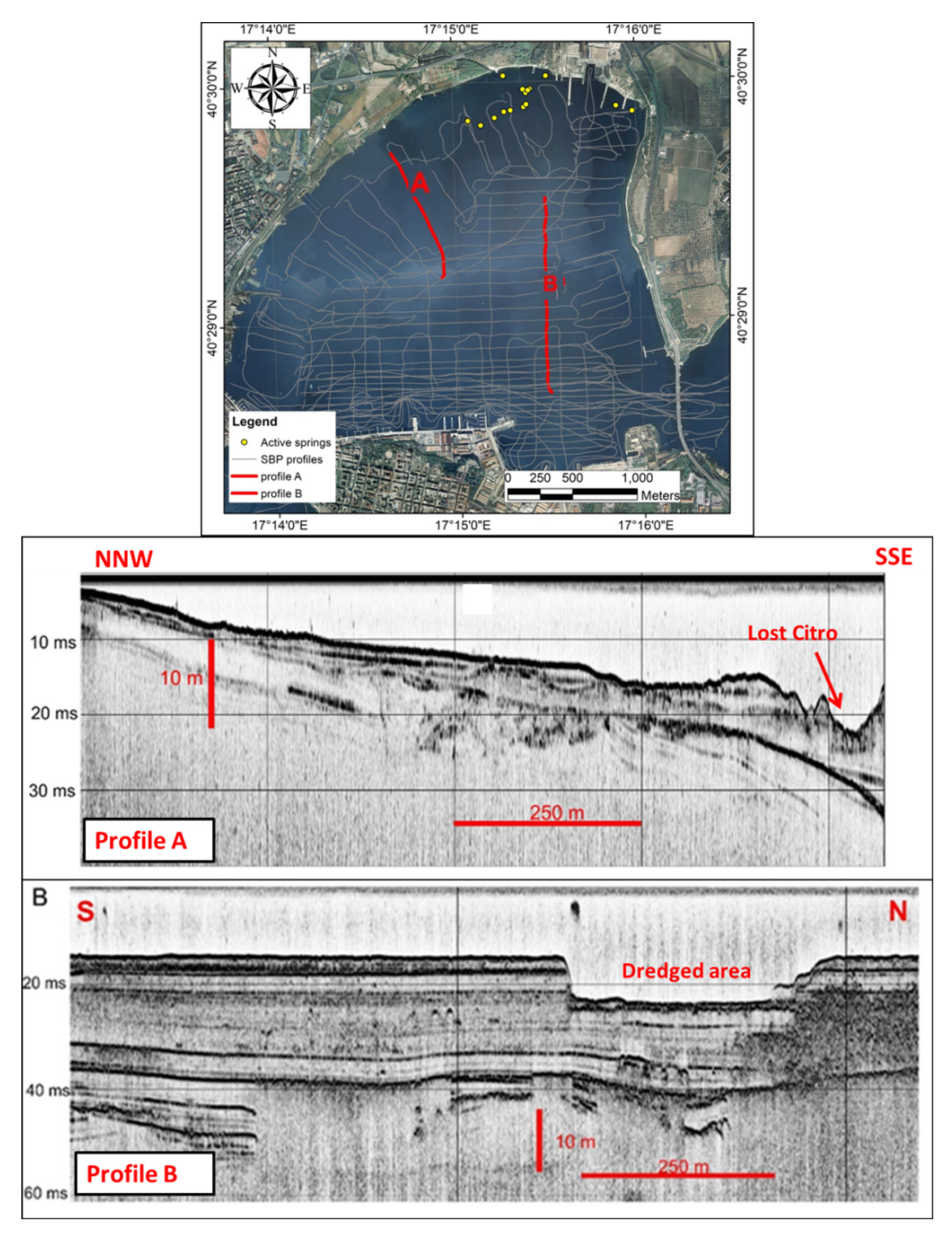
High-resolution stratigraphic data were collected by means of an INNOMAR SES-2000 Compact parametric sub-bottom profiler (SBP), with a primary frequency of 85–115 kHz. This system allowed seismic data acquisition in very shallow water and between the extensive mussel farming structures of the Mar Piccolo (
Figure 9). Seismic data were converted into the SEGY format and processed by the IXSEA Delph software (iXBlue, North America). For the time/depth conversion, an average velocity of 1500 m/s for the water column was used and of 1670 m/s for the sediments through calibration with cores sampled from the Mar Piccolo sea-bottom [
3].
5. Results
The marine geophysical surveys highlighted the sea-floor features in the Primo Seno of the Mar Piccolo basin. The MBES and SSS surveys showed a flat seabed characterized by the occurrence of karst springs and other depressions on the sea-bottom. All active karst springs showed a freshwater outflow visible even on the sea surface.
The magnetic field of sediments on the sea-bottom showed values from 45,560 to 46,340 nT. Some anomalies of about 46,500 nT, mainly located in proximity to the mussel farming plants and close to the shipwrecks and dumping areas.
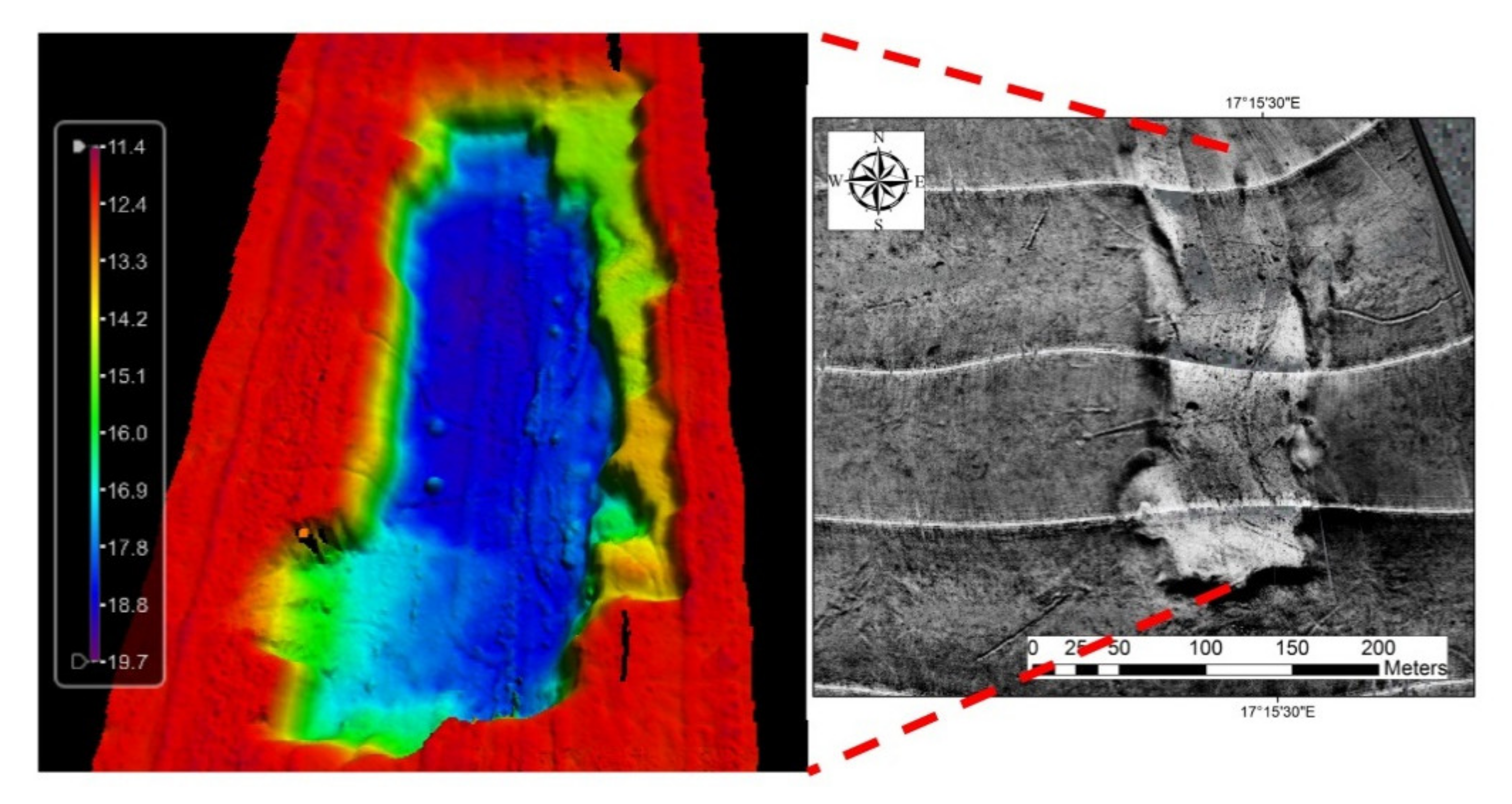
Two main depressions were clearly detected in the middle of the Mar Piccolo Primo Seno:
- I—
a sub-circular depression with a diameter of 106 m, at 17 m wd, located at 17°14′54.2″ E 40°29′14.54″ N (
Figure 9 profile A,
Figure 10);
- II—
a rectangular dredged area 50 m wide and 250 m length, at 19 m wd, located at 17°15′28.11″ E 40°29′8.16″ N (
Figure 9 profile B,
Figure 11).
The sub-circular depression was initially interpreted as “Lost Citro”-like features of natural origin even if no freshwater outflow was reported, like similar features detected and described in the Mar piccolo and Mar Grande basins [
19,
30,
31,
32]. A huge magnetic field anomaly of 46,500 nT was detected close to the “Lost Citro” position. Moreover, another feature was detected as a rectangular depression, clearly detected in the SSS and MBES data approximatively at the Mar Piccolo–Primo Seno center.
Based on the reported location of the Italian Navy fleet anchored in the Mar Piccolo on 2 August 1916, a perfect fit between the wreckage position and “Lost Citro” is clearly shown. The Col. Giannelli’s reported position matches the position and size detected by the MBES survey [
17,
18,
19].
At the occurrence of the circular feature of “Lost Citro”, a strong magnetic anomaly was detected, corresponding to the position of the turret that sank during the explosions on 2 August 1916, as described in the works of Rizza [
17,
18] (
Figure 12). Magnetometric and dive surveys revealed the occurrence of metal frames lying on the depression bottom.
The SSS and MBES data showed the 2500 m long and 45 m wide dredged channel for the dreadnought towing from the wreckage location to the shipyard dock. Caroppo and Portacci [
19] reported Leonardo Da Vinci righted in the middle of the Mar Piccolo Primo Seno, 1300 m away from the shipyard, fitting to the rectangular area position detected by the MBES and SSS data.
The sub-bottom profiler data showed a geometric alteration into the first sediment thickness (about 1 m), extended up to about 200 m far from the “Lost Citro” position. The trench profile was clearly detected through the MBES and SSS data and its position confirmed the anthropogenic origin by the dredging activities. The seismic profiles showed shallow reflectors which abruptly end at the depression escarpment (Profile A in
Figure 9) [
17,
18].
6. Discussion
The new marine geophysical data allowed detecting peculiar sea-floor features in the Mar Piccolo basin. The most important underwater landforms are so-called “Citri”, seabed sub-circular karst springs clearly detected by the MBES and SSS surveys. In particular, the MBES and SSS surveys were useful to detect the field of Citri, mainly located in the northern area of the Mar Piccolo Primo Seno (
Figure 8). In contrast, the two “Citri”-like features were discovered in the center of the Mar Piccolo Primo Seno (
Figure 10 and
Figure 11).
At the “Citri” positions occurrences, freshwater outflows were observed and are visible on the sea surface as well. The first comprehensive studies were carried out by Cerruti [
30,
31], and afterward, “Citri” were studied in order to exploit the freshwater by collection structures [
31,
32,
33].
“Citri” own peculiar features in the Mar Piccolo; outflows come from sub-horizontal karstic conduits developed at the unconformity between Calcarenite di Gravina Fm and Calcare di Altamura Fm. The conduits are well developed, and they were surveyed and measured during diving inspections [
3]. Other small springs were detected directly on the sea-bottom. Most of the vents are clustered, forming a depressed area that can be considered a field of “Citri” [
3,
33].
One of those “Citri”-like features, located approximatively at the Mar Piccolo Primo Seno center [
2,
19], was firstly interpreted as natural origin but never reported as an active spring. It was archived as “ghost” or "Lost Citro" and was no longer considered [
1,
19,
32].
The new high-resolution SSS, MBES, and magnetometric data revealed the evidence of the Leonardo Da Vinci wreckage of the Italian Royal Navy in the proximity of “Lost Citro” position [
1,
17,
18,
32,
33]. The catastrophe of the Leonardo Da Vinci battleship occurred during the night of the 2 August 1916, in the same position where the MBES data detected a sub-circular depression that is comparable in size with the Col. Giannelli’s description of the sinking of the Leonardo Da Vinci [
38]. Moreover, magnetometric data and dive inspections revealed the presence of metal frames in correspondence with the “Lost Citro” position, which can be attributed to the debris of the battleship. A dredged channel was detected during the MBES surveys and its position matches the towing path from the sink point to the shipyard. Towing operations occurred from 15 to 18 September 1919. In the shipyard, the works for the dry ship ended on 6 October 1919 (
Figure 13).
A rectangular dredged area was detected by the MBES and SSS surveys, about 1300 m away from the shipyard, and its position matches the righting dock excavated on 22–24 January 1921.
The explosion, sinking, and recovery operations generated a strong perturbation along the seabed, probably affecting the remarkable sediment thickness. The uppermost consists of very soft recent muds (Holocene), while the lower one is made up of very stiff clay belonging to the argille subappennine informal unit, confirmed by the literature [
17,
18]. The fact that the dreadnought sank in an area with sub-cropping stiff clay (argille subappennine) probably avoided the further sinking of the battleship under the soft seabed. On the other hand, if the wreckage occurred in other parts of the basin where thick soft muds occur at the seabed, the wreck could be buried deeply under such seabed sediments. At the same time, the recent Holocene sediments are easier to be trenched than the stiff clays.
In the seismic profiles of the SBP, it is possible to observe signal attenuations in some areas (
Figure 9 Profile B) which were attributed to gas venting or to fluid accumulation inside the tephra layer of the Pomici di Mercato eruption (8890 ± 90 cal yr BP) [
3,
40,
41]. The SBP profiles over the special dock used to right the battleship showed that only soft sediments were removed during the excavation works.
7. Conclusions
Marine geophysical surveys are essentials for a lot of applications, from geological studies to environmental remediation. Improved modern marine geophysical surveys have yielded high-resolution data for seabed features and for the identification of archaeological/historical wrecks.
In this study, marine geophysical data were collected in the Primo Seno of Mar Piccolo of Taranto. The magnetometric, morphobathymetric, and seismostratigraphic data and their correlation allowed detecting peculiar sea-floor features of anthropogenic origin. A correlation between the marine geophysical data and historical documents highlighted the sea-floor features due to the wreckage and towing operations of the battleship Leonardo Da Vinci of the Italian Royal Navy.
The Leonardo Da Vinci recovery showed its phases in the following detected sea-floor features:
A sub-circular depression due to the sinking of the Leonardo Da Vinci during the night of 2 August 1916, and to the excavation works for the subsequent recovery operations;
A channel dredged for the battleship towing operations to the shipyard docks, which ended on 18 September 1919;
A rectangular seabed feature consisting of a dredged area for the wreck righting operations excavated on 22–24 January 1921.
A particular focus was given to the sub-circular depression correspondent to the sinking position of the battleship. At first, this sea-floor feature was attributed to a karst spring, as others occurred in the Mar Piccolo and Mar Grande with similar shapes, but a freshwater outflow was never reported at that location. Magnetometric and diving inspections showed some anomalies in correspondence with the sub-circular depression. A correlation between the historical documents and morphobathymetric surveys showed a perfect fit between the sub-circular depression and the Leonardo Da Vinci wreckage position. However, other detected features, near the sinking position, are connected to each other, and fit spatially and temporally to the historical sequence of the Leonardo Da Vinci recovery operations.
Finally, the depression known as “Lost Citro” was attributed to the footprints of the Leonardo Da Vinci wreckage. Further activities must be performed to understand both the magnetic anomaly recorded and the nature of the objects and frames detected in the “Lost Citro”.
Author Contributions
Conceptualization, G.S. (Giovanni Scardino), F.D.G. and G.M.; methodology, F.D.G., G.M.; software, F.D.G., E.V.; validation, E.V., G.S. (Giovanni Scardino) and M.M.; formal analysis, E.V., G.S. (Giovanni Scardino) and M.M.; investigation, M.D., G.S. (Giovanni Scardino) and P.D.; resources, G.M.; data curation, E.V., G.S. (Giovanni Scardino), and P.F.; writing—original draft preparation, G.S. (Giovanni Scardino); writing—review and editing, F.D.G. and G.M.; visualization, G.S. (Gianluca Saccotelli), E.V. and P.F.; supervision, G.M.; project administration, G.M., R.V., G.C., and V.C.; funding acquisition, R.V., G.C., V.C., and G.M. All authors have read and agreed to the published version of the manuscript.
Funding
This study was funded by the Italian Environment Ministry and was conducted within the framework of the Collaboration Agreement (ex article 15 of law 241/90) “Activities of common interest preparatories for the remediation, environmentalization and redevelopment of the Mar Piccolo of Taranto” between the Government Commissioner for the Remediation of the Taranto area (Dr. V. Corbelli) and University of Bari and the National Research Council (responsible for the geological survey TEOT Phases D and G: G. Mastronuzzi). It was also partially funded by the Italian Ministry of Education, University and Research (MIUR Funds-Ph.D. in Geosciences, Bari University, Responsible M. Moretti).
Acknowledgments
We are thankful to the Government Commissioner for the Remediation of the Taranto area, V. Corbelli, and her collaborators for their financial, logistic, and scientific support in every phase of this project, and Angelo Tursi, scientific responsible for the agreement during environmental activities on the Mar Piccolo. We wish to thank all the staff at the Polo Scientifico e Tecnologico Magna Grecia PST (Taranto).
Conflicts of Interest
The authors declare no conflict of interest.
References
- Bracchi, V.; Marchese, F.; Savini, A.; Chimienti, G.; Mastrototaro, F.; Tessarolo, C.; Cardone, F.; Tursi, A.; Corselli, C. Seafloor integrity of the Mar Piccolo Basin (Southern Italy): Quantifying anthropogenic impact. J. Maps 2016, 12, 1–11. [Google Scholar] [CrossRef] [Green Version]
- Lisco, S.; Corselli, C.; De Giosa, F.; Mastronuzzi, G.; Moretti, M.; Siniscalchi, A.; Marchese, F.; Bracchi, V.; Tessarolo, C.; Tursi, A. Geology of Mar Piccolo, Taranto (southern Italy): The physical basis for remediation of a polluted marine area. J. Maps 2016, 12, 173–180. [Google Scholar] [CrossRef] [Green Version]
- Valenzano, E.; Scardino, G.; Cipriano, G.; Fago, P.; Capolongo, D.; De Giosa, F.; Lisco, S.; Mele, D.; Moretti, M.; Mastronuzzi, G. Holocene morpho-sedimentary evolution of the Mar Piccolo basin (Taranto, Southern Italy). Geogr. Fis. Din. Quat. 2018, 41, 119–135. [Google Scholar] [CrossRef]
- Quarta, G.; Fago, P.; Calcagnile, L.; Cipriano, G.; D’Elia, M.; Moretti, M.; Scardino, G.; Valenzano, E.; Mastronuzzi, G. 14C Age Offset in the Mar Piccolo Sea Basin in Taranto (Southern Italy) Estimated on Cerastoderma Glaucum (Poiret, 1789). Radiocarbon 2019, 61, 1387–1401. [Google Scholar] [CrossRef]
- Vitone, C.; Federico, A.; Puzrin, A.M.; Ploetze, M.; Carrassi, E.; Todaro, F. On the geotechnical characterisation of the polluted submarine sediments from Taranto. Environ. Sci. Pollut. Res. 2016, 23, 12535–12553. [Google Scholar] [CrossRef]
- Todaro, F.; Gisi, S.D.; Labianca, C.; Notarnicola, M. Combined assessment of chemical and ecotoxicological data for the management of contaminated marine sediments. Environ. Eng. Manag. J. 2019, 18, 2287–2296. [Google Scholar]
- Bortone, I.; Labianca, C.; Todaro, F.; De Gisi, S.; Coulon, F.; Notarnicola, M. Experimental investigations and numerical modelling of in-situ reactive caps for PAH contaminated marine sediments. J. Hazard. Mater. 2020, 387, 121724. [Google Scholar] [CrossRef] [PubMed]
- Tursi, A.; Corbelli, V.; Cipriano, G.; Capasso, G.; Velardo, R.; Chimienti, G. Mega-litter and remediation: The case of Mar Piccolo of Taranto (Ionian Sea). Rend. Lincei. Sci. Fis. Nat. 2018, 29, 817–824. [Google Scholar] [CrossRef]
- Madricardo, F.; Foglini, F.; Campiani, E.; Grande, V.; Catenacci, E.; Petrizzo, A.; Kruss, A.; Toso, C.; Trincardi, F. Assessing the human footprint on the sea-floor of coastal systems: The case of the Venice Lagoon, Italy. Sci. Rep. 2019, 9, 1–13. [Google Scholar] [CrossRef]
- Rivera, J.; Mateu, G.; Hermida, N.; Pomar, L.; Acosta, J. Trawl Marks and Dredge Spoils as Examples of Seabed Anthropic Alteration on Sediments (Menorca Shelf). In Atlas of Bedforms in the Western Mediterranean; Guillén, J., Acosta, J., Chiocci, F.L., Palanques, A., Eds.; Springer International Publishing: Berlin/Heidelberg, Germany, 2017; pp. 167–172. ISBN 978-3-319-33940-5. [Google Scholar]
- Fuortes, A. Il problema tecnico pel “recupero della Leonardo da Vinci”. Rass. Tec. Pugl. Period. Mens. Coll. Ing. Archit. 1916, 15, 10–11. [Google Scholar]
- Goodsir, F.; Lonsdale, J.A.; Mitchell, P.J.; Suehring, R.; Farcas, A.; Whomersley, P.; Brant, J.L.; Clarke, C.; Kirby, M.F.; Skelhorn, M.; et al. A standardised approach to the environmental risk assessment of potentially polluting wrecks. Mar. Pollut. Bull. 2019, 142, 290–302. [Google Scholar] [CrossRef]
- Browne, K. “Ghost Battleships” of the Pacific: Metal Pirates, WWII Heritage, and Environmental Protection. J. Mari. Arch. 2019, 14, 1–28. [Google Scholar] [CrossRef]
- Casoli, E.; Ventura, D.; Cutroneo, L.; Capello, M.; Jona-Lasinio, G.; Rinaldi, R.; Criscoli, A.; Belluscio, A.; Ardizzone, G.D. Assessment of the impact of salvaging the Costa Concordia wreck on the deep coralligenous habitats. Ecol. Indic. 2017, 80, 124–134. [Google Scholar] [CrossRef]
- Amir-Heidari, P.; Arneborg, L.; Lindgren, J.F.; Lindhe, A.; Rosén, L.; Raie, M.; Axell, L.; Hassellöv, I.-M. A state-of-the-art model for spatial and stochastic oil spill risk assessment: A case study of oil spill from a shipwreck. Environ. Int. 2019, 126, 309–320. [Google Scholar] [CrossRef]
- Giorgerini, G.; Nani, A. Le navi di Linea Italiane; Ufficio Storico della Marina: Roma, Italy, 1962. [Google Scholar]
- Rizza, C. Il caso “Da Vinci” pp.I. Stor. Mil. 2017, 283–XXV, 58–65. [Google Scholar]
- Rizza, C. Il caso “Da Vinci” pp.II. Stor. Mil. 2017, 2843–XXV, 59–66. [Google Scholar]
- Caroppo, C.; Portacci, G. The First World War in the Mar Piccolo of Taranto: First case of warfare ecology? Ocean Coast. Manag. 2017, 149, 135–147. [Google Scholar] [CrossRef]
- Newell, R.C.; Seiderer, L.J.; Hitchcock, D.R. The impact of dredging works in coastal waters: A review of the sensitivity to disturbance and subsequent recovery of biological resources on the sea bed. Oceanogr. Mar. Biol. Annu. Rev. 1998, 36, 127–178. [Google Scholar]
- Tengberg, A.; Hassellöv, I.-M.; Landquist, H.; Lindgren, F.; Apler, A.; Larsson, C.; Olsson, U.; Paka, V.; Golenko, M.; Shchuka, S. Sustainable management of oil polluting wrecks and chemical munitions dump sites. In Proceedings of the OCEANS 2017-Aberdeen, Aberdeen, Scotland, 19–22 June 2017; pp. 1–4. [Google Scholar]
- De Giosa, F.; Scardino, G.; Vacchi, M.; Piscitelli, A.; Milella, M.; Ciccolella, A.; Mastronuzzi, G. Geomorphological Signature of Late Pleistocene Sea Level Oscillations in Torre Guaceto Marine Protected Area (Adriatic Sea, SE Italy). Water 2019, 11, 2409. [Google Scholar] [CrossRef] [Green Version]
- Mastronuzzi, G.; Artusa, C.; Fontolan, G.; Longo, D.; Milella, M.; Pignatelli, C.; Piscitelli, A. Underwater surveys in the reconstruction of Upper Pleistocene-Holocene sea level changes in the Taranto seas. Rend. Online Soc. Geol. Ital. 2012, 21, 1176–1178. [Google Scholar]
- Belluomini, G.; Caldara, M.; Casini, C.; Cerasoli, M.; Manfra, L.; Mastronuzzi, G.; Palmentola, G.; Sanso, P.; Tuccimei, P.; Vesica, P.L. The age of Late Pleistocene shorelines and tectonic activity of Taranto area, Southern Italy. Quat. Sci. Rev. 2002, 21, 525–547. [Google Scholar] [CrossRef]
- Amorosi, A.; Antonioli, F.; Bertini, A.; Marabini, S.; Mastronuzzi, G.; Montagna, P.; Negri, A.; Rossi, V.; Scarponi, D.; Taviani, M.; et al. The Middle–Upper Pleistocene Fronte Section (Taranto, Italy): An exceptionally preserved marine record of the Last Interglacial. Glob. Planet. Chang. 2014, 119, 23–38. [Google Scholar] [CrossRef]
- Negri, A.; Amorosi, A.; Antonioli, F.; Bertini, A.; Florindo, F.; Lurcock, P.C.; Marabini, S.; Mastronuzzi, G.; Regattieri, E.; Rossi, V.; et al. A potential global boundary stratotype section and point (GSSP) for the Tarentian Stage, Upper Pleistocene, from the Taranto area (Italy): Results and future perspectives. Quat. Int. 2015, 383, 145–157. [Google Scholar] [CrossRef]
- Mastronuzzi, G.; Sansò, P. Morfologia e genesi delle Isole Chéradi e del Mar Grande (Taranto, Puglia, Italia). Geogr. Fis. Din. Quat. 1998, 21, 131–138. [Google Scholar]
- Mastronuzzi, G. Evoluzione dell’orografia antica della città di Taranto. In Dal Kastron bizantino al Castello aragonese”, Scorpione Editrice, Taranto; D’angela, C., Ricci, F., Eds.; Scorpione Editrice: Taranto, Italy, 2006; pp. 123–140. [Google Scholar]
- Mastronuzzi, G.; Boccardi, L.; Candela, A.; Colella, C.; Curci, G.; Giletti, F.; Milella, M.; Pignatelli, C.; Piscitelli, A.; Ricci, F.; et al. Il Castello Aragonese di Taranto in 3D Nell’evoluzione del Paesaggio Naturale; DIGILABS: Bari, Italy, 2013; p. 171. [Google Scholar]
- Cerruti, A. Le sorgenti sottomarine del Mar Grande e del Mar Piccolo di Taranto. Ann. R. Ist. Nav. Napoli 1938, VII, 171–196. [Google Scholar]
- Cerruti, A. Ulteriori notizie sulle sorgenti sottomarine (citri) del Mar Grande e del Mar Piccolo di Taranto e sulla loro eventuale utilizzazione. Boll. Pesca Piscic. Idrobiol. 1948, XXIV, 57–72. [Google Scholar]
- Parenzan, P. Il Mar Piccolo e il Mar Grande di Taranto. Carta biocenotica. Thalass. Salentina 1969, 3, 19–34. [Google Scholar]
- Parenzan, P. Il sedimento conchiglifero del I seno del Mar Piccolo di Taranto. Thalass. Salentina 1969, 3, 67–106. [Google Scholar]
- Zuffianò, L.E.; Basso, A.; Casarano, D.; Dragone, V.; Limoni, P.P.; Romanazzi, A.; Santaloia, F.; Polemio, M. Coastal hydrogeological system of Mar Piccolo (Taranto, Italy). Environ. Sci. Pollut. Res. Int. 2015, 23, 12502–20514. [Google Scholar] [CrossRef]
- Stefanon, A.; Cotecchia, F. Prime notizie sulle caratteristiche di efflusso e modalità di investigazione delle sorgenti subacquee ai fini di una loro captazione. Quad. Ric. Sci. 1969, 58, 165–195. [Google Scholar]
- Cotecchia, V.; Lollino, G.; Pagliarulo, R.; Stefanon, A.; Tadolini, T.; Trizzino, R. Studi e controlli in situ per la captazione della sorgente sottomarina Galeso Mar Piccolo di Tarant. In Proceedings of the International Congress of Geo-engineering, Torino, Italy, 27–30 September 1989; pp. 27–30. [Google Scholar]
- Cotecchia, F.; Lollino, G.; Pagliarulo, R.; Stefanon, A.; Tadolini, T.; Trizzino, R. Hydrogeological conditions and field monitoring of the Galeso submarine spring in the Mar Piccolo of Taranto (Southern Italy). In Proceedings of the XI Salt Water Intrusion Meeting, Torino, Italy, 14–17 May 1990; pp. 171–208. [Google Scholar]
- Guidoni, A. The Salvage of the "Leonardo Da Vinci". In Proceedings of United State Naval Institute; United State Naval Institute: Annapolis, MD, USA, 1921; pp. 1–2. [Google Scholar]
- Ferrajolo, L. Observation of the 3rd August 1916 at 8.00 a.m. Boll. Meteor. Reg. Uff. Cent. Meteorol. Geodin. Roma 1916, 38, 216. [Google Scholar]
- Mele, D.; Sulpizio, R.; Dellino, P.; La Volpe, L. Stratigraphy and eruptive dynamics of a pulsating Plinian eruption of Somma-Vesuvius: The Pomici di Mercato (8900 years B.P.). Bull. Volcanol. 2011, 73, 257–278. [Google Scholar] [CrossRef]
- Aulinas, M.; Civetta, L.; Di Vito, M.A.; Orsi, G.; Gimeno, D.; Férnandez-Turiel, J.L. The “Pomici di mercato” Plinian eruption of Somma-Vesuvius: Magma chamber processes and eruption dynamics. Bull. Volcanol. 2008, 70, 825–840. [Google Scholar] [CrossRef]
© 2020 by the authors. Licensee MDPI, Basel, Switzerland. This article is an open access article distributed under the terms and conditions of the Creative Commons Attribution (CC BY) license (http://creativecommons.org/licenses/by/4.0/).

 ,
, 


