Article

Channel Width Variation Phases of the Major Rivers of the Campania Region (Southern Italy) over 150 Years: Preliminary Results

1
Department of Sciences and Technologies, University of Sannio, 82100 Benevento, Italy
2
C.U.G.RI., Inter University Centre for the Prediction and Prevention of Major Hazards, 84084 Fisciano, Italy
*
Author to whom correspondence should be addressed.
Submission received: 1 June 2021 / Revised: 24 June 2021 / Accepted: 25 June 2021 / Published: 30 June 2021

Abstract

:
In recent decades, rivers in Southern Italy experienced remarkable channel changes. Studies on this topic are relatively recent, and yet, far from defining a morpho-evolutionary trend that is common to all rivers of this area. The types and roles of the different controlling factors are still debated. In this study, we present preliminary results about the width channel changes of major rivers in the Campania region (Southern Italy) in the last 150 years. The aim is to provide new insights that are useful to define morpho-evolutionary trajectories at a regional scale and shed light on the roles played by controlling factors. To this aim, we carried out a GIS-aided geomorphological analysis of topographic maps and orthophotos. The results showed the existence of at least three main phases of channel width variations. Between the 1870s and 1930s (Phase 1), most of the rivers experienced widening. Between the 1930s and late 1990s (Phase 2), all of the rivers underwent dramatic narrowing at high rates. Finally, from the 1990s onwards, no dominant trend was found and variations were negligible. Land-use changes at the basin scale and rainfall changes at a decadal scale are likely the main controlling factors, while variations in human disturbances and local factors seem responsible for changes in general trends.

1. Introduction

River channels of Southern Italy are representative of a much wider morphoclimatic scenario, i.e., the Mediterranean area [1,2]. Thus, investigating their short-term morphological changes is of great importance, also in the framework of flood risk assessment and river management [3,4]. An almost total lack of information existed for rivers in Southern Italy, at least up until the early 2010s, which is different from rivers located in northern and central part of Italy [5]. Recently, several papers partially filled this gap [2,6,7,8,9,10,11]. In particular, Scorpio et al. [7] compared the channel changes experienced by some rivers located in the different regions of Southern Italy during the last 150 years, and observed three distinct phases of channel adjustments. However, even if all of the studied rivers displayed incision and severe narrowing during the second phase (i.e., from the 1950s to the end of the 1990s), contrasting behaviors among different rivers were observed during the first (i.e., from the last decades of the 19th century to the 1950s) and the third phase (i.e., from the 1990s onwards). Thus, a morpho-evolutionary trajectory that is common to all the rivers of Southern Italy is still far from being defined. Similarly, different authors debate over the type and the role of the different controlling factors in channel changes. As most of the investigated rivers of Southern Italy are intensely anthropized, most of the above-listed authors suggested a dominant role played by human disturbances (i.e., in-channel sediment mining, channelization, and building of cross works, such as dams). However, Magliulo et al. [2] recently demonstrated that, among the rivers located in Southern Italy, the Tammaro River underwent the same channel changes experienced by intensely anthropized rivers, notwithstanding it was affected by negligible in-channel human disturbances. Thus, the authors suggested a more relevant role played by both extreme floods and interactions between rainfall changes at a decadal scale, and land-use changes at the catchment scale, in controlling channel adjustments. Such interpretation is in good accordance with the vast literature on this topic. In particular, Arnaud-Fassetta [12], in a study carried out on the river channel changes in the Rhone Delta (France), found that the decrease of flood frequency, together with sediment dredging and building of dams, caused a reduction of sediment yield that, in turn, caused channel incision. Hooke [13] demonstrated the high degree of adjustments experienced by two fluvial systems in SE to occasional, high magnitude, flash flood events. Similarly, Kiss and Blanka [14] found that the main morphological changes experienced by the Hernád River (Hungary) were determined by an altered water regime caused by precipitation change and engineering works. Rădoane et al. [15] examined the channel changes experienced by seven major rivers in eastern Romania, which resulted in being highly responsive to both climatic signals and anthropogenic factors. Finally, Liébault and Piégay [16] demonstrated the impact of land-use changes at the basin scale (in particular, afforestation) on channel narrowing and incision of a large set of rivers and streams located in southeastern France.
This study compares the channel width changes experienced by four of the major rivers of the Campania region (Southern Italy) in the last 150 years. The aim is to provide new insights to define a common morpho-evolutionary trend for the rivers of Southern Italy and understand the roles played by different controlling factors. The presented results must be considered preliminary, as an analysis at both the reach and the catchment scale is unquestionably needed. However, the discussion of the obtained results in the framework of the pre-existing scientific literature, dealing with land-use changes, variations at the decadal scale in the rainfall regimes, and human disturbances at the reach, river, and catchment scale provided useful reflections that need to be explored by further studies.

2. Materials and Methods
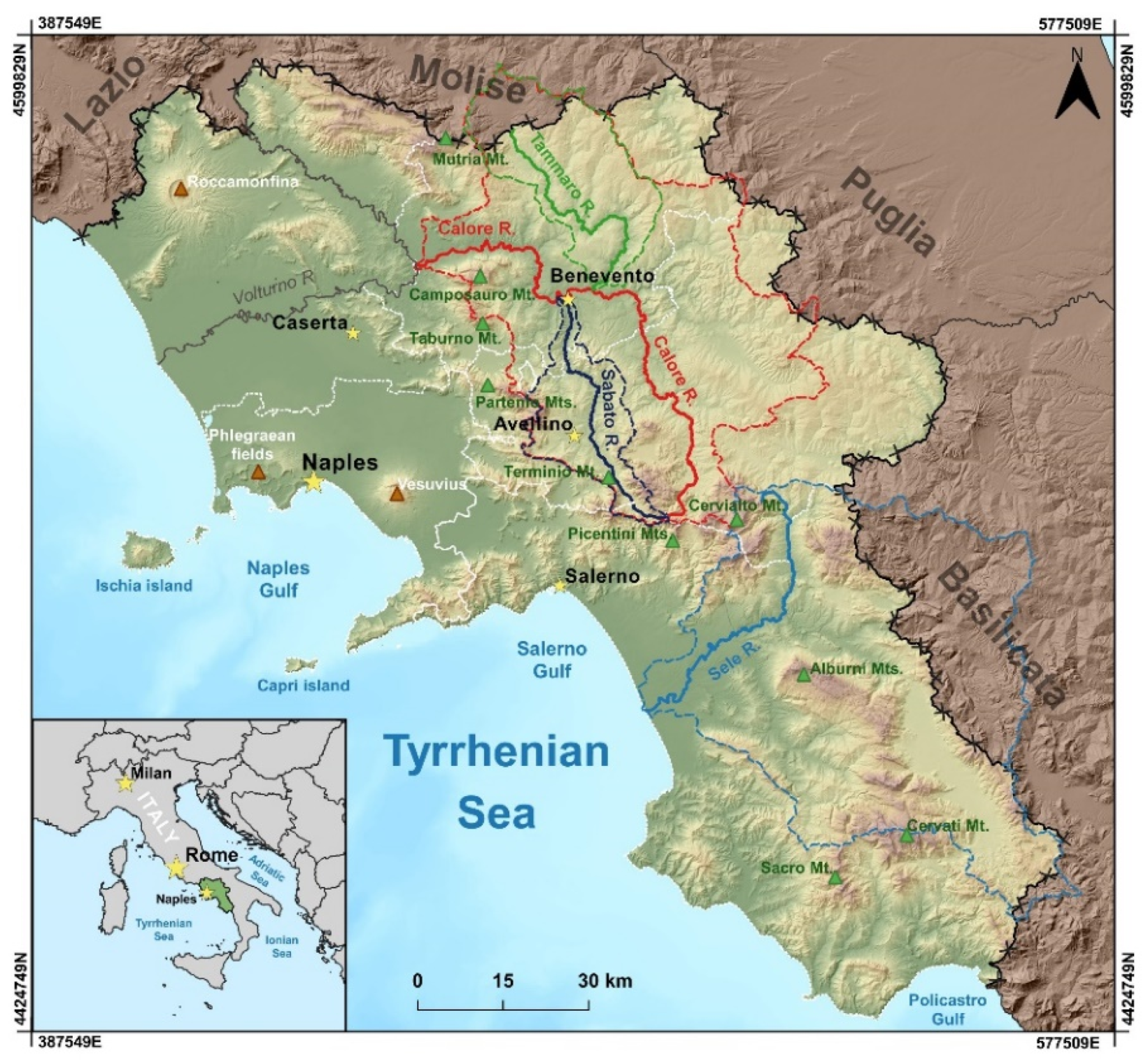
2.1. Study Area

The Campania region is located in the northwestern sector of Southern Italy (Figure 1). It has an area of ~590 km2 and could be subdivided into three main physiographic units sensu [17], i.e., (i) the Apennine mountain range, which reaches altitudes of ~1000 to >2000 m a.s.l. and accounts for ~30% of the total area; (ii) the low-altitude hills and alluvial valleys for a further 52%, approximately; and (iii) the coastal plains that account for the remnant part [18].
The climate of the Campania region is of a Mediterranean type with hot and dry summers and moderately cool and rainy winters [19,20]. Mean annual air temperatures range between 10 and 12 °C in the inner areas and 13 and 15 °C along the coast, while rainfall regimes vary from the coastal or Mediterranean type to the Apennine sublittoral, which is characterized by a principal maximum in autumn–winter and a minimum in the summer [21]. The lowest mean annual rainfall, approximately 700–900 mm, occurs in the western and eastern parts of the Campania region; the highest mean annual rainfall, approximately 1700–2000 mm, occurs in the central part of the Apennine ridge [18]. According to Diodato [22], the wettest periods occurred in the 19th century. Longobardi and Villani [23] found a negative precipitation trend in the period 1918–1999. This latter comprises two relatively wet periods (i.e., middle 1930s–middle 1940s and early 1960s–late 1970s) and two relatively dry periods (i.e., middle 1940s–early 1960s and late 1970s–early 2010s) [18,23].
The main rivers that mostly or entirely flow in the Campania region are Volturno, Tanagro, Calore, Sele, Tammaro, and Sabato Rivers (Figure 1). The last four rivers were investigated in this study. Table 1 shows their main features.
The investigated rivers flow into two main basins (i.e., Calore River and Sele River basins), as the Tammaro and Sabato Rivers are the main tributaries of the Calore River (Figure 1). Table 2 reports the main features of the investigated basins.
The Sele River flows across all the physiographic units listed above (i.e., Apennine mountain range, low-altitude hills/alluvial valleys, and coastal plain) and, finally, into the Tyrrhenian Sea. Differently, the Calore River basin is an inner basin, as it is the main left tributary of the Volturno River. The Calore River basin includes parts of the mountain range and hills/alluvial plains physiographic units only.
From a geological standpoint, the upper sectors of the studied river basins are mainly shaped into limestone and dolostone, Triassic to Cretaceous in age [24,25]. The hilly sectors of these basins have a terrigenous bedrock, mainly Miocene to Pliocene-aged. The investigated rivers flow into morphostructural depressions infilled with alluvial, volcanic, and slope deposits [26,27,28]. In some cases (e.g., Sele River valley and lower Calore River valley), Quaternary alluvial deposits form very thick sedimentary successions [29,30]. Finally, the coastal portion of the Sele River basin is mainly made up of beach and dune-ridge sandy deposits, back-ridge flat depression deposits, and travertines [31].
From a geomorphological point of view, steep slopes, locally deeply dissected by gorges, characterize the sectors of the basins shaped into the calcareous deposits. At the top of these slopes, karstified remnants of ancient erosional landscapes (paleosurfaces or Paleosuperfici Auct.) are present [26,30]. In contrast, the hilly relieves shaped into the terrigenous deposits are gently sloping and gently rolling. Severe water erosion and mass movements affect these relieves. Thick successions of alluvial and slope deposits, often forming coalescent and/or telescopically arranged alluvial fans, connect the slopes to the alluvial plains. The latter are characterized by a different order of river terraces. Locally, structural terraces shaped into pyroclastic deposits (i.e., Campanian Ignimbrite) and travertines are present.
The land-use in the Campania region experienced remarkable changes on a decadal scale during the last 150 years. Between the mid-1800s and 1930s, a diffuse deforestation occurred, with peaks in the periods 1870s–1890s and 1900s–1930s [32]. In contrast, from the 1930s onwards, Southern Italy experienced forest expansion, especially since the 1950s, due to land abandonment in the mountain areas and inland hills and displacement of agricultural activities to alluvial and coastal plains [33,34,35]. Most human interventions along the river channels occurred between the 1960s and 1990s [7]. In particular, in-channel sediment mining was particularly intense and widespread between the early 1980s and 1990s, when local laws forbade it. Finally, the Sele River and the Tammaro River were dammed in 1934 (Persano dam) and 2006 (Campolattaro dam), respectively.

2.2. Data Source and Methodology
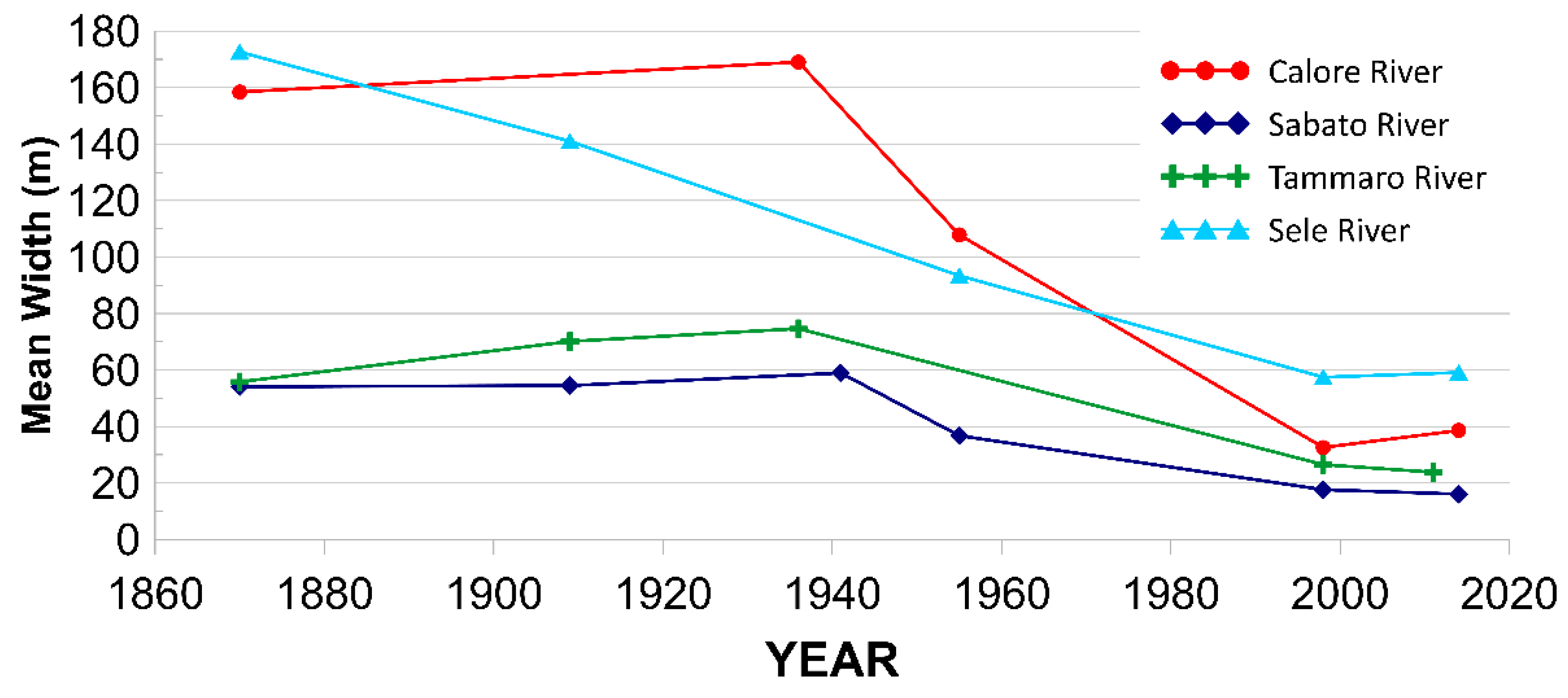
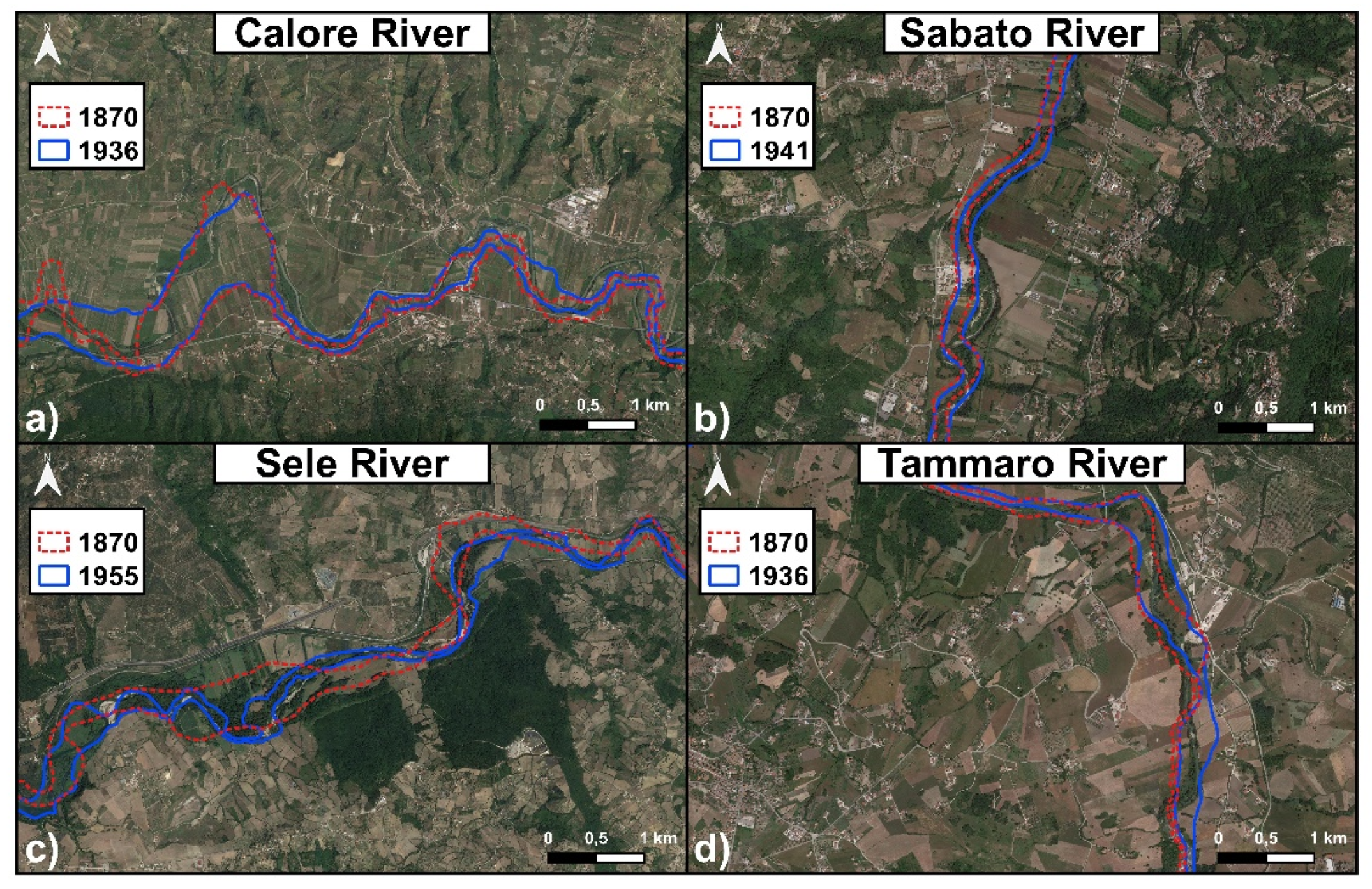
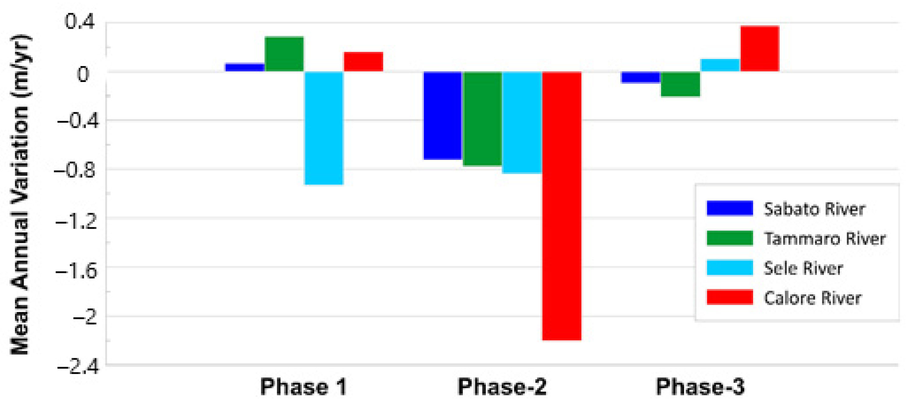
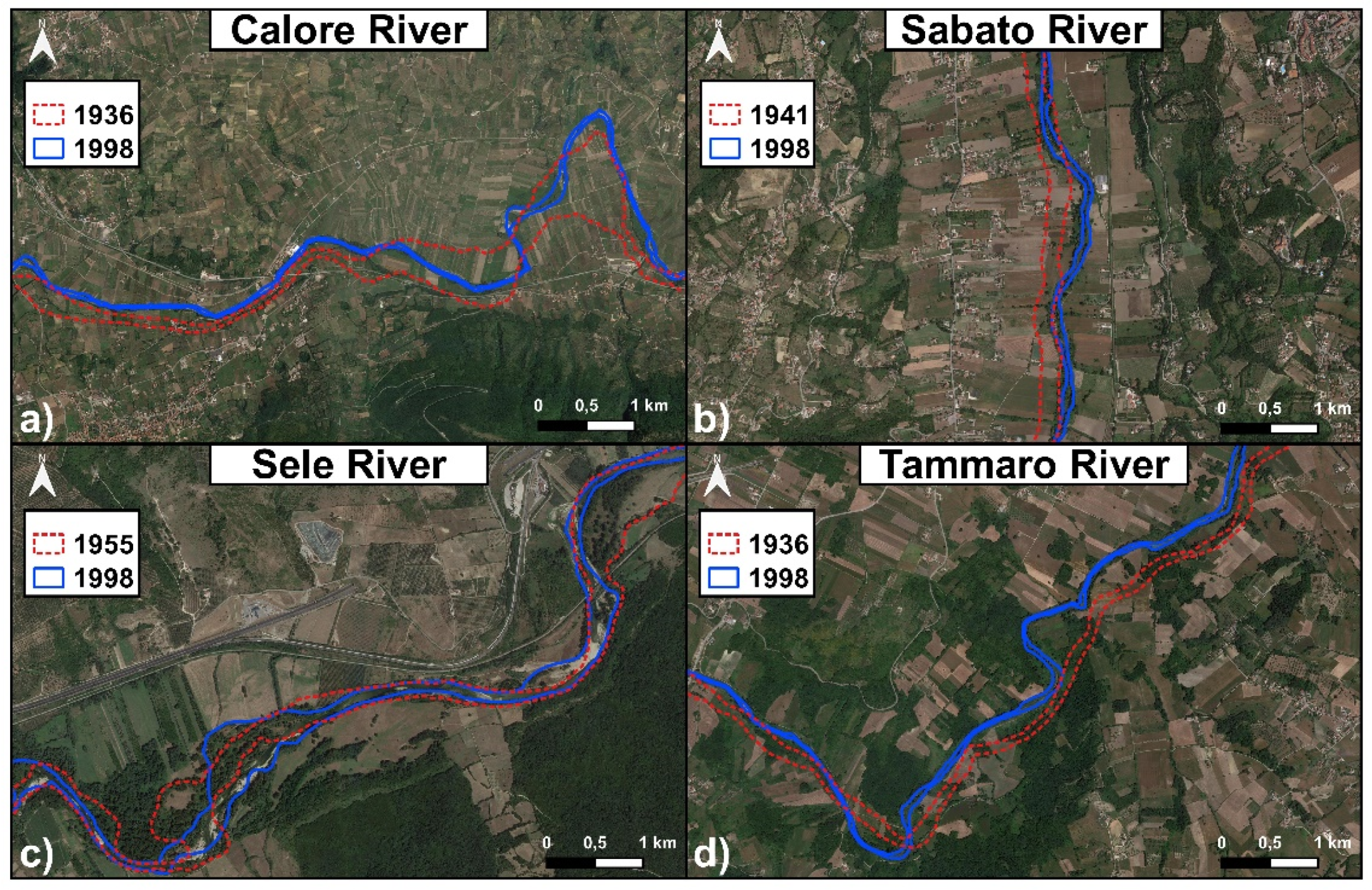
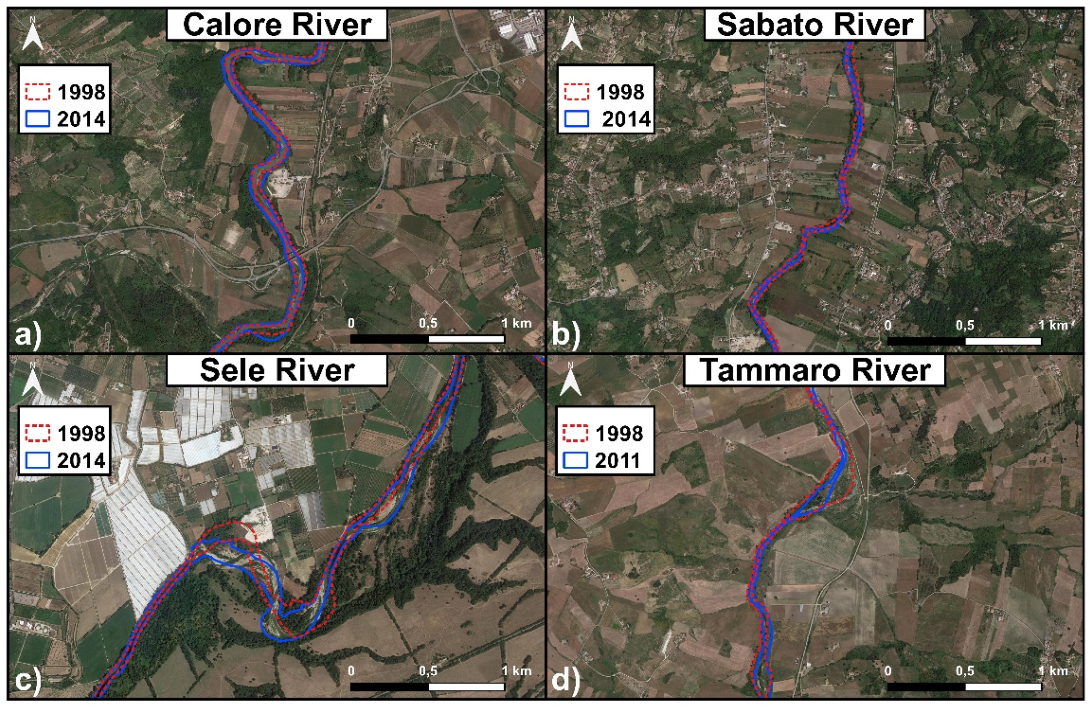
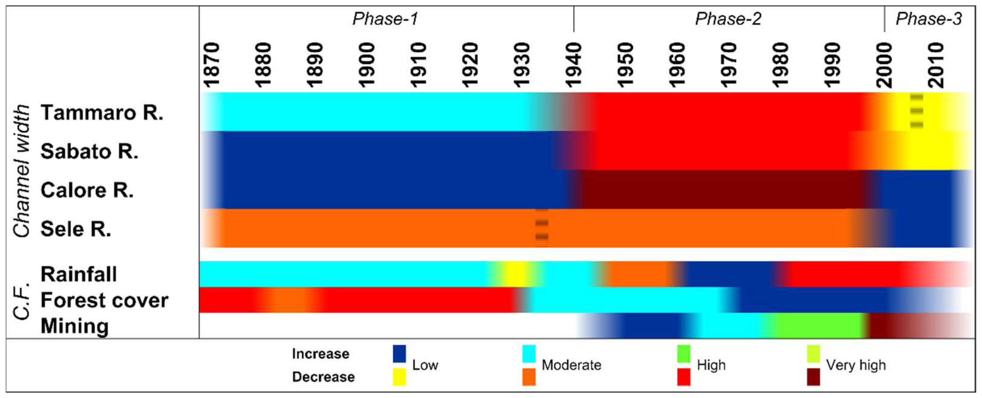
We carried out a multitemporal analysis of the active channel mean width variations of the investigated rivers using widely accepted, classical techniques of GIS-aided geomorphological analysis. ArcGIS® 10.3 software was used. Historical topographic maps, provided by the Italian Geographical Military Institute (IGMI), at a scale of 1:50,000, and produced in 1870, 1909, 1936, and 1941, were scanned at a resolution of 300 and 600 dpi. We imported the maps into the ArcGIS® 10.3 software and georeferenced them in the UTM-WGS84 coordinate system. As a base layer for georeferentiation, we used large-scale topographic maps and selected a number (ranging from 30 to 40) of ground-control points (GCPs), generally located near the active channel. We also performed a map analysis on 1:25,000-scaled topographic maps from 1955, scanned at a resolution of 1200 dpi, and published by IGMI. The topographic maps issuer provided the maps as a file already georeferenced in the UTM-WGS84 coordinate system. We carried out aerial photo analyses on 1:10,000 to 1:5000-scaled color orthophotos from 1998, 2011, and 2014. The Regione Campania authority provided the orthophotos as files georeferenced in the UTM-WGS84 coordinate system. Table 3 summarizes the main characteristics of materials we used.
We manually digitized, in a GIS environment, the active channels of the investigated rivers from different dates. On topographic maps, active channels were easily identified as their main morphological features (i.e., riverbanks, fluvial scarps, fluvial bars), marked by proper symbols. On the orthophotos, the channels were visually recognized. During digitation in a GIS environment, the working scale was always set at 1:4000 or larger. Channel segments that were too narrow and/or hidden by overhanging riparian arboreal vegetation were excluded from the analysis, as it was not possible digitizing them correctly. Thus, only river segments of adequate width and/or visibility were analyzed to provide reliable results. The ArcGIS® 10.3 “Fluvial Corridor” tool allowed automatically defining the centerlines and calculating their length. To calculate the channel mean width (CMW), we used the method proposed by Surian et al. [36], i.e., we divided the area of the active channel by the length of the centerline. When the digitized river segments were not continuous, the channel areas of all the segments (of a given river) were summed to obtain the total channel area. Similarly, the lengths of the centerlines of each segment were also summed. The active channel mean width was calculated by dividing the total channel area by the total length of the centerlines.
According to the literature [2,5,10,17,37], the obtained channel mean width values were used to calculate some robust dimensionless indexes, in particular the “width ratio” (WR) and the “W/Wmax” indexes. Width ratio is the ratio between the channel mean width measured on a topographic map (or aerial photo) from a given year by the channel mean width measured on the immediately older topographic map (or aerial photo). W/Wmax is the ratio between the channel mean width measured in the different dates (W) and the maximum channel mean width in the studied period (Wmax) [5]. These indexes are very useful to overcome, at least partially, some uncertainties connected to the different scales of the used maps [2]. Width ratio is useful in highlighting phases of narrowing and widening. In particular, width ratio values > 1 indicates phases of widening. In this case, the higher the WR, the more intense the widening. In the studied region contrast, width ratio values < 1 indicates phases of narrowing. When this is the case, the lower the width ratio value, the more severe the narrowing. W/Wmax is particularly useful in highlighting the intensity of the phases of narrowing. Except for the date, in which the channel mean width was the largest in the investigated period, W/Wmax was constantly < 1. The lower the value, the narrower the channel.
We also calculated the mean annual variations (MAV) in the channel mean width by determining the differences in the channel mean width on topographic maps and/or aerial photos of consecutive dates. Then, we calculated the mean annual variations in a given period by dividing such differences by the number of years of the considered period.
Finally, we carried out a geomorphological field survey concurrently with GIS-analysis. The aim of the field survey was to check the correctness of the data derived from GIS-aided analysis of topographic maps and/or orthophotos. In particular, fluvial landforms, such as abandoned channels and inactive fluvial scarps, were the main focus of the field survey, with the aim to locate past channels correctly.

3. Results

Figure 2 shows the channel mean width variations in the considered time span for the selected rivers. The figure shows that, except for the Sele River, all of the investigated rivers underwent a phase of widening from the last decades of the 19th century to the late 1930s/early 1940s. At this preliminary stage of the study, this channel mean width variation phase could be referred to as Phase 1. Figure 2 also shows that all of the investigated rivers experienced severe narrowing between the late 1930s/1940s and late 1990s. This phase can be referred to as Phase 2. Finally, different behaviors characterized the studied rivers in the final part of the considered period, i.e., from the late 1990s onwards. Namely, the major rivers from the standpoint of length, flow discharge, and basin area (i.e., Calore and Sele; Table 1 and Table 2) experienced widening, while the smallest (i.e., Tammaro and Sabato) experienced narrowing. This morpho-evolutionary phase will be referred to as Phase 3.
Table 4 and Table 5 provides further details about the recognized channel mean width variation phases. Both width ratio values (Table 4) and W/Wmax values (Table 5) confirmed the widening that affected Calore, Tammaro, and Sabato Rivers during Phase 1. In particular, width ratio values calculated for these three rivers are constantly > 1 (Table 4), while W/Wmax values are constant and close (or very close) to 1 (Table 5). The widening ranged between 6.7% (Calore River) and 33.8% (Tammaro River) and width ratio increased accordingly (Table 4). The geomorphological sketches of some selected significant reaches reported on in Figure 3 further confirmed the widening of the Calore (Figure 3a), Sabato (Figure 3b), and Tammaro (Figure 3d) rivers. Figure 4 shows that the mean annual widening during Phase 1 ranged from 0.07 m/y (in the case of Sabato River) to 0.29 m/y (in the case of Tammaro River).
The data also confirmed the anomalous behavior of the Sele River with respect to the other investigated rivers during this phase, as the Sele River experienced narrowing (Figure 2 and Figure 3c). Such narrowing accounted for 45.9% and was confirmed by the width ratio < 1 (i.e., 0.5) (Table 4) and the W/Wmax value for the year 1909 (Table 5).
The narrowing of the Sele River during Phase 1 occurred at a mean annual rate of 0.93 m/y (Figure 4). Unfortunately, no topographic maps from the late 1930s/early 1940s were available for the Sele River, to assess more precisely the upper chronological limit of Phase 1 for this river.
In regards to Phase 2, the narrowing that affected all of the studied rivers (Figure 2) is confirmed by both the width ratio (Table 4) and W/Wmax (Table 5), all of them < 1, and by the geomorphological sketches shown in Figure 5. Several data confirm the severity of the narrowing experienced by the investigated rivers during this phase. First, both width ratio (Table 4) and W/Wmax (Table 5) are much lower than 1. Second, Table 4 shows that narrowing ranged between 38.5% (Sele River) and 80.7% (Calore River), at a mean annual rate (Figure 4) ranging from −0.73 m/y (Sabato River) to −2.20 m/y (Calore River).
As stated above, channel mean width variations that differed markedly among major and minor rivers characterized Phase 3 (Figure 2). More precisely, Calore and Sele Rivers underwent a slight widening (Figure 6a,c), ranging between 2.9% (Sele River) and 18.5% (Calore River). Such widening was confirmed by width ratio values ≥ 1 (Table 4). In contrast, both Tammaro and Sabato Rivers experienced a slight narrowing (Figure 6b,d), ranging between 8.9% and 10.2%, confirmed by width ratio values that were slightly lower than 1 (Table 4). The W/Wmax values of all the investigated rivers were <1, confirming that all the rivers were significantly narrower than in the past (Table 5).
Finally, the results showed that the minor rivers (i.e., Tammaro and Sabato Rivers) always showed similar behaviors from the standpoint of both the type and the rates of channel mean width variations (Figure 2 and Figure 4).

4. Discussion

The results presented in this paper provide a synthesis of the channel mean width variations experienced by the major rivers of the Campania Region (Southern Italy). As previously stated, such results have to be regarded as preliminary. In fact, an analysis at the reach scale of the investigated rivers is unquestionably needed to highlight possible controls by local factors (e.g., confinement conditions, hydrological discontinuities, and anthropogenic infrastructures) on the channel mean width variations. Similarly, a detailed assessment of the controlling factors at the basin scale is necessary and planned for future studies. Such future perspectives of the research are currently in progress. Notwithstanding this, the obtained results provided some interesting discussion points, especially when considered and discussed in the framework of the literature data about the type and variations of the controlling factors in the study area (Campania Region). Figure 7 provides a synthesis of the channel mean width evolutionary trajectory and, based on literature data, controlling factors.
As previously stated, the remarkable changes experienced by the investigated rivers define three major channel mean width morpho-evolutionary phases (Figure 7). The first phase (Phase 1), which lasted from the last decades of 19th century to the late 1930s/early 1940s, is dominated by an increase in channel mean width (widening), as three rivers out of four (i.e., Tammaro, Sabato, and Calore Rivers) experienced such type of planform change (Figure 2 and Figure 3; Table 4). Scorpio et al. [7] analyzed the channel adjustments of five rivers of Southern Italy and found that, similarly, three rivers out of five (i.e., Biferno, Sinni, and Volturno Rivers) underwent similar widening during the same period. The widening experienced by Calore, Tammaro, Sabato, and other rivers in Southern Italy during this phase appears coherent with the intense deforestation of slopes [32] and the wet climate [18,22,23] that characterized the Campania region from the last decades of 19th century to the late 1930s (Figure 7). In fact, many studies (e.g., [40,41] and references therein) demonstrated that, in such environmental conditions, severe water and mass erosion on slopes and associated sediment supply to the rivers increase. In turn, in conditions of increased sediment supply from slopes, river channels tend to increase their width/depth ratio [42]. In the same time span, rivers located in northern and central Italy underwent slight narrowing and incision, probably because they were affected by more severe in-channel human disturbances [5].
In this framework, the contrasting behavior of the Sele River (i.e., the narrowing experienced during Phase 1) is still an open question, at least at this preliminary stage of the study. Worthy to note is the fact that Sele River was not the only river of Southern Italy that experienced narrowing during this phase, as narrowing also affected Trigno and Crati Rivers, located in Molise and Calabria regions, respectively [7]. Studies of coastal geomorphology carried out on the Sele River mouth [43] showed that, in the considered period, the river mouth underwent progradation between 1870 and 1908, but retreat from 1908 onwards. These literature data suggest that the sediment supply from the Sele River was probably higher from 1870 to 1908 and decreased from 1908 onwards. One preliminary hypothesis that we will attempt to verify in further studies is that some role could have been played by the capture of the Sele River springs, which started in the 1910s. On this basis, at this stage of the research, we cannot exclude that the Sele River started narrowing later than suggested by the topographic maps analyses carried out in this study and synthesized in Figure 2. Moreover, the role played by the Persano Dam (which was closed in the 1930s) on the channel adjustments upstream and downstream from the dam itself needs to be clarified, as the dam likely played a role in the reduction of sediment supply inferred by the above-mentioned studies of coastal geomorphology [43]. To clarify the role of the Persano Dam, a reach-scale analysis of the Sele River is planned.
The second phase of channel mean width variations (Phase 2) was common to all investigated rivers, which experienced dramatic narrowing that occurred at high or very high mean annual rates (Figure 2, Figure 5 and Figure 7). Such narrowing affected all of the Italian rivers [2,5,6,7,8,10,11]. In the Campania Region (Southern Italy), this phase occurred when a diffuse reforestation affected the slopes; thus, likely reducing sediment supply to rivers, especially during dry periods (i.e., middle 1940s–early 1960s and late 1970s–early 2010s [18,23]) (Figure 7). During this phase, human disturbances that favor narrowing, such as in-channel sediment mining [44], also increased, especially between the 1980s and early 1990s (Figure 7). In regards to floods, literature data [45] report that some catastrophic floods occurred during this phase, such as the one that occurred on 2 October, 1949, which hit both the Tammaro and Calore Rivers. Recent studies [46,47] demonstrated that extreme floods generally induce, among others, geomorphological effects that can last for decades, such as a significant widening of the river channel. In the case of the 1949 flood, Magliulo et al. [2] clearly documented such widening for the Tammaro River, but Figure 2 shows that no similar effects are evident for the larger and longer Calore River. Furthermore, the case of the Calore River is similar to those of the Arno [42] and Basento Rivers [11], as both these rivers experienced catastrophic floods during phases of intense narrowing. In both cases, the authors did not report evidence of channel widening strictly associated to these extreme floods [11,42]. Thus, it is possible that widening induced by catastrophic floods during phases of channel narrowing could be more evident and intense on relatively smaller rivers (such as Tammaro River) than on larger ones (such as Arno, Basento and Calore Rivers), where they could be more easily obliterated.
River dimensions and discharge could have also influenced channel mean width variations experienced by the investigated rivers during Phase 3, as the major rivers (i.e., Calore and Sele) experienced widening, while the minor ones (Tammaro and Sabato) underwent narrowing (Figure 2 and Figure 6). However, in all these cases, channel mean width variations were negligible, never exceeding 18.5% (Table 4). Such different behaviors among different rivers of Southern Italy during this phase were common [2,7,10] and were also detected for the rivers of central and northern Italy [5]. This led to hypothesizing that the phase of recovery (Phase 3) that these rivers experienced (and, probably, are still experiencing) after the severe narrowing of Phase 2 was mainly driven by local conditions (at both reach and basin scale), more than by variations of controlling factors at the regional scale. Among the local factors, the role of damming was investigated by Magliulo et al. [2] for the Tammaro River. The authors stated that, five years after the closure of the Campolattaro Dam, damming did not produce evident effects on channel width, while effects on channel pattern were clearer. Obviously, the short duration of Phase 3 (less than 20 years) cannot be neglected, compared with the previous morpho-evolutionary phases, which lasted for at least 60 years. Possibly, after a reasonable period, a common trend will be evident for all of the rivers (as occurred in Phase 2) or not (as for Phase 1).

5. Conclusions

This preliminary study provided new insights to define the morpho-evolutionary trajectories of river channels of Southern Italy in the last 150 years. The results were substantially coherent with the pre-existing literature and highlighted at least three morpho-evolutionary phases. The third and, to a lesser extent, the first phases seemed more controlled by local factors, while the second phase seemed more markedly at the regional scale. Land-use changes at the basin scale and rainfall changes at the decadal scale are probably the main control factors. Some exceptions emerged from general trends. Further analysis at the reach and basin scale will attempt to establish if the role played by local factors is able to explain such exceptions.

Author Contributions

Conceptualization, P.M.; methodology, P.M., A.C.; software, A.C., A.G. and S.S.; validation, P.M. and F.R.; formal analysis, P.M.; investigation, P.M., A.C., A.G. and S.S.; resources, P.M.; data curation, P.M., A.C.; writing—original draft preparation, P.M., A.G.; writing—review and editing, P.M. and F.R.; visualization, A.C. and P.M.; supervision, P.M. and F.R.; project administration, P.M. and F.R.; funding acquisition, P.M. All authors have read and agreed to the published version of the manuscript.

Funding

This research was funded by Università degli Studi del Sannio, Fondi per la Ricerca di Ateneo (FRA) 2019 (Resp. Paolo Magliulo).

Institutional Review Board Statement

Not applicable.

Informed Consent Statement

Not applicable.

Data Availability Statement

Data is contained within the article.

Acknowledgments

Authors are grateful to the two anonymous reviewers, whose helpful comments and suggestions greatly improved the readability and the clarity of the manuscript.

Conflicts of Interest

The authors declare no conflict of interest. The funder had no role in the design of the study; in the collection, analyses, or interpretation of data; in the writing of the manuscript, or in the decision to publish the results.

References

  1. Hooke, J.M. Human impacts on fluvial systems in the Mediterranean region. Geomorphology 2006, 79, 311–335. [Google Scholar] [CrossRef]
  2. Magliulo, P.; Bozzi, F.; Leone, G.; Fiorillo, F.; Leone, N.; Russo, F.; Valente, A. Channel adjustments over 140 years in response to extreme floods and land-use change, Tammaro River, Nouthern Italy. Geomorphology 2021, 383, 18. [Google Scholar] [CrossRef]
  3. Bollati, I.M.; Pellegrini, L.; Rinaldi, M.; Duci, G.; Pelfini, M. Reach-scale morphological adjustments and stages of channel evolution: The case of the Trebbia River (Northern Italy). Geomorphology 2014, 221, 176–186. [Google Scholar] [CrossRef] [Green Version]
  4. Magliulo, P.; Valente, A. GIS-based geomorphological map of the Calore River floodplain near Benevento (Southern Italy) overflooded by the 15th October 2015 event. Water 2020, 12, 148. [Google Scholar] [CrossRef] [Green Version]
  5. Surian, N.; Rinaldi, M.; Pellegrini, L.; Audisio, C.; Maraga, F.; Teruggi, L.; Turitto, O.; Ziliani, L. Channel adjustments in northern and central Italy over the last 200 years. In Management and Restoration of Fluvial Systems with Broad Historical Changes and Human Impacts; James, L.A., Rathburn, S.L., Whittecar, G.R., Eds.; Geological Society of America Special Paper; Geological Society of America: Boulder, CO, USA, 2009; Volume 3, pp. 83–95, 451. [Google Scholar] [CrossRef]
  6. Magliulo, P.; Valente, A.; Cartojan, E. Recent morphological changes of the middle and lower Calore River (Campania, Southern Italy). Environ. Earth Sci. 2013, 70, 2785–2805. [Google Scholar] [CrossRef]
  7. Scorpio, V.; Aucelli, P.P.C.; Giano, I.; Pisano, L.; Robustelli, G.; Rosskopf, C.M.; Schiattarella, M. River channel adjustment in Southern Italy over the past 150 years and implications for channel recovery. Geomorphology 2015, 251, 77–90. [Google Scholar] [CrossRef]
  8. Magliulo, P.; Cusano, A. Geomorphology of the lower Calore River alluvial plain (Southern Italy). J. Maps 2016, 12, 1119–1127. [Google Scholar] [CrossRef]
  9. Magliulo, P.; Bozzi, F.; Pignone, M. Assessing the planform changes of the Tammaro River (Southern Italy) from 1870 to 1955 using a GIS-aided historical map analysis. Environ. Earth Sci. 2016, 75, 1–19. [Google Scholar] [CrossRef]
  10. Scorpio, V.; Rosskopf, C.M. Channel adjustments in a Mediterranean river over the last 150 years in the context of anthropic and natural controls. Geomorphology 2016, 275, 90–104. [Google Scholar] [CrossRef]
  11. de Musso, N.M.; Capolongo, D.; Caldara, M.; Surian, N.; Pennetta, L. Channel changes and controlling factors over the past 150 years in the Basento River (Southern Italy). Water 2020, 12, 307. [Google Scholar] [CrossRef] [Green Version]
  12. Arnaud-Fassetta, G. River channel changes in the Rhone Delta (France) since the end of the Little Ice Age: Geomorphological adjustment to hydroclimatic change and natural resource management. Catena 2003, 51, 141–172. [Google Scholar] [CrossRef]
  13. Hooke, J.M. Geomorphological impacts of an extreme flood in SE Spain. Geomorphology 2016, 263, 19–38. [Google Scholar] [CrossRef] [Green Version]
  14. Kiss, T.; Blanka, V. River channel response to climate-and human-induced hydrological changes: Case study on the meandering Hernád River, Hungary. Geomorphology 2012, 175–176, 115–125. [Google Scholar] [CrossRef]
  15. Rădoane, M.; Obreja, F.; Cristea, I.; Mihailă, D. Changes in the channel-bed level of the eastern Carpathian rivers: Climatic vs. human control over the last 50 years. Geomorphology 2013, 193, 91–111. [Google Scholar] [CrossRef]
  16. Liébault, F.; Piégay, H. Causes of 20th century channel narrowing in mountain and piedmont rivers of southeastern France. Earth Surf. Process. Landf. 2002, 27, 425–444. [Google Scholar] [CrossRef]
  17. Rinaldi, M.; Surian, N.; Comiti, F.; Bussettini, M. A methodological framework for hydromorphological assessment, analysis and monitoring (IDRAIM) aimed at promoting integrated river management. Geomorphology 2015, 251, 122–136. [Google Scholar] [CrossRef]
  18. De Vita, P.; Allocca, V.; Manna, F.; Fabbrocino, S. Coupled decadal variability of the North Atlantic Oscillation, regional rainfall and karst spring discharges in the Campania region (Southern Italy). Hydrol. Earth Syst. Sci. 2012, 16, 1389–1399. [Google Scholar] [CrossRef] [Green Version]
  19. Diodato, N. The influence of topographic co-variables on the spatial variability of precipitation over small regions of complex terrain. Int. J. Climatol. 2005, 25, 351–363. [Google Scholar] [CrossRef]
  20. Diodato, N.; Fagnano, M.; Alberico, I.; Chirico, G.B. Mapping soil erodibility from composed data set in Sele River Basin, Italy. Nat. Hazards 2011, 58, 445–457. [Google Scholar] [CrossRef]
  21. Bandini, A. Tipi Pluviometrici Dominanti Sulle Regioni Italiane, Il Servizio Idrografico Italiano; Ministero dei Lavori Pubblici: Roma, Italy, 1931; pp. 111–118. [Google Scholar]
  22. Diodato, N. Climatic fluctuations in Southern Italy since the 17th century: Reconstruction with precipitation records at Benevento. Clim. Chang. 2007, 80, 411–431. [Google Scholar] [CrossRef]
  23. Longobardi, A.; Villani, P. Trend analysis of annual and seasonal rainfall time series in the Mediterranean area. Int. J. Climatol. 2010, 30, 1538–1546. [Google Scholar] [CrossRef]
  24. Ippolito, F.; Ortolani, F.; Russo, M. Struttura marginale tirrenica dell’Appennino campano: Reinterpretazioni di dati di antiche ricerche di idrocarburi. Mem. Soc. Geol. Ital. 1973, 12, 227–250. [Google Scholar]
  25. Mostardini, F.; Merlini, S. Appennino centro meridionale. Sezioni geologiche e proposta di modello strutturale. Mem. Soc. Geol. Ital. 1986, 35, 177–202. [Google Scholar]
  26. Brancaccio, L.; Cinque, A.; D’Angelo, G.; Russo, F.; Santangelo, N.; Sgrosso, I. Evoluzione tettonica e geomorfologica della Piana del Sele (Campania, Appennino meridionale). Geogr. Fis. Din. Quat. 1987, 10, 47–55. [Google Scholar]
  27. Magliulo, P.; Terribile, F.; Colombo, C.; Russo, F. A pedostratigraphic marker in the geomorphological evolution of Campanian Apennines (Southern Italy): The Paleosol of Eboli. Quat. Intern. 2006, 156–157, 97–117. [Google Scholar] [CrossRef]
  28. Magliulo, P.; Russo, F.; Valente, A. Tectonic significance of geomorphological features in the Telesina Valley (Campanian Apennines). Boll. Soc. Geol. Ital. 2007, 126, 397–409. [Google Scholar]
  29. Cinque, A.; Guida, F.; Russo, F.; Santangelo, N. Dati cronologici e stratigrafici su alcuni depositi continentali della Piana del Sele (Campania): I «Conglomerati di Eboli». Geogr. Fis. Dinam. Quat. 1988, 11, 39–44. [Google Scholar]
  30. Magliulo, P. Quaternary deposits and geomorphological evolution of the Telesina Valley (Southern Apennines). Geogr. Fis. Dinam. Quat. 2005, 28, 125–146. [Google Scholar]
  31. Amato, V.; Aucelli, P.P.C.; Ciampo, G.; Cinque, A.; Di Donato, V.; Pappone, G.; Petrosino, P.; Romano, P.; Rosskopf, C.M.; Russo Ermolli, E. Relative sea level changes and paleogeographical evolution of the southern Sele plain (Italy) during the Holocene. Quat. Intern. 2013, 288, 112–128. [Google Scholar] [CrossRef]
  32. Ellis, E.C.; Goldewijk, K.K.; Siebert, S.; Lightman, D.; Ramankutty, N. Anthropogenic transformation of the biomes, 1700 to 2000. Glob. Ecol. Biogeogr. 2010, 19, 589–606. [Google Scholar] [CrossRef]
  33. Mazzoleni, S.; Di Pasquale, G.; Mulligan, M.; Di Martino, P.; Rego, F. Recent Dynamics of Mediterranean Vegetation Landscape; John Wiley & Sons, Ltd.: Chichester, UK, 2004; p. 306. [Google Scholar]
  34. Bevilacqua, P. Breve Storia Dell’Italia Meridionale; Donizelli Editore: Roma, Italy, 2005; p. 236. [Google Scholar]
  35. Migliozzi, A.; Cona, F.; di Gennaro, A.; Mingo, A.; Saracino, A.; Mazzoleni, S. Land-use management and changes in Campania Region (Southern Italy): Examples from ten regional State Forests. In Proceedings of the IUFRO Landscape Ecology Working Group International Conference, Bragança, Portugal, 21–27 September 2010; Azevedo, J.C., Feliciano, M., Castro, J., Pinto, M.A., Eds.; Instituto Politécnico de Bragança: Bragança, Portugal, 2010. [Google Scholar]
  36. Surian, N.; Rinaldi, M.; Pellegrini, L. Linee Guida per L’analisi Geomorfologica Degli Alvei Fluviali E Delle Loro Tendenze Evolutive; Cleup: Padova, Italy, 2009; p. 79. [Google Scholar]
  37. Surian, N.; Ziliani, L.; Cibien, L.; Cisotto, A.; Baruffi, F. Variazioni morfologiche degli alvei dei principali corsi d’acqua veneto-friuliani negli ultimi 200 anni. Il Quat. 2008, 21, 233–340. [Google Scholar]
  38. Slama, C.C.; Henriksen, S.W.; Theurer, C. Manual of Photogrammetry. In American Society of Photogrammetry, 4th ed.; EEUU: Falls Church, VA, USA, 1980; p. 1056. [Google Scholar]
  39. Taylor, J.R. An Introduction to Error Analysis; University Science Books: Sausalito, CA, USA, 1982; p. 327. [Google Scholar]
  40. Lach, J.; Wyżga, B. Channel incision and flow increase of the upper Wisłoka River, southern Poland, subsequent to the reafforestation of its catchment. Earth Surf. Process. Landf. 2002, 27, 445–462. [Google Scholar] [CrossRef]
  41. Clarke, M.L.; Rendell, H.M. Hindcasting extreme events: The occurrence and expression of damaging floods and landslides in Southern Italy. Land Degrad. Dev. 2006, 17, 365–380. [Google Scholar] [CrossRef]
  42. Rinaldi, M. Recent channel adjustments in alluvial rivers of Tuscany, Central Italy. Earth Surf. Process. Landf. 2003, 28, 587–608. [Google Scholar] [CrossRef]
  43. Alberico, I.; Amato, V.; Aucelli, P.P.C.; Di Paola, G.; Pappone, G.; Rosskopf, C.M. Historical and recent changes of the Sele River coastal plain (Southern Italy): Natural variations and human pressures. Rend. Fis. Acc. Lincei 2012, 23, 3–12. [Google Scholar] [CrossRef]
  44. Rinaldi, M.; Wyżga, B.; Surian, N. Sediment mining in alluvial channels: Physical effects and management perspectives. River Res. Appl. 2005, 21, 805–828. [Google Scholar] [CrossRef] [Green Version]
  45. CNR-DGCI. Valutazione delle piene in Campania. In Previsione e Prevenzione degli Eventi Idrologici Estremi e Loro Controllo, Linea 1; Rossi, F., Villani, P., Eds.; Consiglio Nazionale delle Ricerche, Gruppo Nazionale per la Difesa dalle Catastrofi Idrogeologiche, Presidenza del Consiglio dei Ministri, Dipartimento della Protezione Civile, Grafica Metelliana & C.: Cava de’ Tirreni, Italy, 1995; p. 310. [Google Scholar]
  46. Rinaldi, M.; Amponsah, W.; Benvenuti, M.; Borga, M.; Comiti, F.; Lucìa, A.; Marchi, L.; Nardi, L.; Righini, M.; Surian, N. An integrated approach for investigating geomorphic response to extreme events: Methodological framework and application to the October 2011 flood in the Magra River catchment, Italy. Earth Surf. Process. Landf. 2016, 41, 835–846. [Google Scholar] [CrossRef]
  47. Surian, N.; Righini, M.; Lucía, A.; Nardi, L.; Amponsah, W.; Benvenuti, M.; Borga, M.; Cavalli, M.; Comiti, F.; Marchi, L.; et al. Channel response to extreme floods: Insights on controlling factors from six mountain rivers in northern Apennines Italy. Geomorphology 2016, 272, 78–91. [Google Scholar] [CrossRef]
Figure 1. Location map of the Campania Region and of the investigated rivers (thick, continuous lines) and basins (dotted lines).
Earth 02 00022 g001
Figure 2. Changes in channel mean width (CMW) over the period 1870–2014.
Earth 02 00022 g002
Figure 3. Geomorphological sketches of some selected river stretches showing channel width variations during Phase 1.
Earth 02 00022 g003
Figure 4. Channel width mean annual variation (MAV) of the investigated rivers in the detected phases.
Earth 02 00022 g004
Figure 5. Geomorphological sketches of some selected river stretches showing the channel narrowing that affected the investigated rivers during Phase 2.
Earth 02 00022 g005
Figure 6. Geomorphological sketches of some selected river stretches showing channel width variations during Phase 3.
Earth 02 00022 g006
Figure 7. Channel mean width (CMW) evolutionary trajectories of the investigated rivers and controlling factors in the considered period. Shaded cells indicate years of damming along the Tammaro and Sele Rivers. C.F.: controlling factors. Rainfall data are from [18,22,23]; forest cover data are from [32]; mining data are from [2,7].
Earth 02 00022 g007
Table 1. Main features of the investigated rivers.
RiverLength (km)Mean Annual Flow Discharge (m3/s) Investigated Segment
(% of the Total Length)
Calore1103069.6
Sele6869.468.2
Tammaro685.072.5
Sabato614.246.4
Table 2. Main features of the investigated river basins.
BasinLatitudeLongitudeArea (km2)Minimum
Altitude
(m a.s.l.)
Maximum
Altitude (m a.s.l.)
Mean Annual Rainfall (mm)Main Land Use% of Forests (2012)
Calore41°30′ N
40°46′ N
14°27′ E
15°20′ E
30373518101100Arable lands22.1
Sele40°51′ N
40°09′ N
14°56′ E
15°50′ E
3245018861071Forests52.6
Tammaro41°30′ N
41°09′ N
14°34′ E
14°59′ E
67112714681015Arable lands18.0
Sabato41°08′ N
40°46′ N
14°41′ E
15°00′ E
40111218011193Forests36.9
Table 3. Main characteristics of the used materials. Legend–HM: historical topographic maps; TM: more recent topographic maps; O: orthophotos; IGMI: Italian Geographic Military Institute; CRA: Campania Regional Authority. Positional errors were calculated according to Slama et al. [38] and Taylor [39]. Symbol (*) indicates which maps and orthophotos were used for the geomorphological analysis of each studied rivers.
YearTypeProducerScaleScanning Resolution (dpi)Positional Error (m)Calore RiverSele RiverSabato RiverTammaro River
1870HMIGMI1:50,00030033(*)(*)(*)(*)
1909HMIGMI1:50,00060029 (*)(*)(*)
1936HMIGMI1:50,00060028(*) (*)
1941HMIGMI1:50,00060026 (*)
1955TMIGMI1:25,000120015(*)(*)(*)
1998OCRA1:10,000-2(*)(*)(*)(*)
2011OCRA1:5000-- (*)
2014OCRA1:5000--(*)(*)(*)
Table 4. Channel mean width variations (expressed both in meters and percent) and width ratio (WR) values of the investigated rivers in the considered period.
RiverPhase 1Phase 2Phase 3
ΔWWRΔWWRΔWWR
(m)(%)(m)(%)(m)(%)
Calore116.71.1−136−80.70.2618.51.2
Sabato59.01.1−41−70.10.3−2−8.90.9
Tammaro1933.81.3−48−64.50.4−2−10.20.9
Sele−79−45.90.5−36−38.50.522.91.0
Table 5. W/Wmax values of the investigated rivers in the considered dates.
RiverYear
18701909193619411955199820112014
Calore0.94-1.00-0.640.19-0.23
Sabato0.920.92-1.000.620.30-0.27
Tammaro0.750.751.00--0.350.32-
Sele1.000.82--0.540.33-0.34
Publisher’s Note: MDPI stays neutral with regard to jurisdictional claims in published maps and institutional affiliations.

