Proceeding Paper

Evaluating SWAT Performance to Quantify the Streamflow Sediment Yield in a Highly Urbanized Basin †

1
DiSTABiF—Dipartimento di Science e Tecnologie Ambientali, Biologiche e Farmaceutiche, Università della Campania “Luigi Vanvitelli”, Via Vivaldi 43, 81100 Caserta, Italy
2
SIMAU—Dipartimento di Scienze e Ingegneria della Materia, dell’Ambiente ed Urbanistica, Università Politecnica delle Marche, Via Brecce Bianche 12, 60131 Ancona, Italy
*
Author to whom correspondence should be addressed.
Presented at the 4th EWaS International Conference: Valuing the Water, Carbon, Ecological Footprints of Human Activities, Online, 24–27 June 2020.
Published: 8 August 2020

Abstract

:
Hydrological predictive models represent the most recently developed tools in the field of water simulation. In this study, the Soil and Water Assessment Tool (SWAT) model was applied in the Aspio basin in central Italy. After a calibration and validation procedure based on daily streamflow-observed data, the sediment erosion rate from the basin was estimated in the 4 years of simulation. The years of 2016 and 2018 were characterized by a higher amount of transported sediment, which coincided with the run-off peaks events. Regarding the land-use classification, this study shows how the agricultural and artificial areas provide a higher contribution to the transported sediments. This study shows that SWAT can be used for land management in highly urbanized watersheds.

1. Introduction

In the last century, the definition of the water availability and behavior together with sediment delivery has become an essential requirement for local authorities, especially for different life aspects, like: (i) organization of food supply, (ii) security, (iii) human health and (iv) natural ecosystems. This has become even more important considering the impact of climate change on streamflow regimes at any scale [1]. Hydrological models are an indispensable tool in the water simulation field. The Soil and Water Assessment Tool (SWAT) [2] is a physical model thought-of and created to predict the hydrological processes that characterize natural and urbanized watersheds. SWAT can simulate and predict many hydrogeological processes like: (i) surface runoff, (ii) soil and root zone infiltration, (iii) evapotranspiration, (iv) soil and snow evaporation, (v) baseflow and (vi) sediment transport. It has been successfully applied in many different environmental conditions: Ayana et al. [3] modeled total suspended solids emissions from inflowing rivers to freshwater lakes; Bhatta et al. [4] investigated the effect of climate change on the hydrogeological regime in a Himalayan watershed; Shadmehri Toosi et al. [5] used SWAT to define a runoff coefficient useful for the development of a further flood hazard index; and Chaplot [6] investigated SWAT output changes using different Digital Elevation Models (DEMs) and soil resolutions. The aim of this work is the application of SWAT simulation to assess the sediment transport inside a small and highly urbanized basin located near Ancona, central Italy, where the actual and future runoff regime has not yet been assessed [7]. The Aspio basin is characterized by a Mediterranean climate, with large spatial variability of both rainfall and physical characteristics, which could lead to some difficulties in simulating the hydrogeological regime with respect to other climates and environmental settings.

2. Materials and Methods
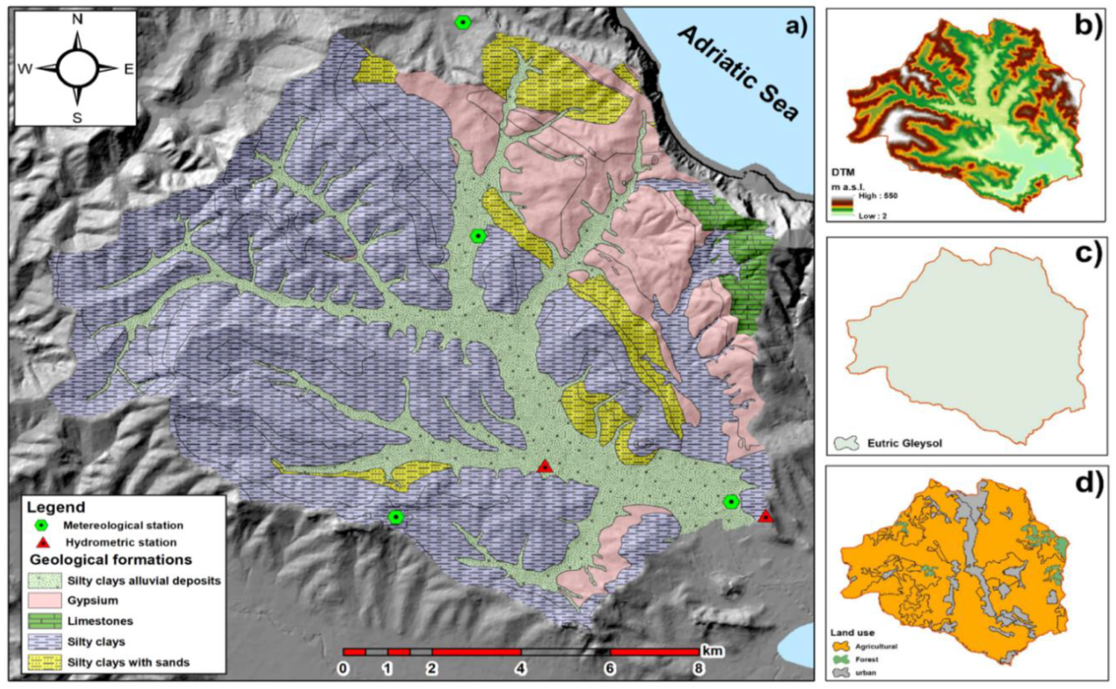
2.1. Study Area

The study area under investigation is the Aspio watershed (Figure 1), located just at South of Ancona town in the Marche region in Italy. It is characterized by a hilly morphology with a smoothed shape (Figure 1b). The Aspio river is the main surface water course of the basin and is a tributary of the Musone river. The geological setting of the Aspio watershed consists of different units (Figure 1a): (i) the Meso-Cenozoic limestone sequence, (ii) the Mio-Plio-Pleistocene sequence made up of marly-clays and marly-clays with sandstone layers, and (iii) the Quaternary continental deposits made up of silty clay, clayey sand and eluvial–colluvial deposits [8]. The eluvial–colluvial covers host a shallow aquifer that contributes to the recharging of the Aspio river and its streams throughout the year. According to the FAO Digital Soil Map of the World classification (DSMW) (Figure 1b), the entire basin is characterized by only one soil category (Eutric Gleysol). Finally, the land use is heterogeneous (Figure 1c) but is mainly dominated by an urban settlement that occupies the central zone of the watershed (Ancona industrial and commercial areas) and agricultural fields located all around.

2.2. SWAT Model

SWAT [9,10] is a physical-based and semi-distributed hydrological model that can operate on a different timescale (daily, monthly and annual), created to model and predict continuous long-time runoff, sediment and agricultural chemical yields with watershed and river-basin scale input data. The model is based on the concept of hydrologic response units (HRUs), and here, a watershed is first divided into multiple sub-watersheds and then further subdivided into HRU which represents portions of a territory characterized by unique land-use/management/soil attributes. Finally, the various outputs of runoff, sediment, and nutrient loadings from each HRU are generated separately using the input of weather, soil properties, topography, vegetation, and land management practices, and finally summarized to determine the total loadings from each sub-basin. The robustness of the applied methodology can be defined by means of different indices: the coefficient of determination (R2), Nash–Sutcliffe efficiency (NSE) and percent of bias (PBIAS) were applied in this study.

3. Results and Discussion

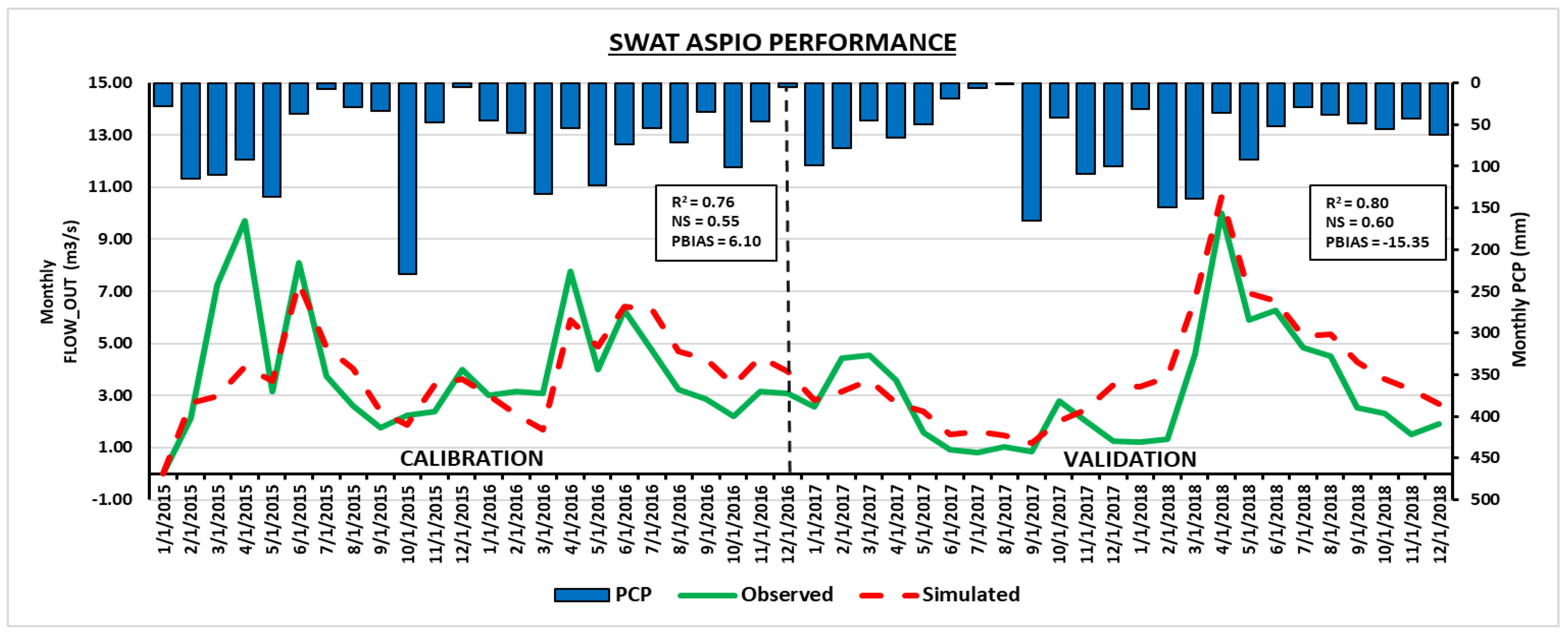
3.1. SWAT Model Calibration and Validation Procedure

The SWAT model for the Aspio basin was built in ArcSWAT 2012 version on ArcGIS 10.2 using different information: (i) morphology, (ii) land cover, (iii) soil properties and (iv) climate data. All the available data were merged in SWAT via three main steps. First, with the “Watershed automatic delimitation”, the topographical inputs were calculated starting from a 20 × 20 m resolution Digital Elevation Model (DEM) to define the watershed features like boundaries, river network, sub-basins, and to derive slope-related parameters. In this case, an area of 155 km2 was divided into 33 sub-basins. In the second phase, the total number of HRU is defined, intersecting the data of slope, land cover and soil property information. The Corine Land Cover (CLC) map for 2018 was used for HRU delimitation. Eleven land covers were identified (mainly industrial, residential, agricultural and agro-forestry) and homogenized with SWAT2012 crop’s default database. Regarding soil properties, the characteristics of soil, like hydraulic conductivity (Ks), soil water content, texture, percentage of organic carbon, soil albedo and more, were used for the Eutric Gleysol database. Daily precipitation and daily maximum and minimum temperature data from four meteorological stations (Osimo, Ancona, Baraccola, Svarchi) located inside the Aspio basin were used for the simulations. The SWAT-CUP program with the SUFI-2 [11] algorithm was used for the calibration/validation procure. Eleven parameters were identified as the most impacting on streamflow simulation [12,13] and are visible in Table 1.
The NSE index was chosen as an optimization function for the calibration procedure together with PBIAS, and R2 was used in this study to check the model performance. Simulations were calibrated and validated using daily streamflow data from the Scaricalasino hydrometric station for the period 2015–2018. A total of 2000 runs of calibration, divided into four interactions of 500 runs, were performed. After the calibration, an SCS runoff curve (CN2) and effective hydraulic conductivity for the main channel (CH_K2) together with some soil characteristics like soil water content (SOL_AWC), bulk density (SOL_BD), soil evaporation factor and baseflow factor (ALPHA_BF) were identified as the factors that produced the higher impact on streamflow simulation. The final calibration showed a high R2 of 0.76 and a good NS value of 0.65 and the positive value of PBIAS (6.1), while for the validation, the values were: R2 of 0.80, an NSE of 0.60 and a PBIAS of −15.35. Figure 2 shows how the simulated streamflow well matches with real data. The full calibration and validation procedure can be found in Busico et al. [8].

3.2. Sediment Yield Calculation

After the realization of the calibration/validation procedure, the SWAT model was run for the period 2015–2018 in the entire basin. Among the available model’s output, the variable Sediment yield (metric tons/ha) was considered. The transported sediment values in the entire basin for 2015, 2016, 2017, 2018 were 1.19, 3.86, 2.15 and 6.06 t/ha, respectively (Figure 3a). The highest values for 2016 and 2018 are due to extreme events that were registered in these years, increasing the annual runoff and directly influencing the sediment transport (Figure 3c). Moreover, in the last few years, small and highly urbanized watersheds, such as Aspio basin, characterized by very short runoff residence time, could be subjected by severe flooding risks [14]. Figure 3b shows the land use contribution to the sediment transport over the entire basin. Here, it is shown that more than 60.0% of the eroded soil comes from agricultural fields, followed by urban areas (29.6%). The lower values, instead, correspond to the forest field where usually less runoff occurs compared to the urban settlement and agricultural fields [15]. This is much more impressive if a normalization with respect to the area occupied by each land use is performed; in fact, the urban area occupies less than 4.5% of the watershed, thus its relative contribution becomes 40% with respect to the other land uses. In fact, urban areas have been recognized, for many years, as contributors of sediment yield mainly through stream channel erosion and infill development [16], and more recently it has been pointed out that the impact of urbanization on the sediment yields of urban watersheds is poorly understood [17] and needs further refined modelling approaches to be completely unraveled.

4. Conclusions

The SWAT model was calibrated and validated using streamflow data in the Aspio basin. All the statistical indices fall within the interval of an excellent calibration, assessing the reliability of SWAT in simulating the streamflow regime. As a result, a general overview of the transported sediment was reported. A direct correlation between streamflow and sediment peaks was observed. In particular, it was stated how the agricultural fields are the main responsible aspects of sediment transport, followed by urban settlement. Usually, urban areas are characterized by a high runoff value but low sediment transport, but in these cases, due to the high urban extension, they give a huge contribution to the sediment transport in the basin. The elaboration proposed here represents a valuable tool for managing implementation plans and preventive targeted actions for those areas more susceptible to runoff generation, like small watersheds characterized by a Mediterranean climate and high anthropization that could be further influenced by climate variation effects.

Author Contributions

Conceptualization, G.B., N.C. and M.M.; methodology, G.B. and N.C.; software, G.B.; validation, G.B., N.C. and M.M.; formal analysis, G.B., N.C. and M.M.; investigation, D.F. and A.T.; resources, M.M. and A.T.; data curation, N.C. and G.B.; writing—original draft preparation, G.B.; writing—review and editing, N.C. and M.M.; supervision, M.M. All authors have read and agree to the published version of the manuscript.

Funding

This research did not receive any funding.

Conflicts of Interest

The authors declare no conflict of interest. The founding sponsors had no role in the design of the study; in the collection, analyses, or interpretation of data; in the writing of the manuscript, and in the decision to publish the results.

References

  1. Aryal, A.; Shrestha, S.; Babel, M.S. Quantifying the sources of uncertainty in an ensemble of hydrological climate-impact projections. Theor. Appl. Climatol. 2019, 135, 193–209. [Google Scholar]
  2. Neitsch, S.L.; Arnold, J.G.; Kiniry, J.R.; Williams, J.R. Soil and Water Assessment Tool (SWAT) Theoretical Documentation; Blackland Research Center, Texas Agricultural Experiment Station and Grassland, Soil and Water Research Laboratory: Temple, TX, USA, 2005. [Google Scholar]
  3. Ayana, E.K.; Worqlul, A.W.; Steenhuis, T.S. Evaluation of stream water quality data generated from MODIS images in modeling total suspended solid emission to a freshwater lake. Sci. Total Environ. 2015, 523, 170–177. [Google Scholar] [PubMed]
  4. Bhatta, B.; Shrestha, S.; Shrestha, P.K.; Talchabhadel, R. Evaluation and application of a SWAT model to assess the climate change impact on the hydrology of the Himalayan river basin. Catena 2019, 181, 104082. [Google Scholar]
  5. Shadmehri Toosi, A.; Calbimonte, G.H.; Nouri, H.; Alaghmand, S. River basin-scale flood hazard assessment using a modified multi-criteria decision analysis approach: A case study. J. Hydrol. 2019, 574, 660–671. [Google Scholar]
  6. Chaplot, V. Impact of DEM mesh size and soil map scale on SWAT runoff, sediment, and NO3-N loads predictions. J. Hydrol. 2005, 312, 207–222. [Google Scholar]
  7. Tazioli, A.; Mattioli, A.; Nanni, T.; Vivalda, P.M. Natural Hazard Analysis in the Aspio Equipped Basin. Engineering Geology for Society and Territory—Volume 3: River Basins, Reservoir Sedimentation and Water Resources; Springer International Publishing: Cham, Switzerland, 2015; pp. 431–435. [Google Scholar]
  8. Busico, G.; Colombani, N.; Fronzi, D.; Pellegrini, M.; Tazioli, A.; Mastrocicco, M. Evaluating SWAT performance to quantify runoff susceptibility in a highly urbanized basin. J. Environ. Manag. 2019, 266, 110625. [Google Scholar]
  9. Arnold, J.G.; Moriasi, D.N.; Gassman, P.W.; Abbaspour, K.C.; White, M.J.; Srinivasan, R.; Santhi, C.; Harmel, R.D.; Griensven, A.; Van-Liew, M.W.; et al. SWAT: Model use, calibration, and validation. Am. Soc. Agric. Biol. Eng. 2012, 55, 1491–1508. [Google Scholar]
  10. Arnold, J.G.; Srinivasan, R.; Muttiah, R.S.; Williams, J.R. Large-area hydrologic modeling and assessment: Part I. Model development. J. Am. Water Resour. 1998, 34, 73–89. [Google Scholar] [CrossRef]
  11. Abbaspour, K.C. Calibration and Uncertainty Programs. In SWAT-Cup User Manual; Eawag Swiss: Dübendorf, Switzerland, 2015. [Google Scholar]
  12. Chen, Y.; Xu, C.-Y.; Chen, X.; Xu, Y.; Yin, Y.; Gao, L.; Liu, M. Uncertainty in simulation of land-use change impacts on catchment runoff with multi-timescales based on the comparison of the HSPF and SWAT models. J. Hydrol. 2019, 573, 486–500. [Google Scholar] [CrossRef]
  13. Khelifa, W.B.; Hermassi, T.; Strohmeier, S.; Zucca, C.; Ziadat, F.; Boufaroua, M.; Habaieb, H. Parameterization of the effect of bench terraces on runoff and sediment yield by swat modeling in a small semi-arid watershed in northern Tunisia. Land Degrad. Dev. 2017, 28, 1568–1578. [Google Scholar] [CrossRef]
  14. Pappenberger, F.; Beven, K.J.; Hunter, N.M.; Bates, P.D.; Gouweleeuw, B.T.; Thielen, J.; de Roo, A.P.J. Cascading model uncertainty from medium range weather forecasts (10 days) through a rainfall-runoff model to flood inundation predictions within the European Flood Forecasting System (EFFS). Hydrol. Earth Syst. Sci. 2015, 9, 381–393. [Google Scholar] [CrossRef]
  15. Ferreira, C.S.S.; Walsh, R.P.D.; Steenhuis, T.S.; Shakesby, R.A.; Nunes, J.P.N.; Coelho, C.O.A.; Ferreira, A.J.D. Spatiotemporal variability of hydrologic soil properties and the implications for overland flow and land management in a peri-urban Mediterranean catchment. J. Hydrol. 2015, 525, 249–263. [Google Scholar] [CrossRef]
  16. Trimble, S.W. Contribution of stream channel erosion to sediment yield from an urbanizing watershed. Science 1997, 278, 1442–1444. [Google Scholar] [PubMed]
  17. Russell, K.L.; Vietz, G.J.; Fletcher, T.D. Global sediment yields from urban and urbanizing watersheds. Earth Sci. Rev. 2017, 168, 73–80. [Google Scholar] [CrossRef]
Figure 1. Representation of the main characteristics of the Aspio basin: (a) geology formation, (b) morphology, (c) FAO Digital World Soil Map classification, (d) CLC 2018 classification.
Environsciproc 02 00005 g001
Figure 2. Soil and Water Assessment Tool (SWAT) calibration/validation procedure.
Environsciproc 02 00005 g002
Figure 3. (a) values of annual sediment transport in the entire basin for the simulated years, (b) land use contribution to the sediment transport where AGRL is agricultural, URB is urban, FRS is forest, GRAP is vineyard and PAST is pasture, (c) sediment yield at the closing station of the basin (see Figure 1).
Environsciproc 02 00005 g003
Table 1. List of parameters used for model calibration.
Parameter NameDescriptionMethodMin ValueMax Value
CH_N2.rteMain channel Manning numberRelative00.3
CH_K2.rteEffective hydraulic conductivityReplace5130
ALPHA_BF.gwBaseflow alpha factorReplace01
SOL_AWC.solAvailable water capacity of the soilRelative−0.20.4
ESCO.hruSoil evaporation compensation factorReplace0.81
SOL_BD.solMoist Bulk densityRelative−0.50.6
GW_REVAP.gwGroundwater evaporation coefficientReplace00.2
ALPHA_BNK.rteBaseflow alpha factor for bank storageReplace01
SOL_K.solSaturated hydraulic conductivityRelative−0.80.8
GW_DELAY.gwGroundwater delay timeReplace30450
CH_N2.rteInitial SCS curve numberReplace00.3
Publisher’s Note: MDPI stays neutral with regard to jurisdictional claims in published maps and institutional affiliations.

