
Wildfires vs. Sustainable Forest Partitioning

 ,
, 
 , , ,
, , ,  and
and 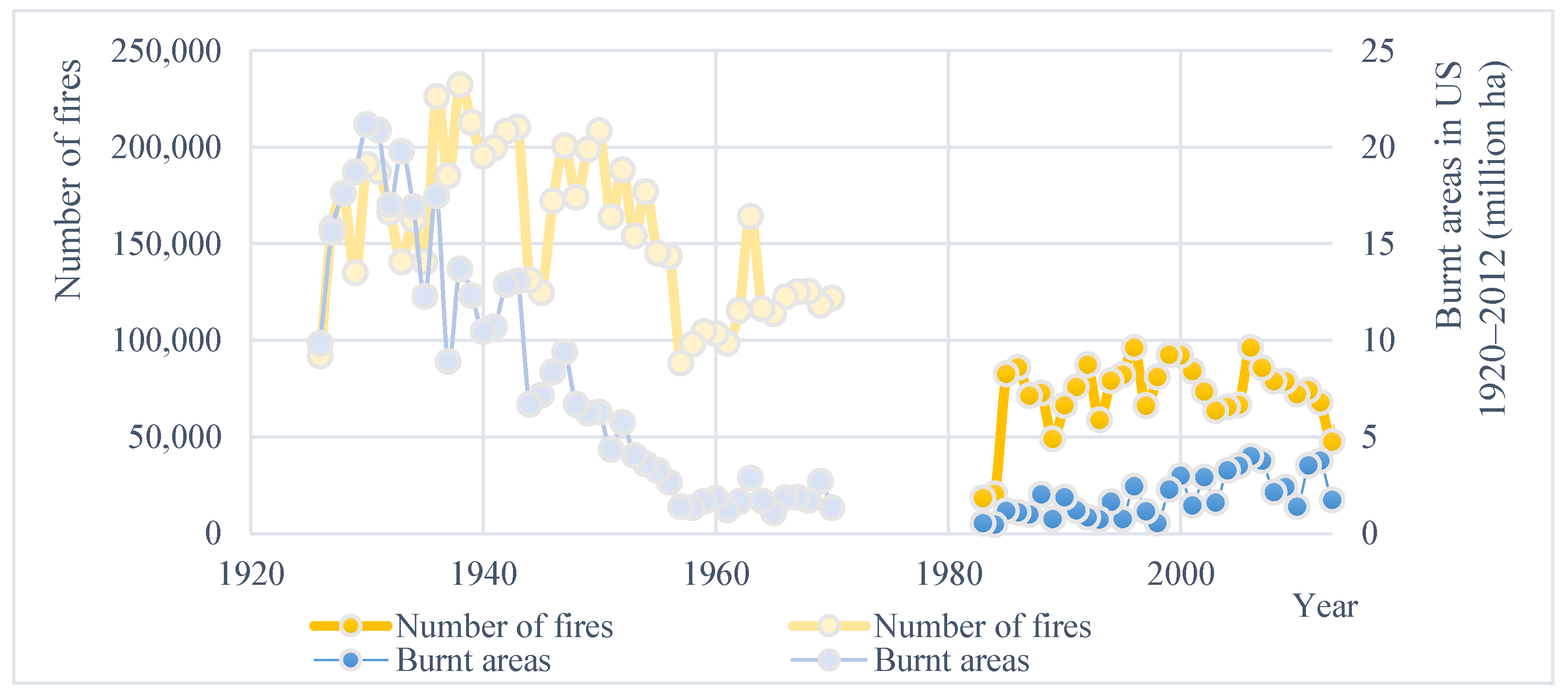
Abstract
:1. Introduction
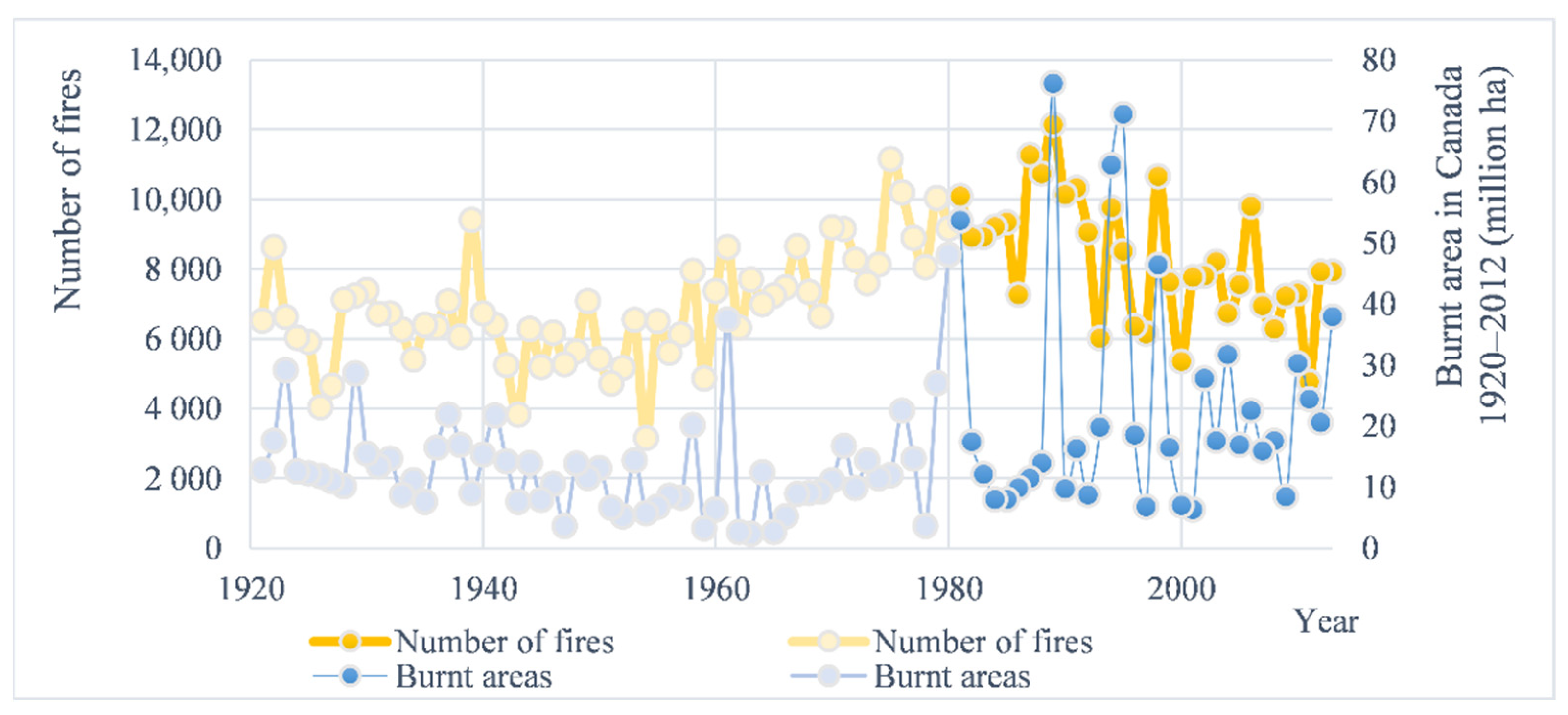
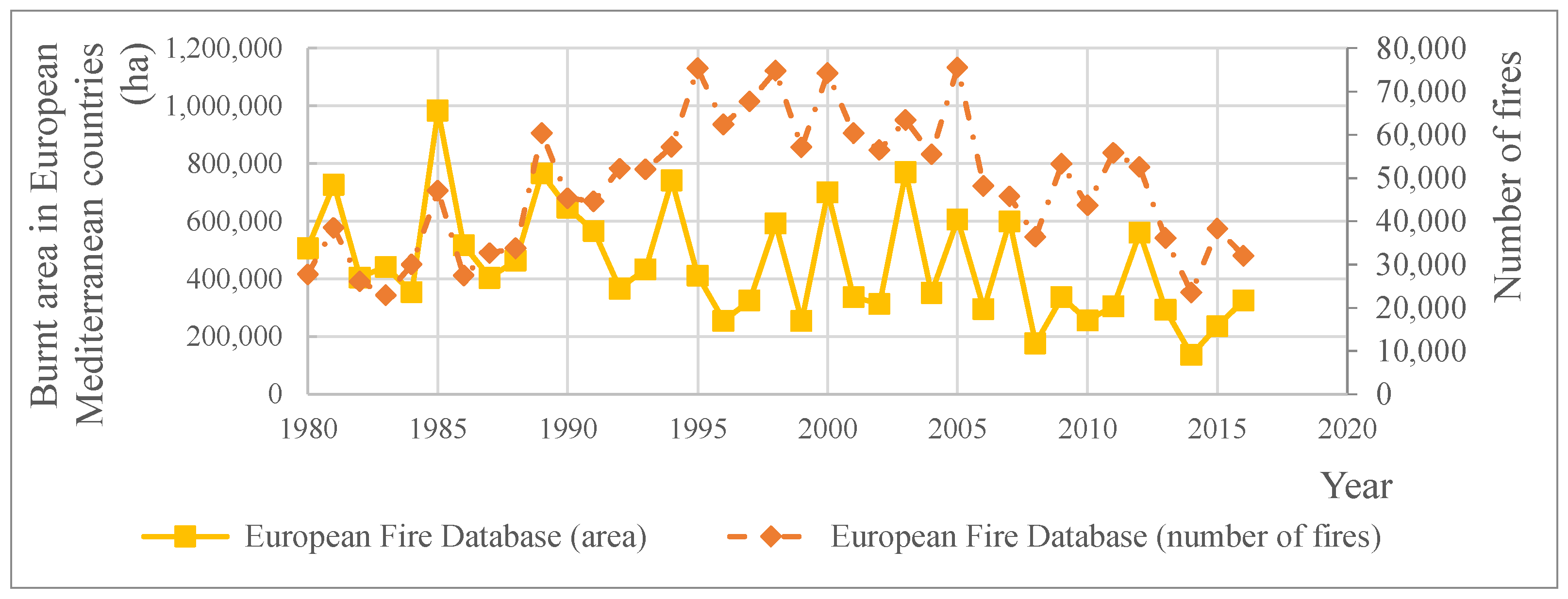
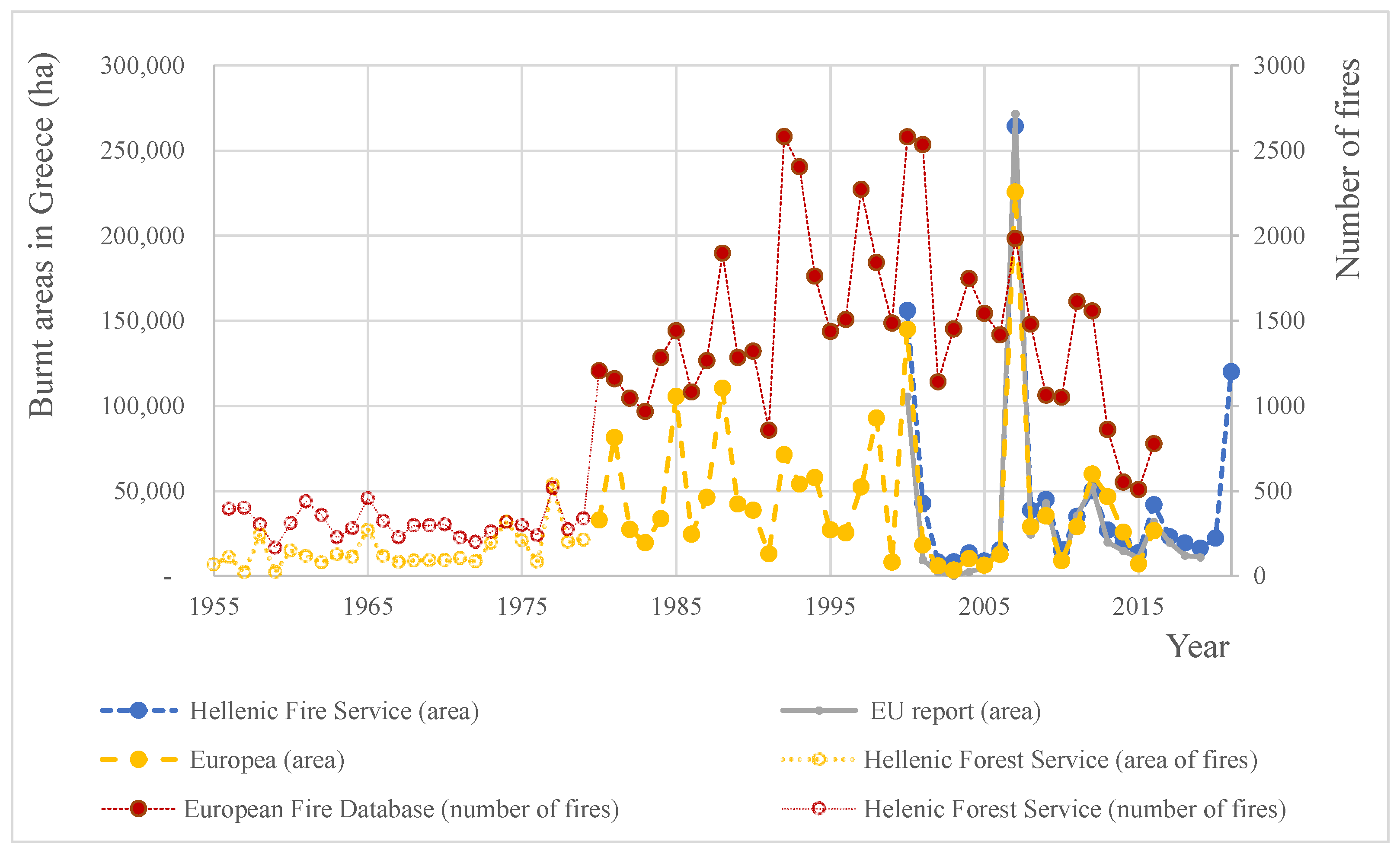
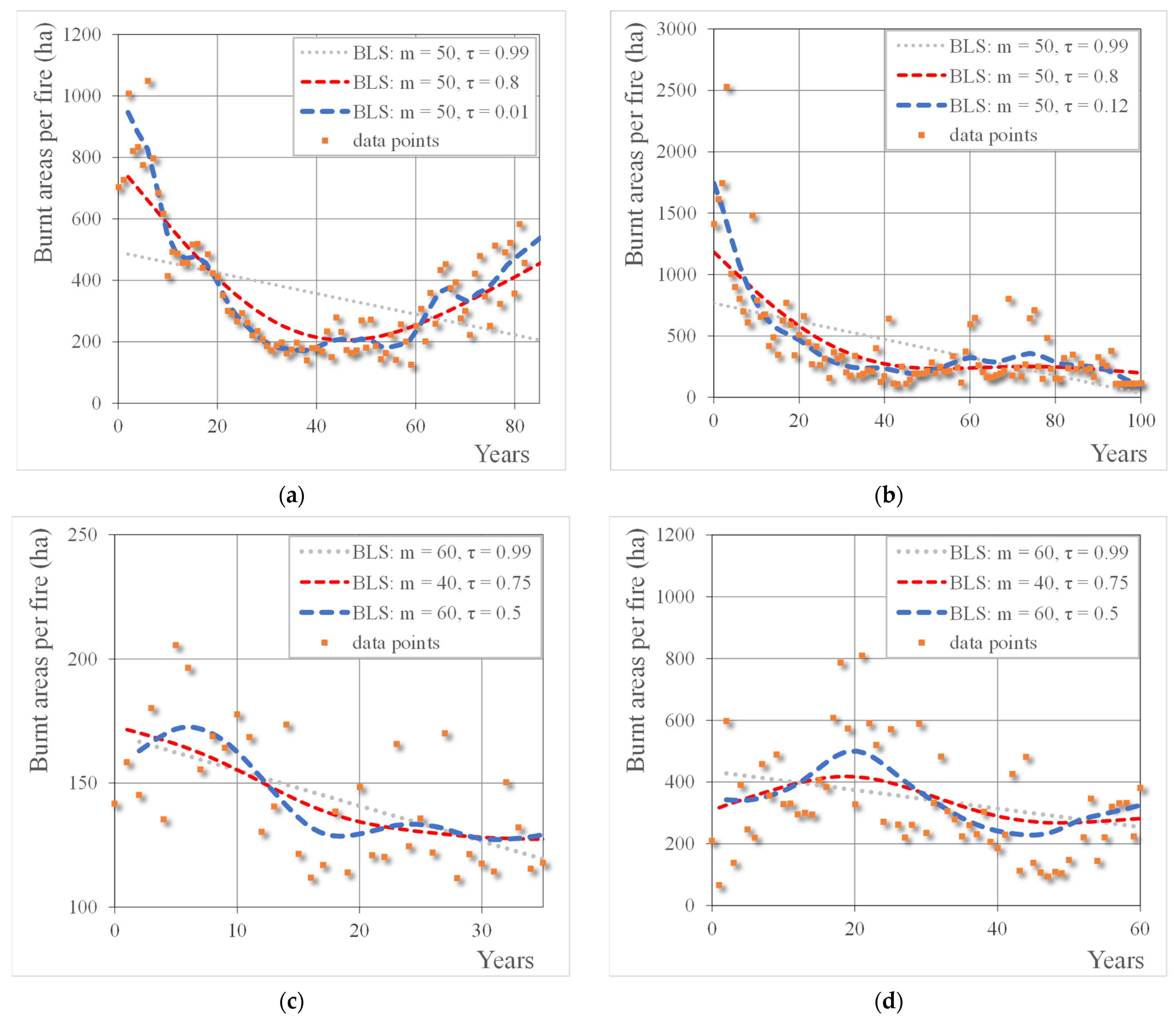
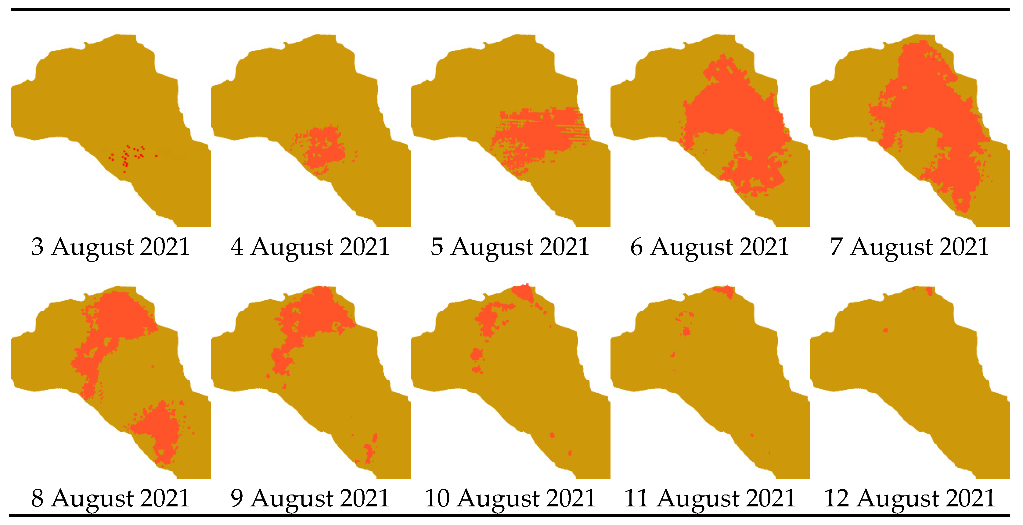
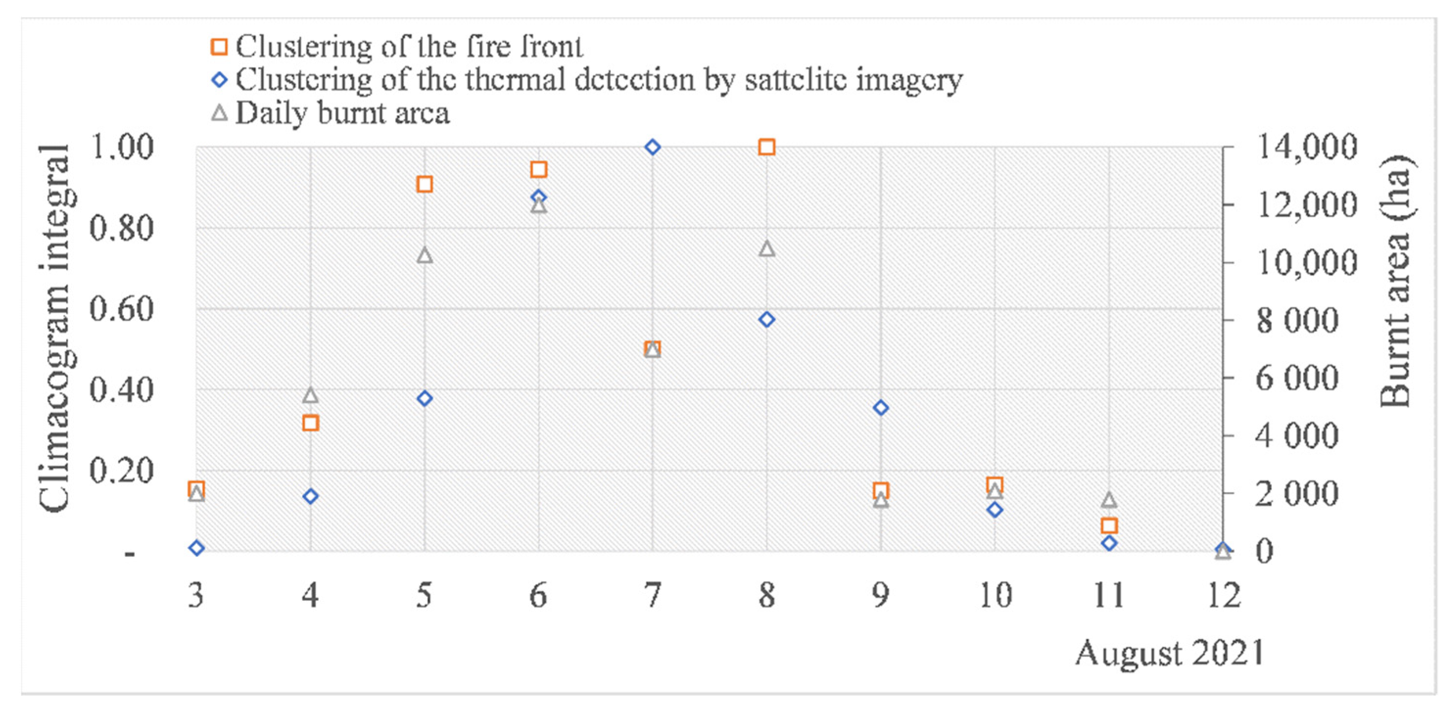
2. Inspecting Time Series of Fires
3. The Event of the Fire
3.1. The Evolution of Fire
3.2. Reactive Methods of Facing Fires
Firefighting aims to stop the running edge of the fire either by constructing a fire break (a line where all burnable material has been removed) or by applying water or a foam mixture to reduce the surface tension of water droplets for easier penetration into the soil or biomass layer (the same principle as used in dish-washing detergent.
3.3. Proactive Methods of Facing Fires
4. The Results of Fire
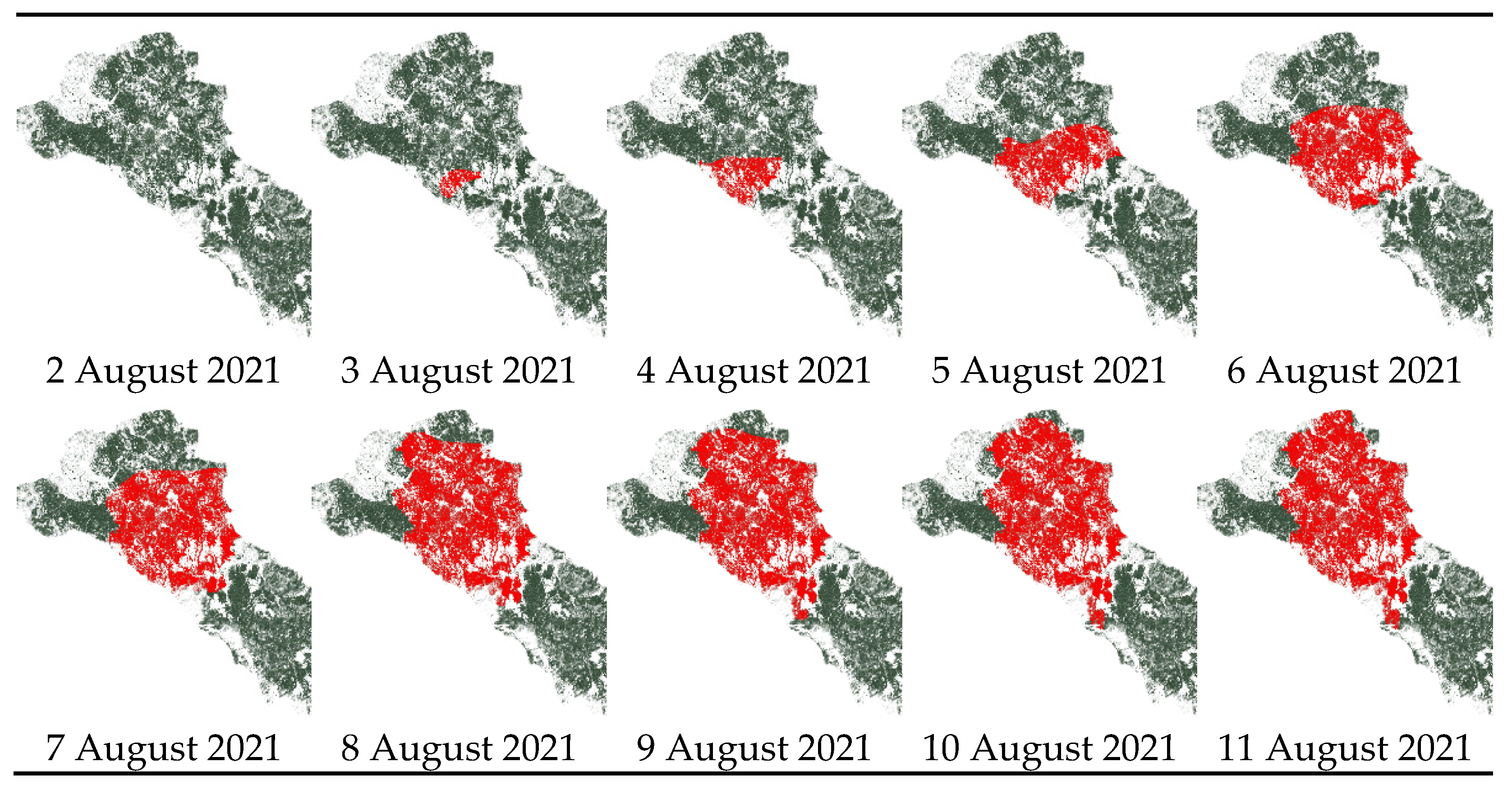
5. Clustering and Growth, Partitioning and Protection
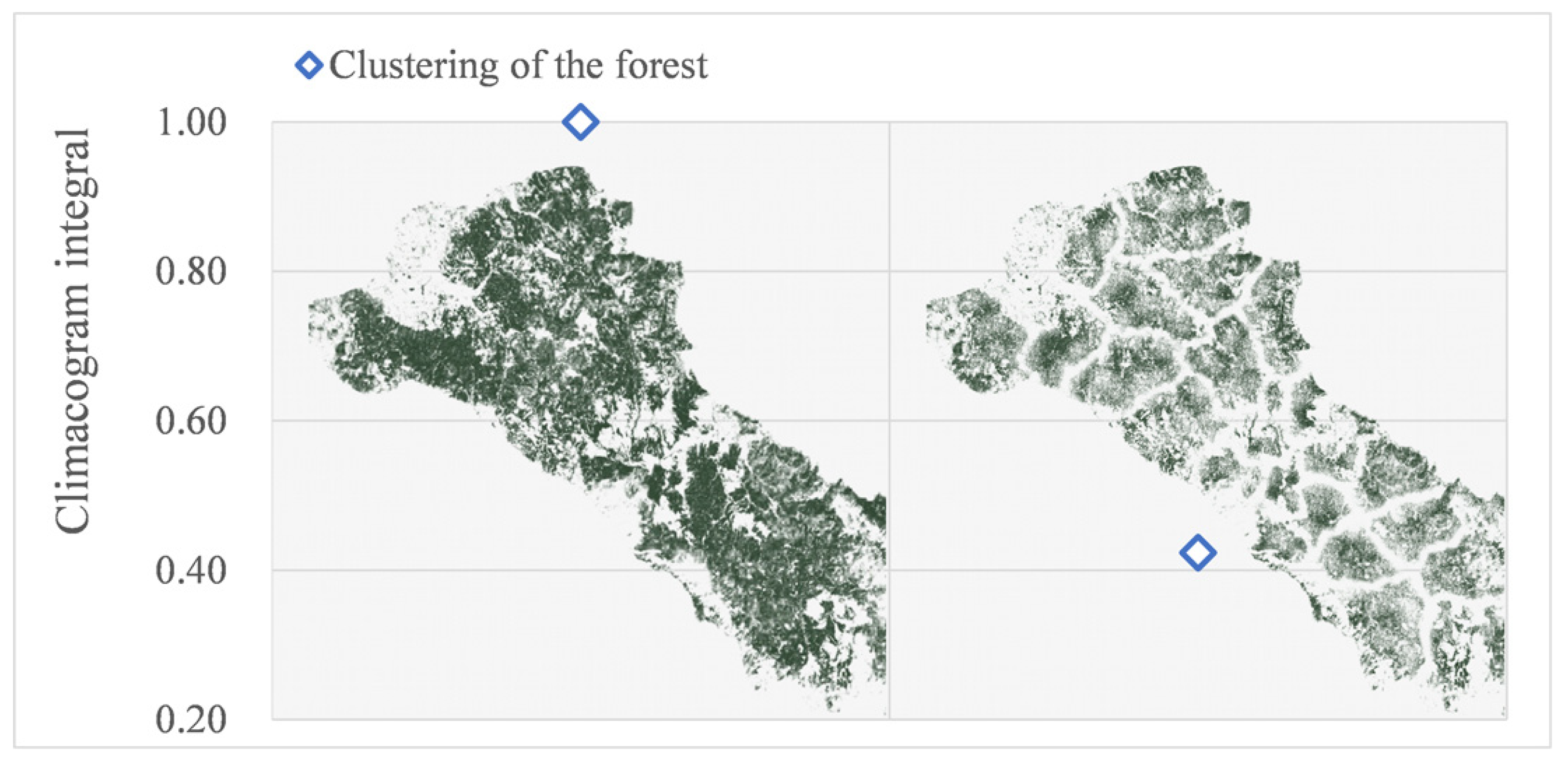
5.1. Quantification of Clustering
5.2. Partitioning and Protection
For most land-cover classes, fire does not occur as expected from a random null model; rather, it behaves selectively, showing marked preference (or avoidance) in terms of fire number and fire size.
From a management perspective, land cover (related to vegetation structure and fuel loads) is the only landscape variable influencing fire behaviour that can be manipulated.
…yields less wood than a tree farm does (that is, young trees, all of about the same age, planted in rows and harvested on a short rotation schedule), but it provides a greater protective cover for the landscape, wood of higher quality, and a home for game birds.
Most of the unburnt surface has one or more of these features: urban, agricultural or agroforestry land use; relatively low population density; flat or undulated terrain; relatively low rainfall.
Humans develop ecological consciousness when they confront the waste they produce.
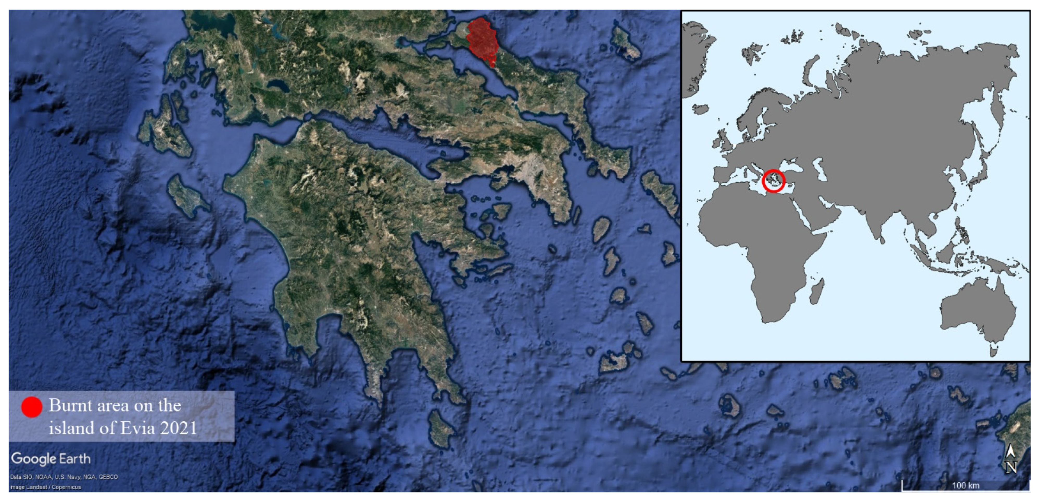
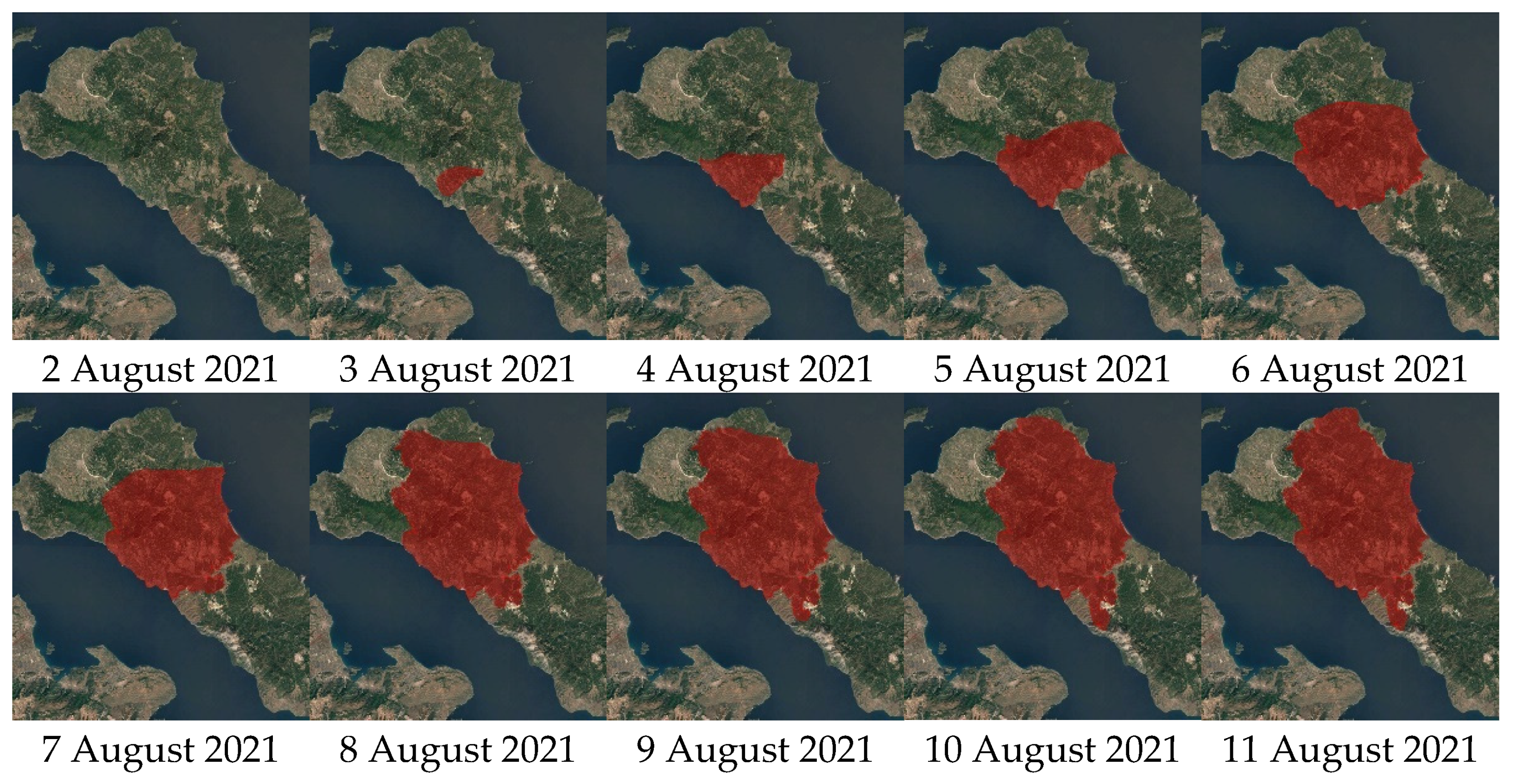
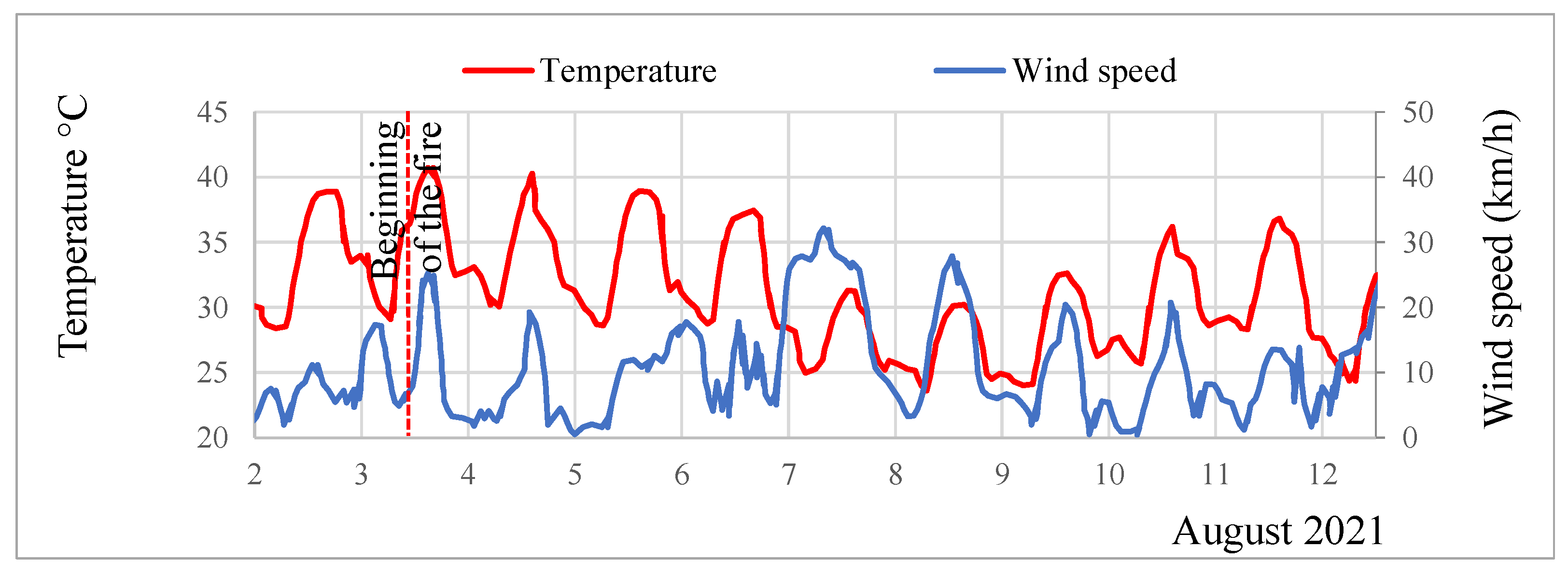
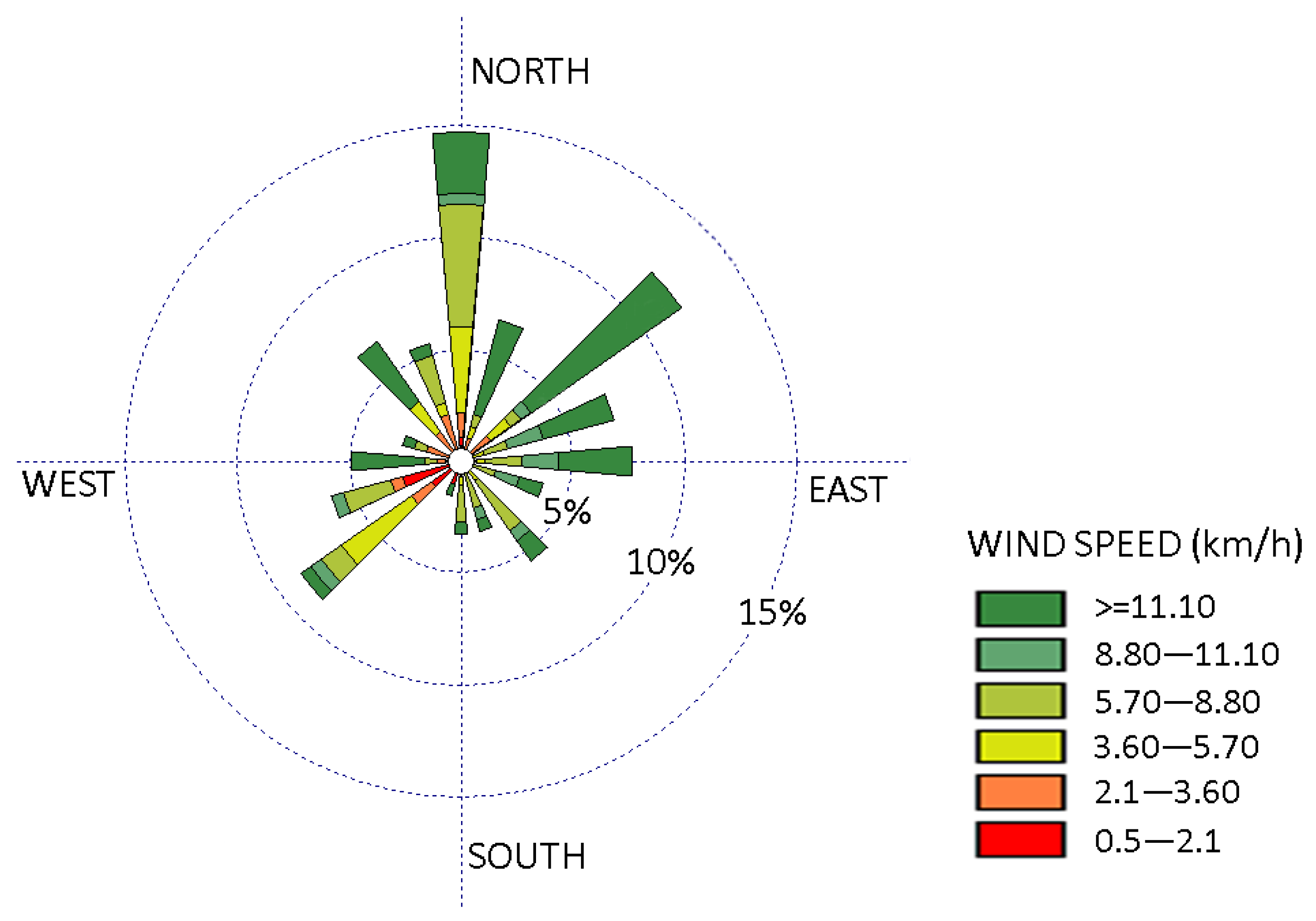
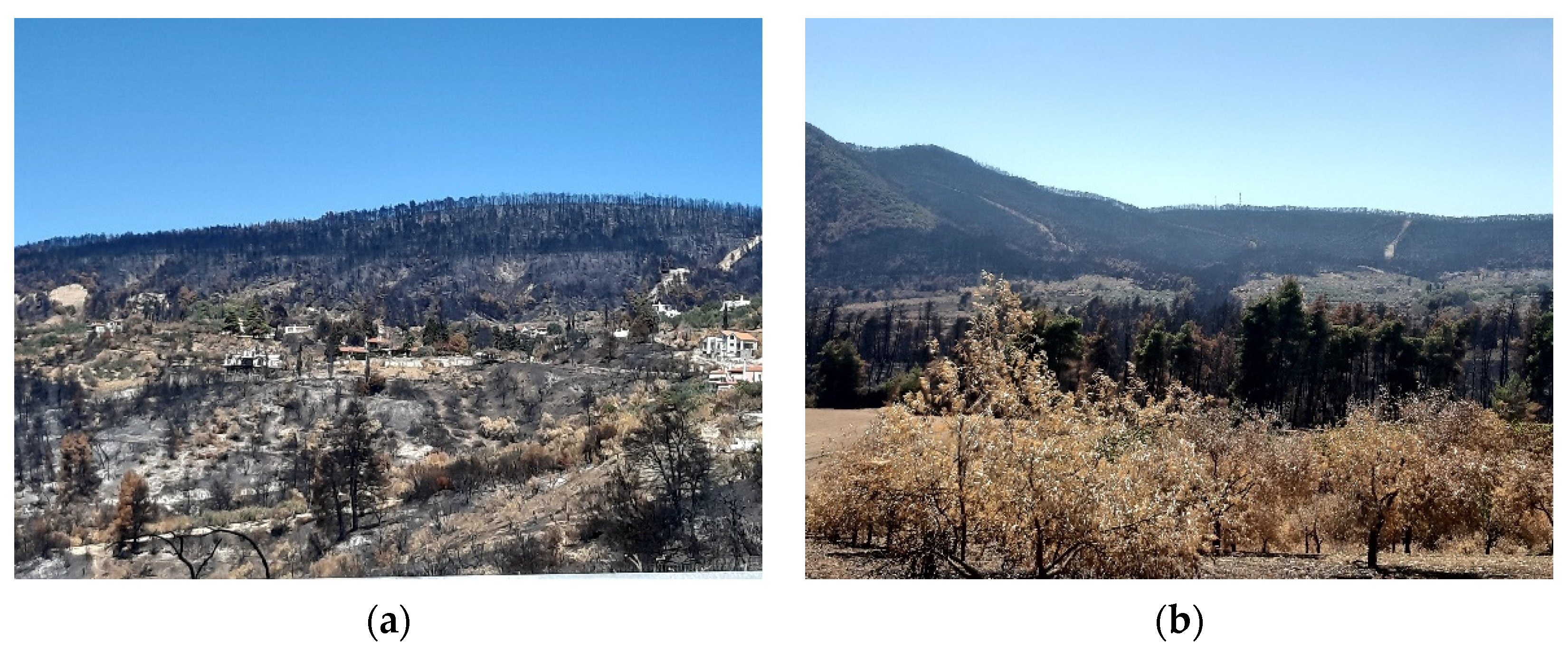
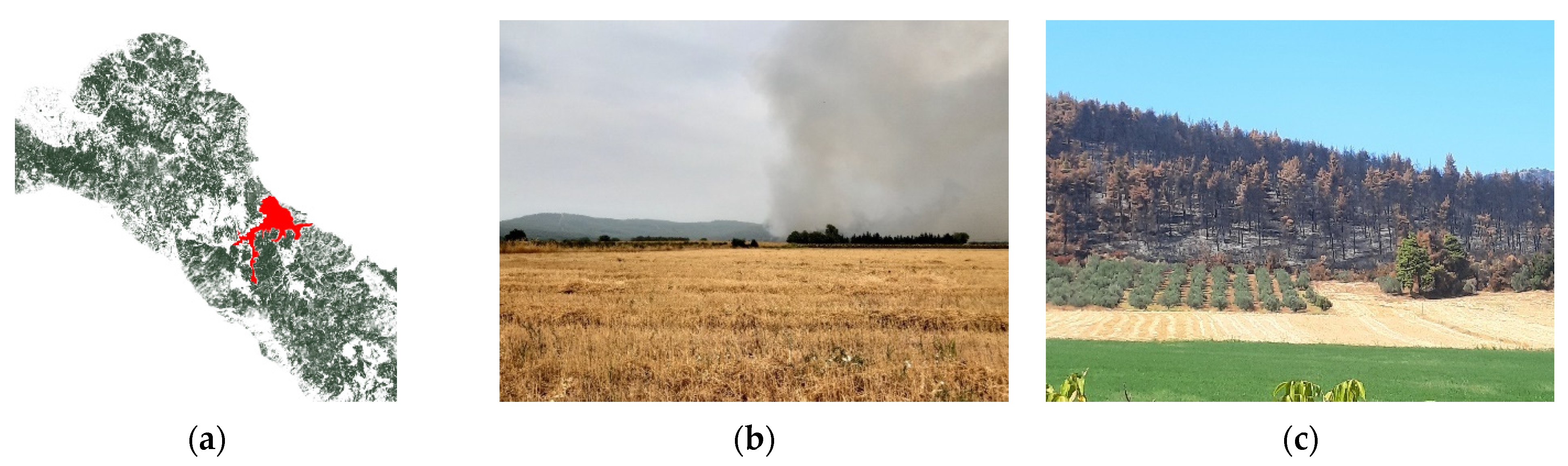
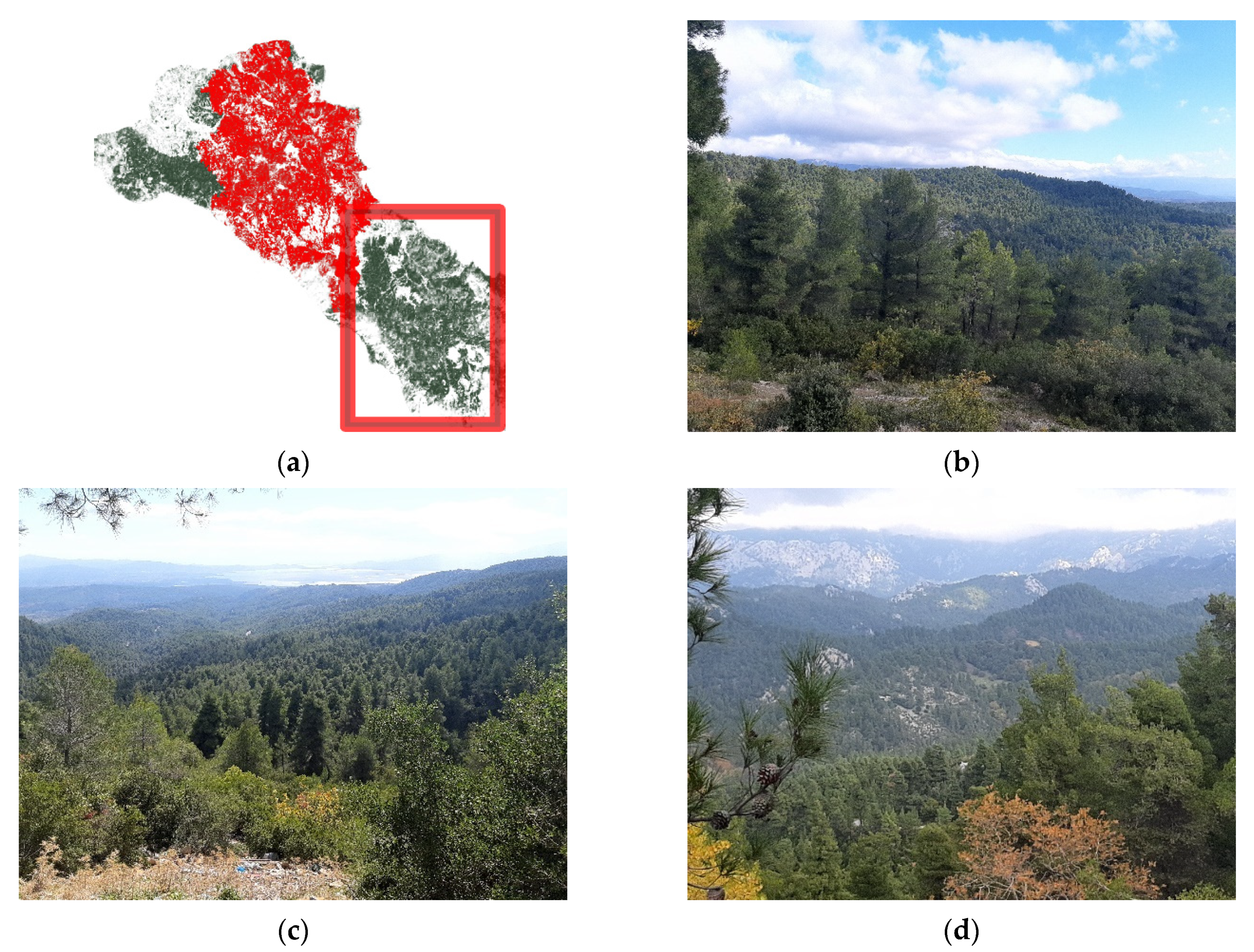
6. Case Study: The Fire in Euboea
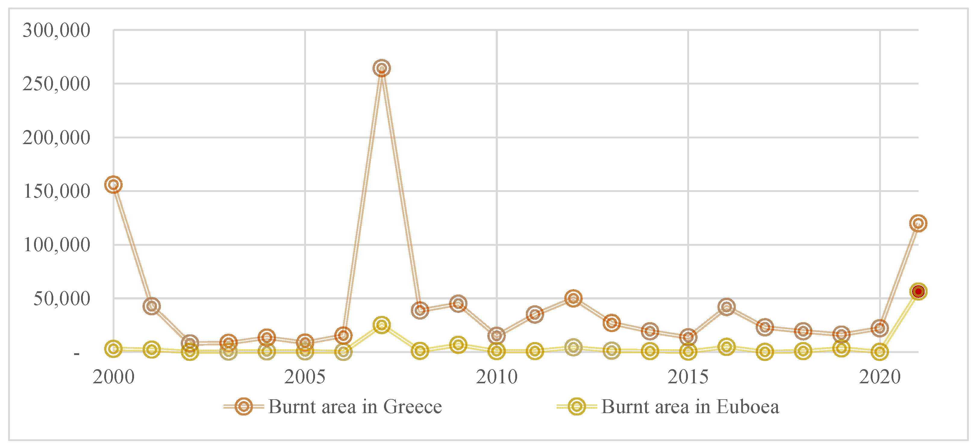
6.1. Inspecting Fires’ Parameters in the Event
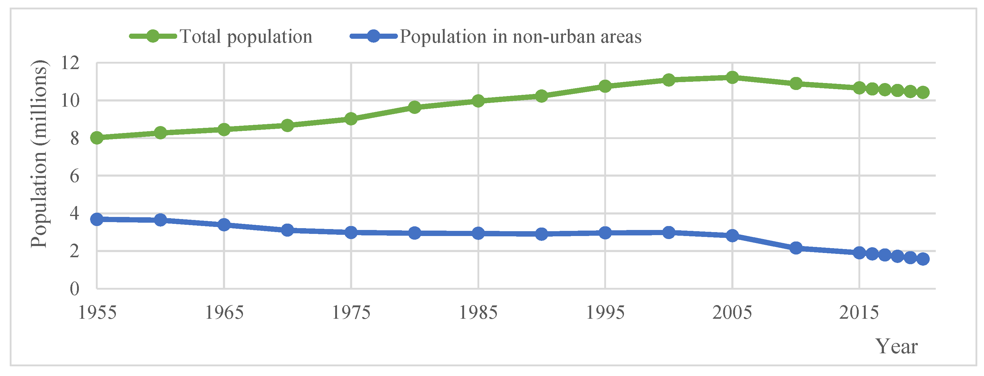
6.2. Local Communities and the Forest
An order forbidden grazing, issued ex officio by the forest service, prohibits the grazing of any animal in an area that has been declared reforestable.
6.3. General Aspects
6.4. Three-Dimensionally Printed Constructions for Cultivation Areas or Corrals
- Fast collection of the material when combining materials with local soil.
- Construction without the need for scaffolding.
- Raw earth is eco-friendly and biodegradable and can produce sustainable constructions. The utilization of renewable materials is necessary nowadays.
- The construction can be inhabited almost immediately.
- Corral, warehouse, or shelter equipment such as sitting benches, workbenches, bed bases, and watering cans could be printed during the process of the printing of partition walls.
7. Discussion
…land abandonment have probably increased fire proneness at national scale by expanding shrub and tree encroachment, and thus increasing fuel connectivity and fuel build-up. Therefore, we urge for a greater integration between fire management and rural development policies.

8. Conclusions
Supplementary Materials
Author Contributions
Funding
Institutional Review Board Statement
Informed Consent Statement
Data Availability Statement
Acknowledgments
Conflicts of Interest
References
- Pyne, S.J. Fire: Nature and Culture; The University of Chicago Press: Chicago, IL, USA, 2013. [Google Scholar]
- Reborn from Ashes: The Alvares Project. Available online: https://www.rsm.nl/cdc/case-catalogue/detail/845-reborn-from-ashes-the-alvares-project/ (accessed on 5 February 2022).
- Climate Change Indicators: Wildfires. Available online: https://www.epa.gov/climate-indicators/climate-change-indicators-wildfires (accessed on 5 February 2022).
- Koutsoyiannis, D. Broken line smoothing: A simple method for interpolating and smoothing data series. Environ. Model. Softw. 2000, 15, 139–149. [Google Scholar] [CrossRef] [Green Version]
- Xanthopoulos, G.; Delogu, G.M.; Leone, V.; Correia, F.J.M.; Magalhães, C.G. Firefighting approaches and extreme wildfires. In Extreme Wildfire Events and Disasters; Tedim, F., Leone, V., McGee, T.K., Eds.; Elsevier Inc.: Amsterdam, The Netherlands, 2020; pp. 117–132. [Google Scholar]
- Ribeiro, L.M.; Viegas, D.X.; Almeida, M.; McGee, T.K.; Pereira, M.G.; Parente, J.; Xanthopoulos, G.; Leone, V.; Delogu, G.M.; Hardin, H. Extreme wildfires and disasters around the world: Lessons to be learned. In Extreme Wildfire Events and Disasters; Tedim, F., Leone, V., McGee, T.K., Eds.; Elsevier Inc.: Amsterdam, The Netherlands, 2020; pp. 31–51. [Google Scholar]
- Moreira, F.; Viedma, O.; Arianoutsou, M.; Curt, T.; Koutsias, N.; Rigolot, E.; Barbati, A.; Corona, P.; Vaz, P.; Xanthopoulos, G. Landscape–wildfire interactions in southern Europe: Implications for landscape management. J. Environ. Manag. 2011, 92, 2389–2402. [Google Scholar] [CrossRef] [PubMed] [Green Version]
- Xanthopoulos, T. Requiem with Crescendo? Homo Sapiens the Ultimate Genus of Human; National Technical University of Athens: Athens, Greece, 2017; Volume A. (In Greek) [Google Scholar]
- Xanthopoulos, T. End of 15th Century–Beginning of 21st Century. In Requiem with Crescendo? Homo Sapiens the Ultimate Genus of Human; National Technical University of Athens: Athens, Greece, 2020; Volume B. (In Greek) [Google Scholar]
- Xanthopoulos, T. Tracking the Exit in 21st Century. In Requiem with Crescendo? Trapped in the Despotisms and Whirlpools of the Artificial Pangea and Panthalassa; National Technical University of Athens: Athens, Greece, 2020; Volume C. (In Greek) [Google Scholar]
- AR6 Climate Change 2021: The Physical Science Basis. Available online: https://www.ipcc.ch/report/ar6/wg1/ (accessed on 5 February 2022).
- Doerr, S.H.; Santín, C. Global trends in wildfire and its impacts: Perceptions versus realities in a changing world. Biol. Sci. 2016, 371, 20150345. [Google Scholar] [CrossRef] [PubMed]
- Shifting Wildfire Trends and Management Implications for the Wildland Urban Interface in the Twenty-first Century. Available online: https://www.intechopen.com/chapters/72916 (accessed on 5 February 2022).
- DellaSala, D.A. Emergence of a New Climate and Human-Caused Wildfire Era for Western USA Forests. In Reference Module in Earth Systems and Environmental Sciences; Elsevier: Amsterdam, The Netherlands, 2018. [Google Scholar] [CrossRef]
- Jurvélius, M. Health and protection Forest Fires (Prediction, Prevention, Preparedness and Suppression). In Encyclopedia of Forest Sciences; Elsevier: Amsterdam, The Netherlands, 2004; pp. 334–339. [Google Scholar]
- National Interagency Fire Center. Available online: https://www.nifc.gov/sites/default/files/document-media/TotalFires.pdf (accessed on 5 February 2022).
- Forestry and Fisheries. Available online: https://www2.census.gov/library/publications/1975/compendia/hist_stats_colonial-1970/hist_stats_colonial-1970p1-chL.pdf?fbclid=IwAR2aJgVV-ZWfZJbtw9QvAZGo3_ZGxaz74DJdOdmtAvbLV2DUp8H0M5epOwE (accessed on 5 February 2022).
- Field, C.B.; Mortsch, L.D.; Brklacich, M.; Forbes, D.L.; Kovacs, P.; Patz, J.A.; Running, S.W.; Scott, M.J. North America. Climate Change 2007: Impacts, Adaptation and Vulnerability. Contribution of Working Group II to the Fourth Assessment Report of theIntergovernmental Panel on Climate Change; Parry, M.L., Canziani, O.F., Palutikof, J.P., van der Linden, P.J., Hanson, C.E., Eds.; Cambridge University Press: Cambridge, UK, 2007; pp. 617–652. Available online: https://www.ipcc.ch/site/assets/uploads/2018/02/ar4-wg2-chapter14-1.pdf (accessed on 5 February 2022).
- Evaluating Past, Current and Future Forest Fire Load Trends in Canada. Available online: https://www.ccfm.org/wp-content/uploads/2013/08/2-Fire-Load-Trends.pdf (accessed on 5 February 2022).
- San-Miguel-Ayanz, J.; Durrant Houston, T.; Boca, R.; Libertà, G.; Branco, A.; De Rigo, D.; Ferrari, D.; Maianti, P.; Artes Vivancos, T.; Costa, H.; et al. Forest Fires in Europe, Middle East and North Africa 2017, EUR 29318 EN; Publications Office of the European Union: Luxembourg, 2018; ISBN 978-92-79-92832-1. [Google Scholar]
- Hellenic Fire Service Database. Available online: https://www.fireservice.gr/el_GR/synola-dedomenon (accessed on 17 January 2022).
- European Forest Fire Information System (EFFIS) Database. Available online: https://effis.jrc.ec.europa.eu/applications/data-and-services (accessed on 5 February 2022).
- Tsagari, K.; Karetsos, G.; Proutsos, N. Forest Fires in Greece 1983–2008, Institute of Mediteranean Forest Ecosystems, WWF, National Institute of Agriculture Research 2011. Available online: http://www.oikoskopio.gr/pyroskopio/pdfs/pyrkagies-ellada.pdf (accessed on 5 February 2022).
- Cleveland, W.S. Robust locally weighted regression and smoothing scatterplots. J. Am. Stat. Assoc. 1979, 74, 829–836. [Google Scholar] [CrossRef]
- Cleveland, W.S.; McGill, R. The Many Faces of a Scatterplot. J. Am. Stat. Assoc. 1984, 79, 807–822. [Google Scholar] [CrossRef]
- Koutsoyiannis, D. Broken Line Smoothing: A Simple Method for Interpolating and Smoothing Data Series. Excel File with VBA Ccode and Calculations. Available online: http://www.itia.ntua.gr/en/getfile/19/3/documents/BLSmooth1.xls (accessed on 5 February 2022).
- Malamos, N.; Koutsoyiannis, D. Broken line smoothing for data series interpolation by incorporating an explanatory variable with denser observations: Application to soil-water and rainfall data. Hydrol. Sci. J. 2015, 60, 468–481. [Google Scholar] [CrossRef] [Green Version]
- Nunes, A.N. Regional variability and driving forces behind forest fires in Portugal an overview of the last three decades (1980–2009). Appl. Geogr. 2012, 34, 576–586. [Google Scholar] [CrossRef]
- Abbate, A.; Longoni, L.; Ivanov, V.I.; Papini, M. Wildfire Impacts on Slope Stability Triggering in Mountain Areas. Geosciences 2019, 9, 417. [Google Scholar] [CrossRef] [Green Version]
- Yue, C.; Luo, C.; Shu, L.; Shen, Z. A review on wildfire studies in the context of global change. Acta Ecol. Sin. 2020, 40, 385–401. [Google Scholar] [CrossRef]
- San-Miguel-Ayanz, J.; Moreno, J.M.; Camia, A. Analysis of large fires in European Mediterranean landscapes: Lessons learned and perspectives. For. Ecol. Manag. 2013, 294, 11–22. [Google Scholar] [CrossRef]
- Goodman, J.; Robinsonhttps, O. Forest Fires: Are They Worse than in Previous Years? BBC Reality Check. Available online: www.bbc.com/news/world−49515462 (accessed on 5 February 2022).
- DellaSala, D.A.; Hanson, C.T. Large Infrequent Fires Are Essential to Forest Dynamics and Biodiversity in Dry Forests of Western North America. In Reference Module in Earth Systems and Environmental Sciences; Elsevier: Amsterdam, The Netherlands, 2015. [Google Scholar]
- Keeley, J.E. Fire: Encyclopedia of Ecology; Jørgensen, S.E., Fath, B.D., Eds.; Academic Press: Cambridge, MA, USA, 2008; pp. 1557–1564. [Google Scholar]
- Coen, J. Wildfire Weather, Encyclopedia of Atmospheric Sciences; Holton, J.R., Ed.; Academic Press: Cambridge, MA, USA, 2003; pp. 2586–2596. [Google Scholar]
- Rodrigues, A.; Ribeiro, C.; Reis, J.; Sousa, M.; Raposo, J. Wildfires in Northern Portugal: An operational case study in Tabuaço. Proc. Inst. Civ. Eng. Forensic Eng. 2021, 173, 81–94. [Google Scholar] [CrossRef]
- Sharples, J.J.; McRae, R.H.D.; Wilkes, S.R. Wind–terrain effects on the propagation of wildfires in rugged terrain: Fire channelling. Int. J. Wildland Fire 2012, 21, 282–296. [Google Scholar] [CrossRef] [Green Version]
- Barbero, R.; Curt, T.; Ganteaume, A.; Maillé, E.; Jappiot, M.; Bellet, A. Simulating the effects of weather and climate on large wildfires in France. Nat. Hazards Earth Syst. Sci. 2019, 19, 441–454. [Google Scholar] [CrossRef] [Green Version]
- Potter, B.E. Atmospheric Properties Associated With Large Wildfires. Int. J. Wildland Fire 1996, 6, 71–76. [Google Scholar] [CrossRef]
- Fernandes, P.M.; Pacheco, A.P.; Almeida, R.; Claro, J. The role of fire-suppression force in limiting the spread of extremely large forest fires in Portugal. Eur. J. For. Res. 2016, 135, 253–262. [Google Scholar] [CrossRef]
- Ciullo, V.; Rossi, L.; Pieri, A. Experimental Fire Measurement with UAV Multimodal Stereovision. Remote Sens. 2020, 12, 3546. [Google Scholar] [CrossRef]
- Gašparović, G.; Klarin, B.; Grebo, A.; Mladenović, S. New Concept of Firefighting Aerial Support with Autonomous Unmanned Aerial Systems (AUAS); New Trends in Aviation Development (NTAD): Smokovec, Slovakia, 2020; pp. 78–83. [Google Scholar]
- Wildfire Risk Management in the District of Vila Real (Portugal) Proceedings of the Institution of Civil Engineers-Forensic Engineering. Available online: https://0-www-icevirtuallibrary-com.brum.beds.ac.uk/doi/full/10.1680/jfoen.21.00010 (accessed on 5 February 2022).
- Meira Castro, A.C.; Nunes, A.; Sousa, A.; Lourenço, L. Mapping the Causes of Forest Fires in Portugal by Clustering Analysis. Geosciences 2020, 10, 53. [Google Scholar] [CrossRef] [Green Version]
- Fire in Northern Attica: The Fire Crossed the National Road. Available online: https://www.kathimerini.gr/society/561458653/fotia-sti-voreia-attiki-dieschise-tin-ethniki-odo-i-pyrkagia/ (accessed on 5 February 2022).
- Gofas, A. Manual of Forest Protection, Εγχειρίδιο δασοπροστασίας, Giahoudi ed; εδκ. Γιαχούδη: Thessalloniki, Greece, 2008. (In Greek) [Google Scholar]
- Reducing Wildfire Risk in the Wildland-Urban Interface: Policy, Trends, and Solutions, 55. Idaho Law Review. Available online: https://digitalcommons.law.uidaho.edu/idaho-law-review/vol55/iss1/1 (accessed on 2 February 2022).
- National Geographic. Controlled Burning. Available online: https://www.nationalgeographic.org/encyclopedia/controlled-burning/ (accessed on 5 February 2022).
- Dimitriadis, P.; Iliopoulou, T.; Sargentis, G.-F.; Koutsoyiannis, D. Spatial Hurst–Kolmogorov Clustering. Encyclopedia 2021, 1, 77. [Google Scholar] [CrossRef]
- Sargentis, G.-F.; Iliopoulou, T.; Sigourou, S.; Dimitriadis, P.; Koutsoyiannis, D. Evolution of Clustering Quantified by a Stochastic Method—Case Studies on Natural and Human Social Structures. Sustainability 2020, 12, 7972. [Google Scholar] [CrossRef]
- Sargentis, G.-F.; Ioannidis, R.; Karakatsanis, G.; Sigourou, S.; Lagaros, N.D.; Koutsoyiannis, D. The Development of the Athens Water Supply System and Inferences for Optimizing the Scale of Water Infrastructures. Sustainability 2019, 11, 2657. [Google Scholar] [CrossRef] [Green Version]
- Bairaktaris, I. The Scale Issues in Hydroelectric Energy: Many Small Projects or a Large One? Master’s Thesis, National Technical University of Athens, Athens, Greece, November 2020. [Google Scholar]
- Of Mice and Elephants: A Matter of Scale. Science. Available online: http://courses.missouristate.edu/chrisbarnhart/bio121/lab/respiration/of_mice_and_elephants.htm (accessed on 2 February 2022).
- Asian Elephant Nutrition, Energy Expenditure. Available online: https://asianelephantnutrition.wordpress.com/2015/02/25/big-body-lots-of-energy-maintenance/ (accessed on 5 February 2022).
- Bermingham, E.; Thomas, D.; Morris, P.; Hawthorne, A. Energy requirements of adult cats. Br. J. Nutr. 2010, 103, 1083–1093. [Google Scholar] [CrossRef] [PubMed]
- National Research Council (US). Subcommittee on Laboratory Animal Nutrition. Nutrient Requirements of Laboratory Animals, 4th ed.; National Academies Press: Washington, DC, USA, 1995. [Google Scholar]
- Koutsoyiannis, D. Scale of water resources development and sustainability: Small is beautiful, large is great. Hydrol. Sci. J. 2011, 56, 553–575. [Google Scholar] [CrossRef]
- How to survive mass extinction. The Guardian. 20 September 2022. Available online: https://www.theguardian.com/science/lost-worlds/2012/sep/20/dinosaurs-fossils (accessed on 2 February 2022).
- Portugal Wildfire Management in a New Era. Assessing Fire Risks, Resources and Reforms. Available online: https://www.isa.ulisboa.pt/files/cef/pub/articles/2018-04/2018_Portugal_Wildfire_Management_in_a_New_Era_Engish.pdf (accessed on 17 January 2022).
- Arianoutsou, M. Resilience of Mediterranean vegetation to fire: Issues under the global change scenarios. In Proceedings of the MEDECOS XI 2007 Conference, Kings Park and Botanic Garden, Perth, Australia, 2–5 September 2007; pp. 5–7. [Google Scholar]
- Mermoz, M.; Kitzberger, T.; Veblen, T.T. Landscape influences on occurrence and spread of wildfires in patagonian forests and shrublands. Ecology 2005, 86, 2705–2715. [Google Scholar] [CrossRef] [Green Version]
- Syphard, A.D.; Brennan, T.J.; Keeley, J.E. The role of defensible space for residential structure protection during wildfires. Int. J. Wildland Fire 2014, 23, 1165–1175. [Google Scholar] [CrossRef]
- Bajocco, S.; Ricotta, C. Evidence of selective burning in Sardinia (Italy): Which land-cover classes do wildfires prefer? Landsc. Ecol. 2008, 23, 241–248. [Google Scholar] [CrossRef]
- Odum, E.P. The Strategy of Ecosystem Development Science. In The Ecological Design and Planning Reader; Ndubisi, F.O., Ed.; Island Press: London, UK, 2014; Available online: https://0-link-springer-com.brum.beds.ac.uk/content/pdf/10.5822/978-1-61091-491-8.pdf (accessed on 17 January 2022).
- Mateus, P.; Fernandes, P.M. Forest Fires in Portugal: Dynamics, Causes and Policies. In Forest Context and Policies in Portugal. World Forests; Reboredo, F., Ed.; Springer: Cham, Switzerland, 2014. [Google Scholar]
- Sargentis, G.-F.; Siamparina, P.; Sakki, G.-K.; Efstratiadis, A.; Chiotinis, M.; Koutsoyiannis, D. Agricultural Land or Photovoltaic Parks? The Water–Energy–Food Nexus and Land Development Perspectives in the Thessaly Plain, Greece. Sustainability 2021, 13, 8935. [Google Scholar] [CrossRef]
- Sargentis, G.-F.; Dimitriadis, P.; Ioannidis, R.; Iliopoulou, T.; Koutsoyiannis, D. Stochastic Evaluation of Landscapes Transformed by Renewable Energy Installations and Civil Works. Energies 2019, 12, 2817. [Google Scholar] [CrossRef] [Green Version]
- Ioannidis, R.; Koutsoyiannis, D.; Sargentis, G.-F. Landscape design in infrastructure projects-is it an extravagance? A cost-benefit investigation of practices in dams. Landsc. Res. 2022; under publication. [Google Scholar]
- Ioannidis, R.; Koutsoyiannis, D. A Review of Land Use, Visibility and Public Perception of Renewable Energy in the Context of Landscape Impact. Appl. Energy 2020, 276, 115367. [Google Scholar] [CrossRef]
- Castoriadis, K.; Καστοριάδης, Κ. Anthropology and Political Philosophy, Ypsilon ed; Ύψιλον/βιβλία: Athens, Greece, 2001. (In Greek) [Google Scholar]
- Filotis. Data Base for Hellenic Nature. Available online: https://filotis.itia.ntua.gr/biotopes/ (accessed on 5 February 2022).
- Evaluation, Review and Specific Aspects of the Regional Spatial Planning and Sustainable Development of the Region of Central Greece, Lanscape (Aξιολόγηση, αναθεώρηση και εξειδίκευση Π.Π.Χ.Σ.A.A. Περιφέρειας Στερεάς Ελλάδας, Τοπίο) Helenic Republic, Ministry of Environment and Climate Change, Department of Spatial Planning (Ελληνική Δημοκρατία ΥΠΕΚA, Δ/νση Χωροταξίας). February 2014. Available online: https://dimoslevadeon.gr/wp-content/uploads/2015/07/2-topio.pdf (accessed on 5 February 2022).
- Google. Google Earth Pro, Version 7.3.3.7786; Map Publisher: Washington, DC, USA, 2021. [Google Scholar]
- ECI-Engineering Consultants INC. Kremasta Project Report; Technical Report prepared for Public Power Corporation (ΔΕH); ECI-Engineering Consultants INC: Boise, ID, USA, 1974. [Google Scholar]
- Frontpages of the Bigest Newspaper of the World. Available online: https://www.marieclaire.gr/art-lifestyle/body-mind/newsroom/h-kravgi-tis-81chronis-giagias-stin-evvia-protoselido-stis-megaliteres-efimerides-tou-kosmou/ (accessed on 15 October 2021).
- Kontoes, C.; Keramitsoglou, I.; Papoutsis, I.; Sifakis, N.I.; Xofis, P. National Scale Operational Mapping of Burnt Areas as a Tool for the Better Understanding of Contemporary Wildfire Patterns and Regimes. Sensors 2013, 13, 11146–11166. [Google Scholar] [CrossRef] [Green Version]
- Firehub. Available online: http://ocean.space.noa.gr/diachronic_bsm/ (accessed on 15 October 2021).
- EUMETSAT, NASA/NOAA/GSFC/EOSDIS, Suomi-NPPVIRS, NWS/GFS, FIRMS. Available online: https://zoom.earth/ (accessed on 15 October 2021).
- NASA WORLDVIEW. Available online: https://worldview.earthdata.nasa.gov/ (accessed on 15 October 2021).
- 112 Emergency Communications Service: 112 Greece. Available online: https://twitter.com/112Greece (accessed on 15 October 2021).
- Meteorological Data. Available online: https://www.meteoblue.com/ (accessed on 15 October 2021).
- Lakes Software, WRPLOT VIEW Software VERSION 8.0.2. Available online: https://www.weblakes.com/software/freeware/wrplot-view/ (accessed on 2 February 2022).
- February 2021 Greek Cold Wave. Available online: https://en.wikipedia.org/wiki/February_2021_Greek_cold_wave (accessed on 2 February 2021).
- Aspects of the Cold Wave Medea in North Euboea. Available online: https://www.egnomi.gr/article/124067/ritinokalliergites_boreiokentrikis_eyboias_toys_afanise_mideia.html (accessed on 2 February 2021).
- Alteregomedia. Available online: http://premiumarchives.alteregomedia.org/ (accessed on 15 October 2021). (In Greek).
- Georgantzis, V. Personal communication, 2021.
- The Invisible Victims of the Fires-9000 Beehives and Tons of Honey Were Lost. Available online: https://www.meteo24news.gr/2021/08/Ta-afani-thimata-ton-pirkagion-xathikan-enia-xiliades-melisosmini-ke-toni-meliou.html (accessed on 15 October 2021).
- Euboea: 9000 Beehives and 65% of the Pine Honey Were Lost! Available online: https://www.naftemporiki.gr/story/1765769/ (accessed on 15 October 2021).
- We lose up to 10,000 Tons of Pine Honey a Year Due to Fires. Available online: https://www.iefimerida.gr/ellada/hanoyme-10000-tonoys-peykomelo-logo-pyrkagion (accessed on 15 October 2021).
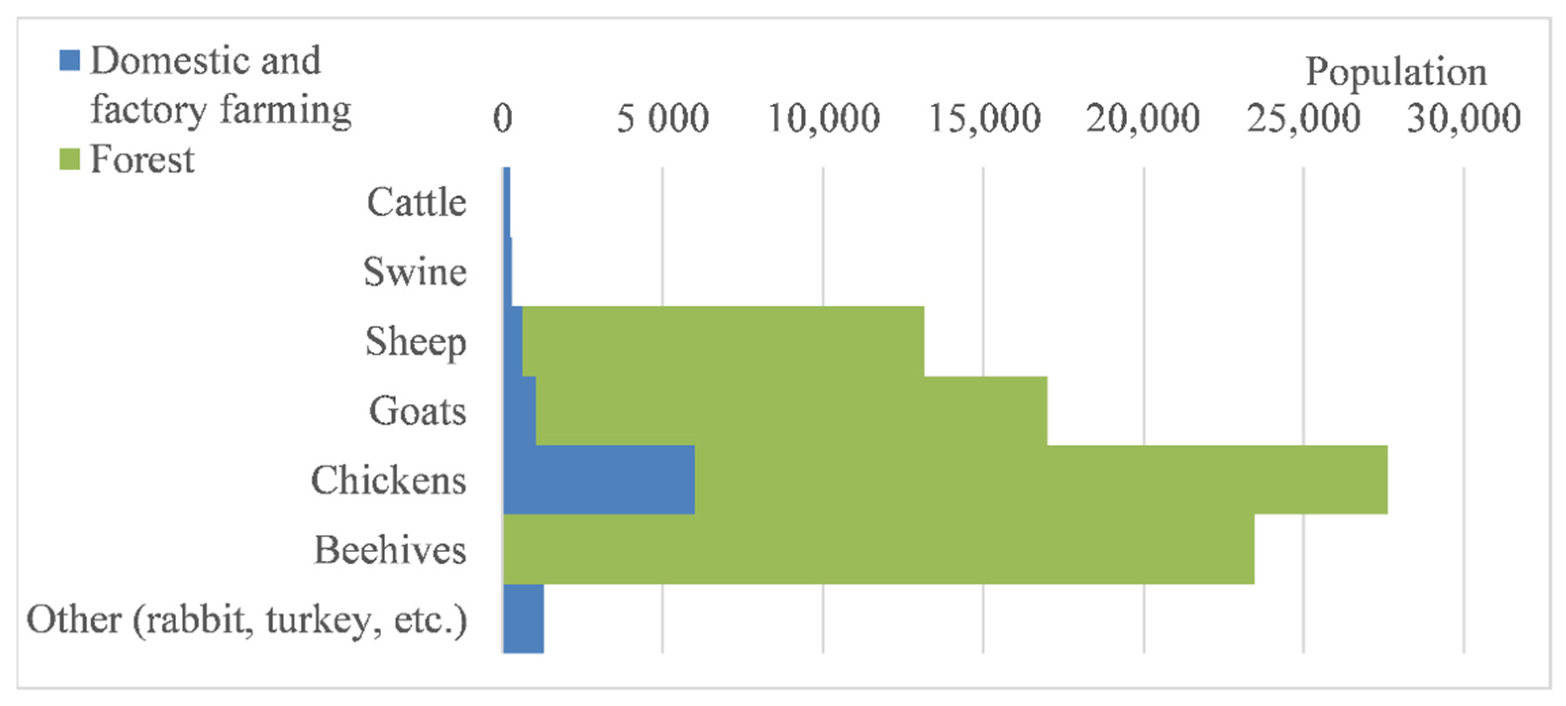
- Hellenic Statistical Authority. Livestock Production in Euboea. Census 2019. Available online: https://www.statistics.gr/en/statistics/-/publication/DKT30/2019-M06 (accessed on 2 February 2022).
- Low 4824/2021. Available online: https://dasarxeio.com/wp-content/uploads/2021/09/n_4824_2021.pdf (accessed on 27 June 2021).
- Mamassis, N.; Efstratiadis, A.; Dimitriadis, P.; Iliopoulou, T.; Ioannidis, R.; Koutsoyiannis, D. Water and Energy. In Handbook of Water Resources Management: Discourses, Concepts and Examples; Bogardi, J.J., Gupta, J., Nandalal, K.D.W., Salamé, L., van Nooijen, R.R.P., Kumar, N., Tingsanchali, T., Bhaduri, A., Kolechkina, A.G., Eds.; Springer International Publishing: Cham, Switzerland, 2021; pp. 619–657. ISBN 978-3-030-60147-8. [Google Scholar]
- Greek Constitution. Available online: https://www.hellenicparliament.gr/Vouli-ton-Ellinon/To-Politevma/Syntagma/ (accessed on 15 October 2021).
- Forest Management. Legislative Decree 86/1969. Available online: http://www.fdparnonas.gr/files/ND86_69.pdf (accessed on 15 October 2021).
- Law 4264/2014. Available online: https://www.kodiko.gr/nomologia/download_fek?f=fek/2014/a/fek_a_118_2014.pdf&t=e518855486f0aa6e8d244d08a282e55f (accessed on 15 October 2021).
- Castro, M.; Fernández-Núñez, E. Seasonal Grazing of Goats and Sheep on Mediterranean Mountainrangelands of Northeast Portugal. Livestock Research for Rural Development. Available online: http://www.lrrd.org/lrrd28/5/cast28091.html (accessed on 15 October 2021).
- den Herder, M.; Helle, S.; Niemelä, P.; Henttonen, H.; Helle, T. Large herbivore grazing limits small mammal densities in Finnish Lapland. Ann. Zool. Fenn. 2016, 53, 154–164. [Google Scholar] [CrossRef]
- Der Herden, M.; Amaral Paulo, J. Sheep as Forest Managers: Management of Young Forest Stands by Grazing Sheep, AFINET (Agroforestry Innovation Networks), Horizon 2020 Nº. 727872. Available online: https://euraf.isa.utl.pt/files/pub/newsletter4_sheep_as_forest_managers_management_of_young_forest_stands_by_grazing_sheep.pdf (accessed on 5 November 2021).
- Managing the Complexities of Land & Livestock. Available online: https://savory.global/holistic-management/ (accessed on 15 October 2021).
- Chandler, C.; Cheney, P.; Thomas, P.; Trabaud, L.; Williams, D. Fire in forestry. In Forest Fire Behavior and Effects. Volume 2. Forest Fire Management and Organization; John Wiley & Sons Inc.: New York, NY, USA, 1983; Volume 1. [Google Scholar]
- Mousourakis, A.; Arakadaki, M.; Kotsopoulos, S.; Sinamidis, I.; Mikrou, T.; Frangedaki, E.; Lagaros, N.D. Earthen Architecture in Greece: Traditional Techniques and Revaluation. Heritage 2020, 3, 68. [Google Scholar] [CrossRef]
- Apostolou, M. The Rehabilitation of the Refugees by Asia Minor Catastrophe: The Role of the Greek State and Foreigners Forces. Bachelor’s Thesis, TEI Kalamatas, Oktober 2007. Available online: http://nestor.teipel.gr/xmlui/bitstream/handle/123456789/12655/SDO_DMYP_00630_Medium.pdf?sequence=1 (accessed on 15 October 2021).
- Marx, K. Capital. A Critique of Political Economy. In Das Kapital: Kritik der politischen Oekonomie; Verlag von Otto Meissner: Hamburg, Germany, 1867. [Google Scholar]
- Sitton, J.F. Critique of the Gotha Programme. In Marx Today; Sitton, J.F., Ed.; Palgrave Macmillan: New York, NY, USA, 2010. [Google Scholar] [CrossRef]
- Keynes, J.M. The General Theory of Employment, Interest and Money; Palgrave Macmillan: London, UK, 1936. [Google Scholar]
- Friedman, M.A. Program for Monetary Stability; Fordham University Press: New York, NY, USA, 1960. [Google Scholar]
- Hayek, F.A. The Constitution of Liberty; University of Chicago Press: Chicago, IL, USA, 1960. [Google Scholar]
- Jackson, T. Prosperity without Growth? The Transition to a Susianable Economy, UK Govement, Sustainable Development Commission. March 2009. Available online: http://www.sd-commission.org.uk/data/files/publications/prosperity_without_growth_report.pdf (accessed on 9 August 2021).
- Latouche, S. The Path to Degrowth for a Sustainable Society. In Factor X. Eco-Efficiency in Industry and Science; Lehmann, H., Ed.; Springer: Cham, Switzerland, 2018; Volume 32, pp. 277–284. [Google Scholar]
- Latouche, S. Degrowth Economics. Le Monde Diplomatique. 2004. Available online: https://www.jussemper.org/Resources/Economic%20Data/Resources/Degrowth%20economics,%20by%20Serge%20Latouche.pdf (accessed on 5 February 2022).
- Galbraith, J.K. Economics in Perspective: A Critical History; Houghton Mifflin: Boston, MA, USA, 1987. [Google Scholar]
- Malthus, T.R. An Essay on the Principle of Population; Johnson, J., Ed.; Pickering & Chatto Publishers: London, UK, 1798. [Google Scholar]
- El-Sayegh, S.R. A Critical Review of 3D Printing in Construction: Benefits, Challenges, and Risks. Archives of Civil and Mechanical Engineering; Springer: Cham, Switzerland, 2020; Volume 20, pp. 1–25. [Google Scholar]
- Media Invited to Final Competition of NASA’s 3D-Printed Habitat Challenge. Available online: https://www.nasa.gov/directorates/spacetech/centennial_challenges/M19-012.html (accessed on 17 January 2022).
- Perrot, A.R. 3D Printing of Earth-Based Materials: Processing Aspects. Construction and Building Materials; Elsevier: Amsterdam, The Netherlands, 2018; Volume 172, pp. 670–676. [Google Scholar]
- Fire Euboea-Deputy Mayor of Mantoudi: 1000 Houses Were Burnt. Available online: https://www.ethnos.gr/greece/article/169611/fotiaeyboiaantidhmarxosmantoydioyeginanstaxth1000spitia (accessed on 15 October 2021).
- Helenic Ministry of Environment and Energy: Simplification of the Procedure for Pruning and Removal of Trees in Private Areas. Available online: https://ypen.gov.gr/aplopoieitai-i-diadikasia-gia-kladefseis-kai-apomakrynseis-dentron-se-idiotikes-ektaseis-ektos-orion-oikismou/ (accessed on 15 October 2021).
- Ascoli, D.; Moris, J.V.; Marchetti, M.; Sallustio, L. Land Use Change towards Forests and Wooded Land Correlates with Large and Frequent Wildfires in Italy. Ann. Silvic. Res. Crea J. 2021, 46. [Google Scholar] [CrossRef]
- Population in Greece. Available online: https://www.worldometers.info/world-population/greece-population/ (accessed on 5 November 2021).
- Koukoumakas, K. The People Who Lived from the Forest. 28 August 2021. Available online: https://www.news247.gr/sunday-edition/eyvoia-oi-anthropoi-poy-zoysan-apo-to-dasos.9335640.html (accessed on 3 February 2021).


Publisher’s Note: MDPI stays neutral with regard to jurisdictional claims in published maps and institutional affiliations. |
© 2022 by the authors. Licensee MDPI, Basel, Switzerland. This article is an open access article distributed under the terms and conditions of the Creative Commons Attribution (CC BY) license (https://creativecommons.org/licenses/by/4.0/).
Share and Cite
Sargentis, G.-F.; Ioannidis, R.; Bairaktaris, I.; Frangedaki, E.; Dimitriadis, P.; Iliopoulou, T.; Koutsoyiannis, D.; Lagaros, N.D. Wildfires vs. Sustainable Forest Partitioning. Conservation 2022, 2, 195-218. https://0-doi-org.brum.beds.ac.uk/10.3390/conservation2010013
Sargentis G-F, Ioannidis R, Bairaktaris I, Frangedaki E, Dimitriadis P, Iliopoulou T, Koutsoyiannis D, Lagaros ND. Wildfires vs. Sustainable Forest Partitioning. Conservation. 2022; 2(1):195-218. https://0-doi-org.brum.beds.ac.uk/10.3390/conservation2010013
Chicago/Turabian StyleSargentis, G.-Fivos, Romanos Ioannidis, Ioannis Bairaktaris, Evangelia Frangedaki, Panayiotis Dimitriadis, Theano Iliopoulou, Demetris Koutsoyiannis, and Nikos D. Lagaros. 2022. "Wildfires vs. Sustainable Forest Partitioning" Conservation 2, no. 1: 195-218. https://0-doi-org.brum.beds.ac.uk/10.3390/conservation2010013