Recent Advances in Smart Mining Technology

A special issue of Applied Sciences (ISSN 2076-3417). This special issue belongs to the section "Energy Science and Technology".

Deadline for manuscript submissions: closed (30 November 2022) | Viewed by 35381
Special Issue Editors


E-Mail Website
Guest Editor
Department of Energy Resources Engineering, Pukyong National University, Busan 48513, Republic of Korea
Interests: smart mining; renewables in mining; space mining; AICBM (AI, IoT, cloud, big data, mobile) convergence; unmanned aerial vehicle; mine planning and design; open-pit mining operation; mine safety; geographic information systems; 3D geo-modeling; geostatistics; hydrological analysis; energy analysis and simulation; design of solar energy conversion systems; renewable energy systems
Special Issues, Collections and Topics in MDPI journals
Department of Energy Resources Engineering, Pukyong National University, Busan 48513, Republic of Korea
Interests: smart mining; digital twins in mining; AICBM (AI, IoT, cloud, big data, mobile) conversion technologies; photovoltaic system; green mobility (e.g., solar-powered electric vehicles); geographic information systems (GIS); spatial analysis; mining simulation; mine safety system
Special Issues, Collections and Topics in MDPI journals

Special Issue Information

The Fourth Industrial Revolution, starting from Industry 4.0 in Germany and the United States, has developed into the concept of an “integrated intelligent society” and is now spreading across all industries. As the core technologies of the Fourth Industrial Revolution, represented by artificial intelligence (AI), Internet of Things (IoT), cloud computing, big data, mobile and wearable devices, augmented/virtual/mixed reality, 3D printing, open source, self-driving, drones, robotics, etc., are fused with domain knowledge by sector, innovative changes are taking place in the industrial field, giving way to a productivity revolution.

This change is also having a significant impact on the mineral industry. The core technologies of the Fourth Industrial Revolution are being introduced and integrated throughout the entire cycle, including exploration, development, production, processing, and environmental restoration of mineral resources. The concept of “smart mining”, which combines traditional mining technology with information and communication technology (ICT), has become a representative keyword representing the Fourth Industrial Revolution of the mineral industry in the age of digital transformation.

This Special Issue (SI) aims to encourage researchers to address recent advances in smart mining technology for the mineral industry. Original research contributions and reviews providing examples of the improvements brought about by smart mining technology in all areas of the mineral sector can be included in this SI.

Prof. Dr. Yosoon Choi
Dr. Jieun Baek
Guest Editor

Manuscript Submission Information

Manuscripts should be submitted online at www.mdpi.com by registering and logging in to this website. Once you are registered, click here to go to the submission form. Manuscripts can be submitted until the deadline. All submissions that pass pre-check are peer-reviewed. Accepted papers will be published continuously in the journal (as soon as accepted) and will be listed together on the special issue website. Research articles, review articles as well as short communications are invited. For planned papers, a title and short abstract (about 100 words) can be sent to the Editorial Office for announcement on this website.

Submitted manuscripts should not have been published previously, nor be under consideration for publication elsewhere (except conference proceedings papers). All manuscripts are thoroughly refereed through a single-blind peer-review process. A guide for authors and other relevant information for submission of manuscripts is available on the Instructions for Authors page. Applied Sciences is an international peer-reviewed open access semimonthly journal published by MDPI.

Please visit the Instructions for Authors page before submitting a manuscript. The Article Processing Charge (APC) for publication in this open access journal is 2400 CHF (Swiss Francs). Submitted papers should be well formatted and use good English. Authors may use MDPI's English editing service prior to publication or during author revisions.

Keywords

  • Artificial intelligence in mining
  • Internet of Things in mining
  • Cloud computing in mining
  • Big data analytics in mining
  • Mobile and wearable devices in mining
  • Augmented, virtual, and mixed realities in mining
  • 3D printing in mining
  • Open-source hardware and software in mining
  • Self-driving and robotics in mining

Published Papers (10 papers)

Order results
Result details
Select all
Export citation of selected articles as:

Editorial

Jump to: Research, Review, Other

3 pages, 163 KiB  
Editorial
Recent Advances in Smart Mining Technology
by Yosoon Choi
Appl. Sci. 2023, 13(6), 3726; https://0-doi-org.brum.beds.ac.uk/10.3390/app13063726 - 15 Mar 2023
Cited by 1 | Viewed by 1713
Abstract
Mining is a crucial industry for our modern society, providing valuable resources that fuel our economies and drive technological progress [...] Full article
(This article belongs to the Special Issue Recent Advances in Smart Mining Technology)

Research

Jump to: Editorial, Review, Other

19 pages, 3345 KiB  
Article
Efficient Machine Learning Models for the Uplift Behavior of Helical Anchors in Dense Sand for Wind Energy Harvesting
by Le Wang, Mengting Wu, Hongzhen Chen, Dongxue Hao, Yinghui Tian and Chongchong Qi
Appl. Sci. 2022, 12(20), 10397; https://0-doi-org.brum.beds.ac.uk/10.3390/app122010397 - 15 Oct 2022
Cited by 2 | Viewed by 1490
Abstract
Helical anchors are widely used in engineering to resist tension, especially during offshore wind energy harvesting, and their uplift behavior in sand is influenced by many factors. Experimental studies are often used to investigate these anchors; however, scale effects are inevitable in 1× [...] Read more.
Helical anchors are widely used in engineering to resist tension, especially during offshore wind energy harvesting, and their uplift behavior in sand is influenced by many factors. Experimental studies are often used to investigate these anchors; however, scale effects are inevitable in 1× g model tests, soil conditions for in situ tests are challenging to control, and centrifuge tests are expensive and rare. To make full use of the limited valid data and to gain more knowledge about the uplift behaviors of helical anchors in sand, a prediction model integrating gradient-boosting decision trees (GBDT) and particle swarm optimization (PSO) was proposed in this study. Data obtained from a series of centrifuge tests formed the dataset of the prediction model. The relative density of soil, embedment ratio, helix spacing ratio, and the number of helices were used as input parameters, while the anchor mobilization distance and the ultimate monotonic uplift resistance were set as output parameters. A GBDT algorithm was used to construct the model, and a PSO algorithm was used for hyperparameter tuning. The results show that the optimal GBDT model accurately predicted the anchor mobilization distance and the ultimate monotonic uplift resistance of helical anchors in dense fine silica sand. By analyzing the relative importance of influencing variables, the embedment ratio was found to be the most significant variable in the model, while the relative density of the fine silica sand soil, the helix spacing ratio, and the number of helices had relatively minor influence. In particular, the helix spacing ratio was found to have no influence on the capacity of adjacent helices when S/D > 6. Full article
(This article belongs to the Special Issue Recent Advances in Smart Mining Technology)
Show Figures

Figure 1

23 pages, 3976 KiB  
Article
Study on the Autonomous Walking of an Underground Definite Route LHD Machine Based on Reinforcement Learning
by Shuo Zhao, Liguan Wang, Ziyu Zhao and Lin Bi
Appl. Sci. 2022, 12(10), 5052; https://0-doi-org.brum.beds.ac.uk/10.3390/app12105052 - 17 May 2022
Cited by 4 | Viewed by 1445
Abstract
The autonomous walking of an underground load-haul-dump (LHD) machine is a current research hotspot. The route of an underground LHD machine is generally definite, and most research is based on the logic of positioning-decision control. Based on a reinforcement learning algorithm, a new [...] Read more.
The autonomous walking of an underground load-haul-dump (LHD) machine is a current research hotspot. The route of an underground LHD machine is generally definite, and most research is based on the logic of positioning-decision control. Based on a reinforcement learning algorithm, a new autonomous walking training algorithm, Traditional Control Based DQN (TCB-DQN), combining the methods of traditional reflective navigation and reinforcement learning deep q-networks (DQN), is proposed. Compared with the logic of location-decision control, TCB-DQN does not require accurate positioning, but only determines how to reach the endpoint by sensing the distance from the endpoint. Through experimental verification, after using the TCB-DQN algorithm for training in a simple tunnel, the LHD machine could achieve a walking effect similar to that of a human driver’s manual operation, while after training in a more complex tunnel, the TCB-DQN algorithm could reach the endpoint smoothly. Full article
(This article belongs to the Special Issue Recent Advances in Smart Mining Technology)
Show Figures

Figure 1

18 pages, 10882 KiB  
Article
Lab Scale Model Experiment of Smart Hopper System to Remove Blockages Using Machine Vision and Collaborative Robot
by Heonmoo Kim and Yosoon Choi
Appl. Sci. 2022, 12(2), 579; https://0-doi-org.brum.beds.ac.uk/10.3390/app12020579 - 07 Jan 2022
Cited by 5 | Viewed by 1603
Abstract
In this study, we propose a smart hopper system that automatically unblocks obstructions caused by rocks dropped into hoppers at mining sites. The proposed system captures RGB (red green blue) and D (depth) images of the upper surfaces of hopper models using an [...] Read more.
In this study, we propose a smart hopper system that automatically unblocks obstructions caused by rocks dropped into hoppers at mining sites. The proposed system captures RGB (red green blue) and D (depth) images of the upper surfaces of hopper models using an RGB-D camera and transmits them to a computer. Then, a virtual hopper system is used to identify rocks via machine vision-based image processing techniques, and an appropriate motion is simulated in a robot arm. Based on the simulation, the robot arm moves to the location of the rock in the real world and removes it from the actual hopper. The recognition accuracy of the proposed model is evaluated in terms of the quantity and location of rocks. The results confirm that rocks are accurately recognized at all positions in the hopper by the proposed system. Full article
(This article belongs to the Special Issue Recent Advances in Smart Mining Technology)
Show Figures

Figure 1

20 pages, 6587 KiB  
Article
Analysis and Diagnosis of Truck Transport Routes in Underground Mines Using Transport Time Data Collected through Bluetooth Beacons and Tablet Computers
by Sebeom Park and Yosoon Choi
Appl. Sci. 2021, 11(10), 4525; https://0-doi-org.brum.beds.ac.uk/10.3390/app11104525 - 15 May 2021
Cited by 4 | Viewed by 1874
Abstract
In this study, we developed a system to collect and analyze log data related to truck travel times in underground mines using Bluetooth beacons and tablet computers. When a signal from beacons installed at a major underground mine is received by a truck-mounted [...] Read more.
In this study, we developed a system to collect and analyze log data related to truck travel times in underground mines using Bluetooth beacons and tablet computers. When a signal from beacons installed at a major underground mine is received by a truck-mounted tablet computer, the beacon information is collected and uploaded to a cloud server. A data processing program integrates the uploaded log data files into a single file, calculating the statistical values for each section of the transport route. The developed system was applied to a limestone underground mine located in Jeongseon, Korea, to diagnose and analyze the transport routes in the study area. As a result of this analysis, it was possible to select sections in which the truck transport time was stable and sections in which it was unstable. Consequently, the transport route could be classified into four types based on the distribution and fluctuations in the truck transport time data. Moreover, it was possible to analyze the causes of the stable and unstable sections through production logs and field staff interviews. The developed system could be used as a tool to improve transport operations by diagnosing and analyzing the truck transport routes of a mine. Full article
(This article belongs to the Special Issue Recent Advances in Smart Mining Technology)
Show Figures

Figure 1

18 pages, 6523 KiB  
Article
Smart Helmet-Based Personnel Proximity Warning System for Improving Underground Mine Safety
by Yeanjae Kim, Jieun Baek and Yosoon Choi
Appl. Sci. 2021, 11(10), 4342; https://0-doi-org.brum.beds.ac.uk/10.3390/app11104342 - 11 May 2021
Cited by 25 | Viewed by 7442
Abstract
A smart helmet-based wearable personnel proximity warning system was developed to prevent collisions between equipment and pedestrians in mines. The smart helmet worn by pedestrians receives signals transmitted by Bluetooth beacons attached to heavy equipment, light vehicles, or dangerous zones, and provides visual [...] Read more.
A smart helmet-based wearable personnel proximity warning system was developed to prevent collisions between equipment and pedestrians in mines. The smart helmet worn by pedestrians receives signals transmitted by Bluetooth beacons attached to heavy equipment, light vehicles, or dangerous zones, and provides visual LED warnings to the pedestrians and operators simultaneously. A performance test of the proposed system was conducted in an underground limestone mine. It was confirmed that as the transmission power of the Bluetooth beacon increased, the Bluetooth low energy (BLE) signal detection distance of the system also increased. The average BLE signal detection distance was at least 10 m, regardless of the facing angle between the smart helmet and Bluetooth beacon. The subjective workload for the smartphone-, smart glasses-, and smart helmet-based proximity warning system (PWS) was evaluated using the National Aeronautics and Space Administration task load index. All six workload parameters were the lowest when using the smart helmet-based PWS. The smart helmet-based PWS can provide visual proximity warning alerts to both the equipment operator and the pedestrian, and it can be expanded to provide worker health monitoring and hazard awareness functions by adding sensors to the Arduino board. Full article
(This article belongs to the Special Issue Recent Advances in Smart Mining Technology)
Show Figures

Figure 1

16 pages, 8118 KiB  
Article
Stochastic Predictions of Ore Production in an Underground Limestone Mine Using Different Probability Density Functions: A Comparative Study Using Big Data from ICT System
by Dahee Jung, Jieun Baek and Yosoon Choi
Appl. Sci. 2021, 11(9), 4301; https://0-doi-org.brum.beds.ac.uk/10.3390/app11094301 - 10 May 2021
Cited by 9 | Viewed by 2205
Abstract
This study stochastically predicted ore production through discrete event simulation using four different probability density functions for truck travel times. An underground limestone mine was selected as the study area. The truck travel time was measured by analyzing the big data acquired from [...] Read more.
This study stochastically predicted ore production through discrete event simulation using four different probability density functions for truck travel times. An underground limestone mine was selected as the study area. The truck travel time was measured by analyzing the big data acquired from information and communications technology (ICT) systems in October 2018, and probability density functions (uniform, triangular, normal, and observed probability distribution of real data) were determined using statistical values. A discrete event simulation model for a truck haulage system was designed, and truck travel times were randomly generated using a Monte Carlo simulation. The ore production that stochastically predicted fifty times for each probability density function was analyzed and represented as a value of lower 10% (P10), 50% (P50), and 90% (P90). Ore production was underestimated when a uniform and triangular distribution was used, as the actual ore production was similar to that of P90. Conversely, the predicted ore production of P50 was relatively consistent with the actual ore production when using the normal and observed probability distribution of real data. The root mean squared error (RMSE) for predicting ore production for ten days in October 2018 was the lowest (24.9 ton/day) when using the observed probability distribution. Full article
(This article belongs to the Special Issue Recent Advances in Smart Mining Technology)
Show Figures

Figure 1

22 pages, 13127 KiB  
Article
A New Challenge: Path Planning for Autonomous Truck of Open-Pit Mines in The Last Transport Section
by Ziyu Zhao and Lin Bi
Appl. Sci. 2020, 10(18), 6622; https://0-doi-org.brum.beds.ac.uk/10.3390/app10186622 - 22 Sep 2020
Cited by 11 | Viewed by 3772
Abstract
During the operation of open-pit mining, the loading position of a haulage truck often changes, bringing a new challenge concerning how to plan an optimal truck transportation path considering the terrain factors. This paper proposes a path planning method based on a high-precision [...] Read more.
During the operation of open-pit mining, the loading position of a haulage truck often changes, bringing a new challenge concerning how to plan an optimal truck transportation path considering the terrain factors. This paper proposes a path planning method based on a high-precision digital map. It contains two parts: (1) constructing a high-precision digital map of the cutting zone and (2) planning the optimal path based on the modified Hybrid A* algorithm. Firstly, we process the high-precision map based on different terrain feature factors to generate the obstacle cost map and surface roughness cost map of the cutting zone. Then, we fuse the two cost maps to generate the final cost map for path planning. Finally, we incorporate the contact cost between tire and ground to improve the node extension and path smoothing part of the Hybrid A* algorithm and further enhance the algorithm’s capability of avoiding the roughness. We use real elevation data with different terrain resolutions to perform random tests and the results show that, compared with the path without considering the terrain factors, the total transportation cost of the optimal path is reduced by 10%–20%. Moreover, the methods demonstrate robustness. Full article
(This article belongs to the Special Issue Recent Advances in Smart Mining Technology)
Show Figures

Figure 1

Review

Jump to: Editorial, Research, Other

35 pages, 6204 KiB  
Review
Applications of the Open-Source Hardware Arduino Platform in the Mining Industry: A Review
by Sung-Min Kim, Yosoon Choi and Jangwon Suh
Appl. Sci. 2020, 10(14), 5018; https://0-doi-org.brum.beds.ac.uk/10.3390/app10145018 - 21 Jul 2020
Cited by 26 | Viewed by 9151
Abstract
In this study, applications of the Arduino platform in the mining industry were reviewed. Arduino, a representative and popular open-source hardware, can acquire information from various sensors, transmit data using communication technology, and control devices through actuators. The review was conducted by classifying [...] Read more.
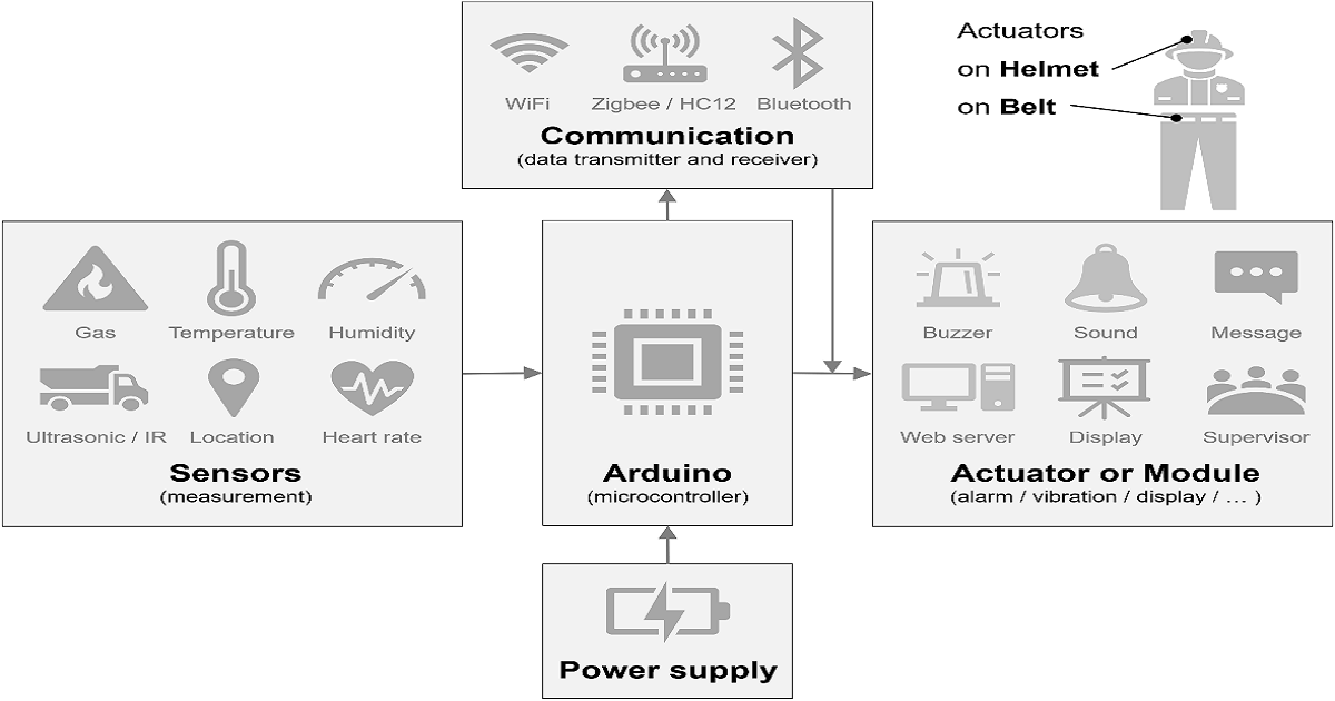
In this study, applications of the Arduino platform in the mining industry were reviewed. Arduino, a representative and popular open-source hardware, can acquire information from various sensors, transmit data using communication technology, and control devices through actuators. The review was conducted by classifying previous studies into three types of Arduino applications: field monitoring systems, wearable systems, and autonomous systems. With regard to field monitoring systems, most studies in mines were classified as atmospheric or geotechnical monitoring. In wearable systems, the health status of the miner was an important consideration, in addition to the environmental conditions of the mine. Arduino can be a useful tool as an initial prototype for autonomous mine systems. Arduino has advantages in that it can be combined with various electronic products and is cost-effective. Therefore, although many studies have been conducted in the laboratory (as opposed to field tests), Arduino applications can be further expanded in the mining field in the future. Full article
(This article belongs to the Special Issue Recent Advances in Smart Mining Technology)
Show Figures

Figure 1

Other

17 pages, 6369 KiB  
Technical Note
Comparison of Three Location Estimation Methods of an Autonomous Driving Robot for Underground Mines
by Heonmoo Kim and Yosoon Choi
Appl. Sci. 2020, 10(14), 4831; https://0-doi-org.brum.beds.ac.uk/10.3390/app10144831 - 14 Jul 2020
Cited by 14 | Viewed by 3014
Abstract
In this study, we compared the accuracy of three location estimation methods of an autonomous driving robot for underground mines: an inertial measurement unit with encoder (IMU + encoder) sensors, Light Detecting and Ranging with encoder (LiDAR + encoder) sensors, and IMU with [...] Read more.
In this study, we compared the accuracy of three location estimation methods of an autonomous driving robot for underground mines: an inertial measurement unit with encoder (IMU + encoder) sensors, Light Detecting and Ranging with encoder (LiDAR + encoder) sensors, and IMU with LiDAR and encoder (IMU + LiDAR + encoder) sensors. An accuracy comparison experiment was conducted in an indoor laboratory composed of four sections (X-change, X-Y change, X-Z change, and Y-change sections) that simulated an underground mine. The robot’s location was estimated using each of the three location estimation methods as the autonomous driving robot moved, and the results accuracy was analyzed by comparing the estimated location with the robot’s actual location. From the results of the indoor experiments, the average estimation error of the IMU + LiDAR + encoder sensors was approximately 0.09 m, that of the IMU + encoder was 0.19 m, and that of the LiDAR + encoder was 0.81 m. In a field experiment, the average error of the IMU + LiDAR + encoder was approximately 0.11 m, that of the IMU + encoder was 0.17 m, and that of the LiDAR + encoder was 0.70 m. In conclusion, the IMU + LiDAR + encoder method, which uses three types of sensors, showed the highest accuracy in estimating the location of autonomous robots in an underground mine. Full article
(This article belongs to the Special Issue Recent Advances in Smart Mining Technology)
Show Figures

Figure 1

Back to TopTop