Tectonic and Paleo-Landscape Evolution of the Tibetan Plateau
(Closed)
Share This Topical Collection
Editors
 Dr. Marc Jolivet
Dr. Marc Jolivet
E-Mail
Website
Collection Editor
CNRS, University of Rennes, Géosciences Rennes—UMR 6118, Rennes, France
Interests: My research is focused on the evolution of paleo-landscapes and the interaction between tectonics, climate and ecosystems. I have especially developed research on intra-continental stable regions such as Central Asia and, more recently, Southern Africa. All my research is based on extensive field work and is highly multidisciplinary, including structural geology, geomorphology (including remote sensing), geochronology, sedimentology, geochemistry, and ecology. Lately I have focused on endorheic systems, looking at the interactions between tectonics, climate, and biology in those closed, extremely fragile systems
Dr. Feng Cheng
Dr. Feng Cheng
E-Mail
Website
Collection Editor
Key Laboratory of Orogenic Belts and Crustal Evolution, School of Earth and Space Sciences, Ministry of Education, Peking University, Beijing, China
Interests: My research focuses on the intersection of tectonics, sedimentology, geochronology and stratigraphy, basin analysis, and paleoclimate. I interrogate the geologic evolution of sedimentary basins to understand the exhumation and topographic growth history of the mountain belts, as well as regional and global paleoclimate variations. My current research interests and ongoing research projects encompass two fields: 1) interactions among climate, sedimentation, erosion, landscape evolution and mountain building (thus far with a focus on the Tibetan Plateau and surrounding regions); 2) terrestrial paleoenvironmental change during extreme weather and climate events. I am also continuing research into the climate of the warm Pliocene and the processes leading to the Northern Hemisphere Glaciation. As the most recent period with similar apparently conditions with those predicted for the near future, it is important to understand the climate conditions at that time interval. I explore these ques
Topical Collection Information
Dear Colleagues,
The Tibetan Plateau and its surrounding basins represent a unique and thus invaluable natural laboratory to address most aspects of continental deformation and associated climate, landscape, and ecosystem changes. Indeed, the Tibetan orogen includes multiple past and active collision belts, lithospheric fault systems, active intra-plate volcanism, and huge endorheic and exorheic basins. The latest display a unique record of the late Paleozoic to present paleo-topography, paleo-climate, and paleo-ecosystems. The amount of scientific work that has been conducted on the Tibetan Plateau is huge, and research topics are constantly evolving, especially through increasingly interdisciplinary studies. Numerical modeling, fed with field-based and experimental data, has proven to be an invaluable tool to model processes such as topography-induced climate changes; feedback loops between erosion, tectonics, and climate; mantle processes during collision and intracontinental subduction; and fauna and flora migration and adaptation to climate and topographic changes. In this Special Issue we would like to assemble interdisciplinary publications of the latest research on the tectonic and paleo-landscape evolution of Tibet. The aim is to get an overview of the emerging or still-debated scientific questions and provide a basis for further research.
Abstract/title submission: ideally until May 31, 2022
Manuscripts due by: June 30, 2022
Dr. Marc Jolivet
Dr. Feng Cheng
Collection Editors
Manuscript Submission Information
Manuscripts should be submitted online at www.mdpi.com by registering and logging in to this website. Once you are registered, click here to go to the submission form. Manuscripts can be submitted until the deadline. All submissions that pass pre-check are peer-reviewed. Accepted papers will be published continuously in the journal (as soon as accepted) and will be listed together on the collection website. Research articles, review articles as well as short communications are invited. For planned papers, a title and short abstract (about 100 words) can be sent to the Editorial Office for announcement on this website.
Submitted manuscripts should not have been published previously, nor be under consideration for publication elsewhere (except conference proceedings papers). All manuscripts are thoroughly refereed through a single-blind peer-review process. A guide for authors and other relevant information for submission of manuscripts is available on the Instructions for Authors page. Geosciences is an international peer-reviewed open access monthly journal published by MDPI.
Please visit the Instructions for Authors page before submitting a manuscript.
The Article Processing Charge (APC) for publication in this open access journal is 1800 CHF (Swiss Francs).
Submitted papers should be well formatted and use good English. Authors may use MDPI's
English editing service prior to publication or during author revisions.
Keywords
- evolution of Tibet
- paleo-landscapes and paleo-ecosystems
- interdisciplinary studies
- modeling
Published Papers (2 papers)
Open AccessArticle
The Formation of the North Qilian Shan through Time: Clues from Detrital Zircon Fission-Track Data from Modern River Sediments
by
Xu Lin, Marc Jolivet, Jing Liu-Zeng, Feng Cheng, Zhonghai Wu, Yuntao Tian, Lingling Li and Jixin Chen
Cited by 7 | Viewed by 2673
Abstract
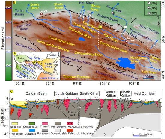
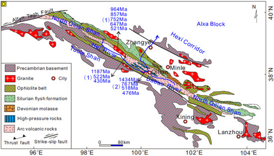
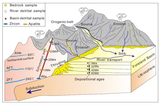
Understanding the formation of the North Qilian Shan in the NE Tibetan Plateau provides insights into the growth mechanisms of the northern region of the plateau across time. Detrital zircon fission-track (ZFT) analyses of river sediments can provide a comprehensive understanding of the
[...] Read more.
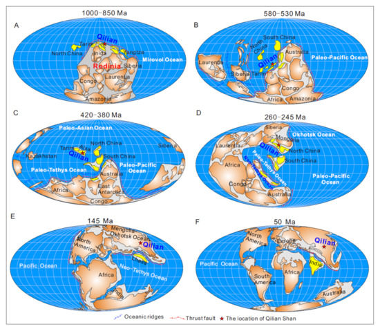
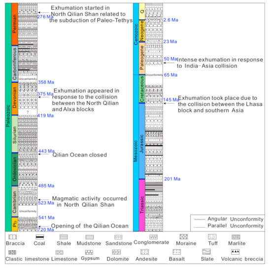
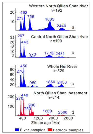
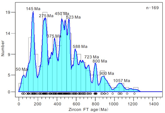
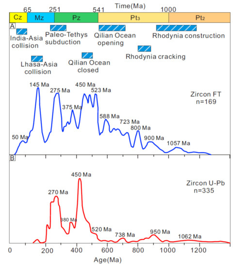
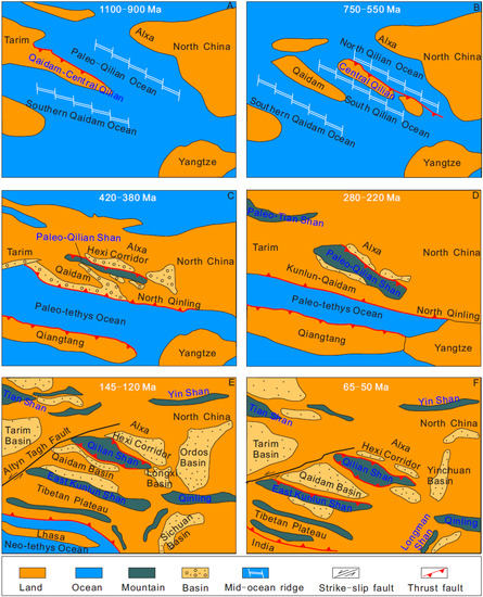
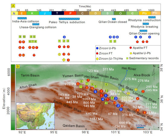
Understanding the formation of the North Qilian Shan in the NE Tibetan Plateau provides insights into the growth mechanisms of the northern region of the plateau across time. Detrital zircon fission-track (ZFT) analyses of river sediments can provide a comprehensive understanding of the exhumation history during prolonged orogenesis. Here, we applied the detrital thermochronology approach to the Qilian Shan orogenic belt. This work presents the first single-grain detrital ZFT data from river-bed sediments of the upper Hei River catchment in North Qilian Shan. The single ZFT ages are widely distributed between about 1200 Ma and about 40 Ma. These data record the protracted history of the Qilian Shan region from the Neoproterozoic evolution of Rodinia and late Paleozoic amalgamation of Central Asia to the accretion of the Gondwanian blocks during the Meso-Cenozoic era. Strong post-magmatic cooling events occurred in North Qilian Shan at 1200~1000 Ma, corresponding to the assembly of the Rodinia supercontinent. The age population at 800 Ma documents the oceanic spreading in the late Neoproterozoic dismantling of Rodinia. ZFT ages ranging from about 750 Ma to 550 Ma (with age peaks at 723 Ma and 588 Ma) are consistent with the timing of the opening and spreading of the Qilian Ocean. The age peaks at 523 Ma and 450 Ma mark the progressive closure of that ocean ending with the collision of the Qilian block with the Alxa block—North China craton in the Devonian. The Qilian Ocean finally closed in Late Devonian (age peak at 375 Ma). In the late Paleozoic (275 Ma), the subduction of the Paleotethys Ocean led to extensive magmatic activity in the North Qilian Shan. During the Lower Cretaceous (145 Ma), the accretion of the Lhasa block to the south (and potentially the closure of the Mongol-Okhotsk Ocean to the northeast) triggered a renewed tectonic activity in the Qilian Shan. Finally, a poorly defined early Eocene exhumation event (50 Ma) suggests that the NE Tibetan Plateau started to deform nearly synchronously with the onset of the India-Asia collision. This study demonstrates the usefulness of combining modern-river detrital thermo-/geochronological ages and bedrock geochronological ages to understand large-scale orogenic evolution processes.
Full article
►▼
Show Figures
Open AccessArticle
India Indenting Eurasia: A Brief Review and New Data from the Yongping Basin on the SE Tibetan Plateau
by
Tiannan Yang, Zhen Yan, Chuandong Xue, Di Xin and Mengmeng Dong
Cited by 12 | Viewed by 3317
Abstract
Successive indentations of Eurasia by India have led to the Tibet-Himalaya E–W orthogonal collision belt and the SE Tibetan Plateau N–S oblique collision belt along the frontal and eastern edges of the indenter, respectively. The belts exhibit distinctive lithospheric structures and tectonic evolutions.
[...] Read more.
Successive indentations of Eurasia by India have led to the Tibet-Himalaya E–W orthogonal collision belt and the SE Tibetan Plateau N–S oblique collision belt along the frontal and eastern edges of the indenter, respectively. The belts exhibit distinctive lithospheric structures and tectonic evolutions. A comprehensive compilation of available geological and geophysical data reveals two sudden tectonic transitions in the early Eocene and the earliest Miocene, respectively, of the tectonic evolution of the orthogonal belt. Synthesizing geological and geochronological data helps us to suggest a NEE–SWW trending, ~450 km-long, ~250 km-wide magmatic zone in SE Tibet, which separates the oblique collision belt (eastern and SE Tibet) into three segments of distinctive seismic structures including the mantle and crust anisotropies. The newly identified Yongping basin is located in the central part of the magmatic zone. Geochronological and thermochronological data demonstrate that (1) this basin and the magmatic zone started to form at ~48 Ma likely due to NNW–SSE lithosphere stretching according to the spatial coincidence of the concentrated mantle-sourced igneous rocks on the surface with the seismic anomalies at depth; and (2) its fills was shortened in the E–W direction since ~23 Ma. These two dates correspond to the onset of the first and second tectonic transitions of the orthogonal collision belt. As such, both the orthogonal and oblique belts share a single time framework of their tectonic evolution. By synthesizing geological and geophysical data of both collision belts, the indenting process can be divided into three stages separated by two tectonic transitions. Continent–continent collision as a piston took place exclusively during the second stage. During the other two stages, the India lithosphere underthrust beneath Eurasia.
Full article
►▼
Show Figures

