


Land 2024, 13(4), 563; https://0-doi-org.brum.beds.ac.uk/10.3390/land13040563 - 22 Apr 2024
Abstract
The 2023 SDGs report underscores the prolonged disruption of COVID-19 on community living spaces, infrastructure, education, and income equality, exacerbating social and spatial inequality. Against the backdrop of the dual impact of significant events and the emergence of digital technologies, a coherent research
[...] Read more.
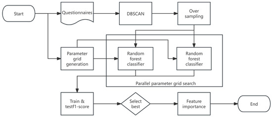
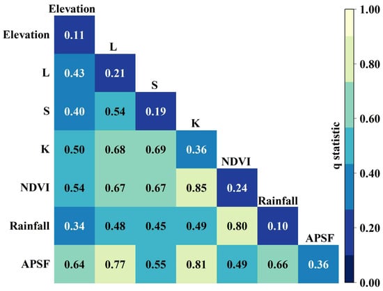
The 2023 SDGs report underscores the prolonged disruption of COVID-19 on community living spaces, infrastructure, education, and income equality, exacerbating social and spatial inequality. Against the backdrop of the dual impact of significant events and the emergence of digital technologies, a coherent research trajectory is essential for characterizing social–spatial equity and understanding its influential factors within the urban planning discipline. While prior research emphasized spatial dimensions and mitigated spatial differentiation to ensure urban equity, the complexity of these interconnections necessitates a more comprehensive approach. This study adopts a holistic perspective, focusing on the “social–spatial” dynamics, utilizing social perception (sentiment maps) and spatial differentiation (housing prices index) pre- and post-pandemic to elucidate the interconnected and interactive nature of uneven development at the urban scale. It employs a multi-dimensional methodological framework integrating morphology analysis of housing conditions, GIS analysis of urban amenities, sentiment semantic analysis of public opinion, and multiscale geographically weighted regression (MGWR) analysis of correlation influential factors. Using Suzhou, China, as a pilot study, this research demonstrates how these integrated methods complement each other, exploring how community conditions and resource distribution collectively bolster resilience, thereby maintaining social–spatial equity amidst pandemic disruptions. The findings reveal that uneven resource distribution exacerbates post-pandemic social stratification and spatial differentiation. The proximity of well-maintained ecological environments, such as parks or scenic landmarks, generally exhibits consistency and positive effects on “social–spatial” measurement. Simultaneously, various spatial elements influencing housing prices and social perception show geographic heterogeneity, particularly in areas farther from the central regions of Xiangcheng and Wujiang districts. This study uncovers a bilateral mechanism between social perception and spatial differentiation, aiming to delve into the interdependent relationship between social–spatial equity and built environmental factors. Furthermore, it aspires to provide meaningful references and recommendations for urban planning and regeneration policy formulation in the digital era to sustain social–spatial equity.
Full article
(This article belongs to the Special Issue Impacts of the COVID-19 Pandemic on Urban Planning, Design, and Management)


