

Photography Exhibition


 Integration of Remote-Sensing Techniques for the Preventive Conservation of Paleolithic Cave Art in the Karst of the Altamira Cave
Geomatic remote-sensing technologies such as 3D terrestrial laser scanning (3DTLS), drone flight, and ground-penetrating radar (GPR) allow us to generate exhaustive documentation of caves and their environment in 2D, 2.5D, and 3D. However, only its combined use with 3D geographic in-formation systems (GIS) lets us generate new cave maps with details such as overlying layer thickness, sinkholes, fractures, joints, and detachments that also more precisely reveal interior–exterior interconnections and gaseous exchange; i.e., the state of senescence of the karst that houses the cave. Information of this kind is of great value for the research, management, conservation, monitoring, and dissemination of cave art.


 New parameterization scheme for SSEBop using the Forcing and Normalizing Operation (FANO)
A graphical illustration of the new FANO parameterization of the SSEBop ET model. The FANO Equation is based on the theoretical formulation of Senay Approximation that determines the wet-bulb boundary condition using land surface temperature, Normalized Difference Vegetation Index (NDVI), and the inverse of surface psychrometric constant (dT). FANO eliminated the high NDVI requirement to parameterize the SSEBop model, thus, allowing ET estimation at all vegetated landscapes and seasons irrespective of vegetation cover density.


 Pigeons to monitor urban air quality
Despite being the main greenhouse gas, CO2 is still scarcely considered in public air quality monitoring networks. On top of that, sampling the urban air is quite a challenge: fixed sensor stations are usually on the ground level, not allowing for the investigation of the air column. UVA or atmospheric probes could make up for that, but their use is restricted and, in some places, just unfeasible. That’s where birds come to the rescue. Urban birds use the aerial habitat in all three dimensions. They move over trafficked roads, buildings, parks, fields… And as they do, they can collect data about the air they fly in. The small black object on the back of this pigeon is a CO2 sampler. Paired with GPS, relative humidity and temperature sensors, it has allowed the bird to give us information about the air in Rome, Italy, where he and other homing pigeons have been released repeatedly from January to June 2021. Thanks to them, we have evidence of the importance of green spaces in the city, where the pigeons have detected lower mean CO2 values with respect to urban fabric. Biologging, or the use of animal-borne sensors, has allowed researchers to collect data about animal movement, behaviour, physiology and environment. The idea of using free-ranging animals as monitors of the planet has fascinated the biologging world since its dawn. Technological limits and the complexity of dealing with opportunistic data are the main obstacles to this endeavour, but our paper shows we are in the right direction to have wild animals as sentinels of our shared environment.


 The Four Seasons
Borrowing the title of the four concertos composed by Italian composer Antonio Vivaldi “The Four Seasons”, this picture portrays the seasonal changes of canopy state in a species-rich, cool-temperate forest, from the leafless stage in April, budburst time in May, mature canopy in July, to the colorful canopy in November. The pictures were taken in 2019 using DJI Phantom 4 Pro from approximately 20 m above the forest canopy during the leaf phenology study in Shizuoka Prefecture, Japan.


 A Review of Remote Sensing for Water Quality Retrieval: Progress and Challenges
This is a frame diagram of our review of water quality retrieval. This article presents the application of remote sensing for water quality retrieval, and mainly discusses the research progress in terms of data sources and retrieval modes. Among them, the data sources include satellite-borne remote sensing data and non-Satellite remote sensing data. The retrieval modes include empirical mode, semi-empirical mode, analytical mode and AI mode. We summarize some retrieval algorithms for several specific water quality variables, including total suspended matter (TSM), chlorophyll-a (Chl–a), colored dissolved organic matter (CDOM), chemical oxygen demand (COD), total nitrogen (TN) and total phosphorus (TP). We also discuss the significant challenges to atmospheric correction, remotely sensed data resolution, and retrieval model applicability in the domains of spatial-temporal and water complexity. Finally, we propose possible solutions to these challenges. The review can provide detailed references for future development and research in water quality retrieval.
 Water Quality Chl-a Inversion Based on Spatio-Temporal Fusion and Convolutional Neural Network
High spatiotemporal resolution images are generated by image matching and spatiotemporal fusion, building an inversion model of chlorophyll-a based on convolutional neural network, and using pixel correction to correct the inversion results, we can obtain chlorophyll-a time series with high spatial and temporal resolution.


 Compressed SAR Interferometry in the Big Data Era
A novel open-source ComSAR InSAR algorithm based on a compression technique to provide millimeter-scale deformation measurements over time.

 Remote sensing monitoring of maize health phenotypes under saline-alkali soils in the Hexi Corridor of Northwest China
Agriculture is a major water user in arid and semi-arid areas, and irrigated agriculture is facing tremendous pressure to reduce water use with the intensification of water demand in other industries, such as industry and the ecological environment. Meanwhile, agricultural production is also facing serious soil salinization problems in heavily irrigated arid agricultural areas. Therefore, monitoring crop water status continuously and accurately is essential for understanding the response of crops to water and salt stress, optimizing irrigation systems, saving water, and suppressing salt. This article had proved that crop water stress index (CWSI), based on canopy temperature, has great application potential in diagnosing crop stress conditions, predicting physiology and growth health under water and salt stress.


 The indication of current changes of permafrost conditions in the Kolyma River, Northeastern Siberia
Giant aufeis are typical for the mountainous parts of the Kolyma River. They form within the interaction of permafrost, groundwater and river streamflow. Their dynamic well recognized at remote sensing images may serve as the indication of current changes of permafrost conditions.


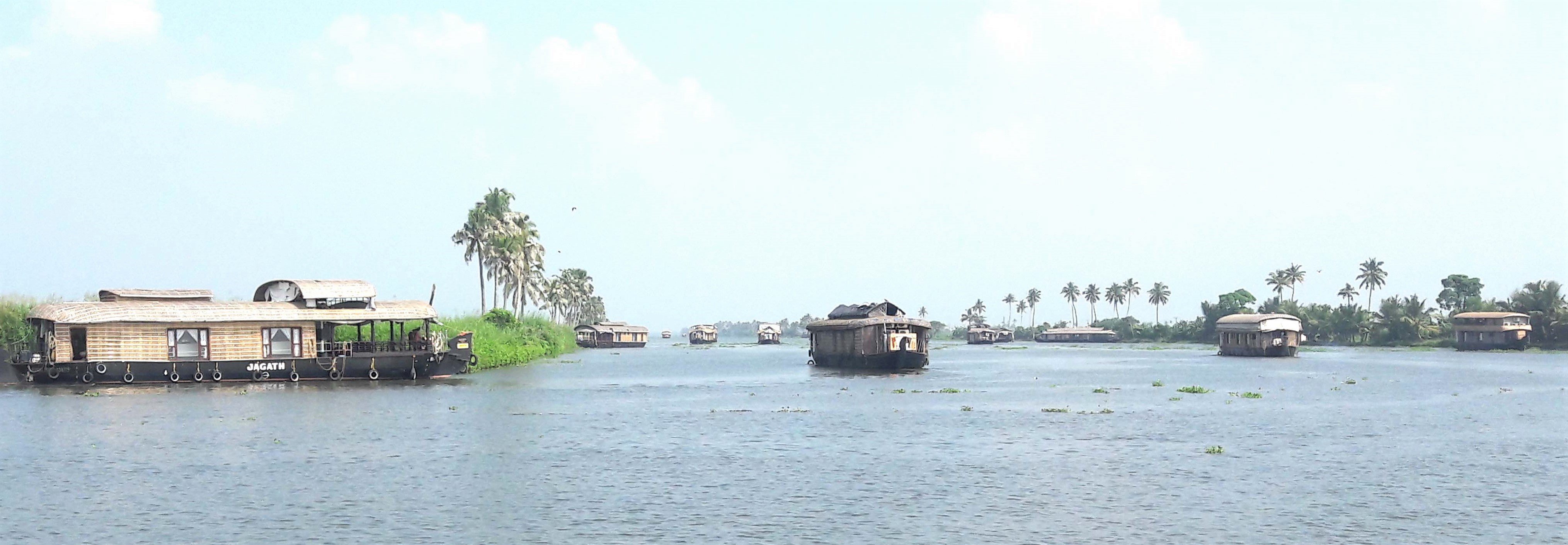 House Boat Tourism in Vibrio Infested Vembanad Lake
We recently reported the distribution of V. cholerae in Vembanad lake along the southwest coast of India, where cholera is endemic. Fluctuations in essential climate variables are found to influence the association of Vibrio cholerae with their environmental reservoirs, which in turn influence the suitability of natural water resources for human consumption. According to our study, bacterial pollution is rampant in the lake with the ubiquitous presence of Escherichia coli and other disease-causing pathogens from ill-equipped sewage treatment systems of the city or houseboat tourism. A large number of houseboats, beyond the carrying capacity of the lake, are operated in the southern part of the lake. The image taken from the Vembanad lake shows the heavy traffic of houseboats in the lake. The invasive aquatic weed, another menace in the lake and a preferred colonisation site for disease-causing vectors can also be seen in the photograph.


