Spatial Distribution of Local Forest Products at the End of the 19th Century: A Case Study of Former Villages in Iwate Prefecture

Faculty of Policy Studies, Iwate Prefectural University, 152-52 Sugo, Takizawa-shi, Iwate-ken 020-0693, Japan
Forests 2020, 11(10), 1044; https://0-doi-org.brum.beds.ac.uk/10.3390/f11101044
Submission received: 18 July 2020
/
Revised: 20 September 2020
/
Accepted: 25 September 2020
/
Published: 28 September 2020
(This article belongs to the Special Issue Assessing, Valuing and Mapping Ecosystem Services)
Abstract
:Recent research in Japan has investigated how local people historically utilized natural resources, using geographic information systems (GIS). These works have helped to clarify the role of forest provisioning services in the past, and have shown how modern landscapes were formed. The aim of this study was to elucidate the utilization of plant resources in forest landscapes of both fields and mountains, in the late 19th century in Iwate Prefecture, located in northeastern Japan. This study focused on a different area and a larger scale than previous studies, and included information from 642 villages. This study specifically focused on what kinds of forest products were historically used and shipped, which species were used, and how these uses were distributed around the prefecture. A combination of historical documents and GIS mapping, named MANDARA, was employed. The primary historical document was “The topography of Iwate Prefecture” that was published from 1876 to 1885, and recorded the products used in each village. A wide range of forest products were recorded, which contained both edible and inedible plants further split into 10 primary categories: edible wild plants, mushrooms, nuts and berries, medical herbs, timber, agricultural and construction materials, fuel, tree sap, bark, and others. Many villages also produced various secondary processed goods. Fifty-two species were specified as forest products, which included some estimation, and were composed of 19 herbaceous and 23 arboreal species. GIS mapping of each village indicated that firewood and charcoal were shipped to towns located in southern Iwate, from around Kesen County. People might trade these fuel woods on markets. On the other hand, chestnut (Castanea crenata S. et Z.) and acorn were produced in the low-density populated area all around Iwate.
1. Introduction
Forest ecosystem services are currently the focus of public attention, particularly for their potential provisioning, regulating, and cultural services. In mountainous areas, forest ecosystem services are especially important as forests provide wood and non-wood products that inhabitants rely on for their livelihoods. Forest products provide inhabitants with not only the opportunity to earn an income (e.g., commercial forestry), but also help them to maintain their self-sufficient lifestyle. Local residents can also enjoy the blessings of nature, such as edible wild plants in early spring, wild fresh mushrooms in autumn, or the warmth of a wood fire in winter. Consumer goods are not always a suitable substitute for these local resources. Additionally, people living in mountainous areas in many countries depend on not only forestry, but the unique techniques and skills to use local resources that forests have. Kito [1] called these technique and skills “minor subsistence,” which play an important role to enrich the people’s awareness of nature.
In Japan, some economists [2,3], writers [4], and entrepreneurs who have started local ventures in remote areas in the nation [5] are struggling to find methods to revitalize local communities, where populations are declining and local industries are weakened by the modern global economy. Many Japanese villages have suffered long-lasting economic stalemates due to problems such as population decline, long-term price declines for farm and timber products, and the decline of local public works-related expenditures. Although consumers desire local products both domestically and internationally, there is still a lack of information regarding the historical use of local resources, such as indigenous farm crops with historical backgrounds.
A new method is available, which combines historical records with geographic information systems (GIS). This modern method creates a user-friendly interface that can visualize how local people have utilized forests in the past, which can help us to better understand how modern forests and landscapes formed over time, especially in areas intensively used by humans. For example, Horiuch et al. [6] used local farmer diaries, interviews, and GIS mapping to clarify “how local people in the late Meiji Period used forest resources in satoyama landscape.” The late Meiji Period was around 1900–1910. In another example, Hayashi et al. investigated the use of natural resources around Lake Biwa, the largest lake in Japan, during the late 19th century [7]. Using Arc GIS, Hayashi et al. manufactured maps that depicted timber production, as well as firewood, charcoal, and other non-timber forest product use around the lake coast at that time. Oka gave a detailed explanation of the distribution and utilization of mammals by local villagers in the latter half of the 19th century in Iwate Prefecture, based on “Iwate-ken Kankatsu Chishi” [8]. He pictured the presence of wild boars, Japanese deer, and Japanese monkeys in Iwate on the map, and clarified that one of the most useful mammals was the Japanese deer. Their skin was utilized as clothes and bags, their horns as whistles, dices, and lures, and their meat as food. Japanese deer were mainly produced from Kesen County in the past.
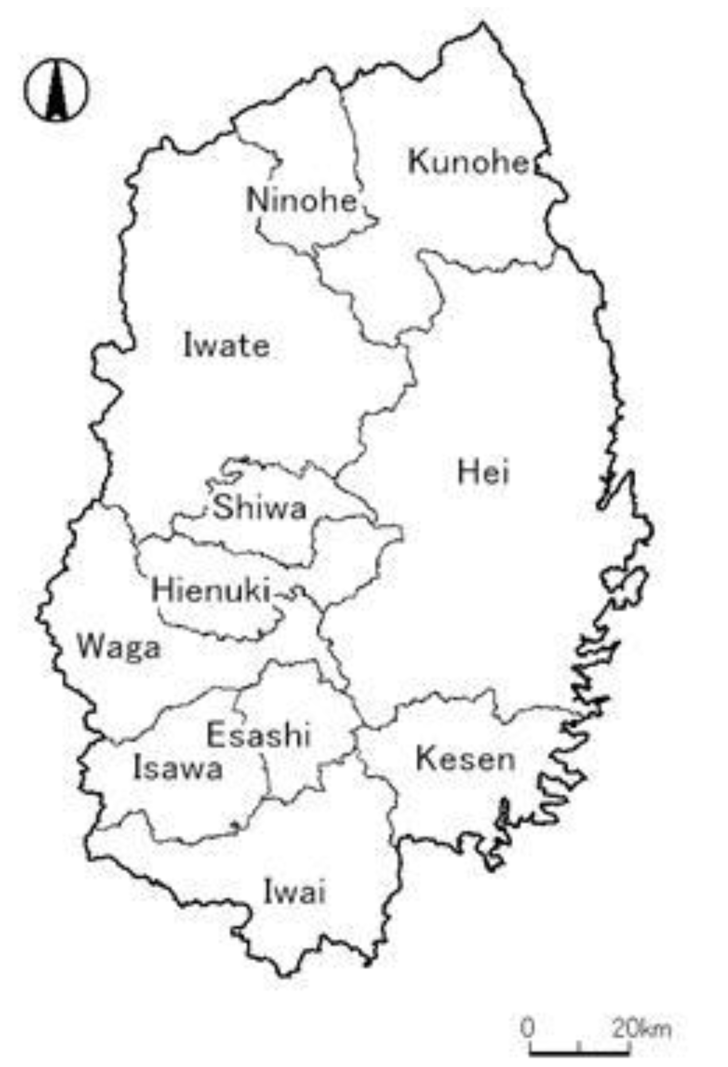
This paper describes the historical production of different forestry products (e.g., edible plants and wooden goods) at the county and village levels in Iwate Prefecture in northeastern Japan, with references to studies authored by Hayashi et al. [7] and Oka [8]. The northeast of Japan is in the zone of deciduous broad-leaved trees. During the Tokugawa period (1600–1867), feudal domains exported considerable amounts of high-quality natural timber and horses—requiring a huge mountain field to grow up—to the Tokugawa government in Edo. In modern times, timber, charcoal, and military horses, which require a large field to grow up, were shipped from northern Japan to Tokyo and other cities. The aim of this research was to explore how forest products were used in Iwate Prefecture (Figure 1) during the 1870s and 1880s.
2. Methods
2.1. Study Area—Iwate Prefecture
The subject of this study is Iwate Prefecture, located in northeastern Japan on the Pacific coast (Figure 1). It is the second largest prefecture in Japan, with an area of about 1,528,000 hectares. Forested areas in Iwate cover about 1,171,000 hectares, which is 77% of the whole prefectural land. Agricultural land occupies 150,000 hectares, two-thirds of which is used for paddy fields. The coast of the prefecture is called “Sanriku” and was tremendously damaged by the Great East Japan Earthquake Tsunami. The majority of the prefecture is mountainous with altitudes varying from sea level to the highest peak, Mt. Iwate-san, reaching about 2000 m. The Ohu mountain range stretches to the west until the Akita prefecture. The Kitakami mountain range lies parallel to the Ohu mountains. The Kitakami river flows between these two mountain ranges, and is a large watercourse that runs through the middle of the prefecture from north to south. The central part of Iwate Prefecture is similar to that of the Kitakami river watershed.
Annual average temperatures in the prefectural capital, Morioka, was 10.2 °C from 1981 to 2010. Annual total precipitation was 1266.0 mm during the same period [9]. Heavy snowfall is often observed in the Ohu mountains.
The prefecture in modern times has a low population density, which can be as sparse as 81.2 people per square kilometer, and had a total population of approximately 1,240,000 in 2018 [10].
Iwate Prefecture was ranked third in Japan for its total log production in 2017, and was ranked second in Japan’s production of hardwood logs [11]. In addition, Iwate ranked the top in Japan for the production of red pine (Pinus densiflora Sieb. et Zucc.) from 2010 to 2015 [12]. The Iwate red pine is particularly prized for its excellent quality, which is a requirement for the long beams found in traditional Japanese wooden constructions—castles, temples, or shrines. Iwate has also positioned itself as the sixth leading producer of fresh shiitake mushrooms (Letinus edodes Berk.), the third leading producer of dried shiitake mushrooms, and the leader in charcoal production in 2017 [11]. Japanese lacquer produced in Iwate also has great significance for the repair of cultural assets, due to its rare quality. As indicated from this information, Iwate continues to be active in the production of both timber and non-timber forest products.
2.2. Historical Background of the Study Area—Forest and Field Utilization
The boundaries of Iwate Prefecture were established in 1876 during the Meiji Restoration, when the Nanbu feudal domain in the northern area of modern Iwate and the Date feudal domain to the south were combined. At the end of the Tokugawa period (1600–1867), major products from this region, particularly from the Nanbu domain, included, for example, iron, salt, and horses. The various industries found in the region at that time required the interdependent use of the forests and fields in the Kitakami mountains. People used fields for meadows, grazing, swidden agriculture, etc. As can be seen in the following examples, people in Iwate used and relied on both forests and grasslands, which often had interchangeable borders. The following information is taken from Oka’s work [13] unless otherwise noted, and provides several examples of this interdependency.
Traditional Japanese “tatara” steel making methods required good iron mines to be located near large wooded areas, which supplied the logs needed for charcoal production [14]. “Tatara” steel involves the production of iron from iron sands by pumping a bellows. This manufacturing process continued until the Meiji era (1986–1912), when the modern iron industry was introduced in Iwate.
In the Sanriku coastal regions, where sandy beaches rarely form due to its ria shoreline, coastal villagers relied on forests to help manufacture and export salt. Firewood was needed to boil the salt from seawater, and the seawater was boiled in the high-quality iron pots made in Iwate. The salt industry was widespread up until 1909, when the national government began to monopolize salt production for the sake of financing the Rosso–Japanese War during 1904–1905.
Transportation relied on draft animals to transport these products and materials, which resulted in people keeping cows [14]. Cow excrement was also used as an agricultural fertilizer. A study from 1939 states that 2 to 3 tons of fresh grass was needed per year to raise a cow, which villagers gathered in the meadows near the mountains, where they also pastured their cows in the summer. Cows have played an important role in the formation of the landscape, especially in the Kitakami mountains which consist of secondary broad-leaved forests and grasslands. There is also Oka’s fine report about cows and landscape in Iwate [13]. This study focuses on horses rather than cows.
Acorns and conkers from forest regions were also important as an alternative food source that saved people from starvation during times of famine or years with poor harvests. Villagers had to remove the tannins and saponins found in these nuts prior to eating, due to their toxicity. This was accomplished via drying, peeling, water immersion, and boiling, which are all processes that required lots of firewood and fresh water.
2.3. Materials and Methods
The principal reference used was the Iwate-ken Kankatsu Chishi, which translates to “The topography of Iwate Prefecture,” referred henceforth as the topography [17] (Figure 2). This was edited in the 1870s and 1880s. This original work is composed of 11 volumes, with 130 books. Different writers edited the information from each county, which resulted in partially disparate descriptions for each volume. Iwate Prefecture began publishing the topography in 1876, after the Japanese national government ordered each prefecture to oversee the publication of their topography in order to publish a centralized national topography [18]. The topography was published until 1885. The original edition of the topography is so rare that a reprinted edition was published in 2003, to which we refer in this paper.
Information recorded in the topography included, for example, county and village boundaries, mountains, rivers, population size, and land use for each of the 642 villages in the prefecture, as well as what products each village used or produced. The produce items were of particular interest because they show what various local products were found in each village. Items in the topography were recorded, but not quantified; therefore, we were only able to establish an item’s presence in each county and village. Each county’s location is displayed in Figure 3.
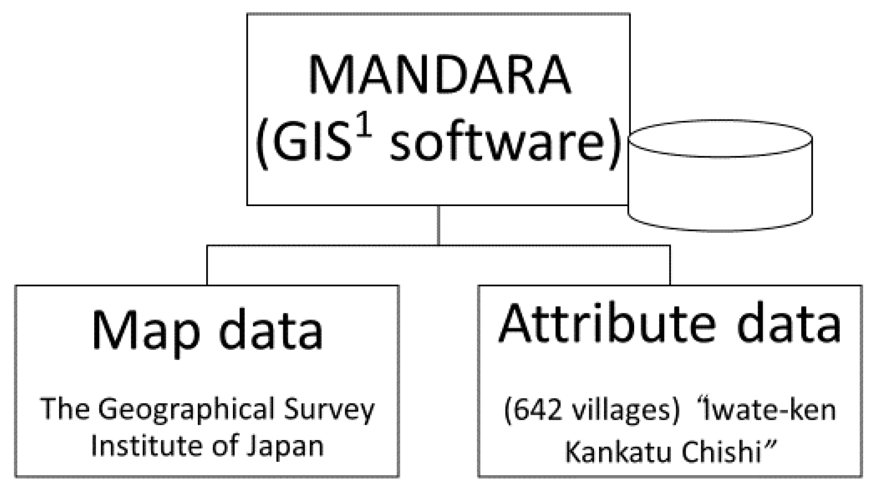
To obtain the GIS mapping data, we first entered our collected attribute data into a spreadsheet program. These data included paddy field area, cultivated land area, population size, livestock population size, and the local products from 642 villages. Spatial data were prepared with MANDARA software, which was developed as a free GIS program by a Japanese geographer [19]. Historical village borders were determined using small area data from the 2000 national census in Statistics Map of Japan [20], which was a spatial boundary available in a shapefile.
Hereafter, this boundary is referred to as “parcel.” Parcel boundary data are polygons, much smaller than municipalities, which are formed of blocks or streets in an urban area, and are community-based smaller divisions in a rural area (called “aza” in Japanese). The number of parcels is 3752. This is the finest polygon data, which is directly compatible with GIS. Each parcel area was 4.1 square kilometers on average. The maximum was 233.1 square kilometers and the minimum was 0.001 square kilometers. Parcel data manufactured in 1999 are both the oldest and only available data. Though these boundaries are based on modern administrative and population conditions, it is suited to determine each historical village boundary. This information was validated by being superimposed on a map of Iwate Prefecture at a scale of 1 to 25,000 by the Geospatial Information Authority of Japan [21].
These parcels were merged based on the description in the topography. In the topography, village boundaries were described. An example description is “the west side of X village abuts to Y village with Z stream.” Such statements, when taken together with the parcel boundaries, formed the basis of the historical village boundaries for this study. If a village boundary could not be determined, which was rare in this survey, the boundary was estimated using mountains, streams, rivers, or modern roads. The historical village can be expressed as a polygon. The total area of each historical village was calculated using GIS. Historical villages’ areas were 23.8 square kilometers on average with the maximum being 304.2 square kilometers and the minimum being 0.1 square kilometers. Relatively larger historical villages were mostly located in the mountainous area, where the forests and fields occupied the majority of the village. Every piece of attribute data would be connected to a historical village on the map through standard GIS procedures.
A large variety of forest products was documented in the topography. Since villagers used mountains and fields seamlessly, we counted mountainous plants and grassland plants as one unit. In modern times, some plant species that can be found in natural environments can also be cultured by people. In such instances, we assumed that people in the 1870s and 1880s depended primarily on resources gathered from natural environments. For example, lily bulbs are generally planted and cultured on farmland today, but during our research time period, we assumed that lily bulbs were more likely gathered from mountain areas. If it was unclear how a forest product mentioned in the topography was used, we gathered more information from the “Encyclopedia Iwate” [22] and “Verbatim Record of Local Foods” [23] or inquired at Iwate Prefectural Museum. Wildlife, which contained two bird species and 10 mammal species, were not counted.
During the categorization process, some conjecture needed to occur. For instance, if just the word “chestnut” (Castanea crenata) was listed in the topography, we counted the listing as the nut, not the timber, because records of chestnuts as a nut appeared more often than a timber. In other instances, some similar products were merged, such as some specialty charcoals used for smith crafts, which were counted in the larger charcoal category. For timber, “board of X,” “log of X,” etc. were merged to become “timber of X.”
For the assessment of the methodology, a strength of this method is being able to visualize a huge amount of complex data in single map. We can treat more fine spatial data than that based on modern municipalities’ boundaries, whose total is 33 in Iwate, today. In addition, since different types of maps can be easily laid on each other, the mutual relationships between various attribute data would be understood intuitively. In contrast, a weakness is that this method and data do not treat the data chronologically because there is only one period of data. In addition, the minuteness or roughness in the description of topography are not evaluable. Therefore, it was not clear how the editors researched each historical villages’ products.
3. Results
3.1. Recorded Forest Products—Categories and Species
In Table 1, the major forestry products listed in the topography are shown. In summary, chestnuts were listed in 153 villages, firewood was listed in 92 villages, charcoal was listed in 78 villages, and acorns were listed in 68 villages. The total number of villages was 642. The importance of acorns as a food source in mountainous areas in the winter is indicated here by the number of villages that listed acorns as a product.
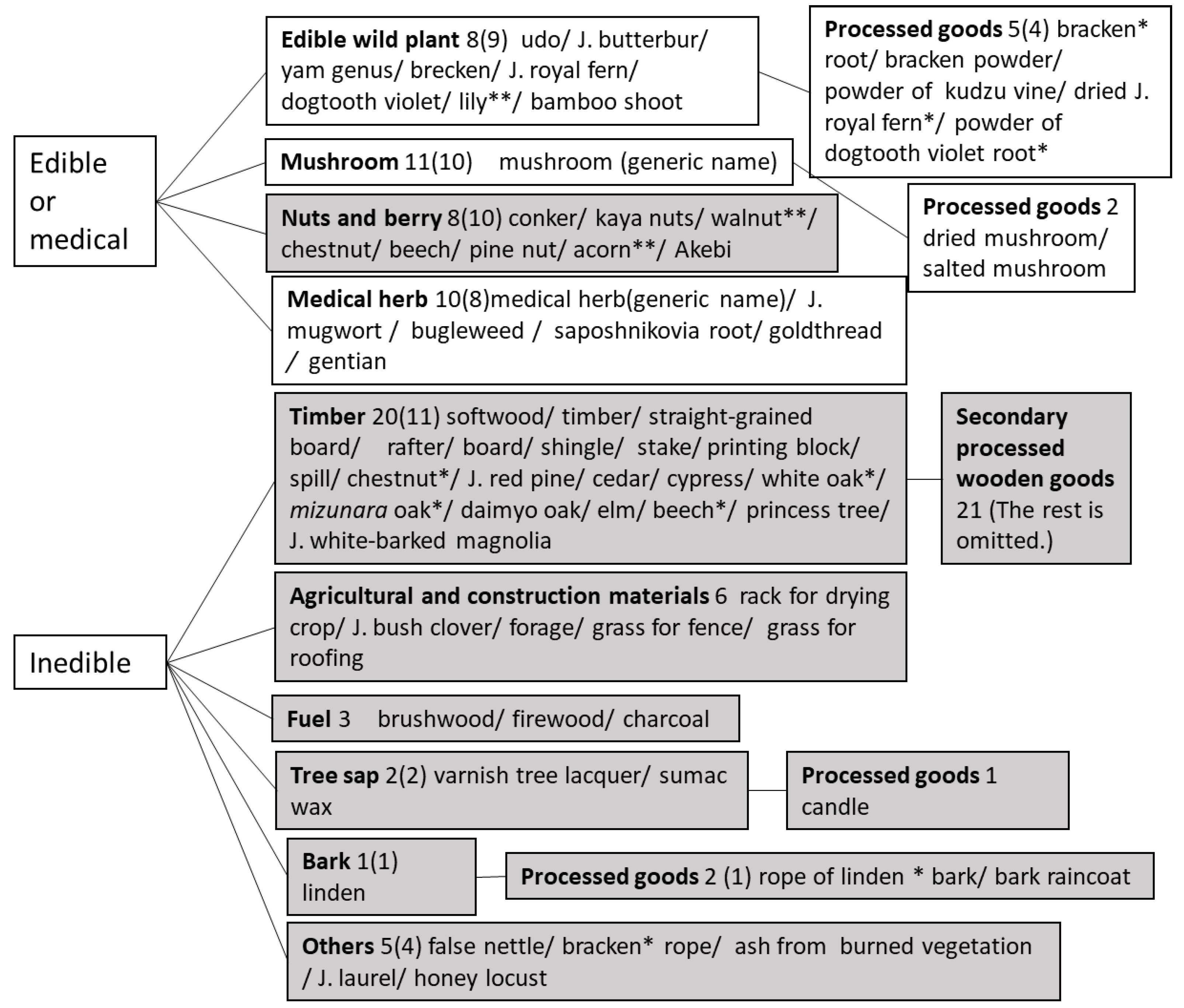
Forest products recorded in the topography (Figure 4, and Table 2) were classified into two categories: edible or medical plants, and inedible plants. Edible plants comprised mostly herbs and fungi, while inedible plants mainly included wood plants. From these two main categories, each plant product was further classified into smaller categories.
Fifty-two unique plant species were found in the topography, which includes some estimation. For example, the usage of Japanese laurel (Aucuba japonica var. japonica) was not clear in the literature; therefore, it was assumed that people gather that for garden trees. The edible category consisted of 10 species of wild edible plants (including the processed goods), 10 species of mushrooms, nine species of nuts, one species of berry, and eight species of medical herbs (only identified species were counted). The inedible category consisted of 11 species of timber, two species of tree sap, one type of bark, and five items counted as “other” (fiber, ash, garden tree, and cleaner). The other category included four species. Some items were counted twice because some plant species were applicable to multiple categories. For example, young bracken shoots were widely used as an edible wild plant, while older bracken plants were used as a fiber. Although inedible products also could have included many agricultural goods, construction materials, fuels, and secondary processed wooden goods, the plants listed were hardly identified for these usages.
We identified the species for each product listed in the topography. Acorn and timber were classified as coming from either white oak (Quercus serrate Thunb.) or mizunara oak (Quercus crispula Blume), because these two species are very common, are considered the most useful broad-leaved trees found in Iwate, and sometimes coexist in forests. In the Kitakami mountains, mizunara oak was preferred, since its acorns are bigger than those of white oak and were easier to gather [24]. “Cypress“ was considered to indicate Thujopsis dolabrata var. hondae in Iwate. In modern Iwate, Thujopsis dolabrata var. hondae is called “cypress,” since real cypress does not grow in Iwate.
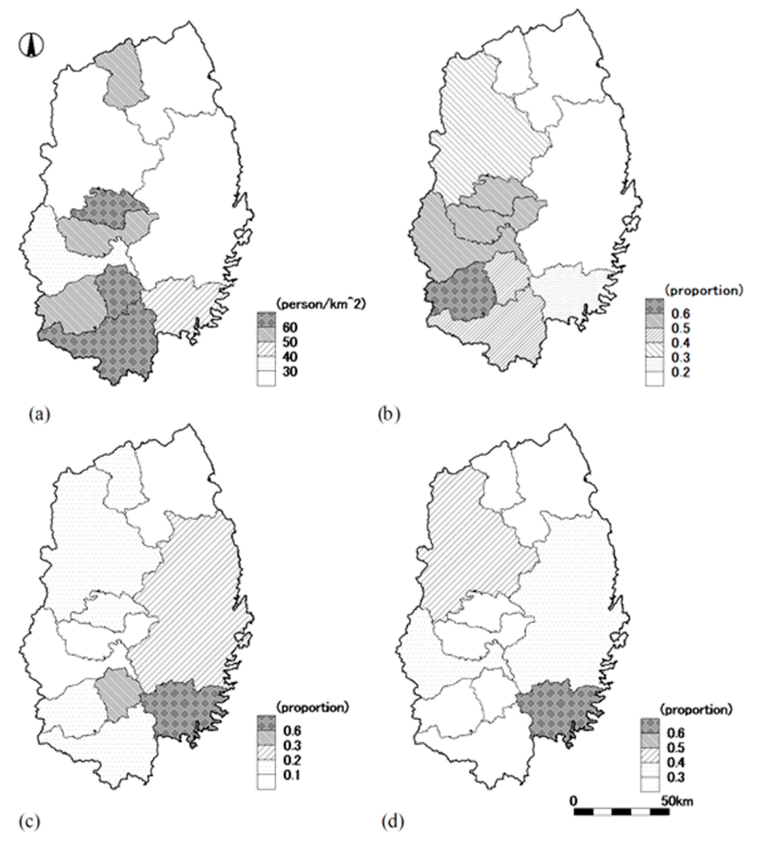
3.2. Major Forest Products and Forest Products Analysis by County
Attribute data were examined for each county and are visualized in Table 3 and Figure 5, which led us to form three conclusions. First, counties with high population density also tended to have a high density of horses. The ratio of total farmland to total area and the ratio of paddy fields to total farmland in these counties were also apt to be relatively high. To save space, horse density distribution and total farmland ratios are omitted from Figure 5. The large amount of horses in these regions may have been due to the need for horses to plow paddy fields prior to planting young rice seedlings. Horses were also needed to transport and scatter fertilizer for the rice to grow. Horses were so critical for the cultivation of rice 150 years ago that poor peasants borrowed their horses from major landowners. The peasants, in return, had to help the landowner when the landowners requested them [27]. Horses were also used to help remove logs from the forest.
Second, the proportion of villages producing firewood to the total number of villages was similar to that of villages that produced charcoal. The charcoal map was excluded to save space. These two products, which were made from the same kind of tree (typically oak), were produced primarily in Kesen and Esashi Counties, both of which are in the southern part of Iwate. In Kesen County, 70% of the total villages produced firewood. In Esashi County, 33% of the total villages produced firewood. In Hei County, 21% of the total villages produced firewood.
Third, the maps displaying chestnut and acorn revealed different trends. While chestnut was produced in inland counties and Kesen County, acorn tended to be produced in northern Iwate, particularly in the Kitakami mountains. The reason for this may be that villagers in the Kitakami mountains preferred acorns over chestnuts as a stock food for times of famine, since chestnuts are too sweet to eat as a diet staple [24]. Toward the end of the Tokugawa period, around the 1850s, the local government recommended villagers to grow their chestnut trees in natural forests in order to prepare them for times of famine. All the way up until the 1930s, it was popular for villagers across Japan to cultivate natural chestnut trees to harvest chestnuts [28].
3.3. Major Forest Products Analysis by Village—Layered with Other Specifications
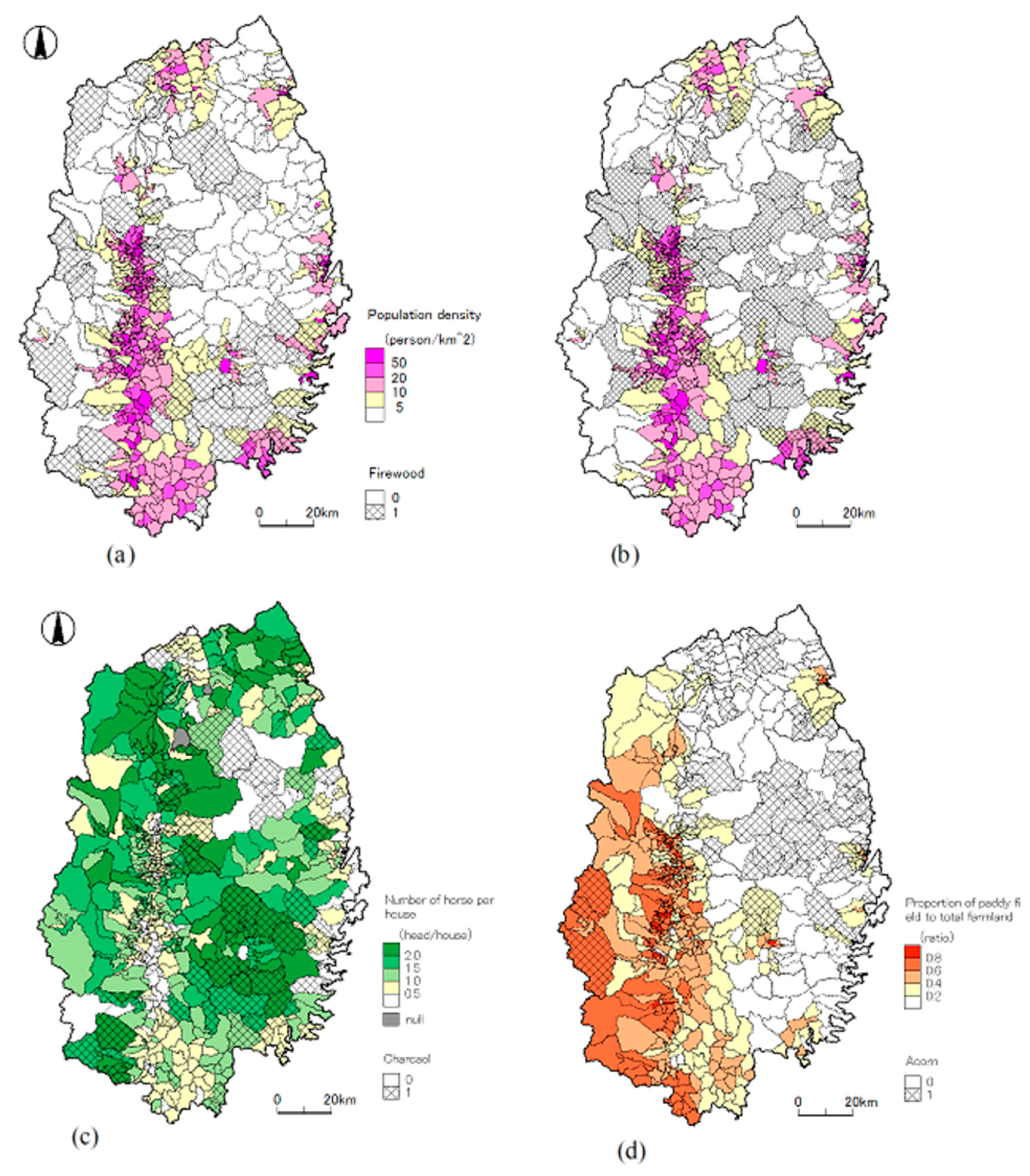
Figure 6 shows some forest products related to population density; for example, the number of horses per household, not including temples and shrines. During our study period, the average population density in Iwate Prefecture was 37.69 people per square kilometer. In particular, villages with low population densities seemed to be correlated to some of these products. Our results show that mountainous villages, which had fewer paddy fields than villages in non-mountainous areas, were more dependent on timber, wooden fuel, nuts, and other forest products for their livelihood.
Firewood and charcoal seemed to be primarily produced in southern Iwate, which was presumed to be an area with a high-density population on the Kitakami riverfront. This might imply that these riverside areas bought the firewood and charcoal for their daily use at their markets. This firewood and charcoal would have been transported to the riverside towns from the mountains. In northern Iwate, however, wood fuel production was not clearly observed, and charcoal production in northern Iwate did not involve the market economy until the railway moved beyond Morioka and the more northern parts of Iwate at the end of the 19th century.
Chestnuts and acorns were recorded more often in areas of low population density, not reported around high-population towns, and compared with fuel woods in the north region. In the same way as population density, a low proportion of paddy fields was also connected with production of these nuts. Chestnuts and acorns were able to help compensate for crop shortages, and were likely consumed in autarky or barter, and not traded on markets. Conkers were not popular in the Kitakami mountains because it was difficult to remove their hard outer casing. They also needed no less than 10 days to remove their harshness after 10 days of soaking [24].
The number of horses per household was comparatively large in Kesen County and northwestern Iwate County. In Kesen, firewood and charcoal production were high, and horses were used to contribute to pull logs and transport goods. Timber from pine and cedar (Cryptomeria japonica) trees were recorded at the foot of the mountains. In some villages, (e.g., villages in Iwate and Kesen Counties), two kinds of coniferous timber were recorded together, while in other areas, such as in the northern part of Hei County, only one type of timber (in this case, pine) was recorded. One explanation for this could be that during the study period, the timber industry might have been small, as shipping products would have required more natural resources.
4. Discussion
A better understanding of the past helps us to rediscover the significance of modern natural resources, which are environmentally sustainable, support daily life, and may be beneficial to human health. The reason why is that the resources would exist nearby. If we use local resources, energy consumption would become lower. Local resources would be less affected by the world situation; moreover, if we use local resources, our income would be apt to stay in our region, as a price paid by us to the supplier for goods. Local edible resources are fresher and more traceable than global goods. Ito said that if mountainous communities relied on a single industry, (i.e., commercial forestry based on Japanese cedar plantations), the local economy would be more vulnerable to variations in the global economy [29]. The use of a variety of resources, which were composed of 11 tree species in the timber category alone, might have been advantageous to the Iwate region.
Recent unique log production in Iwate was a result of the people’s utilization of forests and fields in the past. Today, Iwate produces high-quality red pine for large-size logs and various kinds of hardwood for furniture, craft, charcoal, and mushroom bed logs, as mentioned above. Red pine forests or broad-leaved secondary forests grew where people used forests and fields intensively, such as tree cutting, gathering fallen leaves, burning the field, or grazing cattle [15,16,30,31]. Today, if we rarely involved such tasks, forest physiognomy would likely be more simplified. In the view of the relationship between people and forests, it should be more highlighted to practice mushroom production on logs, charcoal making, and graze with native pasture [32]. These involvements play an important role in maintaining red pine forests or secondary forests.
A few foreign research articles are reviewed for discussion. Szabo et al. [33] have produced the LONGWOOD geodatabase, which includes all available land use and forestry data from the 11th century to the 20th century. Their subject area is Moravia, which expands 27,000 square kilometers in the Czech Republic. They defined the area the unit “township” and gave the chorological forestry information for every township whose number was as much as 3567 polygons. They input elevation, forest physiognomy, species, and forest management. The characteristic of this database is to hold long-time and huge amounts of forestry data, and include various attribute data related to other subsistence, e.g., litter raking, hay cutting, and woodland pasture. Szabo et al. showed that the LONGWOOD would make it possible to develop a wide variety of studies on forest management or land use, and so on. Since the study site of Szabo et al. in Moravia is similar in both spatial scale and climatic condition to Iwate Prefecture—the same species are observed in both studies. Our study is much rougher and could only acquire one period data from the past. Szabo et al. said “There is a trade-off between spatial precision and data quantity.” Here, the boundary of each historical village was defined carefully, but forest products were input by dichotomy—presence or absence.
Thompson et al. [34] elucidated the relationship between forest vegetation in the 17th century and today’s forest in the case of the northeastern United States, which expands 43 million hectares. They gathered pre-colonial forest information and combined these data with a modern forest inventory census. They set the research topics to be: forest compositional change, geography of change, and relationship between change and its cause. The chestnut is in seen both the pre-colonial period and today. Different compositions of forest tree species are seen in different costumes of past clearcutting for agricultural land use. They also say that late-successional species decrease; on the other hand, early- and mid-successional species are observed more frequently today. The study area is a relatively large regional scale and combined two periods of data together with numerical treatment. Our study analyzed a much smaller area and did not combine modern forest information. The number of villages in the Topography is over 600 making statistical tests possible. In the view of succession of forest species, the trend in Japan would be opposite of the northeastern US. Here, more late-successional species in the forest are found in general and early- and mid-successional species would be relatively fewer nationwide.
5. Conclusions
Here, we documented that a wide variety of forest plant products were used throughout Iwate Prefecture in the late 19th century. These products were categorized as edible or inedible plants. We identified 52 species of forest plant products from the topography. Typical examples of forest products at the time included fuel wood, nuts, and timber, which were harvested mainly in the mountainous and coastal areas in Iwate. We used this information to create layered maps, which displayed population density, paddy field ratio, and horse number per household, which tended to be correlated with forest product supplies. The more severe the conditions for survival were, the more people are apt to make use of forest goods [13].
Our method of using a combination of historical documents, combined with digital GIS, is stimulating, as it enables us to better understand large amounts of complicated information quickly. The combined information also helps us to better comprehend the local environment and landscape spatially in the past when photograph or precise large-scale maps had not yet become common.
This paper discusses the local supply of forest provisioning services 150 years ago. Szabo et al. said “The richness and diversity of forest-related archival data were rarely utilized to anywhere near their full potential” [33]. This study tried to use the potential of the topography in the view of forest product and landscape. Information contained within the topography continues to require further academic research, as many forest products have yet to be analyzed. Other products, such as farmland crops, marine food, or freshwater fisheries, are not mentioned at all. It would also be beneficial to compare past resource use with modern resource use, to better quantify the change in usage over time.
Funding
This work was supported by JSPS KAKENHI Grant Number JP 19K06345.
Acknowledgments
The Iwate Prefectural Museum had given appropriate advices for identifying many plants. Shimada, N. gave special implication for this study.
Conflicts of Interest
The authors declare no conflict of interest. The funders had no role in the design of the study; in the collection, analyses, or interpretation of data; in the writing of the manuscript, or in the decision to publish the results.
References
- Kito, S. Shizenhogo Shiso wo Toinaosu–Kankyo-rinri to Nettowaku—[The Reconsideration of Nature Preservation; Environmental Ethics and Networking]; Chikuma Shobo: Tokyo, Japan, 1996; pp. 148–149. (In Japanese) [Google Scholar]
- Samuta, H.; Yokemoto, M. Kimi no Machi ni Mirai ha Aruka–"Nekko" kara Chiki wo Tsukuru—[Dose your Town have its Future? How to Create the Community from its Root]; Iwanami Shoten: Tokyo, Japan, 2020; p. 200. (In Japanese) [Google Scholar]
- Fijiyama, K. Den’en-kaiki 1% Senryaku—Jimoto ni Hito to Shigoto wo Torimodosu—[The One percent Strategy for the Return of the Population and Employment to Rural Community]; Nosangyoson Bunka Kyokai: Tokyo, Japan, 2015; p. 228. (In Japanese) [Google Scholar]
- Shiomi, N. Han-no Han-X toiu Ikikata-–Kettei-ban--[The Lifestyle of Half-Agriculture and Half-X.; Definitive ed.]; Chikuma Shobo: Tokyo, Japan, 2014; p. 282. (In Japanese) [Google Scholar]
- Shinohara, T. Kamiyama Projekuto–Mirai no Hatarakikata wo Jikkenn Suru--[Kamiyama Project; Experimentation on How to Work in the Future]; Nikkei BP Sha: Tokyo, Japan, 2014; p. 224. (In Japanese) [Google Scholar]
- Horiuchi, M.; Fukamachi, K.; Oku, K.; Morimoto, Y. Patterns in the use of forest resources in satoyama landscape in the western part of Shiga Prefecture based on two diaries of the late Meiji Period. Landsc. Res. J. 2006, 69, 705–710, (In Japanese and English Abstract). [Google Scholar] [CrossRef] [Green Version]
- Hayashi, T. Shigaken Bussanshi no Shikakuka. [The visualization of “the topography about Shiga prefecture products”]. In Me de Miru Biwako Suiikiken—Hito to Shizen to Nariwai to--[Comprehensible Maps of the Watershed of Lake Biwa; Human, Nature, and livelihood]; The Research Center for Satoyama Studies, Ed.; Ryukoku University: Kyoto, Japan, 2019; pp. 111–118. (In Japanese) [Google Scholar]
- Oka, K. Kindai sanson ni okeru tayo na shigen riyo to sono henka—Kitakami sanchi no yasei dobutsu no gensho to Sanson no kurashi—[the Various utilization of natural resources and those changes in mountainous villages; the interaction between decrease of wildlife in the Kitakami mountain and livelihood of local villagers]. In Yama to Mori No Kankyoshi—Series Nihon-Retto No Sanman-gosen-nen: Hito to Shizen No Kankyoshi. [The Environmental History of Forests and Mountains; Series of 35 thousand Years in Japanese Archipelago; Environmental History of Human and Nature.]; Yumoto, T., Ikeya, K., Shirouzu, S., Eds.; Bun’ichi Sogo Shuppan: Tokyo, Japan, 2011; Volume 5, pp. 163–180. (In Japanese) [Google Scholar]
- Japan Meteorological Agency. Search for Meteorological Data in the Past. Available online: https://www.data.jma.go.jp/obd/stats/etrn/view/nml_sfc_ym.php?prec_no=33&block_no=47584 (accessed on 27 June 2020). (In Japanese)
- Iwate Prefecture. Statistical Information of Iwate. Available online: http://www3.pref.iwate.jp/webdb/view/outside/s14Tokei/bnyaBtKekka.html?c=B0203&r=I002&searchJoken=B02%3AB0203%3AI002 (accessed on 27 June 2020). (In Japanese).
- Iwate Prefecture. Index of Forestry in Iwate Prefecture in 2018. Available online: https://www.pref.iwate.jp/_res/projects/default_project/_page_/001/028/663/zentai.pdf (accessed on 27 June 2020). (In Japanese).
- Amano, T. Akamatsu-zai no riyo to ryutsu [the Utilization and distribution of Japanese red pine logs]. In Shinrinhogo to Ringyo no Bijinesuka--Mastugare ga Chiiki wo Tsunagu—[The Conservation of Forest and Business Opportunities of Forestry;Pine Bark Borer May Combine Local Stakeholders]; Nakamura, K., Otsuka, I., Eds.; Nihon Ringyo Chosa Kai: Tokyo, Japan, 2017; pp. 191–198. (In Japanese) [Google Scholar]
- Oka, K. Sanson ni okeru shinrin-shigen no riyo-shi--Mori ha hito ni tetsu ya shio ushi to yutakana shokuryo wo atae kikin ya kyoko, keppai kara sukutta—[the History of forests and those products utilization of in mountainous villages; the forests gave people iron, salt, cows, and unlimited foods in addition, they also saved people from famines, crisis, and nonpayment of wages]. In Ecological History of the Kitakami Mountains’ Landscape; Osumi, K., Sugita, H., Ikeda, S., Eds.; Kokon Shoin: Tokyo, Japan, 2005; pp. 121–137. (In Japanese) [Google Scholar]
- Mori, K. Nihon Hekichi No Shiteki Kenkyu Ge-Kan [Historical Analysis of a Remote Rural Area in Japan; Hosei University Press: Tokyo, Japan, 1970; Volume 2, pp. 331–334. (In Japanese) [Google Scholar]
- Masaki, T. Jin’i kakuran ni izonsuru akamatsu—Nanbu akamatsu-rin no keisei—[Japanese red pine which depends on artificial disturbance; the formation of Nanbu red pine forests]; Osumi, K., Sugita, H., Ikeda, S., Eds.; Kokon Shoin: Tokyo, Japan, 2005; pp. 104–120. (In Japanese) [Google Scholar]
- Osumi, K. Jin’i Kakuran to Nijiteki Shokusei Keikan–Sogen to Shirakaba-rin—[Artificial Disturbance and Secondary Vegetation Landscape; the Grassland and Forest of Japanese White Birch]; Osumi, K., Sugita, H., Ikeda, S., Eds.; Kokon Shoin: Tokyo, Japan, 2005; pp. 54–73. (In Japanese) [Google Scholar]
- Hosoi, K. “Iwate-ken Kankatsu Chishi” ni tsuite [About “the Topography of Iwate prefecture”]. In Iwate-ken Kankatsu Chish, Bessatsu [the Topography of Iwate Prefecture the separate vol]; Iwate Prefecture, Ed.; Toyo Shoin: Tokyo, Japan, 2003; pp. 3–4. (In Japanese) [Google Scholar]
- Sasashima, H. Iwteken kankatsu chishi [The Topography of Iwate prefecture]. In Iwate Hyakka-jiten. [The Encyclopedia Iwate]; Kawamoto, T., Okano, M., Shito, M., Tanaka, K., Moriguchi, T., Obara, K., Takahashi, T., Mori, K., Watanabe, T., Eds.; Iwate Hoso: Iwate, Japan, 1978; p. 48. (In Japanese) [Google Scholar]
- Tani, K. Geographical Analysis System ’MANDARA Free GIS Software. Available online: http://ktgis.net/mandara/ (accessed on 4 July 2020). (In Japanese).
- The National Statistics Center of Japan. Statistics Map of Japan (Statistics GIS) Boundary Data Download. Available online: https://www.e-stat.go.jp/gis (accessed on 1 April 2020). (In Japanese)
- The Geospatial Information Authority of Japan. GSI HOME PAGE. Available online: https://maps.gsi.go.jp (accessed on 12 July 2020). (In Japanese)
- Kawamoto, T.; Okano, M.; Shito, M.; Tanaka, K.; Moriguchi, T.; Obara, K.; Takahashi, T.; Mori, K.; Watanabe, T. (Eds.) The Encyclopedia Iwate; Iwate Hoso: Iwate, Japan, 1978. (In Japanese) [Google Scholar]
- Furusawa, F.; Amamiya, H.; Omori, T.; Oikawa, K.; Nakamura, C. Nihon no Shoku-seikatsu Zenshu–Kikigaki Iwate no Shokuji—[Verbatim Record of Local Foods in Japan Iwate Prefecture]; Nosangyoson Bunka Kyokai: Tokyo, Japan, 1984; Volume 3, p. 346. (In Japanese) [Google Scholar]
- Hatakeyama, T. Kindai ni Okeru Shinrin-riyo no Hensen—mura to Mori no Kankeishi—[the Changes of Forest Utilization during Modern Times; the Historical Relationship between Community and Forest]; Osumi, K., Sugita, H., Ikeda, S., Eds.; Kokon Shoin: Tokyo, Japan, 2005; pp. 176–189. (In Japanese) [Google Scholar]
- Yonekura, K.; Kajita, T. BG Plants Japanese Name- Botanical Name Index. (Y List). Available online: http://ylist.info (accessed on 27 June 2020). (In Japanese).
- Takahashi, H.; Uozumi, M. Japanese home cooking: Dishes to hand down the next generation, Tohoku and Hokkaido branch, summary of the results in Iwate Prefecture. J. Jpn. Soc. Cook. Sci. 2016, 49, 253–257, (In Japanese and English Title). [Google Scholar] [CrossRef]
- Nakamura, K. Sonraku Kozo no Shiteki Bunseki—Iwate-ken Kemuyama Mura no Jirei—[the Historical Analysis of a Community Structure; Case Study in Kemuyama Village, in Iwate Prefecture]; Nihon Hyoron Shin-Sha: Tokyo, Japan, 1956; pp. 212–266. (In Japanese) [Google Scholar]
- Motoki, Y. Historical distribution of chestnut tree and its social implications in Japan. Q. J. Rissho. Econ. Soc. 2007, 57, 105–125, (In Japanese and English Title). [Google Scholar]
- Ito, S. Tohoku keizai no doko to chiiki-saisei wo mezashita chiiki-ringyo no tenbo [Current status of economy in north east Japan and perspectives of local forestry which focused on revitalization of local community]. In ’Series ’Iwate no Saisei’ Kon’nichi no Chiiki Kadai to Tenbo—Nosei, Ringyo, Chiiki-kotsu, Shakai-hosho—[The Series of Revitalization of Iwate vol. 1; Today’s Local Issues and Perspective—Agricultural Policy, Forestry, Local Transportation, and Social Security]; Usami, S., Yokoyama, H., Ito, S., Kan’no, M., Eds.; Iwate Sogo Kenkyu-sho: Iwate, Japan, 2015; Volume 1, pp. 36–65. (In Japanese) [Google Scholar]
- Sakurai, S. Mizunara-rin no Keisei—Kitakami sanchi no Hahanaru mori—[the Formation of Mizunara oak Forests; Mother Forest in Kitakami Mountain Range]; Osumi, K., Sugita, H., Ikeda, S., Eds.; Kokon Shoin: Tokyo, Japan, 2005; pp. 104–120. (In Japanese) [Google Scholar]
- Yoshimura, F.; Matsutake jujigun undo. Satoyama Saisei wo Tanoshimu! Matsutake-yama Fukkatusase-tai no Nakama-tachi [Let’s Enjoy Satoyama Revitalization! We are the Special Troop for Matsutake Mushroom Revival]; Ko-bun-ken: Tokyo, Japan, 2010; p. 94. (In Japanese) [Google Scholar]
- Yamamoto, S.; Shitara, M. Current status of the impact of the Fukushima Daiichi Nuclear Power Plant accident on large-scale shiitake mushroom producers and related tasks: Ichinoseki City, Iwate Prefecture, as a case example. J. For. Econ. 2017, 63, 41–46. [Google Scholar] [CrossRef]
- Szabo, P.; Suchankova, S.; Krizova, L.; Kotacka, M.; Kvardova, M.; Macek, M.; Mullerova, J.; Brazdil, R. More than trees: The challenges of creating a geodatabase to capture the complexity of forest history. Hist. Methods 2018, 51, 175–189. [Google Scholar] [CrossRef]
- Thompson, J.R.; Carpenter, D.N.; Cogbill, C.V.; Foster, D.R. Four Centuries of Change in Northeastern United States Forests. PLoS ONE 2013, 8, e72540. [Google Scholar] [CrossRef] [PubMed] [Green Version]
Figure 1.
Location of Iwate Prefecture.

Figure 2.
Methodology of the study. 1 GIS: geographic information systems.

Figure 3.
Counties in Iwate Prefecture in the 1870s.

Figure 4.
Forest products from vegetation in Iwate for various uses. The numerals express number of products and in round brackets the number of species identified. “J.” means Japanese. Gray boxes indicate the category contains trees. “Agricultural and construction materials” and “Others” include both herbages and trees. * Same as another category, mentioned above. ** Includes two species or varieties.

Figure 5.
Specifications map for each county in Iwate Prefecture. (a) Population density, (b) proportion of paddy fields to total farmland, (c) proportion of villages producing firewood to total villages, and (d) proportion of villages producing chestnuts (Castanea crenata).
Figure 5.
Specifications map for each county in Iwate Prefecture. (a) Population density, (b) proportion of paddy fields to total farmland, (c) proportion of villages producing firewood to total villages, and (d) proportion of villages producing chestnuts (Castanea crenata).

Figure 6.
Map of each village in Iwate Prefecture showing the major forest products and village specifications from the 1970s to 1980s. (a) Population density and firewood production. (b) Population density and chestnut (Castanea crenata) production. (c) Number of horses per household and charcoal production. (d) Proportion of paddy fields to total farmland and acorn production. 1 in each product in the legend means “the production existed.”


Table 1.
Major forest products frequently listed in the topography.
| Forest Product | Number of Villages Produced Goods from Forest |
|---|---|
| Chestnut | 153 |
| Firewood | 92 |
| Charcoal | 78 |
| Acorn | 68 |
| Walnut | 52 |
| Conker | 42 |
| Lily bulb * | 41 |
| Timber of pine ** | 37 |
| Timber of cedar | 32 1 |
1 Source: Iwate-ken Kankatsu Chishi, * Lily was merged to lily bulb, ** Root of pine was merged to Timber of pine.
Table 2.
Vegetation that appeared in the topography.
| Herbages and Fungi | Tree | ||
|---|---|---|---|
| English name | Scientific Name | English Name | Scientific Name |
| bamboo shoot | Sasa kurilensis | kaya nuts | Torreya nucifera |
| gold-band lily | Lilium auratum | pine nut | Pinus parviflora |
| tiger lily | Lilium lancifolium | J. red pine | Pinus densiflora |
| dogtooth violet | Erythronium japonicum | cedar | Cryptomeria japonica |
| a kind of yam genus | Dioscorea tokoro | “cypress” (in dialect) | Thujopsis dolabrata var. hondae |
| false nettle | Boehmeria nivea var. concolor | Walnut * | Juglans mandshurica |
| goldenthread | Coptis japonica | beech | Fagus crenata |
| - | Panax japonicus | acorn (mizunara oak) | Quercus crispula |
| udo | Aralia cordata | acorn (white oak) | Quercus serrata |
| Saposhnikovia root | Saposhnikovia divaricata | daimyo oak | Quercus dentata |
| gentian | Gentiana scabra | chestnut | Castanea crenata |
| bugleweed | Ajuga decumbens | Elm | Ulmus davidiana var. japonica |
| - | Adenophora triphylla | keaki | Zelkova serrata |
| J 1. butterbur | Petasites japonicus | akebi | Akebia quinata |
| J. mugwort | Artemisia indica var. maximowiczii | J. white-barked magnolia | Magnolia obovata |
| - | Atractylodes ovata | honey locust | Gleditsia japonica |
| - | Syneilesis palmata | sumac | Toxicodendron succedaneum |
| brecken | Pteridium aquilinum | varnish tree | Toxicodendron vernicifluum |
| J. royal fern | Osmunda japonica | conker | Aesculus turbinata |
| - | Sarcodon aspratus | linden | Tilia japonica |
| - | Tricholoma matsutake | J. laurel | Aucuba japonica var. japonica |
| hen-of-the-wood | Grifola frondosa | princess tree | Paulownia tomentos |
| tree ear | Auricularia auricula-judae | ||
| - | Naematoloma sublateritium | ||
| - | Lactarius hatsudake | ||
| - | Panellus serotinus | ||
| shiitake mushroom | Lentinus edodes | ||
| - | Umbilicaria esculenta | ||
| - | Rhizopogon rubescens | ||
Table 3.
Specifications of each county of Iwate Prefecture.
| Area | Number of Villages | Population | Population Density | Density of Horse | Proportion of Farm Land | Proportion of Paddy Field | |
|---|---|---|---|---|---|---|---|
| unit | [km2] | [village] | [person] | [person/km2] | [head/km2] | [%] | [%] |
| Ninohe | 586.07 | 43 | 30,905 | 52.73 | 11.05 | 13.7% | 15.0% |
| Kunohe | 1774.14 | 59 | 43,586 | 24.57 | 6.38 | 5.9% | 10.7% |
| Iwate | 2916.25 | 85 | 80,403 | 27.57 | 4.69 | 5.5% | 35.6% |
| Shiwa | 465.37 | 75 | 34,302 | 73.71 | 13.99 | 22.4% | 53.7% |
| Hienuki | 690.19 | 68 | 37,488 | 54.32 | 8.92 | 15.6% | 54.2% |
| Waga | 1182.95 | 69 | 42,798 | 36.18 | 6.01 | 10.6% | 51.2% |
| Esashi | 445.50 | 15 | 36,368 | 81.63 | 11.74 | 16.3% | 47.8% |
| Isawa | 760.29 | 25 | 43,415 | 57.10 | 7.93 | 15.0% | 61.6% |
| Iwai | 1344.71 | 61 | 91,761 | 68.24 | 10.06 | 13.2% | 46.4% |
| Hei | 4120.98 | 122 | 89,516 | 21.72 | 3.86 | 4.1% | 17.1% |
| Kesen | 966.88 | 20 | 44,396 | 45.92 | 8.29 | 5.3% | 19.7% |
| Total | 15,253.32 | 642 | 574,938 | 37.69 | 6.55 | 8.3% | 38.3% 1 |
1 Source: Iwate-ken Kankatsu Chishi.
© 2020 by the author. Licensee MDPI, Basel, Switzerland. This article is an open access article distributed under the terms and conditions of the Creative Commons Attribution (CC BY) license (http://creativecommons.org/licenses/by/4.0/).
Share and Cite
MDPI and ACS Style
Izumi, K. Spatial Distribution of Local Forest Products at the End of the 19th Century: A Case Study of Former Villages in Iwate Prefecture. Forests 2020, 11, 1044. https://0-doi-org.brum.beds.ac.uk/10.3390/f11101044
AMA Style
Izumi K. Spatial Distribution of Local Forest Products at the End of the 19th Century: A Case Study of Former Villages in Iwate Prefecture. Forests. 2020; 11(10):1044. https://0-doi-org.brum.beds.ac.uk/10.3390/f11101044
Chicago/Turabian StyleIzumi, Keiko. 2020. "Spatial Distribution of Local Forest Products at the End of the 19th Century: A Case Study of Former Villages in Iwate Prefecture" Forests 11, no. 10: 1044. https://0-doi-org.brum.beds.ac.uk/10.3390/f11101044
Note that from the first issue of 2016, this journal uses article numbers instead of page numbers. See further details here.