
Single-Track Bike Trails in the Moravian Karst as Part of Forest Recreation


Department of Landscape Management, Faculty of Forestry and Wood Technology, Mendel University in Brno, 613 00 Brno, Czech Republic
*
Author to whom correspondence should be addressed.
Forests 2021, 12(11), 1601; https://0-doi-org.brum.beds.ac.uk/10.3390/f12111601
Submission received: 21 October 2021
/
Revised: 15 November 2021
/
Accepted: 16 November 2021
/
Published: 19 November 2021
(This article belongs to the Special Issue Forest Recreation and Landscape Protection)
Abstract
:Recently, cycling has become a popular recreation activity, and mountain biking provides an experience that is sought by an increasing number of people. Bike trails constructed for mountain bikers in access areas lead mostly through the forest and provide not only an extraordinary riding experience but the opportunity to admire the surrounding nature. The reason for constructing such trails from a landowner’s point of view is to help keep bikers’ movements within a defined access area and to ensure adjacent areas are left free for other forest functions. It also helps distribute groups of visitors with other interests to other parts of the forest. This is what we call “controlled recreation”. In this example, it means that if cyclists come to the locality to use the bike trails, they should ride only along the designated trails; however, they may leave these trails and ride on the surrounding land. This article studied the movements of bikers in an accessible area of the Moravian Karst and the regulation of their movements by controlled recreation. Attendance in the area was measured using automatic counters. These were placed at the entry points to the accessible area and just behind the routes where the trails branch off. The results showed that bikers mostly stayed on the formal routes and that the trails were effective, i.e., there was no uncontrolled movement of bikers into the surrounding forest stands. We also noted the time of day that cyclists were active. These results can be used to better plan work in the forest, for example, harvesting and logging. To further the suitable development of accessible areas of the forest, we also compared the usual size of trail areas in two other European countries and the increasing width of bike trails due to the transverse slope of the terrain.
1. Introduction
Mountain biking has become a popular leisure-time activity in many countries [1], in the countryside as well as in protected areas close to cities [2]. It encompasses many specialised disciplines including down-hill biking, tour and cross-country riding and competition styles such as free-riding and four-cross [3,4].
The increasing demands of holidaymakers are an integral part of modern life. As living standards increase, the demand for adrenaline-producing hobbies increases. Forest management is used not only to protect its use for timber production but also to promote the recreation functions of forests and the welfare of visitors [5]. Most outdoor recreational activities in forests related to paths and trails [6].
Monitoring visitor attendance provides basic information about the number of visitors and their spatial distribution within the forest [7]. Tourism in large, protected areas has been described by Navrátil et al. [8].
The modern trend in forests is to construct bike trails for cyclists. Březina et al. [9] monitored visitor arrivals in forests. Their data show the potential for future cash flows from the city to forest areas. Their research offers a potential tool for investigating cash flows in the local economy and a method for determining the potential of the socio-economic functions of forest management as a local multiplier [10].
According to German research, the existence of such trails can be harmonious with the needs of foresters. Especially in heavily visited regions, attractive advertising on the trails and other paths contributes to the effectiveness of visitor management [11]. But it is very important to monitor the numbers of people in the forest [12], as visitors can affect aspects of forest management such as harvesting and logging.
Narrow one-way mountain bike trails, called single tracks, are designed and constructed according to special, long-proven methods, making them suitable for outdoor recreation. Ideally, they are set in the terrain sensitively, so that they do not interfere too much with the character of the landscape in the areas they go through [13].
The interest of tourists in forest localities is increasing. Forest stands, parks and other green areas are the most valuable for recreation [14,15]. People prefer forest and well-kept green areas [16] and water amenities, such as lakes and rivers [17], to city landscapes [18]. An important and relevant issue for contemporary tourism, sport and recreation planners is how to develop trails and mountain bike areas in a way that is in keeping with the demands of proficient mountain bike riders. In [19], the authors offer an overview of the affective experiences that come from mountain biking over a range of common ride obstacles and terrains.
As mountain biking is popular in many natural areas, it can remain controversial, at least in part, due to the divergent views about its environmental impacts [20], one of the most visible of which is the modification of the landscape’s structure and quality [21]. In Austria, official trails do not necessarily meet the needs of mountain bikers, who often ride on unofficial trails or along paths where biking is not allowed. This behaviour can result in conflicts with other countryside users, landowners, hunters and conservationists [4]. Mountain biking is seen as an important activity for growing participation in outdoor recreation. Increasingly, places are marketed as suitable for mountain biking and have supporting legal rights of access in place. However, in a study of the Cairngorms National Park in Scotland, as in many places, it was found that mountain bikers were not always made welcome by managers and other visitors [22].
In Slovenia, access to forest skidding tracks and signposted mountain paths, which are greatly preferred by mountain bikers, is generally not legal. There is also a lack of mountain biking management and infrastructure at the national level. The increased interest in mountain biking on trails in natural areas necessitates a systematic approach to management. An important challenge for such management in natural areas is conflicts with other user groups, particularly hikers [23].
Interviews carried out in the forest of Allschwil near Basel, Switzerland, revealed that, in some areas, there was conflict among different user groups, particularly between dog owners, cyclists and groups of hikers or joggers. Knowledge of the habits and preferences of forest visitors allows for the planning of measures that separate different forest user groups and prevent them from entering areas with a high conservation value [24].
Today, forest owners have to cope with an increased demand for recreation. This brings many obligations, which are enshrined in law. One task is to identify potential users and quantify their movements across forest property. From the perspective of the Forest Act No. 289/1995 Coll. [25], Section 20 of the Forest Act, point j) states: “It is forbidden to ride bicycles, horses, skis or sleighs except on forest roads and marked trails in the forest stands”. This implies that off-road bikers can only ride on forest roads if they are not on open terrain and specially constructed trails for cyclists, which include trails.
Hrůza [26,27] deals with the legal aspects of purpose-built forestry communications and their position in the law, which includes, among other things, bike trails. Currently, the number of conflicts among forest users is increasing due to the new and growing societal demands for forest recreation in addition to the traditional forest function of wood production. Outdoor sports and forest education programmes are adding to the demands on forest use. Other authors [28] mention conflict between recreational users, e.g., between bikers and hikers. These conflicts are expected to become more acute in the future, which poses new challenges to both forest policymakers and forest managers. Forest owners’ and managers’ efforts should be to manage and disperse the visitors from various interest groups within the forest environment so that each visitor can engage in their activity without a negative impact on the surrounding area, other visitors or commercial forestry activities. Reference [29] reports on how government managers of protected areas in South Western Australia engaged with the mountain biking community. This included the development of a user compatibility matrix that facilitated park management decision making to reduce negative social and environmental impacts while, at the same time, providing for a range of recreational opportunities in the protected area. A multi-step, methodological triangulation conflict model from US recreation management was applied and tested in the Black Forest Nature Park [30]. The results from two groups, hikers and mountain bikers, were analysed in depth. The main potential conflicts were due to the fact of infrastructure and differing values. These were influenced by various visitor characteristics such as resource attachment, experiences, style of activity, expectations and motives.
One of the reasons forest owners construct bike trails on their land is to have control over the movements of cyclists through forest stands.
- The aims of the present study were to determine whether bikers’ movements can be directed by constructing single-track bike trails and to determine the quantity of visitors who left the trails to set out across the wider surroundings of forest ecosystem.
- To achieve this, we needed to determine the number of visitors and where they entered or left the area.
- At the same time, the movement and the spatial distribution of cyclists within the area of interest, according to the time of day and working and non-working days, were investigated, as this is important for forest management such as harvesting and logging.
- Single tracks are usually described as a type of mountain-biking trail approximately the width of a bike. This narrow design makes them easy to construct in the forest. But the width of a trail increases with an increasing transverse terrain slope; thus, we wanted to understand how a single-track width changed according to an increasing transverse terrain slope.
- We compared the usual area of single-track bike trails in two other Europe countries to provide forest owners with an idea of how large these access areas for controlled recreation should be.
2. Materials and Methods
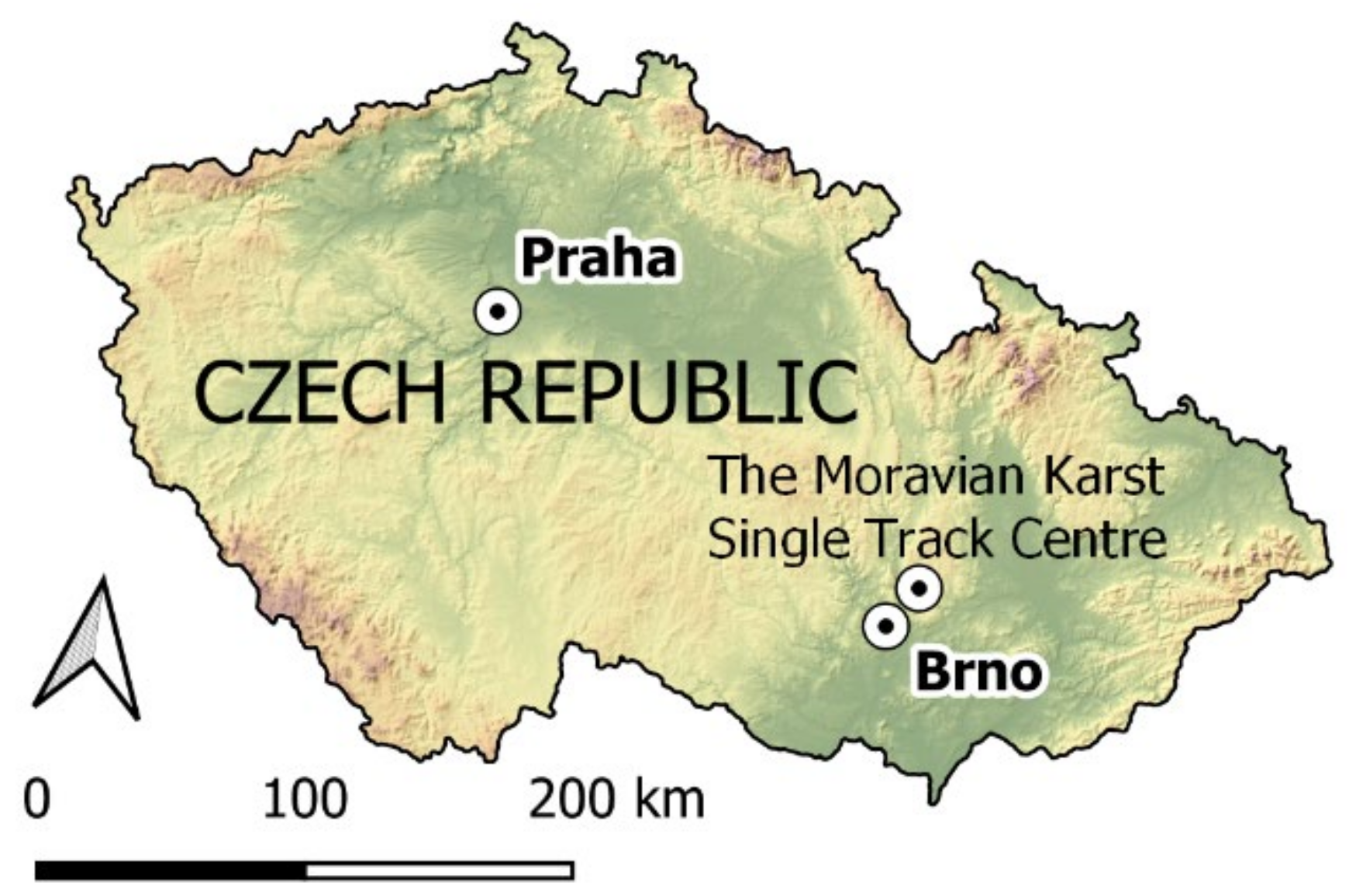
The Moravian Karst Single Track Centre was constructed in 2015 across 547.74 ha at the Training Forest Enterprise Masaryk Forest Křtiny (TFE), which is an organisational part of the Mendel University in Brno (MENDELU), with the aim of directing the activities of mountain bike visitors to specialised narrow trails. The TFE is located near Brno in the South Moravian region and manages all together a forest area of 10,492 ha. The representation and distribution of woody plants reflect the vegetation gradation and habitat conditions. Deciduous tree species (33% dominated by beech) cover 62% of the forest area, and 38% are covered by conifers (19% spruce). Sustainable forest management aims at management measures ensuring the fulfilment of forest ecosystem services and other functions in changing environmental and social conditions and optimal use of the production potential of forests, with particular regard to the needs of the university (teaching and research) and the public (recreation). The TFE closely collaborates with the Faculty of Forestry and Wood Technology MENDELU to offer experimental forest stands and other establishments for educational and research purposes.
Our aim was to determine whether bikers in the centre moved outside the site to use other forest roads or other parts of the forest or whether they stayed mostly in the trail area. For forest management purposes, we also investigated the quantitative movements of visitors in the Moravian Karst Single Track Centre and their time distribution to provide forest managers with information on land use at various times.
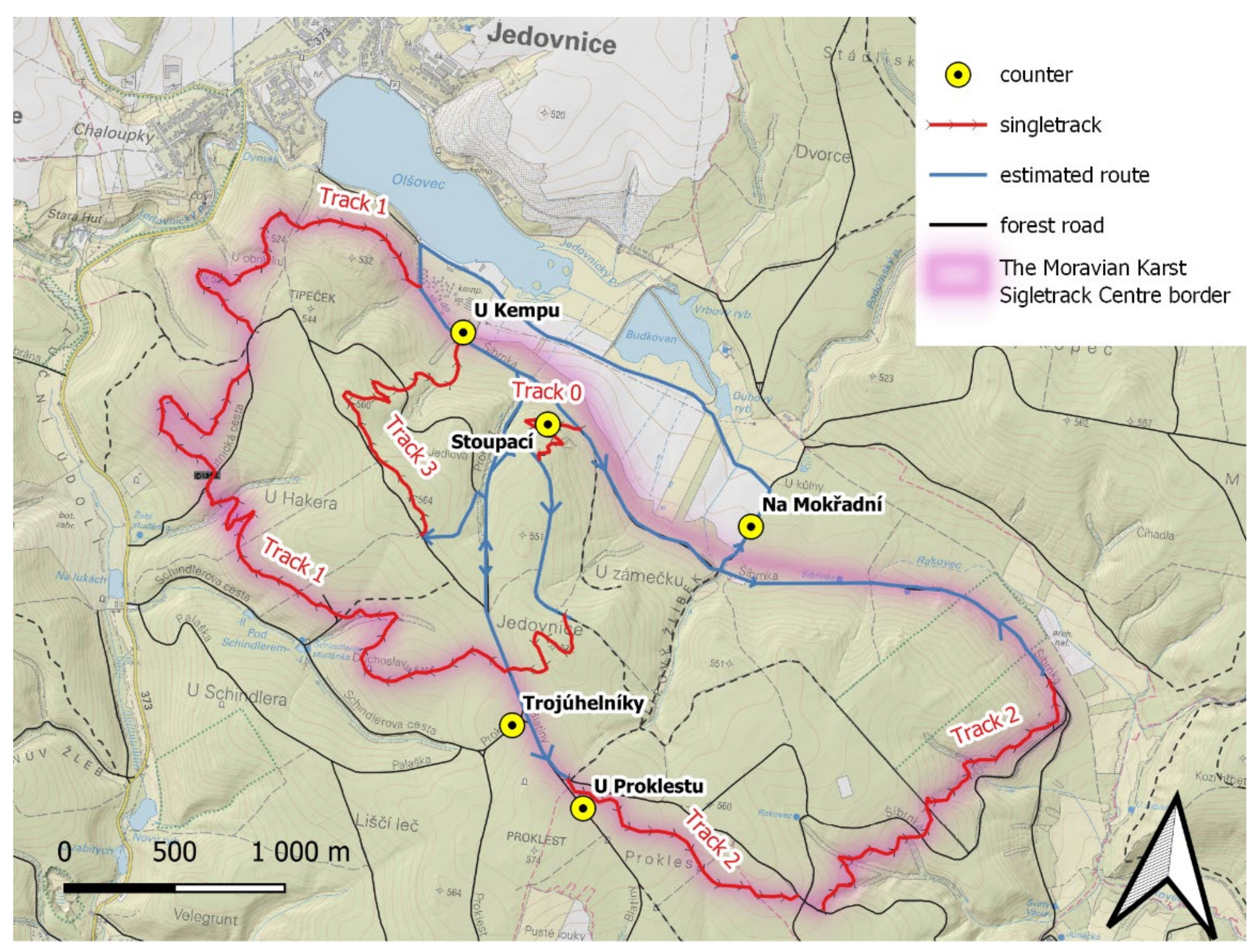
The four trails consist of single tracks that go through the forest stand and, partially, on forest roads in the northeast TFE part. The starting point for these trails is located near Camp Olšovec in Jedovnice, where there is a sport–recreation centre for mountain bikers (boarding place) with technical facilities. The single-track sections, which go directly through the forest stand, are referred to in the study as Track 0 (770 m), Track 1 (7250 m), Track 2 (3730 m) and Track 3 (2010 m) (Figure 1). The single tracks measure 13.8 km in total length and are connected by forest roads. The total length of all trails together with forest roads is 21.4 km.
The hypothetical assumption was that cyclists would only use the marked trail routes prepared for them to join a ride and would not leave the single-track area of 547.74 ha to go into the surrounding forest ecosystem. The single-track bike trails constructed in one part of the forest would be sufficiently attractive that they would not leave them, and the surrounding forest stands would be undisturbed by bikers. If this was not confirmed, the question would be: how many visitors left the area for other parts of the forest?
First, the method of monitoring cyclists in the selected area was decided, and the assumption of their direction of movement was made.
In cooperation with the monitoring coordinator of cyclists from the Partnership Foundation, two types of counters were chosen and locations suitable for placing them were selected. Their placement was agreed with the administrator of the Moravian Karst Single Track Centre, and the necessary facilities were leased.
Monitoring was performed for one month in the high season for cycling activity (15 June–15 July). The presence of visitors was monitored with respect to the time of day and whether the day was a working or non-working day.
Four locations were selected (i.e., U Kempu, Trojúhelníky, U Proklestu and Na Mokřadní) to install the first type of counter, Eco-counters, to cover the cyclist entry points to the trail area; their movements were captured further on the routes in the area (Figure 2). Thus, sensors were set-up to scan all incoming and outgoing visitors to the trail area.
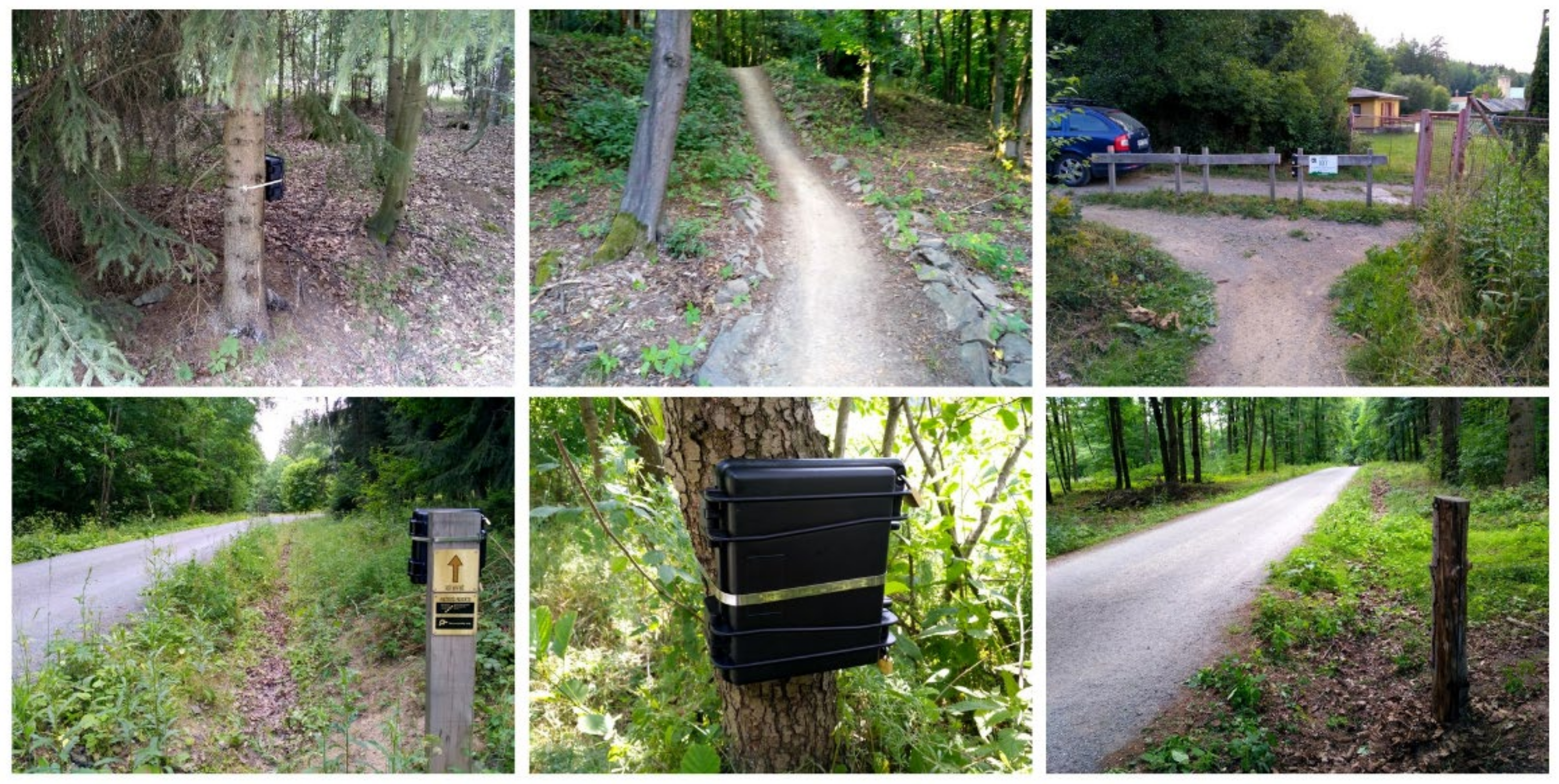
Counters were placed at narrow places so that cyclists could not ride past them side by side. They were mounted on trees next to the road or on a nearby pole if a tree was unavailable. The counters can measure reliably over four meters. The devices were locked and marked with a contact number to prevent them from being accidentally damaged by people. All counter locations were photographically documented (Figure 3).
An Eco-counter is a device for counting all users of a route (cyclists, pedestrians and cars). It has two sensors and can determine the direction of its target’s motion. The counters were manually calibrated to identify individual groups of visitors and a calibration coefficient was set to ensure the maximum validity of the collected data and minimise errors, i.e., manual calibration counts were performed to determine the numbers of individual users as cyclists, pedestrians or cars. An error can arise in wider places if cyclists ride close together. The counter then records them as one person. The calibration prevents this deficiency and, thus, ensures the maximum accuracy of the measured data. At each site, data were collected for eight hours per day. Data were collected continuously throughout the measurement period of six days. Subsequently, the counters were removed from each site, the data were downloaded and, using the calibration coefficient, calculated to the actual values of the individual participants and the direction of their travel. Due to the fact that this study focused on the movement of cyclists in the given area, the results subsequently analyse only the movements of cyclists.
We placed one of the second type of counter, a TRAFx Mountain Bike Counter, at Stoupací on Track 0 to discover whether cyclists used the ascending single-track bike trail to access downhill single tracks or whether they also used the surrounding forest road.
This counter responds to metal wheel parts, so it is able to detect bikes with a carbon frame. The width of the recording field was up to 1 m from the counter, so when installed in the middle of the track, it can cover a track up to 2 m wide. It was installed under the surface of the trail, hiding it from human eyes, minimising the risk of damage or vandalism.
Both types of counters consisted of a sensor that recorded the passage of a cyclist and were connected to the data unit, which stored the measured data and supplied power to the counter.
During the measurement phase, there was one month of continuous inspection and manual data collection. The Eco-Visio online application (https://www.eco-counter.com/applications; accessed on 20 October 2021) was used to download, analyse and implement monitoring-related data.
As single tracks are often represented as narrow paths following the shape of the terrain, with minimum influence on their surroundings, we focused on the real width of constructed single tracks in the Moravian Karst Centre. The width of single tracks is generally stated to be up to 1 m, which only relates to one bike track width of 0.8 m, but the total width varies depending on the single track’s inclination and the transverse slope of the terrain. It is necessary to take into account the cut-and-fill slopes and take as the width the entire width of the single-track formation. This greatly changes the total area take-up as evidenced by the results of our investigation.
One of the aims of this research was to determine a suitable and sustainable size for a single-track area for mountain biking, allowing for other visitors, timber production and other forest functions, as there is now a great demand for this type of sports activity in the forest environment.
For comparison, we chose 10 such centres abroad. Five of these were in the UK, where this issue is historically captured systemically and on the basis of a national strategy. Trails were chosen in Wales, which has been written about in the sense of “here it all began, 25 years ago we saw the start of the trail centre revolution, and it was here in Wales. Coed y Brenin led the way in setting up waymarked trails specifically for mountain biking” (https://www.mbwales.com/2016/07/18/trails-centres-began/; accessed on 20 October 2021). We can describe these trails as closed circles, often far from large towns and habitations. The location of the trails in forest stands was not a condition, but most were located in forest. To select suitable single-track areas, a Welsh government website, Mountain Bike Wales (https://www.mbwales.com; accessed on 20 October 2021), was used. The site promotes mountain biking and provides information about each site, including maps. Five centres were selected: Abercarn, Afan, Brechfa, Cw Merfyn and Ganllwyd.
The other five trail areas examined were in Denmark, on slightly hilly terrain in suburban forests, so their location and the shape of terrain were more comparable with the Moravian Karst Single Track Centre. The Danish facilities were located close to areas of habitation; being within forest stands was a condition of their selection. The Mountain Bike Project website (https://www.mtbproject.com; accessed on 20 October 2021) was used to select five suitable areas: Djævlesporet, Egebjerg, Kongshøj, Silkeborg and Vodskov.
We did not compare the size of the areas, but trail density was established for the total length of all trails and the efficiency established for the trail distribution. Specially, the efficiency provided us with information about single-track land use and based on this value, it is possible to decide whether it is appropriate to further expand the single-track bike centre or to have single tracks more concentrated if needed according to the demand.
The total area of the biking amenity was taken as that enclosed by the trails themselves and forest roads that were used as connecting lines between the trails and forest roads leading to the start of the trails from the car park.
The total length of the trails was calculated as the length of all trails, including forest roads, so that the trails calculated formed a connected whole. None of the trails or their parts were counted twice, although some sections of forest roads could be used as part of several trail routes.
The density of trails within a facility was established as the total length of the trails divided by the area of the facility and expressed in m/ha.
The density H is given by the Equation (1):
where: D is the total length of the trail network (m), S is the accessed area (ha).
As the parameters do not provide any information on the trail network’s distribution, a parameter for trail efficiency was added.
The efficiency is given as the proportion between the average geometric (shortest) distance from a regular geometric 10 ha square network (grid) and the theoretical distance, the calculation of which was based on the ideal regular distribution of the trails in the area according to Equation (2).
where Dt is the theoretical distance (m) calculated as the average distance due to the optimal distribution of trails (Figure 4) in the accessed area and depending on the trail density H according to Equation (3).
In addition, the geometric distance, Dg, represents the direct distance from the centre point of a regular geometric 10 ha square grid to the trail. Its average value (Equation (4)) depends on the trail distribution and is generally higher than the theoretical distance.
To analyse the trail areas, maps on the OpenStreetMap WMS server were used in the QGIS application environment. The geometric distances from grid points were determined using QGIS software and the vector analysis tool “distance to nearest hub”. The same analyses were performed for the Moravian Karst Single Track Centre for comparison.
3. Results
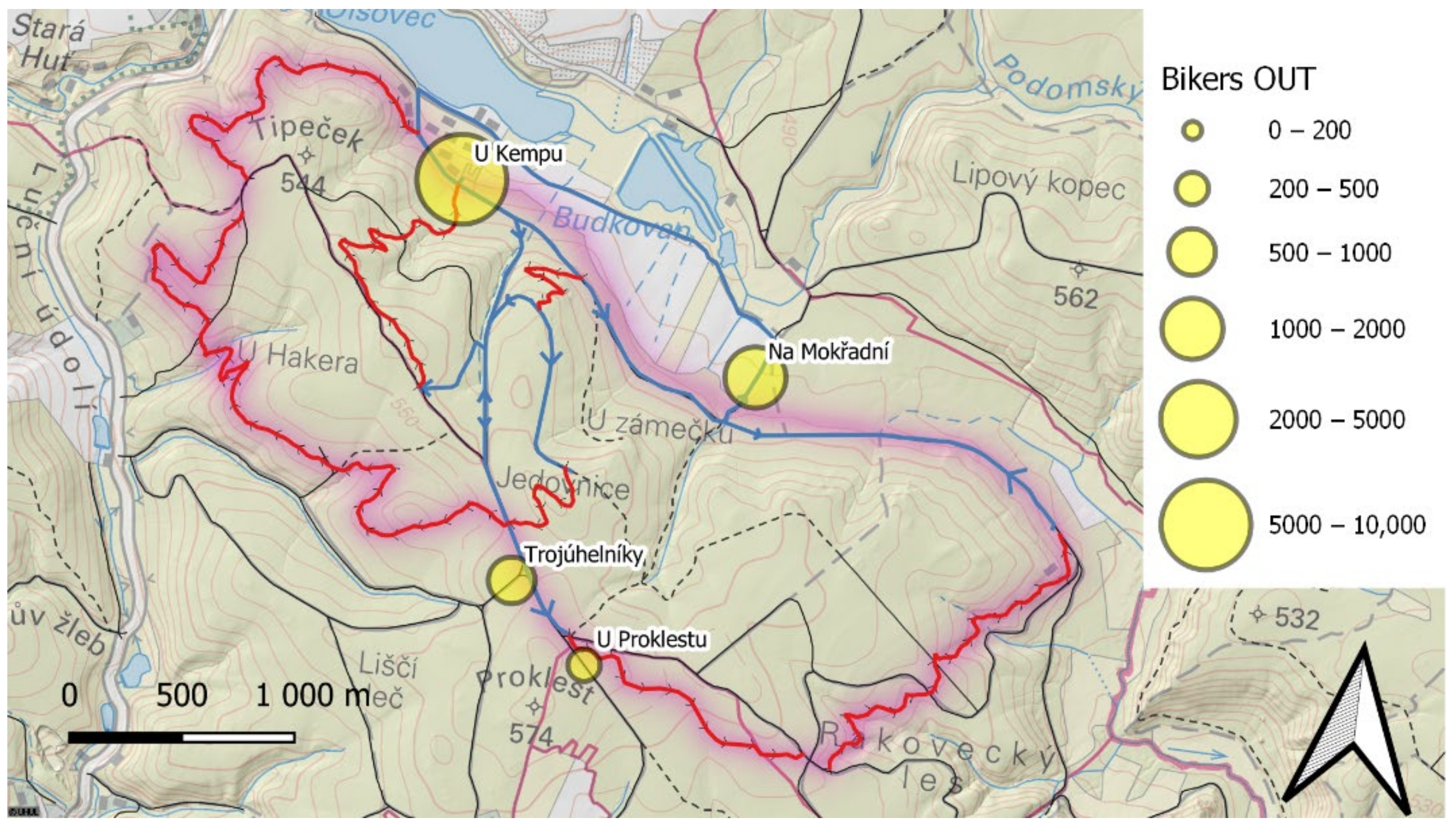
The comparison of the monitored visitor entry points into the Moravian Karst Single Track Centre showed (Table 1) large differences in total attendance in the monitored period. The site at U Kempu, located on a forest road at the entrance to the Training Forest Enterprise Křtiny, MENDELU by the Jedovnice Olšovec Lake, dominated attendance figures with 21,559 visits. Another monitored site near Olšovec at Na Mokřadní recorded a significantly lower value of 4172 visitors. But the fewest visitors were recorded on the opposite side at Trojúhelníky (2440) and U Proklestu (1070), which is the side from which people leave the Moravian Karst Single Track Centre to visit other parts of Forest Training Entrprice Křtiny.
Focusing only on cyclists (e.g., data cleaned of vehicles and pedestrians using calibration counting), we counted 9714 cyclists at U Kempu travelling towards Jedovnice; going in the opposite direction, the figure was 9599 cyclists. On the Jedovnice side at Na Mokřadní, it was 1807 cyclists in and 1207 out. On the opposite side of the Centre, the counters at Trojúhelníky and U Proklestu recorded only 1133 cyclists riding into the area and 927 riding out (Table 2).
From these numbers, we can conclude that 92% of cyclists stayed at the Moravian Karst Single Track Centre and the construction of single-track trails in response to the need for controlled recreation fulfilled its purpose.
At most locations, Saturday was the busiest day. The exception was at U Proklestu, where Monday (65) and Sunday (162) were the busiest days. This shows that this route was favoured mostly by trekking cyclists, who mainly used the forest roads at the Centre.
The average daily visit rate at the sites corresponds to the total visit rate. At all localities, the number of visitors on non-working days was less than 2/3 of total attendance.
The maps (Figure 5 and Figure 6) and measurements show that bikers used the marked trail route. The main purpose for them was to enjoy these trails. The existing three single tracks go through the forest stand and, partially, on forest roads, so bikers do not need to use other forest roads.
From a total of 12,654 incoming cyclists, 8522 used single-track 0 instead of the adjacent forest road. This gives us interesting information that bikers use single tracks rather than ascending forest roads to reach the top of the downhill single tracks near U Proklestu.
The single-track area was mostly visited during daylight hours, which is consistent with the guidelines for visitors from trail managers. The peak hours are given in Table 3.
The real width of most constructed single tracks, taking cut-and-fill slopes into account, fell in the width category 1–2 m, with 2–3 m the next most common as seen in Table 4.
The 770 m Track 0 represents a part that is common to all of the trails and is used to access downhill single-tracks 1, 2 and 3. The section has a long rise that makes up 83% of the trail length with variable width including cut-and-fill slopes of between 1.0 and 3.0 m. The mean total width of the road formation is 1.8 m, with 77% of the trail length being wider than 1.0 m (Table 4).
Track 1 has the character of a ridge trail with a balanced ascent and descent ratio going over the north-western slopes of a peak. The total length is 7250 m, and the width ranges from 0.7 to 9.2 m with a mean of 1.8 m. For 435 m of the trail, the width is greater than 3.0 m (Table 4).
Track 2 has a total length of 3730 m and resembles the main downhill part of a single track. The trail is 1.0–6.2 m wide, with a mean of 2.4 m. Sixty-six percent of the trail length is wider than 2.0 m, and for a length of 535 m, the trail is wider than 3.0 m (Table 4).
Track 3 first runs along the ridge forest road, diverging from it after approximately 600 m. The total section length is 2010 m, and the trail width ranges between 0.8 and 6.4 m (Table 4) with a mean of 2.1 m. For 315 m, the width of the trail is greater than 3.0 m.
Based on our measurements, we can conclude that the width of all single tracks over their entire length is greater than 1.0 m. On average, 90% of the trail lengths are 1.0–3.0 m wide (Table 4). Almost 1.4 km of the trail is wider than 3.0 m (11% of the total length of the single track located in the forest stand).
The characteristic parameters of biking areas in Wales and Denmark are compared in Table 5 with those of the Moravian Karst Single Track Centre with its total area of 547.74 ha, total trail length of 21,365 m, density of 39 m/ha and efficiency of 40%.
4. Discussion
In previous years, data from the counter located on Track 0 were compared. According to Olišarová et al. [12], the most frequented months of 2017 and 2018 were July and August. A comparison of the study routes in the area showed a large difference in total attendance in the monitored period. In July 2017, a total of 9558 cyclists rode past the counters, and the following year (2018) showed 9170 entries. The data from this year in the first half of July show a total of 5056 passages.
There was a wide range of holidaymakers in the area. The highest attendance was recorded at U Kempu, near the camp gate. Nearly 90% of visitors recorded there were cyclists. On the contrary, the smallest number of visitors was counted at U Proklestu, where the number of cyclists was less than 50%. Almost two-thirds of visitors came to the area on a non-working day, while during the week only 1/3 were in the area.
There are a large number of researchers and university employees at the locality, many of whom come by car. The most frequent passages were recorded by the counter at Trojúhelníky, probably because this road connects to utility road number 373 leading out from the area to another part of the Training Forest Enterprise Křtiny MENDELU.
According to Olišarová et al. [12], some visitors travelled one route several times, others have tactically chosen their way according to their abilities and skills, as each route differs in the difficulty of the terrain and elevation.
The project has proven that visitors stay in the single-track area, and very few go on to adjacent locations.
It is necessary to realise that urban forests are often popular sites for recreational activities such as hiking, biking and motorised recreation. This can result in the formation of extensive trail networks, fragmenting vegetation into patches separated by modified edge effects and, ultimately, contributing to the degradation of the ecosystem, and management should seek to minimise the creation of informal trails by hardening popular routes, instigating stakeholder collaboration and centralising visitor flow [31]. This statement can be supported by our findings that the regulation of bikers’ movements by controlled recreation fulfilled its objective and works. [31] adds, the forest lost to informal biking and hiking trails reached an area of 5%. The trail distribution in a single-track bike trail centre, evaluated by trail efficiency, can help to make a decision regarding new single-track bike trail design in a bike centre or its further development if needed. Informal trails generally had worse surface conditions and were poorly designed and located. Per site, formal and informal trails resulted in similar loss of forest strata, with wider trails resulting in greater loss of forest [32]. Choosing the right corridor for a single-track lay-out according to transverse slope terrain can minimise the width of single-trail formations. In [33], the authors present a study where they analysed the spatial overlap and social conflicts between mountain bikers and runners. This can help managers and decision makers design proper infrastructure for outdoor activities. Strategic management errors can be avoided by knowing user preferences and by offering improved conditions that meet the expectations and needs of different user groups. One of the reasons why we constructed single-track bike trails at TFE MENDELU was the same visible experience regarding conflict among groups of forest visitors, and we can state by this research that offering improved conditions for a leisure outdoor activity at a locality will keep visitors onside.
5. Conclusions
The presence of single tracks attracts mountain bikers who are willing to make a longer journey to pay their visit. Their goal is to enjoy the adrenaline-rush bike ride that single tracks unquestionably provide. Therefore, they do not need to venture into a surrounding area of the forest ecosystem and, thus, do not interfere with forest management or other interests in the rest of the forest. There are various groups of forest visitors with different reasons for moving deeper into the forest ecosystem such as pedestrians, runners, families with children and people walking dogs. All these recreational functions are provided alongside forest management activities focusing mainly on timber production. The construction of bike trails with single-track parts makes it possible to manage the movements of bikers on a specific trail (i.e., single tracks). As seen from this study, cyclists usually follow the marked routes and do not affect the surrounding forest.
The assumption of the narrow design of a single trail up to 1 m in width applied only in the case of a transverse slope of the terrain of up to approximately 16%. However, to increase the attractiveness, the trails are traced through a morphologically hilly area. Only 35% of the Track 3 length meets the 1 m width assumption due to the fact of its location on the plateau. All other trails are actually much wider. With an increasing transverse slope, the overall width increases rapidly. The most common width, in the range of 1–2 m, is situated in transverse terrain slopes of 16–42%. Approximately 20–30% of the trail lengths are traced in transverse slopes of 42–50%, resulting in an overall width of 2–3 m.
When comparing the land use of bike centres, as we can see, the Danish bike trail centres are smaller than those in Wales, which are located at remote sites, and the Moravian Karst Single Track Centre, but the design and density of their layout means the area is better used. When an extension of the bike centre is required, the efficiency parameter can help forest owners decide whether to extend trails inside or outside of the centre. When the efficiency parameter is less than 50%, construction inside should be recommended. At the same time, trails which divert bikers away from forest roads and avoid crossings of single tracks with forest roads should be given preference. The aim should be to achieve a uniform distribution of trails so that the forest ecosystem in the related parts of a single-track centre is not impaired.
It is clear from the collected data that the presence of individual routes is beneficial for the regulation of cyclists on forest paths seeking excitement; at the same time, there is no conflict with other visitors, who are expecting different experiences from visiting the forest.
The practical benefits of cycling monitoring for forest managers can be summarised as:
- Use for the controlled movement of bikers in the forest area.
- Planning measures to prevent/limit forestry management collision with forest visitors.
- Planning for conservation measures.
- Maintenance priority planning for both single tracks and used forest roads.
- Proposed solutions and recommendations in terms of land development.
- Reporting traffic data to the media for positive public relations.
Author Contributions
P.H. initiated the investigation, drafted and carried out the methodology and analysis and finalized the manuscript; P.P. carried out the analysis and visualized pictures L.O. carried out the terrain investigation and drafted the manuscript. All authors have read and agreed to the published version of the manuscript.
Funding
The research was funded by Mendel University in Brno (grant number: LDF_VP_2018029).
Institutional Review Board Statement
Ethical review and approval were waived for this study, due to anonymity of this study and no harm or collection of ethical data on humans.
Informed Consent Statement
Not applicable.
Data Availability Statement
The data are available and stored by the correspondent author.
Conflicts of Interest
The founding sponsor, Mendel University in Brno, had no role in the collection, analyses or interpretation of data; in the writing of the manuscript; in the decision to publish the results.
References
- Fialová, J.; Březina, D.; Žižlavská, N.; Michal, J.; Machar, I. Assessment of visitor Preferences and Attendance to Singletrails in the Moravian Karst for the Sustainable Development Proposals. Sustainability 2019, 11, 3560. [Google Scholar] [CrossRef] [Green Version]
- Pickering, C.M.; Rossi, S. Mountain biking in peri-urban parks: Social factors influencing perceptions of conflicts in three popular National Parks in Australia. J. Outdoor Recreat. Tour. 2016, 15, 71–83. [Google Scholar] [CrossRef]
- Quinn, M.; Chernoff, G. Mountain Biking: A review of the Ecological Effects; Parks Canada, National Office, University of Calgary: Calgary, AB, Canada, 2010; p. 42. [Google Scholar]
- Koemle, D.B.A.; Morawetz, U.B. Improving mountain bike trails in Austria: An assessment of trail preferences and benefits from trail features using choice experiments. J. Outdoor Recreat. Tour. 2016, 15, 55–65. [Google Scholar] [CrossRef]
- Wilkes-Allemann, J.; Putz, M. Governance of forest recreation: Analysing the case of mountain bike trails. Schweiz. Z. Forstwes. 2017, 168, 321–328. [Google Scholar] [CrossRef] [Green Version]
- Cordell., H.K.; Lewis, B.; McDonald, B. Long-term outdoor recreation participation trends. In Proceedings of the Fourth International Outdoor Recreation Tuorism Trends Symposium and the 1995 National Recreation Resource Planning Conference, Saint Paul, MN, USA, 14–17 May 1995; pp. 35–38. [Google Scholar]
- Zahradník, D.; Banas, M.; Jirásková, E. Back and front of visitor Monitoring-Examples of good and less successful visitor monitoring in the Czech Protected areas. J. Landsc. Manag. 2012, 3, 14–19. [Google Scholar]
- Navrátil, J.; Knotek, J.; Pícha, K.; Fialová, J. Gentle Tourism in Large Protected Areas of Nature: South Bohemia and Šumava; Publishing House JIH: České Budějovice, Czech Republic, 2014; 143p. [Google Scholar]
- Březina, D.; Michal, J.; Fialová, J. Monitoring of visitor arrivals at the area of Městské lesy Hradec Králové a. s. using field counting devices. In Proceedings of the Public Recreation and Landscape Protection—With Sense Hand in Hand, Křtiny, Czech Republic, 13–15 May 2019; Mendel University in Brno: Brno, Czech Republic, 2019; pp. 250–253. [Google Scholar]
- Březina, D.; Fialová, J.; Michal, J.; Slováčková, H. The methodology of quantification the influence of Hradec Králové city forests plc. On the regional economics. In SilvaNet—WoodNet 2018: Proceedings Abstracts of Student Scientific Conference; Mendel University in Brno: Brno, Czech Republic, 2018; pp. 71–72. [Google Scholar]
- Kluge, T. Flow-, Singletrail und das Grundrecht auf Naturgenuss. In Proceedings of the Conference Dialogforum Wald: Wald Freizeit, Erholung, Gesundheit, Berlin, Germany, 20–21 April 2016. [Google Scholar]
- Olišarová, L.; Kala, L.; Hrůza, P. Moving of visitors single trail Moravian Karst on the forestry roads in Křtiny. In Proceedings of the Public Recreation and Landscape Protection—With Sense Hand in Hand, Křtiny, Czech Republic, 13–15 May 2019; Mendel University in Brno: Brno, Czech Republic, 2019; pp. 254–257. [Google Scholar]
- IMBA. Available online: https://www.imba.com/explore-imba/resource-hub (accessed on 2 April 2021).
- Lynn, N.A.; Brown, D. Effect of recreational use impact on hiking experiences in natural areas. Landsc. Urban Plan. 2003, 64, 77–87. [Google Scholar] [CrossRef] [Green Version]
- Majnoonian, H. Discussion of Parks and Green Spaces and Promenades; Department of Parks and Green Spaces of Tehran City-Iran Press: Tehran, Iran, 1995; 251p. [Google Scholar]
- Laval, D.; Umar, M.A.N.; Balogun, A.L. A Geographic Information System and Multi-Criteria Decision Analysis in Proposing New Recreational Park Sites in Universiti Teknologi Malaysia. Mod. Appl. Sci. 2011, 5, 39–55. [Google Scholar] [CrossRef]
- Šlezingr, M.; Uhmannová, H. The Revitalization of Rivers—Bankside Trees and Shrubs. In Proceedings of the Public Recreation and Landscape Protection—With Man Hand in Hand? Křtiny, Czech Republic, 13–15 May 2019; Mendel University in Brno: Brno, Czech Republic, 2019. [Google Scholar]
- Gül, A.; Gezer, A. Modeling proposal for the selection of urban forest location and its evaluation using Isparta city example. In Proceedings of the First National Urban Forestry Congress in Turkey, Ankara, Turkey, 9–11 April 2004; pp. 365–382. [Google Scholar]
- Hagen, S.; Boyes, M. Affective ride experiences on mountain bike terrain. J. Outdoor Recreat. Tour. 2016, 15, 89–98. [Google Scholar] [CrossRef]
- Pickering, C.; Ansong, M.; Wallace, E. Experimental assessment of weed seed attaching to a mountain bike and horse under dry conditions. J. Outdoor Recreat. Tour. 2016, 15, 66–70. [Google Scholar] [CrossRef]
- Schneider, J.; Fialová, J.; Vyskot, I. Landscape Recreology I; Mendel University in Brno: Brno, Czech Republic, 2008; 140p. [Google Scholar]
- Brown, K.M. The role of belonging and affective economies in managing outdoor recreation: Mountain biking and the disengagement tipping point. J. Outdoor Recreat. Tour. 2016, 15, 34–46. [Google Scholar] [CrossRef]
- Zajc, P.; Berzelak, N. Riding styles and characteristics of rides among Slovenian mountain bikers and management challenges. J. Outdoor Recreat. Tour. 2016, 15, 10–19. [Google Scholar] [CrossRef]
- Rusterholz, H.P.; Baur, B. Characterization and preferences of the visitors in three areas of a recreation forest: Results of a survey in the forest of Allschwil. Schweizerische Zeitschrift Forstwesen. 2003, 154, 397–404. [Google Scholar]
- The Parliament of the Czech Republic. Forest Act and Amendments to Certain Acts (Forest Act); Act No. 289/1995 Coll; on Forests and on Amendments to Certain Acts (Forest Act); The Parliament of the Czech Republic: Prag, Czech Republic, 1995.
- Hrůza, P. Making the Forest Accessible and Its Complex Concept; Mendel University in Brno: Brno, Czech Republic, 2014; 123p. [Google Scholar]
- Hrůza, P. Technologies for the reinforcement of forest timber hauling roads and their recreational suitability. In Proceedings of the Public Recreation and Landscape Protection—With Man Hand in Hand, Křtiny, Czech Republic, 1–3 May 2016; Mendel University in Brno: Brno, Czech Republic, 2016; pp. 238–241. [Google Scholar]
- Wilkes-Allemann, J.; Putz, M.; Hirschi, C.; Fischer, C. Conflict situations and response strategies in urban forests in Switzerland. Scand. J. For. Res. 2015, 30, 204–216. [Google Scholar] [CrossRef]
- Newsome, D.; Stender, K.; Annear, R.; Smith, A. Park management response to mountain bike trail demand in South Western Australia. J. Outdoor Recreat. Tour. 2016, 15, 26–34. [Google Scholar] [CrossRef]
- Mann, C.; Absher, J.D. Recreation conflict potential and management implications in the northern/central Black Forest Nature Park. J. Environ. Plan. Manag. 2008, 513, 363–380. [Google Scholar] [CrossRef]
- Ballantyne, M.; Gudes, O.; Pickering, C.M. Recreational trails are an important cause of fragmentation in endangered urban forests: A case-study from Australia. Landsc. Urban Plan. 2014, 130, 112–124. [Google Scholar] [CrossRef] [Green Version]
- Ballantyne, M.; Pickering, C.M. Differences in the impacts of formal and informal recreational trails on urban forest loss and tree structure. J. Environ. Manag. 2015, 159, 94–105. [Google Scholar] [CrossRef] [PubMed] [Green Version]
- Santos, T.; Mendes, R.N.; Vasco, A. Recreational activities in urban parks: Spatial interactions among users. J. Outdoor Recreat. Tour. Res. Plan. Manag. 2016, 15, 1–9. [Google Scholar] [CrossRef]
Figure 1.
Location of the study area the Moravian Karst Single Track Centre in the Czech Republic.

Figure 2.
Locations of counters for data measuring in the Moravian Karst Single Track Centre.

Figure 3.
Examples of counter installation.

Figure 4.
Theoretical distance, Dt, due to the optimal trail distribution in the forest access area and trail density, H 20 m/ha.
Figure 4.
Theoretical distance, Dt, due to the optimal trail distribution in the forest access area and trail density, H 20 m/ha.

Figure 5.
Number of cyclists in the direction into the area.

Figure 6.
Number of cyclists in the direction out of the area.


Table 1.
Overall monitoring results of visitors on selected forest roads in the Training Forest Enterprise Křtiny MENDELU during the period 15 June–15 July (calibrated data).
Table 1.
Overall monitoring results of visitors on selected forest roads in the Training Forest Enterprise Křtiny MENDELU during the period 15 June–15 July (calibrated data).
| Locality | Total Attendance | Average Daily Attendance | ||||
|---|---|---|---|---|---|---|
| Total Records | Working Days | Non-Working Days | Daily Average | Working Days | Non-Working Days | |
| U Kempu | 21,559 | 7107 | 14,452 | 695 | 374 | 1204 |
| Stoupací | 8522 | 2566 | 5615 | 264 | 135 | 468 |
| Na Mokřadní | 4172 | 1757 | 2415 | 135 | 92 | 201 |
| Trojúhelníky | 2440 | 1443 | 1034 | 79 | 64 | 102 |
| U Proklestu | 1070 | 539 | 531 | 35 | 28 | 44 |
Table 2.
Number of cyclists according to each counter.
| U Kempu | Stoupací | Trojúhelníky | U Proklestu | Na Mokřadní | |
|---|---|---|---|---|---|
| Cyclists | |||||
| In * | 9714 | 8522 | 938 | 195 | 1807 |
| Out ** | 9599 | - *** | 672 | 255 | 1127 |
* Direction into the area. ** Direction out the area. *** Counter on the single-track Stoupací - bikers counted in one direction.
Table 3.
Visitor layout by peak hours.
| Locality | Peak Hours | In General |
|---|---|---|
| U Kempu | 11:00–12:00; 16:00–17:00 | 10:00–18:00 |
| Stoupací | 10:00–12:00 | 9:00–17:00 |
| Trojúhelníky | 10:00–11:00; 14:00–16:00 | 10:00–18:00 |
| U Proklestu | 10:00–12:00; 15:00–18:00 | 10:00–18:00 |
| Na Mokřadní | 14:00–16:00; 17:00–18:00 | 10:00–19:00 |
Table 4.
Trail width parameters.
| Width (m) | Ratio of Total Single-Track Length (%) | ||||
|---|---|---|---|---|---|
| Limit Transverse Terrain Slope (%) | Trail 0 | Trail 1 | Trail 2 | Trail 3 | |
| <1 | <16 | 0.0 | 0.2 | 35.4 | 0.0 |
| 1–2 | 16–42 | 76.9 | 70.2 | 21.8 | 61.2 |
| 2–3 | 42–50 | 20.7 | 22.7 | 28.3 | 23.1 |
| 3–4 | 50–53 | 1.7 | 5.3 | 11.1 | 11.5 |
| >4 | >53 | 0.7 | 1.6 | 3.3 | 4.1 |
| Total length (%) | 100.0 | 100.0 | 100.0 | 100.0 | |
Table 5.
Characteristics of the single-track areas compared.
| Country | Trail | Area (ha) | Length (m) | Density (m/ha) | Efficiency (%) |
|---|---|---|---|---|---|
| Wales | Abercarn | 403.10 | 26,820 | 67 | 38 |
| Wales | Afan | 1661.42 | 100,467 | 60 | 37 |
| Wales | Brechfa | 594.34 | 44,352 | 75 | 29 |
| Wales | Cw Merfyn | 1381.55 | 35,062 | 25 | 29 |
| Wales | Gannlwyd | 1154.51 | 60,824 | 53 | 48 |
| Denmark | Djaevlesporet | 157.81 | 13,349 | 85 | 39 |
| Denmark | Egebjerg | 42.43 | 10,440 | 246 | 47 |
| Denmark | Kongshoj | 49.30 | 8255 | 167 | 47 |
| Denmark | Silkeborg | 201.38 | 13,806 | 69 | 32 |
| Denmark | Vodskov | 108.67 | 12,254 | 113 | 47 |
| Czechia | Moravia Karst | 547.74 | 21,365 | 39 | 40 |
Publisher’s Note: MDPI stays neutral with regard to jurisdictional claims in published maps and institutional affiliations. |
© 2021 by the authors. Licensee MDPI, Basel, Switzerland. This article is an open access article distributed under the terms and conditions of the Creative Commons Attribution (CC BY) license (https://creativecommons.org/licenses/by/4.0/).
Share and Cite
MDPI and ACS Style
Hrůza, P.; Pelikán, P.; Olišarová, L. Single-Track Bike Trails in the Moravian Karst as Part of Forest Recreation. Forests 2021, 12, 1601. https://0-doi-org.brum.beds.ac.uk/10.3390/f12111601
AMA Style
Hrůza P, Pelikán P, Olišarová L. Single-Track Bike Trails in the Moravian Karst as Part of Forest Recreation. Forests. 2021; 12(11):1601. https://0-doi-org.brum.beds.ac.uk/10.3390/f12111601
Chicago/Turabian StyleHrůza, Petr, Petr Pelikán, and Lucie Olišarová. 2021. "Single-Track Bike Trails in the Moravian Karst as Part of Forest Recreation" Forests 12, no. 11: 1601. https://0-doi-org.brum.beds.ac.uk/10.3390/f12111601
Note that from the first issue of 2016, this journal uses article numbers instead of page numbers. See further details here.