
Acceptance of New Land-Use Activities by Hmong and Khmu Ethnic Groups: A Case Study in Northern Lao People’s Democratic Republic


Abstract
:1. Introduction
2. Study Site and REDD+ Project Description
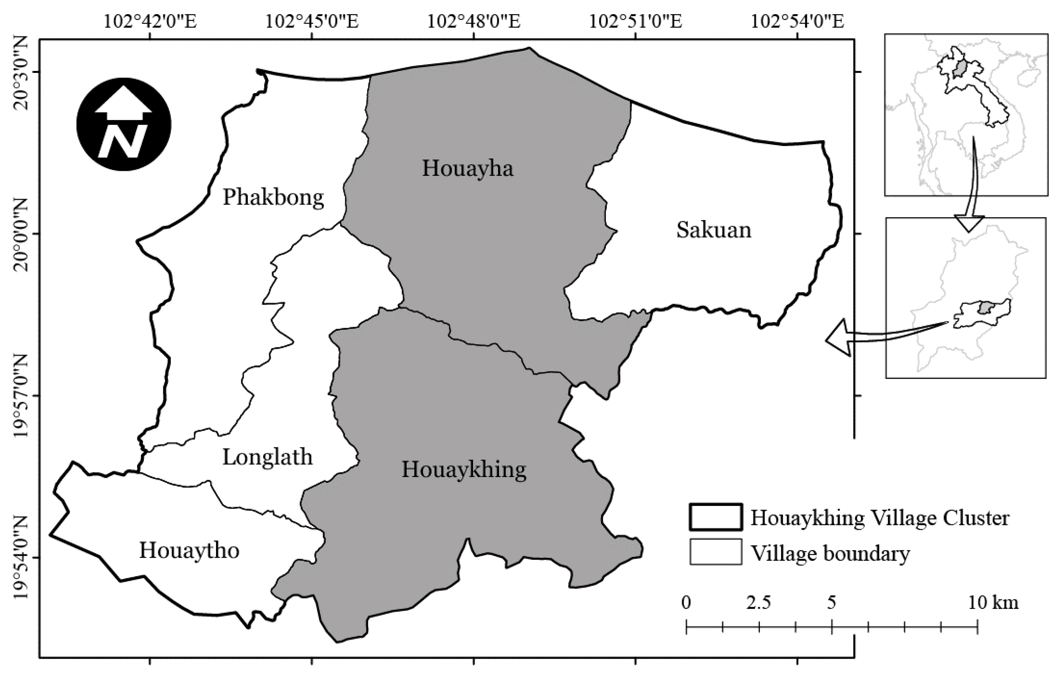
2.1. Study Site Description
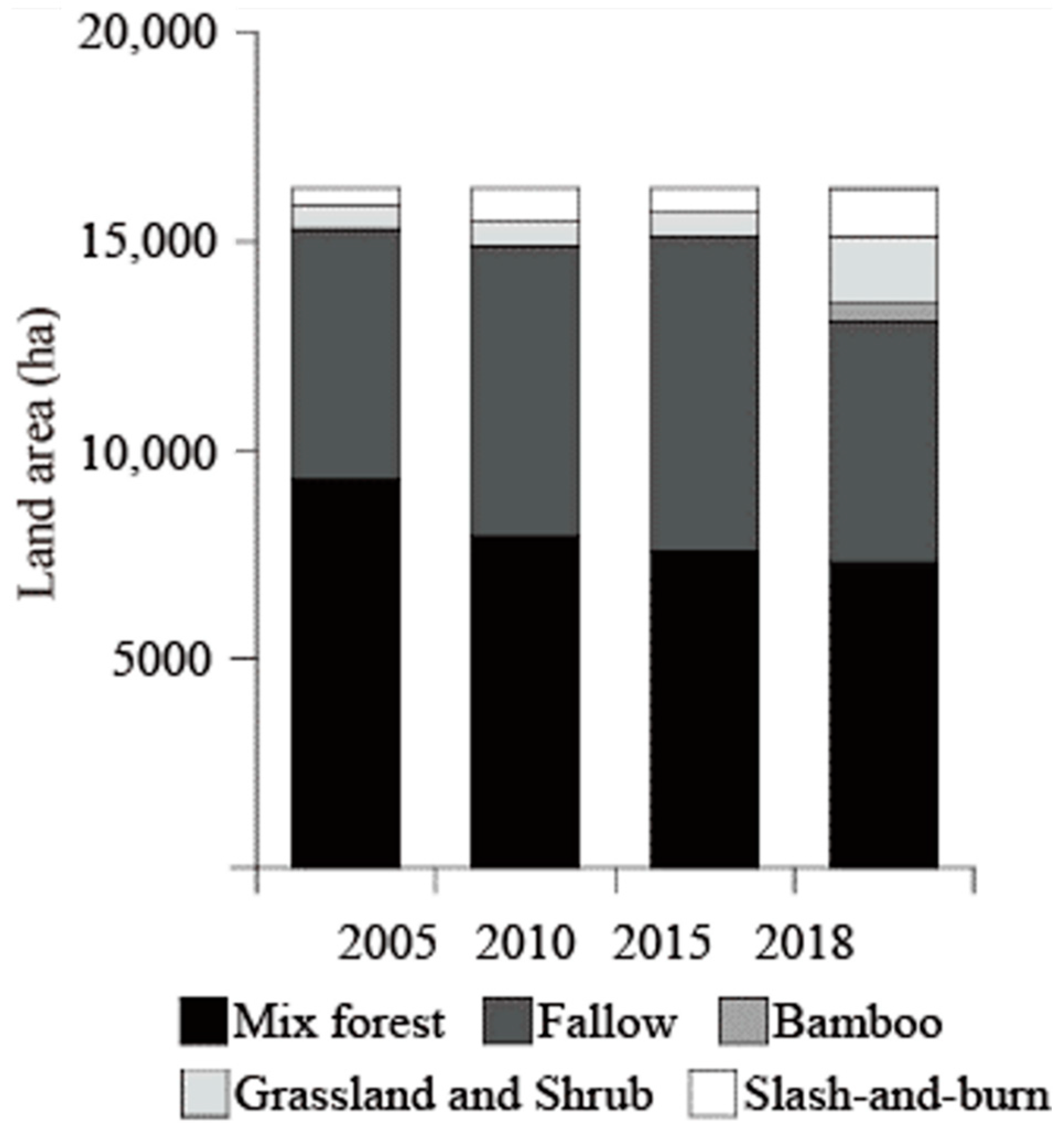
2.2. Implementation of New Land-Use Activities
3. Materials and Methods
3.1. Questionnaire-Based Socioeconomic Survey
3.2. Data Analysis
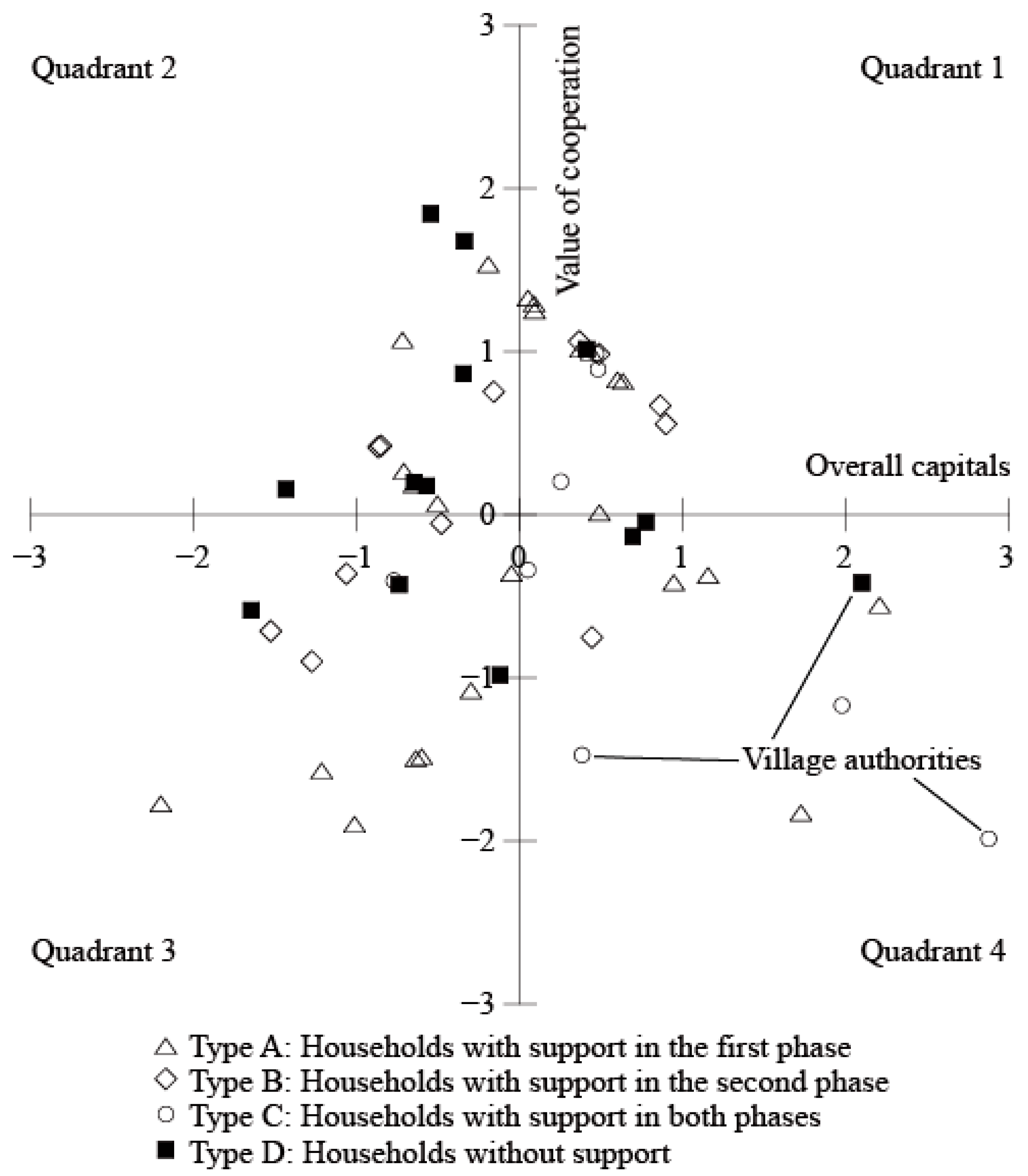
4. Results
4.1. Acceptance of Livestock Raising and Related Land Assets
4.2. Current Status of the Community
5. Discussion
Author Contributions
Funding
Institutional Review Board Statement
Informed Consent Statement
Data Availability Statement
Acknowledgments
Conflicts of Interest
References
- Intergovernmental Panel on Climate Change, Climate Change and Land: An IPCC Special Report on Climate Change, Desertification, Land Degradation, Sustainable Land Management, Food Security, and Greenhouse Gas Fluxes in Terrestrial Ecosystems; Intergovernmental panel on Climate Change: Geneva, Switzerland, 2019.
- Seymour, F.; Harris, N.L. Reducing tropical deforestation. Science 2019, 365, 756–757. [Google Scholar] [CrossRef] [Green Version]
- Curtis, P.G.; Slay, C.M.; Harris, N.L.; Tyukavina, A.; Hansen, M.C. Classifying drivers of global forest loss. Science 2018, 361, 1108–1111. [Google Scholar] [CrossRef] [PubMed]
- McDermott, C.L.; Coad, L.; Helfgott, A.; Schroeder, H. Operationalizing social safeguards in REDD+: Actors, interests and ideas. Environ. Sci. Policy 2012, 21, 63–72. [Google Scholar] [CrossRef]
- United Nations Framework Convention on Climate Change, The Cancun Agreements: Outcome of the Work of the Ad Hoc Working Group on Long-Term Cooperative Action under the Convention (Decision 1/CP.16). Available online: https://unfccc.int/resource/docs/2010/cop16/eng/07a01.pdf (accessed on 10 March 2021).
- Ehara, M.; Hyakumura, K.; Yokota, Y. REDD+ initiatives for safeguarding biodiversity and ecosystem services: Harmonizing sets of standards for national application. J. For. Res. 2014, 19, 427–436. [Google Scholar] [CrossRef]
- Visseren-Hamakers, I.J.; McDermott, C.; Vijge, M.J.; Cashore, B. Trade-offs, co-benefits and safeguards: Current debates on the breadth of REDD+. Curr. Opin. Environ. Sustain. 2012, 4, 646–653. [Google Scholar] [CrossRef]
- Angelsen, A.; Jagger, P.; Babigumira, R.; Belcher, B.; Hogarth, N.J.; Bauch, S.; Börner, J.; Smith-Hall, C.; Wunder, S. Environmental income and rural livelihoods: A global-comparative analysis. World Dev. 2014, 64, S12–S28. [Google Scholar] [CrossRef] [Green Version]
- Ehara, M.; Hyakumura, K.; Nomura, H.; Matsuura, T.; Sokh, H.; Leng, C. Identifying characteristics of households affected by deforestation in their fuelwood and non-timber forest product collections: Case study in Kampong Thom Province, Cambodia. Land Use Policy 2016, 52, 92–102. [Google Scholar] [CrossRef]
- Kimura, K.; Kobayashi, S.; Yoneda, R. The economic evaluation on the nontimber forest products collected in the rural areas in central Laos-case study on N Village in Fuang District, Vientiane Prefecture. Env. Inf. Sci. 2014, 28, 55–58. [Google Scholar]
- Sakai, S.; Choy, Y.K.; Kishimoto-Yamada, K.; Takano, K.T.; Ichikawa, M.; Samejima, H.; Kato, Y.; Soda, R.; Ushio, M.; Saizen, I. Social and ecological factors associated with the use of non-timber forest products by people in rural Borneo. Biol. Conserv. 2016, 204, 340–349. [Google Scholar] [CrossRef]
- Duchelle, A.E.; Simonet, G.; Sunderlin, W.D.; Wunder, S. What is REDD+ achieving on the ground? Curr. Opin. Environ. Sustain. 2018, 32, 134–140. [Google Scholar] [CrossRef]
- Atela, J.O.; Minang, P.A.; Quinn, C.H.; Duguma, L.A. Implementing REDD+ at the local level: Assessing the key enablers for credible mitigation and sustainable livelihood outcomes. J. Environ. Manag. 2015, 157, 238–249. [Google Scholar] [CrossRef] [PubMed]
- Sharma, B.P.; Shyamsundar, P.; Nepal, M.; Pattanayak, S.K.; Karky, B.S. Costs, cobenefits, and community responses to REDD+ a case study from Nepal. Ecol. Soc. 2017, 22, 34. [Google Scholar] [CrossRef]
- Bayrak, M.M.; Marafa, L.M. Ten years of REDD+: A critical review of the impact of REDD+ on forest-dependent communities. Sustainability 2016, 8, 620. [Google Scholar] [CrossRef] [Green Version]
- Mutabazi, K.D.; George, C.; Dos Santos, A.; Felister, M. Livelihood implications of REDD+ and costs-benefits of agricultural intensification in REDD+ pilot area of Kilosa, Tanzania. J. Ecosyst. Ecography 2014, 4, 1000144. [Google Scholar] [CrossRef] [Green Version]
- Maharani, C.D.; Moeliono, M.; Wong, G.Y.; Brockhaus, M.; Carmenta, R.; Kallio, M. Development and equity: A gendered inquiry in a swidden landscape. For. Policy Econ. 2019, 101, 120–128. [Google Scholar] [CrossRef]
- Rakatama, A.; Pandit, R.; Ma, C.; Iftekhar, S. The costs and benefits of REDD+: A review of the literature. For. Policy Econ. 2017, 75, 103–111. [Google Scholar] [CrossRef]
- Satyal, P.; Corbera, E.; Dawson, N.; Dhungana, H.; Maskey, G. Justice-related impacts and social differentiation dynamics in Nepal’s REDD+ projects. For. Policy Econ. 2020, 117, 102203. [Google Scholar] [CrossRef]
- Ministry of Agriculture Forestry of the Lao People’s Democratic Republic. Lao Census of Agriculture 2010/11: Analysis of Selected Themes; Ministry of Agriculture and Forestry, Government of the Lao People’s Democratic Republic: Vientiane, Laos, 2014. [Google Scholar]
- Hiratsuka, M.; Tsuzuki, H.; Suzuki, K.; Nanaumi, T.; Furuta, T.; Niitsuma, K.; Phongoudome, C.; Amano, M. Living biomass of fallow areas under a REDD+ project in mountainous terrain of Northern Laos. J. For. Res. 2018, 23, 56–63. [Google Scholar] [CrossRef]
- Kiyono, Y.; Ochiai, Y.; Chiba, Y.; Asai, H.; Saito, K.; Shiraiwa, T.; Horie, T.; Songnoukhai, V.; Navongxai, V.; Inoue, Y. Predicting chronosequential changes in carbon stocks of pachymorph bamboo communities in slash-and-burn agricultural fallow, northern Lao People’s Democratic Republic. J. For. Res. 2007, 12, 371–383. [Google Scholar] [CrossRef]
- Hiratsuka, M.; Bounithiphonh, C.; Sichanthongthip, P.; Furuta, T.; Suzuki, K.; Kobayashi, N.; Chikaraishi, H.; Phongoudome, C.; Amano, M. Variations in village-level performances related to reducing deforestation and forest degradation associated with a REDD+ project in northern Lao People’s Democratic Republic. Environ. Dev. Sustain. 2021, 23, 2762–2784. [Google Scholar] [CrossRef]
- Phouyyavong, K.; Tomita, S.; Yokoyama, S. Smallholder’s labor allocation for livelihood diversification: A case study in an upland village in northern Laos. Tropics 2020, 29, 9–24. [Google Scholar] [CrossRef] [Green Version]
- Japan International Cooperation Aency. Validation and Registration of the Project on REDD Plus through Participatory Land and Forest Management for Avoiding Deforestation in Lao PDR; Japan International Cooperation Aency: Tokyo, Japan, 2014. [Google Scholar]
- Vongsiharath, V. Forest Cover and Land-Use Changes in Lao PDR: According to the National Forest Reconnaissance Survey; Department of Forestry: Vientiane, Laos, 2011; pp. 75–116. [Google Scholar]
- Yokoyama, S. Forest, ethnicity and settlement in the mountainous area of northern Laos. Jpn. J. Southeast. Asian Stud. 2004, 42, 132–156. [Google Scholar]
- Schlemmer, G. Community Livelihoods Analysis; IUCN/MAF: Vientiane, Laos, 2002. [Google Scholar]
- Yoshikura, T.; Amano, M.; Chikaraishi, H.; Supriyanto, B.; Wardhana, D. Evaluation of appropriate identification of deforestation agents and drivers for designing REDD+ readiness activities through an examination of the area around Gunung Palung national park, Indonesia. Open J. For. 2016, 6, 106–122. [Google Scholar] [CrossRef] [Green Version]
- Hiratsuka, M.; Nakama, E.; Satriadi, T.; Fauzi, H.; Aryadi, M.; Morikawa, Y. An approach to achieve sustainable development goals through participatory land and forest conservation: A case study in South Kalimantan Province, Indonesia. J. Sustain. For. 2019, 38, 558–571. [Google Scholar] [CrossRef]
- Department for International Development of the United Kingdom. Sustainable Livelihoods Guidance Sheets; DFID: London, UK, 1999. [Google Scholar]
- Phouyyavong, K.; Tomita, S.; Yokoyama, S. Impact of forage introduction on cattle grazing practices and crop–livestock systems: A case study in an upland village in northern Laos. Rangel. J. 2019, 41, 323–334. [Google Scholar] [CrossRef] [Green Version]
- Scoones, I. Sustainable Rural Livelihoods: A Framework for Analysis; IDS: Brighton, UK, 1998. [Google Scholar]
- Iwadare, M.; Hiratsuka, M. Adapted REDD plus Based on Local People’s Capabilities: A Case Study from Luang Prabang Province, Lao PDR. Open J. For. 2017, 7, 228. [Google Scholar] [CrossRef] [Green Version]
- Chhatre, A.; Lakhanpal, S.; Larson, A.M.; Nelson, F.; Ojha, H.; Rao, J. Social safeguards and co-benefits in REDD+: A review of the adjacent possible. Curr. Opin. Environ. Sustain. 2012, 4, 654–660. [Google Scholar] [CrossRef]
- Putnam, R.D. Democracies in Flux: The Evolution of Social Capital in Contemporary Society; Oxford University Press: Oxford, UK, 2004. [Google Scholar]
- Nath, T.K.; Inoue, M.; Pretty, J. Formation and function of social capital for forest resource management and the improved livelihoods of indigenous people in Bangladesh. J. Rural Community Dev. 2010, 5, 104–122. [Google Scholar]
- Nathan, I.; Pasgaard, M. Is REDD+ effective, efficient, and equitable? Learning from a REDD+ project in Northern Cambodia. Geoforum 2017, 83, 26–38. [Google Scholar]
- West, T.A.; Grogan, K.A.; Swisher, M.E.; Caviglia-Harris, J.L.; Sills, E.O.; Roberts, D.A.; Harris, D.; Putz, F.E. Impacts of REDD+ payments on a coupled human-natural system in Amazonia. Ecosyst. Serv. 2018, 33, 68–76. [Google Scholar] [CrossRef]
- McDermott, M.; Mahanty, S.; Schreckenberg, K. Examining equity: A multidimensional framework for assessing equity in payments for ecosystem services. Environ. Sci. Policy 2013, 33, 416–427. [Google Scholar] [CrossRef] [Green Version]


| Village Name | Number of Households and Population in Each Ethnic Group | Characteristics of Social Infrastructure | Other Facilities and Characteristics | ||
|---|---|---|---|---|---|
| Ethnicity | Household | Population | |||
| Houaykhing | Hmong | 117 | 726 | Village has a primary school and the junior high school for the village cluster; running water; electricity; and fronts onto the main road. | There is an agricultural training center; clinic and an office for the village cluster. |
| Khmu | 120 | 784 | |||
| Lao Loum | 5 | 28 | |||
| Total | 242 | 1538 | |||
| Houayha | Hmong | 53 | 392 | Village has a primary school; running water; no electricity and is 3 km away from the main road. | There are no specific facilities, but it has the largest land area (as a natural resource) within the village cluster. |
| Khmu | 8 | 50 | |||
| Lao Loum | 0 | 0 | |||
| Total | 61 | 442 | |||
| Hmong | Significance | Khmu | Significance | ||||||||||
|---|---|---|---|---|---|---|---|---|---|---|---|---|---|
| Sample Number | 2013 | 2019 | Sample Number | 2013 | 2019 | ||||||||
| Ave. | SD | Ave. | SD | Ave. | SD | Ave. | SD | ||||||
| Number of owned livestock | Cows | 37 | 3.59 | 3.70 | 6.89 | 7.35 | p < 0.01 | 23 | 2.96 | 6.72 | 1.30 | 2.64 | ns |
| Buffalo | 37 | 3.51 | 4.34 | 5.14 | 5.85 | p < 0.05 | 23 | 2.13 | 3.06 | 1.74 | 2.65 | ns | |
| Pigs | 37 | 5.89 | 4.34 | 7.59 | 7.34 | ns | 23 | 6.52 | 10.75 | 3.17 | 3.66 | ns | |
| Goats | 37 | 1.89 | 3.19 | 4.68 | 7.41 | p < 0.05 | 23 | 6.87 | 13.23 | 2.04 | 5.77 | ns | |
| Poutry | 37 | 40.24 | 32.21 | 38.27 | 39.74 | ns | 23 | 39.43 | 49.41 | 19.65 | 24.18 | p < 0.05 | |
| Livestock income (thousand Kip) | 37 | 12,489 | 16,617 | 13,863 | 17,203 | ns | 23 | 11,753 | 14,688 | 10,443 | 13,059 | ns | |
| Hmong | Significance | Khmu | Significance | |||||||||
|---|---|---|---|---|---|---|---|---|---|---|---|---|
| Sample Number | 2013 | 2019 | Sample Number | 2013 | 2019 | |||||||
| Ave. | SD | Ave. | SD | Ave. | SD | Ave. | SD | |||||
| Area of slash-and-burn (ha) | 37 | 2.16 | 1.41 | 1.77 | 1.10 | p < 0.05 | 23 | 2.77 | 2.89 | 2.01 | 1.05 | p < 0.05 |
| Area of fallow(ha) | 37 | 5.38 | 3.06 | 2.88 | 2.21 | p < 0.01 | 23 | 5.07 | 3.91 | 4.11 | 3.54 | ns |
| Area of grazing land (ha) | 37 | 0.26 | 0.71 | 2.84 | 1.72 | p < 0.01 | 23 | 0.09 | 0.33 | 1.32 | 1.37 | p < 0.01 |
| Total area owned (ha) | 37 | 7.79 | 3.58 | 7.92 | 3.08 | ns | 23 | 7.93 | 5.23 | 7.66 | 4.59 | ns |
| Explanatory Variables | Standardized Canonical Discriminant Function Coefficients |
|---|---|
| Function 1 | |
| Number of cows owned in 2019 | 0.77 |
| Number of buffalo owned in 2019 | 0.54 |
| Number of pigs owned in 2019 | 0.65 |
| Number of goats owned in 2019 | 0.49 |
| Area of grazing land in 2019 | 0.72 |
| Income from raising livestock in 2019 | −1.27 |
| Center of gravity | |
| Hmong | 0.83 |
| Khmu | −1.33 |
| Predicted Ethnic Group | ||||
|---|---|---|---|---|
| Hmong | Khmu | Total | ||
| Original ethnic group | Hmong | 30 | 7 | 37 |
| 81.1% | 18.9% | 100% | ||
| Khmu | 4 | 19 | 23 | |
| 17.4% | 82.6% | 100% | ||
| Explanatory Variables | Principal Component (PC) | |
|---|---|---|
| 1 | 2 | |
| Total land area in 2013 | 0.46 | −0.30 |
| Total head of livestock in 2019 | 0.69 | −0.50 |
| Annual income in 2019 | 0.77 | −0.43 |
| Importance of knowledge sharing in 2019 (5-point Likert scale) | 0.61 | 0.67 |
| Importance of group activities in 2019 (5-point Likert scale) | 0.58 | 0.70 |
| % variance | 39.77 | 29.16 |
| Accumulated % | 68.93 | |
Publisher’s Note: MDPI stays neutral with regard to jurisdictional claims in published maps and institutional affiliations. |
© 2021 by the authors. Licensee MDPI, Basel, Switzerland. This article is an open access article distributed under the terms and conditions of the Creative Commons Attribution (CC BY) license (https://creativecommons.org/licenses/by/4.0/).
Share and Cite
Kobayashi, N.; Bounithiphonh, C.; Sichanthongthip, P.; Phongoudome, C.; Hiratsuka, M. Acceptance of New Land-Use Activities by Hmong and Khmu Ethnic Groups: A Case Study in Northern Lao People’s Democratic Republic. Forests 2022, 13, 8. https://0-doi-org.brum.beds.ac.uk/10.3390/f13010008
Kobayashi N, Bounithiphonh C, Sichanthongthip P, Phongoudome C, Hiratsuka M. Acceptance of New Land-Use Activities by Hmong and Khmu Ethnic Groups: A Case Study in Northern Lao People’s Democratic Republic. Forests. 2022; 13(1):8. https://0-doi-org.brum.beds.ac.uk/10.3390/f13010008
Chicago/Turabian StyleKobayashi, Natsuko, Chaloun Bounithiphonh, Phonevilay Sichanthongthip, Chanhsamone Phongoudome, and Motoshi Hiratsuka. 2022. "Acceptance of New Land-Use Activities by Hmong and Khmu Ethnic Groups: A Case Study in Northern Lao People’s Democratic Republic" Forests 13, no. 1: 8. https://0-doi-org.brum.beds.ac.uk/10.3390/f13010008