Article

Land Suitability for Biological Wastewater Treatment in Lebanon and the Litani River Basin Using Fuzzy Logic and Analytical Hierarchy Process

by
Georgio Kallas
1,
Guillermo Palacios-Rodríguez
2,* and
Salim Kattar
1
1
Department of Environmental Sciences, Faculty of Agriculture, Lebanese University, Beirut P.O. Box 6573/14, Lebanon
2
Laboratory of Forestry, Department of Forest Engineering, Dendrochronology and Climate Change, University of Cordoba, 14071 Cordoba, Spain
*
Author to whom correspondence should be addressed.
Submission received: 19 November 2021 / Revised: 23 December 2021 / Accepted: 15 January 2022 / Published: 18 January 2022
(This article belongs to the Special Issue Adaptive Forest Management to Climatic Change)

Abstract

:
Biological wastewater treatment (BWWT) has been demonstrated to be a suitable procedure to degrade organic pollutants by utilizing natural processes. This paper presents a validated model to map land suitability for BWWT systems under the climatic conditions of Lebanon and the Litani River basin, using the Geographic Information System (GIS) and a machine learning approach for the Litani River Basin and Lebanon. The model was validated using fuzzy theory and the analytic hierarchy process (AHP) modeling theory, and a final suitability map was created in Lebanon that combined potential areas for Biological Wastewater Treatment (BWWT) based on particular criteria. Results show that spatial distribution of the suitable areas for BWWT sites differs for each of the criteria and the total extent of these potential areas is 162.94 km2 all over Lebanon and 42.62 km2 in the Litani basin areas. This area covers around 1.55% of the Lebanese areas and can help more than 30 regions while the total number of beneficiaries can reach a minimum of 60,000 and a maximum of 180,000 which represents between 1.5% and 3.75% of the total population. These potential areas are identified through land suitability classes to sustain the remaining BWWT areas and can contribute to the riparian forest ecosystem and mitigate the impact of climate change.

1. Introduction

In Lebanon, the demand on water resources for domestic, commercial, industrial, and agricultural use is dramatically increasing [1], due to fast population growth and demographic change [2]. In southern Lebanon, the Litani River provides a vital supply of water. The river begins west of Baalbek in the rich Beqaa Valley and drains into the Mediterranean Sea north of Tyre. As declared by the Litani River Authority the Litani River, stretches for more than 140 km, and has an annual flow of 920 million cubic meters, and is cited as Lebanon’s longest river. Climate change and water shortages are affecting water availability for irrigation and agricultural output in a country that has the highest number of renewable water resources per unit area in the Middle East. Lebanon is a country facing water stress and food insecurity, with more than 7 million people and fewer than 2 billion m3 of available water. The average annual rainfall of Lebanon is estimated to be 823 mm, ranging from 600 to 900 mm at the coast to 1400 mm in the high highlands, and dropping to 400 mm in the east and less than 200 mm in the north-east. Precipitation above 2000 m is mostly snow, which helps to maintain a base yield for roughly 2000 springs during the dry season. Within the MENA region, Lebanon is thought to have a reasonably good water balance.
However, due to limited water supply during the six dry months of summer, there are severe limits. Despite having had sufficient water until the late nineties, Lebanon will experience a severe water crisis in 2030, with only 2700 Mm3 of net exploitable resources [3]. Non-conventional water resources, such as treated wastewater, have a big potential in terms of balancing the supply. These supplementary supply resources are especially well adapted to the needs of the agricultural sector, which utilizes roughly 70% of the total available water. Furthermore, when properly managed, the re-use of treated wastewater in Lebanon has the added benefit of reducing environmental degradation. To make matters worse, rapid urbanization and the expansion of intensive agriculture have put an inexorable strain on the already scarce water and land resources. According to current estimates, Lebanon consumes one and a half times the yearly ground and surface water replenishment. This has resulted in greater water shortages, abuse of groundwater in coastal areas, and greater competition for water from non-agricultural industries. Overuse of groundwater causes seawater intrusion into the coastal aquifer, resulting in a decline in its quality [4].
In this environment, a scarcity of resources makes the use of wastewater (black and grey water) a requirement. As urbanization increases, domestic water usage while simultaneously producing wastewater, may be reused for agricultural uses, making it an economically viable proposal [5]. What appeared to be a lucrative business opportunity in Lebanon has turned into a significant environmental problem. In fact, as water supply projects have been prioritized above wastewater initiatives, wastewater management remains one of the most difficult challenges facing the Lebanese people [6]. Wastewater management is a high priority issue in all administrative regions in the absence of operating wastewater treatment plants because effluents from coastal agglomerations are dumped into the sea, while effluents from towns in the hinterlands are disposed of in rivers, streams, on open land, or underground [7]. Actually, most towns and villages lack wastewater infrastructure, with the exception of traditional household septic tanks or the method of draining wastewater into bedrock boreholes, which then reaches the groundwater [8]. Non-treated wastewater is currently used mostly in agriculture in Lebanon, but without considering the negative impacts on human health and the environment and the harmful effects caused by microorganisms, heavy metals, and other unwanted elements [5,9]. To avoid the negative environmental and health effects of poor wastewater irrigation techniques, risk management and preventative solutions are urgently needed [10,11,12]. These effluents are rarely treated or controlled, and when they are, it is only rudimentary [8]. Twelve wastewater treatment plants (WWTPs) have been proposed by the National Emergency Reconstruction Program (NERP) along the coast. Aside from the NERP-proposed wastewater treatment plants, many non-governmental organizations (NGOs) have set up small wastewater treatment plants in various parts of Lebanon. It is also worth noting that many private businesses operate their own WWTPs, with the wastewater being used for landscape irrigation. Since dumping sewage and industrial effluents into the sea and rivers is a common and widespread practice, the World Bank’s recommendations focus on the construction of sewage treatment plants for cities with populations of more than 100,000 people to mitigate the effects of continuous contamination of the rivers, the groundwater, and the sea [13]. That is why, in 1995, a Damage Assessment Report was developed to construct a policy framework for Lebanon’s wastewater sector [14,15]. This assessment revealed that 88 sewers reach the sea along the Lebanese coast, with 58 being domestic and 29 being industrial [15]. As a result of implementing a control system, wastewater treatment plant effluent can be reused as a reliable source of water for agricultural irrigation, landscape irrigation, industrial recycling, reuse, and groundwater recharge. Otherwise, if the treated wastewater is not reused it could be typically dumped into water bodies. If the WWTPs are operating at full capacity, the value of reused water will be around US$62.3 million [15,16,17].
Lebanon is regarded as a “HotSpot” for biodiversity in the Mediterranean due to its geographic location, with more than 4630 plant species [8]. Due to this high biodiversity, and contrasting geomorphological areas (e.g., coastal zone, the Mount Lebanon chain, the plain of Beqaa, the Anti-Lebanon chain, and South Lebanon), Lebanese forest ecosystems encompass almost 140,000 hectares dominated by Quercus, Pinus, and Juniperus species, although there are also Cedrus and Abies forests. However, forests are threatened by disease, tree cutting, summer fires, land pressure, infrastructures, and land uses changes (e.g., agriculture and urbanization). The vast urbanization of rural areas is the main cause of the fragmentation and loss of terrestrial ecosystems [17,18].
Biological wastewater treatment (BWWT) is a procedure that aids in the degradation of organic pollutants by utilizing natural processes. The purpose of biological wastewater treatment is to design a system where the decomposition products can be conveniently collected and disposed of properly [17,18,19]. The plants used within the BWWT system, are fast-growing grasses that absorb contaminants and regulate soil conditions [19,20]. The system is made up of a succession of sloped and vegetated terraces, with wastewater distribution at the top and a runoff collection channel at the bottom. These water purification techniques can restrict the flow of water across the land, causing sediment and connected nutrients to settle on the land before reaching the stream channel [20,21]. Some of the nutrients being carried can be taken up and removed by riparian vegetation. Subsurface waters are used extensively by trees, deep-rooted plants, and grasses. Riparian vegetation has the potential to affect subsurface water flows as well as the nutrients, salt, and other contaminants that may enter the stream. Natural riparian vegetation also has the added benefit of giving shade to the stream (lowering water temperatures and the growth of nuisance plants), as well as assisting in bank stability technical functions: Protection of soil surface from wind, precipitation, frost, and flowing water erosion, protection from rock fall, elimination or binding of destructive mechanical forces, reduction of flow velocity along banks, surface and/or deep soil cohesion and stabilization, drainage, drift sand, and sediment deposition, enhancing soil roughness therefore prevent erosion and avalanche release [20,21,22]. In addition, BWWT has a lot of benefits such as low operating costs, high and steady processing performance, the ability to use local materials, low energy consumption, no chemical additives, ease of management, including sludge for the vertical flow die, acceptance of hydraulic and organic overloads for the vertical flow die, water and river purification, and integration in the surrounding environment and landscape [22,23]. The implementation of a biological wastewater treatment system improves the resilience of river systems and provides the foundation for long-term multifunctional river use. Biological wastewater treatment is an important component of long-term water management and directly supports the goals of national and regional water policies. However, the wastewater sector is being affected by climate change in various ways. For example, higher amounts of pathogens could be carried to the wastewater treatment plant (WWTP) if it is connected to storm water collection systems. These biological techniques for river restoration, combined with water purification techniques, will be one of the first projects in Lebanon aimed at developing riverside restoration, and could be simplified and customized for municipal usage.
Prior academic investigations have identified a number of biological wastewater treatment (BWWT) approaches using a geographic information system (GIS) approach for land suitability mapping, which is excellent for these types of investigations since it can manage enormous amounts of geographical data from several sources [22,23,24]. Because GIS allows for quick data manipulation and display, and multi-criteria evaluation gives a consistent ranking of possible land suitability areas based on various criteria, the combination of GIS and multi-criteria evaluation is a valuable tool for assessing land suitability for biological wastewater treatment systems in Lebanon and the Litani River Basin. However, as far as we know, there have been studies in the Middle East region employing a machining learning approach for BWWT land suitability selection. Thus, the main objective of this study was to develop a land suitability assessment method for a biological wastewater treatment system in Lebanon based on fuzzy logic and the analytic hierarchy process (AHP). The Litani River Basin site was selected as an example to be used at a small catchment level. Results will allow spatial classification of potential areas hosting BWWT based on environmental and soil component criteria in other countries of the region with similar wastewater management problems.

2. Materials and Methods
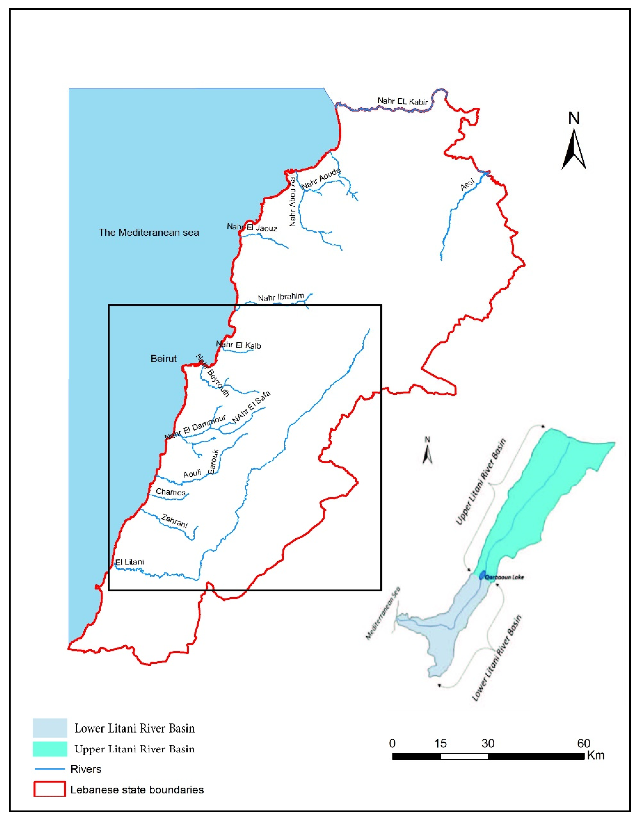
2.1. Study Sites

Lebanon is home to fifteen rivers (Figure 1), all river water has recently experienced a decrease in flow and deterioration in water quality, posing a hazard to public health and agricultural sustainability [24,25]. As a result, Lebanon serves as a model hydrologic system for linking water-related SDGs (particularly SDG 6) to features of long-term water management. The Litani River Basin is divided into two primary hydrologic units (Figure 1). These are the Upper and the Lower Litani Basins, which meet in the middle of the basin at Qaraaoun Lake to form the Litani River Basin. The river basin’s diverse land uses, particularly agricultural, leave it prone to a variety of pollution issues. As a result, agricultural pollutants are enormous, mainly from overused fertilizer [24,25,26,27,28]. The Litani River Authority (LRA) has been taking hydrological measurements on the river since the early 1960s, providing extensive input on flow regime via changing climatic circumstances and community growth.

2.2. Criteria and Specification for the Application of Biological Wastewater Treatment System

This study uses geospatial data from a Geographic information system (GIS) map to examine and analyze several parameters to find possible places for biological wastewater treatment plant application in Lebanon and the Litani River Basin. It considers the qualities of the location, meteorological data, soil qualities, topography, and other natural factors. Furthermore, land usage, soil erosion, soil depth, soil type, population number, precipitation range, and slope percentage are among the parameters utilized to choose prospective regions. Information was obtained from the SDATL (National Physical Master Plan of the Lebanese Territory) and the CNRS (National Council for Scientific Research) (see Figures S1–S3 of Supplementary Material).

2.2.1. Land Use

Biological wastewater treatment plants should be strategically placed near suitable agricultural and grassland areas. That is why the high potential of BWWT according to land use was grasslands and barelands. Woodlands were then secondarily used as acceptable for the application of BWWT plants. On the other hand, wetlands and water lands had the lowest potential for BWWT application.
  • High: barelands and grasslands
  • Acceptable: woodlands
  • Low: wetlands and water lands
  • Not applicable: urban and other lands

2.2.2. Soil Components

If percolation to groundwater is a disposal option, the site soils should be characterized [28,29] (Table 1). For a successful deployment of BWWT to preserve aquifers and avoid percolation and contamination, erosion must be minimal. The land application approach was created for places with low soil permeability and when conventional land application methods were unavailable [28,29,30]. For the application of BWWT plants, a depth of at least 90 cm is necessary, followed by an acceptable potential of 30–90 cm and a low one of less than 30 cm according to vegetation commonly utilized in BWWT plant applications (Arundo plinii, Populus alba, Pseudotsuga menziesii, Ricinus sp, Salix alba) [29,30,31,32].
Soils were classified using the USDA Natural Resources Conservation Service acceptability for wastewater irrigation [31,32,33] (Table 1). The best soil types for the application of BWWT are sandy loams [32,33,34] and the unlikely ones are clay and silt [30].

2.2.3. Population Number

BWWT sites should not be near residential areas, but even isolated terrain may not be acceptable to the general public if social, cultural, or religious attitudes reject wastewater irrigation [27,28,29]. The possible health risks associated with wastewater irrigation can make this a very sensitive topic, and public anxiety can only be alleviated if tight control measures are implemented. Therefore, location of BWWT sites was restricted to rural communities.

2.2.4. Precipitation

A range of minimum precipitation rates between 300 mm to 1400 mm, with the majority preferring high precipitation rates of more than 700 mm was established. This range is based on the above-mentioned tree and plant precipitation preferences used in the BWWT system. Because faster-growing species require more rainfall, wastewater purification has to be carried out more quickly or in larger volumes. As a result, the greater value [33,34,35] is used and the highest potential for BWWT use is between 700 and 1400 mm, whereas the lowest is between 200 and 400 mm [35,36,37]. Antecedent precipitation and soil moisture conditions can be correlated to provide an operating scheme for the system [37,38].
  • High: >1400–700
  • Acceptable: 700–400
  • Low: 400–200
  • Not applicable: less than 200 mm

2.2.5. Slope

Slope is unquestionably one of the most significant elements to consider when determining capability. Higher slopes would enhance runoff of pollutants from the site, increasing pollution of the surrounding area, hence slope is also significant when applying a BWWT plant site. Maximum grades for wastewater spray fields for row crops are often limited to 7%, which explains why the high application potential of BWWT plants is between 2 and 8% [36,37,38]. Sloping sites increase lateral subsurface drainage and reduce the likelihood of ponding and protracted soil saturation compared to level sites [36,37,38]. Water-tolerant grasses are an important component of the system, as wastewater should flow evenly down the slope to collecting ditches at the area’s bottom edge [31,32]. The site’s topography is critical, as the terrace slopes are limited to 2–8% with sufficient length to allow for enough treatment travel time. A slope of less than 2% can result in wastewater ponding, while a slope of more than 8% can result in soil erosion. Terraces are usually 30–60 m long. In general, impermeable soils are appropriate, but soils with considerable permeability should meet the slow-rate process conditions [28,29,30]. The use of BWWT plants on steep slopes is not suggested [28,29,30].
  • High: 2–8%
  • Acceptable: 0–2%/8–12%
  • Low: 12–20%
  • Not applicable: ˃20%
After selecting and specifying all the above-mentioned criteria, they must then be merged to come up with suitable areas for the implementation of BWWT. The high values and shape files of land use, soil, population number, precipitation, and slope are merged, and the high areas for the application of BWWT are identified. The same method is used to identify acceptable, low, and not applicable areas for the application of BWWT.

2.3. Modeling Theory

The fuzzy set theory is a type of soft computing reasoning that is used to handle complex problems that are difficult to address with traditional approaches [38,39]. As a result, a membership function specifies the fuzzy set, and the function represents any object on a continuous scale [38,39,40]. The membership function’s bounds are not applicable, low, acceptable, and high, signifying full non-membership to full membership, respectively. The analytical hierarchy process (AHP) is a decision-making approach that may be used to assess and support decisions with many and even competing goals [39,40,41]. A decision hierarchy [40,41] is used to break down a difficult problem into a series of smaller challenges. After the hierarchy has been formed, each element within every level is compared using a pairwise comparison matrix. Participants can compare and contrast each piece inside each level, which is linked to the levels above and below it, in order to mathematically connect the complete scheme. In terms of the overall goal, AHP is frequently used to analyze the relative suitability of a small number of alternatives. A value of “1” represents the indifference or equal importance between all the criteria and this refers to the nine-point scale used in normal analytic hierarchy investigations, which ranges from 1 (indifference or equal importance) to 9 (strong preference or absolute importance). For example, the precipitation criterion is as important as the population number criterion, the soil components criterion, the land use criterion, and the slope criterion.
Selection of appropriate fuzzy functions that yield continuous fuzzy classifications of standardized criteria is part of the process. Expert knowledge and a literature review are used to implement the fuzzy function. For criteria standardization, choosing appropriate fuzzy functions is critical. This standardization method produces a result that conveys a relative degree of belonging to a fuzzy set, ranging from not applicable to very high. For example, membership values for each criterion on fuzzy maps range from not applicable to low, acceptable, and high, with not applicable representing the least suitable locations and high being the most ideal regions for BWWT plants. The application of AHP to calculate the relative weights of the criterion is the next stage. This phase entails creating a comparison matrix and using the pairwise comparison method to determine weights. Because the BWWT is based on biological components rather than mechanical ones, all of the factors and criteria utilized in this situation use the same value.

3. Results

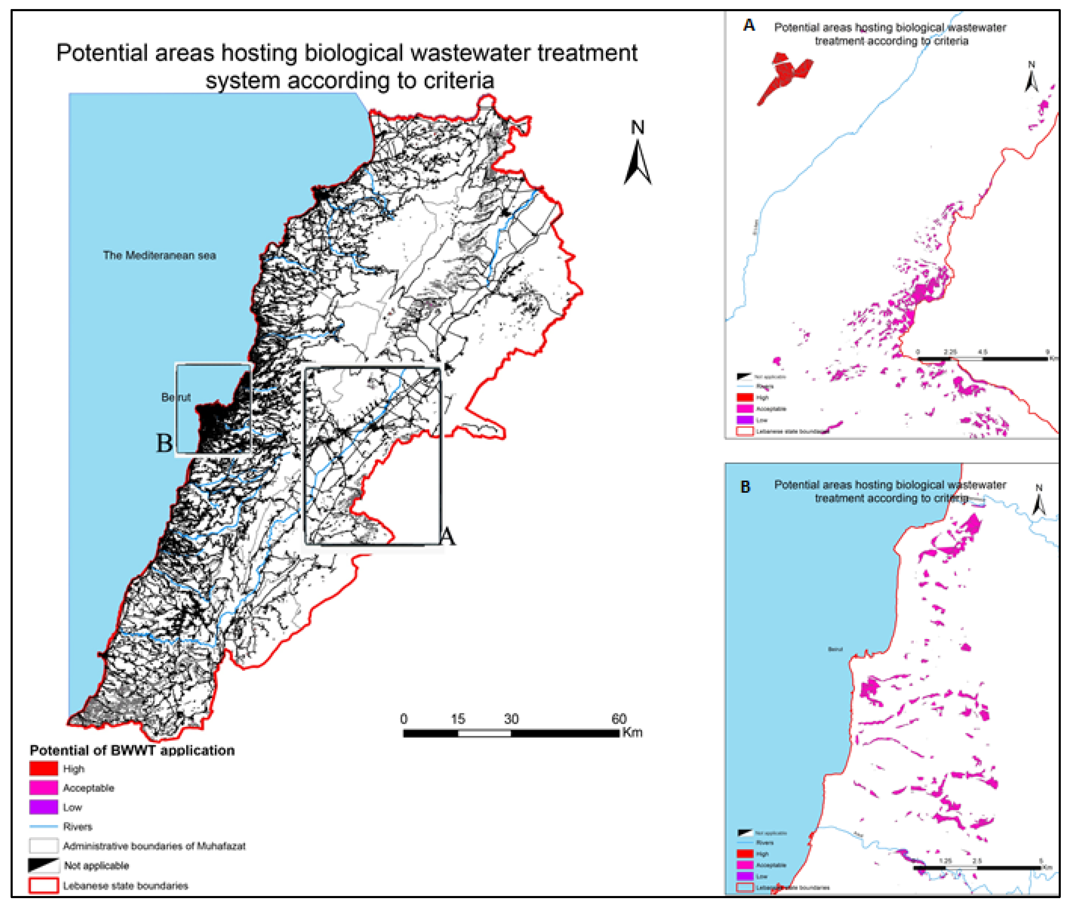
3.1. Land Suitability for Biological Wastewater Treatment in Lebanon and Litani River Basin

GIS and AHP were used to select suitable BWWT locations for the case study of Lebanon and the Litani River Basin. According to the biological application of BWWT and an exhaustive literature research, as well as accessible data, seven site selection limitations were adopted. For Lebanon (Table 2) and the Litani River Basin (Table 3), the restriction criteria employed in this study were land use, soil components (type, depth, and erosion), slope, precipitation, and low population number. The tables below show the areas of each criterion. The zero value indicates that the soil type or depth required did not exist in this area, e.g., >90 cm of soil is not present in the Litani River basin.

3.2. Cartogpahy of Land Suitability for Biological Wastewater Treatment System in Lebanon

The final suitability map is shown in Figure 2 and Figure 3. It merges the highest, acceptable, and lowest potential areas hosting BWWT according to all the above-mentioned criteria in Lebanon (Figure 2). The high values on the maps indicate more suitable areas for BWWT plants. It is important to note that the spatial distribution of the suitable areas for BWWT sites differs for each of the criteria. The total area of these potential areas is 162.94 km2, distributed as follows:
  • High (shown in red) potential suitable areas to apply the BWWT based on the best acceptable of all the above-mentioned criteria with an area of 30.40 km2; from this area, we should deduct an area of 10 km2 because the BWWT is not applicable there due to the existence of roads and buildings. Thus, the applicable area is 20.40 km2.
  • Acceptable (shown in magenta) potential suitable areas to apply the BWWT based on the intermediate acceptable of all the above-mentioned criteria with an area of 173.3 km2; from this area, we should deduct an area of 31 km2 because the BWWT is not applicable there due to the existence of roads and buildings. Thus, the applicable area is 142.3 km2.
  • Low (shown in purple) potential suitable areas to apply the BWWT based on the lower acceptable of all the above-mentioned criteria with an area of 0.24 km2 (absence of roads and buildings in this area).
  • Not applicable (shown in white) areas show the areas not recommended for the application of BWWT or that could be applied with exceptional design and operations.

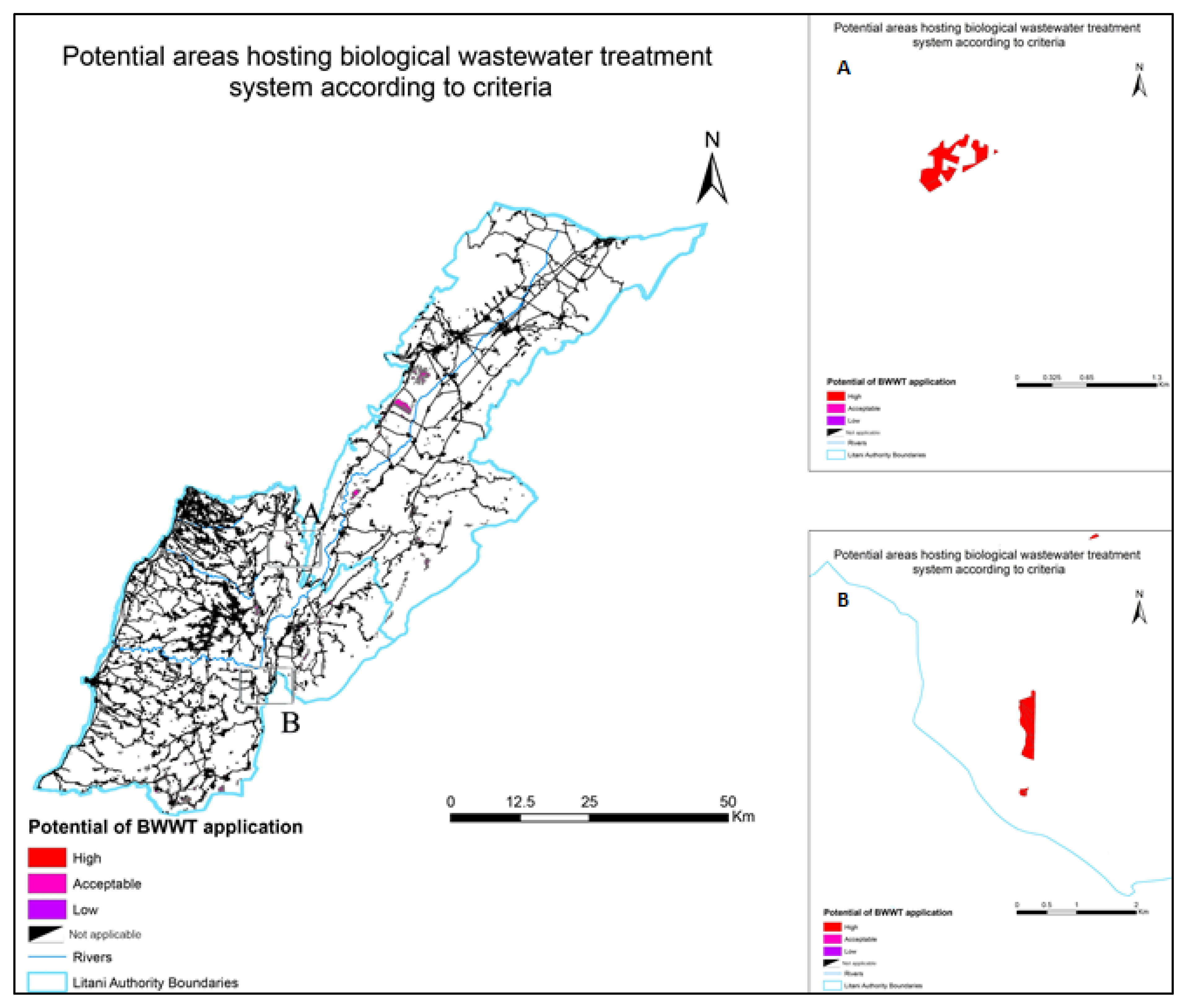
3.3. Cartogpahy of Land Suitability for Biological Wastewater Treatment System in the Litani River Basin

The final suitability map is shown in Figure 3. It merges the highest acceptable and lowest potential areas hosting BWWT according to all the above-mentioned criteria in the Litani River Basin. The high values on the maps indicate more suitable areas for BWWT plants. It is important to note that the spatial distribution of the suitable areas for BWWT sites differs for each of the criteria. The total area of these potential areas is 42.62 km2, distributed as follow:
  • High (shown in red) potential suitable areas to apply the BWWT based on the best acceptable of all the above-mentioned criteria with an area of 2.29 km2; from this area, we should deduct an area of 0.55 km2 because the BWWT is not applicable there due to the existence of roads and buildings. Thus, the applicable area is 1.74 km2.
  • Acceptable (shown in magenta) potential suitable areas to apply the BWWT based on the intermediate acceptable of all the above-mentioned criteria with an area of 44.7 km2; from this area, we should deduct an area of 3.89 km2 because the BWWT is not applicable there due to the existence of roads and buildings. Thus, the applicable area is 40.81 km2.
  • Low (shown in purple) potential suitable areas to apply the BWWT based on the lower acceptable of all the above-mentioned criteria with an area of 0.07 km2 (absence of roads and buildings in this area)
  • Not applicable (shown in white) areas show the areas not recommended for the application of BWWT or that could be applied with exceptional design and operations.

4. Discussion

Wastewater management remains one of the most difficult challenges facing Lebanese authorities [6], while it is a high priority issue to conserve the vegetation cover, particularly the riparian ecosystems of Lebanon. These ecosystems are under immense stress, not only climate-related, but also anthropogenic pollution-related, with plans to construct dams in several river valleys [8]. To mitigate the stress on these fragile formations, this study proposes the implementation of BWWT plants along the country’s river basins.
For this purpose, and to identify the most suitable locations for these plants, meticulous research on the factors determining the success of BWWT plants was employed, followed by a careful criteria gradation. Combining and filtering the resulting maps allowed the construction of a final map that differentiated areas into suitability classes: High, Acceptable, and Low, according to their potential to host BWWT. The high values on the maps are indicative of the more suitable areas for BWWT plants. It is important to note that there were important differences in the spatial distribution of the suitability classes among the different criteria. Overlapping the criteria revealed potential areas of around 162.94 km2 all over Lebanon, and 42.62 km2 in the Litani basin areas alone. This explains the importance of such a project covering around 1.55% of the country’s territory, with a span of more than 30 regions and the total number of beneficiaries reaching between 60,000 and 180,000 inhabitants, i.e., between 1.5% and 3.75% of the total population. The importance of the implementation of BWWT goes even further than ecology conservation and land reclamation reaching daily lives of farmers with the resulting purified water that is in great demand for irrigation.
This study also shows the importance of large scale when studying land use and land suitability. Urban lands are excluded from hosting BWWT where the population number is high [20]. Vegetation commonly employed in the application of BWWT plants requires specific soil types for root development. These faster-growing species require more rainfall and wastewater purification needs to be carried out more quickly or in larger volumes where the precipitation rate is higher than 700 mm [19]. Consequently, these species perform better in areas with a high percentage of stoniness and steep slopes, making them unsuitable for BWWT [20,21]. Accordingly, the evaluation of the degree of conformance of the zoning map’s proposed land use designations for specific parcels, to the land suitability classification obtained in this study, is a tool for determining the stress applied to each parcel of land and predicting the possible BWWT for each type of land.
Slope, land use, soil components (type, depth, and erosion), population number, and precipitation are all factors considered by the model [22,23]. It has an overall accuracy of 89%, indicating that the parameters and weights had been carefully chosen, with slope playing the most important role in evaluating land suitability. This could be due to the study region’s landscape, which is characterized by the occurrence of sloping and steep lands with sloping in the Litani river basin [21]. Although the findings were thought to be useful in assessing water management since they provide an overview of the stress placed on the land, they were not deemed to be particularly useful in assessing water management. To increase the efficient use of lands for BWWT, this design should be directed according to the land suitability classes. The findings suggest that land usage is not always the best option in some situations. The land suitability map for BWWT could provide a general overview of the area’s potential uses. The assessment of land suitability is not adequate to plan for restoration activities and advise on land use; this study should be followed by further specific studies to suggest appropriate land use for each parcel in the region. The produced map provides more information about the land suitability for BWWT in the research area, allowing public management organizations to use it as a planning tool to aid in more effective land planning. Knowing that climate change has an impact on all these factors, although at varying rates, and climate change is projected to cause greater changes in the hydrological variables in the Lebanese part of the Litani river basin, one of the studies that we suggest is how climate change can affect the location of the suitability areas.
The proposed solutions go beyond simple water management techniques and should be part of a national riversides restoration policy. Such plants would enhance fluvial systems, control flood risks, and increase towns’ resilience while improving the towns’ livelihoods. The resulted land suitability map of Lebanon and that of the Litani River Basin can be used as a planning tool by authorities for their projects aimed at improving land use efficiency and mitigating climate change effects. Biological wastewater treatment is an important component of long-term water management and directly supports the goals of national and regional water policies.
The kind of solution suggested which could be part of a riverside’s restoration policy is not a simple water management technique and its results are usually limited. It would be desirable to enhance fluvial systems, control flood risks, and increase towns’ resilience while improving the towns themselves. The land suitability map of Lebanon and of the Litani River Basin can be used as a planning tool by governors and planners to improve land use efficiency and identify potential sites for a Biological Wastewater Treatment system in the Litani River Basin and maybe in other Lebanese watersheds. Biological wastewater treatment is an important component of long-term water management and directly supports the goals of national and regional water policies. However, the wastewater sector is being affected by climate change in various ways. The final suitability map merges the highest, acceptable, and lowest potential areas hosting BWWT according to the here mentioned criteria in Lebanon: land use; soil components (soil erosion, soil depth, soil type); population number; precipitation; slope. The high values on the maps indicate the more suitable areas for BWWT plants. It is important to note that the spatial distribution of the suitable areas for BWWT sites differs for each of the criterion. The total area of these potential areas is 162.94 km2 all over Lebanon and 42.62 km2 in the Litani basin areas after overlapping all criteria together. The final aggregation of the seven intermediate suitability maps shows the importance of each criterion for BWWT use in Lebanon and the Litani River Basin, respectively.

5. Conclusions

Biological wastewater treatment (BWWT) has been demonstrated to be a suitable treatment technology to degrade organic pollutants by utilizing natural processes In the Lebanon context, optimization of plant design and location of BWWT can guarantee high water effluent quality contributing to river ecosystems’ conservation. In this research, geographic layers and fuzzy theory and the analytic hierarchy process (AHP) were adopted to identify potential areas for BWWT for Lebanon and the Litani River Basin. The results indicated that the spatial distribution of the suitable areas for BWWT sites differs for each of the criteria, and Lebanon presents a high relative area to implement these water treatments. The proposed approach, coupling the GIS mapping tool with the existing data layers and machine learning, has shown to be very useful for ranking zones with potentially elevated suitability for BWWT sites which may be applied to other countries in the Middle East countries, and may help government agencies identify priority risk zones. Additionally, this methodology can contribute to riparian forest ecosystem restoration and mitigate the impact of climate change. It is necessary to raise policymakers’ knowledge of the potential BWWT-hosting sites and provide land use planners with information on the land’s optimal usage for it to be effective. If early actions are undertaken, excellent communication between experts and decision makers is likely to enhance sustainable land use and aid in environmental conservation.

Supplementary Materials

The following supporting information can be downloaded at: https://www.mdpi.com/article/10.3390/f13020139/s1, Figure S1. Maps of Lebanon showing “depth, erosion, land use, slope, precipitation, and soil type” criteria. Figure S2. Mapping of the Litani Basin showing “depth, erosion, land use, slope, precipitation, and soil type” criteria. Figure S3. Map of Lebanon showing suitable areas criteria.

Author Contributions

G.K. and G.P.-R. planned and designed the research. G.K. and S.K. conducted fieldwork. G.K., S.K. and G.P.-R. contributed to data elaboration and analysis. G.P.-R. supervised the geomatic analysis. G.K. and G.P.-R. wrote the manuscript, with contributions by S.K. All authors have read and agreed to the published version of the manuscript.

Funding

This research was funded by the Lebanese University through the doctoral fellowship programme (grant number 2017/GK/26090/LU) under the PhD research cotutele agreement between the University of Córdoba and the Lebanese University.

Institutional Review Board Statement

Not applicable.

Informed Consent Statement

Not applicable.

Data Availability Statement

Not applicable.

Conflicts of Interest

The authors declare no conflict of interest.

References

  1. Jaber, B. La Problématique de L’eau au Liban. Rapport; Ministère des Ressources Hydrauliques et Electriques: Beirut, Liban, 1997. [Google Scholar]
  2. EMWATER. Prospects of Efficient Wastewater Management and Water Reuse in Lebanon; EMWATER: Beirut, Lebanon, 2004; p. 77. [Google Scholar]
  3. Shaban, A. Impact of climate change on water resources of Lebanon: Indications of hydrological droughts. In Climatic Changes and Water Resources in the Middle East and NORTH AFRICA; Zereini, F., Hötzl, H., Eds.; Environmental Science and Engineering (Environmental Science): Beirut, Lebanon, 2008; pp. 125–143. [Google Scholar]
  4. Allen, L.; Palaniappan, P. Overview of Greywater Reuse: The Potential of Greywater Reuse to Aid Sustainable Water Management; Pacific Institute: Oakland, CA, USA, 2010; p. 41. [Google Scholar]
  5. Qadir, M.; Wichelns, L.; McCornick, P.; Drechsel, A.; Minhas, P. The Challenges of Wastewater Irrigation in Developing Countries; Agricultural Water Management: Lincoln, NE, USA, 2010. [Google Scholar]
  6. Geara, D.; Moilleron, R.; El Samarani, A.; Lorgeoux, C. Considerations of Wastewater Reuse System for Irrigation; FAO/RNEA: Beirut, Lebanon, 1992; pp. 139–152. [Google Scholar]
  7. EC. Support to DG Environment for the Development of the Mediterranean De-Pollution Initiative: “Horizon 2020”; EC: Athens, Greece, 2006; p. 205. [Google Scholar]
  8. MoE. Lebanon State of the Environment and Future Outlook; SOER Report; UNIEF: Beirut, Lebanon, 2020. [Google Scholar]
  9. MoE. Strengthening the Environmental Legislation Development and Application Systems in Lebano; SELADAS: Beirut, Lebanon, 2004. [Google Scholar]
  10. Qadir, M.; Wichelns, D. Agricultural Use of Marginal-Quality Water-Opportunities and Challenges. Molden, D., Ed.; IWMI & Earthscan: London, UK, 2007. [Google Scholar]
  11. IWMI. Recycling Realities: Managing Health Risks to Make Wastewater an Asset; Sharni Jayawardena: Colombo, Sri Lanka, 2006. [Google Scholar]
  12. WHO. Guidelines for the Safe Use of Wastewater; WHO: Geneva, Switzerland, 2006. [Google Scholar]
  13. World Bank. Irrigation, Rehabilitation and Modernization Project: Staff Appraisal Report; World Bank: Washington, DC, USA, 1994. [Google Scholar]
  14. Khatib and Alami Company. Report on the Derived Land Use Map of Lebanon; FAO: Beirut, Lebanon, 1997. [Google Scholar]
  15. CDR/EC (Council for Development and Reconstruction, European Commission). Studies and Guidelines for Project Selection and Prioritization; IPP: Beirut, Lebanon, 2004.
  16. CDR. Schéma D’aménagement du Territoire Libanais; Conseil du Développement et de la Reconstruction: Beirut, Liban, 2002.
  17. Karam, F.; Mouneimne, A.; El-Ali, F.; Mordovanaki, G.; Rouphael, Y. Wastewater management and reuse in Lebanon. J. Appl. Sci. Res. 2013, 9, 2868–2879. [Google Scholar]
  18. Korfali, S.I. Deterioration of coastal water aquifers causes and impacts. Eur. Water 2010, 29, 3–10. [Google Scholar]
  19. Roy, M.; Saha, R. Dyes and their removal technologies from wastewater: A critical review. In Intelligent Environmental Data Monitoring for Pollution Management; Academic Press: Rajasthan, India, 2021. [Google Scholar]
  20. Brix, H. Plants used in constructed wetlands and their functions. In 1 st International Seminar on the Use of Aquatic Macrophytes for Wastewater Treatment in Constructed Wetlands; Ministerio das Cidades, Ordenamento do Territ¢rio E Ambiente: Copenhagen, Denmark, 2003. [Google Scholar]
  21. Mandi, L.; Houhoum, S.; Asmama, J.; Schwartzbrod, J. Wastewater treatment by reed beds: An experimental approach. Water Res. 1996, 30, 2009–2016. [Google Scholar] [CrossRef]
  22. Culp, J.; Prowseeric, T.; Luiker, A. Mackenzie River Basin. In Rivers of North America; Elsevier/Academic Press: Amesterdam, The Netherlands, 2005; pp. 804–850. [Google Scholar]
  23. Capodaglio, A.; Olsson, G. Energy Issues in Sustainable Urban Wastewater Management: Use, Demand Reduction and Recovery in the Urban Water Cycle. Sustainability 2020, 12, 266. [Google Scholar] [CrossRef] [Green Version]
  24. Kontos, T.D.; Komilis, D.P.; Halvadakis, C.P. Siting MSW landfills on Lesvos Island with a GIS based methodology. Waste Manag. Res. 2003, 21, 262–277. [Google Scholar] [CrossRef] [PubMed]
  25. Shaban, A. Analyzing climatic and hydrologic trends in Lebanon. J. Environ. Sci. Eng. 2011, 5, 483–492. [Google Scholar]
  26. Jaber, B. Water Availability in Lebanon. In Workshop on Water Affairs in Lebanon and Peace-Process and Project Series of Lebanon Life Studies-5; Elsevier: Beirut, Lebanon, 1993; pp. 53–66. [Google Scholar]
  27. Fawaz, M. Water Resources in Lebanon. In Proceedings of the National Workshop of the Status of Water in Lebanon; Taylor & Francis: Beirut, Lebanon, 1992; pp. 17–29. [Google Scholar]
  28. Hajjar, Z. Water Needs in Lebanon: Potable, Agricultural and Industrial. In Proceedings of the Workshop on Water Affairs in Lebanon and Peace-Process in Project Series of Lebanon Life Studies-5, Beirut, Lebanon; 1993; pp. 67–68. [Google Scholar]
  29. EPA. Principles of Design and Operations principles of Design and Operations of Wastewater Treatment Pond Systems Wastewater Treatment Pond Systems for Plant Operators, Engineers, and Managers; Land Remediation and Pollution Control Division National Risk Management Research Laboratory Office of Research and Development: Cincinnati, OH, USA, 2011.
  30. Heldman, D.; Moraru, C. Wastewater Treatment Process; Agricultural Food and Biological Engineering: Taylor & Francis: New York, NY, USA, 2011. [Google Scholar]
  31. Farjon, A. Pseudotsuga Menziesii. In IUCN Red List of Threatened Species; London, UK, 2013; Available online: https://0-doi-org.brum.beds.ac.uk/10.2305/IUCN.UK.2013-1.RLTS.T34025A2840746.en (accessed on 10 November 2021).
  32. Pescod, M. Wastewater Treatment and Use in Agriculture; FAO: Rome, Italy, 1992. [Google Scholar]
  33. Lovell, B. Soil Survey of Malheur County, Oregon Northeastern Part; United States Department of Agriculture, Soil Conservation Service, in Cooperation with the Oregon Agricultural Experiment Station: Ontario, OR, USA, 2002. [Google Scholar]
  34. Hybrid Poplar (Populus hybrids). Available online: https://www.ag.ndsu.edu/trees/handbook/th-3-133.pdf (accessed on 22 May 2021).
  35. Conifers Nutrition. Available online: https://www.canr.msu.edu/hrt/uploads/535/78626/conifernutrition.pdf (accessed on 22 May 2021).
  36. Des Saules Pour Recycler Les Eaux Usées. Available online: https://ici.radio-canada.ca/nouvelle/1062499/eaux-usees-traitement-arbres-saules-bio-recyclage-energie-recuperation-environnement-traitement-municipalite-agriculture (accessed on 22 May 2021).
  37. Lavender, D.; Miller, R.; Grier, C. Nutrient cycling in the douglas-fir type. In Silvicultural Implications; Washington, DC, USA, 1975; Available online: https://www.fs.fed.us/pnw/olympia/silv/publications/opt/156_MillerEtal1976.pdf (accessed on 10 November 2021).
  38. Guidelines for Slow-Rate Land Treatment of Wastewater via Spray Irrigation; State of Georgia Department of Natural Resources Environmental Protection Division Watershed Protection: Atlanta, GA, USA, 2010.
  39. Huanga, Y.; Lanb, Y.; Thomsona, S.J.; Fangc, A.; Hoffmannb, W.C.; Laceyd, R.E. Development of soft computing and applications in agricultural and biological engineering. Comput. Electron. Agric. 2010, 71, 107–127. [Google Scholar] [CrossRef] [Green Version]
  40. Eastman, J.R.; Kyem, P.A.K.; Toledano, J. A Procedure for Multiobjective Decision Making in GIS under Conditions of Conflicting Objectives; EGIS’93 (Utrecht: EGIS Foundation): Clark Universitv: Worceste, MA, USA, 1993; pp. 438–448. [Google Scholar]
  41. Saaty, T.L. Decision making with the analytic hierarchy process. Int. J. Serv. Sci. 2008, 1, 83–98. [Google Scholar] [CrossRef] [Green Version]
Figure 1. Litani River Basin—Lebanon.
Forests 13 00139 g001
Figure 2. Potential areas hosting BWWT system in Lebanon based on fuzzy function of standardized spatial criteria. (A) Detail locations at eastern part of Lebanon, (B) Detail locations at Beirut region.
Forests 13 00139 g002
Figure 3. Potential areas hosting BWWT system in the Litani River Basin based on fuzzy function of standardized spatial criteria. (A,B) Detailed locations.
Forests 13 00139 g003
Table 1. Soil erosion, depth, and type according to their suitability in BWWT.
Soil Soil Erosion Soil Depth Soil Type
High very low and low ˃90 cm ˃64% sand
Acceptable medium 30–90 cm ˃50% silt
Low highless than 30 cm˃40% clay
Not applicable Very high less than 30 cm˂40% clay
Table 2. Fuzzy set memberships, membership functions, and areas used for the BWWT system in Lebanon.
Criteria Area
Land use High 3510 km2
Acceptable 2385.2 km2
Low 32 km2
Not applicable 26.8 km2
Soil typeHigh 2568 km2
Acceptable 1908 km2
Low 4177 km2
Not applicable 3 km2
Soil depth High 0
Acceptable 7635 km2
Low 2073 km2
Not applicable 0
Soil erosion High 945 km2
Acceptable 4862 km2
Low 1848 km2
Not applicable 22 km2
SlopeHigh1359 km2
Acceptable 3559 km2
Low 834 km2
Not applicable 34 km2
Precipitation High 1062 km2
Acceptable 2405 km2
Low 857 km2
Not applicable 105 km2
Low population number criteriaApplicable 9936.68 km2
Not applicable 101.72 km2
Table 3. Fuzzy set memberships, membership functions and areas used for BWWT plants in the Litani River Basin.
Criteria Area
Land use High 2448 km2
Acceptable 734.5 km2
Low 4.4 km2
Not applicable 45 km2
Soil typeHigh 436.4 km2
Acceptable 0.26 km2
Low 0
Not applicable 0
Soil depth High 0
Acceptable 710 km2
Low 2073 km2
Not applicable 0
Soil erosion High 648 km2
Acceptable 4652 km2
Low 1870 km2
Not applicable 2.9 km2
Slope High969 km2
Acceptable 2754 km2
Low 520 km2
Not applicable 4.7 km2
Precipitation High 5905 km2
Acceptable 1589 km2
Low 439 km2
Not applicable 55 km2
Low population number criteriaApplicable 638.2 km2
Not applicable 31.8 km2
Publisher’s Note: MDPI stays neutral with regard to jurisdictional claims in published maps and institutional affiliations.

