Article

Trends in Forest Fire Occurrence in the Ilmensky Nature Reserve, Southern Urals, Russia, between 1948 and 2014

by
Denis Veselkin
1,
Nadezhda Kuyantseva
2,3,
Liliya Pustovalova
1,* and
Aleksandr Mumber
2
1
Institute of Plant and Animal Ecology UB RAS, Yekaterinburg 620144, Russia
2
Ilmensky State Reserve, Federal State Budgetary Institution of Science South Urals Research Center of Mineralogy and Geo-Ecology UB RAS, Miass 456317, Russia
3
Department of Technical Mechanics, Natural Sciences of South Ural State University, Chelyabinsk 454080, Russia
*
Author to whom correspondence should be addressed.
Submission received: 31 December 2021 / Revised: 22 March 2022 / Accepted: 25 March 2022 / Published: 29 March 2022

Abstract

:
We analyzed the spatial distribution and temporal dynamics of 1083 forest fires within the Ilmensky Reserve (Southern Urals, Russia) over 1948–2014. We observed a significant increase in the number of forest fires over the studied period, with the locations of the most frequently burned sections of the reserve changing over time. The average number of fires over the whole period increased by a factor of 1.9; there were 0.41 fires per compartment per 10 years in 1948–1970, there were 0.58 fires per compartment per 10 years in 1971–1990, and there were 0.77 fires per compartment per 10 years in 1991–2014. In parallel, the spatial pattern of ignitions became more aggregated. The fire frequency increased across the reserve, with the most pronounced change being observed along the reserve borders. Human-related fires dominate the modern fire activity within the Ilmensky Reserve, which is modulated by the local conditions.

1. Introduction

Forest fires are among the key factors in the distribution and dynamics of the vegetation cover of the boreal zone [1,2,3]. The number of forest fires and the burned forest area show contrasting temporal trends over the boreal zone of Eurasia [4,5] and North America [6,7,8]. Studies reporting an increasing trend in fire activity have associated these dynamics to human ignitions [9,10,11,12,13] and climate changes [14,15,16,17,18,19,20]. The length of the available records appear to be of critical importance in quantifying the temporal dynamics of fire activity and their underlying causes. Analyzing sufficiently long data series is necessary to assess reliably the dynamics of forest fires and their causes. However longer records such as paleochronological reconstructions [21] suffer from the decline in temporal and spatial resolution, while those resolved at finer scales, such as remote sensing data [22,23,24,25], are short.
Variability of the spatial pattern of forest fires at the mesoscale (10–100 km2) is poorly studied in the Eurasian southern boreal forest. Most of the studies in this region have used Earth remote sensing data to describe the spatial variability of fires at a scale of thousands of kilometres [13,20,25]. Existing analyses of the fire numbers and areas in different periods [26,27] lack a spatial component, although a number of studies have provided detailed fire maps [28,29,30]. Recently, detailed assessments of the canopy fuel and forest fire risk for different districts have been obtained using LiDAR techniques [31,32,33].
Ilmensky State Reserve (ISR) in the Southern Urals features one of the longest records of the number of fires in Russia. This observational record covers an area of 30 000 hectares and stretches over 1948 to 2014. Since 1948, the annual number of fires recorded on its territory has been consistently increasing, with the dynamics being ascribed to the lengthening of the fire season [34]. The weather conditions in the months and seasons of the year explain only a small fraction (18–23%) in the interannual variability in the fire number [34]. This result called for a more in-depth analysis of fire activity and a particular focus on humans as the source of fire ignitions. In this study, we hypothesized that increasing anthropogenic pressure drove the observed dynamics. We studied the distribution of fire within the territory of the reserve and tested for the differences in fire frequencies between the border and the core areas of the reserve. We assumed that the core areas, being better protected and less visited by the local population, have a lower increase in the fire occurrence when compared to the areas at the borders of the reserve.

2. Materials and Methods

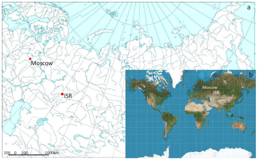
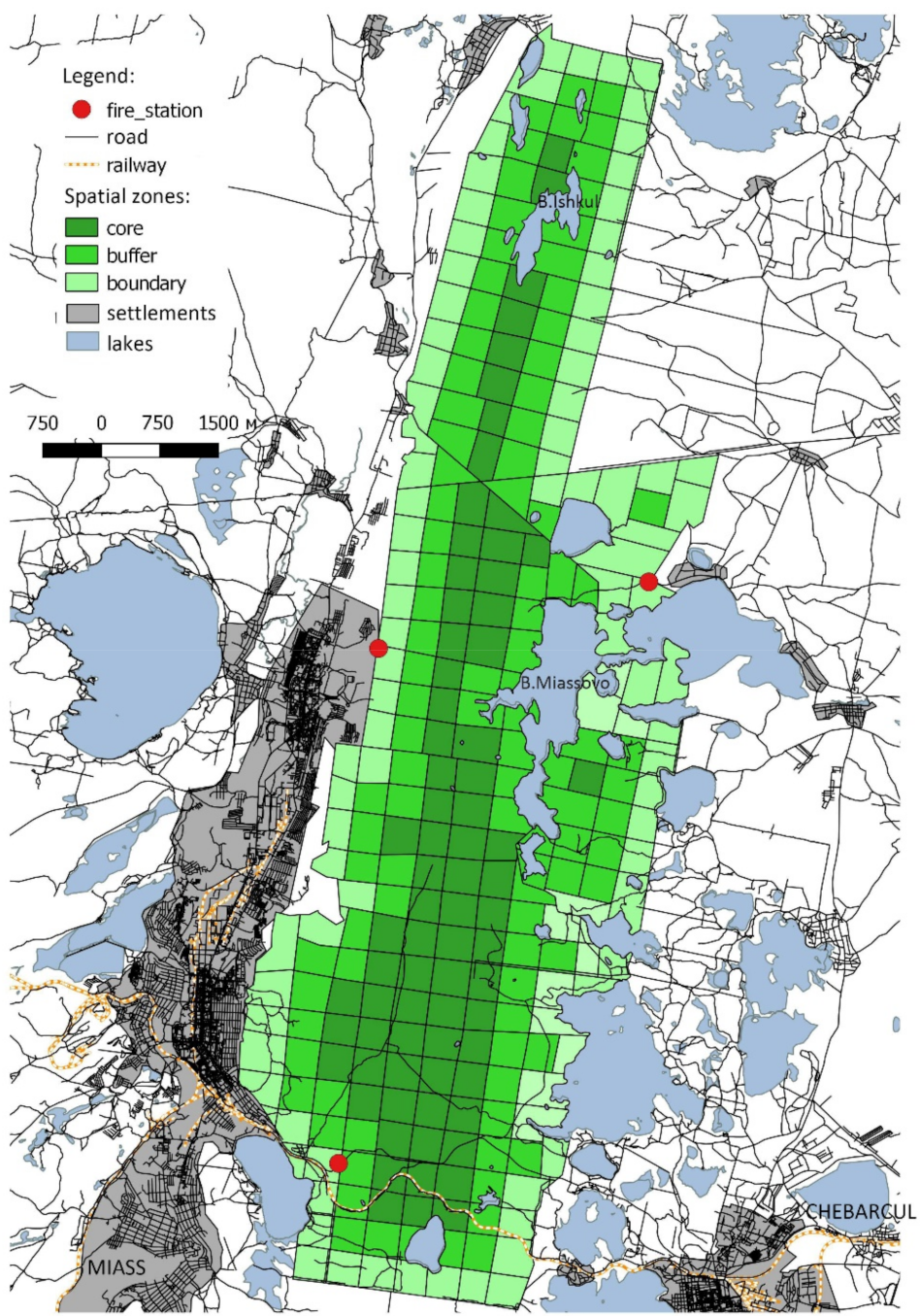
2.1. The Study Region

The ISR, established in 1920, is among the oldest reserves of the Russian Federation. The area of the ISR is 30,380 hectares. The reserve is located on the Southern Urals in the Chelyabinsk Region (Figure 1). The climate is moderately continental, with a mean temperature of +1.9 °C. The mean temperature in January is −14.5 °C and the mean temperature in July is +17.9°. The annual precipitation amount is 454 mm.
The ISR is located on the eastern slopes of the Southern Urals. The Ilmensky ridge stretches along the western part of the reserve. Its maximal elevation is 747 m above sea level. The mountains have smooth peaks and gentle slopes. The eastern part of the reserve is occupied by a piedmont depression zone with numerous lake basins.
The prevailing zonal types of soils are gray forest soil and dark gray forest soil (Luvic Phaeozems and Chernic Phaeozems according WRB-2014).

2.2. The ISR Vegetation Cover

The ISR belongs to the natural ecotone between southern taiga and forest steppes [35]. Forest communities are predominant. Pinetum myrtillosum forests dominate at the slopes of the Ilmensky ridge and at the piedmonts. On the peaks and southern slopes of the ridge, Siberian larch (Larix sibirica Lebed.) forests are combined with thickets of the steppe shrubs, steppe meadows, and steppes. Xeric forests, with Scots pine (Pinus sylvestris L.) and lichen (Cladonia spp.) on the forest floor, can be found predominantly on the rock outcrops. In the foothills there are Scots pine forests with herbaceous cover: Rubus saxatilis L., Fragaria vesca L., Calamagrostis arundinacea (L.) Roth. Secondary birch forests (Betula pendula Roth.) are widespread.
The forested area is 25,200 hectares or 83% of the ISR territory. From 1985 to 1999, the forest area increased by 400 hectares (1.6%) due to the natural afforestation of mountainous steppe communities and forest areas on the tops of the hills. The forest distribution by vegetation types is as follows: coniferous (Pinus sylvestris, Larix sibirica)—13,700 hectares; deciduous (Betula spp., Populus tremula L., Alnus incana (L.) Moench, Al. glutinosa (L.) Gaertn., Tilia cordata Mill.)—11,300 hectares. The Bonitet distribution is as follows: high-performance forests—12,500 hectares; moderately productive forests—12,100 hectares. The distribution of forest stands by age classes is uneven; 85% of the ISR forests comprise middle-aged and mature trees. The average tree age of the main generation in coniferous (Pinus sylvestris) forests is 80–180 years; in deciduous (Betula spp., Populus tremula) forests, it is 50–90 years.
The reserve is located in the industrialized and densely populated area of the Southern Urals. Along its south-western boundary, stretching over 24 km, the ISR neighbours the city of Miass, with a population of 181,000 people (1959—99,000; 1973—139,000; 1992—170,000 people). The Trans-Siberian Railway and the Miass-Chelyabinsk public road pass through the ISR territory in W–E direction. On its south-eastern side, the ISR borders with the Kisegach Resort, which hosts 52 cottages. Maloe Miassovo Lake makes the eastern boundary of the ISR. The Chebarkul Fish Factory (Chebarkul, Russia) operating at this lake regulates the lake water level to support fishery. No large-scale agricultural production occurs around the ISR.

2.3. Nature Protection Inside the ISR

According to the International Union for the Conservation of Nature (IUCN) classification, the ISR protection category is IA, Strict Nature Reserve. All activities disrupting the natural development of natural processes, threatening the state of natural complexes and objects, and unrelated to the fulfilment of tasks assigned to the reserve, such as environmental protection and research, are directly prohibited on the ISR territory. Particularly, wood logging, hunting, staying within the reserve territory with fishing and hunting gear, and excursions and tourism are prohibited. The buffer zone of the reserve is a 250 m wide forest area of the Miass forestry along its western boundary. There are 23 ranger districts organized for the reserve protection with the average district area being 1300 hectares.
The ISR fire protection system includes, among others, educational activities such as lectures, meetings with the local population, and posting warning boards, as well as fire preventive activities such as organizing fire breaks, clearing debris, forest litter removal, and soil ploughing. The fire preventive activities are carried out on the borders of the ISR and along the coastline of border lakes.

2.4. Fire Data

The fires are an important factor of the ISR forest dynamics. On average, 15–17 forest fires occur annually within the reserve territory [34]. The fire activity data from the ISR forests for 10-year periods are available from 1890 and monthly summaries are available since 1948. They are systematized for the ISR based on the “Fire Records’ Book”. Entries in the book are made based on direct field observations of researchers and employees of the reserve. The book contains data on fire size, type of fire, and its duration. The data used in this study were the number of fires per compartment per year, available in the monthly-resolved dataset. The dataset includes the observation results for each of the 273 compartments over 67 years, from 1948 to 2014. We divided the observation period into three periods, with their length being approximately 20 years: 1948–1970, 1971–1990, and 1991–2014. The first period was based on the fact that in 1966, the schedule of work of the population changed: the working week had become 5 days with two days off. The second period ends in 1990, because in 1991, the USSR collapsed. This was accompanied by economic changes, new laws, and regulations, including those regarding the activities of protected areas. For each period, we calculated the average number of fires per compartment over a 10 year period.

2.5. Spatial and Statistical Analysis

For the purpose of spatial analysis, all compartments (n = 273) were combined into three spatial zones: (1) the compartments near the reserve boundaries were designated as “boundary”, n = 99; (2) the compartments of the second layer, bordering with the compartments adjacent to the boundaries, and the compartments near the lake shores were designated as “buffer”, n = 99; (3) the internal compartments were designated as “core”, n = 75 (Figure 2).
Analysis of the spatial patterns of forest fires and data visualization were performed using the ArcMap (ESRI Inc., Redlands, CA, USA) and QGIS (https://qgis.org/en/site/, accessed on 31 November 2021) geographic information systems. Information from open sources was also used. OpenStreetMap geoinformation layers in the form of shape files containing data on the location of hydrological network objects and settlements were obtained from the gis-lab.info website.
We used non-parametric χ2 tests to compare the frequency distributions of the number of forest fires in the compartments and spatial zones. We used the Kruskal–Wallis H test for comparing non-normal distribution quantitative data. The χ2 and H calculations were performed using the STATISTICA 8.0 software (StatSoft Inc., Tulsa, OK, USA, 1984–2007). When calculating the χ2 values, marginal frequencies below five were completed to five. The Poisson distribution used to test the assumptions whether the distribution of fires were random or not. The negative binomial distribution was used to test the assumptions whether the distribution of fires are contagious or not. The frequencies of the inverse binomial distribution were calculated in accordance with the manual [36]. We compared the spatial distribution of fires over periods via correlations between the number of fires at each compartment in the first (1948–1970), second (1971–1990), and third (1991–2014) periods. In this case, the average number of fires per 10 years, per compartment in each of the three time periods, was used as the initial data. We calculated the spatial correlation using ArcMap Spatial Analyst extension (ESRI Inc., Redlands, CA, USA).

3. Results

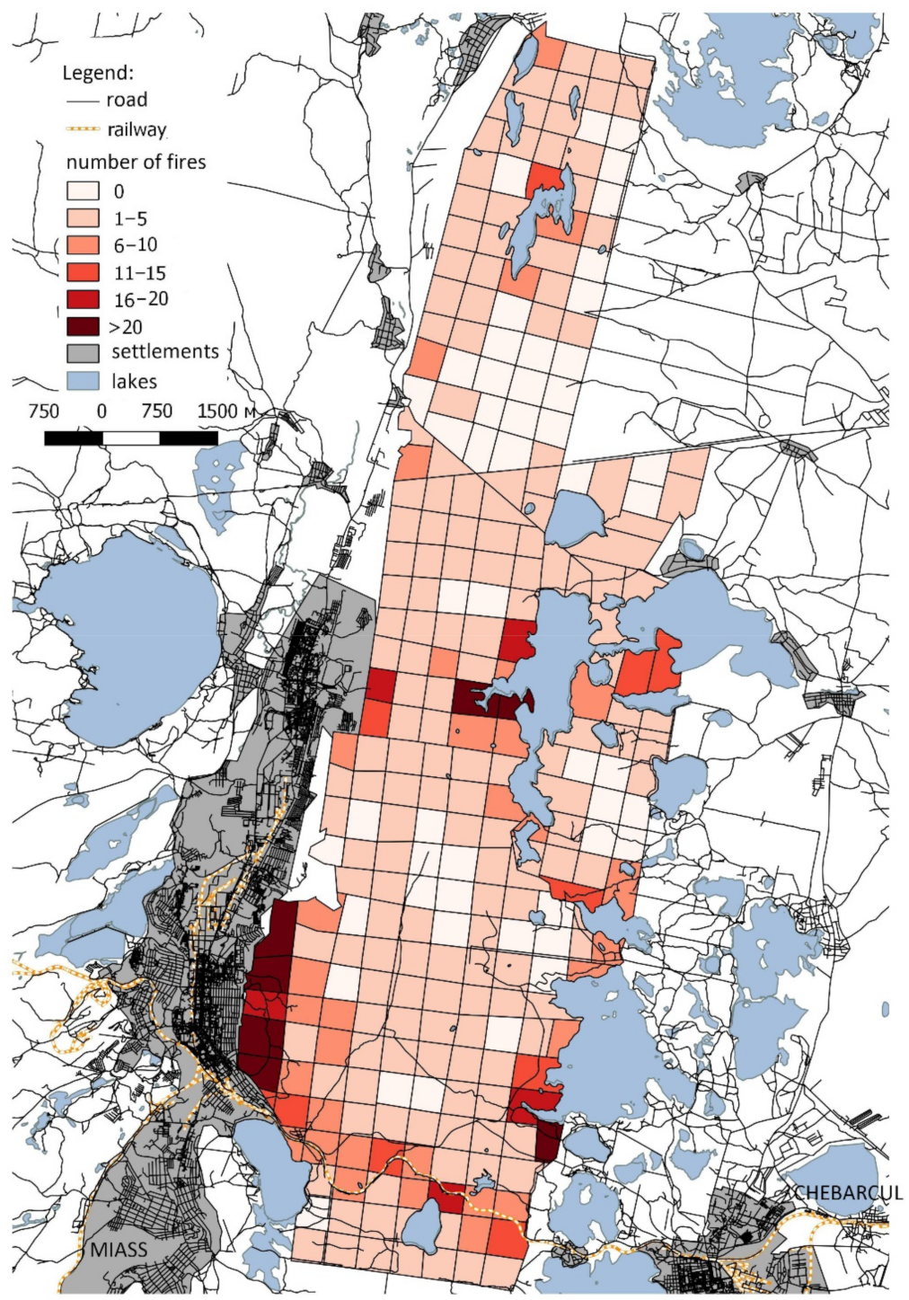
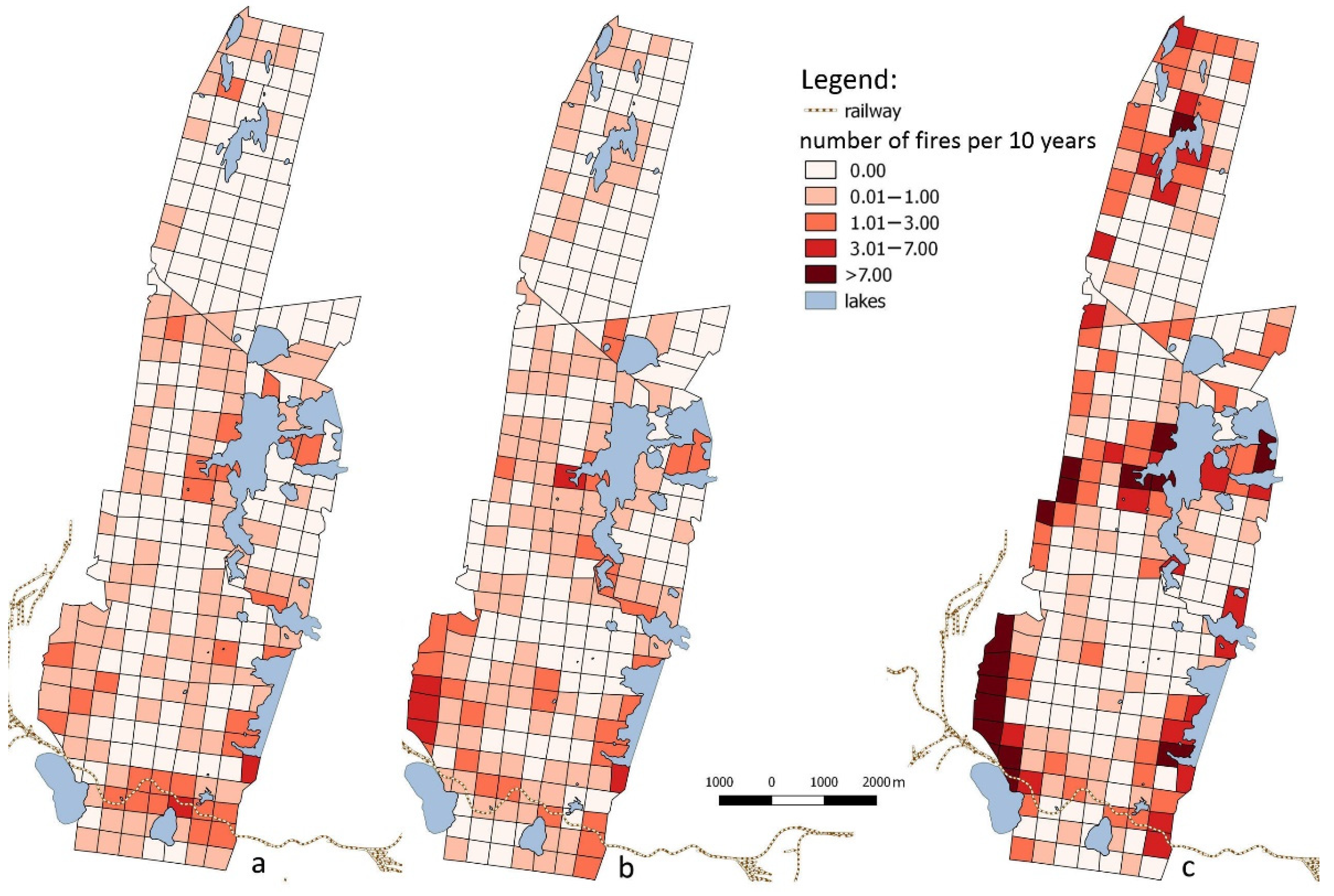
3.1. Spatial Pattern of Fires during 1948–2014

Over 67 years, 1083 forest fires were registered in 221 out of 273 ISR compartments. The minimum number of fires in one compartment was zero, the maximum was fifty-eight, and the median was two. The average number of fires per compartment for whole observation period was 3.97, with a variance of 38.19.
The distribution of fires within the ISR territory was aggregated. The compartments that burned the most often were in the ISR southern part and at the reserve boundaries (Figure 3).
A non-random occurrence of fires was confirmed by analyzing the frequency distribution of the number of fires within forest compartments (Figure 3 and Figure 4). The empirical distribution of the number of fires in the compartments differed significantly from the Poisson distribution: χ2 = 43.80, dF = 2, p < 0.0001. However, the empirical distribution did not differ significantly from the inverse binomial distribution used to describe contagiously distributed objects: χ2 = 5.58, dF = 4, p = 0.2324. We suggest the presence of compartments and groups of closely located compartments that burned significantly more frequently than the whole reserve territory on average.

3.2. Spatial Fire Distribution in 1948–1970, 1971–1990, and 1991–2014

Fire occurrence in IST increased over time (Table 1). The total and average numbers of fires per compartment in 1991–2014 were almost twice the values for 1948–1970. In all periods, the fire distribution within the territory was uneven (Figure 5). The distribution of the numbers of fires in compartments was consistently significantly different from the Poisson distribution and insignificantly from the inverse binomial distribution. Consequently, ISR compartments with high fire occurrence were clustered for all periods. The frequently burned compartments were confined to the ISR southern part, as well as to the lake shores and reserve boundaries.
From 1948–1970 to 1991–2014, the heterogeneity of the forest fire distribution within the ISR territory increased. This was evidenced by (1) a more than three-fold increase in the dispersion/mean ratio for the number of fires per compartment; (2) a larger departure of the observed distribution from the one expected under the Poisson process (Figure 5).
The fire occurrence within the ISR territory changed over time. Formally, this can be illustrated by analyzing the similarity of spatial distributions. The spatial correlation coefficient between the fire distributions in the first (1948–1970) and second (1971–1990) periods was rspatial = 0.42, while between the fire distributions in the second (1971–1990) and third (1991–2014) periods, rspatial = 0.40. However, between the fire distributions in the first (1948–1970) and third (1991–2014) periods, the similarity was noticeably lower: rspatial = 0.25. We observed the same pattern in the rank correlation between the number of fires in 273 compartments among three periods. Between the first and second periods, rSpearman = 0.43; p < 0.0001; between the second and the third, rSpearman = 0.62; p < 0.0001; between the first and the third, rSpearman = 0.24; p < 0.0001.
From 1948–1970 to 1991–2014, the number of fires in a stretch of reserve territory encompassing three to four compartments along the ISR southern boundary greatly decreased. The number of fires in most western compartments of the southern part of the ISR increased near the city of Miass. These compartments were burning noticeably in all periods, including in 1948–1990. However, in 1991–2014, five–seven compartments bordering with Miass merged into a single compact cluster with a particularly large fire frequency (up to 28–42 fires per compartment for 24 years). In addition to the border zone, the number of fires increased along the shores of the Bolshoye Miassovo (the middle part of the ISR) and Bolshoy Ishkul (the northern part of the ISR) lakes.

3.3. Distribution of Fires within the Reserve

The distribution of forest fires on the territory of ISR over the different periods is shown in Figure 5. Fires were recorded more frequently on the peripheral parts of the ISR and less often in its interior parts (Table 2). During the first two periods, the number of forest fires in the different zones did not differ (Table 2; in 1948–1970, H(2,N = 273) = 1.60; p = 0.4492; in 1971–1990, H(2,N = 273) = 0.08; p = 0.9593). The lack of differences is explained by the high variability in the number of fires in each zone.
However, in 1991–2014, the fires were significantly more frequent near the reserve borders when compared to the buffer and the core compartments (H(2,N = 273) = 26.68; p < 0.0001). Over time, the difference between the number of fires in the reserve core and boundary compartments increased. From 1948 to 1990, the average number of fires per border compartment was 1.2–1.5 times higher than in the core, and in 1991–2014, this contrast increased by the factor of four.
The overall increase in the number of fires in the ISR in 1999–2014 when compared to the previous periods was primarily due to an increase in the number of fires in the border compartments. Near the ISR borders, we observed a consistent increase in the number of fires from 1948–1970 to 1991–2014 (H(2,N = 297) = 10.69; p = 0.0048). The number of fires in the buffer compartments did not differ among the periods (H(2,N = 297) = 3.13; p = 0.2090). In the core compartments, the largest number of fires was in 1971–1990 when compared to the first and the third periods (H(2,N = 225) = 10.51; p = 0.0052). The pairwise comparison of the number of fires in the internal compartments in 1948–1970 and 1991–2014 revelated no differences in the number of fires (H(1,N = 150) = 1.49; p = 0.2228).

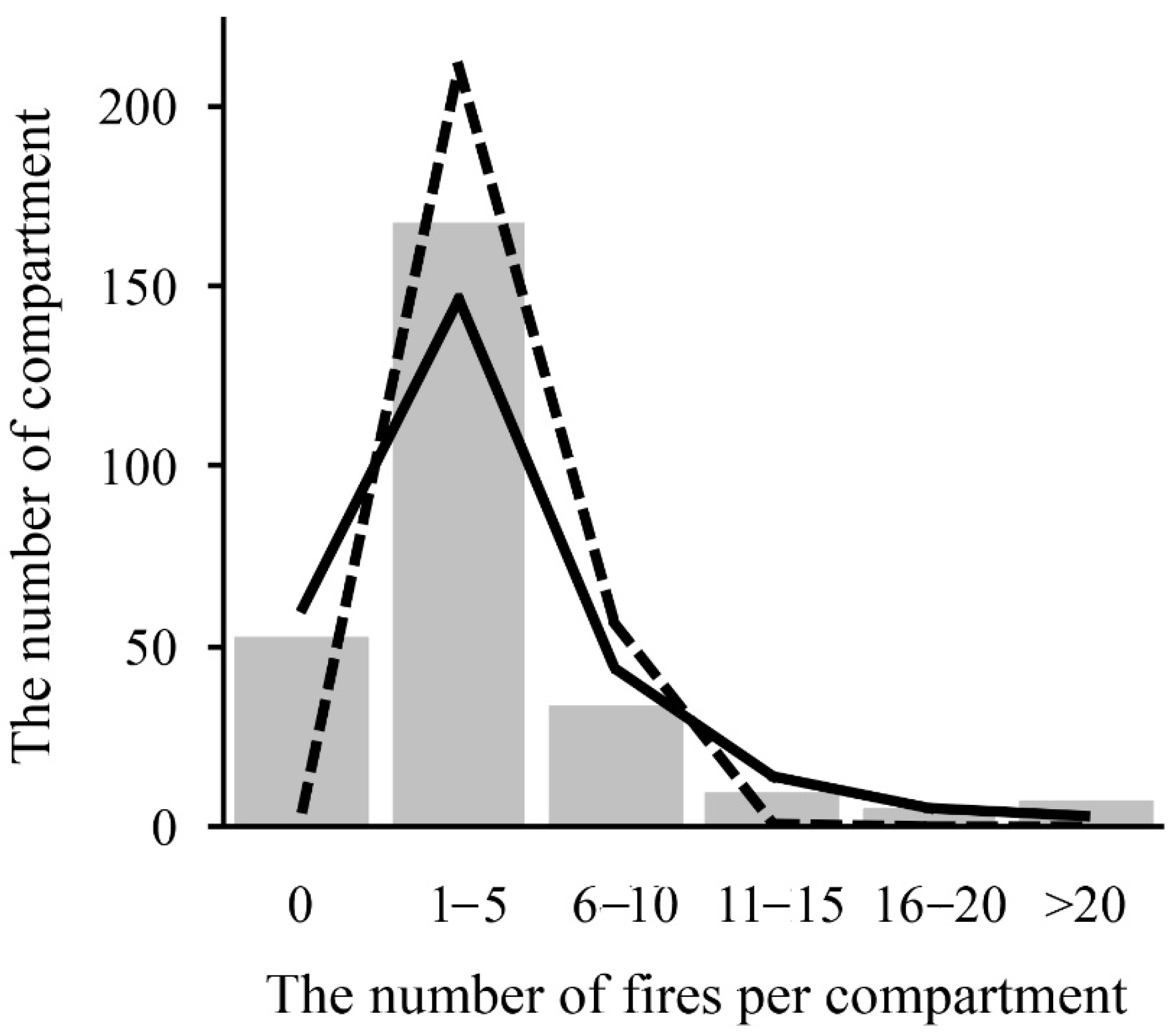
3.4. The Distribution of Fire-Affected Compartments

We analyzed the changes in the number of compartments featuring different “burning modes” between 1948–1970 and 1990–2014. For this, for each of the 273 compartments, one of four burning modes was determined: (1) compartments in which no fires occurred for the whole time; (2) compartments in which the number of fires increased from 1948–1970 to 1971–1990 and from 1971–1990 to 1991–2014; (3) compartments in which the number of fires decreased from 1948–1970 to 1971–1990 and from 1971–1990 to 1991–2014; (4) compartments in which the number of fires from showed the opposite trends over the three studied periods.
In most compartments, the number of fires did not show a consistent trend (Table 3). The number of ISR compartments with an increasing number of fires was 2.6 times higher than the number of compartments exhibiting a decreasing trend. Many compartments with an increasing number of fires (18) were on the ISR boundaries, while the seven compartments with a declining number of fires were confined to the reserve core. The proportions of compartments with different burning modes at the ISR boundary and in the core were significantly different: χ2 = 8.43; dF = 3; p = 0.0379.

4. Discussion

Our results are founded on the uniquely long series of direct fire records in Russia. The ISR is one of the oldest nature reserves in Russia. This made it possible to reconstruct in detail the distribution of fires over 67 years on a spatial scale of approximately 1 × 1 km. Fire datasets similar in spatial resolution and duration were analyzed for Spain—1890–2013 [37] and 1974–2015 [38]; Italy—1961–2017 [39]; Canada—1916–1998 [40]; China—1966–2005 [14].
The general increase in the number of fires in the ISR over the last 60–70 years was accompanied by a change in the localization of fires (Figure 5). The temporal changes in the spatial distribution of fires resulted in (1) an increase in the heterogeneity of the fire distribution and (2) an increase in the fire occurrence at the peripheral sections of the reserve. Our results are consistent with the conception that the spatial distribution of fires usually changes with time [9,37,38,39,40]. However, an increase in the number of fires by present times in other regions is not always observed. The number of fires has been decreasing from the past to the present [38,39]. In some works [9,37], changes across historical periods are not unidirectional.
The temporal dynamics of the number of fires is known for some of the Ural reserves: Pechoro-Ilychsky [28,29,41]; Visimsky [42]; Denezhkin Kamen [30]. The impact of availability territory and terrain characteristics on the location of burnt areas was investigated for the Pechora-Ilych Reserve [29,41]. Studies in the reserves dominated by coniferous vegetation in the north of the Urals show that they rarely burn. When fires do occur, these are often crown fires that develop under extreme drought, covering the areas hundreds and thousands of hectares. The ISR pine forests burn more often, although the fires usually spread over a small area. Earlier, we studied some features of post-fire successions in the ISR [43]. The ground fires predominate. They usually spread over a small area and do not become catastrophically stand-replacing. At the burnt areas, a thin layer of shrubs consists of Chamaecytisus ruthenicus (Fisch. ex Woloszcz.) Klaskova, Rubus idaeus L., and Sorbus aucuparia L. The herbaceous layer is fragmented, and its cover is 15–30%. The differences in fire type are also determined by the fact that the ISR is located in a densely populated area, while the reserves in the north of the Urals are difficult to access.
We showed a strong non-stationarity in the spatial pattern of fire occurrence during the 67 years of observations. At least one cluster of steadily burning compartments near the Trans-Siberian Railway has disappeared over the study period. Until 1961, the locomotives were steam engines, while after 1961, they started to use electric engines. This satisfactorily explains the reduction in the number of fires that often arose from sparks flying out of steam locomotive furnaces. After 1970, three previously non-existent clusters of regularly burning compartments have appeared. These dynamics might be related to land use changes in the region. The time periods in our work are chosen taking into account the changes in public life in our country. So, in 1966, the schedule of work and rest of the population changed. Until 1966, the working week in the country was 6 days with one day off. Since 1967, the working week has become 5 days with two days off. At the end of the first period, there was a change in the habits of people associated with recreation. The second period ended in 1990, because in 1991, the country underwent political changes. The USSR collapsed. This was accompanied by economic changes, new laws and regulations, and changes in people’s lifestyles. Our data show that the changes in the 1990s were accompanied by a noticeable impact on the number and spatial distribution of forest fires in the ISR. This is in good agreement with the fact that, in order to understand changes in the forests state, it is important to take into account the history of land use [38,40,44,45].
It is important to note that the territory of the ISR has always been and remains completely closed to visitors for recreation, excursions, fishing, hunting, etc. Only its forest-guards and scientists have the right to be present on the territory of the reserve. The current ISR protection regime allows the penetration of violators of the reserve regime that results in a high number of the ignitions. Poachers, prospectors, and tourists violating the borders and illegally entering the reserve contribute to fire ignitions. Our results support other studies, where dynamics of human-related ignitions have been suggested as the main factor behind the increasing number of fires in other forest regions [10,11,46,47,48,49]. Our results support this view, as most of the ISR fires were confined to the areas the most easily accessible to people in the reserve, such as the reserve boundaries and lake shores. The forest guards of ISR are well-informed about the frequent occurrence of fires in proximity of reserve borders.
The increase in the recorded number of fires over time may be partly a consequence of improving the system for detecting and registering fires in the ISR. The trend of changes in the spatial pattern of the fire distribution is more difficult to associate with the change in the efficiency of the fire detection system.
Previously, we [50] presented an analysis of the distribution of forest fires in one of the parts of the ISR, depending on some natural and anthropogenic factors. It has been established that, along with the forest type and its burning index class, the accessibility of the territory, expressed by proximity to the boundaries of the reserve, is a significant cause of forest fires. Considering the factors that likely affected the fire dynamics in the ISR between 1948 and 2014, we note the following. It is more difficult to imagine how relief, which remains unchanged, can determine the change in the forest fire susceptibility over time. The species composition, as well as the age and structure of forest stands, could change dramatically during 60–70 years. This could be the reason for the change in the forest fire susceptibility. Verifying the explanatory power of these hypotheses should be the subject of future studies.

5. Conclusions

The forest areas of ISR with regularly occurring fires show an aggregated distribution. The spatial pattern of the ISR forest fire frequency has changed dramatically from 1948 to 2014. Particularly, over the past 60–70 years, especially from the late 1980s to now, the heterogeneity of the fire distribution has increased. The increase in the total number of forest fires in the ISR is primarily due to the increase in the forest fire occurrences at the reserve boundary. The heterogeneity of changes in the fire frequency of the different parts of the reserve confirms the absence of an unambiguous climatic or weather effect on dynamics of forest fires [34].
A search for answers to new questions is required to reasonably discuss the reasons for the established temporal dynamics of the ISR forest fire frequency. The results obtained led to several verifiable hypotheses about the causes of increased forest fire frequency. These hypotheses are associated with the need to compare the relative importance of natural (topography, properties of forest stands, plant communities, and ecosystems) and anthropogenic causes of forest fires. Understanding the causes of pyrogenic dynamics is necessary for sustainable forest management and forest resource conservation.
The strong association of forest fires to the border compartments suggested that forests frequency to fire increases with human-driven fragmentation of the forest cover. Our results show the value of considering the spatial patterns of fire occurrence to fire management. In particular, identification of the most fire-prone sectors of the reserve should allow better allocation of available responses to support both preventive and active fire suppression activities.

Author Contributions

Conceptualization, D.V.; Methodology, D.V.; Formal Analysis, D.V., N.K. and L.P.; Investigation, N.K. and A.M.; Writing—Original Draft Preparation, D.V.; Writing—Review & Editing, D.V., N.K. and L.P. All authors have read and agreed to the published version of the manuscript.

Funding

This research received no external funding.

Institutional Review Board Statement

Not applicable.

Informed Consent Statement

Not applicable.

Data Availability Statement

Restrictions apply to the availability of these data. Data was obtained from Ilmensky Nature Reserve and are available from the authors with the permission of Ilmensky Nature Reserve.

Acknowledgments

The work was performed as part of the state assignments of the ISR of the South Urals Federal Research Center of Mineralogy and Geo-ecology, and the Institute of Plant and Animal Ecology of the Ural Branch of the Russian Academy of Sciences (122021000092-9), and the South Ural State University (National Research University).

Conflicts of Interest

The authors declare no conflict of interest.

References

  1. Goldammer, J.G.; Furyaev, V. Fire in Ecosystems of Boreal Eurasia: Ecological Impacts and Links to the Global System. In Fire in Ecosystems of Boreal Eurasia; Goldammer, J.G., Furyaev, V., Eds.; Springer: Dordrecht, The Netherlands, 1996; pp. 1–20. [Google Scholar]
  2. Littell, J.S.; Oneil, E.E.; McKenzie, D.; Hicke, J.A.; Lutz, J.A.; Norheim, R.A.; Elsner, M.M. Forest ecosystems, disturbance, and climatic change in Washington State, USA. Clim. Change 2010, 102, 129–158. [Google Scholar] [CrossRef] [Green Version]
  3. Silva, J.; Vaz, P.; Moreira, F.; Catry, F.; Rego, F.C. Wildfires as a major driver of landscape dynamics in three fire-prone areas of Portugal. Landsc. Urban Plan. 2011, 101, 349–358. [Google Scholar] [CrossRef] [Green Version]
  4. Yefremov, D.F.; Shvidenko, A.Z. Long-term environmental impact of catastrophic forest fires in Russia’s Far East and their contribution to global processes. Int. For. Fire News 2004, 32, 43–49. [Google Scholar]
  5. Drobyshev, I.; Ryzhkova, N.; Eden, J.; Kitenberga, M.; Pinto, G.; Lindberg, H.; Krikken, F.; Yermokhin, M.; Bergeron, Y.; Kryshen, A. Trends and patterns in annually burned forest areas and fire weather across the European boreal zone in the 20th and early 21st centuries. Agric. For. Meteorol. 2021, 306, 108467. [Google Scholar] [CrossRef]
  6. Drobyshev, I.; Niklasson, M.; Angelstam, P.; Majewski, P. Testing for anthropogenic influence on fire regime for a 600-year period in the Jaksha area, Komi Republic, East European Russia. Can. J. For. Res. 2004, 34, 2027–2036. [Google Scholar] [CrossRef] [Green Version]
  7. Fauria, M.M.; Johnson, E.A. Large-scale climatic patterns control large lightning fire occurrence in Canada and Alaska forest regions. J. Geophys. Res. 2006, 111, G04008. [Google Scholar] [CrossRef] [Green Version]
  8. Coops, N.C.; Hermosilla, T.; Wulder, M.A.; White, J.C.; Bolton, D.K. A thirty year, fine-scale, characterization of area burned in Canadian forests shows evidence of regionally increasing trends in the last decade. PLoS ONE 2018, 13, e0197218. [Google Scholar] [CrossRef]
  9. Hanes, C.C.; Wang, X.; Jain, P.; Parisien, M.A.; Little, J.M.; Flannigan, M.D. Fire-regime changes in Canada over the last half century. Can. J. For. Res. 2019, 49, 256–269. [Google Scholar] [CrossRef]
  10. Arienti, M.C.; Cumming, S.G.; Krawchuk, M.A.; Boutin, S. Road network density correlated with increased lightning fire incidence in the Canadian western boreal forest. Int. J. Wildland Fire 2009, 18, 970–982. [Google Scholar] [CrossRef]
  11. Flannigan, M.D.; Krawchuk, M.A.; de Groot, W.J.; Wotton, B.M.; Gowman, L.M. Implications of changing climate for global wildland fire. Int. J. Wildland Fire 2009, 18, 483–507. [Google Scholar] [CrossRef]
  12. Lovreglio, R.; Leone, V.; Giaquinto, P.; Notarnicola, A. Wildfire cause analysis: Four case-studies in southern Italy. iForest-Biogeosci. For. 2010, 3, 8–15. [Google Scholar] [CrossRef] [Green Version]
  13. Ganteaume, A.; Camia, A.; Jappiot, M.; San-Miguel-Ayanz, J.; Long-Fournel, M.; Lampin, C. A Review of the Main Driving Factors of Forest Fire Ignition Over Europe. Environ. Manag. 2013, 51, 651–662. [Google Scholar] [CrossRef] [PubMed] [Green Version]
  14. Wu, Z.; He, H.S.; Yang, J.; Liu, Z.; Liang, Y. Relative effects of climatic and local factors on fire occurrence in boreal forest landscapes of north-eastern China. Sci. Total Environ. 2014, 493, 472–480. [Google Scholar] [CrossRef] [PubMed]
  15. Shvidenko, A.Z.; Schepaschenko, D.G. Climate change and wildfires in Russia. Contemp. Probl. Ecol. 2013, 6, 683–692. [Google Scholar] [CrossRef]
  16. Gillett, N.P.; Weaver, A.J.; Zwiers, F.W.; Flannigan, M.D. Detecting the effect of climate change on Canadian forest fires. Geophys. Res. Lett. 2004, 31, L18211. [Google Scholar] [CrossRef] [Green Version]
  17. Westerling, A.L.; Hidalgo, H.G.; Cayan, D.R.; Swetnam, T.W. Warming and Earlier Spring Increase Western U.S. Forest Wildfire Activity. Science 2006, 313, 940–943. [Google Scholar] [CrossRef] [Green Version]
  18. Seidl, R.; Schelhaas, M.J.; Rammer, W.; Verkerk, P.J. Increasing forest disturbances in Europe and their impact on carbon storage. Nat. Clim. Change 2014, 4, 806–810. [Google Scholar] [CrossRef] [Green Version]
  19. Gorbatenko, V.P.; Gromnitskaya, A.A.; Konstantinova, D.A.; Ershova, T.V.; Nechepurenko, O.Y. Assessing the role of climatic factors in the formation and spread of forest fires in Tomsk oblast. Tomsk State Univ. J. 2015, 395, 233–240. [Google Scholar] [CrossRef]
  20. Ponomarev, E.I.; Kharuk, V.I. Wildfire occurrence in forests of the Altai–Sayan region under current climate changes. Contemp. Probl. Ecol. 2016, 9, 29–36. [Google Scholar] [CrossRef]
  21. Kelly, R.; Chipman, M.; Higuera, P.E.; Stefanova, I.; Brubaker, L.B.; Hu, F.S. Recent burning of boreal forests exceeds fire regime limits of the past 10000 years. Proc. Natl. Acad. Sci. USA 2013, 110, 13055–13060. [Google Scholar] [CrossRef] [Green Version]
  22. Maingi, J.K.; Henry, M.C. Factors influencing wildfire occurrence and distribution in eastern Kentucky, USA. Int. J. Wildland Fire 2007, 16, 23–33. [Google Scholar] [CrossRef] [Green Version]
  23. Verdu, F.; Salas, J.; Vega-García, C. A multivariate analysis of biophysical factors and forest fires in Spain, 1991–2005. Int. J. Wildland Fire 2012, 21, 498–509. [Google Scholar] [CrossRef]
  24. Adab, H. Landfire hazard assessment in the Caspian Hyrcanian forest ecoregion with the long-term MODIS active fire data. Nat. Hazards 2017, 87, 1807–1825. [Google Scholar] [CrossRef]
  25. Sukhinin, A.I.; French, N.; Kasischke, E.S.; Hewson, J.H.; Soja, A.J.; Csiszar, I.A.; Hyer, E.; Loboda, T.; Conrad, S.; Romasko, V.I.; et al. AVHRR-based mapping of fires in Russia: New products for fire management and carbon cycle studies. Remote Sens. Environ. 2004, 93, 546–564. [Google Scholar] [CrossRef]
  26. Koba, V.P.; Zhigalova, T.P. Climatic factors and the dynamics of fires in the forests of the Crimean Mountains. Contemp. Probl. Ecol. 2015, 8, 824–829. [Google Scholar] [CrossRef]
  27. Malenko, A.A.; Malinovskikh, A.A.; Chichkarev, A.S. The dynamics of fire occurrence frequency in the forests of the south of West Siberia. Altai State Agrar. Univ. Bull. 2015, 6, 68–72. (In Russian) [Google Scholar]
  28. Megalinskaya, I.Z.; Tertitsa, T.K. On the issue of fires in the pine forest area of the Pechora-Ilych Nature Reserve. In Proceedings of the Conservation Management in Russia: Principles, Problems, Priorities, Zhigulevsk, Russia, 4–8 September 2002. (In Russian). [Google Scholar]
  29. Lisitsyna, O.V.; Aleinikov, A.A.; Vladimirova, N.A.; Krylov, A.M.; Simakin, L.V. The impact of availability territory and terrain characteristics on location of burnt areas in dark coniferous forests Pechora-Ilich Nature Reserve. For. Eng. J. 2017, 7, 49–58. [Google Scholar] [CrossRef] [Green Version]
  30. Aleinikov, A.A.; Balushta, L.P.; Vladimirova, N.A.; Kvashnina, A.E. Typification of forest damage rates in the burned areas of the "Denezhkin Kamen" Russian Federal Nature Reserve (Ural Mountains). For. Eng. J. 2019, 8, 30–37. [Google Scholar] [CrossRef]
  31. Fernández-Álvarez, M.; Armesto, J.; Picos, J. LiDAR-Based Wildfire Prevention in WUI: The Automatic Detection, Measurement and Evaluation of Forest Fuels. Forests 2019, 10, 148. [Google Scholar] [CrossRef] [Green Version]
  32. Skowronski, N.S.; Gallagher, M.R.; Warner, T.A. Decomposing the Interactions between Fire Severity and Canopy Fuel Structure Using Multi-Temporal, Active, and Passive Remote Sensing Approaches. Fire 2020, 3, 7. [Google Scholar] [CrossRef] [Green Version]
  33. García-Cimarras, A.; Manzanera, J.A.; Valbuena, R. Analysis of Mediterranean Vegetation Fuel Type Changes Using Multitemporal LiDAR. Forests 2021, 12, 335. [Google Scholar] [CrossRef]
  34. Chibilev, A.A.; Veselkin, D.V.; Kuyantseva, N.B.; Chashchina, O.E.; Dubinin, A.E. Dynamics of forest fires and climate in Ilmen nature reserve, 1948–2013. Dokl. Earth Sci. 2016, 468, 619–622. [Google Scholar] [CrossRef]
  35. Gribova, S.A.; Isachenko, T.I.; Lavrenko, E.M. Vegetation of the European Part of the USSR; Nauka: Leningrad, Russia, 1980. (In Russian) [Google Scholar]
  36. A Manual on Acoustic Surveys: Sampling Methods for Acoustic Surveys. 1981. Available online: http://www.fao.org/docrep/003/x6602e/x6602e0d.htm (accessed on 15 November 2021).
  37. Montiel-Molina, C.; Vilar, L.; Romao-Sequeira, C.; Karlsson, O.; Galiana-Martin, L.; de Lomana, G.M.; Palacios-Estremera, M.T. Have historical land use/land cover changes triggered a fire regime shift in Central Spain? Fire 2019, 2, 44. [Google Scholar] [CrossRef] [Green Version]
  38. Rodrigues, M.; Jimenez-Ruano, A.; de la Riva, J. Fire regime dynamics in mainland Spain. Part 1: Drivers of change. Sci. Total Environ. 2020, 721, 135841. [Google Scholar] [CrossRef]
  39. Carlucci, M.; Zambon, I.; Colantoni, A.; Salvati, L. Socioeconomic development, demographic dynamics and forest fires in Italy, 1961-2017: A time-series analysis. Sustainability 2019, 11, 1305. [Google Scholar] [CrossRef] [Green Version]
  40. Lefort, P.; Gauthier, S.; Bergeron, Y. The influence of fire weather and land use on the fire activity of the Lake Abitibi Area, Eastern Canada. For. Sci. 2003, 49, 509–521. Available online: https://www.researchgate.net/publication/233706261 (accessed on 15 March 2022).
  41. Aleinikov, A.A. The fire history in pine forests of the plain area in the Pechora-Ilych Nature Biosphere Reserve (Russia) before 1942: Possible anthropogenic causes and long-term effects. Nat. Conserv. Res. 2019, 4, 21–34. [Google Scholar] [CrossRef] [Green Version]
  42. Belyaeva, N.V. Reaction of plant species belonging to different ecological and biological groups to a fire in the forests of the Visimsky Nature Reserve. In Proceedings of the Problems of specially protected natural territories of the European North, Syktyvkar, Russia, 25–29 October 2004. (In Russian). [Google Scholar]
  43. Chashchina, O.E.; Kuyantseva, N.B.; Mumber, A.G.; Potapkin, A.B.; Veselkin, D.V. Ground vegetation of the pine forest affected by forest fires in the gradient of emissions of the Karabash Copper Smelter. Vestn. Orenbg. State Pedagog. Univ. Electron. Sci. J. 2017, 4, 44–53, (In Russian with English abstract). [Google Scholar]
  44. Granstrom, A.; Niklasson, M. Potentials and limitations for human control over historic fire regimes in the boreal forest. Philos. Trans. R. Soc. B 2008, 363, 2353–2358. [Google Scholar] [CrossRef] [Green Version]
  45. Gimmi, U.; Wohlgemuth, T.; Rigling, A.; Hoffmann, C.W.; Burgi, M. Land-use and climate change effects in forest compositional trajectories in a dry Central-Alpine valley. Ann. For. Sci. 2010, 67, 701. [Google Scholar] [CrossRef]
  46. Mollicone, D.; Eva, H.D.; Achard, F. Human role in Russian wildfires. Nature 2006, 440, 436–437. [Google Scholar] [CrossRef] [PubMed]
  47. Zamolodchikov, D.G.; Grabovsky, V.I.; Shulyak, P.P.; Chestnykh, O.V. The impacts of fires and clear-cuts on the carbon balance of Russian forests. Contemp. Probl. Ecol. 2013, 6, 714–726. [Google Scholar] [CrossRef]
  48. Ganteaume A, Long-Fournel M Driving factors of fire density can spatially vary at the local scale in south-eastern France. Int. J. Wildland Fire 2015, 24, 650–664. [CrossRef]
  49. Shvetsov, E.G.; Kukavskaya, E.A.; Shestakova, T.A.; Laflamme, J.; Rogers, B.M. Increasing fire and logging disturbances in Siberian boreal forests: A case study of the Angara region. Environ. Res. Lett. 2021, 16, 115007. [Google Scholar] [CrossRef]
  50. Pustovalova, L.A.; Chashchina, O.E.; Kuyantseva, N.B.; Mumber, A.G.; Veselkin, D.V. Dependence of frequency of fires in the Ilmensky Reserve on the forest type and accessibility of the territory. In Proceedings of the Aerospace methods and GIS-technologies in forestry, forest management and ecology, Moscow, Russia, 22–24 April 2019; Available online: http://www.cepl.rssi.ru/confs/ASGIS2019/files/ASGIS2019_Abstract_book.pdf (accessed on 15 March 2022). (In Russian with English abstract).
Figure 1. Location of the study area: (a) in Russia and (b) in the world.
Forests 13 00528 g001
Figure 2. The spatial distribution of the zones of the Ilmensky Reserve.
Forests 13 00528 g002
Figure 3. The spatial distribution of the total number of fires recorded in the compartments of the Ilmensky Reserve in 1948–2014.
Forests 13 00528 g003
Figure 4. The approximations of the distribution of the number of fires in the compartments of the Ilmensky Reserve (gray bars) by the Poisson distribution (dashed line) and the Inverse Binomial distribution (solid line).
Forests 13 00528 g004
Figure 5. The spatial distribution of the number of fires per compartment per 10 years in (a) 1948–1970, (b) 1971–1990, and (c) 1991–2014.
Forests 13 00528 g005
Table 1. The distribution parameters for the number of fires in the compartments of the Ilmensky Reserve in 1948–1970, 1971–1990, and 1991–2014.
ParameterYears
1948–19701971–19901991–2014
Number of years232024
The sum of fires for the period261316506
The number of fires per compartment per 10 years:
Minimal0.000.000.00
Maximal4.807.0017.50
Median0.000.000.40
Mean0.410.580.77
Dispersion0.470.862.98
The correspondence of the distribution of the fire frequencies per compartment to the distributions of (in all cases dF = 5):
Poissonχ2347.39337.24449.64
p<0.0001<0.0001<0.0001
Inverse Binomialχ23.947.644.59
p0.55860.17740.4674
Table 2. The number of fires per compartment and decade in different zones of the Ilmensky Reserve in 1948–1970, 1971–1990, and 1991–2014 *.
Spatial ZonesYears
1948–19701971–19901991–2014
Boundary0.46 (0.00–0.40)0.74 (0.00–1.00)1.33 (0.00–1.70)
Buffer0.37 (0.00–0.40)0.49 (0.00–0.50)0.56 (0.00–0.80)
Core0.38 (0.00–0.40)0.48 (0.00–1.00)0.31 (0.00–0.40)
* arithmetic mean with interquartile range given in parentheses.
Table 3. Compartment shares (percentages) with different burning modes in different spatial zones of the Ilmensky Reserve *.
Spatial ZonesTotal Compartment NumberCompartment Burning Mode
No FiresThe Number of Fires Has IncreasedThe Number of Fires has DecreasedThe Number of Fires Did Not Vary Directionally
Boundary9918.2
(11.7–27.0)
18.2
(11.7–27.0)
2.0
(0.1–7.5)
61.6
(51.8–70.6)
Buffer9917.2
(10.9–25.9)
12.1
(6.9–20.2)
4.0
(1.3–10.3)
66.7
(56.9–75.2)
Core7522.7
(14.6–33.4)
5.3
(1.7–13.3)
9.3
(4.3–18.3)
62.7
(51.3–72.8)
All compartments27319.1
(14.8–24.1)
12.5
(9.0–16.9)
4.7
(2.7–8.1)
63.7
(57.9–69.2)
* adjusted Wald confidence intervals are given in parentheses.
Publisher’s Note: MDPI stays neutral with regard to jurisdictional claims in published maps and institutional affiliations.

