70 Years of Land Use/Land Cover Changes in the Apennines (Italy): A Meta-Analysis


1
Department of Agricultural, Food and Environmental Sciences, Marche Polytechnic University, Via Brecce Bianche 10, 60131 Ancona (AN), Italy
2
Department of Agricultural, Forest and Food Sciences, University of Turin, Largo Paolo Braccini 2, 10095 Turin (TO), Italy
*
Author to whom correspondence should be addressed.
Forests 2018, 9(9), 551; https://0-doi-org.brum.beds.ac.uk/10.3390/f9090551
Submission received: 8 August 2018
/
Revised: 4 September 2018
/
Accepted: 7 September 2018
/
Published: 8 September 2018
(This article belongs to the Special Issue Forest Landscape Ecology: Linking Past, Present, and Future Data)
Abstract
:Land use science usually adopts a case study approach to investigate landscape change processes, so we considered a meta-analysis an appropriate tool for summarizing general patterns and heterogeneous findings across multiple case studies over a large geographic area. Mountain landscapes in the Apennines (Italy) have undergone significant variations in the last century due to regional and national socio-economic changes. In this work, we reviewed 51 manuscripts from different databases and examined 57 case studies. We explored heterogeneous data sets, adopting a stepwise approach to select the case studies: Step 1, a general overview of the main studies; Step 2, an analysis of the features of the study sites and of land-use/cover transitions; Step 3, a landscape pattern analysis. We standardized the processing methods to obtain a new set of homogeneous data suitable for comparative analysis. After some pre-processing of the selected paper due to the broad heterogeneity of the data, we calculated common landscape metrics ex novo. We obtained digital images used to perform automatic segmentation with eCognition Developer 64 software. Our review indicated that most case studies were in Central and Southern Italy, 83% were examined at local scale, 77% carried out change detection, but only 38% included both change detection and landscape spatial pattern analysis. The results revealed a clear trend of forest expansion (+78%) and the reduction of croplands (−49%) and grasslands (−19%). We did not find significant changes in the landscape spatial patterns.
1. Introduction
Climate change and land use/land cover changes (LULCC) are considered to be drivers of global importance [1,2] affecting society and biosphere systems [3,4]. LULCC is commonly perceived to be a global process [5], although the nature and extent of changes occurring at broader scales (regional and global) should to be quantified to understand human-driven dynamics on the earth’s surface [6,7]. The impact of humans on the biosphere has been so significant that scientists recently introduced the “Anthropocene” concept whereby planet Earth is shifting to a new geological epoch in which human activities are severely altering the natural environment [8]. It is very important to study landscape changes at different spatial and temporal scales [9,10] and to provide more standardized approaches given the wide diversity of methods and data sources used [11]. In recent decades, improvements in remote sensing (RS) techniques and the increased availability of RS data [12] facilitated the analysis of LULCC worldwide [13].
In anthropogenic ecoregions like the Mediterranean basin, LULCC are of extreme interest because they can affect the conservation of “cultural landscapes” [14,15]. In Italy for example, the literature on LULCC has increased in the last three decades. Scientific works are available for the Alps in particular, a transnational mountain range studied by Italian, French, Swiss, and Austrian researchers [16,17]. The Apennines—the main peninsular orographic system—have also merited attention due to the significant landscape changes since World War II. The Alps and Apennines together cover about 35% of the entire surface area of Italy [18]. Both have been affected by the presence and activities of man throughout the millennia, but given their lower elevation, greater accessibility, and more intensive livestock transhumance, the Apennines show clearer signs of change. The dwindling human presence and pastoral activities in many mountain areas has progressively triggered secondary ecological successions that have changed the physiognomy of the landscape in recent decades and altered its structure and functions. A significant study conducted over 50 years (1950–2000) at national scale in six main geographic areas found a significant increase in forest cover and a decrease in agricultural cover, explained by the population decrease in both mountain systems [19].
The Apennines were heavily exploited for firewood, charcoal production, and wood pasture for many centuries until around 1960. National reforestation programs started before WW2 to reduce the severe slope erosion in mountainous and hilly areas and continued in the 1950s, and 1960s in particular, adding about 760,000 ha of plantations (mainly conifer tree species) in the Apennines [18,20]. Meanwhile rural population migration towards urban and industrial areas resulted in the general abandonment of rural activities and mountain settlements [21,22,23] causing natural forest gap-filling and natural reforestation dynamics (mainly broadleaf species). The reduction of forest-grassland ecotones also resulted in a reduction in plant species diversity [24], contributing to the disappearance of “cultural landscapes” [25].
The increasing percentage of land subject to these changes in land use/land cover and resulting changes in ecological landscape patterns led to more detailed studies being carried out to quantify and describe these changes and their effects on mountain ecosystems more clearly. The interdisciplinary nature of LULCC studies and increasing amount of published literature can hamper the efficient tracking of the latest updates and possible connections among the different studies [26]. Several LULCC studies are single case studies providing local results and not suited towards generalization at regional or national levels. In order to compare local case studies, they have to be fit into a common framework to analyze processes using the same methodological and conceptual approaches [27]. Therefore, the aims of this review were: (i) to collect all the existing literature concerning the LULCC in the Apennines, and (ii) conduct a meta-analysis of selected studies to detect possible common patterns over the past 70 years. This work has been challenging due to the wide heterogeneity of sources, geographic locations, and extent of study areas and different methods applied [19].
2. Materials and Methods
2.1. Literature Search and Data Extraction
We carried out a search using ISI Web of Science, Elsevier Scopus databases, and Google Scholar up to December 2017 to analyze the published Italian and English literature on LULCC in the Apennines and adjacent areas, using the following keyword combinations: land use change* OR land cover change* OR landscape dynamics* AND Apennines*. We included studies carried out in Eastern Sicilian mountains considered to be the orographic prolongation of the Apennines [28]. We included reports, book chapters, proceedings of Italian and international conferences, PhD theses, and other grey literature.
The selection of research studies included in the meta-analysis was based on three criteria: (i) location of study sites in the Apennines; (ii) availability of land use/land cover transition data in a suitable time interval; (iii) availability of data on forest-cover categories. We did not consider elevation as a selection criterion.
We adopted a stepwise approach for case studies eligible for the meta-analysis: (i) studies with comparable descriptive information (Step 1); (ii) studies reporting suitable topographic, climatic and anthropogenic impact data and/or that provide LULC (land use/land cover) data (Step 2); (iii) studies providing thematic maps suitable for landscape pattern analysis (Step 3) (Table 1).
We first excluded the case studies that did not provide clear descriptive information such as geographic coordinates of the area or the type of analysis carried out (Step 1). The name, location, and surface of study sites, time-period of analysis, material used (aerial photos, satellite imageries, field data), type of overall land-use/cover categories, type of forest classes, and presence and type of computed landscape metrics were all considered to be necessary to compare the case studies. Selected sites were plotted (Figure 1) using the available coordinates or those assigned to the centroid of each study area. We ended up with 42 study sites out of the initial 57 (from 51 documents) after Step 1 of the selection process.
2.2. Study-Site Features
After further filtering, we reduced the list to 32 case studies (Step 2), We excluded four case studies (ID 23, 46, 47, 48) from the study-site description due to the lack of information, but considered them for the land-use/cover transition analysis. Study areas were digitally scanned from article maps and then geo-referenced in a GIS environment. We drew a circular area around the centroid, approximating the extension of each study site and a buffer area to include the entire surface area. We extracted: (i) zonal statistics referring to topographic, climatic, and anthropogenic variables over the circular buffer: mean elevation and slope (DEM 20 m -ISPRA); (ii) mean temperature and precipitation (WorldClim [74]); (iii) mean density of gridded livestock (cattle, goats, and sheep) from the Livestock Geo-Wiki database [75]; (iv) population density in 1951 and 2011 (Population Census of National Institute of Statistics); (v) mean road density (National Geoportal database); (vi) road-distance median (Italian National Geoportal) for a homogeneous description of the study sites. Real livestock data was scarce so the current presence of livestock was detected using models (livestock raster grids). Population density is given by weighted mean of inhabitants/km2 of all municipalities included in the buffer areas (both for 1951 and 2011) and the extension of each municipality. Road density was calculated by including both national and provincial roads in the buffer areas.
2.3. Land-Use/Land Cover Transitions
The analysis of transitions required the available data to be standardized since it was too heterogeneous as it had been classified with different land-use categories and processed using various analytical approaches. We therefore standardized the processing methods to obtain a new set of homogeneous data suitable for making comparisons. Firstly, we merged similar LULC categories and obtained eight homogeneous ones: forests (only broadleaf), shrublands, grasslands (dense and sparse grasslands, pastures, and meadows), croplands (all arable lands), unvegetated lands (bare soils, water surfaces and rocks), urban (infrastructure in general: towns, houses, private gardens, roads, and industrial plants), orchards (fruit tree plantations and groves), and plantations (generally conifer plantations). We tried to include all LULC transitions calculated in the selected studies into two-time intervals: ‘old’ between 1948 and 1968 and ‘new’ between 2000 and 2012. We calculated absolute (ha) and relative changes (%). We then focused on broadleaf forest cover to compare the dynamics of different study sites and the annual percentage rate of forest expansion was added to the general transition analysis.
2.4. Landscape Pattern Analysis
We selected 13 papers (Step 3) and calculated common landscape metrics ex novo after some pre-processing due to the wide heterogeneity of methods and indices used in the single studies. We obtained digital images of all the maps included in the selected articles and performed an automatic segmentation with eCognition Developer 64 software (scale parameter = 100, colour parameter = 5). Each segmented map was imported as vector data into a GIS environment and geo-referenced using ground control points (GCPs) from Bing-aerial web maps. The vector data was manually classified according to the eight land-use/cover categories identified for the transition analysis without altering the classification of the original sources. We ended up with two homogeneous geo-referenced maps (past and present) for each study site corresponding to the original maps from the relative papers.
Each map was rasterised into ASCII (American Standard Code for Information Interchange) format (20-m resolution). A total of 26 raster files (13 ‘old’ and 13 ‘new’) were imported into the Fragstat 4.2 software program [76] and processed to calculate 23 landscape indices. We selected five landscape metrics excluding those with high intercorrelation [77]: PAD patch density (number of patch/100 hectares), MPS mean patch size (hectares), MSI mean shape index, AGI aggregation index, and SDI Simpson’s diversity index. We explored landscape structure differences over time using a Wilcoxon paired test with the medians of index variations.
3. Results
3.1. Literature Search and Data Extraction
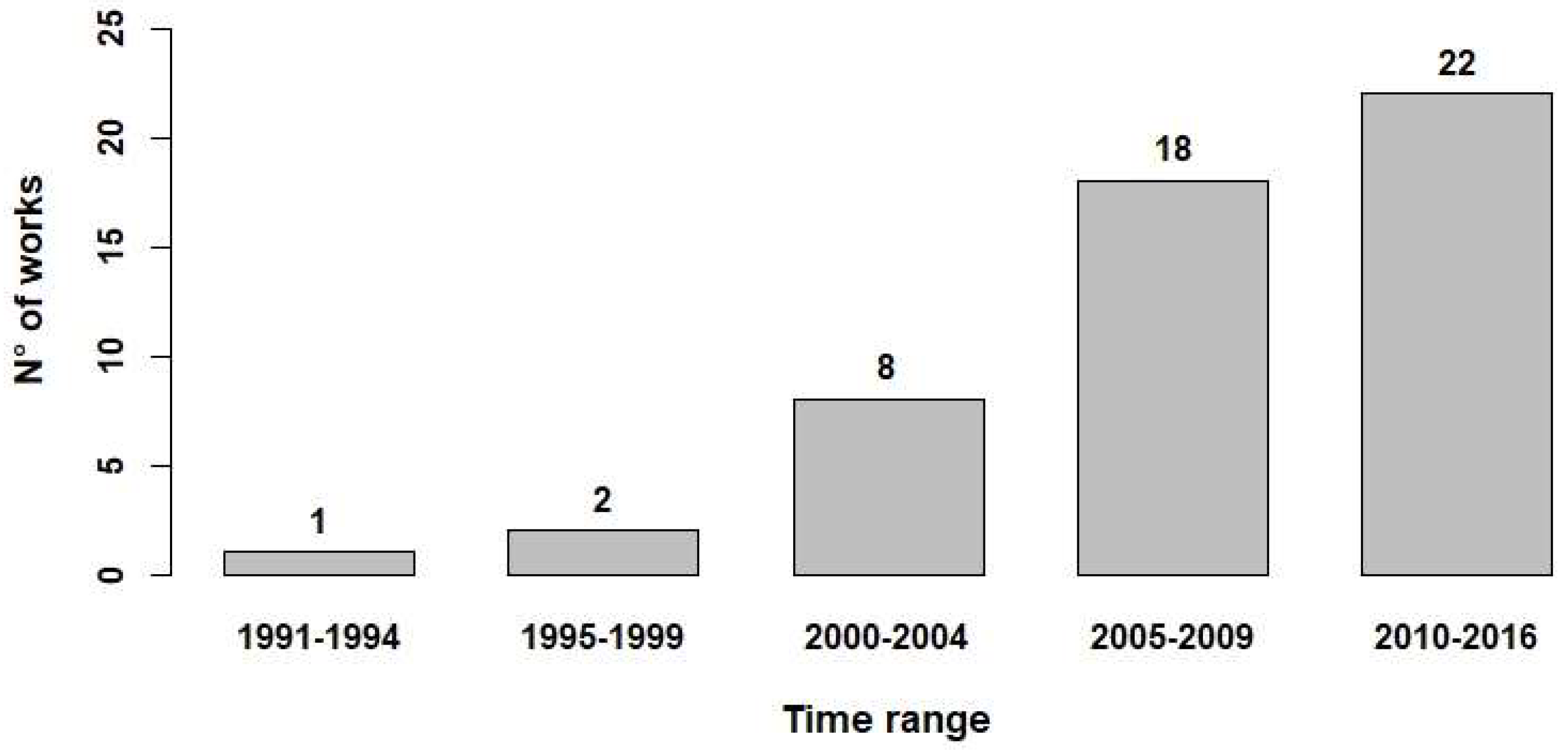
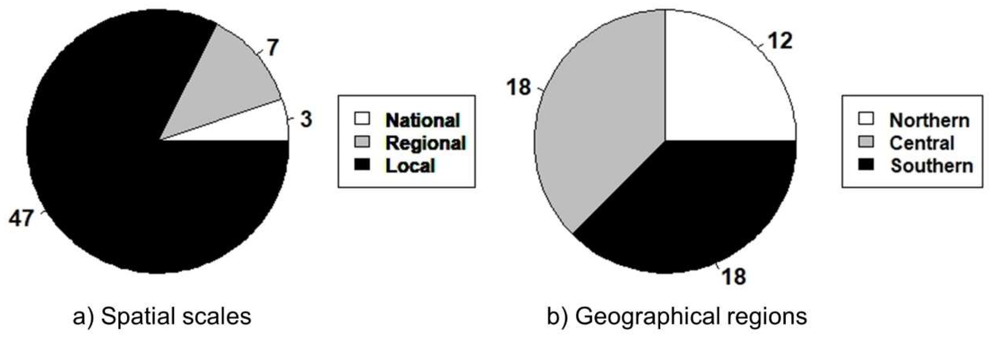
We collected 51 papers (including 57 case studies) comprising 34 scientific articles (27 indexed and 7 non-indexed) and 17 other works (reports, theses, proceedings, and book chapters) published between 1991 and 2016 (Table 1). Most of these works (78%) were published between 2005 and 2016 (Figure 2). 83% of the studies are at local scale and refer to single sites but with greatly varying sizes (from hundreds to thousands of hectares); 12% applied the LULCC analysis at regional scale (e.g., [32]) and only 5% at national scale, e.g., [19] (Figure 3a). The study sites are mostly located in the Central (37.5%) and Southern (37.5%) Apennines, with 25% in the Northern Apennines (Figure 3b).
Furthermore, 77% of the studies showed change detection, 40% carried out a landscape pattern analysis through landscape metrics but only 38% of the studies included both change detection and landscape metric analyses. Anthropogenic drivers such as population and grazing data were only considered in seven studies, the mean temporal extent of the change detection was 46 years, and the most common spatial resolution was a minimum mapping unit (MMU) of 100 m2. The studies including landscape metrics analysis used one to nine metrics. The variables used most frequently were the number of patches, mean patch size, Shannon’s diversity index and the landscape shape index. The most common keywords were “land-cover change” (47%) followed by “forest cover dynamics” (15%), and “vegetation patterns” (11%).
After the first selection step, we retained 42 case studies (Figure 1), mainly (64%) located in the mountainous areas of the Apennines. Different data sources were used for the LULCC analyses: 66% used aerial photos, 57% theme-based maps, 20% historical maps, and 19% satellite imagery. 30% of the papers used DEMs, but only 7% added ground control points (GCPs). Temporal frequencies used for change detections varied from two to seven chrono-sequences: the most common years were 1954 (16 studies), 1960 (6); 1990 (6); 2000 (10). The extension of the study areas ranged from 143 to 130,200 ha, excluding a few at regional/national-scale. The LULC categories varied considerably in relation to local differences: eight on average and three of them specifically related to forest or woodland types.
3.2. Study-Site Features
We extracted topographic, climatic and anthropogenic variables from 28 case studies (Step 2) (Table S1). Mean elevation ranged largely from 56 m to 1442 m a.s.l. and mean slope was between 7° and 33°. The most common livestock was sheep, followed by cattle and goats. Human population density decreased from 1951 to 2011 in 71% of selected sites, with a mean change of −9 inhabitants/km2 (±26 SD).
3.3. Land-Use/Cover Transitions
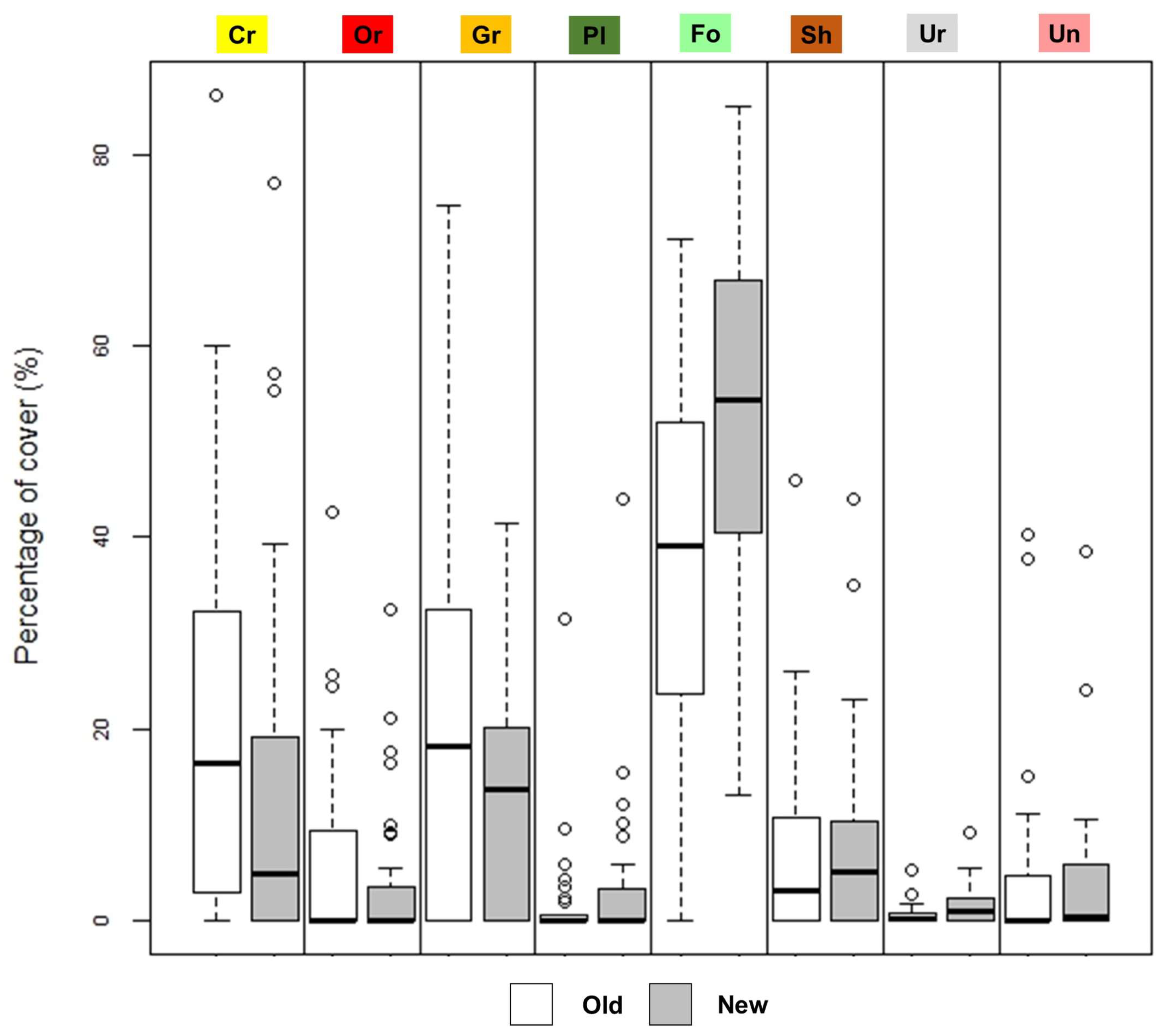
The most significant landscape change was the broadleaf forest (Fo) expansion, increasing from 36.5% to 54.4% of average cover (Figure 4). In the past, the minimum was 0% (SPA) and the maximum 71.1% (CSM). These values now range from 13% (LEA) to 85.1% (CDA). Average grasslands cover decreased from 21.9% to 12.4%. The highest value in the past was 74.6% (ROM) and is currently 41.4% (MOM). Cropland cover decreased from 20.9% to 13.2%, whereas shrub cover increased slightly from 7.4% to 7.8% (Figure 4). Unvegetated, urban, orchard, and plantation classes are outliers due to the high variability. However, an average of the past and present percentages show that Un is practically unchanged (around 4%). Urban areas showed a remarkable increase, doubling from 0.7% to 1.7%, along with conifer plantations which increased from 1.9% to 3.5%. Orchards decreased from 6.3% to 4.0%.
Considering the average relative change (averaged values of each study site) (Figure 5), forest increased by 78.0% (+7114 ha average, +18.6 ha min and +73,427 ha max). The rate of forest change varied from 0.16%/year (CSM) to 4.75%/yr (CAR) with a mean value of 1.01%/year. Grasslands and croplands decreased by 19.1% (−2982 ha) and 48.5% (−3621 ha) respectively. Shrublands showed very high variability in both directions but there was an overall increase of 125.4%. Urban cover tripled (+301.5%, +427 ha), whereas orchards decreased by 29.6% (−622 ha). Conifer plantations expanded by +47.9% (+507 ha) but only in eight sites.
3.4. Landscape Pattern Analysis
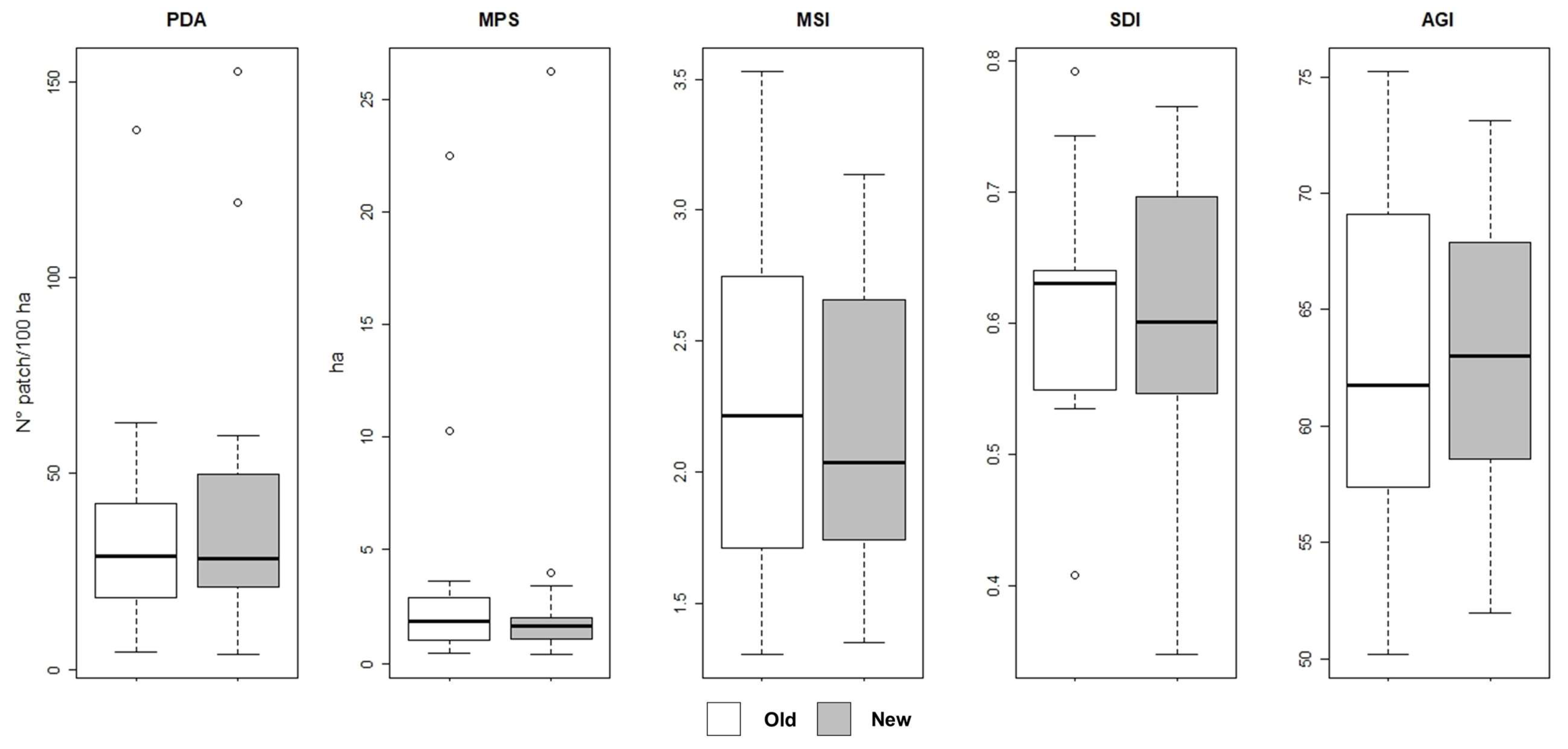
Landscape patterns were analyzed on 13 sites (Step 3). No significant differences (Wilcoxon paired test) were observed at the critical p-value of 0.05 testing ‘old’ vs. ‘new’ groups of metrics. Averaged PAD increased through time (from 37.2 to 43.9 patch/100 ha), whereas MPS and MSI decreased slightly. SDI remained stable over time and AGI increased slightly (Figure 6).
4. Discussion
The opportunities to measure and show LULCC are increasing rapidly thanks to developments in remote sensing platforms and sensors, GIS software, and access to specific databases. This also applies to areas like the Apennines which have often played second fiddle to the Alps. We did not find any literature before 1991, but interest in this area has been increasing since natural reforestation in rural and mountain areas has become so important, requiring a review of existing land management policies and habitat conservation strategies. New forest expansion has significant implications in terms of wood and non-wood products, carbon sequestration, slope erosion control, biodiversity conservation, recreation opportunities, and the value of ecosystem services in general [78]. Moreover, LULCC are closely linked to climate change affecting the extent, intensity and frequency of forest disturbances, such as wildfires [79,80].
The results of this study indicate increasing interest in LULCC analyses, especially in the Central Apennines [41,46,49]. These studies focused on both forested areas and agro-ecosystems (cropland and orchard areas) in addition to more extensive vegetation areas (shrubs and grasslands). Research was carried out in both mountainous areas (65% of the cases) and at lower-elevation sites (<600 m a.s.l.) (35%). Landscape metrics computation is usually necessary to comprehend change detection more easily, and the processes and patterns of landscape cover transitions. About 77% of the whole studies reviewed included the change-detection analysis but only 38% of them dealt with landscape pattern analysis. Since the first national planimetric and stereoscopic aerial photos coverage was carried on in 1954–1956 (G.A.I. flight), most of the studies dealt with those years [47,64]. Previous temporal studies depended on different sources such as local aerial photos, historical maps or local land registers [36].
The landscape investigated is mainly in mountain areas, so non-forest/forest transition was the most significant ecological process covered in the material reviewed. Broadleaf forests (natural forest) (Fo) were found to have expanded by 78% compared to the 48% expansion of planted forests (Pl). These two forest categories are generally very distinct due to their different origins. Conifer forests largely comprise Pinus spp. stands: they were planted throughout the 1900s for erosion control of overgrazed, steep slopesand to generate employment [18,19,20]. Broadleaf forest cover increased after agro-pastoral land was abandoned, especially after World War II. Permanent or temporary population migration from the mountains towards coastal and urban areas was common in the Mediterranean basin, and continues to this day [23,68,81]. The shift from extensive to intensive agricultural systems caused widespread abandonment of crops and grasslands, especially around mountain settlements [21,50,82]. A decrease in population density (−9 inhabitants/km2) occurred between 1951 and 2011. Natural secondary successions are common when anthropogenic pressure is reduced [24] and occurred in former grasslands and croplands [47,83] triggering shrub [29] and tree species [84] encroachment. These processes were also observed in other Mediterranean mountain areas in Greece [85], France [86], and Spain [24,87,88]. Our review confirmed that crops decreased by an overall average of 49%, pastures decreased by an overall average of 19% and shrub cover increased by 125%. Similar processes and trends occurred in the Alps even though the landscapes and plant species are different [89,90]. The recent decrease in livestock grazing in mountain areas and the subsequent abandonment of grasslands is widespread [19,50]. However, it is not easy to quantify this process since data is generally scarce. One of the few recorded analyses in the Central Apennines showed a 30.3% reduction in cows and Mediterranean buffalos and a 32.5% reduction in sheep and goats over a 40-year time span [50]. Our Step 2 data showed that the average number of sheep (18.2 heads/km2) is now higher. The invasive nature of natural forests at the expense of former crop areas and pastures contributed to the disappearance of “cultural landscapes” such as transhumance trails [25,91,92], shaped by the co-evolution of human activities with the ecosystems and biota over thousands of years [93]. Another significant change, although in relative terms, is the expansion of urban areas and infrastructure which has increased by 302% in the last 60–70 years. This process has a twofold explanation: one linked to the widespread dispersion of houses and infrastructures at all levels of elevation, and the second to the immediate detection of these elements due to the increasingly high quality of aerial images.
Further interpretation of these socio-environmental processes can be assumed from the changes in landscape patterns. The interpretation of landscape metrics can be challenging due to the numerous variables considered (e.g., type of site, land-use classes, and area extension). Moreover, the literature (Step 3) showed that landscape pattern analyses are highly fragmented. In general, the Apennines landscape could be expected to have lost some heterogeneity due to less human pressure, resulting in a more cohesive structure than in the past [51], however landscape indices calculated with standardized data and methods revealed non-significant differences between the past and the present landscape structures (Figure 6). The result showed a slight overall decrease in landscape diversity (SDI) and an increase in same-class patch aggregation (AGI) in a few articles that carried out accurate analyses [47,94]. However, the heterogeneous nature of the study sites, data sources (e.g., resolution), and methods used could have biased the analyses, which would suggest that further direct tests should be carried out. The overall simplification processes of the Apennines landscape as suggested by the literature does not exclude local increases in specific mosaic fragmentation due to initial forest and shrub encroachment in grasslands and unvegetated areas. Similar dynamics are also described in the inner valleys of the western and central Italian Alps, with an increase in patch density and a decrease in mean patch area in most sites, with a corresponding slight reduction of landscape diversity [95].
5. Conclusions
This meta-analysis aimed to check the state of the art of existing studies on LULCC in the Apennines and find possible common patterns of landscape transition. We reviewed national and international literature available in different databases and tried to standardize published and non-published datasets to provide comparable results. Case studies were selected according to three hierarchical steps based on the type and availability of information. Case studies were carried out at various elevations along the Apennines, especially in Central Italy. Authors adopted different analysis methods, generally using aerial photos but also other remotely-sensed data. The main process detected was the natural expansion of broadleaf (natural) forest on former grasslands and croplands caused by significant socio-economic changes. We detected ongoing landscape simplification occurring in inner mountain areas, but further analysis is necessary to confirm the intensity and rate of this process. These types of reviews that combine studies on large geographic areas to detect multi-scale changes in human-shaped environments are helpful in finding trade-offs between LULCC dynamics [96]. They also play a crucial role in the development of common management strategies and predicting future scenarios [27].
Supplementary Materials
The following are available online at https://0-www-mdpi-com.brum.beds.ac.uk/1999-4907/9/9/551/s1, Table S1: Zonal statistics of 28 case studies computed on a circular areas buffer approximating the size of the entire study site. Topographic variables: ELEVation, SLOPe. Climatic variables: TEMPerature, PRECipitation. Anthropic variables: CATTLE, GOAT, SHEEP, POPulation density on 1951, POPulation density on 2011, Road DEnsity and Road distance median.
Author Contributions
Acquisition of data, analysis and interpretation of data, and drafting of manuscript—F.M.; Analysis and interpretation of data, and critical revision—A.V.; Critical revision and editorial supervising—C.U.; Study conception and design, and critical revision—M.G.
Funding
This research received no external funding.
Acknowledgments
We wish to thank Patricia Crotty ([email protected]) for text editing and review.
Conflicts of Interest
The authors declare no conflict of interest.
References
- Foley, J.A.; Defries, R.; Asner, G.P.; Barford, C.; Bonan, G.; Carpenter, S.R.; Chapin, F.S.; Coe, M.T.; Daily, G.C.; Gibbs, H.K.; et al. Global consequences of land use. Science 2005, 309, 570–574. [Google Scholar] [CrossRef] [PubMed]
- Houghton, R.A. Revised estimates of the annual net flux of carbon to the atmosphere from changes in land use and land management 1850–2000. Tellus B Chem. Phys. Meteorol. 2003, 55, 378–390. [Google Scholar] [CrossRef]
- Gillanders, S.N.; Coops, N.C.; Wulder, M.A.; Gergel, S.E.; Nelson, T. Multitemporal remote sensing of landscape dynamics and pattern change: describing natural and anthropogenic trends. Prog. Phys. Geogr. 2008, 32, 503–528. [Google Scholar] [CrossRef]
- Skole, D.L.; Justice, C.O.; Townshend, J.R.G.; Janetos, A.C. A land cover change monitoring program: strategy for an international effort. Mitig. Adapt. Strat. Glob. Chang. 1997, 157–175. [Google Scholar] [CrossRef]
- Lambin, E.F.; Geist, H.J. Land-Use and Land-Cover Change Local Processes and Global Impacts; Springer-Verlag Berlin Heidelberg: Heidelberg, Genmany, 2006. [Google Scholar]
- Turner, B.L.; Kates, R.W.; Meyer, W.B. The earth as transformed by human action in retrospect. Ann. Assoc. Am. Geogr. 1994, 84, 711–715. [Google Scholar] [CrossRef]
- Klein Goldewijk, K. Estimating global land use change over the past 300 years. Glob. Biogeochem. Cycles 2001, 15, 417–433. [Google Scholar] [CrossRef]
- Steffen, W.; Crutzen, P.J.; McNeill, J.R. The anthropocene: Are humans now overwhelming the great forces of nature. Ambio 2007, 36, 614–621. [Google Scholar] [CrossRef]
- Ramankutty, N.; Foley, J.A.; Olejniczak, N.J. People on the land: Changes in global population and croplands during the 20th century. Ambio 2002, 31, 251–257. [Google Scholar] [CrossRef] [PubMed]
- Pongratz, J.; Reick, C.; Raddatz, T.; Claussen, M. A reconstruction of global agricultural areas and land cover for the last millennium. Glob. Biogeochem. Cycles 2008, 22. [Google Scholar] [CrossRef] [Green Version]
- Rozenstein, O.; Karnieli, A. Comparison of methods for land-use classification incorporating remote sensing and GIS inputs. Appl. Geogr. 2011, 31, 533–544. [Google Scholar] [CrossRef]
- Gutman, G.; Janetos, A.C.; Justice, C.O.; Moran, E.F.; Mustard, J.F.; Rindfuss, R.R.; Skole, D.; Turner, B.L., II; Cochrane, M.A. Land Change Science: Observing, Monitoring, and Understanding Trajectories of Change on the Earth’s Surface; Springer: Berlin, Genmany, 2004; Volume 6, ISBN 1402025610. [Google Scholar]
- Paudel, B.; Yi-Li, Z.; Shi-Cheng, L.; Lin-Shan, L.; Xue, W.; Khanal, N.R. Review of studies on land use and land cover change in Nepal. J. Mt. Sci. 2016, 13, 643–660. [Google Scholar] [CrossRef] [Green Version]
- Naveh, Z. Interactions of landscapes and cultures. Landsc. Urban Plan. 1995, 32, 43–54. [Google Scholar] [CrossRef]
- Godone, D.; Garbarino, M.; Sibona, E.; Garnero, G.; Godone, F. Progressive fragmentation of a traditional Mediterranean landscape by hazelnut plantations: The impact of CAP over time in the Langhe region (NW Italy). Land Use Policy 2014, 36, 259–266. [Google Scholar] [CrossRef] [Green Version]
- Romano, B.; Zullo, F. Landscape change in the European Mountain Areas Settlement of the Alps: Evolution and trajectories. RI-VISTA 2016, 88–109. [Google Scholar] [CrossRef]
- Zimmermann, P.; Tasser, E.; Leitinger, G.; Tappeiner, U. Effects of land-use and land-cover pattern on landscape-scale biodiversity in the European. Alps. Agric. Ecosyst. Environ. 2010, 139, 13–22. [Google Scholar] [CrossRef]
- Vacchiano, G.; Garbarino, M.; Lingua, E.; Motta, R. Forest dynamics and disturbance regimes in the Italian Apennines. For. Ecol. Manag. 2016. [Google Scholar] [CrossRef]
- Falcucci, A.; Maiorano, L.; Boitani, L. Changes in land-use/land-cover patterns in Italy and their implications for biodiversity conservation. Landsc. Ecol. 2007, 22, 617–631. [Google Scholar] [CrossRef]
- Piermattei, A.; Lingua, E.; Urbinati, C.; Garbarino, M. Pinus nigra anthropogenic treelines in the central Apennines show common pattern of tree recruitment. Eur. J. For. Res. 2016, 135, 1119–1130. [Google Scholar] [CrossRef]
- De Sillo, R.; De Sanctis, M.; Bruno, F.; Attorre, F. Vegetation and landscape of the Simbruini mountains (Central Apennines). Plant Sociol. 2012, 49, 3–64. [Google Scholar] [CrossRef]
- Frate, L.; Saura, S.; Minotti, M.; di Martino, P.; Giancola, C.; Carranza, M.L. Quantifying forest spatial pattern trends at multiple extents: An approach to detect significant changes at different scales. Remote Sens. 2014, 6, 9298–9315. [Google Scholar] [CrossRef]
- Bakudila, A.; Fassio, F.; Sallustio, L.; Marchetti, M.; Munafò, M.; Ritano, N. I comuni e le comunità appenninici: Evoluzione del territorio. Slowfood.it. Available online: http://www.slowfood.it/stati-generali-delle-comunita-dellappennino/ (accessed on 15 February 2018). (In Italian).
- Gartzia, M.; Alados, C.L.; Perez-Cabello, F. Assessment of the effects of biophysical and anthropogenic factors on woody plant encroachment in dense and sparse mountain grasslands based on remote sensing data. Prog. Phys. Geogr. 2014, 38, 201–217. [Google Scholar] [CrossRef] [Green Version]
- Zagaria, C.; Schulp, C.J.E.; Kizos, T.; Gounaridis, D.; Verburg, P.H. Cultural landscapes and behavioral transformations: An agent-based model for the simulation and discussion of alternative landscape futures in East Lesvos, Greece. Land Use Policy 2017, 65, 26–44. [Google Scholar] [CrossRef]
- Wang, Y.C.; Feng, C.C. Patterns and trends in land-use land-cover change research explored using self-organizing map. Int. J. Remote Sens. 2011, 32, 3765–3790. [Google Scholar] [CrossRef]
- Van Vliet, J.; Magliocca, N.R.; Büchner, B.; Cook, E.; Rey Benayas, J.M.; Ellis, E.C.; Heinimann, A.; Keys, E.; Lee, T.M.; Liu, J.; et al. Meta-studies in land use science: Current coverage and prospects. Ambio 2016, 45, 15–28. [Google Scholar] [CrossRef] [PubMed] [Green Version]
- Finetti, I.R. CROP PROJECT: Deep Seismic Exploration of the Central Mediterranean and Italy; Elsevier Science: Amsterdam, The Netherlands, 2005. [Google Scholar]
- Assini, S.; Filipponi, F.; Zucca, F. Land cover changes in an abandoned agricultural land in the Northern Apennine (Italy) between 1954 and 2008: Spatio-temporal dynamics. Plant Biosyst. 2014, 149, 807–817. [Google Scholar] [CrossRef]
- Filipponi, F. Spatio-temporal modeling of vegetation dynamic in an abandoned land of the Northern Apennine. In Proceedings of the IEEE GOLD Remote Sensing conference 2012, Rome, Italy, 4–5 June 2012. [Google Scholar]
- Vincini, M.; Lega, P. Studio della dinamica forestale e colturale nell’Appennino piacentino con l’impiego di immagini multitemporali e multisensore. Provincia.pc.it. Available online: http://www2.provincia.pc.it/cartografico/Cartografia/stud_elab_tem.htm (accessed on 1 February 2018). (In Italian).
- Brath, A.; Montanari, A.; Moretti, G. Assessing the effect on flood frequency of land use change via hydrological simulation (with uncertainty). J. Hydrol. 2006, 324, 141–153. [Google Scholar] [CrossRef]
- Mariani, M.C.; Villani, G.; Gherard, M.; Vianello, G.; Speranza, M. Trasformazioni della copertura vegetale e naturalità del paesaggio. In Ecologia e Governance del Paesaggio-Esperienze e prospettive; X Congresso Nazionale della Società Italiana di Ecologia del Paesaggio; Università degli studi di Bari: Bari, Italy, 2008; pp. 387–394. (In Italian) [Google Scholar]
- Farina, A. Upland farming systems of the Northern Apennines. In Conserving Biodiversity Outside Protected Area: The Role of Traditional Agro-Ecosystems; Halladay, P., Gilmour, D.A., Eds.; IUCN-The World Conservation Union: Gland, Switzerland, 1995; pp. 123–135. ISBN 2831702933. [Google Scholar]
- Farina, A. Recent changes of the mosaic patterns in a montane landscape (north Italy) and consequences on vertebrate fauna. Options Mediterr. 1991, 15, 121–134. [Google Scholar]
- Pezzi, G.; Maresi, G.; Conedera, M.; Ferrari, C. Woody species composition of chestnut stands in the Northern Apennines: The result of 200 years of changes in land use. Landsc. Ecol. 2011, 26, 1463–1476. [Google Scholar] [CrossRef]
- Benini, L.; Bandini, V.; Marazza, D.; Contin, A. Assessment of land use changes through an indicator-based approach: A case study from the Lamone river basin in Northern Italy. Ecol. Indic. 2010, 10, 4–14. [Google Scholar] [CrossRef]
- Agnoletti, M. Le dinamiche del paesaggio fra XIX e XX secolo. In Il paesaggio agro-forestale toscano, strumenti per l’analisi la gestione e la conservazione; MANUALE ARSIA: Firenze, Italy. (In Italian)
- Bonavita, A.; Calamini, G.; Pellegrini, P. Il recupero delle aree aperte di montagna: analisi delle variazioni dell’uso del suolo in due comuni della montagna pistoiese. L’Italia For. e Mont. 2007, 1, 1–14. (In Italian) [Google Scholar] [CrossRef]
- Agnoletti, M. The degradation of traditional landscape in a mountain area of Tuscany during the 19th and 20th centuries: Implications for biodiversity and sustainable management. For. Ecol. Manag. 2007, 249, 5–17. [Google Scholar] [CrossRef]
- Argenti, G.; Bianchetto, E.; Ferretti, F.; Giulietti, V.; Milandri, M.; Pelleri, F.; Romagnoli, P.; Signorini, M.; Venturi, E. Caratterizzazione di un’area pascoliva in fase di abbandono attualmente utilizzata in modo estensivo (S. Paolo in Alpe-S. Sofia, FC). Forest@ 2006, 3, 387–396. (In Italian) [Google Scholar] [CrossRef]
- Vazzano, E.; Quilghini, G.; Travaglini, D.; Nocentini, S. Changes in forest cover in the Foresta della Lama (Casentino Forests National Park) from Karl Siemon’s and Anton Seeland’s 1837 forest management plan. For.-Riv. di Selvic. ed Ecol. For. 2011, 8, 78–87. [Google Scholar] [CrossRef] [Green Version]
- Campiani, E.; Corticelli, S.; Garberi, M.L.; Gavagni, A.; Lorenzini, F. Evoluzione del territorio della Regione Emilia-Romagna: Analisi comparativa tra le due edizioni della carta dell’uso del suolo; Regione Emilia Romagna: Bologna, Italy, 2001. (In Italian) [Google Scholar]
- Bertacchi, A.; Onnis, A. Changes in the Forested Agricultural Landscape of the Pisan Hills (Tuscany, Italy). In Recent Dynamics of the Mediterranean Vegetation and Landascape; Mazzoleni, S., di Pasquale, G., Mulligan, M., di Martino, P., Rego, F., Eds.; Wiley: Chichester, UK, 2004; ISBN 0-470-09369-2. [Google Scholar]
- Geri, F.; Amici, V.; Rocchini, D. Human activity impact on the heterogeneity of a Mediterranean landscape. Appl. Geogr. 2010, 30, 370–379. [Google Scholar] [CrossRef]
- Rocchini, D.; Perry, G.L.W.; Salerno, M.; Maccherini, S.; Chiarucci, A. Landscape change and the dynamics of open formations in a natural reserve. Landsc. Urban Plan. 2006, 77, 167–177. [Google Scholar] [CrossRef] [Green Version]
- Bracchetti, L.; Carotenuto, L.; Catorci, A. Land-cover changes in a remote area of central Apennines (Italy) and management directions. Landsc. Urban Plan. 2012, 104, 157–170. [Google Scholar] [CrossRef]
- Cimini, D.; Tomao, A.; Mattioli, W.; Barbati, A.; Corona, P. Assessing impact of forest cover change dynamics on high nature value farmland in Mediterranean mountain landscape. Ann. Silvic. Res. 2013, 37, 29–37. [Google Scholar]
- Pelorosso, R. Land Cover e Land Use Change di Medio-Lungo Periodo in Provincia di Rieti: Analisi e Modellizzazione Delle Dinamiche Territoriali; Università degli studi della Tuscia–Viterbo: Viterbo, Italy, 2007. (In Italian) [Google Scholar]
- Pelorosso, R.; Leone, A.; Boccia, L. Land cover and land use change in the Italian central Apennines: A comparison of assessment methods. Appl. Geogr. 2009, 29, 35–48. [Google Scholar] [CrossRef]
- Peroni, P.; Ferri, F.; Avena, G.C. Temporal and spatial changes in a mountainous area of central Italy. J. Veg. Sci. 2000, 11, 505–514. [Google Scholar] [CrossRef]
- Gils, H.; Batsukh, O.; Rossiter, D.; Munthali, W.; Liberatoscioli, E.; van Gils, H.; Batsukh, O.; Rossiter, D.; Munthali, W.; Liberatoscioli, E. Forecasting the pattern and pace of Fagus forest expansion in Majella National Park, Italy. Appl. Veg. Sci. 2008, 11, 539–546. [Google Scholar] [CrossRef]
- Palombo, C.; Chirici, G.; Marchetti, M.; Tognetti, R. Is land abandonment affecting forest dynamics at high elevation in Mediterranean mountains more than climate change? Plant Biosyst.-An Int. J. Deal. All Asp. Plant Biol. 2013, 147, 1–11. [Google Scholar] [CrossRef]
- Piovesan, G.; Di Filippo, A.; Alessandrini, A.; Biondi, F.; Schirone, B. Structure, dynamics and dendroecology of an old-growth Fagus forest in the Apennines. J. Veg. Sci. 2005, 16, 13–28. [Google Scholar] [CrossRef]
- Smiraglia, D.; Zavattero, L.; Ricotta, C.; Blasi, C. The use of adjacency analysis for quantifying landscape changes. Plant Biosyst.-An Int. J. Deal. All Asp. Plant Biol. 2007, 141, 384–389. [Google Scholar] [CrossRef]
- Corso, G.; Carranza, M.L.; Giancola, C.; Stanisci, A. Trasformazioni del paesaggio altomontano dell’Appennino centrale negli ultimi 50 anni. Atti.asita.it. Available online: http://atti.asita.it/Asita2005/Pdf/0238.pdf (accessed on 20 February 2018). (In Italian).
- Napolitano, F.; Garino, C. Change in landscape patterns in S.C.I. Taburno (South Italy) from 1954 to 1998. In Patterns and Processses in Forest Landscape. Consequences of Human Management; In Proceedings of the 4th Meeting of IUFRO Working Party 8.01.03, Locorotondo, Bari, Italy, 26–29 September 2006; Accademia Italiana di Scienze Forestali: Firenze, Italy, 2006; pp. 535–543. [Google Scholar]
- Fichera, C.R. Land Cover classification and change-detection analysis using multi-temporal remote sensed imagery and landscape metrics. Eur. J. Remote Sens. 2012, 45, 1–18. [Google Scholar] [CrossRef] [Green Version]
- Simoniello, T.; Coluzzi, R.; Imbrenda, V.; Lanfredi, M. Land cover changes and forest landscape evolution (1985–2009) in a typical Mediterranean agroforestry system (high Agri Valley). Nat. Hazards Earth Syst. Sci. 2015, 15, 1201–1214. [Google Scholar] [CrossRef] [Green Version]
- Cozzi, M.; Romano, S. Cambiamenti nell’ uso del suolo: analisi e comparazione di mappe storiche e recenti. Il caso della. AESTIMUM 2007, 51, 63–89. (In Italian) [Google Scholar]
- Gargano, D.; Mingozzi, A.; Massolo, A.; Rinaldo, S.; Bernardo, L. Patterns of vegetation cover/dynamics in a protected Mediterranean mountain area: Influence of the ecological context and protection policy. Plant Biosyst. 2011, 146, 9–18. [Google Scholar] [CrossRef]
- Nicolaci, A.; Travaglini, D.; Menguzzato, G.; Nocentini, S.; Veltri, A.; Iovino, F. Ecological and anthropogenic drivers of Calabrian pine (Pinus nigra J.F. Arn. ssp. laricio (Poiret) Maire) distribution in the Sila mountain range. IForest 2014, 8, 497–508. [Google Scholar] [CrossRef]
- Modica, G.; Vizzari, M.; Pollino, M.; Fichera, C.R.; Zoccali, P.; Di Fazio, S. Spatio-temporal analysis of the urban-rural gradient structure: An application in a Mediterranean mountainous landscape (Serra San Bruno, Italy). Earth Syst. Dyn. 2012, 3, 263–279. [Google Scholar] [CrossRef]
- La Mela Veca, D.; Cullotta, S.; Sferlazza, S.; Maetzke, F. Anthropogenic Influences in Land Use/Land Cover Changes in Mediterranean Forest Landscapes in Sicily. Land 2016, 5, 3. [Google Scholar] [CrossRef] [Green Version]
- Migliozzi, A.; Cona, F.; Gennaro, A.; Mingo, A.; Saracino, A.; Mazzoleni, S.; Na, P. Land-use management and changes in Campania Region (Southern Italy): Examples from ten regional State Forests. In Proceedings of the IUFRO Landscape Ecology Working Group International Conference: Forest Landscapes and Global Change-New Frontiers in Management, Conservation and Restoration, Bragança, Portugal, 21–27 September 2010; pp. 520–525. [Google Scholar]
- Pelleri, F.; Milandri, M.; Ferretti, F. L’avanzamento del bosco nell Appennino Tosco-Romagnolo: Il caso di Premilcuore. In Proceedings of the IV Congresso Nazionale SISEF “Meridiani Forestali”, Potenza, Italy, 7–10 October 2003; pp. 135–140. (In Italian). [Google Scholar]
- Salvati, L.; Colantoni, A. Land use dynamics and soil quality in agro-forest systems: A country-scale assessment in Italy. J. Environ. Plan. Manag. 2015, 58, 175–188. [Google Scholar] [CrossRef]
- Falcucci, A.; Maiorano, L.; Ciucci, P.; Garton, E.O.; Boitani, L. Land-cover change and the future of the Apennine brown bear: A perspective from the past. J. Mammal. 2008, 89, 1502–1511. [Google Scholar] [CrossRef]
- Marchetti, M.; Bertani, R.; Corona, P.; Valentini, R. Changes of forest coverage and land uses as assessed by the inventory of land uses in Italy. For. -Riv. di Selvic. ed Ecol. For. 2012, 9, 170–184. [Google Scholar] [CrossRef] [Green Version]
- Pompei, E. Espansione delle foreste italiane negi ultimi 50 anni: Il caso della Regione Abruzzo. Ph.D. Thesis, Università degli Studi della Tuscia-Viterbo, Italy, 2007. (In Italian). [Google Scholar]
- Corona, P.; Pompei, E.; Scarascia Mugnozza, G. Stima probabilistica del tasso di espansione annua e del valore al 1990 della superficie forestale nella Regione Abruzzo. Forest@ 2005, 2, 178–184. (In Italian) [Google Scholar] [CrossRef] [Green Version]
- Corona, P.; Calvani, P.; Mugnozza, G.S.; Pompei, E. Modelling natural forest expansion on a landscape level by multinomial logistic regression. Plant Biosyst. 2008, 142, 509–517. [Google Scholar] [CrossRef] [Green Version]
- Massimi, G.; Tubito, M. La montagna appenninica tra spopolamento e invecchiamento. Docplayer.it. Available online: http://docplayer.it/30371430-La-montagna-appenninica-tra-spopolamento-e-invecchiamento.html (accessed on 10 February 2018).
- Fick, S.E.; Hijmans, R.J. WorldClim 2: New 1-km spatial resolution climate surfaces for global land areas. Int. J. Climatol. 2017, 37, 4302–4315. [Google Scholar] [CrossRef]
- Robinson, T.P.; William Wint, G.R.; Conchedda, G.; Van Boeckel, T.P.; Ercoli, V.; Palamara, E.; Cinardi, G.; D’Aietti, L.; Hay, S.I.; Gilbert, M. Mapping the global distribution of livestock. PLoS ONE 2014, 9. [Google Scholar] [CrossRef] [PubMed]
- McGarigal, K.; Marks, B.J. FRAGSTATS: Spatial Pattern Analysis Program for Quantifying Landscapes Structure; United States Department of Agriculture: Washington, WA, USA, 1995. [Google Scholar]
- Riitters, K.H.; O’Neill, R.V.; Hunsaker, C.T.; Wickham, J.D.; Yankee, D.H.; Timmins, S.P.; Jones, K.B.; Jackson, B.L. A factor analysis of landscape pattern and structure metrics. Landsc. Ecol. 1995, 10, 23–39. [Google Scholar] [CrossRef]
- Vázquez-Quintero, G.; Solís-Moreno, R.; Pompa-García, M.; Villarreal-Guerrero, F.; Pinedo-Alvarez, C.; Pinedo-Alvarez, A. Detection and Projection of Forest Changes by Using the Markov Chain Model and Cellular Automata. Sustainability 2016, 8, 236. [Google Scholar] [CrossRef]
- Pausas, J.G.; Fernández-Muñoz, S. Fire regime changes in the Western Mediterranean Basin: From fuel-limited to drought-driven fire regime. Clim. Chang. 2012, 110, 215–226. [Google Scholar] [CrossRef] [Green Version]
- Bebi, P.; Seidl, R.; Motta, R.; Fuhr, M.; Firm, D.; Krumm, F.; Conedera, M.; Ginzler, C.; Wohlgemuth, T.; Kulakowski, D. Changes of forest cover and disturbance regimes in the mountain forests of the Alps. For. Ecol. Manag. 2016. [Google Scholar] [CrossRef] [PubMed]
- Vitali, A.; Urbinati, C.; Weisberg, P.J.; Urza, A.K.; Garbarino, M. Effects of natural and anthropogenic drivers on land-cover change and treeline dynamics in the Apennines (Italy). J. Veg. Sci. 2017, 1–22. [Google Scholar] [CrossRef]
- Campagnaro, T.; Frate, L.; Carranza, M.L.; Sitzia, T. Multi-scale analysis of alpine landscapes with different intensities of abandonment reveals similar spatial pattern changes: Implications for habitat conservation. Ecol. Indic. 2017, 74, 147–159. [Google Scholar] [CrossRef]
- Torta, G. Consequences of rural abandonment in a Northen Appennines Landscape (Tuscany, Italy). In Recent Dynamics of the Mediterranean Vegetation and Landscape; John Wiley & Sons: New York, NY, USA, 2004; pp. 156–165. ISBN 0470093692. [Google Scholar]
- Rühl, J.; Pasta, S.; La Mantia, T. Metodologia per lo studio delle successioni secondarie in ex-coltivi terrazzati: il caso studio di Pantelleria (Canale di Sicilia). Foresta 2005, 2, 388–398. [Google Scholar] [CrossRef]
- Petanidou, T.; Kizos, T.; Soulakellis, N. Socioeconomic dimensions of changes in the agricultural landscape of the Mediterranean basin: A case study of the abandonment of cultivation terraces on Nisyros Island, Greece. Environ. Manag. 2008, 41, 250–266. [Google Scholar] [CrossRef] [PubMed]
- Roura-Pascual, N.; Pons, P.; Etienne, M.; Lambert, B. Transformation of a Rural Landscape in the Eastern Pyrenees between 1953 and 2000. Mt. Res. Dev. 2005, 25, 252–261. [Google Scholar] [CrossRef]
- Poyatos, R.; Latron, J.; Llorens, P. Land Use and Land Cover Change After Agricultural Abandonment. Mt. Res. Dev. 2003, 23, 362–368. [Google Scholar] [CrossRef]
- Améztegui, A.; Brotons, L.; Coll, L. Land-use changes as major drivers of mountain pine (Pinus uncinata Ram.) expansion in the Pyrenees. Glob. Ecol. Biogeogr. 2010, 19, 632–641. [Google Scholar] [CrossRef]
- Gellrich, M.; Baur, P.; Koch, B.; Zimmermann, N.E. Agricultural land abandonment and natural forest re-growth in the Swiss mountains: A spatially explicit economic analysis. Agric. Ecosyst. Environ. 2007, 118, 93–108. [Google Scholar] [CrossRef]
- Tappeiner, U.; Tasser, E.; Leitinger, G.; Cernusca, A.; Tappeiner, G. Effects of historical and likely future scenarios of land use on above- and belowground vegetation carbon stocks of an Alpine valley. Ecosystems 2008, 11, 1383–1400. [Google Scholar] [CrossRef]
- De Aranzabal, I.; Schmitz, M.F.; Aguilera, P.; Pineda, F.D. Modelling of landscape changes derived from the dynamics of socio-ecological systems: A case of study in a semiarid Mediterranean landscape. Ecol. Indic. 2008, 8, 672–685. [Google Scholar] [CrossRef]
- Orlandi, S.; Probo, M.; Sitzia, T.; Trentanovi, G.; Garbarino, M.; Lombardi, G.; Lonati, M. Environmental and land use determinants of grassland patch diversity in the western and eastern Alps under agro-pastoral abandonment. Biodivers. Conserv. 2016, 25, 275–293. [Google Scholar] [CrossRef] [Green Version]
- Debussche, M.; Lepart, J.; Dervieux, A. Mediterranean landscape changes: Evidence from old postcards. Glob. Ecol. Biogeogr. 1999, 8, 3–15. [Google Scholar] [CrossRef]
- Geri, F.; Rocchini, D.; Chiarucci, A. Landscape metrics and topographical determinants of large-scale forest dynamics in a Mediterranean landscape. Landsc. Urban Plan. 2010, 95, 46–53. [Google Scholar] [CrossRef]
- Garbarino, M.; Lingua, E.; Weisberg, P.J.; Bottero, A.; Meloni, F.; Motta, R. Land-use history and topographic gradients as driving factors of subalpine Larix decidua forests. Landsc. Ecol. 2013, 28, 805–817. [Google Scholar] [CrossRef]
- Munteanu, C.; Kuemmerle, T.; Boltiziar, M.; Butsic, V.; Gimmi, U.; Halada, L.; Kaim, D.; Király, G.; Konkoly-Gyuró, É.; Kozak, J.; et al. Forest and agricultural land change in the Carpathian region-A meta-analysis of long-term patterns and drivers of change. Land Use Policy 2014, 38, 685–697. [Google Scholar] [CrossRef]
Figure 1.
Location of the selected study sites used for each of the three selection steps. Step 1 included studies with comparable descriptive information. Step 2 included studies reporting suitable site and anthropogenic data and/or providing LULC data. Step 3 included studies providing thematic maps suitable for landscape pattern analysis.


Figure 2.
National and international literature published between 1991 and 2016 on LULCC in the Apennines.
Figure 2.
National and international literature published between 1991 and 2016 on LULCC in the Apennines.

Figure 3.
(a) Breakdown of studies at national, regional, and local scale; (b) number of case studies with available or inferable geographic locations in Italy.
Figure 3.
(a) Breakdown of studies at national, regional, and local scale; (b) number of case studies with available or inferable geographic locations in Italy.

Figure 4.
Boxplot showing percentage of land cover of each class in both time-periods of analysis (Old = White, New = Grey). Each boxplot comprises the cover data of the 32 case studies. Vertical lines separate each land-cover category. Horizontal lines are median values and circles are outliers. Labels at the top of the boxes refer to class names: Cr = Cropland (yellow), Or = Orchards (red), Gr = Grassland (orange), Pl = Plantation (dark green), Fo = Forest (green), Sh = Shrubland (brown), Ur = Urban (grey), Un = Unvegetated (pink).

Figure 5.
Relative change (%) of LULC categories over time. Study site changes are averaged and plotted as bar plots with standard error whiskers. The unvegetated class was excluded as an outlier. Cr = Cropland (yellow), Or = Orchards (red), Gr = Grassland (orange), Pl = Plantation (dark green), Fo = Forest (green), Sh = Shrubland (brown), Ur = Urban (grey).

Figure 6.
Boxplot showing mean value of landscape pattern indices in the two time-intervals (white = past, grey = present). Each boxplot comprises values of metrics of the 13 case studies (Step 3). Horizontal lines are median values and circles are outliers. PAD = patch density (number of patches/100 hectares), MPS = mean patch size (hectares), MSI = mean shape index, SDI = Simpson’s diversity index, AGI = aggregation index.


Table 1.
List of case studies ordered by sequential ID number. Source type: IA indexed article; NA non-indexed article; PR conference proceeding; GL grey literature; TH doctoral thesis; BC book chapter. The selection step/s used for the different analyses: summary review (1), study site description and LULC (land use/land cover) transitions analysis (2), landscape pattern analysis (3). The case study code is the site name abbreviation.
| ID | Reference | Source Type | Selection Step/s | Study Area Code | Area Covered (ha) | Time Range (years) | LULC Classes (n) | Landscape Metrics (n) |
|---|---|---|---|---|---|---|---|---|
| 1 | [29] | IA | 1-2-3 | ROM | 650 | 54 | 7 | 4 |
| 2 | [30] | PR | 1-2 | OLT | 650 | 54 | 5 | 0 |
| 3 | [31] | GL | 1 | PEV | 22,000 | 45 | 1 | 0 |
| 4 | [32] | IA | 1-2 | SRB | 17,800 | 37 | 7 | 0 |
| 5 | [33] | PR | 1-2 | BTO | - | 48 | 3 | 2 |
| 6 | [34] | BC | 1 | MRW | - | 40 | 6 | 0 |
| 7 | [35] | NA | 1 | MCP | - | 40 | 0 | 1 |
| 8 | [36] | IA | 1-2-3 | MTV | 617 | 51 | 11 | 0 |
| 9 | [37] | IA | 1-2-3 | LRB | 12,318 | 27 | 11 | 6 |
| 10 | [38] | BC | 1-2-3 | MOS | 830 | 46 | 19 | 0 |
| 11 | [39] | NA | 1-2 | CSM | 12,634 | 59 | 6 | 0 |
| 12 | [40] | IA | 1-2 | CAR | 1054 | 48 | 21 | 3 |
| 13 | [41] | NA | 1-2 | SPA | 214 | 42 | 8 | 0 |
| 14 | [42] | NA | 1 | LMF | 1854 | 27 | 28 | 0 |
| 15 | [43] | GL | 1 | EMR | - | 18 | 18 | 0 |
| 16 | [44] | BC | 1-2 | PHI | 900 | 47 | 1 | 0 |
| 17 | [38] | BC | 1-2-3 | GAR | 267 | 46 | 14 | 0 |
| 18 | [45] | IA | 1-2-3 | SIP | - | 46 | 3 | 6 |
| 19 | [46] | IA | 1-2-3 | PDO | 440 | 44 | 7 | 4 |
| 20 | [47] | IA | 1-2 | ACQ | 16,800 | 51 | 8 | 3 |
| 21 | [48] | NA | 1 | LAG | 143 | 19 | 15 | 0 |
| 22 | [49] | TH | 1-2 | MIC | 3619 | 45 | 5 | 0 |
| 23 | [50] | IA | 1-2 | RPP | - | 40 | 7 | 5 |
| 24 | [49] | TH | 1-2 | RIE | - | 40 | 8 | 0 |
| 25 | [51] | IA | 1 | ATV | 4000 | 41 | 5 | 6 |
| 26 | [52] | IA | 1 | SEP | 8700 | 28 | 5 | 0 |
| 27 | [53] | IA | 1 | MAM | 14,440 | 53 | 1 | 0 |
| 28 | [21] | IA | 1-2-3 | SIM | 35,000 | 50 | 9 | 8 |
| 29 | [54] | IA | 1 | CEV | - | 49 | 6 | 0 |
| 30 | [22] | IA | 1 | COM | 25,000 | 57 | 3 | 8 |
| 31 | [55] | IA | 1-2-3 | LEA | 11,294 | 46 | 14 | 1 |
| 32 | [56] | PR | 1-2 | MOM | 2297 | 43 | 8 | 3 |
| 33 | [57] | PR | 1-2 | TAB | 5300 | 44 | 10 | 2 |
| 34 | [58] | IA | 1-2-3 | CDA | 57,355 | 50 | 4 | 4 |
| 35 | [59] | IA | 1-3 | HAV | 72,500 | 24 | 14 | 8 |
| 36 | [60] | IA | 1-2 | AGV | 35,669 | 43 | 10 | 9 |
| 37 | [61] | IA | 1 | PNP | 74,000 | 14 | 3 | 1 |
| 38 | [62] | IA | 1-2 | SMR | 130,200 | 71 | 7 | 0 |
| 39 | [63] | IA | 1-2-3 | SSB | 4035 | 51 | 9 | 7 |
| 40 | [64] | IA | 1-3 | NEB | 437 | 57 | 6 | 0 |
| 41 | [64] | IA | 1 | ETN | 422 | 57 | 6 | 0 |
| 42 | [64] | IA | 1 | MAD | 527 | 57 | 6 | 0 |
| 43 | [65] | PR | 2 | FCA | - | - | - | - |
| 44 | [55] | IA | 2 | LEB | - | - | - | - |
| 45 | [55] | IA | 2 | LEC | - | - | - | - |
| 46 | [66] | PR | 2 | PRE | - | - | - | - |
| 47 | [66] | PR | 2 | COR | - | - | - | - |
| 48 | [66] | PR | 2 | CAS | - | - | - | - |
| 49 | [19] | IA | - | - | - | - | - | - |
| 50 | [67] | IA | - | - | - | - | - | - |
| 51 | [68] | IA | - | - | - | - | - | - |
| 52 | [69] | NA | - | - | - | - | - | - |
| 53 | [70] | TH | - | - | - | - | - | - |
| 54 | [71] | NA | - | - | - | - | - | - |
| 55 | [72] | IA | - | - | - | - | - | - |
| 56 | [73] | GL | - | - | - | - | - | - |
| 57 | [23] | GL | - | - | - | - | - | - |
ROM = Romagnese; OLT = Oltrepò Pavese; PEV = Perino valley; SRB = Samoggia River Basin; BTO = Borgo Tossignano; MRW = Magra river watershed; MCP = Massa Carrara province; MTV = Mt. Vigese; LRB = Lamone river basin; MOS = Moscheta; CSM = Cutigliano-San Marcello; CAR = Cardoso; SPA = San Paolo in Alpe; LMF = Lama forest; EMR = Emilia Romagna region; PHI = Pisan hills; GAR = Gargonza; SIP = Siena province; PDO = Poggio dell’Olmo; ACQ = Acqasanta Terme; LAG = Laga; MIC = Micigliano; RPP = Rieti province; RIE = Rieti province; ATV = Aterno valley; SEP = S. Eufemia and Pacentro; MAM = Majella massif; SIM = Simbuini mountains; CEV = Cervara valley; COM = Collemeluccio-Montedimezzo; LEA = Lepini mountains A; MOM = Monti del Matese; TAB = Taburno; CDA = Conca di Avellino; HAV = High Agri Valley; AGV = Agri valley; PNP = Pollino National Park; SMR = Sila mountain range; SSB = Serra San Bruno; NEB = Nebrodi; ETN = Etna; MAD = Madonie; FCA = Forests of Campania; LEB = Lepini mountains B; LEC = Lepini mountains C; PRE = Premilcuore; COR = Corniolo; CAS = Castagno d’Andrea.
© 2018 by the authors. Licensee MDPI, Basel, Switzerland. This article is an open access article distributed under the terms and conditions of the Creative Commons Attribution (CC BY) license (http://creativecommons.org/licenses/by/4.0/).
Share and Cite
MDPI and ACS Style
Malandra, F.; Vitali, A.; Urbinati, C.; Garbarino, M. 70 Years of Land Use/Land Cover Changes in the Apennines (Italy): A Meta-Analysis. Forests 2018, 9, 551. https://0-doi-org.brum.beds.ac.uk/10.3390/f9090551
AMA Style
Malandra F, Vitali A, Urbinati C, Garbarino M. 70 Years of Land Use/Land Cover Changes in the Apennines (Italy): A Meta-Analysis. Forests. 2018; 9(9):551. https://0-doi-org.brum.beds.ac.uk/10.3390/f9090551
Chicago/Turabian StyleMalandra, Francesco, Alessandro Vitali, Carlo Urbinati, and Matteo Garbarino. 2018. "70 Years of Land Use/Land Cover Changes in the Apennines (Italy): A Meta-Analysis" Forests 9, no. 9: 551. https://0-doi-org.brum.beds.ac.uk/10.3390/f9090551
Note that from the first issue of 2016, this journal uses article numbers instead of page numbers. See further details here.