Article

Traditional and Local Knowledge Practices for Disaster Risk Reduction in Northern Ghana

1
United Nations University Institute for the Advanced Study of Sustainability (UNU-IAS), 5-53-70 Jingumae, Shibuya-ku, Tokyo 150-8925, Japan
2
Integrated Research System for Sustainability Science (IR3S), The University of Tokyo, 7-3-1 Hongo, Bunkyo-ku, Tokyo 113-8654, Japan
3
Kazuhiko Takeuchi Centre for Sustainability and Resilience, University for Development Studies, Wa and Nyankpala Campuses, 1350 Tamale, Ghana
*
Author to whom correspondence should be addressed.
Sustainability 2018, 10(3), 825; https://0-doi-org.brum.beds.ac.uk/10.3390/su10030825
Submission received: 13 February 2018 / Revised: 5 March 2018 / Accepted: 7 March 2018 / Published: 15 March 2018
(This article belongs to the Special Issue Disasters, Crisis, Hazards, Emergencies and Sustainable Development)

Abstract

:
In order to deal with recurrent disasters, like floods and droughts coupled with the limited adaptive capacity, in the semiarid regions of Northern Ghana, local communities have no choice but to apply traditional and local knowledge practices. This study seeks to identify such practices employed in selected rural communities in Northern Ghana and to investigate their effectiveness. Data were collected through key informant interviews, household questionnaire surveys, focus group discussions, and participant observations. The findings indicated that although diverse practices were applied to predict and manage local disaster events, skepticism prevailed among locals toward these practices regarding their effectiveness. Due to the lack of science-based tools and systems for disaster prediction and management, local communities continually depended on these knowledge systems and practices. Integrating local and traditional disaster risk reduction (DRR) efforts into modern scientific knowledge should be encouraged in order to reduce the vulnerability of local communities to disasters with thorough effectiveness evaluation protocols.

1. Introduction

In the rural areas of Northern Ghana, where farming remains the most important socioeconomic activity, perennial floods and droughts pose severe threats to the livelihood sustenance of households [1]. Mounting empirical evidence indicates an increase in the frequency and severity of flood, bush fire, windstorm, and drought events. Natural and human-induced climate changes are currently being discussed as the largest driver of the ongoing trend [2]. In 2007, flooding in the Northern Region of Ghana negatively impacted food security and livelihood systems in the entire country [3]. Similarly, floods in 2010 in the White Volta River Basin, which preceded a period of drought, damaged several farmlands, food crops and seeds, livestock, human life, and property, thus weakening household livelihoods across all three regions in Northern Ghana (i.e., Upper East, Upper West, and Northern). The National Disaster Management Organization (NADMO) [4] reported in 2010 that approximately 700,000 people were displaced and 23,588 acres of farmland was destroyed by floods in the Central Gonja District in the Northern Region when the floods affected 55 rural communities. The damage that was caused by this disaster was estimated to be USD 116,340 [5]. In addition, flood and drought events exposed the semiarid ecosystem of Northern Ghana to biodiversity loss and soil erosion [5].
Efforts to help communities and households mitigate and cope with the multiple effects of perennial disasters such as droughts, floods, and bushfires in semiarid Northern Ghana have been initiated [6] with the establishment of the NADMO in 1996 under Parliamentary Act 517 [7]. An important shortcoming, however, of the present approach to disaster risk reduction (DRR) in the context of the studied area has been the shortage of opportunities to apply traditional knowledge and local practices of disaster-prone communities in mitigating and reducing the impact of such disasters [8].These efforts have often been undertaken by the Government of Ghana in collaboration with other stakeholders, ranging from local to international nongovernmental organizations and international development cooperation [6]. A key feature of these DRR efforts is that the majority of them have been reactionary, with only a few being anticipatory [9,10], and they have been largely driven by formal disaster management agencies in the public and private sectors. Nonetheless, these efforts, which were aimed at minimizing risks and enhancing household and community resilience, have been useful in many situations.
“Traditional knowledge” refers to knowledge, skills, and practices that are developed, sustained, and passed on from generation to generation within a community, often forming part of its cultural or spiritual identity [11]. “Local knowledge”, on the other hand, refers to knowledge that people in each community have developed over time and continue to develop. It is based on experience, often tested over centuries, adapted to the local culture and environment and embedded in community practices, institutions, relationships, and rituals [12].
Traditional and local knowledge is a way to understand “culture” and in so doing, understand the world. Transmitting a body of knowledge, believes and practices of the use of locally available resources to improve human health and wellbeing is an important function of culture in traditional societies [13]. Research in recent decades has shown that traditional knowledge contribute substantially to topics like community resilience, sustainable use of resources, and biodiversity conservation [14,15,16]. The relevance of traditional and local knowledge in sustaining natural resources and improving disaster preparedness has been identified in different socioecological regions of the world [17,18,19,20,21,22]. For example, communities of Meghalaya in Northeast India preserve patches of forests in their local landscape as sacred forests, thus limiting product extraction from them. Such forest areas have provided multiple values to locals in times of disasters [22]. In the semiarid regions of Northern Ghana, such knowledge systems and practices persist, despite the lack of documentation over the years. Anecdotal evidence points to reliance on practices, norms, and customs for dealing with natural and human-induced disasters [23,24,25]. With the recurrence of disasters in Northern Ghana, the limited technical knowledge of the local people, the low literacy level of households, and the remoteness of these communities, the majority of households rely heavily on traditional and local coping mechanisms to manage disaster risks. These mechanisms are timely, relevant, and appropriate to the culture, environment, and background of community members [12]. Despite these positive attributes, the integration of traditional and locally derived mechanisms into formal DRR efforts or strategies is low [24]. Therefore, there is a greater need to understand these traditional DRR mechanisms.
This study aims to identify and examine the forms and nature of traditional and local DRR practices and their perceived effectiveness in the semiarid regions of Northern Ghana. The research questions below were developed to achieve this study objective:
  • What are the main types of disasters within the studied communities?
  • What are the types of traditional and local knowledge practices applied in predicting, mitigating, and coping with the different types of disasters found in the communities, and what is their perceived effectiveness amongst community members?
  • What are the existing options for integrating the identified traditional and local practices into science-based DRR efforts?

2. Materials and Methods
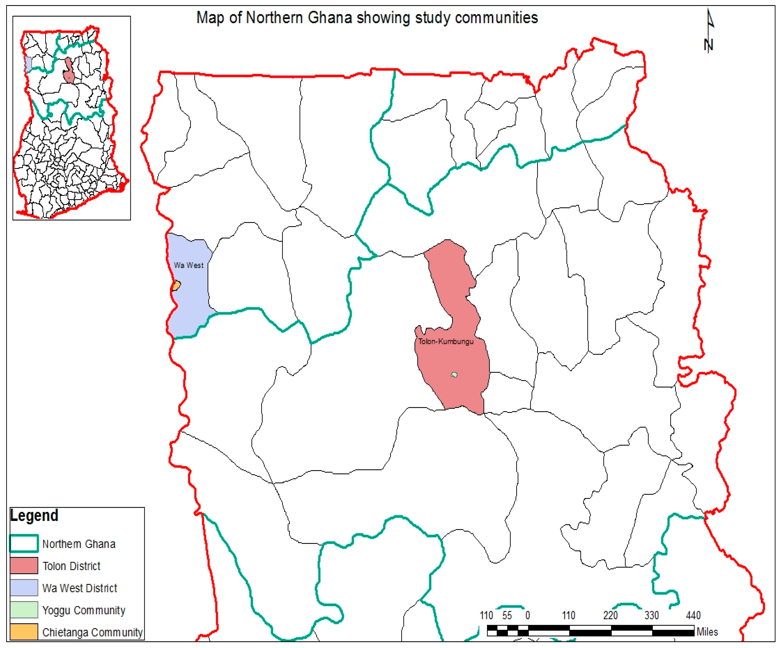
2.1. Study Area

Northern Ghana is made up of three administrative regions, that is, the Northern, the Upper West, and the Upper East Regions, which occupy approximately 41% of Ghana’s total land area [25]. These regions lie within the Sudan-Savanna agroecological zones of Ghana; owing to their semiarid climate and physical conditions, these regions are highly vulnerable to climate and ecosystem changes [6]. Most of the inhabitants of Northern Ghana that live in rural areas rely on local ecosystems for their livelihoods. Rain-fed agriculture and livestock rearing are the main occupations of the populations in these regions [26].
In this study, two rural communities—Chietanga in Wa West District of the Upper West Region and Yoggu in Tolon District of the Northern Region (Figure 1)—were selected principally for their proneness and vulnerability to extreme weather events, such as floods and droughts [23]. These two communities are greatly impacted by Harmattan dry winds [6] and are both prone to droughts. Because of their short rainy seasons, both communities have only one cropping season. Chietanga is located close to the Black Volta River and faces frequent floods during the rainy season and during the spillage of the Bagre Dam in neighboring Burkina Faso. Table 1 presents key characteristics of Chietanga and Yoggu. Both of the communities also experience other, less frequent, disaster events, including bushfires, strong winds, and agricultural pests and diseases.

2.2. Field Data Collection Process and Methods

Participatory Rural Appraisal (PRA) methods, which are a set of participatory and visual techniques for assessing group and community resources, identifying and prioritizing problems, and appraising strategies for solving them [28], were employed as an interactive data collection approach in order to learn multiple perspectives existing in the communities. The use of PRA also enabled communities and target groups to lead in evaluating their views and situations [29]. Key informant interviews, household surveys, and focus group discussions in both of the communities were used for primary data collection of traditional knowledge and practices that are used to manage disaster events in the studied area.
Two field visits were made in this study. A preliminary field survey was completed from February to March 2016. This visit was geared at carrying out key informant interviews and focus group discussions in both communities. Key informants in this study were made up of members of traditional councils (a council of community leaders usually headed by a chief), other traditional institutions (local associations or groups whose membership is subject to certain traditional obligations), and traditional knowledge holders. A household questionnaire was developed using data obtaining from this preliminary visit, which was cross-validated against households’ data gathered during the final field visit in October to November 2016. Specifically, validation of data by households was articulated around three major aspects: awareness, compliance or usage, and perceived effectiveness of traditional and local practices, as reported by key informants within and outside the community.

2.2.1. Key Informant Interviews

Key informants were selected using a convenience sampling approach after initial community entry meetings in both communities. Thirty-four key informant interviews were carried out with all of them (Yoggu = 17, Chietanga = 17). Informants were 35 years of age or above and have lived in the communities for at least 20 years. In total, two chiefs (one from each community), 20 land owners (Tindanas) (10 from each community), four women leaders (Magazia) (two from each community), two assembly men (one from each community), two youth leaders (one from each community), four fetish priests or diviners/healers (two from each community), and an official from NADMO and the Centre for Indigenous Knowledge and Organizational Development were interviewed. Interviews were completed using semistructured questionnaires. Discussions were focused on disaster types, traditional disaster prediction mechanisms, and traditional and local disaster coping strategies. A local research assistant interpreted the local dialects, Dagomba or Waala, to English and vice versa to facilitate the discussions.

2.2.2. Focus Group Discussions

Following the key informant interviews, four focus group meetings were held for a broader corroboration of information obtained from key informants (Yoggu = 40, Chietanga = 35). Discussions revolved around key topics identified in the informant interviews. Participation of representatives from all strata of the community (especially female heads of households) was a priority in selecting participants. There were 15–17 participants per focus group meeting. These participants were selected by the community council members during community entry meetings on the basis of different occupations within the community. Separate focus group meetings were held for men and women in order in order to determine gender-sensitive practices and constraints to DRR practices.
Information (from reflexive and field notes) and questionnaires were analyzed by categorization. This was mostly done through coding (construction of themes) by grouping the interviewees’ responses into categories to bring out similarities and differences. The corroborated data from key informant interviews and focus group discussions were used to develop a household questionnaire.

2.2.3. Household Questionnaire surveys

Household questionnaires survey was designed to measure or assess the perceived severity of disaster events, as well as the awareness, usage, or compliance levels, and the perceived effectiveness of the traditional and local disaster prediction and coping mechanisms. A total of 75 face-to-face interviews (Chietanga = 35, Yoggu = 40) were conducted with household heads in the two study communities. In cases where the household heads were not available for the interview, the next of kin (determined by other members of the household) was interviewed. The minimum number of samples from each community for household questionnaire survey was collected. Regarding the minimum number of samples, we relied on Wheater and Cook [30] in which they stated that as a rule of thumb, the minimum number that can be analysed effectively is about 30 for each subgroup surveyed.
A convenient sampling (also known as availability sampling) approach was employed. Convenient sampling is a type of nonprobability sampling where members of the target population that meet certain practical criteria, such as availability at a given time, geographical proximity, easy accessibility, or the willingness to participate are included for the purpose of the study [31]. Although this sampling approach poses the risk of selection bias, it is generally speedy, inexpensive and less labour intensive compared to other sampling methods as participants are readily available. Thus, it was found to be cost-effective for this study.
Drawing on the unidimensional Likert scaling method, households w0ere also asked to rank on a scale of 1 to 5 (1 = fairly negative; 2 = moderately negative; 3 = negative; 4 = highly negative; 5 = extremely negative) their perception of how the different disaster events adversely affected their livelihoods.

3. Results

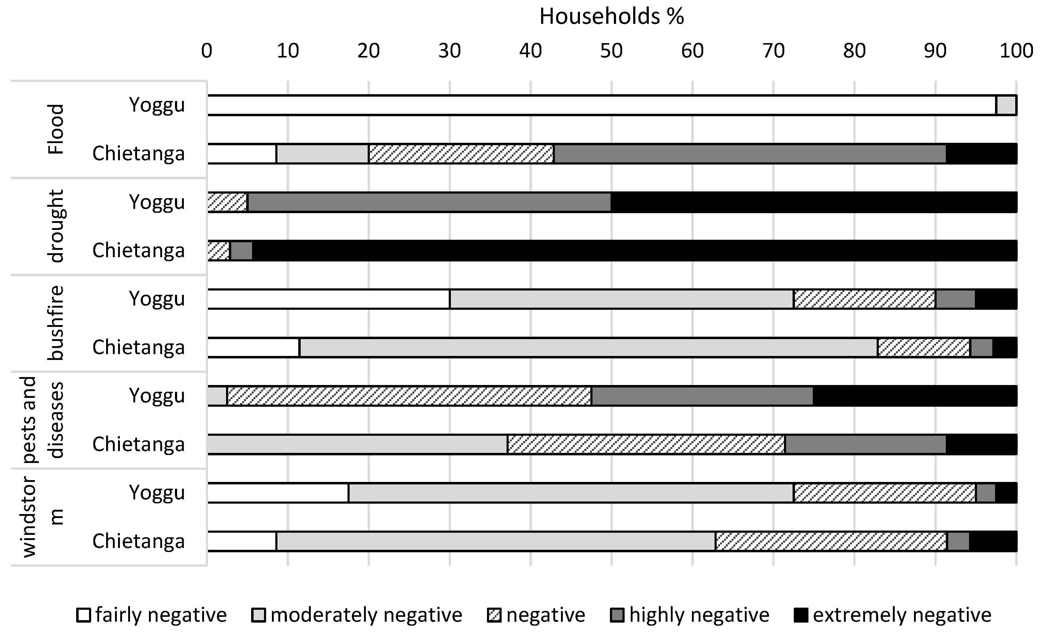
3.1. Negative Effects of Principal Disaster Events in Study Communities

Analysis of preliminary field survey data coupled with secondary information highlighted five principal disaster events—that is, floods, droughts, pests and diseases, bushfires, and windstorms—as influential on the livelihood systems and ecosystem health of the study area. Households were asked about their perception of the negative effects of the identified disaster events on their daily and seasonal lives. Results from the ranking in the two study communities are illustrated in Figure 2. From Figure 2 the overwhelming majority (97.5%) of households in Yoggu perceived flood to have a fairly negative impact on livelihood systems. In Chietanga, the effect of flood on the households was considered to be highly negative. Regarding drought as a disastrous event, the majority of households from both sites viewed it as extremely negative (i.e., Yoggu: 50%, Chietanga: 94.3%). Bushfires were perceived by most respondents to have a moderately negative effect on the households in Yoggu (42.5%) and Chietanga (71.4%). Pests and diseases were perceived as negative by the majority of respondents (45%) in Yoggu, whereas the majority (37.1%) in Chietanga considered it to be moderately negative. Windstorms, according to the majority of households in Yoggu (55.5%) and Chietanga (54.3%), were considered to be a moderately negative disaster event.
The study participants believed that droughts cause low yields in the community by reducing the soil’s moisture content and delaying the planting season. It was acknowledged that floods wash away crops in farms, submerge farms and grazing lands, and make fuelwood unavailable to villagers. Pests and diseases were connected to reduced crop yields, as well as affecting the mobility of animals in the case of animal pests. Furthermore, bushfires were recognized as a threat to farms and grazing lands, in addition to medicinal plants and other important ecosystems, whereas the destruction of rooftops and the uprooting of trees in farms and around the village were attributed to windstorms.

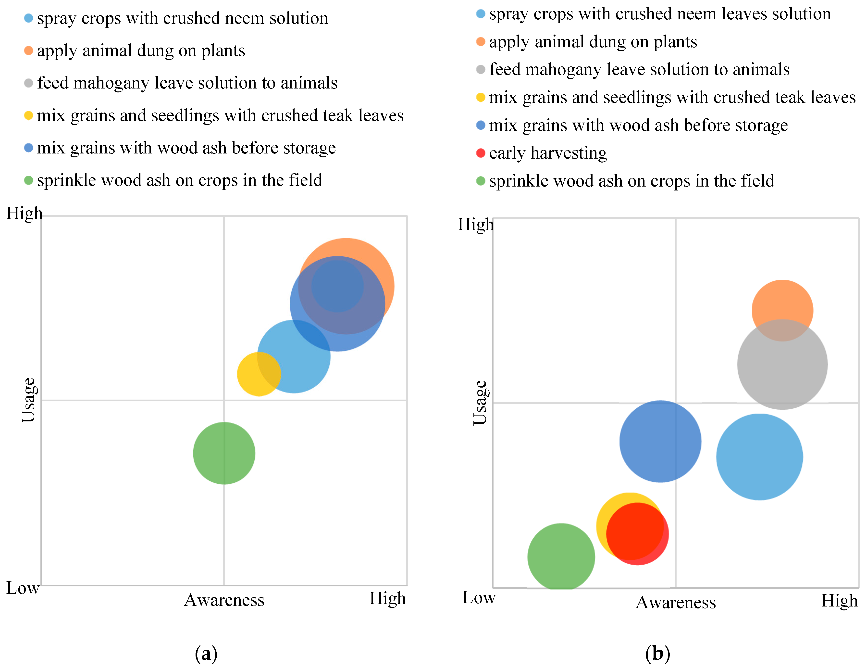
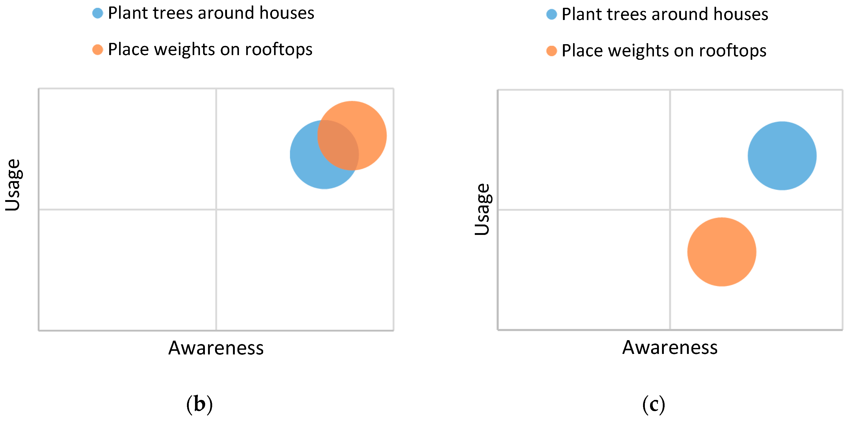
3.2. Traditional and Local Knowledge and Practices for Disaster Management

3.2.1. Disaster Prediction Practices

Effective management of disaster events contributes to minimizing vulnerability and enhancing the resilience in communities and households. Our survey results showed that the communities of Chietanga and Yoggu have no scientific resources to predict disasters and that they rely on traditional and local knowledge and practices developed over generations to forecast possible occurrences and the magnitude of disaster events. These practices are enshrined in the local way of life and are drawn from spiritual beliefs and observations spanning several years of living in adverse hydrometeorological conditions. Only droughts and floods could be predicted by communities.
(a) Drought-Prediction Knowledge and Practices
Households in the study area employ diverse traditional and local knowledge and practices to predict drought events. Table 2 presents the indicators used to predict droughts in the study area. The “snails and chameleon egg hatch” indicator can be typified as a practice/knowledge based on spiritual beliefs. It refers to knowledge associated with mythical and cosmological ideologies. The other forms of knowledge/practices are based on observations, that is, those that are based on experience, tested over several generations of use, and adapted to local environments.
(b) Flood Prediction Practices
The White Volta River inhabits a small population of hippopotamuses that breed and feed along the shores of the river in Chietanga. The animals spend most of their time in or very close to the river and rarely venture inland, except during floods or when a flood is anticipated. The key informants revealed that the hippopotamuses always move inland several hours before a flood. This happens for floods caused by heavy rainfall, as well as floods that are caused by the spillage of the Bagre Dam. Locals are immediately alerted to the possibility of a flood if they discover fresh hippopotamus fecal matter or if they observed the animals’ movement inland. In an area where access to timely information from official sources about potential disaster events is limited due to the area’s enclaved nature and poverty, these observations serve as valuable flood indicators.

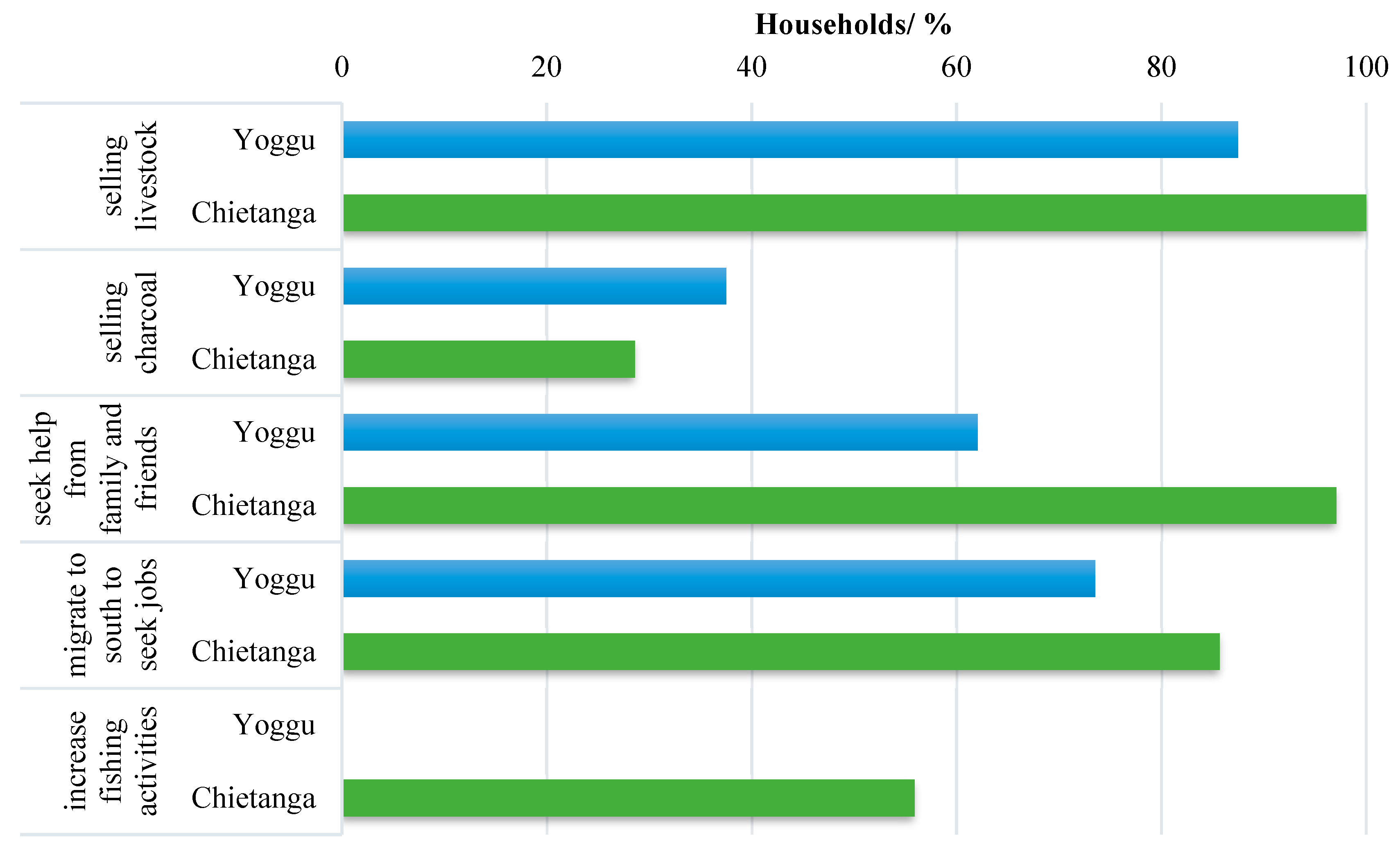
3.2.2. Disaster Coping Practices

(a) Drought Coping Practices: Awareness, Usage, and Perceived Effectiveness
Among the identified coping practices, the household questionnaires showed that all of the respondents in both communities are aware of the application of cattle dung on fields to mitigate the effects of drought (Figure 3). Regarding the perceived effectiveness of drought coping practices, the practice of applying cattle dung on fields was considered to be effective by 73.3% of the respondents in Yoggu and by 81.1% in Chietanga (Figure 3). Similarly, we noted high awareness and perceived effectiveness for the “use of drought-adapted seedlings” in both communities, but the usage level was very low. Respondents complained about the high cost of these drought-adapted seedlings and about the insufficient quantity of seedlings that are distributed free of charge by the agents of the Ministry of Food and Agriculture (MoFA). High general awareness and usage levels were found in all the other drought coping practices in both communities; however, the perceived effectiveness varied among the different practices (Figure 3).
The key informant interviews and participant observations showed that communities allow for cattle to feed and sleep in fields before the planting season. This is done to permit cattle dung (droppings) to be deposited on the fields. The fields are later plowed before planting to enable mixing of the cattle dung with the soil. This increases the fertility of the soil and is considered to be a substitute to inorganic fertilizers. It also gives crops a form of resilience during drought periods, speeding up maturity and increasing resistance to short droughts. When droughts are predicted in Yoggu, farms are weeded to prevent competition for moisture between the crop and unwanted weeds during a dry period. However, farms in Chietanga are not weeded when droughts are predicted because the farmers believe that weeding exposes the plants and soil to heat, and thus the available moisture evaporates. Local communities in both districts also make soil heaps around crops to preserve the available moisture for the crops and provide the crops with stamina. To mitigate drought effects, farmers avoid planting early in the wet period. They wait until almost the middle of the rainy season before planting to elude droughts. In addition, in cases where drought occurs later in the season, this ensures that the soil will be sufficiently moist to enable the maturity of existing crops. In Yoggu, there are dugouts within the community to trap the freshwater that is used by locals and livestock during the dry season. To mitigate the effects of droughts on these dugouts, local people avoid cutting trees around dugouts, even during the driest periods of the year when fuelwood becomes very scarce.
(b) Flood Coping Practices: Awareness, Usage, and Perceived Effectiveness
In Chietanga, 82.9% of the respondents were aware of the practice of building flood barriers around farms to mitigate floods, and 68.6% of these respondents use this method to mitigate the effects of flooding (Figure 4). Despite the higher awareness and the usage of all three identified flood mitigation practices, their perceived effectiveness is generally low (41.7% for flood barriers, 12.9% for water channels, and 17.9% for mud heaps around crops).
To mitigate the impacts of floods, Chietanga’s residents build flood barriers made from mud around their farms to prevent water from flooding their crops. Floodwater usually submerges all crops, particularly in farms that are near the river. The fate of these crops generally depends on the flood’s duration. Residents also create water channels in their farms to allow floodwater to circulate without washing away crops. Mud heaps are made around mature crops to prevent crops from being washed away.
(c) Pest and Disease Coping Practices: Awareness, Usage, and Perceived Effectiveness
Several different types of pests and diseases affect crops in the study area. The lack of science-based pest control mechanisms means that residents of the study area turn to traditional methods to secure crop yields. Table 3 shows the most common pests and diseases that occur in the study sites.
In the case of pests and diseases that were affecting plants, study results show that the residents of Yoggu and Chietanga crush the leaves of neem trees (Azadirachta indica) and mix them with water. This solution serves as an insecticide, which is applied to crops. Crushed neem leaves are also used to store grains and are mixed with grains before storage to prevent insects and bacteria from attacking the grains. Grains that are generally stored in this way include maize, cowpea, and Bambara beans. Additionally, communities mix seedlings with crushed teak (Tectona grandis) leaves before planting. The resin of the teak has an oil that is highly water-resistant, which protects the teak from decay and insects and bacteria attacks. Wood ash from the kitchens is also often mixed with grains before storage to prevent insects from eating the grains. To scare away insects and birds from farms, it is common among residents to rub or sprinkle fresh animal (cattle and sheep) dung on crops and in farms. In cases of a disease outbreak on livestock, residents feed animals with mahogany leaves and bark.
In Yoggu, 87.5% of the respondents were aware of the practice of using crushed neem leaves to prevent insects and bacteria attacks, but only 42.5% applied this practice. Similarly, in Chietanga, up to 82.9% of the respondents were aware of this practice, but only 74.3% used it (Figure 5).
The perceived effectiveness of the different practices to adapt to pests and diseases varied within and between the communities. The effectiveness of the resin from teak leaves in preventing insects and bacteria attacks on seedlings and grains was acknowledged by only 16.7% of the respondents in Chietanga, whereas 50% of the respondents in Yoggu believed that the resin from teak leaves is effective in preserving seedlings and grains (Figure 5). The perceived effectiveness of the different coping practices varied depending on the communities, although usage and awareness levels were generally higher in Chietanga when compared to Yoggu. For instance, the practice of “mixing grains and seedlings with crushed teak leaves” had higher awareness and usage levels in Chietanga, but the perceived effectiveness was higher in Yoggu.
(d) Bushfire Coping Practices: Awareness, Usage, and Perceived Effectiveness
Key informants commented that they created fire belts around their farms in order to prevent bushfires from traversing into local farms. These belts were constructed by completely clearing the vegetation around farms to disconnect the vegetation in the farms from that out of the farms.
The household survey showed that 62.5% of the respondents in Yoggu were aware of the creation of fire belts as a mitigation strategy against bushfires, but only 25% of the respondents in Yoggu implemented it in their farms. Household survey participants claimed that creating fire belts is labor-intensive and time-consuming, hence the low level of their implementation. In Chietanga, all of the household respondents were aware of this practice, but only 65.7% of them created fire belts around their farms.
All of the household respondents in Yoggu believed that fire belts are effective in mitigating bushfires. However, the perceived effectiveness in Chietanga was not unanimous among the respondents, with 87% of those who practice this strategy believing it to be effective. A study by Jasaw et al. [32] on the adoption of mucuna pruriens as a land conservation strategy in northern Ghana provides empirical evidence on the usefulness of this practice to households in the study area.
(e) Windstorm Coping Practices: Awareness, Usage, and Perceived Effectiveness
Despite measures being inventoried in the area by this study, not all residents were aware of or used such measures to cope with windstorms. In Yoggu, 82.5% of the respondents were aware that trees around the village are used to mitigate windstorm effects (Figure 6). Likewise, in Chietanga, 80% of the respondents were involved in tree planting around homes to mitigate the effects of strong winds (figure 6). The household interview results showed a high perception of effectiveness to the different windstorm coping practices. In Chietanga and Yoggu, 90.3% and 69.2% of the respondents, respectively, considered that the placement of weights on rooftops was effective against windstorms. The coned-shape structure of many houses in Yoggu was responsible for the lower usage levels and perceived effectiveness.
Key informants of the study indicated that windstorms have become pertinent in Yoggu and Chietanga with varying consequences on livelihoods. Soil erosion and damage to rooftops are the principal consequences of windstorms; therefore, the residents resorted to planting small patches of plantations around their villages to counter such effects. Many also placed weights on their rooftops to prevent them from being destroyed by strong winds. The majority of respondents perceive these practices as effective.
(f) Other Disaster Response Measures
In Chietanga, household questionnaire results showed that all of the households sampled sell livestock as a coping mechanism when yields are low due to disasters, to be able to provide food for the family (Figure 7). Fishing activities also intensified during disaster periods in the study area, with 55.9% of the respondents attesting to intensifying their fishing activities during disaster periods. It was also common for residents to obtain financial and material help from friends and family during such periods. This was the case for 97.1% of the households. In Yoggu, 87.5% of the households sold their livestock during disaster periods to fend for their families. Charcoal production for commercialization was also common in 37.5% of the households that are involved in this activity.
Local farmers planted different varieties of crops on the same piece of land, thereby increasing the chances of better harvest and livelihood security. There was also a gradual shift to crops that were more resistant to droughts but were not previously cultivated in the area. As such, there was a gradual shift toward crops like cassava, sorghum, tobacco, and pepper, which are considered to be much more resistant to drought by the key informants of this study. In Chietanga, vegetable and fruit growers are increasing in number and are gradually shifting toward the White Volta River where they can use water pumps provided by the MoFA. These pumps can feed much-needed water to crops during even the driest periods of the year, which is locally referred to as “dry season farming”.

4. Discussion

4.1. Disasters and Their Effects on Local Livelihood

Droughts were the most dreaded climate extreme in the study area. Respondents in Yoggu and Chietanga rated drought as having the greatest effect on local livelihood. Residents believed that they experience drought at least twice a year and that it was the main reason for low yields that were experienced by local farmers. Water shortages leading to health problems for both humans and livestock were also recurrent causes of yearly droughts experienced in the area. Women and children were the most affected in those situations. Rademacher-Schulz and Mahama [33] (p. 22) reported that “long droughts in Northern Ghana including the Great Sahelian droughts of the late 1970s and 1980s led to dwindling incomes and food insecurity, with farmers, pastoralists, women, and children being the most affected groups”.
Floods predominantly occurred in Chietanga, mainly because of the close proximity (sharing borders) of the White Volta River to the south. After a heavy downpour, it is common for the White Volta River to overflow its banks and flush out crops on farms along the river. The study results showed that the most recent floods affected more than 25% of the population in Chietanga. This had severe consequences on food security in the community because the local economy depends on agricultural products. A study in 2013 showed that torrential rains caused 25% of floods in Northern Ghana, whereas 75% were caused by the spillage of the Bagre Dam [34].
Our interviews revealed that no forms of science-based measures exist in order to predict and control agricultural pests and diseases in the study area because of the lack of technical and financial capabilities. Consequently, traditional practices were often applied when the diseases and pests produced visible effects, although it was often too late. Leaf defoliation was generally the most common sign of disease presence, but it was also contradicted with crop maturation. Local farmers in Yoggu and Chietanga could not quantify crop yield losses due to pests and diseases, but the generally accepted idea was that the wetter the season was, the more the pests and diseases prevailed, consequently reducing crop yields. This is consistent with an assessment that was carried out in 2002, which established that yield loss due to pests and diseases in Northern Ghana was closer to 100% in extremely wet years, with a yield reduction of 28–50% in years with moderate rainfall [35]. Studies by Mauchline et al. [36] and Verma et al. [37] exploring the role of termites and their impact on crop yields in tropical ecosystems found the widespread use of teak resin by locals, who considered it to be the most practical and cost-effective form of pest control. With the same strategy being used in the study area, formal agriculture advisory agents need to collaborate with local farmers to explore opportunities for upscaling this traditional practice.

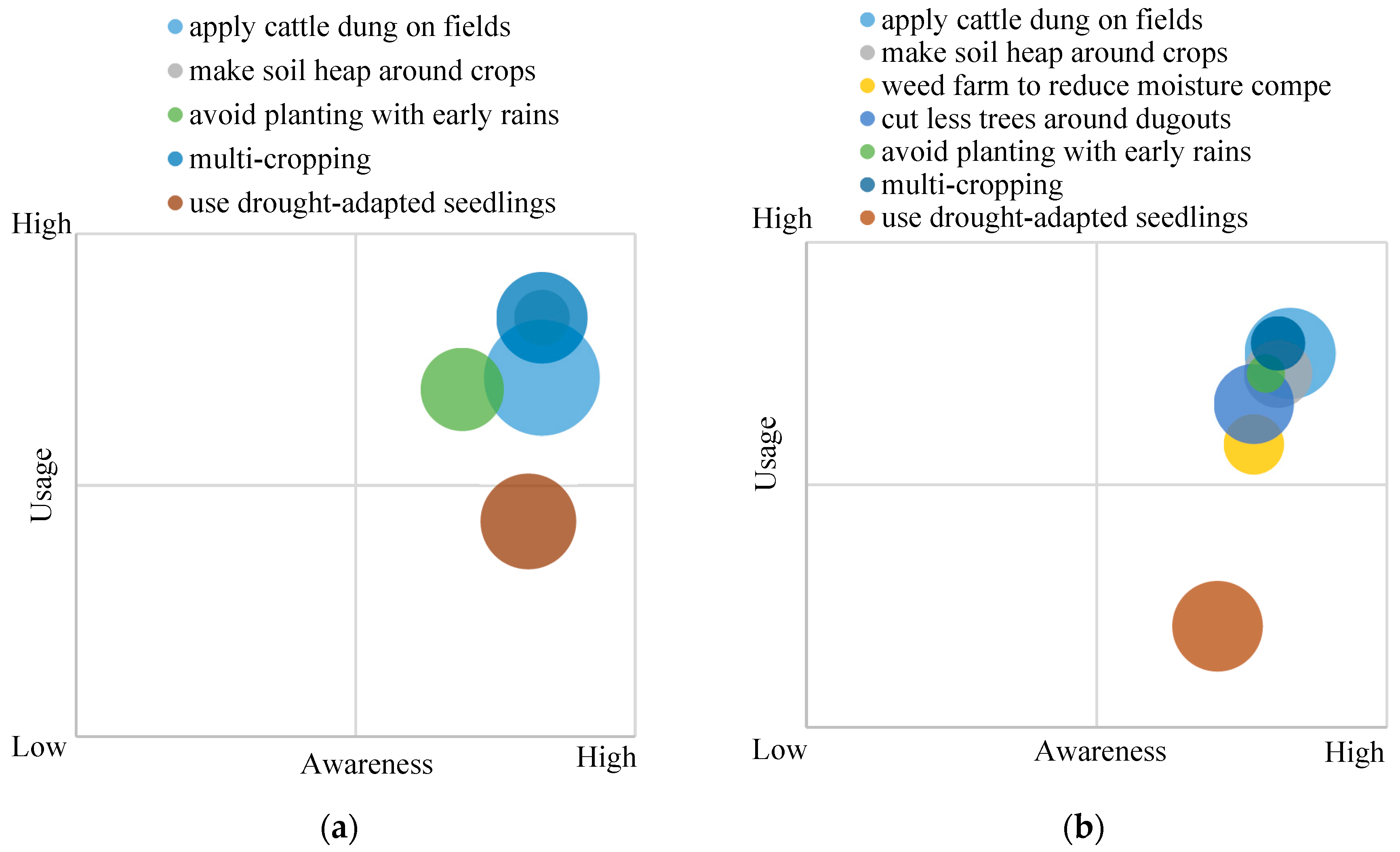
4.2. Disaster Coping Practices and Their Levels of Application

Several coping practices were identified in the study, including the application of cattle dung on fields to mitigate drought effects, the application of animal dung on plants to reduce the effects of pests and diseases, the creation of fire belts around farms to mitigate bushfires, and the placement of weights on rooftops to prevent destruction during windstorms.
Mixed cropping in bush fallow systems was adopted in the study area to increase the likelihood of improved harvest. This is consistent with the findings of Gyasi [38], who reported that migratory systems of farming in Northern Ghana have introduced more sedentary bush fallow systems. These involve the intercropping of crops like guinea corn, millet, yam, and other crops to minimize the effects of soil erosion and improve food security. Some residents in Chietanga also practice dry season vegetable farming close to the White Volta River using water pumps. However, most farmers have abandoned such dry season farms because of the high cost of fueling the water pump generator. Dry season farming has been found to be valuable in providing extra income and sustaining food security of smallholder farmers in most communities in Northern Ghana [39] but sustaining it will need government interventions especially in the construction of irrigation facilities.
The pastoralist sector is also an important contributor to drought adaptation as it provides much-needed income to buy drought-adapted seedlings and is also an important protein and livelihood source, particularly during periods of low crop yields. This is consistent with the conclusions from an investigation on drought mitigation in the Moyale District of Kenya that was conducted by Erasmus et al. [40]. They established that local pastoralists developed hide and skin trade and dry season farming (which enabled the production of onions, tomatoes, and kale) to diversify their source of livelihood and prepare for drought events. This led to a partnership with the Department of Crop Production in the Ministry of Agriculture of Kenya for the installation and provision of technical capacity to a community-managed irrigation scheme [40]. Initiating such hide and skin trade and dryland farming in Northern Ghana, with the financial and technical support from MoFA, may go a long way to diversify the livelihoods of local communities, and thus help them to cope easily with droughts.
Traditional taboos, forbidding residents from cutting trees around dugouts or secret grooves, equally contribute to reducing drought impacts in the study area, specifically in Yoggu. Traditional taboos have led to similar success in the Offin River Basin in Ghana, where days when people are forbidden from the river to enable the river gods to have a day of rest served as a means of protecting water bodies in the Offin River Basin [41]. However, the results show that the perceived effectiveness of these coping strategies is very low. Awareness levels also do not equate to the usage of these practices. This is consistent with the results of Boafo et al. [23]. Boafo et al. [23] reported a variation between the awareness and the compliance of traditional ecological knowledge (TEK) in ecosystem management by households in other regions in Northern Ghana, and they called into question the usefulness of some TEKs for local communities.

4.3. Options for Integrating Traditional and Local Practices into Science-Based DRR Efforts

The effectiveness and applicability of the traditional and local practices identified in this study can be enhanced by build-in innovations based on modern science. The following are some examples:
  • The farming system in the study communities is rain-fed, and, as such, planting depends on the rainy season. However, climate variability has made traditional weather forecasting practices less effective, which has reduced the effectiveness of drought mitigation efforts. Improving drought-prediction practices is an urgent priority in these cases, and the introduction of weather forecasting systems could be an effective approach to address the issue. Other structural measures, such as improving the retention capacities of storage dugouts by creating channels that lead stagnant rainwaters to discharge into the water retention dugouts, are necessary. On a more social basis, the availability of drought-adapted seedlings (often provided by the MoFA) can be increased if communities unite to enhance their financial power to purchase such seedlings.
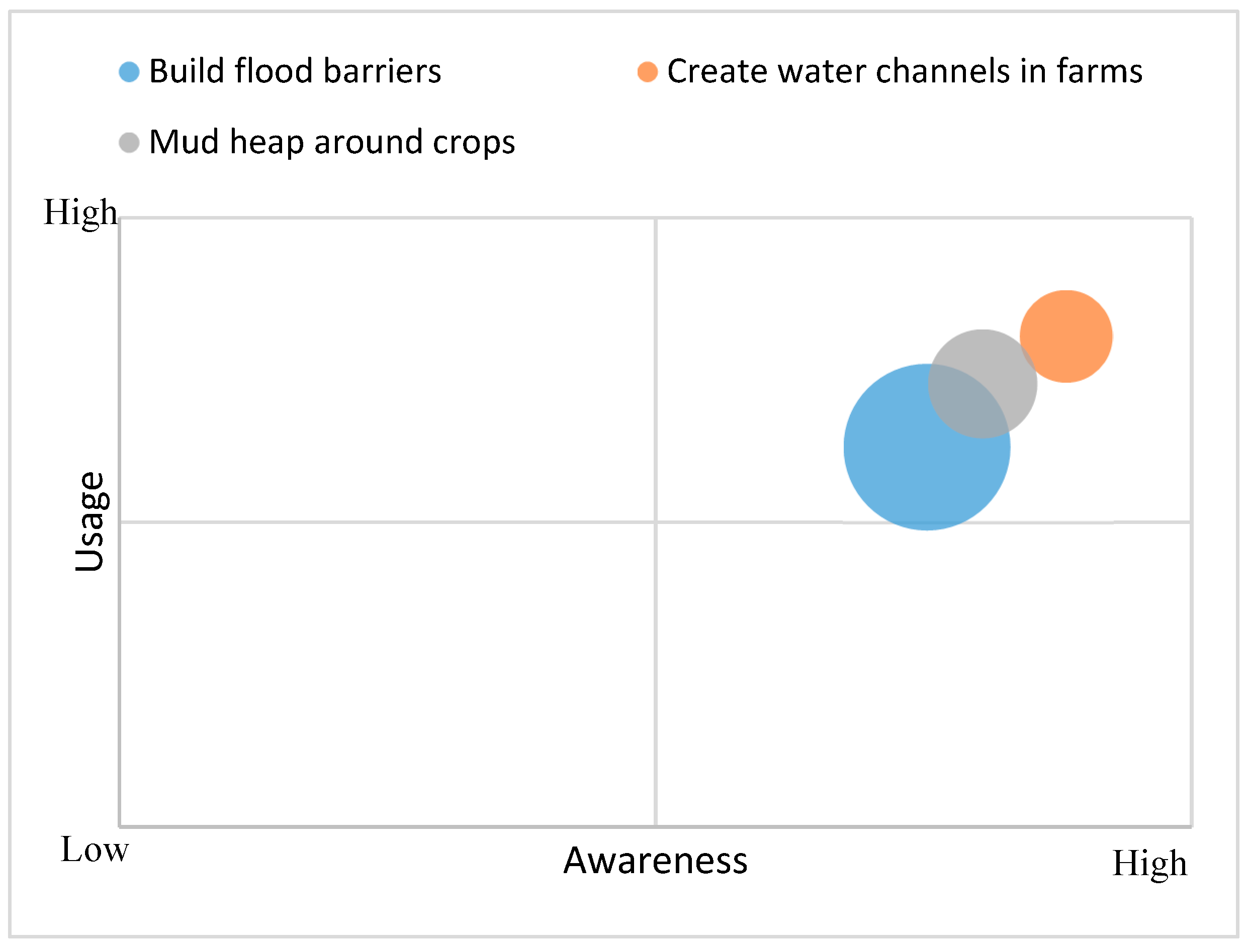
  • In order to mitigate the effects of floods, respondents in the study area created water channels and built flood barriers. These mitigation efforts can be augmented by semi structural measures, including water storage reservoirs and flood retardation ponds. Such measures will lead to water retention and storage (ensuring water availability during dry periods and thus preventing droughts) and discharge at times of flood. Water storage reservoirs and flood retardation ponds can be manually dug out by community members; however, engineering assistance may be required for zoning to delineate floodplains. Farmers can subsequently rely on their own resources to manage water from cheap technological innovations [42]. Other actions, such as forecasting, early warning, other household preparedness activities, and post-flood recovery operations should also be used concurrently. Such an integrated system (including the semi structural and social measures) should significantly improve flood mitigation in the study area.
  • Agroforestry practices of introducing trees among crops can improve resilience to windstorms, which protects crops as well as rooftops. Indigenous trees with minor effects on groundwater content can be used in these agroforestry systems. In addition, trees that can add value to local livelihoods (e.g., fruit trees, such as mangoes) should be considered. Campbell et al. [43] studied traditional agroforestry systems in Zimbabwe. They showed that such systems will increase farms’ productivity because of fodder availability and the importance of cattle in the farming system. Agroforestry can also contribute to drought mitigation. Planting trees along with crops around water retention dugouts will reduce evaporation and thus avert the drying-out of dugouts during the dry seasons.
  • Communities organizing themselves into small social groups and associations will facilitate the purchase of pesticides and other crop disease control products. This can be associated with existing traditional practices (e.g., the practices of mixing grains and seedlings with crushed teak leaves) and can improve their capacities to fight against pests and diseases through such practices. For instance, by exploiting crushed teak leaves as pesticides, communities can take advantage of a resin that is found in teak that protects the plant from pests and diseases. This knowledge can be enhanced by developing local capacities in the sustainable extraction of this resin from the teak plant, improving storage conditions, and applying the resin (solution) to grains and seedlings.

5. Limitations of the Study

Our study aims to document and make preliminary evaluation of the existing traditional and local knowledge in enhancing the resilience of local communities against natural disasters by collecting both quantitative and qualitative data. However, our convenient (availability) sampling method for the questionnaire survey may have sampling bias, which cause either the over-representation of or under-representation of traditional and local knowledge and practices. As part of our future work, the sampling size will be expanded with stratified random sampling to overcome this limitation. In addition, it should be noted that our measurement of effectiveness of local and traditional knowledge and practices simply depends on perception of the respondent. Effectiveness of each local and traditional knowledge and practices should be further explored with empirical evidences.

6. Conclusions

Although modern scientific knowledge for DRR is invaluable, it is essential to recognize the role of traditional and local knowledge in enhancing the resilience of local communities. Lessons can be derived from the traditional and local practices that have been applied by communities over centuries to cope with disasters. However, in order to integrate these knowledge systems into disaster management strategies, they must be understood and scientifically evaluated [40]. This study inventoried droughts, floods, bushfires, windstorms, and pests and diseases as the major disaster events with impacts on local livelihoods in Northern Ghana.
Droughts, floods, and pests and diseases, according to our results, were the disaster events with the greatest recent negative effects. While traditional and local mechanisms exist to predict droughts and floods, such mechanisms failed to predict the prevalence of pests and diseases in this study. As for disaster coping mechanisms, although the traditional and local knowledge systems for DRR are well embedded in the study area, the residents of the study communities remain affected by different disaster events. This is mainly because these local practices have a low perceived effectiveness and low application levels (usage). A lack of resources is also a major obstacle to implementing some measures. For example, “applying cattle dung on fields” before planting is perceived as the most effective practice to cope with droughts, but the application itself is limited by the availability of cattle dung during the planting season. It is recommended that the communities develop dugouts to store (or pile) cattle dung during off seasons for later use. Additionally, the knowledge inventory of local practices can provide baseline information to integrate local practices with modern scientific knowledge on DRR.

Acknowledgments

This study was financially supported by the Japan International Cooperation Agency (JICA) and the Japan Science and Technology Agency (JST) under the framework of the international project “Enhancing Resilience to Climate and Ecosystem Changes in Semi-Arid Africa: An Integrated Approach (CECAR-Africa).” The study was also partially supported by “Food Security Impacts of Industrial Crop Expansion in Sub-Sahara Africa” (FICESSA) project funded by JST as well as JSPS KAKENHI Grant Number 16K13348. We would like to specially thank all the stakeholders of Yoggu and Chietanga and all those who made our field work in these communities a success, particularly Asani Abass and Alhassan Fuseini.

Author Contributions

Nsioh Macnight Ngwese, Yaw Agyeman Boafo, and Godfred Jasaw conceived and designed the study objectives and research questions. Nsioh Macnight Ngwese, Yaw Boafo, Akiko Sato, and Godfred Jasaw designed the data collection methodologies. Nsioh Macnight Ngwese collected and analyzed the data from focus groups, key informant, and household questionnaires. Osamu Saito supervised the entire study and edited the entire manuscript. All authors reviewed the final draft of the article before submission.

Conflicts of Interest

The authors declare no conflicts of interest.

References

  1. Armah, F.A.; Obiri, S.; Yawson, D.O.; Pappoe, A.N.M.; Akoto, B. Mining and heavy metal pollution: Assessment of aquatic environments in Tarkwa (Ghana) using multivariate statistical analysis. J. Environ. Stat. 2010, 1, 1–13. [Google Scholar]
  2. Environmental Protection Agency. Flood and Drought Risk Mapping in Ghana; EPA: Accra, Ghana, 2012.
  3. Environmental Protection Agency. National Action Programme to Combat Drought and Desertification; EPA: Accra, Ghana, 2010.
  4. National Disaster Management Organization. Flood Statistics for Buipe and Yapei, 2003–2010; NADMO: Buipe, Ghana, 2010.
  5. National Disaster Management Organisation. National Disaster Management Organisation. Annual Report 2011; National Disaster Management Organisation: Accra, Ghana, 2011.
  6. Boafo, Y.A.; Saito, O.; Jasaw, G.S.; Otsuki, K.; Takeuchi, K. Provisioning ecosystem services-sharing as a coping and adaptation strategy among rural communities in Ghana’s semi-arid ecosystem. Ecosyst. Serv. 2016, 19, 92–102. [Google Scholar] [CrossRef]
  7. United Nations Development Programme (UNDP). Project Facts—Ghana. Enhancing National Strategies for Effective Disaster Risk Reduction in Ghana; UNDP: Accra, Ghana, 2010. [Google Scholar]
  8. Otsuki, K.; Jasaw, G.S.; Lolig, V. Framing community resilience through mobility and gender. J. Disaster Res. 2014, 9, 554–562. [Google Scholar] [CrossRef]
  9. Kranjac-Berisavljevic, G.; Abdul-Ghanyu, S.; Gandaa, B.Z.; Abagale, F.K. Dry spells occurrence in Tamale, Northern Ghana—Review of available information. J. Disaster Res. 2014, 9, 468–474. [Google Scholar] [CrossRef]
  10. Lolig, V.; Donkoh, S.A.; Obeng, F.K.; Ansah, I.G.K.; Jasaw, G.S.; Kusakari, Y.; Asubonteng, K.O.; Gandaa, B.; Dayour, F.; Dzivenu, T.; et al. Household coping strategies in drought and flood-prone communities in Northern Ghana. J. Disaster Res. 2014, 9, 542–553. [Google Scholar] [CrossRef]
  11. World Intellectual Property Organization (WIPO). Traditional knowledge. Available online: http://www.wipo.int/tk/en/tk/ (accessed 10 April 2017).
  12. United Nations International Strategy for Disaster Reduction (UNISDR). Terminology on Disaster Risk Reduction; UNISDR: Geneva, Switzerland, 2009. [Google Scholar]
  13. Reyes-Garcia, V. The relevance of traditional knowledge systems for ethnopharmacological research: Theoretical and methodology contributions. J. Ethnobiol. Ethnomed. 2010. [Google Scholar] [CrossRef] [PubMed] [Green Version]
  14. Saylor, C.R.; Alsharif, K.A.; Torres, H. The importance of traditional ecological knowledge in agroecological systems in Peru. Int. J. Biodivers. Sci. Ecosyst. Serv. Manag. 2017, 13, 150–161. [Google Scholar] [CrossRef]
  15. Berkes, F.; Colding, J.; Folke, C. Rediscovery of traditional ecological knowledge as adaptive management. Ecol. Appl. 2000, 10, 1251–1262. [Google Scholar] [CrossRef]
  16. Abayie-Boateng, A. Traditional conservation practices: Ghana’s example. Res. Rev. Inst. Afr. Stud. 1998, 14, 42–51. [Google Scholar]
  17. Getz, W.M.; Fortmann, L.; Cumming, D.; du Toit, J.; Hilty, J.; Martin, R.; Murphree, M.; Owen-Smith, N.; Starfield, A.M.; Westphal, M.I. Sustaining natural and human capital: Villagers and scientists. Science 1999, 283, 1855–1856. [Google Scholar] [CrossRef]
  18. Coppolillo, P.B. The Landscape Ecology of Pastoral Herding: Spatial Analysis of Land Use and Livestock Production in East Africa. Hum. Ecol. 2000, 28, 527–560. [Google Scholar] [CrossRef]
  19. Pandey, D.N. Sacred water and sanctified vegetation: Tanks and trees in India. In Proceedings of the Conference of the International Association for the Study of Common Property, Bloomington, IN, USA, 31 May–4 June 2000. [Google Scholar]
  20. Byers, B.A.; Cunliffe, R.N.; Hudak, A.T. Linking the conservation of culture and nature: A case study of sacred forests in Zimbabwe. Hum. Ecol. 2001, 29, 187–218. [Google Scholar] [CrossRef]
  21. Dekens, J. Local Knowledge for Disaster Preparedness: A Literature Review; International Centre for Integrated Mountain Development: Kathmandu, Nepal, 2007. [Google Scholar]
  22. Tiwari, B.K.; Barik, S.K.; Tripathi, R.S. Biodiversity value, status, and strategies for conservation of sacred groves of Meghalaya, India. Ecosyst. Health 1998, 4, 20–32. [Google Scholar] [CrossRef]
  23. Boafo, Y.A.; Saito, O.; Kato, S.; Kamiyama, C.; Takeuchi, K.; Nakahara, M. The role of traditional ecological knowledge in ecosystem services management: The case of four rural communities in Northern Ghana. Int. J. Biodivers. Sci. Ecosyst. Serv. Manag 2015, 12, 24–38. [Google Scholar] [CrossRef]
  24. Geis, D.E. By design: The disaster resistant and quality-of-life community. Nat. Hazards Rev. 2000, 1, 151–160. [Google Scholar] [CrossRef]
  25. Bonye, S.Z.; Jasaw, S.G. Traditional coping mechanisms in disaster management in the Builsa and Sissala Districts of Northern Ghana. Eur. J. Soc. Sci. 2011, 25, 1–15. [Google Scholar]
  26. Apronti, P.T.; Saito, O.; Otsuki, K.; Kranjac-Berisavljevic, G. Education for disaster risk reduction: Linking theory and practice in Ghana’s basic schools. Sustainability 2015, 7, 9160–9186. [Google Scholar] [CrossRef]
  27. Antwi, E.K.; Otsuki, K.; Osamu, S.; Obeng, F.K.; Gyekye, K.A.; Boakye-Danquah, J.; Boafo, Y.A.; Kusakari, Y.; Yiran, G.A.B.; Owusu, A.B. Developing a community-based resilience assessment model with reference to Northern Ghana. J. Integr. Disaster Manag. 2014, 4, 73–92. [Google Scholar] [CrossRef]
  28. Mukherjee, A. Participatory Rural Appraisal. Methods and applications in rural planning; VIKAS Publishing House PVT LTD: Delhi, India, 1995. [Google Scholar]
  29. Boafo, Y.A.; Saito, O.; Takeuchi, K. Provisioning ecosystem services in rural savanna landscapes of Northern Ghana: An assessment of supply, utilization, and drivers of change. J. Disaster Res. 2014, 9, 501–515. [Google Scholar] [CrossRef]
  30. Wheater, C.P.; Cook, P.A. Using Statistics to Understand the Environment; Routledge: New York, NY, USA, 2000. [Google Scholar]
  31. Etikan, I.; Musa, S.A.; Alkassim, R.S. Comparison of Convenience Sampling and Purposive Sampling. Am. J. Theor. Appl. Stat. 2016, 5, 1–4. [Google Scholar] [CrossRef]
  32. Jasaw, G.S.; Boafo, Y.A.; Lolig, V. Factors influencing the adoption of Mucuna Pruriens as a land conservation strategy. Evid. North. Ghana J. Sci. Technol. Environ. 2014, 4, 1–11. [Google Scholar]
  33. McCall, M.K. Application of participatory mapping and GIS using indigenous and local spatial knowledge. Disasters 2009, 36, 1–27. [Google Scholar]
  34. Campbell, B.M.; Clarke, J.M.; Gumbo, D.J. Traditional agroforestry practices in Zimbabwe. Agrofor Syst. 1991, 14, 99–111. [Google Scholar] [CrossRef]
  35. Baba, A.N.M.; Abayomi, O. Effects of Seasonal Floods on Households’ Livelihoods and Food Security in Tolon/Kumbumgu District of the Northern Region, Ghana. Am. J. Res. Commun. 2013, 1, 160–171. [Google Scholar]
  36. Mauchline, A.L.; Watson, S.J.; Brown, V.K.; Williams, R.J. Post-dispersal seed predation of non-target weeds in arable crops. Wees Res. 2005, 45, 157–164. [Google Scholar] [CrossRef]
  37. Verma, M.; Sharma, S.; Prasad, R. Biological alternatives for termite control: A review. Int. Biodeterior. Biodegrad. 2009, 63, 959–972. [Google Scholar] [CrossRef]
  38. Donkoh, S.; Kudadze, A.; Adzawla, W.; Ansah, J.G.K. Adoption of dry season vegetable farming and its effects on income at Golinga and Botanga irrigation sites, Northern Ghana. Ghana J. Sci. Technol. Dev. 2016, 4, 29–41. [Google Scholar]
  39. Rademacher-Schulz, C.; Mahama, E.S. “Where the rain falls” project case study: Ghana. Results from Nadowli District, Upper West Region. Report No 3; United Nations University Institute for Environment and Human Security (UNU-EHS): Bonn, Germany, 2012. [Google Scholar]
  40. Gyasi, E.A. Adaptation of Traditional Farming Systems to Environmental Stress in Ghana’s Upper East Region; Department of Geography and Resource Development: Accra, Ghana, 1993. [Google Scholar]
  41. Payen, J.; Faures, J.; Vallee, D. Small Reservoirs and Water Storage for Smallholder Farming; AG Water Solutions: Colombo, Sri Lanka, 2012. [Google Scholar]
  42. Erasmus, W.; Mpoke, L.; Yishak, Y. Mitigating the Impacts of Drought in Moyale District, Northern Kenya. Available online: https://odihpn.org/magazine/mitigating-the-impact-of-drought-in-moyale-district-northern-kenya/ (accessed on 16 April 2017).
  43. Gyampoh, B.A.; Idinoba, M.; Nkem, N.J. Using traditional knowledge to cope with climate change in rural Ghana. Development 2008, 51, 415–417. [Google Scholar] [CrossRef]
Figure 1. Map of Northern Ghana showing the study communities.
Sustainability 10 00825 g001
Figure 2. Households’ perceptions of adverse effects of disasters on livelihood.
Sustainability 10 00825 g002
Figure 3. Awareness, usage, and perceived effectiveness of drought coping practices in Chietanga (a) and Yoggu (b). The size of each bubble shows the level of perceived effectiveness.
Sustainability 10 00825 g003
Figure 4. Households’ awareness, usage, and effectiveness of flood coping practices in Chietanga. The size of each bubble shows the level of perceived effectiveness.
Sustainability 10 00825 g004
Figure 5. Awareness, usage, and perception of effectiveness of pests and diseases coping practices in Chietanga (a) and Yoggu (b). The size of the bubble shows the level of perceived effectiveness.
Sustainability 10 00825 g005
Figure 6. Households’ awareness, usage, and perceived effectiveness of windstorm coping practices in Chietanga (a) and Yoggu (b). The size of the bubble shows the level of perceived effectiveness.
Sustainability 10 00825 g006
Figure 7. Other disaster response measures.
Sustainability 10 00825 g007
Table 1. Key characteristics of the study communities as of 2016.
CharacteristicStudy Community
ChietangaYoggu
Estimated population5003314
Main ethnic groupsWaala, Dagaaba, BirifoDagomba
Main seasonal disasters experiencedFloods, droughtsDroughts
Estimated number of households37216
Main livelihood activitiesFarming, fishing, livestock rearing, food stuff, and livestock tradingFarming, livestock rearing, food stuff and livestock trading
Source: Adapted with data from Aponti et al. (2015) [26] and Antwi et al. (2014) [27].
Table 2. Traditional and local indicators to predict drought.
IndicatorDescriptionCommunity
Snails and chameleon egg hatchChameleons and snails always lay and hatch their eggs during dry periods. When the snails (a variety with a long shell) see young chameleons in the village during a supposedly rainy period, they know that rain is unlikely because young chameleons must be at least 1 month old to withstand rain.Yoggu
A marching colony of ants carrying ant eggsA colony of ants carrying ant eggs from their dwelling to another site is an indication of impending drought. The study respondents noted that the ants transfer to an environment with more moisture that can last the drought. The further away from their present dwelling, the longer the drought is going to be. The new dwelling is generally deeper.Yoggu and Chietanga
Cloudy skiesCloudy skies all morning to around 1 pm, after which the sun rises. The sky overcast again around 4 pm until darkness arrives. This scenario frequently occurs continuously for approximately 3 weeks without rainfall–despite the high cloud cover. During this time, the weather is cold, which signifies the coming of drought.Yoggu
Flowering of ‘dawa dawa’ plantThe study respondents believe the ‘dawa dawa’ plant only produces flowers during the drought period. When community members observe this plant producing flowers they know there is going to be a drought. This grass is also used to feed horses.Yoggu and Chietanga
Appearance of small maggots in the villageSmall yellowish maggots with black stripes, usually many in number. The appearance of these maggots indicates that rain will cease for at least 2 months, leading to a drought. When these maggots start digging into the earth to seek for shelter, it signifies imminent rainfall and thus the end of the drought.Yoggu and Chietanga
Wind speed and directionStrong winds blowing towards the village from East to West. These winds are generally very strong and fast, and the weather appears as if it will rain but it remains dry. This happens continuously for about 1 week.Yoggu
Table 3. Pests and diseases and crops affected in study sites.
Pest or DiseaseCrops Affected
Pod borer pestRice
Leaf blastRice
Leaf blightSorghum, groundnuts, cassava
Leaf curlTobacco, tomato, pepper, okra
Nematode diseaseMaize

