The Trialectics of Spatiality: The Labeling of a Historical Area in Beijing

Faculty of Geographical Science, Beijing Normal University, Beijing 100875, China
*
Author to whom correspondence should be addressed.
Sustainability 2018, 10(5), 1542; https://0-doi-org.brum.beds.ac.uk/10.3390/su10051542
Submission received: 12 April 2018
/
Revised: 4 May 2018
/
Accepted: 8 May 2018
/
Published: 12 May 2018
(This article belongs to the Special Issue Local Heritage and Sustainability)
Abstract
:Urban planners like to label a historical area to highlight its historical value. From a perspective of postmodernism, people usually have multiple images of a historical area. Should the urban planners choose one of these many images as the label for the historical area? This study addresses this question. We apply Edward William Soja’s trialectics of spatiality to analyze Dongjiaominxiang (DJMX), a historical area in the center of Beijing. The results obtained are as follows: (1) the questionnaire shows the images of DJMX are different among groups and individuals; (2) interviews with four interviewees indicate that the image of DJMX changed in the mind of each interviewee when they looked at DJMX. These results support Soja’s trialectics of spatiality. This article concludes that urban planners do not need to label a historical area according to a specific image. Not labeling a historical area may give people more freedom to renew their own understanding. This study also reveals that the “Secondspace” may be a better starting point for analysis when using Soja’s trialectics of spatiality as a methodology.
1. Introduction
Many historical areas play the role of promoting people’s understanding of history. Modernist urban planners like to give a single label to a historical area based on its urban function. However, from the perspective of postmodernist geography and humanistic geography, people usually have multiple images of a place. The question then arises: dose a single label for a historical area contradict the multiple or fluid images the people have in their minds? People want to know which is better for historic preservation, giving a single label or retaining multiple labels for historical areas. This article adopts Edward William Soja’s trialectics of spatiality as the methodology to discover the answer to this question. Given that Soja’s trialectics of spatiality is too theoretical and abstract to apply directly, there are only a few cases in the literature of historical area studies that have applied this theory. The case study in this article uses this methodology as the analytical framework. It takes Dongjiaominxiang (DJMX), a historical area in the center of Beijing, as the research area, and utilizes questionnaires and interviews as the survey methods. The results of the questionnaire show the images of DJMX are different among the different groups and individuals. These images can be regarded as the “Secondspace” or the conceived space per Soja’s trialectics of spatiality. According to the four interviews, it was also indicated that the image of DJMX changed in the mind of each interviewee when they looked at DJMX, and the interviewees’ understanding of DJMX also improved during this dynamic process. This can be explained by Soja’s trialectics of spatiality. This article concludes that not labeling a historical area may give people more freedom to renew their understanding of it. This conclusion not only answers the question posed above, but also demonstrates what advantages postmodernist planning might bring to the sustainable preservation of historical areas. This study also shows that the “Secondspace” may be a better starting point for case analysis when utilizing Soja’s trialectics of spatiality as a methodology.
2. Literature Review
2.1. From Modernism to Postmodernism: a Single Label or Not?
Looking at the world from the perspective of postmodernism allows people to have more insight into the nature of the real world [1,2]. This statement can be better understood by looking at the differences between modernist and postmodernist urban planning, which can be summarized in two major points. First, modernist urban planning reflects the values of the developers. It tries to find the standard method for unifying management issues on the macro national or regional scale. By contrast, postmodernist urban planning focuses more on the micropolitical relations in the daily lives of individuals and holds that the differences are more valuable [3]. From the viewpoint of postmodernism, local rules should be constructed based on the agreement among different participants. In this way, heterogeneous, diverse, and enduring new ideas can be supported [4]. Second, modernist urban planning insists that there should be a rational, universal and definitive means of renewing urban spaces. However, postmodernist urban planning pays closer attention to the emergent, fragmented and decentered nature of daily life, which plays an important role in the production of urban spaces [5]. Postmodernism also stresses the importance of the aestheticism of urban history [6]. Modernist urban planning and postmodernist urban planning provide us with an analytical perspective on the motivation behind the labeling of historical areas.
Modernist urban planning has a positive incentive for labeling a historical area with a single image, even it is questioned by postmodernist urban planning. Zoning is a basic strategy of modernist urban planning which emphasizes the essential function of a place in the city. One of the approaches used to protect a historical area is to label it with a single image according to its basic function within the city [7]. This approach is useful for the following reasons. First, a single image of a historical area can rapidly improve tourists’ appreciation of a historical area [8]. Camprubi investigated tourists’ images of Perpignan in France. The results showed that people had multiple images of Perpignan. Camprubi suggested limiting these fragment images. He believed that giving a unified image to a place has a positive impact on the local development [9]. Day and Font pointed out that the image orientation of a tourist destination was one of the core activities for tourism management organizations at regional, national and global scales. Per their opinion, only by establishing the image of a place that is most attractive to the target group can these organizations effectively manage the tourist destinations [10,11]. Second, the label of a historical area may change when people think of it at different spatial scales but may not change at a single scale. For example, Zhou and Zhang found that the image of Nanluoguxiang (NLGX), a historical area in Beijing, changed when urban planners thought of it as within Beijing or within China. At different scales, NLGX played different roles. It is a key market in Old Beijing and the north end of the Beijing-Hangzhou Canal (The Grand Canal). It is thus necessary to label a historical area according to its context [12]. Third, a clear image of a historical area can promote people’s understanding and recognition of its historical and cultural value. One project even applied GIS (Geographic Information System) as a tool to give the “correct” and “clear” image of a historical city block. The researchers stated that the use of basic information and 3D modeling data could provide an accurate and comprehensive informational basis for preservation zoning, and support urban planners and designers seeking to understand the historical city blocks [13]. Based on these three reasons, labeling a historical area according to its basic function can work in historical planning. However, this modernist approach also limits people’s imagination and creative thinking.
Postmodernist urban planning also has a positive point of view when it emphasizes the multiple images and the fluid images of a historical area in people’s minds. First, postmodernism accepts the diverse images of a historical area, which can be different both among and inside diverse groups. Karlström held the opinion that different objectives of heritage preservation lead to the diversity of images for a historical area. Karlström indicated that there are at least three kinds of objectives: strengthening the collective identity, enhancing the historical understanding of a locale, and retaining social memory [14]. Also, the images of a historical area are different even within a group of people with the same demographic characteristics. Different living experiences can bring out different images. For example, Schmickle found that the residents of Fullerton (California) had different images of the historic district in the city. Some perceived it as a comfortable home or a livable community, whereas others perceived as a prosperous business district. Clearly it is difficult to reflect these perspectives with only single image [15]. Zhou pointed out that two extremes should be avoided in the preservation of a place’s memory. One extreme is to ignore individual memories and only retain the landscapes that are attached to the collective memory. The other extreme is to present the historical memory of specific individuals. However, she did not present how to balance both the collective and individual memories [16]. Second, postmodernism accepts the fluid images of a historical area according to Urry’s concept of “gaze” [17]. He emphasized that the visual process is not merely a simple and straightforward one [18]. Similarity, Larsen and Urry pointed out that gazing is not a simple visualization of the real world as it was previously known, but rather is primarily constructed based on visual and linguistic methods. Using the perspective of chorology to criticize the single gaze, the landscape is more focused on a visual representation of individual subjectivity. During the process of continually gazing at historical areas, the image one holds undergoes constant changes [19]. Third, postmodernism admires the creativity of human thinking. For example, Cosgrove proposed that gazing is a way of looking at the world. Landscape is a combination of reality and imagination. He opposed separating the “imaginary picture” from “objective reality”, separating “culture” from “nature”, and other similar binary arguments [20,21]. Wylie pointed out that the landscape is shaped in the human mind and in our imagination. Appreciation of the landscape occurs when an individual gaze at an objective phenomenon in the outside world through the lens of a unique culture [22]. David and Thomas held the opinion that the process of landscape understanding is social and cultural, which will be affected by the subjectivities of different people [23]. These three points led us to consider abandoning the labeling of historical areas.
2.2. Why Use Soja’s Trialectics of Spatiality?
After learning about the advantages of modernist urban planning and postmodernist urban planning in labeling historical areas, there is still a need to understand the bridge that connects these two urban planning perspectives. Soja’s trialectics of spatiality provides the answer. Soja believed that postmodernist epistemology is more flexible and can be used to overcome the stereotypes of modernist epistemology [24,25]. Based on postmodernist epistemology, his trialectics of spatiality offers a way to determine the dynamics of the formative process of different images. Different ways of life in different regions result in a mixture of various perceptions for places and contradictory attitudes toward policy making [26,27].
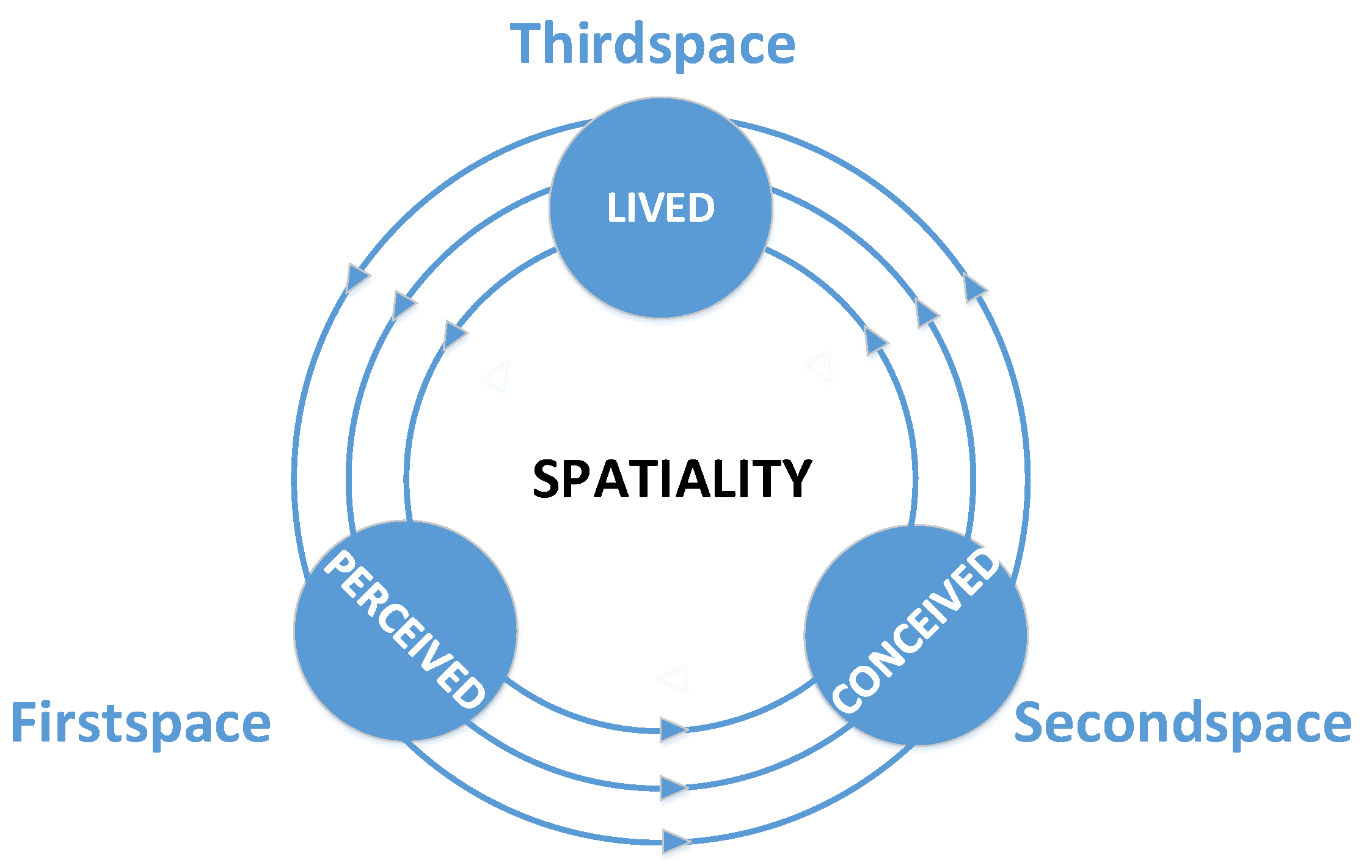
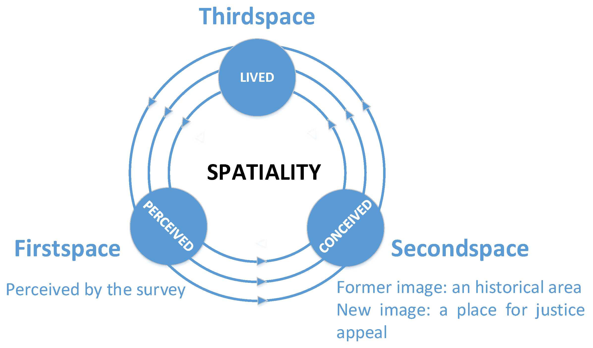
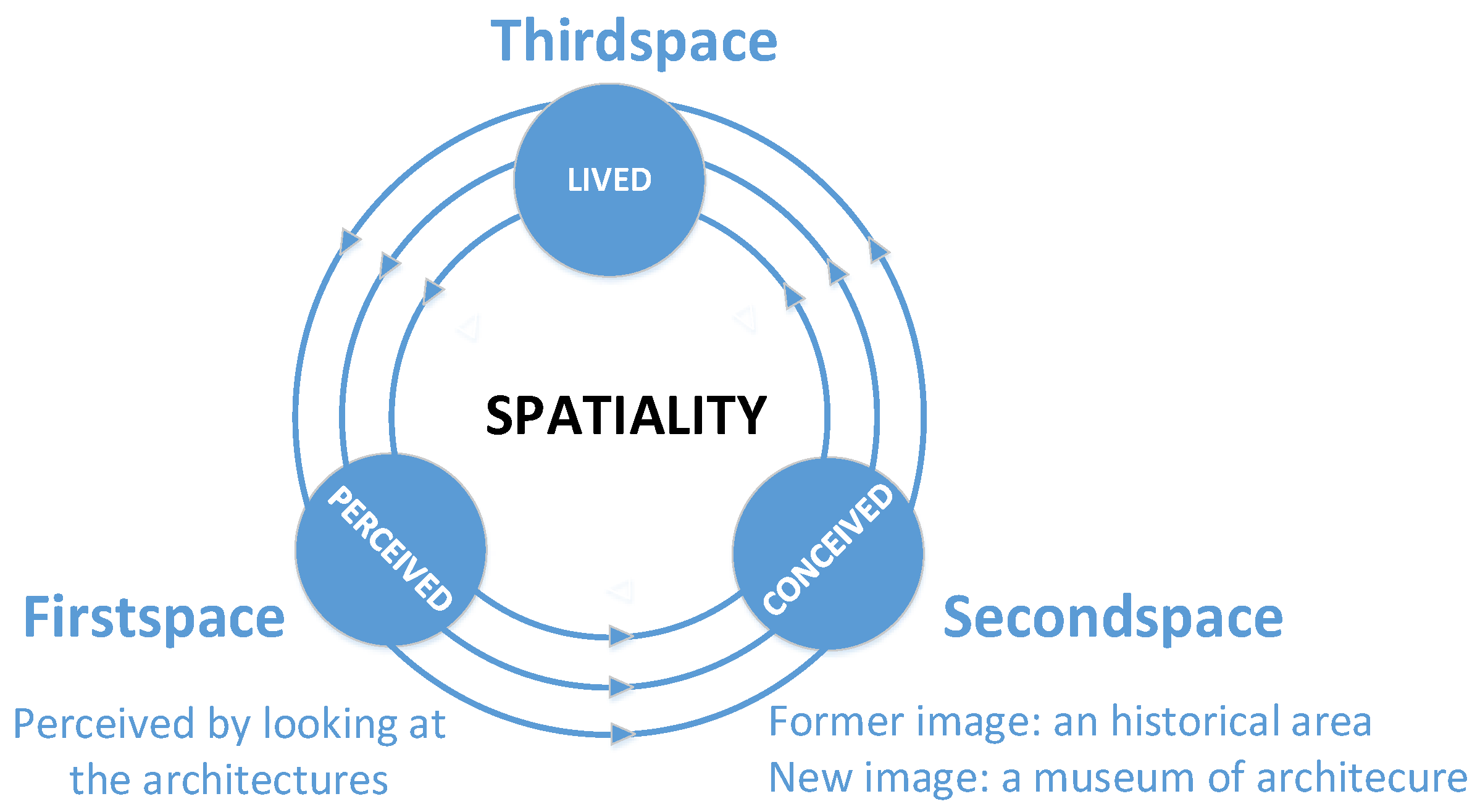
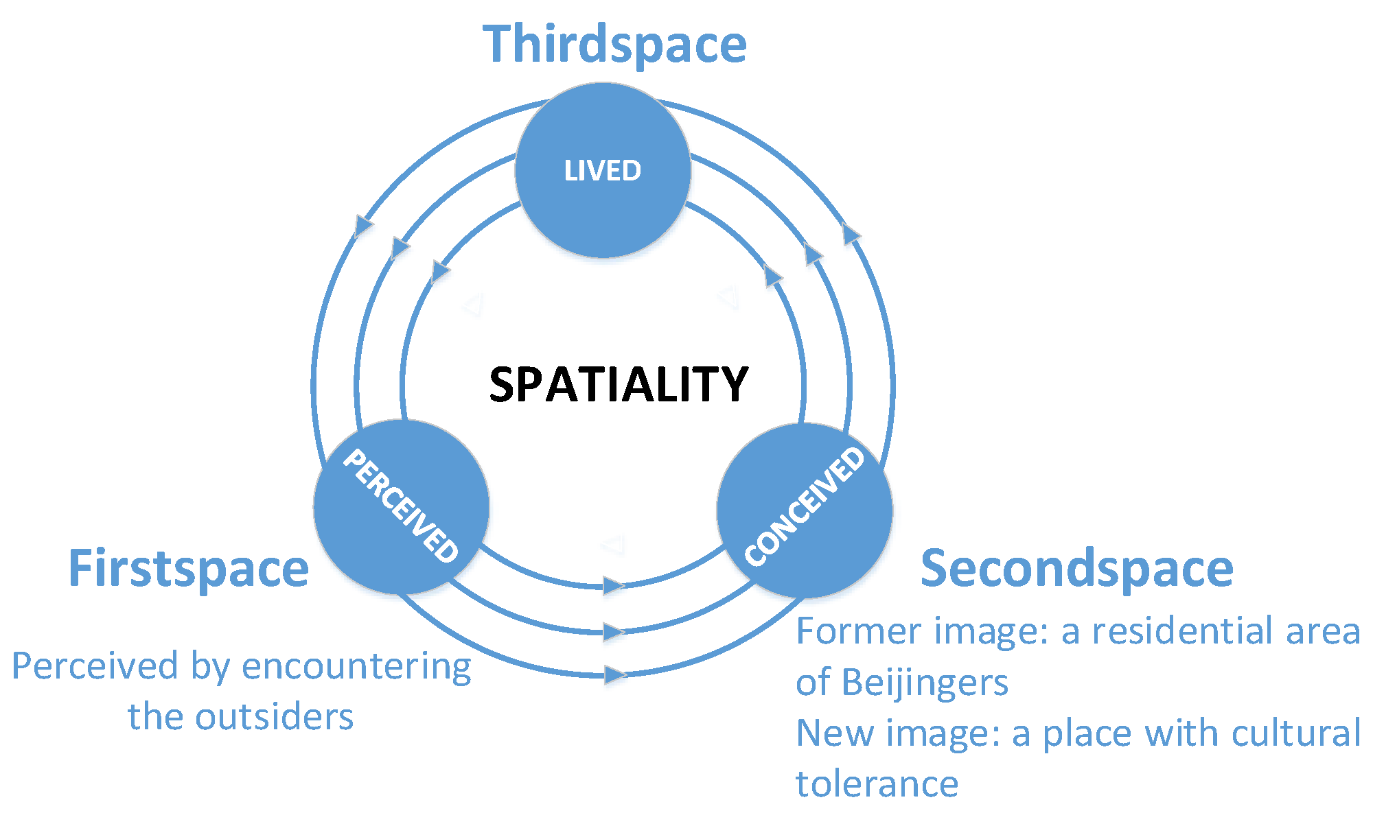
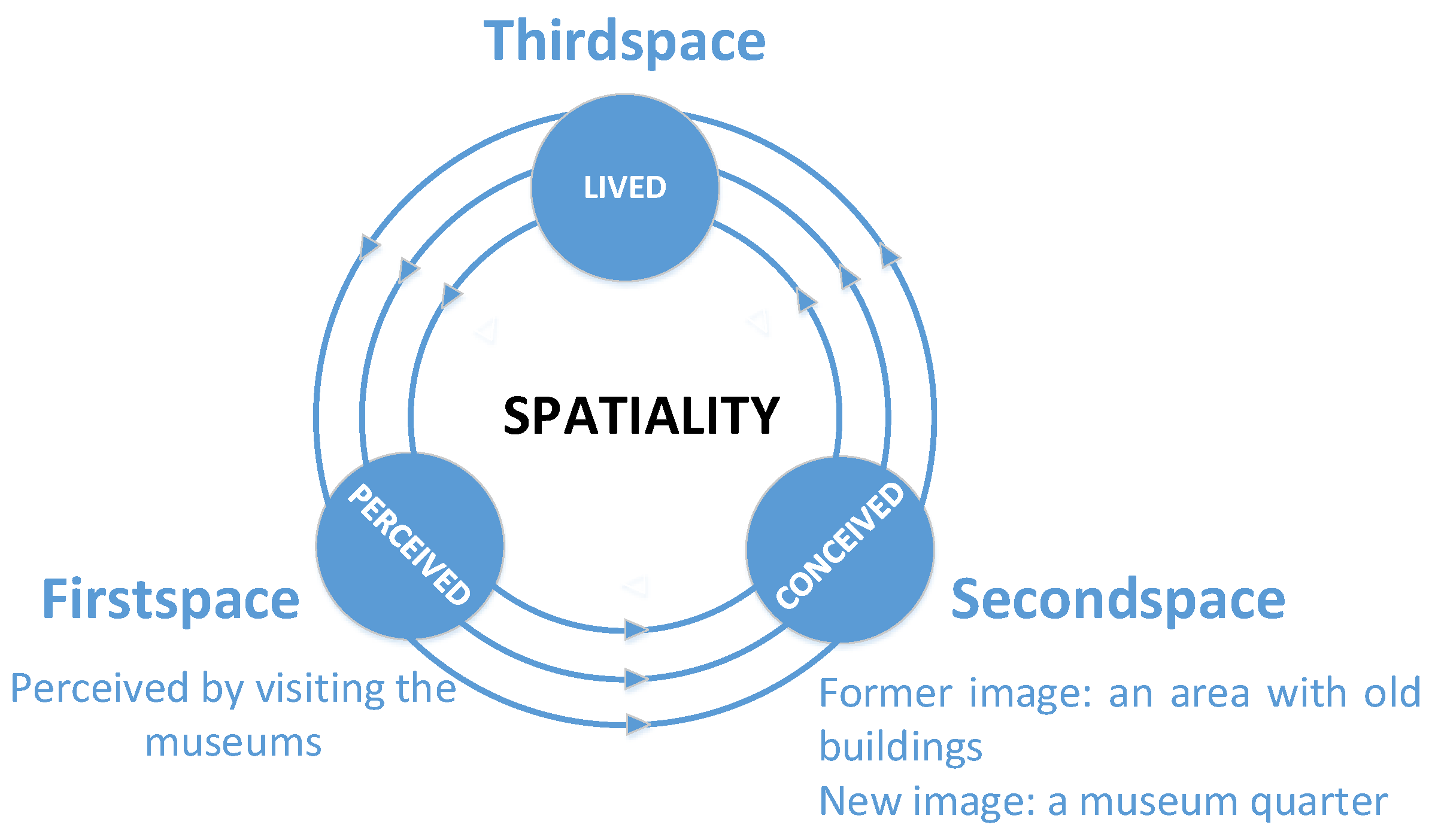
Soja’s trialectics of spatiality is based on Henri Lefebvre’s description of three kinds of space [28,29]. Soja outlined what he called the Firstspace epistemology, the Secondspace epistemology and the Thirdspace epistemology, which supported the establishment of a research framework for this investigation (see Figure 1). “Firstspace epistemology” focuses on analyzing and interpreting the text of physical objects in perceived space [30]. Firstspace epistemology holds that spatial practice and material geographies are the result of history and sociality. “Secondspace epistemology” focuses on obtaining ideas from the conceived space and projecting them onto the world of experience. This type of epistemology breeds a wide range of philosophical hegemonies and utopian thinking. “Thirdspace epistemology” focuses on making endless sympathetic deconstructions and heuristic reconstructions of perceived space and conceived space by injecting new possibilities into the “lived space”. In this way, the heterotopia will spiral and result in an infinite approach to the state of utopia. In Thirdspace epistemology, real space has both subjectivity and objectivity, abstraction and concretization, reality and imagination, known and unknown, repetition and difference, construction and deconstruction, thought and body, consciousness and unconsciousness, singularity and diversity, daily life and endless history [31,32]. Soja found that the Firstspace and Secondspace epistemologies are rigid and closed. The structure does not concentrate on the real spatial awareness or on an appropriate practical guideline [31]. Soja suggested that spatialization can be understood better with the guidance of the Thirdspace epistemology. This process of spatialization is a critical and continuously expanding journey [33]. Furthermore, Soja pointed out the morality concealed in the Thirdspace [31]. In this study, we are seeking the starting point of our thinking according to this epistemological framework to explain the multiple images and fluid images of a historical area. Meanwhile, we also attempt to find the morality in the process of spatialization.
2.3. The Research Application of the Trialectics of Spatiality
Many scholars have noted that Soja’s trialectics of spatiality provides a new postmodernist angle for describing how people perceive, conceive, and reconstruct a place [34,35]. Soja’s trialectics emphasizes thinking differently about the meaning and significance of space [36,37]. It instructs us to pay more attention to the experiential gap between real and imagined space [38,39]. His trialectics of spatiality has also been used to construct different types of spatial research [40,41]. These studies can be roughly divided into two categories.
The first category concerns different senses of place among various groups and among the individuals within a group. The trialectics of spatiality is used to study this multi-type space. Using this approach some scholars have demonstrated that the real space is a multiple convergence of different subjects. Hooks introduced trialectics into the creative postmodernist theory for the politics of different cultures. Using the story of the railroad and black aesthetics, Hooks showed that due to the structure of daily life, blacks had a sense of overall consciousness, which included the angles of blacks and whites. From the standpoint of “others”, everyone cannot only discover the beauty of the edge space, but also find the courage to make fiercely debate and struggle in space. By this means, a variety of new and radical things converged [42,43]. Using Soja’s trialectics of spatiality, Hejnal conducted research in the “Hilton” space (the emic name of the object inhabited by homeless people in a mid-sized Czech city). Hejnal divided research spaces into three categories: Firstspace is the object space which is described as historical and physical; Secondspace is the representation space of the main subjects, in which politicians, government police, the local media and the public is included; Thirdspace is the heterogeneous “Hilton” from the angle of the main subjects. The researchers focused on the differences and connections between these three spaces. The research of “Hilton” space showed that there were many contradictions between these three spaces. The main subjects’ passive description and their strong social relations and internal social practices inside made the “Hilton” space seem like a contradictory and absurd platform, where contradictions exist between the filthy external environment and the clean status inside a building, with different attitudes towards dogs, odor, ecology, health, etc. Due to the residents’ negative views of the homeless, the routine inspection of the “Hilton” by the police had become legal. On the one hand, the public wished to solve the problems, but on the other hand, they also rejected the feasible solutions. From the study of Hejnal, the three spaces seemed to oppose each other and correspond to different subjects; in fact they closely intertwine. Soja’s trialectics of spatiality stresses that spatialization is in a continuous and spiraling process [44]. Murrani used Soja’s trialectics of spatiality to emphasize that there is always a new subjective power entering the urban space of Baghdad, which also influences the urban spatial pattern as well. American troops were involved in the spatial understanding of Baghdad with the locals on Twitter. Thus, the urban space of Baghdad was continuously being constructed and deconstructed [45]. Refstie and Brun applied the trialectics of spatiality to explore the different participations of different agents (including the government, international organizations and the community residents) in urban planning. The participation of different groups makes it possible to fulfill the multiple requirements from various subjects for urban planning [46]. In addition, some scholars have analyzed the perceptions and practices of subjects under the same environmental protection through the trialectics of spatiality. Anderson introduced the trialectics of spatiality into the exploration of the environmentally directed action. He believed that the trialectics of spatiality could result in the researchers forming the most realistic recognition of their political practice. Anderson considered the Firstspace to be the empirical and measurable space (activist space), whereas the Secondspace was the cognitive and reasonable space (academic space), and the Thirdspace was a lived space in which the emotional activism and the rational academics were joined together. By means of the trialectics of spatiality, Anderson removed the scholar’s hat, forming the same target as the environmental protection activists in some situations, and obtaining the occasional and one-time comments from different environmental activists in their group. Also, Anderson found that the trialectics of spatiality can be used to resolve the contradictions between scholars and activists, the debates among different scholars held various epistemologies and methodologies, and even the contradictions of the scholars themselves at different periods in their career. From the standpoint of the trialectics of spatiality, Anderson indicated that diversity is the nature of reality. No matter how uncomfortable the situation is when individuals suffer the impact of the practices of others, he or she should incorporate this kind of diversity. Anderson’s study echoed the diversity and fluidity inherent in the trialectics of spatiality [47]. Munjee (2014) tried to appreciate the aesthetics of site-specific dance using the model of trialectics of spatiality. Munjee classified different elements of site-specific dance into perceived, conceived, and lived space, based on the audience realizing the values of these elements in performance. The perceived space included the natural and human parameters of physical space. The conceived space stressed that the diverse identities and subjective viewpoints of locals would affect their understanding of the site-specific dance in the physical space. The lived space concentrated on the role body practices played in the production of space, which contained not only the daily movement but also the abstract performance. Based on this, Munjee concluded that Soja’s trialectics of spatiality cannot only improve the diversity of aesthetic understanding among different students, but also form the multiple interpretations holding for a public space [48].
The second category of research concerns the changes in an individual’s sense of place. Some scholars have concluded that spatial practice and conception are not static when using the trialectics of spatiality. Swenson applied the trialectics of spatiality to analyze the perception space, conception space, and real space of a local commemorative building. He found that there were only conservative political forces for the perception and conception of the building, and that only the Thirdspace could help to break through this line of thinking. The purpose of every inspection and renovation for local monuments was to construct the individual personality of a special historical period. In this process, community and power played an innovative role. The trialectics of spatiality provides epistemological and methodological guidelines for many fields, including geography, sociology, archeology, and environmental protection [49]. However, there are relatively few cases have been applied to urban planning. Based on this point, Detamour believed that the subjects who are in the edge space could form a brand new and more inclusive understanding of the urban space. This study paid close attention to the different kinds of text, including photographs, drawings, and literature to discover the subjects’ comprehensions of the heterogeneous urban space. Different subjects were always in the process of perceiving and conceiving their living space. Under the gaze of these art texts, Detamour noted that different individuals were always in the process of the spatial movement. The individuals’ bodies occupy the space, and this occupied space is important since both interact with each other and constantly create a new space. The trialectics of spatiality can capture the Thirdspace of the artistic creators when they jump out of a simple objective space and a subjective space. Detamour’s study recognized the heterogeneous nature of a space, but that space should not exclude the coexistence of the different individuals. Based on this premise, this study suggested that urban planning should recognize the relationships between different regions rather than separating them. The research deconstructed and evaluated the perception and cognition of the subjects, and advanced some suggestions for the design of an inclusive urban space [50]. Using Soja’s trialectics of spatiality as a reference, Prasetyo considered the sidewalk in an urban space in a different way. From the perspective of Thirdspace, he argued that the sidewalk was not just a physical space on which people move, but also a tool to promote the social and cultural network. The sidewalk was a playroom in which citizens could participate in political and cultural activities and exchanges. Therefore, the trialectics of spatiality can inject new vigor and fluidity into the understanding of urban space, thus liberating the urban space from obstacles and restrictions [51]. Teelucksingh and Masuda used the trialectics of spatiality to analyze the environment perception and cognition of different spatial individuals in a community. At the beginning of the investigation, the respondents just had a simple physical perception of the others’ community. However, through the investigation, respondents formed their own cognition. Finally, they were able to integrate the perception and cognition into their true stories and put forward their own advice on environmental issues. This process awakened the consciousness of the individual to their urban rights [52]. However, their study emphasized the other’s impact on the conscious awakening of the individuals inside the space, raising their self-consciousness was ignored as the classification of “others” was too simple.
In our case study, we also use the trialectics of spatiality to discuss the diverse images of people and the image changes of an individual. However, our major aim is to determine the analytical procedure for the trialectics of spatiality, which was not demonstrated clearly in the above case studies.
2.4. Debates Concerning Soja’s Trialectics of Spatiality
There are also some risks that should be realized when using the trialectics of spatiality. The critique of Soja’s trialectics of spatiality can be divided into two categories: the theoretical criticisms and the practical criticisms. The theoretical criticisms include the followings: First, some scholars have questioned the logical relationship between the three spaces. Merrifield suspected that perceived space which is full of spatial practices cannot be directly equivalent to Firstspace. He believed that spatial practice is the key to combining the conceived space and lived spaces [53]. Second, some scholars have also questioned the verification process of Soja’s trialectics of spatiality. Crang expressed some uncertainty as to whether Soja’s rethinking of spatiality results from the trialectics circle, or whether the trialectics circle is the result of Soja’s rethinking [54]. Schreiner argued that spatial theories (such as Soja’s concept of Thirdspace) are not the reflection of the real space, but should be assessed via a historical analysis. However, this kind of spatial concept also provides a more flexible and comprehensive way to look at the world [55]. The practical criticisms include the following: Some scholars have argued that Soja’s case studies were insufficient for any theoretical explanation. Merrifield regarded Soja’s case studies for the trialectics of spatiality as being too redundant to clarify his theory. He noted that Soja did not explain how to apply the theory of trialectics of space into real world practice [53]. Moss felt perplexed about the applicability of the trialectics of spatiality because of its narrow use in both theoretical and practical terms. However, even though the research had limited citations and exaggerated expressions, Moss agreed that the trialectics of spatiality is a way to improve our epistemological composition of space [56]. Therefore, our article responds to these scholars’ criticisms of the trialectics of spatiality by defining the three kinds of space, and by explaining the circle they comprise in the trialectics of spatiality.
The literature mentioned above does provide us with some illumination. This research not only paid close attention to improvements in spatial understanding when people changed their mental images of DJMX, but also aimed to determine an analytical procedure for Soja’s trialectics of spatiality, a feature which is still lacking in the relevant research.
3. Methodology
3.1. Study Area
The research area of this study is DJMX, a historical area in Beijing. We conducted surveys in DJMX from 28 November to 10 December 2015. First, on 28 November we conducted a pre-survey of DJMX to define our study area. Second, from 29 November to 10th December, we conducted the detailed questionnaires and structured interviews within DJMX.
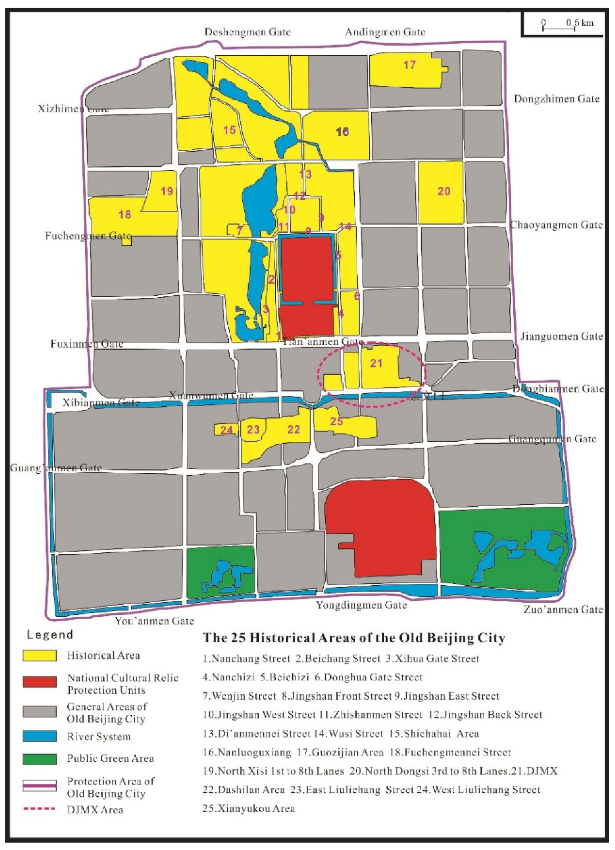
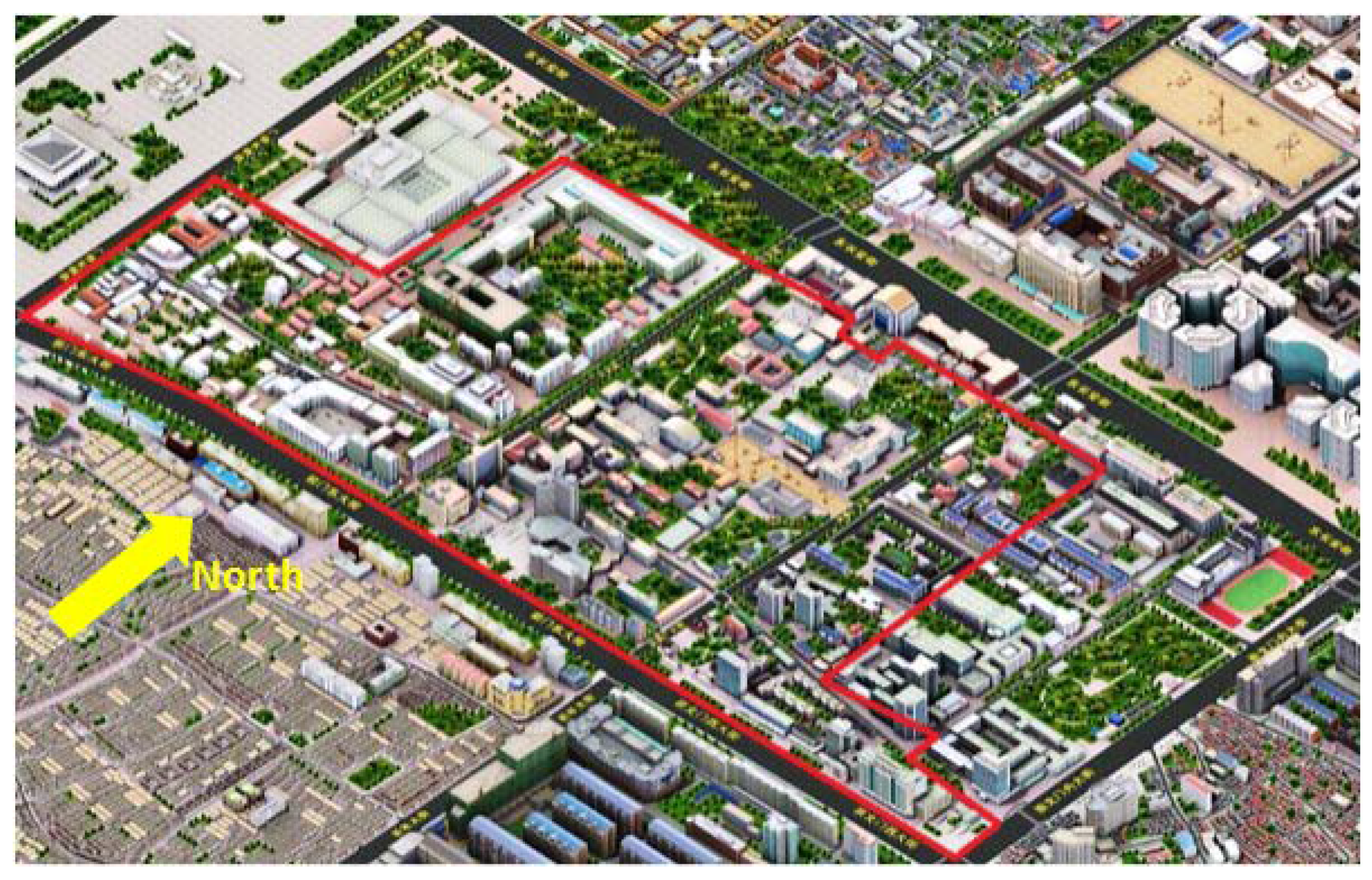
In 1990, DJMX became one of the 25 historical areas in the old city of Beijing (see Figure 2). It is a microcosm of history and has witnessed much of what has happened in both the past and the present. DJMX is located on the east side of Tiananmen Square and on the south side of the National Museum of History. The total area of DJMX is 628,400 square meters (see Figure 3). During the Ming Dynasty, the Ministry of Personnel, the Ministry of Revenue, the Ministry of Rites and the Imperial Clan Court were in this area. In the Qing Dynasty, besides these administrative ministries, the Huitongguan which was responsible for the reception of the tributaries’ envoys was also set up in DJMX. The tributaries’ envoys from Annan, Myanmar, Korea and Mongolia stayed in the Ethnic House (it was renamed to Imperial Translation Training Agency of Regional Languages in the Qing Dynasty). From 1860, the Qing government signed the Treaty of Tianjin with Britain, France, the United States, and Russia, respectively. Also, Britain, France, and other countries established embassies in DJMX. After 1900, DJMX became the Beijing Legation Quarter and its name on the map was officially changed to DJMX. The Western-style buildings which included the foreign banks, the French post office, hospitals and other facilities had been constructed consequently in DJMX. After 1937, the Beijing Legation Quarter was handed over to the government of the Republic of China. After the establishment of the People’s Republic of China in 1949, DJMX was still regarded as the Beijing Legation Quarter, and some of the embassies (including the East Germany, Hungary, etc.) were located there as before. In 1959, the embassies moved out from DJMX. In 1995, twelve places within the DJMX historical area were listed in the fifth batch of Beijing cultural relics protection units [57,58].
In 2004, the Municipality of Beijing formally approved The Conservation Planning of 25 Pieces of Historical Areas in the Old Beijing City. In this document, some of the 25 historical areas were labeled with single image. For example, Qianmen-Dashilan is “the old business district of Beijing”, Nanluoguxiang is “the old residential area”, and Guozijian is “the former Imperial Academy”. However, DJMX has not yet been given a clear image or a label. Some studies have introduced DJMX as the former embassy district [59,60], and other research considered DJMX as the former CBD of Beijing at the end of the Qing Dynasty [61]. Compared with the other historical areas in Beijing, the biggest difference is that the role that DJMX played, whenever in the past or present, is not a single one. DJMX’s functions are continuously changing and have become more diverse than ever before. For this reason, we think that DJMX is a typical location for conducting surveys. By applying Soja’s trialectics of spatiality, this study attempts to determine whether it is beneficial or not to label DJMX with a single image. This case study also aims to provide a reference for labeling the historical areas.
3.2. The Framework of the Methodology
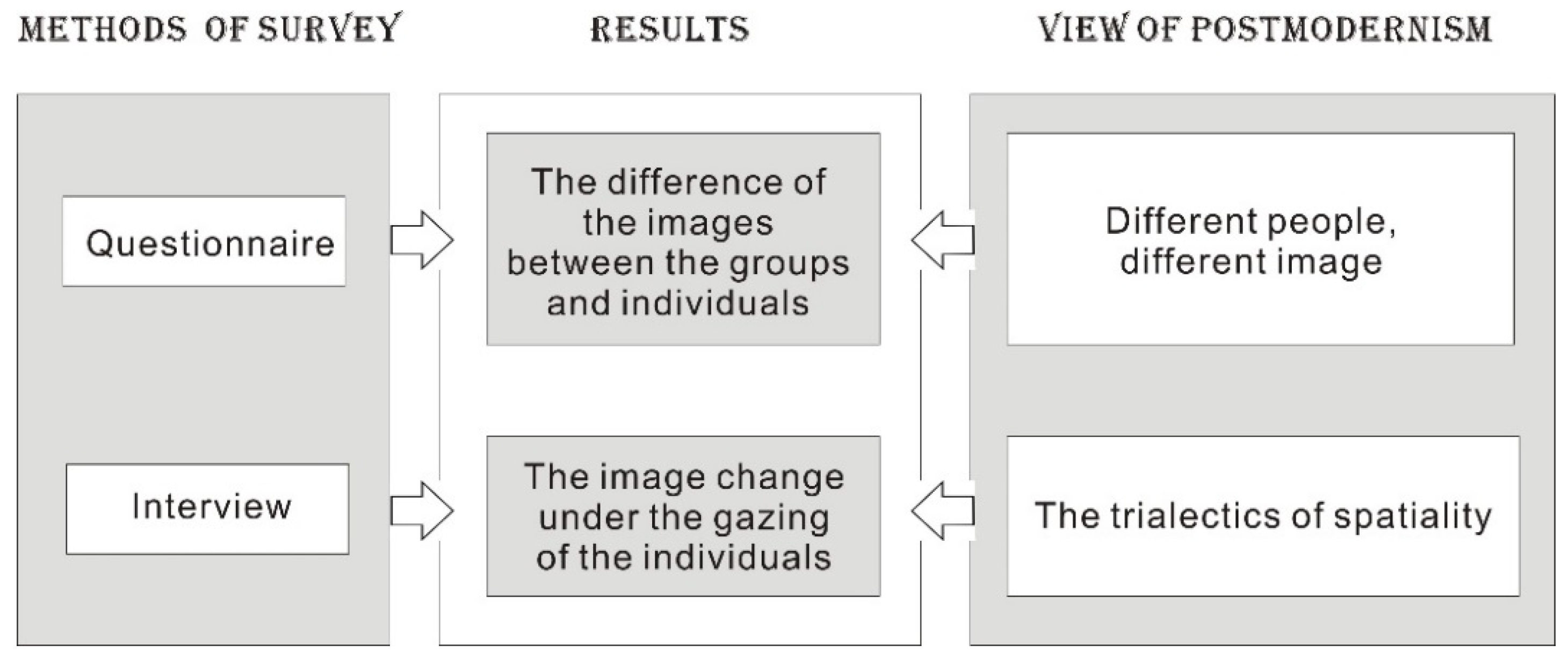
There were two methods involved in the survey process (see Figure 4). The first method of the survey was using a questionnaire. The questionnaire was distributed among scholars and writers in related fields, locals, and tourists. A total of 146 questionnaires were distributed and the response rate was 98.6%. The questionnaire was designed to collect information about the respondents’ attributes and the images of DJMX. The respondents’ attributes include gender, the length of residence in DJMX, age, and educational level. Then the respondents were asked to choose and rank the image of DJMX in their mind from the options in the questionnaire, in which more than one image was allowed. Every respondent finished the questionnaire for more than 30 min. After the questionnaires were collected, we analyzed the different images among the people of varying groups and within a group by using Pearson’s correlation. The second method was conducting the interviews. We investigated the image changes of some typical individuals, including a scholar, a writer, a local resident and a tourist. The trialectics of spatiality was applied as an analytical tool. Figure 4 shows the framework of this research. In our research, we took the postmodernist approach as the basis and tools for the results analysis.
3.3. Analysis of the Questionnaire
Based on the framework, we used selected variables to evaluate the respondents’ images of space. In this process, we took the individual attributes as the independent variables and the image scores as the dependent variable (see Table 1).
● Evaluation of the historical sense of images
represents the historical sense,
represents the current image of the individual, represents the coefficient of
(, , ),
represents the expectant image of the individual.
● Evaluation of the urban functional sense of images
represents functional sense,
represents the current image of the individual,
represents the coefficient of L,
(, , ),
represents the expectant image of the individual.
● Evaluation of the political sense of images
represents political sense,
represents the current image of the individual,
represents the coefficient of
(, ),
represents the expectant image of the individual.
4. Results
Based on above formulas, we calculated the score of images and senses of different individuals. The different scores of the image and senses show the different perceptions of the respondents for DJMX. After getting the calculated results, we wanted to discover if any consistencies existed in the individual’s images both among and inside the groups, even for a single interviewee.
4.1. Image Analysis between and inside the Groups
4.1.1. Image Analysis between Different Groups
● Image analysis between groups with different length of residence in DJMX
In order to know whether the length of residence has an impact on the different subjects’ image for DJMX, we chose subjects No. 3 and No. 12, who had different standardized values for the length of residence in DJMX but the same standardized values of age and education level.
From Table 2 and Table 3, we can see that people in the groups with different length of residence in DJMX hold various images.
● Image analysis between the different age groups
In order to know whether the subjects in the different age groups hold the different images, we chose subjects No. 22 and No. 23, who had different standardized values for ages, but the same standardized values for the length of residence in DJMX and education level.
● Image analysis between the different education level groups.
In order to know whether the subjects in the different education level groups hold different images, we chose subjects No. 17 and No. 26 for the image analysis. These subjects had different standardized values of education level, but the same standardized values of the length of residence in DJMX and age.
From Table 6 and Table 7, we can see that people in the different education level groups hold various images.
From the above analysis of the questionnaire, we found that the images of DJMX are different among the different groups. By comparing the different groups, which have distinctive attributes in the length of residence in DJMX, age and education level, we found that respondents’ current and expectant images of DJMX vary among the different groups.
4.1.2. Image Analysis inside the Same Group
Pearson’s Correlation Coefficient was then applied to unearth the relationships between the attributes of the subjects and their historical, practical, and political sense regarding the current image of DJMX. We used SPSS 16.0. According to empirical observations, the degree of correlation between variables was divided into the following cases: when , there is a high degree of correlation; when , there is a moderate correlation; when , there is a low correlation; when , it is not worthy to do further analysis because the correlation is not significant enough.
According to Table 8 we observed the following: from the current images, the length of residence in DJMX is positively correlated with the historical sense but negatively correlated with the political sense; age is positively correlated with the practical sense from the current images (at the 0.05 level), but these correlations are very weak (). Besides, there is no significant correlation between the other variables.
From the above analysis of the questionnaire, we found that the current images of DJMX are different among the individuals in the same group. The three main group attributes: the length of residence in DJMX, age and educational level are not significantly related to the historical, practical, and political sense of DJMX from current images. Also, the different groups have no obvious tendency in their images and senses of DJMX, which ran contrary to our intuition thinking. Thus, we concluded that the image inside the same group about DJMX shows the characteristics of diversity, mobility and non-centricity.
Furthermore, we investigated the senses of DJMX from the expectant images to explore the attitudes of different subjects about spatial usage and protection. Based on the correlation coefficient between the groups’ attributes and senses of DJMX from the expectant images, we can judge the degree of correlation between the spatial protection target and the groups’ attributes.
According to Table 9 we observed the following: from the expectant images, educational level is negatively correlated with the expectant historical and practical sense (at the 0.01 level), but these correlations are very weak (). Besides, there is no significant correlation between the other variables.
From the above analysis of the questionnaire, we found that the expectant images of DJMX are different among the individuals in the same group. The three main groups with different attributes: the length of residence in DJMX, age and educational level, have no significant correlation with the historical, practical and political sense of DJMX from expectant images. This shows that people’s expectant images of DJMX also different even in the same demographic or educational category.
In summary, the questionnaire shows that the images of DJMX are different among groups and individuals. Based on the comparison among different groups, which had following distinctive attributes: the length of residence in DJMX, age, and educational levels, we learned that people in different groups have different images of DJMX; The three main attributes listed above have no significant correlation with the historical, practical and political sense of the image, which indicates that people’s images of DJMX are different even within a same group. In the following analysis, we will try to find out if the individuals’ image changed when they gazed upon the landscape of DJMX.
4.2. Image Analysis for the Individuals
We adopted Soja’s trialectics of spatiality to further describe the image forming process of the interviewees.
4.2.1. Image Forming Process of Individuals
[Interviewee 1] The change in a geography professor’s image of DJMX (Ms. Zhou, 1960-, female, researcher for Beijing historical heritage preservation and planning).
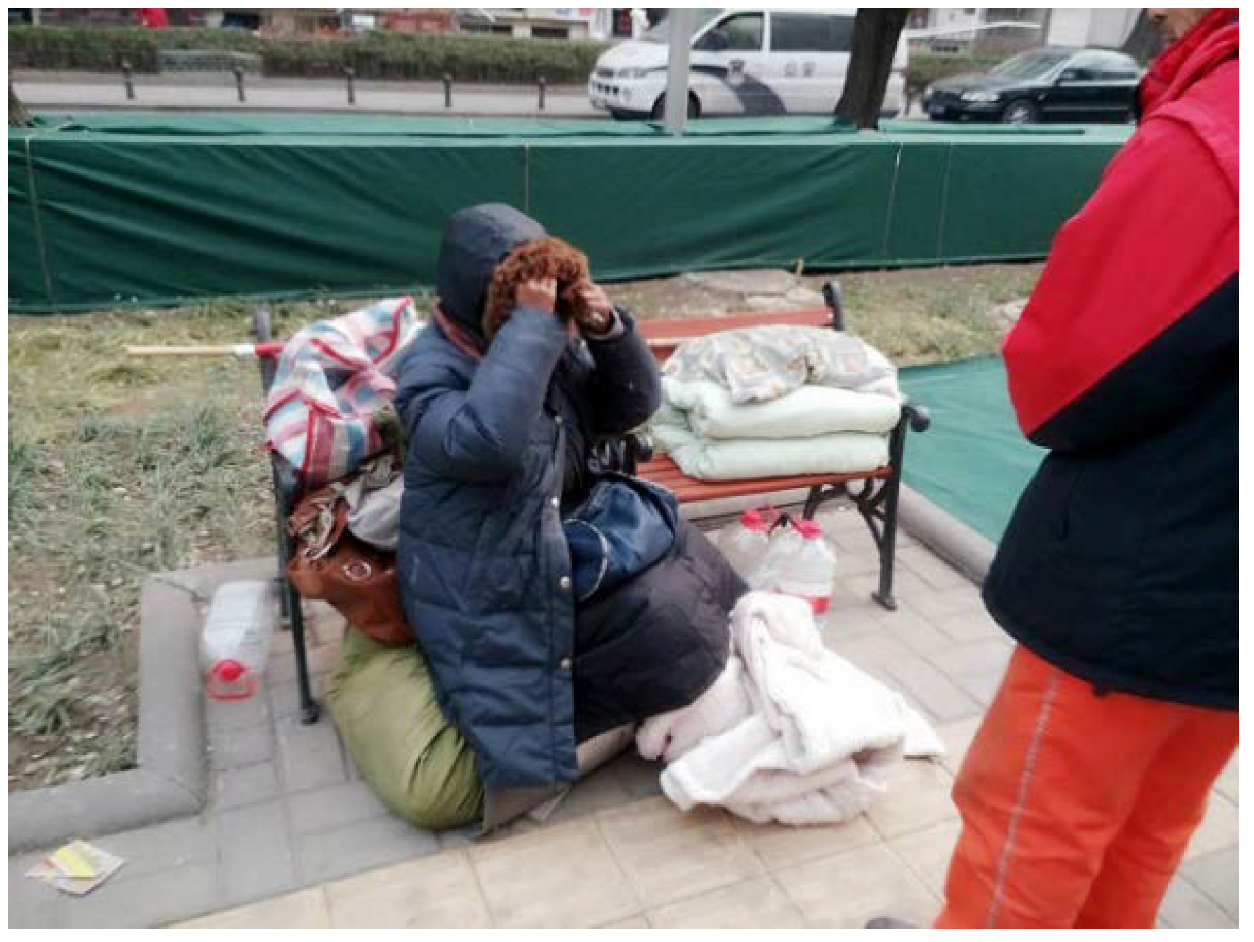
“My first image of DJMX was that it is a historical and cultural preservation area [Secondspace]. Each street and building we see is a carrier of history and culture, and what we want to protect are the physical elements and historical story. When I did a survey in DJMX [Thirdspace], a petitioner on the street corner talked to me. She was wrapped in a thick cotton quilt, curled up in the cold wind (see Figure 5). I did not know what her concern was, but I discovered that the reason she chose DJMX to express her appeal was that the Supreme Court of China is located in DJMX. Therefore, I perceive a new image of DJMX [Firstspace]. That is not only a place of historical and cultural heritage, but also a place to appeal for justice [new Secondspace] (see Figure 6).”
[Interviewee 2] The change in an historian’s image of DJMX (Mr. Fang (1945-), male, writer and editor, expert on Beijing’s history).
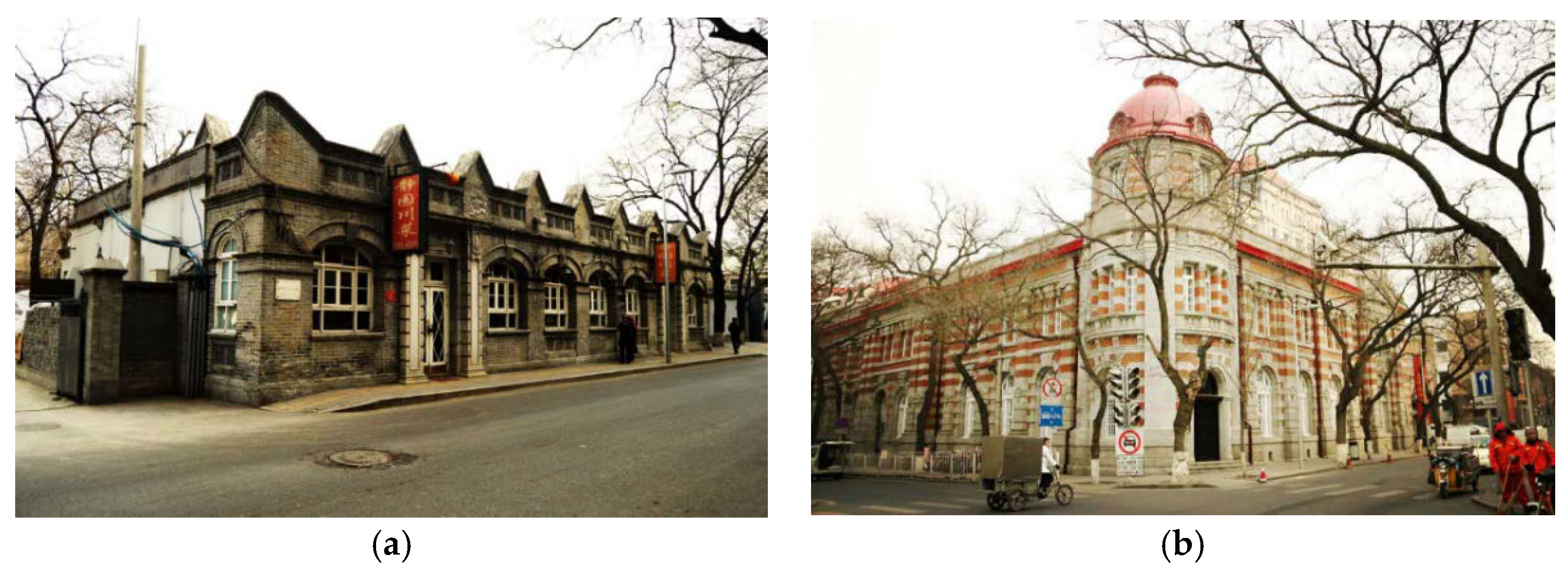
“My previous image of DJMX was a main commercial street in the Ming Dynasty and the embassy area in the late Qing Dynasty (see Figure 7). Many significant historical events happened in DJMX. DJMX had recorded the historical evolution of China from the Ming Dynasty to the early period of the Republic. I introduced DJMX to the students before as a place showing the shameful history of Semi-feudal and semi-colonial China, which came from a historical textbook [Secondspace]. But this time I found that the students and the tourists paid close attention to the aesthetics of the Western-style architectures in DJMX [Thirdspace]. It is far from what I expected [Firstspace]. So, I have another image of DJMX. It is an open museum for western architectures [new Secondspace] (see Figure 8). When we face the history, we need to see the both sides of the history.”
[Interviewee 3] The change in a resident’s image of DJMX (Jin, male, a local resident in DJMX, 40 years old, junior high school educated).
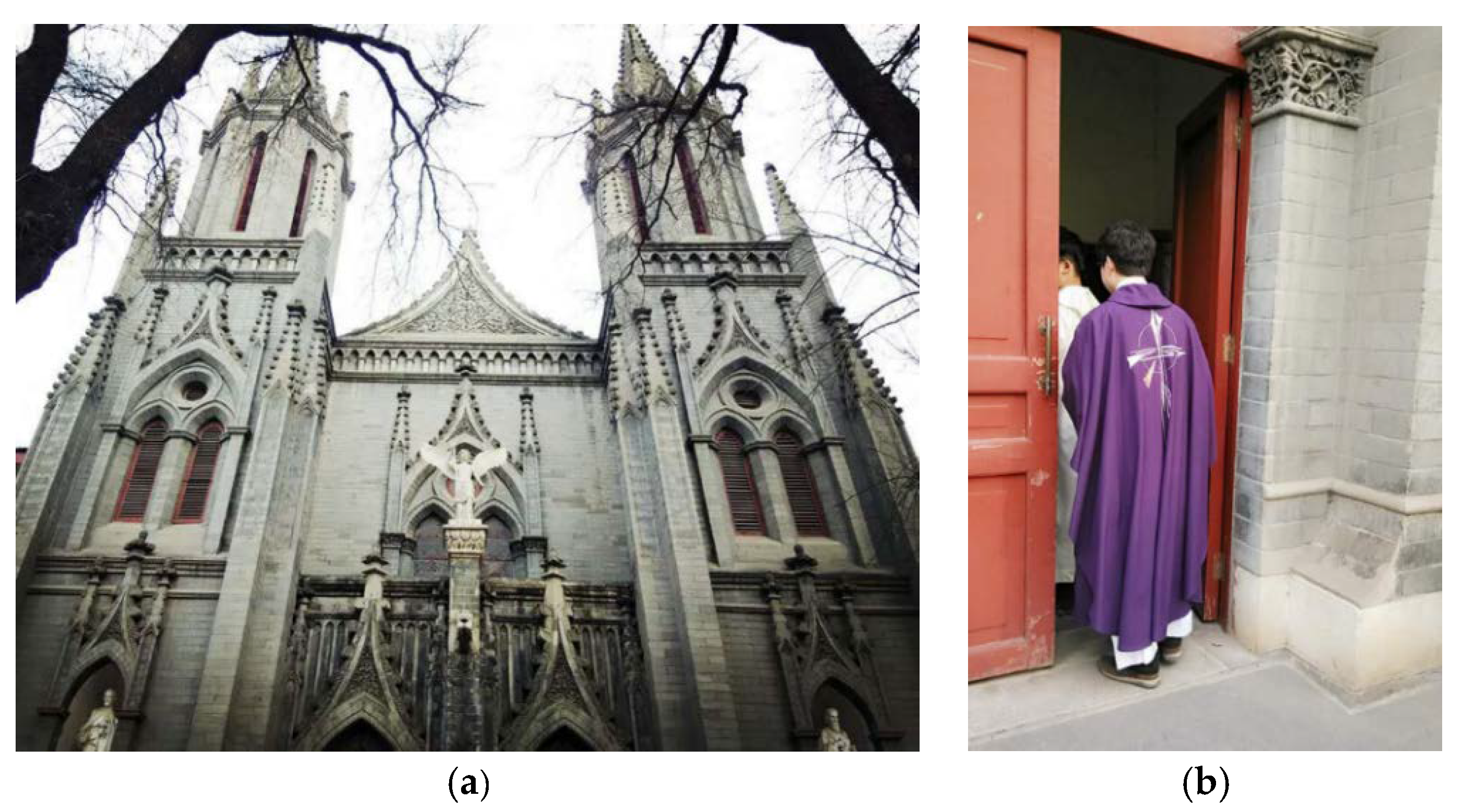
“I have lived here for many years. I thought DJMX was mainly a residential neighborhood [Secondspace]. Many old Beijingers have lived here for generations. Of course, there are some outsiders renting apartments here. In the eyes of the local residents, every building and street is full of memories of our own and our family’s life [Thirdspace]. Everyone has the right to live here. I was unhappy when I first saw that the South Korean Catholics had occupied the Catholic Church on the east end of this street (see Figure 9). But now I gradually accept it because DJMX does not only belong to the local people, but also belong to the outsiders [Firstspace]. That’s why I think DJMX should be a culturally inclusive area [new Secondspace] (see Figure 10).”
[Interviewee 4] The change in a tourist’s image of DJMX (Miss Wang, female, a tourist from Taiwan, 22 years old, college student).
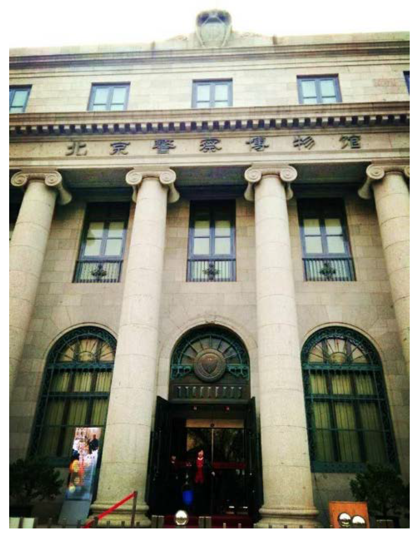
“My original image of DJMX was from a description in a traveling guide: different from the gray walls, green tiles and ancient homes of the normal Beijing Hutong, DJMX preserves its large-scale Western buildings [Secondspace]. When I came here, it gave me so many surprises [Thirdspace]. Many historical buildings have been reused as museums. For example, the former Citibank became the Beijing Police Museum now [Firstspace] (see Figure 11). I thought DJMX was only a Western Building Protection Area, but it is also an area with various museums [new Secondspace] (see Figure 12). I like this way of historic preservation. It allows DJMX to not only preserve the old architectures, but also give new vitality by using them as museums.”
4.2.2. Image Characterization with the Trialectics of Spatiality
Based on the analysis of the interviews by using the methodology of the trialectics of spatiality, we found that the image of DJMX in the mind of each interviewee had been changed when s/he gazed at DJMX. The changes in the images of DJMX is a continuous process for individuals. Such a process lets people renew their understanding of the space, such as the justice-seeking, discovery of aesthetics, realization of tolerance, and the sustainable use of the old buildings in the four cases [31]. The changes in the images of the four interviewees can be understood through the trialectics of spatiality. First, they provided an initial perception based on their own spatial practice and then they conceived an image based on their perception. After the new lived practices, the interviewees’ experiences broke their former image and formed a new image that is closer to the reality at that moment. However, this process never stops, and the newly conceived image may become the starting point of the next round of spatial understanding. Such a spiraling cognitive process overcomes the ethical paradox of postmodernism, which was suggested by Bauman [1]. As time goes by, the understanding of goodness and beauty are relative, but the spiraling process of conception is absolute.
Above all, the results indicate the following: (1) the questionnaire shows the images of DJMX are different among the groups and the individuals; (2) interviews with four interviewees shows that the image of DJMX changed in the mind of each interviewee when they gazed upon DJMX. These results thus provide support to Soja’s trialectics of spatiality.
5. Discussions and Conclusions
Based on the research results, this article has reached the following conclusions:
The first conclusion is that the urban planners do not need to label a historical area with a specific image. This is because that the individual’s image of a historical area continues to form and change in an endless process. Not labeling a historical area may give people more freedom to renew their understandings of it. This creative flexibility is one of the advantages of postmodernist urban planning [64]. Although the results of the survey reveal that people have multiple images of DJMX, we should still not regard “not labeling” as the only means of historical area preservation.
The second conclusion is that the Secondspace or the conceived space in Soja’s trialectics of spatiality may be a good starting point for analysis when people apply Soja’s trialectics of spatiality as a methodology. After we interviewed the four interviewees and collated what they said, we found that the Secondspace of the interviewee was clear and simple enough to be written down by interviewers. However, more sentences needed to be recorded in the notebook when the interviewers wanted to capture the Firstspace of the interviewees. It was impossible for the interviewers to cover everything of the Thirdspace, which always offers people infinite possibilities to understand the world. Accordingly, it may be difficult to enter Soja’s trialectics of spatiality through Firstspace and Thirdspace. Although we suggest taking the Secondspace as the starting point for using the trialectics of spatiality, we do not mean that the Secondspace is the best starting point for analysis, because postmodernist planning does not allow for any absolutely ”best” or ”right” method. This research is also an effort to address the debate on Soja’s trialectics of spatiality [53]. We try to show the reader of this study that there is a clear path for the widespread application of Soja’s trialectics of spatiality.
We have two points for further discussion. One is that the four interviewees showed their thinking process in a counter-clockwise direction (see Figure 6, Figure 8, Figure 10 and Figure 12). Is the thinking process in a clockwise direction more difficult? This has not been discussed in this article. Thinking from Firstspace to Secondspace means that practice determines knowledge. Thinking from the Secondspace to Firstspace means that practice is guided by knowledge. We have not tried to explore the later process. The other point of further discussion is linking Soja’s trialectics and Marx’s dialectics. From the standpoint of the Marxism, the Firstspace and the Secondspace are more basic spaces. Learning from the dialectics of Marxism, Soja tried to search for something of value between the Firstspace and Secondspace. In a sense, spatial practices are the dialectical pressure points for keeping the conceived and the lived together, yet also apart. Many Chinese scholars and students are familiar with Marx’s dialectics. Thus, it will be easier for them to understand Soja’s definition of Secondspace and Firstspace, rather than Thirdspace. Thirdspace, as a postmodernist concept, seems to have broken the duality between the material and spiritual space. This article only discusses that the Thirdspace gives people more freedom to perceive and conceive of DJMX again and again but has not proposed any other possible advantages.
Author Contributions
S.Z. made the methodology framework of this project and wrote some parts of this article. X.L. analyzed the data of fieldwork and wrote some parts of this article. The photos were taken by the authors.
Acknowledgments
This research is supported by National Natural Science Foundation of China (41771148) and National Social Science Foundation of China (14ZDB139). We appreciate all the students who participated the survey of DJMX. In addition, we also thank for the valuable comments and language polishing from Professor Sarah Moore and Professor Stanley Brunn.
Conflicts of Interest
The authors declare no conflict of interest.
References
- Bauman, Z. Intimations of Postmodernity; Routledge: Abingdon, UK, 1992; pp. 41–42. ISBN 978-0-415-06750-8. [Google Scholar]
- Rutzou, T. In Pursuit of the Real: Postmodernism and Critical Realism. Ph.D. Thesis, University College London, London, UK, 2015. [Google Scholar]
- Harvey, D. Social Justice, Postmodernism and the City. Int. J. Urban Reg. Res. 2010, 16, 588–601. [Google Scholar] [CrossRef]
- Lyotard, J.F. The Postmodern Condition: A Report on Knowledge; Manchester University Press: Manchester, UK, 1984; pp. 14–17. ISBN 978-0-7190-1450-5. [Google Scholar]
- Lesh, J.P. From Modern to Postmodern Skyscraper Urbanism and the Rise of Historic Preservation in Sydney, Melbourne, and Perth, 1969–1988. J. Urban Hist. 2017, 1–24. [Google Scholar] [CrossRef]
- Dear, M.J.; Dahmann, N. Urban Politics and the Los Angeles School of Urbanism. Urban Aff. Rev. 2008, 44, 266–279. [Google Scholar] [CrossRef]
- Xu, C.; Wen, T.; Huang, B.; Xiang, L. Urban planning under the perspective of postmodernism and its implication for China. Mod. Urban Res. 2016, 2–9. [Google Scholar] [CrossRef]
- Aranburu, I.; Plaza, B.; Esteban, M. Sustainable Cultural Tourism in Urban Destinations: Does Space Matter? Sustainability 2016, 8, 699. [Google Scholar] [CrossRef]
- Camprubi, R. Tourism image fragmentation: The case of Perpignan. Tour. Hosp. Res. 2011, 12, 43–49. [Google Scholar] [CrossRef]
- Day, J.; Skidmore, S.; Koller, T. Image selection in destination positioning: A new approach. J. Vacat. Mark. 2002, 8, 177–186. [Google Scholar] [CrossRef]
- Font, X. Managing the tourist destination’s image. J. Vacat. Mark. 1997, 3, 123–131. [Google Scholar] [CrossRef]
- Zhou, S.Y.; Zhang, S.B. Contextualism and Sustainability: A Community Renewal in Old City of Beijing. Sustainability 2015, 7, 747–766. [Google Scholar] [CrossRef]
- Huo, X.W.; Liu, Y.C.; Zhang, G.; Yang, H.Y. A Research on Digital Technology’s Application in Preservation Planning of Wenming Historical and Cultural Block in Kunming. Int. Arch. Photogramm. 2013, 355–360. [Google Scholar] [CrossRef]
- Karlström, A. Spiritual materiality: Heritage preservation in a Buddhist world? J. Soc. Archaeol. 2005, 5, 338–355. [Google Scholar] [CrossRef]
- Schmickle, B. Preservation Politics: Keeping Historic Districts Vital; AltaMira Press: Lanham, MD, USA, 2012; p. 32. ISBN 978-0-7591-2052-5. [Google Scholar]
- Zhou, S.Y.; Cheng, Z.F. On the morality of nostalgia. Hum. Geogr. 2015, 30, 1–6. [Google Scholar] [CrossRef]
- Urry, J. Gazing on History. In Cities and Society; Kleniewski, N., Ed.; John Wiley & Sons: Hoboken, NJ, USA, 2008; pp. 195–214. ISBN 978-1-405-13733-1. [Google Scholar]
- Urry, J.; Larsen, J. The Tourist Gaze 3.0, 3rd ed.; SAGE Publications: Thousand Oaks, CA, USA, 2011; pp. 4–5. ISBN 978-1-84920-377-7. [Google Scholar]
- Larsen, J.; Urry, J. Gazing and performing. Environ. Plan. D 2011, 29, 1110–1125. [Google Scholar] [CrossRef]
- Cosgrove, D. Landscape and Landschaft. In Proceedings of the “Spatial Turn in History” Symposium German Historical Institute, Washington, DC, USA, 19 February 2004; GHI Bulletin: Washington, DC, USA, 2004; pp. 57–71. [Google Scholar]
- Cosgrove, D.; Jackson, P. New directions in cultural geography. Area 1987, 19, 95–101. [Google Scholar] [CrossRef]
- Wylie, J. Landscape; Routledge: Abingdon, UK, 2007; p. 7. ISBN 978-0-415-34144. [Google Scholar]
- David, B.; Thomas, J. Landscape Archaeology: Introduction. In Handbook of Landscape Archaeology; David, B., Thomas, J., Eds.; Routledge: Abingdon, UK, 2008; pp. 27–43. ISBN 978-1-59874-294-7. [Google Scholar]
- Evans, G.; McPherson, T.; Soja, E.W. Watch this space: An interview with Edward Soja. Discourse 1991, 14, 41–57. [Google Scholar] [CrossRef]
- Soja, E.W.; Morales, R.; Wolff, G. Urban Restructuring: An Analysis of Social and Spatial Change in Los Angeles. Econ. Geogr. 1983, 59, 195–230. [Google Scholar] [CrossRef]
- Soja, E.W. Accentuate the Regional. Int. J. Urban Reg. Res. 2015, 39, 372–381. [Google Scholar] [CrossRef]
- Soja, E.W. Postmetropolis: Critical Studies of Cities and Regions; John Wiley & Sons: Hoboken, NJ, USA, 2000; pp. 264–294. ISBN 978-1-577-18001-2. [Google Scholar]
- Lefebvre, H. The Production of Space; John Wiley & Sons: Hoboken, NJ, USA, 1992; pp. 7–8. ISBN 978-0-631-18177-4. [Google Scholar]
- Márton, B. The trialectics of spatiality. Tér és Társadalom 2015, 29, 3–18. [Google Scholar] [CrossRef]
- Soja, E.W. The Geography of Modernization in Kenya: A Spatial Analysis of Social, Economic, and Political Change; Syracuse University Press: Syracuse, NY, USA, 1968; pp. 2, 101–118. ISBN 978-0-8156-2120-1. [Google Scholar]
- Soja, E.W. Thirdspace: Journeys to Los Angeles and Other Real-and-Imagined Places; John Wiley & Sons: Hoboken, NJ, USA, 1996; pp. 57, 285–315. ISBN 978-1-557-86674-5. [Google Scholar]
- Zhou, S.Y.; Dai, J.C. Logic analysis of concept and theory of cultural geography: Progress in cultural geography in China’s Mainland during the past decade. Acta Geogr. Sin. 2014, 69, 1521–1532. [Google Scholar] [CrossRef]
- Borch, C. Interview with Edward W. Soja: Thirdspace, Postmetropolis, and Social Theory. Distinktion Scand. J. Soc. Theory 2002, 3, 113–120. [Google Scholar] [CrossRef]
- Keil, R. Seeking Spatial Justice—By Edward W. Soja. Int. J. Urban Reg. Res. 2011, 35, 1085–1087. [Google Scholar] [CrossRef]
- Domosh, M. Post-postmetropolis. Urban Geogr. 2011, 32, 476–483. [Google Scholar] [CrossRef]
- Gren, M. Thirdspace: Journeys to Los Angeles and other real-and-imagined places by Edward W. Soja. Geogr. Ann. Ser. B 1997, 79, 248–249. [Google Scholar] [CrossRef]
- Price, P.L. Post-postmetropolis: Taking stock of the urban condition. Urban Geogr. 2011, 32, 449–450. [Google Scholar] [CrossRef]
- Lagerkvist, A. Travels in Thirdspace: Experiential Suspense in Mediaspace—The Case of America (Un)known. Eur. J. Commun. 2008, 23, 343–363. [Google Scholar] [CrossRef]
- Agarwal, V.; Buzzanell, P.M. Trialectics of Migrant and Global Representation: Real, Imaginary, and Online Spaces of Empowerment in Cybermohalla. West. J. Commun. 2008, 72, 331–348. [Google Scholar] [CrossRef]
- Halvorsen, S. Spatial dialectics and the geography of social movements: The case of Occupy London. Trans. Inst. Br. Geogr. 2017, 42, 1–13. [Google Scholar] [CrossRef]
- Chittenden, T. Body-mapping and the human spirograph: Performance drawing in Thirdspace. J. Dance Somat. Pract. 2015, 7, 155–169. [Google Scholar] [CrossRef]
- Hooks, B. Yearning: Race, Gender, and Cultural Politics; South End Press: New York, NY, USA, 1990; pp. 103, 113. ISBN 978-0-89608-385-1. [Google Scholar]
- Hooks, B. Feminist Theory: From Margin to Center, 2nd ed.; South End Press: New York, NY, USA, 2000; p. ix. ISBN 978-0-89608-613-5. [Google Scholar]
- Hejnal, O. The ‘Hilton’ as a Fecal Court: The Socio-spatial Aspects of Homelessness. Czech Sociol. Rev. 2013, 49, 241–267. [Google Scholar] [CrossRef]
- Murrani, S. Baghdad’s thirdspace: Between liminality, anti-structures and territorial mappings. Cult. Dyn. 2016, 28, 1–22. [Google Scholar] [CrossRef]
- Refstie, H.; Brun, C. Voicing noise: Political agency and the trialectics of participation in urban Malawi. Geoforum 2016, 74, 136–146. [Google Scholar] [CrossRef]
- Anderson, J. Researching environmental resistance: Working through Secondspace and Thirdspace approaches. Qual. Res. 2002, 2, 301–321. [Google Scholar] [CrossRef]
- Munjee, T. Appreciating “thirdspace”: An alternative way of viewing and valuing site-specific dance performance. J. Dance Educ. 2014, 14, 130–135. [Google Scholar] [CrossRef]
- Swenson, E. Moche ceremonial architecture as thirdspace: The politics of place-making in the ancient Andes. J. Soc. Archaeol. 2012, 12, 3–28. [Google Scholar] [CrossRef]
- Detamore, M. Paradox and the City: A Margin for the Heterogeneous Connection of Urban Networks. Master’s Thesis, University of Cincinnati, Cincinnati, OH, USA, 2005. [Google Scholar]
- Prasetyo, F. Sidewalks: Production of Thirdspace in Contemporary Urban Public Space in Jakarta. In Sidewalk Warfare: Run and Learn New Curatorial Constelation; Topan, A., Ed.; Japan Foundation: Tokyo, Japan, 2015; pp. 62–72. [Google Scholar]
- Teelucksingh, C.; Masuda, J.R. Urban environmental justice through the camera: Understanding the politics of space and the right to the city. Local Environ. 2014, 19, 300–317. [Google Scholar] [CrossRef]
- Merrifield, A. The Extraordinary Voyages of Ed Soja: Inside the “Trialectics of Spatiality”. Ann. Assoc. Am. Geogr. 1999, 89, 345–348. [Google Scholar] [CrossRef]
- Crang, M. Book Review: Thirdspace: Journeys to Los Angeles and other real and imagined places. Prog. Hum. Geogr. 1997, 21, 454–455. [Google Scholar] [CrossRef]
- Schreiner, P. Space, Place and Biblical Studies: A Survey of Recent Research in Light of Developing Trends. Curr. Biblic. Res. 2016, 14, 340–371. [Google Scholar] [CrossRef]
- Roberts, S.; Barnes, T.; Moss, P.; Iveson, K. Reviews: Scholar’s Choice, Justice, Nature and the Geography of Difference, Thirdspace: Journeys to Los Angeles and other Real-And-Imagined Places, Young and Homeless in Hollywood: Mapping the Social Imaginary. Environ. Plan. D 1999, 17, 247–252. [Google Scholar] [CrossRef]
- Wang, F.H. A Study of Beijing Historical Cultural Conservation Area. J. Beijing Union Univ. 2008, 6, 50–56. [Google Scholar] [CrossRef]
- Wang, L.S. The past of Dong Jiao Min Xiang. Beijing Arch. 2013, 15–18. [Google Scholar] [CrossRef]
- Lu, X. The study of Beijing historical culture protective district. J. Beijing Inst. Civ. Eng. Archit. 2001, 17, 76–84. [Google Scholar] [CrossRef]
- Zhang, X.T.; Wan, H. A study of the cultural implication of the architectural decoration in Dongjiaomin Lane of Beijing, the Chinese embassy district in early twentieth century. J. Xi’an Univ. Archit. Technol. 2016, 35, 63–67. [Google Scholar] [CrossRef]
- Shi, X.M.; Zhao, L.; Shi, X.C. The Historical Transformation of Dong Jiao Min Xiang and Its Influence on Modern Beijing. J. Sanmenxia Polytech. 2007, 6, 54–58. [Google Scholar] [CrossRef]
- The Conservation Planning of 25 Pieces of Historical Areas in the Old Beijing City. Available online: http://www.bjww.gov.cn/2004/7-27/3073.html (accessed on 18 December 2017).
- Li, S.D. The Protection Principle and Method of Historical Block. Master’s Thesis, Tianjin University, Tianjin, China, 2002. [Google Scholar]
- Soja, E.W. Writing the city spatially. City 2003, 7, 269–280. [Google Scholar] [CrossRef]
Figure 1.
The trialectics of spatiality [30].
Figure 1.
The trialectics of spatiality [30].

Figure 2.
The Location of DJMX [62].
Figure 2.
The Location of DJMX [62].

Figure 3.
The 3D Map of DJMX [63].
Figure 3.
The 3D Map of DJMX [63].

Figure 4.
The framework of the methodology.

Figure 5.
A petitioner on the street corner of DJMX.

Figure 6.
The image forming process of Ms. Zhou.

Figure 7.
(a) Site of the French Post Office; (b) Site of Japan Specie Bank.

Figure 8.
The image forming process of Mr. Fang.

Figure 9.
(a) The Catholic Church; (b) South Korean Catholics (right) in DJMX.

Figure 10.
The image forming process of Ms. Jin.

Figure 11.
Beijing Police Museum in DJMX (The former site of Citibank N.A.).

Figure 12.
The image forming process of Miss Wang.


Table 1.
Independent variables and dependent variables of the survey.
| Attributes of the Responses | Gender; Length of Residence; Age | |
|---|---|---|
| Independent variable | Standardized value of length of residence in DJMX () | |
| Standardized value of Age () | ||
| Standardized value of Education level () | Assigning 10 to postgraduate degree, 8 to graduate degree, 7 to junior college degree, 5 to high school degree, 3 to middle school degree, 2 to primary school degree | |
| Dependent variable | Current image () | Assigning 1, 0.8, 0.6, 0.4, 0.2 for the image ranked from one to five respectively |
| Expectant image () | ||
| Historical sense () | See formula (1) | |
| Functional sense () | See formula (2) | |
| Political sense () | See formula (3) | |
Table 2.
The two interviewees with different length of residence in DJMX.
| Subject | Length of Residence in DJMX | Age | Education Level |
|---|---|---|---|
| No. 3 | 0.19 | 48.00 | 3.00 |
| No. 12 | 9.43 | 48.00 | 3.00 |
Table 3.
The image ranking of two interviewees with different length of residence in DJMX.
| Subjects’ Images | Residential Area | Embassy District of the End of the Qing Dynasty | Western Architectural Preservation Area | Patriotism Education Base | Location of the National Administrative Departments | Other | |
|---|---|---|---|---|---|---|---|
| No. 3 | Current image | 2 | 3 | 4 | 5 | 1 | |
| Expectant image | 2 | 3 | 4 | 5 | 1 | ||
| No. 12 | Current image | 4 | 2 | 3 | 5 | 1 | |
| Expectant image | 4 | 2 | 3 | 5 | 1 | ||
Table 4.
The two interviewees with different ages.
| Subject | Length of Residence in DJMX | Age | Education Level |
|---|---|---|---|
| No. 22 | 0.00 | 17.60 | 5.00 |
| No. 23 | 0.00 | 46.40 | 5.00 |
Table 5.
The image ranking of the two interviewees with different ages.
| Subjects’ Images | Residential Area | Embassy District of the Late Qing Dynasty | A Preservation Area of the Western Architectures | Patriotism Education Base | Location of the National Administrative Departments | Other | |
|---|---|---|---|---|---|---|---|
| No. 22 | Current image | 5 | 2 | 1 | 3 | 4 | |
| Expectant image | 4 | 1 | 2 | 3 | 5 | ||
| No. 23 | Current image | 5 | 4 | 3 | 2 | 1 | |
| Expectant image | 5 | 3 | 4 | 1 | 2 | ||
Table 6.
Two interviewees with different education level.
| Subject | Length of Residence in DJMX | Age | Education Level |
|---|---|---|---|
| No. 17 | 3.77 | 40.00 | 5.00 |
| No. 26 | 3.77 | 40.00 | 8.00 |
Table 7.
The image ranking of two interviewees with different education level.
| Subjects’ Images | Residential Area | Embassy District of the End of the Qing Dynasty | Western Architectural Preservation Area | Patriotism Education Base | Location of the National Administrative Departments | Other | |
|---|---|---|---|---|---|---|---|
| No. 17 | Current image | 3 | 4 | 5 | 2 | 1 | |
| Expectant image | 3 | 4 | 5 | 2 | 1 | ||
| No. 26 | Current image | 5 | 2 | 1 | 3 | 4 | |
| Expectant image | 5 | 2 | 1 | 3 | 4 | ||
Table 8.
The Pearson’s Correlation Coefficient for the groups’ attributes and senses of DJMX from current images.
Table 8.
The Pearson’s Correlation Coefficient for the groups’ attributes and senses of DJMX from current images.
| Subject Attributes | Senses of DJMX from Current Images | |||||
|---|---|---|---|---|---|---|
| Degree of Historical Sense | Degree of Practical Sense | Degree of Political Sense | ||||
| P | Sig | P | Sig | P | Sig | |
| Length of residence in DJMX | 0.165 * | 0.050 | −0.115 | 0.171 | −0.204 * | 0.015 |
| Age | 0.088 | 0.295 | −0.056 | 0.508 | −0.165 * | 0.049 |
| Educational level | 0.156 | 0.063 | −0.126 | 0.135 | 0.028 | 0.737 |
* Correlation is significant at the 0.05 level (2-tailed).
Table 9.
The Pearson’s Correlation Coefficient of groups’ attributes and senses of DJMX from the expectant images.
Table 9.
The Pearson’s Correlation Coefficient of groups’ attributes and senses of DJMX from the expectant images.
| Subject Attributes | Senses of DJMX from Expectant Images | |||||
|---|---|---|---|---|---|---|
| Degree of Historical Sense | Degree of Practical Sense | Degree of Political Sense | ||||
| P | Sig | P | Sig | P | Sig | |
| Length of residence in DJMX | −0.064 | 0.450 | 0.088 | 0.298 | −0.129 | 0.124 |
| Age | 0.005 | 0.952 | 0.000 | 0.993 | −0.096 | 0.253 |
| Educational level | 0.253 ** | 0.002 | −0.263 ** | 0.002 | −0.040 | 0.638 |
** Correlation is significant at the 0.01 level (2-tailed).
© 2018 by the authors. Licensee MDPI, Basel, Switzerland. This article is an open access article distributed under the terms and conditions of the Creative Commons Attribution (CC BY) license (http://creativecommons.org/licenses/by/4.0/).
Share and Cite
MDPI and ACS Style
Li, X.; Zhou, S. The Trialectics of Spatiality: The Labeling of a Historical Area in Beijing. Sustainability 2018, 10, 1542. https://0-doi-org.brum.beds.ac.uk/10.3390/su10051542
AMA Style
Li X, Zhou S. The Trialectics of Spatiality: The Labeling of a Historical Area in Beijing. Sustainability. 2018; 10(5):1542. https://0-doi-org.brum.beds.ac.uk/10.3390/su10051542
Chicago/Turabian StyleLi, Xin, and Shangyi Zhou. 2018. "The Trialectics of Spatiality: The Labeling of a Historical Area in Beijing" Sustainability 10, no. 5: 1542. https://0-doi-org.brum.beds.ac.uk/10.3390/su10051542
Note that from the first issue of 2016, this journal uses article numbers instead of page numbers. See further details here.