The Spatial Analysis and Sustainability of Rural Cultural Landscapes: Linpan Settlements in China’s Chengdu Plain


1
Institute for Disaster Management and Reconstruction, Sichuan University, Chengdu 610000, China
2
Department of Integrated Science and Engineering for Sustainable Society, Faculty of Science and Engineering, Chuo University, Tokyo 112-8551, Japan
*
Author to whom correspondence should be addressed.
Sustainability 2019, 11(16), 4431; https://0-doi-org.brum.beds.ac.uk/10.3390/su11164431
Submission received: 15 July 2019
/
Revised: 8 August 2019
/
Accepted: 12 August 2019
/
Published: 16 August 2019
(This article belongs to the Special Issue Cultural Landscapes Preservation and Social–Ecological Sustainability)
Abstract
:Amid rapid urbanization and globalization, rural zones in many countries have undergone dramatic shifts. Although the future development of cultural landscapes is clear, their planning and management are uncertain. The Chengdu Plain is one of the most prosperous in China, which is home to well-developed irrigation and drainage systems, with the earliest history of planting found in Sichuan Province. The Chengdu Plain’s unique farming landscape is an important human resource that represents the natural integration of the material and spiritual forms in the farming era. This study takes the unique farming settlements in Dujiangyan Irrigation District as the research object and analyzes the culture, human environment, and spatial order of the Linpan settlement based on the system theory. From the hierarchical structure of each individual Linpan settlement to the spatial layout of the Linpan community, the changes in the relationship between humans and land in the farming area are explored to explain the sustainability of the rural cultural landscape. With long-term field research, the rural geographic information database is built as a basis for the identification and classification of Linpan Cultural landscape types. The results show that between 2005−2018, the Linpan of Juyuan Town illustrated a decreasing trend, and about six Linpan settlements disappeared per square kilometer. The change in the type of Linpan landscape is spatially unbalanced, which is mainly due to the difference between regional development and residents’ needs. This study introduces the concept of “demand” and “restriction” in sustainable development to explore a future strategy of maintaining the cultural landscape, which is expected to provide a basis for future policy formulation to protect the traditional rural landscape.
1. Introduction
Cultural landscapes serve as important material testimony to the interactions and sustainable development between humans and nature, as well as between history and the present; they comprise one of five major research themes in the field of cultural geography. The identification, description, and interpretation of landscapes have long been the primary work of geography [1,2]. The core concept of the cultural landscape is to emphasize the interaction between humans and nature. It considers the landscape to be a visible material phenomenon, emphasizing that the landscape styles created by different cultural groups are different [3]. In his 1927 article, “Recent Developments in Cultural Geography,” the American geographer, Sauer, re-examines the research content on landscapes and the application of the morphological method. He defines cultural landscapes as “various forms of human activity attached to the natural landscape” [4]. Although it has been a well-established viewpoint that cultural landscapes be appreciated and inherited, people only began to pay attention to the loss of their cultural value at the start of the 20th century [5]. In the past few decades, throughout rapid urbanization and globalization, the changing trends of many landscapes have been considered negative because they have broken prevailing evolutionary laws, resulting in a loss of landscape diversity, continuity, integrity, and identity; sadly, these features of ancient cultural landscapes are rapidly disappearing [6]. The influence of large-scale urban construction on rural cultural land has drawn attention in numerous countries—not only in developing ones, but also in developed nations where rural cultural landscapes face serious threats. These include (1) wastelands, intensive agriculture, and population; (2) the loss of historical culture, local knowledge and traditional features; (3) the disordered expansion of landscape spaces and the fragmentation of rural areas; (4) the depletion of natural resources with a variety of demands and uncoordinated economic growth; and (5) the disturbance of natural ecological processes and the loss of biodiversity. These problems have raised global concerns regarding the development of rural areas [7,8,9,10,11,12,13,14,15].
The above issues have been outstanding in most rural parts of China’s Chengdu Plain since the Wenchuan earthquake struck in 2008. In particular, due to the urgent need for repairing and rebuilding, the majority of affected rural zones need to be rehabilitated in a short span of time, which undoubtedly leads to the neglect of cultural values [16]. In the process of large-scale rural reconstruction, various challenges have surfaced, which has generated research on the part of government departments and scientific scholars. As a result, policymakers have gradually become aware of the deep significance of exploiting rural resources in a prudent manner, strengthening the protection and inheritance of cultural landscapes, and balancing residents’ material and spiritual wealth in relation to rural construction [17].
Linpan settlements represent a distinct lifestyle in the farming area of the Sichuan Plain, where ancestral wisdom and adaptation to nature have formed a clever human-land relationship, which has been passed down to the present. In recent years the settlements’ ecological, cultural and aesthetic values have been slowly discovered and attracted the attention of the government, which has issued many protection and restoration policies. Examples include “Promoting the Protection of Western Sichuan Linpan Settlements in the City,” the “Conservative Construction Plan for Western Sichuan Rural Landscapes (Linpan settlements) in the City of Chengdu” and the “Implementation Plan for the Protection and Restoration of Western Sichuan Linpan Settlements in the City of Chengdu.” All these projects emphasize that the rural panoramas of western Sichuan’s Linpan settlements contain not only an ancient form of rural settlements, but also a special cultural heritage with extremely high ecological, economic, and historical value. However, while China’s policies focus on the importance of the Linpan settlements and culture, advocating for the protection, they fail to specify rules. In 1992, the 16th session of the World Heritage Committee decided to incorporate cultural landscape heritage into the World Heritage List. Compared with the definition of other types of patrimony, cultural landscape heritage highlights the harmony between long-term production, human life, and nature, stressing a sustainable development ideology in which people coexist with the environment [18]. The sustainability explored in this study not only refers to the continuous development and increase of the material form of the cultural landscape, but also emphasizes the development of the connotation of the landscape cultural awareness based on human needs. Cultural landscapes are a product of the interaction between people and nature. They result from an initial social, economic, administrative, and/or religious imperative and have developed to its present form by association with and in response to its natural environment. Such landscapes reflect the process of evolution in terms of their form and component features [19]. In his book Conservation and Sustainability in Historic Cities, Rodwell asserts that it is not enough to comprehend the historical environment by relying on a limited number of cultural terminologies. He believes that the understanding of regional culture should not be constrained to archaeological research, which focuses on building age and associated historical events; rather, it should also involve the connections between physical entities and intangible cultural aspects [20]. Therefore, cultural landscapes provide a new perspective for exploring social evolution and the human-land relationship, and serve as the best example for understanding the latter. This is also why the protection of traditional Linpan settlements in the Chengdu Plain should begin with a detailed analysis.
2. Materials and Methods
2.1. Research Area
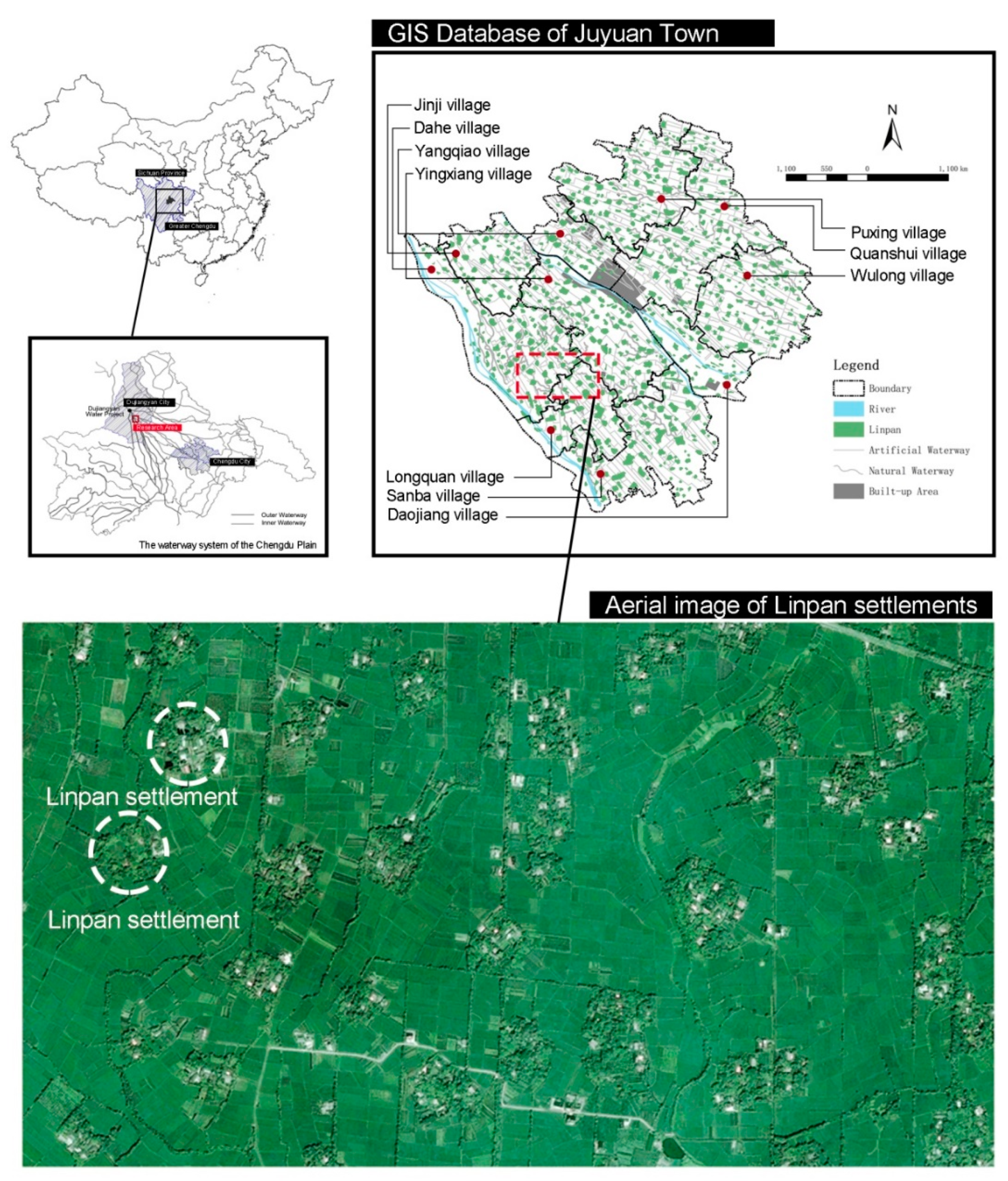
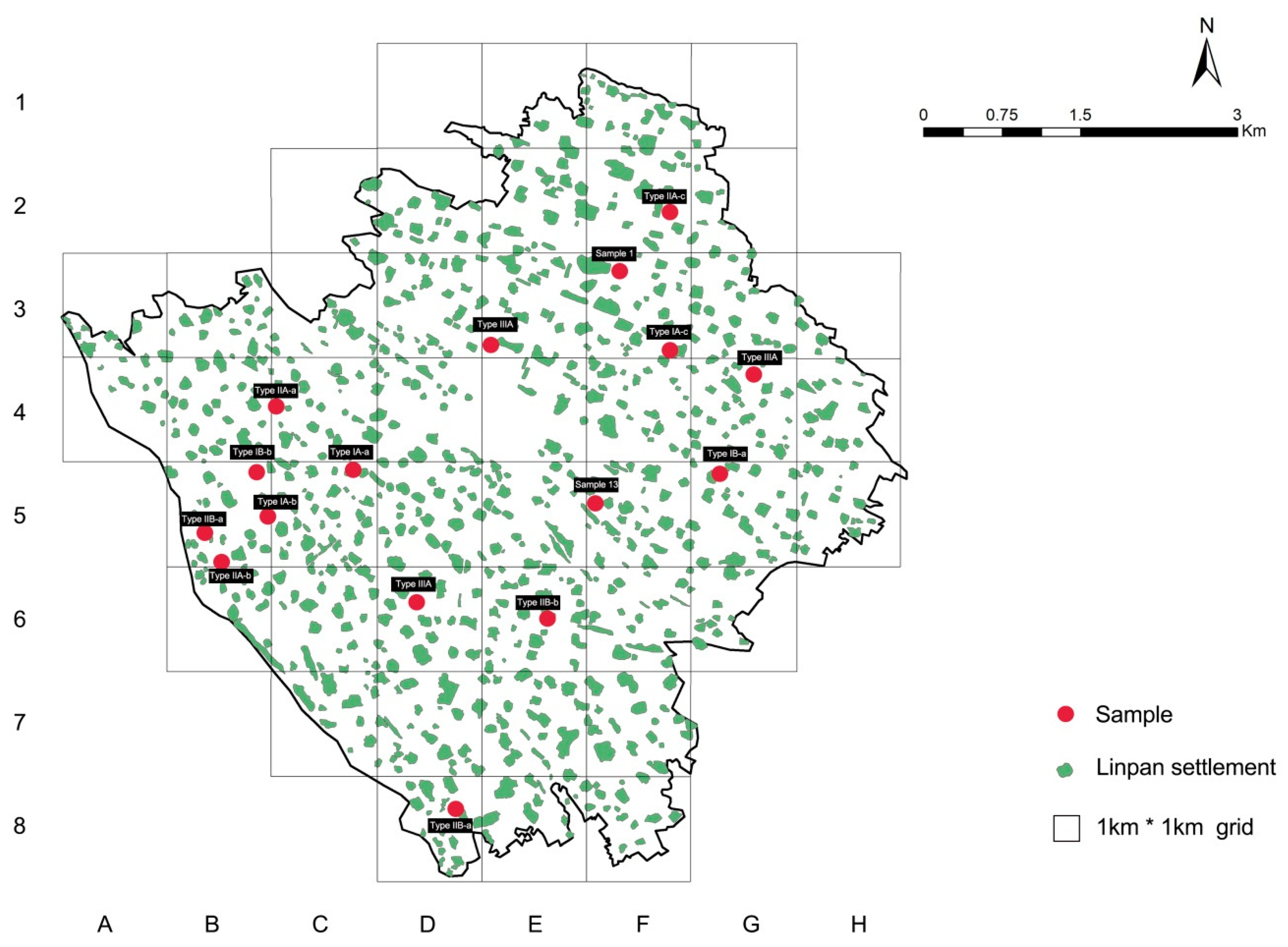
At more than 2300 years old, Western Sichuan’s Linpan settlements date back to the ancient civilization era and took shape over a long period of immigration [21]. They are widely distributed across southwestern China, especially in the fan-shaped alluvial Chengdu Plain in western Sichuan Province. Starting from the Dujiangyan Irrigation Project, the Chengdu Plain’s irrigation areas are flat, except for a northwest to southeast slope with an average gradient of 3–10%, where the relative surface relief is less than 20 m, and annual rainfall is about 900–1240 mm. The superior topography and abundant water sources form a highly networked gravity irrigation system. This study examines Juyuan Town in Dujiangyan City to scrutinize the sustainable development of cultural landscapes in rural parts of the Chengdu Plain (Figure 1). Juyuan Town covers a total area of 34 km2 and has 10 administrative villages; the land cover is mainly composed of farmland, with rice and rapeseed as the chief agricultural products. Compared to 2005, by 2018, there were approximately 515 Linpan settlements in the region under the town’s jurisdiction, with a decrease of 273 in the total number and 19.87 ha in terms of area. Juyuan Town is selected for the following reasons:
- Juyuan Town is in the core zone of Dujiangyan City’s elite irrigation district—it has a rich cultural history, which is of great significance for understanding the evolution of Linpan settlements. Moreover, the town is the first through which gravity irrigation water flows, making it a good model for examining the relationship between human activity and the natural environment;
- In China, most rural areas are underdeveloped, and relevant information or data is complicated to obtain. However, since the Wenchuan earthquake in 2008, we have conducted a continuous follow-up study on Juyuan Town for nearly ten years. The previous research findings are very beneficial to the in-depth study of the area and similar rural areas;
- It is a key municipality in Dujiangyan City (Key towns are geographically big with high populations, well-developed economies, and complete supportive facilities. Their construction effectively balances the distribution of relocated rural residents, and reduces the population burden on large cities), located in an urban-rural intersection. The town is facing the pressure of urbanization, as well as the threat of the destruction of traditional cultural landscapes. Thus, it is urgent that the sustainability of local cultural landscapes be investigated.
2.2. Defining Linpan Cultural Landscape
Based on the definition of CO Sauer, the cultural landscape has both time and space characteristics, which is the result of the continuous influence of human culture on a specific regional environment. Each traditional cultural landscape expresses a singular local spirit that helps shape its identity [22]. Historically, the Linpan settlement system in the western Sichuan Plain has changed with society’s prosperity. During the pre-Qin period, the indigenous people of Laos began to establish settlements in the Chengdu Plain. The construction of the Dujiangyan Water Conservancy Project during the Qin and Han Dynasties stimulated the improvement of the agricultural and forestry management structure, and Linpan’s living pattern gradually formed. During the Tang and Song Dynasties, with the prosperity of the economy, the Linpan model continued to improve and experienced large-scale expansion. In the late Ming and early Qing dynasties, due to war, natural disasters, and social and economic turmoil, the population of the western Sichuan Plain sharply reduced, and most of the Linpan settlements were damaged or uninhabited. In the late Qing Dynasty, with the gradual recovery of population and social reconstruction, the Linpan settlements cluster became more stable and has sustained itself until now through the process of constant adjustment and adaptation to the environment [21]. In terms of space, the Linpan settlement is geographically unique. The Linpan settlements are spread over the vast plains of western Sichuan with the surname (clan) as the settlement unit. With extensive farmlands, the structure of the Linpan settlement looks like a green island. It serves as a carrier for the harmonious symbiosis of humans, plants, and animals. It is a typical natural village (Figure 2). To date, although the Linpan settlements have not been uniformly defined in the academic community, scholars with different research perspectives have described them in various ways, such as social units with cultural symbols and use value (Duan); composite, rural scattered settlements that integrate human life, production, ecology and land (Fang); and rural living units that combine agricultural production and family relations (Chen) [23,24,25]. These definitions all focus on social relations, landscape patterns, and ecological structures. In addition, many scholars, such as Zhang, have proposed the concept of the Linpan system, arguing that it is a complete settlement layout representing the semi-natural, semi-artificial wetlands of the Dujiangyan irrigation region [26]. Japanese expert Ishikawa asserts that the Linpan system should be regarded as a remarkable historical and cultural landscape heritage [27]. This study proposes that the Linpan system consists of scattered communities, which are composed of a number of individual (Linpan) settlements. Such settlements are independent living spaces in rural habitats, dispersed throughout the Chengdu Plain. A Linpan community refers to a whole body of spatial continuities comprising river systems, road networks, fields, and settlements of a certain size, which embody a lifestyle with local characteristics (referred to as “the Linpan mode”).
2.3. Methodology
The concept of the cultural landscape is rooted in geography and was first put forth by German geographers in classifying fields, villages, towns and roads. Later, it was promoted as the focus of geography research by American geographer Sauer, who also proposed the “morphology of landscape,” advocating for the use of actual observation of the surface landscape to study geographical phenomena [28]. The study of cultural landscapes initially focused on the description and observation of performance [29]. With the deepening of people’s understanding of the landscape and the mutual influence of various disciplines, quantitative analysis methods such as computer technology and 3S have gradually achieved fruitful results in the study of dynamic landscape characteristics [30]. This study mainly uses the traditional geography description and classification method, combined with modern computer-aided technology, to systematically study the evolution process of Linpan culture landscape. The research methods include typology and comprehensive induction, field research, and case analysis. Based on systematology, this study draws on a large number of theories on cultural landscapes to identify and categorize the landscape features and evolution types of Linpan settlements. Finally, based on the idea of demand in defining sustainable development, the factors affecting landscape change are interpreted. Typology theory is an essential theoretical support for the study of Linpan landscape morphology, which is not just an epistemology that facilitates the understanding of the intrinsic formation mechanism and formal meaning of historical rural settlements; it is also used to guide design based on rational treatment of traditions as a prerequisite and adaptation to the requirements of new lifestyles [31]. A typological approach allows us to extract the structural components of the Linpan system, grounded in an analysis of existing settlements, and to speculate on the morphological transformation of characteristics in different contexts.
With respect to technology, this study establishes a spatial geographic information database of Juyuan Town between 2005−2018, and employs the spatial analysis module of a geographic information system (GIS) to conduct an in-depth examination of the Linpan system’s spatial attributes, layout, and structural changes. Moreover, the study uses 1 km × 1 km grid cells as the unit of analysis to statistically count and summarize morphological variation features of the town. The boundaries of the Linpan system are determined by extracting historical remote sensing images from Google Earth. Correlation analysis of spatial patterns is mainly based on 2005 data, as data after 2008 are largely subject to anthropogenic influence. The data used in the study are derived from relevant information provided by government departments (such as statistical data, planning documents, and local chronicles), as well as details obtained from field surveys (such as mapping, observation, interviews, and transcripts).
3. Case Study
3.1. The Hierarchy of Linpan Settlements
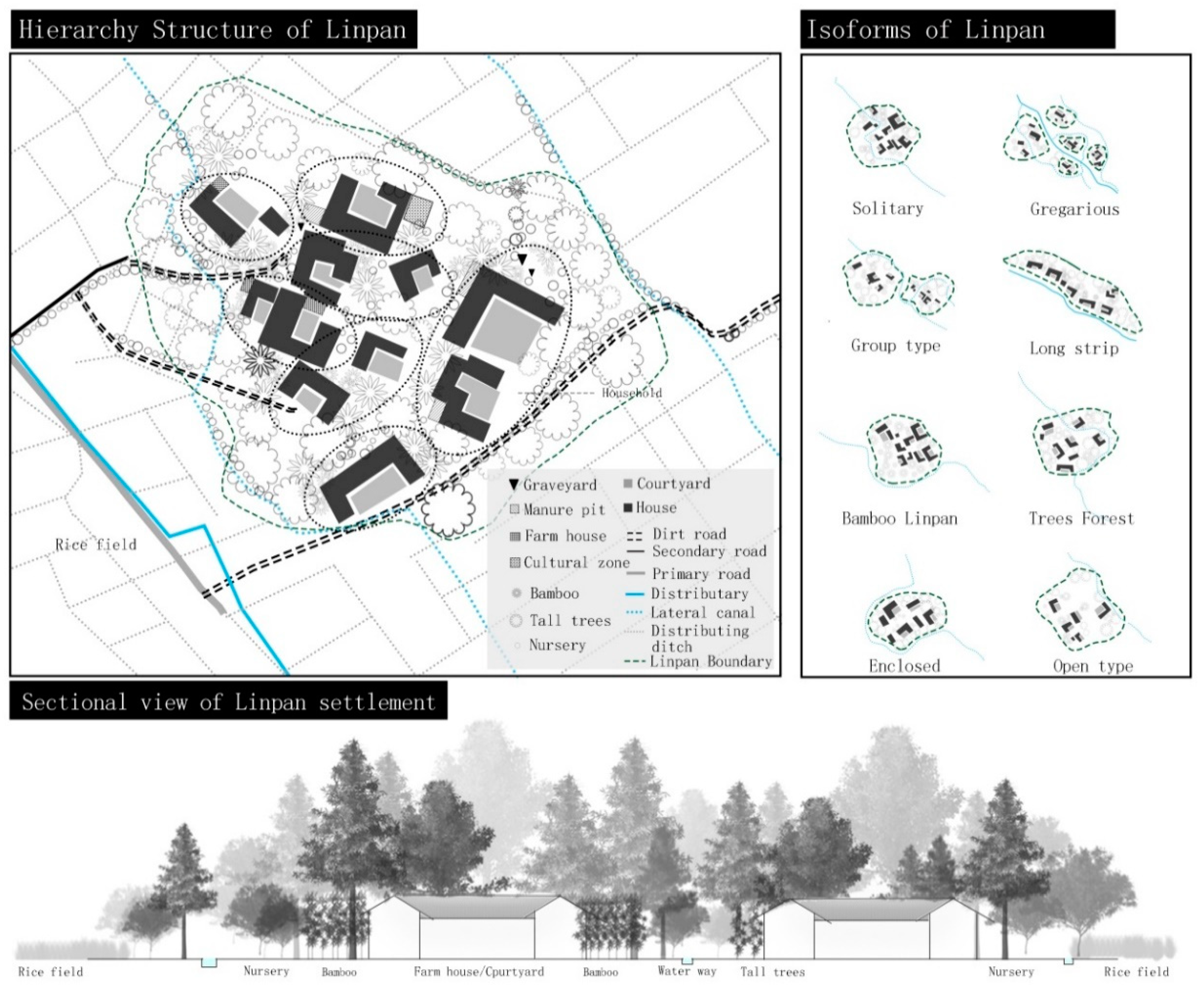
Linpan characteristics are based on two aspects: Spatial structure and human culture [32]. As the lowest level of spatial structure regarding human settlements in the Chengdu Plain, the Linpan system consists of numerous, widely distributed units, which signify the most fundamental building block of life [33]. As shown in Figure 3, each unit consists of five elements (house, courtyard, forest, farmland, and waterway) and is comprised of tens, sometimes dozens, of households. Water channels surround or pass through most Linpan units. The houses are concealed by tall trees (e.g., nanmu and cypress) and low forms (i.e., Omei Mountain and bitter) forms of bamboo, creating a tranquil scene where the inhabitants rest in the forest and work in the fields [34]. The boundaries of forests outside the Linpan settlement are often seen as criteria for defining their scale. Due to the different needs and habits of each family and the limitations of environmental conditions, Linpan settlements present a variety of features with the same hierarchy, but different shapes. For example, in the densely populated areas of the irrigation water system, there are more concentrated Linpans, and the Linpan settlements on both sides of the river are mostly long strips. As for humanistic value, the Linpan system offers a sustainable farming lifestyle that integrates humanity and nature, life and production. It relies and acts on the land, representing a local ideology of “harmony between man and nature” according to Taoist philosophy. Since antiquity, Linpan settlements have been dispersed throughout the fields, with each unit given a surname (based on patriarchal clans); the Linpan system is typical of naturally formed villages [35]. Over the long term, the Linpan system has been a vehicle for local farming culture and served as evidence of farming civilization. Embodying ancestral wisdom, this self-contained, composite agriculture and forestry ecosystem, founded on a small-scale peasant economy, has very high ecological, cultural and aesthetic value [36].
3.2. The Spatial Structure of Linpan Settlements
3.2.1. The Distribution of Linpan Settlements
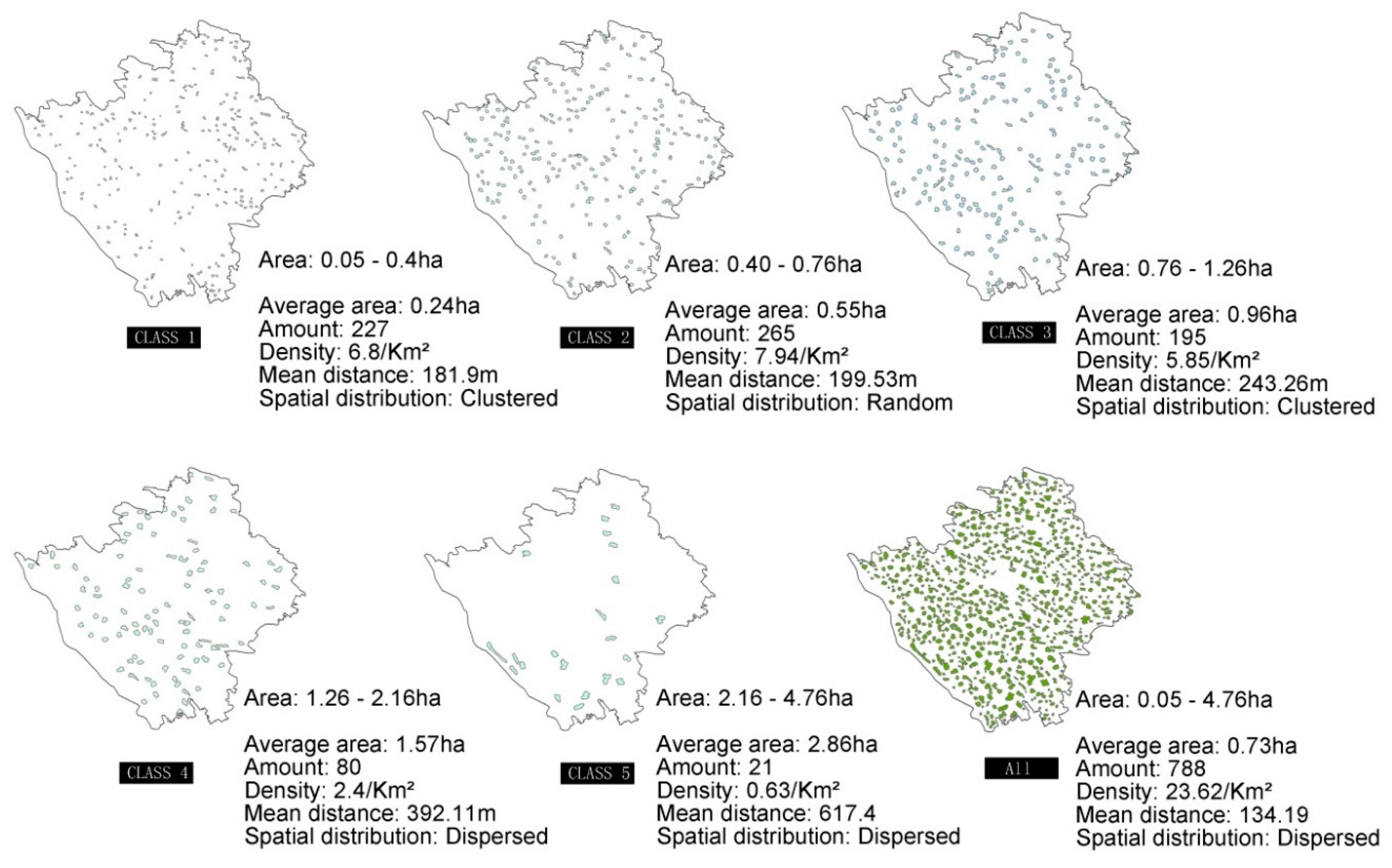
Firstly, based on the GIS database, the area of each Linpan settlement in Juyuan Town was calculated and divided all of them into five grades through natural break classification method. Then the spatial pattern of Linpan settlements in different scales were analyzed and statistics respectively, this step is mainly based on the use of the Average Nearest Neighbor tool in ArcMap software, the calculation results are shown in Figure 4: The settlements in Juyuan Town have an average area of 0.73 ha and are small and medium-sized (less than 1.26 ha), accounting for 87% of the total number of settlements. The density of settlements in the town’s jurisdictional region is about 23.62 units per km2 (settlements larger than 2.16 ha in size are quite rare in most areas), and the average distance between adjacent settlements are about 134.19 m. The smaller the area, the closer the distance between adjacent Linpan settlements, and the spatial distribution is often characterized by agglomerated distribution. Conversely, the larger the area, the more scattered or random the distribution. On the whole, Linpan communities show dispersed distribution patterns in terms of spatial structure, and are characterized by dynamic evolution in the sequence of “aggregation, randomization, and dispersion” corresponding to the serial stages of their “occurrence, development, and stability.”
3.2.2. Relationship between Life and Production Space
Initially, most vernacular landscapes were created by farmers to organize their land better, and ensure their survival [37]. The Linpan system, containing typical farming settlements, provides farmers with an ideal environment, wherein production takes place on cultivated land along the periphery. The relationship between living and production spaces is reflected in the tillage radius, which refers to the distance from a settlement to cultivated land. The buffer analysis method is commonly used to analyze the radius of the cultivated land. Theoretically, in a specific area, when the area of the buffer generated by a specific radius is equal to the actual cultivated area, the radius of the buffer of the settlement is equal to the farming radius. At the same time, the ratio of the buffer area to the cultivated area can indicate farming pressure [38]. In this section, the evaluation unit is first determined by the boundary of the administrative division of the village area, and then the peripheral buffer range of different scales is established based on the Linpan boundary in the database (Table 1). The buffer area in each unit is counted using layer superposition in ArcMap software. Finally, the farmland pressure coefficient is calculated using the attribute field of each unit layer to link the corresponding cultivated land area data (Table 2):
In the formula, is defined as the cultivated pressure coefficient of the evaluation, which represents the rural labor carried out on the cultivated land in the evaluation unit (village); is defined as the buffer area of the Linpan settlement in the evaluation unit; and refers to the cultivated land within the unit. Tillage radius affects the residential layout in rural zones, serving as an important reference for exploring the human-land connection in farming areas and assessing the layout rationality of future protection planning [39].
The findings demonstrate that 50–60 m is the optimal tillage radius of a Linpan settlement in Juyuan Town (Table 1). Within this range, the tillage pressure coefficient of each village is close to 1, suggesting that this is the best spatial distribution for rural settlements and cultivated land in the process of natural adaptation (Table 2). That is, there is neither excessive labor nor a large amount of wasted arable land, which reflects the environmental adaptation of the Linpan-based residential mode according to different scales of land use.
3.3. Type Conversion
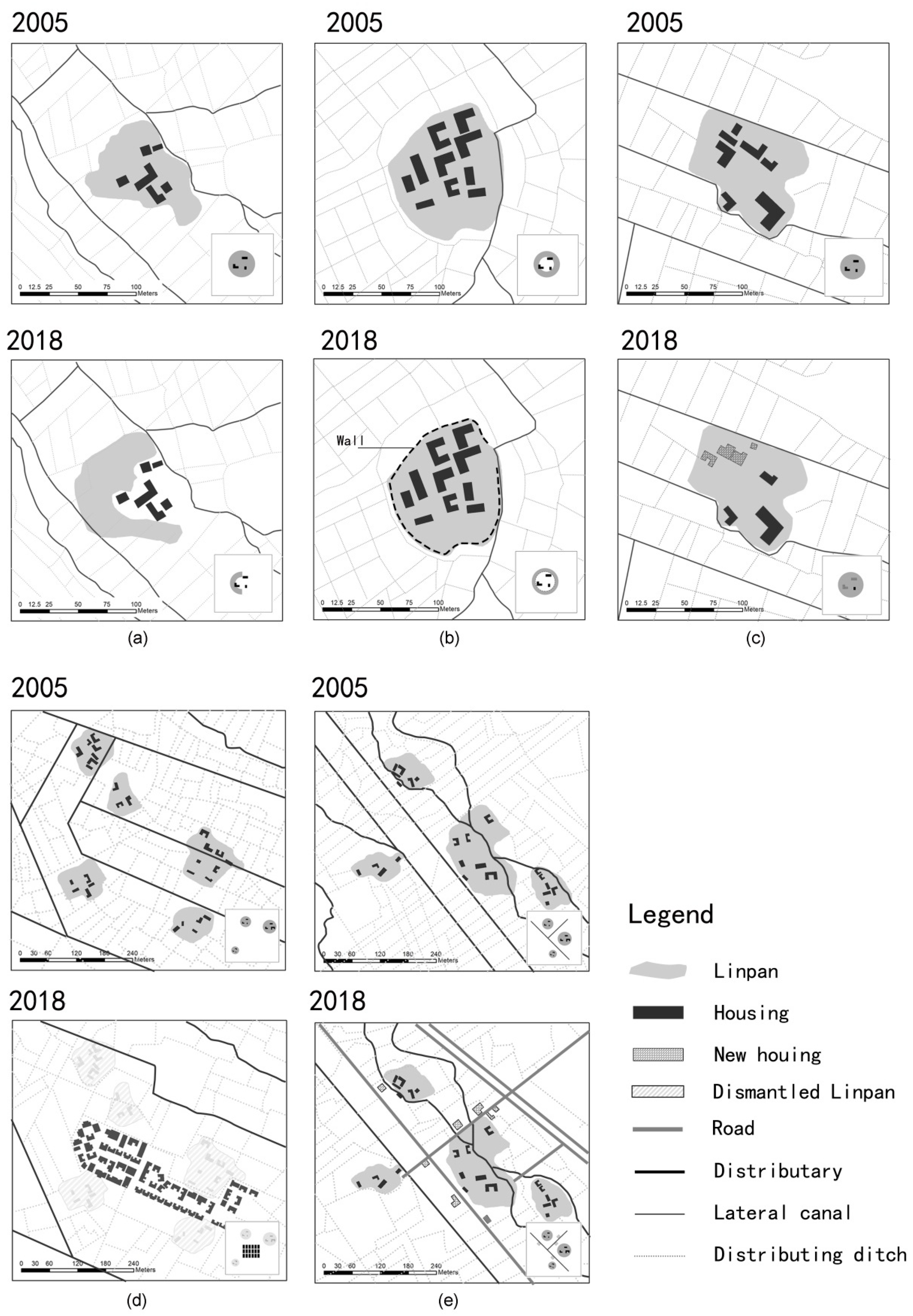
By constructing a spatial geographic information database in rural areas, it is possible to quickly identify changes in the spatial patterns of a given area over a period of time. Cultural landscapes are complex cultural phenomena that generally result from human activities acting on the earth’s surface; they are composed of the natural environment, residential architecture, transportation, art, and people. Meanwhile, shifts in spatial patterns reflect long-term interactions between the landscape and the natural environment, the social economy, and historical development [40]. The basis for the classification of Linpan dynamic evolution is the morphological identification and field research (including questionnaires, interview minutes, phenomenon descriptions, etc.) of geospatial databases at two different time points. According to the overall system-to-local rules of the system theory, the dynamic changes of the Linpan settlement are summarized into three first-class categories of internal change, morphological change, and external landscape change, as well as the original site renewal, relocation, primary forest expansion, economic forest planting, municipal infrastructure, and social foundation. The facility has six sub-categories, and the different spatial representations of each sub-category are illustrated based on the typology performance method. The selection of typical samples is shown in Figure 5. In addition, based on interviews with 114 households in Juyuan Town and the results of several rounds of expert consultation, this paper used the demand hierarchy theory to mark the spatial shape change of Juyuan Town. For example, the demand for basic life, agricultural production, or non-agricultural supply is marked as survival demand; the outstanding desire for the development of individuals or local economic development and social development is marked as development demand; and people’s spiritual needs, such as cultural heritage, and environmental protection, indicate quality demand. The classification description is shown in Table 3.
3.3.1. Type I: Internal Changes
Internal changes refer to alterations of the residential environment, as well as the structure and function of each individual Linpan settlement over time. Two modes are involved: On-site updates and off-site migration:
- Spatialreplacement (Figure 6a). More open space is obtained by reducing the number of trees to meet farmers’ daily living needs (such as parking, leisure, and production). This reflects the self-regulation and lifestyle of local residents in relation to the residential environment, based on their customs and behavior when adapting to modern life.
- Functionalreplacement (Figure 6b). Forests outside Linpan settlements provide shelter from the wind and protect the soil. At present, they are gradually being replaced by cement walls or iron gauze, demonstrating improvement in residents’ security awareness, promotion of land tenure awareness (i.e., boundaries), and greater concern about personal privacy [41].
- Old-for-new replacement (Figure 6c). With the enhancement of farmers’ living standards, many traditional residential buildings in western Sichuan cannot meet the needs of modern living. Numerous old buildings in Linpan settlements have been demolished, with new houses erected on site. After the 2008 earthquake, countless old buildings were damaged to varying degrees. The post-disaster recovery and reconstruction resulted in the construction of multi-story (2–3 stories) single-family buildings with a large number of brick-concrete structures (verified through the field survey). To a large extent, this shows that improved economic status leads to changes in rural scenery. Off-site migration consists of two modes: Centralized building (at a different site) versus construction by residents (on their own).
- Newrural communities. As presented in Figure 6d, several neighboring Linpan settlements are merged into a group, while uniformly placing the original residents in newly built rural communities in response to the “Three Concentrations” policy (The “Three Concentrations” policy is the fundamental approach for coordinating urban and rural growth, promoting urban-rural integration, and solving the “three rural issues.” Industry is concentrated in centralized development zones, farmers are placed in towns and new kinds of communities, and the land is used for operations on a moderate scale) regarding land readjustment in rural areas.
- Off-site construction. As shown in Figure 6e, when Linpan settlements’ size and relationship to the land are exploited to the maximum extent, the residents living there will build new homes around the original settlement, mostly 2–3 story, brick-concrete, single-family buildings, similar to those in type IA-c. The selection of the location for the new houses is no longer predicated on whether the new areas have well-developed river systems. Instead, the primary consideration becomes whether the new homes are in close proximity to roads.
3.3.2. Type II: Morphological Changes
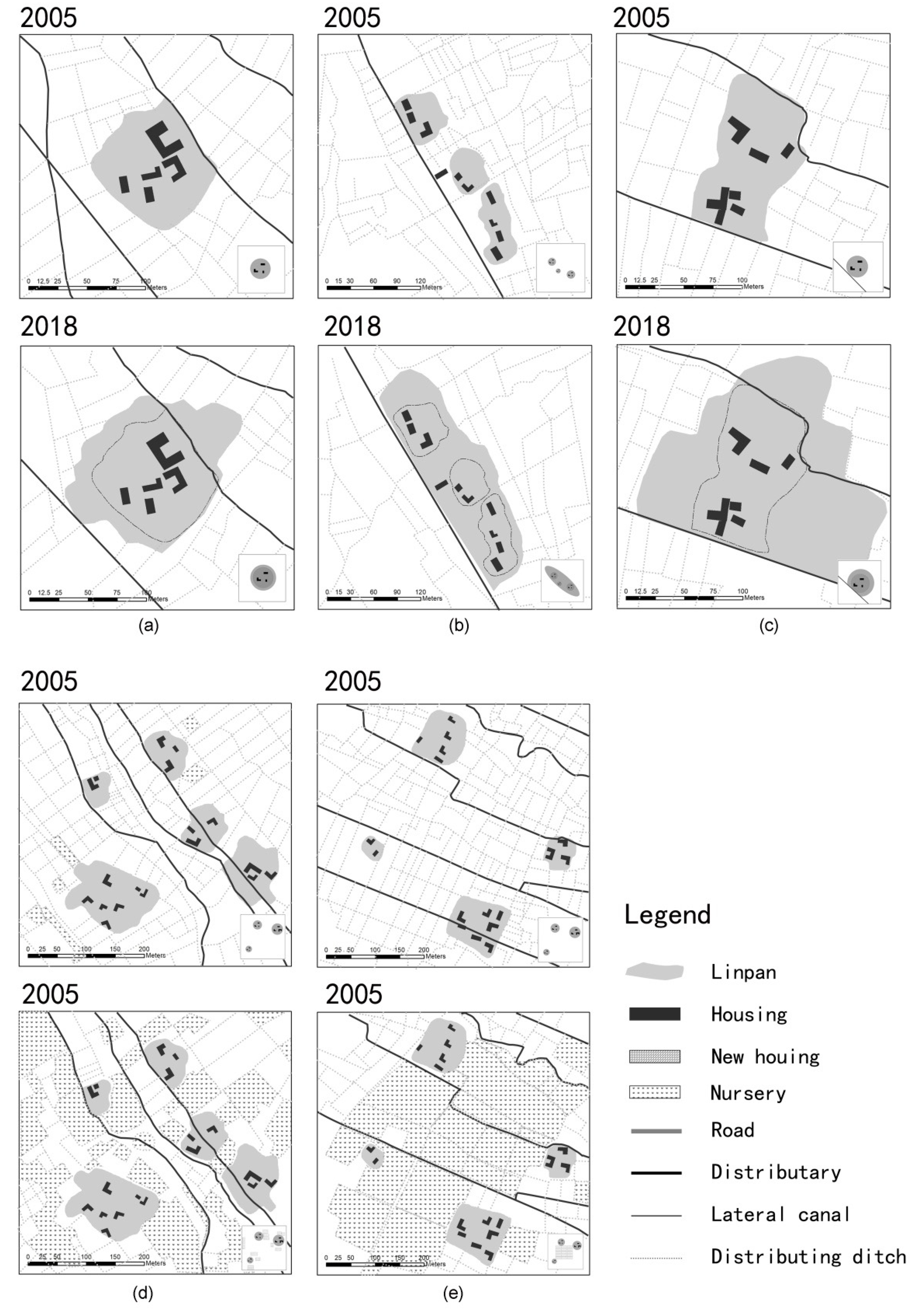
As presented in Figure 7a–c, morphological changes consist of three modes: Unconstrained expansion, joint expansion, and constrained expansion:
- In unconstrained expansion, the extension of the boundary is free from apparent environmental constraints. Afterwards, the morphology is similar to the original one. The expansion can be one of two types: The growth of native trees or the planting of new seedlings;
- In joint expansion, adjacent Linpan settlements are gradually integrated into an overall body. Linpan settlements established through joint expansion are strip-shaped and contain two or more family clans with different surnames;
- In constrained expansion, due to geographical obstacles (such as roads, canals and rivers), the boundary undergoes irregular extension. The Linpan settlements are unevenly distributed, and the shape after the expansion is inconsistent with the one from before.
Furthermore, the transformation of land-use types is a direct factor affecting changes in rural landscapes and has clearly identifiable spatial traits. As exhibited in Figure 7d,e, the market economy has triggered industrial structural adjustments, while the planting industry (of economic forests) has brought high economic benefits to farmers, with such market-driven trends becoming increasingly popular [42]. In Juyuan Town, economic forestry planting covers almost every village and can be divided into two types: Large-scale and non-scale. Large-scale planting is primarily carried out by several adjacent Linpan settlements to jointly manage an area and undertake forest planting. Large-scale planting is the uniform planting type, marked by regular borders in the planting area. In contrast, non-scale planting in economic forests mostly indicates spontaneous planting by some Linpan owners in the open space surrounding their own settlements. The forest types are not uniform, with the entire planting area showing a broken, patch-like pattern in the absence of an obvious spatial order.
3.3.3. Type III: External Landscape Changes
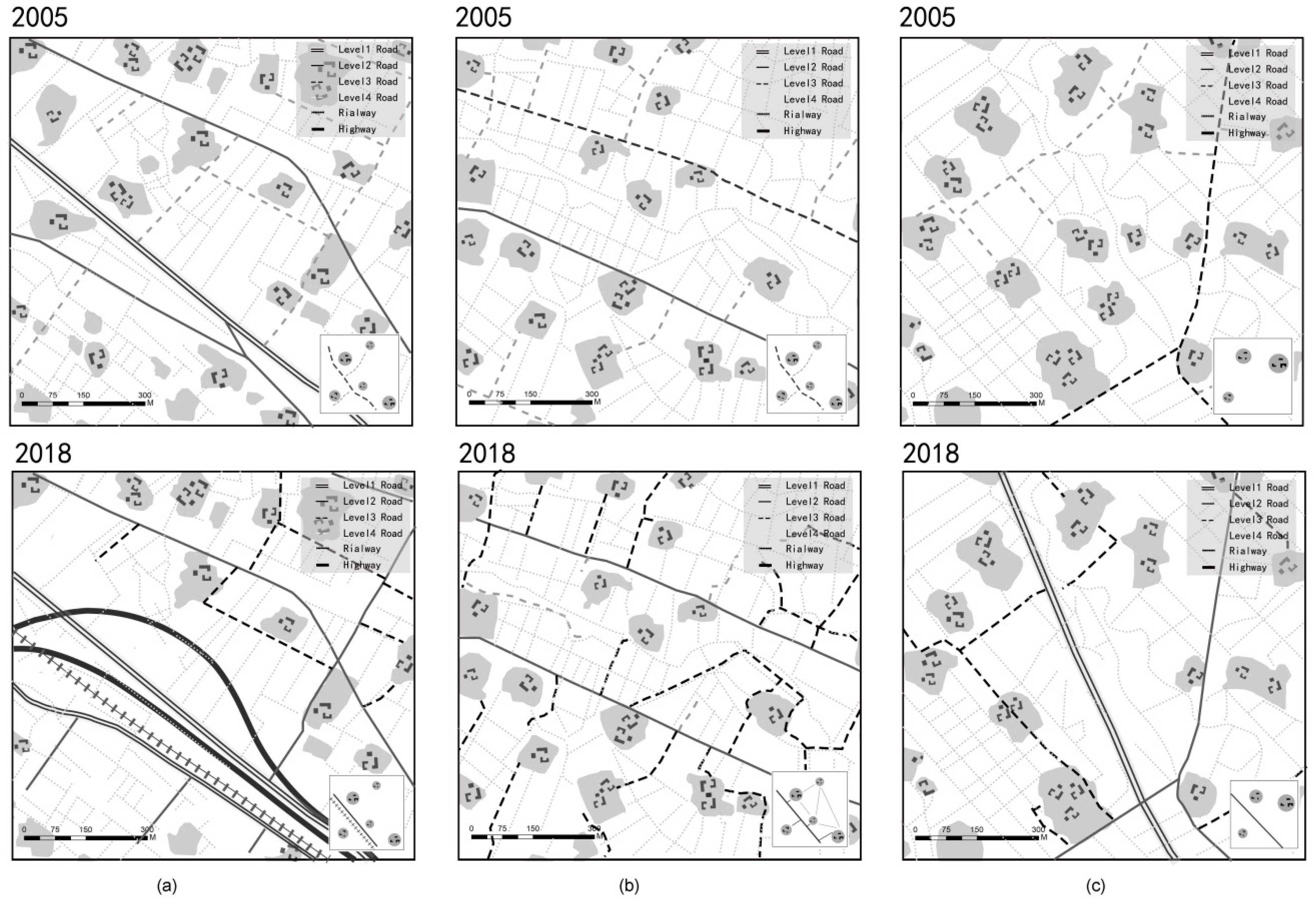
With the development of Juyuan Town and the surrounding municipalities, residents’ demands for resources have become more diverse. The construction of supportive facilities necessary to meet daily needs has broken the spatial integrity and continuity of the original rural landscape. In particular, the layout of the transportation network has divided the continuous landscape matrix, and different kinds of land have been assigned different functions. External landscape changes are mainly reflected in the impact of urbanization-related construction on the landscape matrix, with roads and other facilities being built. There are roads with three purposes (Figure 8): New forms of transportation facilities (for example, two additional highways and one railway have been built in the past decade, as shown in Figure 8a); to enhance internal connections (Figure 8b) (i.e., the accessibility of Linpan settlements); and new village- and town-level roads, as well as upgrades made to them (Figure 8c). The construction of new facilities implies social infrastructure besides the addition and improvement of municipal infrastructure, such as cultural and leisure facilities (e.g., Western-style concert venues, cultural squares, activity centers, and resort hotels), and educational and medical facilities (e.g., Bayi High School, Qiyi Middle School, Sichuan Business and Technology Vocational College, general hospitals). In addition, some commercial organizations (e.g., automotive service companies, horticultural fields, and machine manufacturing companies) are slowly being introduced as the supporting infrastructure continues to be improved.
4. Results and Findings
4.1. Change Statistics
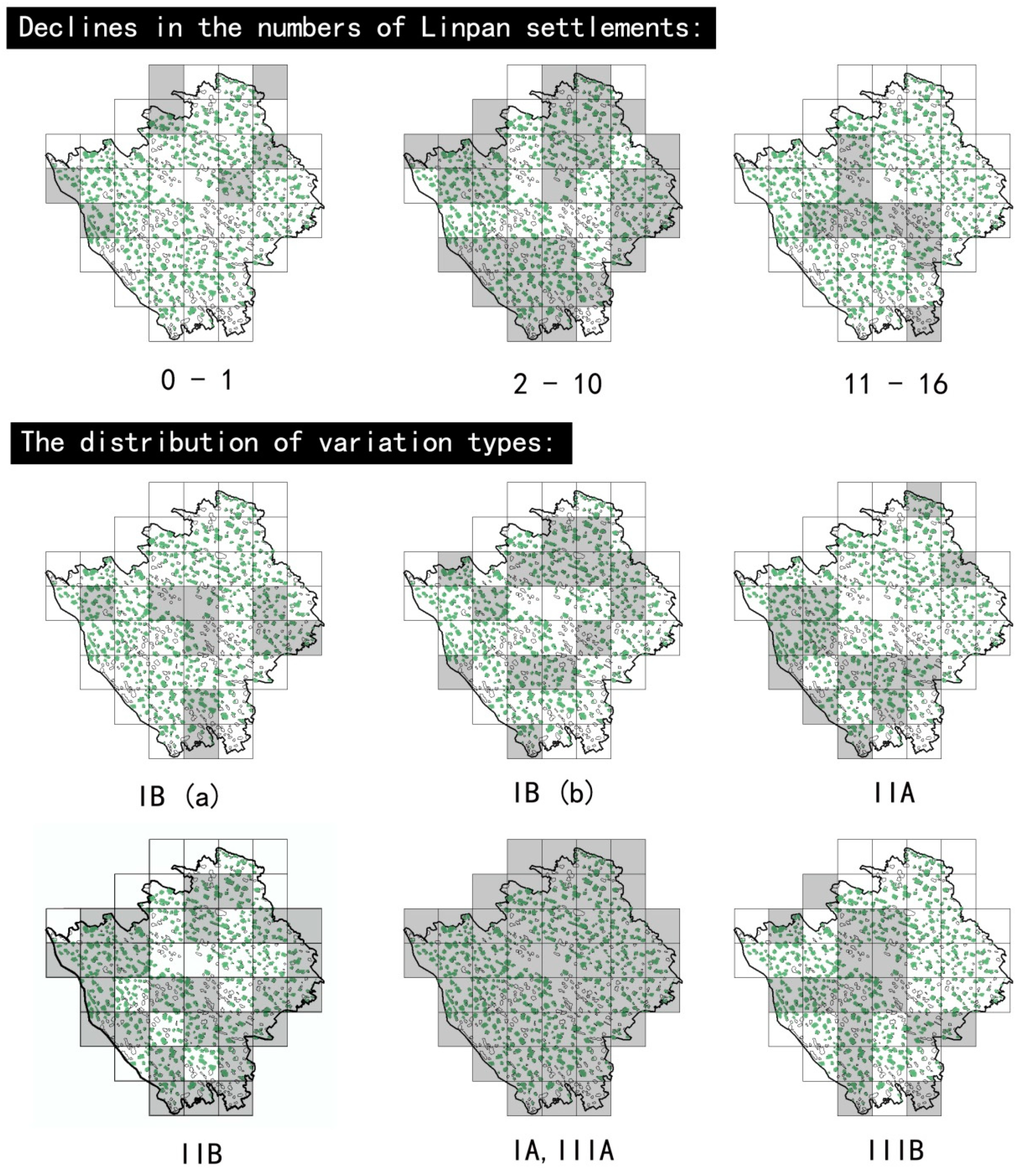
From 2005 to 2018, the total number of Linpan settlements in Juyuan Town decreased by 273, amounting to an average loss of six settlements per square kilometer. As shown in Figure 9, correlation analysis of the various types of Linpan settlements and their reduced areas, with respect to the spatial locations where the reduction occurs, reveals seven statistical grid cells each that have experienced a change in the quantity of Linpan settlements by one or less than one, largely in the border zone within the central urban area, with the city’s surrounding green belt designed to control disorderly expansion and to protect the rural cultural landscape in the restoration and reconstruction process following an earthquake [43]. By contrast, areas—where the number of Linpan settlements has decreased by more than ten—are chiefly concentrated in the south of the built-up zone, indicating that the urban construction of Juyuan Town tends to extend southward. In most areas, the number of Linpan settlements was approximately ten, which also reflected the fact that the broad area of Linpan’s traditional settlements was reduced. In other areas, the number of Linpan settlements was within ten. According to the change test, the main external material conditions that lead to a decrease in the number of Linpan settlements are the construction of roads (e.g., public roads, highways, and railways), the development of towns and new rural communities, and improvements in living service facilities (e.g., hospitals, schools, factories, and power stations). This new construction requires more land. The expansion of land for such purposes in the town is the most direct cause of the decline in the number of Linpan settlements.
The grid statistics reveal that type IIIA (municipal infrastructure construction) and type IA (on-site renewal) are the most frequent landscape changes in the study region. Second, type IIB (economic forest planting) is a factor causing apparent visual shifts in the overall landscape pattern. A large number of trees planted for their economic value has destroyed the original landscape matrix, making the landscape discontinuous. Such fragmentation leads to a decrease in regional identity and sense of belonging [44]. Changes in settlement morphology resulting from the growth of the Linpan settlements’ native and secondary forests (type IIA) are also common. Moreover, with respect to the geographical positions of these transformations (Figure 9), the construction of new rural communities (type IB) is largely concentrated in the center of town, where there are well-developed transportation facilities with convenient living conditions. Farmers’ self-built homes are mostly distributed along both sides of the roads not far from the above-mentioned, large Linpan settlements. The survey and interviews reveal that when the number of people living in a Linpan settlement increases, people will build new houses in the adjacent open space (while in the past, a new Linpan settlement would be erected, rather than a new, single-family home). This embodies a randomized, jump-like expansion mode. Moreover, the construction of new and modern homes is preferentially conducted close to roads rather than river systems. This reveals that the traditional functions of the Linpan settlement have changed, and their farming culture is also disintegrating.
4.2. Discussion on Demand and Sustainability
The World Commission on Environment and Development defines sustainable development in the book Our Common Future (Brundtland Commission) as “development that meets the needs of today’s people without compromising the ability of future generations to meet their needs.” Moreover, it points out that sustainability includes the two concepts of “needs” and “restriction” [45]. The results of this study indicate that the needs of Juyuan Town’s residents are transitioning from those of survival to those of development. Such growth, alongside the hierarchy of needs, is engendering changes in the cultural landscape of Juyuan Town’s Linpan community. For example, types I (IA,IB-b) and II (IIA) tend to meet survival needs. The residents’ new housing locations also indicate that the prerequisites for choosing a home have shifted from the convenience of production to the convenience of living. Meanwhile, types II (IIB-a) and III (IIIA) meet development needs. The layout of a large number of transportation networks and the construction of new rural communities represent a trend toward urbanization. Type III (IIIB) shows that people are striving to obtain more education and entertainment resources, improve living standards, and pursue a higher quality of life.
The differences in the categories of need have led to the spatial differentiation of rural landscape patterns. The more categories of need there are, the higher the requirements for landscape diversity. Meanwhile, the changes in the level of demands have caused the time differentiation of landscape patterns. For instance, the closer to the built-up area of the town center, the richer the various types of land, and the more quickly residents’ needs can be met, which leads to a desire for another level of resources. The expansion of residents’ needs, along with the hierarchy of needs, is the intrinsic driving force that affects the sustainability of the Linpan cultural landscape. Interviews reveal that population in the settlements is dominated by the elderly, as most young people leave to seek work: This means that the main human resources for protecting Linpan culture are constantly being lost. Although the basic structure of the Linpan settlements under investigation has remained intact, some are gradually showing signs of “empty nests”, due to the neglect of management. In addition, changes in transportation patterns have a large impact on the land of the studied region. The arrangement of transportation networks accelerates the connections and energy exchanges between the interior and the outside world, while the modernization process of rural cultural landscapes has a high degree of synergy with the construction of transportation infrastructure.
According to this study, the sustainable development of traditional cultural landscape should have traceable spatial continuity, regional uniqueness, cultural accumulation, and landscape inheritance. The discussion of the sustainability of cultural landscape mainly refers to the quality requirements in the future development process, rather than the pursuit of the maximum number of regional resources or similar landscapes. The cultural landscape is a real reflection of personal lifestyle and an expression of how people meet their own needs at all levels. The cultural value of the traditional cultural landscape lies in the fact that the environment records and reproduces the methods of people’s survival under previous material technology and thinking in the form of carriers. Then, with the progress of society, economic development, and the change of value system, traditional culture and lifestyle are gradually detached from modern society. Therefore, to achieve sustainability, traditional cultural landscapes must continue to meet the expectations of people’s needs according to different levels of survival, development, and quality of life. For example, according to the case study, at the level of basic survival needs, the impact of people on the landscape is mainly due to the creating of residences, using the most inexpensive choice. In this respect, the maintenance of cultural landscape depends chiefly on the realization of science, that is, rapid advances in technology. From the perspective of development needs, once basic needs are guaranteed, people begin to consider physical renewal and optimization. At this stage, the impact of human activities on the environment essentially comes from the social environment and personal feelings. Here, the cultural landscape can sustain itself if the traditional functions of the landscape are balanced with contemporary needs. Finally, the relationship between the demand for quality of life and cultural landscape sustainability lies in the use of traditional values and aesthetic concepts to combine the material, technology, and culture of the time to establish a new cultural philosophy. To sum up, the sustainability of cultural landscapes does not mean that the traditional landscape is preserved and continued in its entirety; rather, it is adapted to social life, is people-centered, and can be organically inclusive and continuously updated in future development.
5. Conclusions
Linpan settlements are distributed as independent living units in the vast rural area of the Chengdu Plain. During conventional planning, the integrity and continuity of the Linpan community often become fragmented. As a result, traditional Linpan farming settlements have failed to receive effective protection and attention in the planning preparation process. This study establishes a spatial geographic information database of Juyuan Town. Through the application of the hierarchy description of the settlement system and the description of spatial features, the internal logic of the spatial layout of the traditional settlement culture landscape is expounded from three aspects: Hierarchy, geographical layout, and type conversion. Using the typology theory, the Linpan settlement group of Juyuan Town was used as a case study to demonstrate the dynamic evolution process of agricultural settlements in the western Sichuan Plain. Otherwise, the Linpan settlement landscape type conversion process was described in stages based on the demand hierarchy theory in sustainable development. The findings were as follows.
The Linpan settlement in Juyuan Town has a decreasing trend as a whole. Approximately six traditional Linpans per square kilometer have been demolished in the past decade. The new rural settlements in the region do not substantially retain the typical characteristics of the traditional settlements. The degradation of the Linpans’ traditional functions and the changes in people’s contemporary life concepts are the root causes of the abandonment of Linpan settlements. Historically, although these settlements have been highly self-sustainable and capable of organic self-replication and renewal, in the process of transformation and evolution, residents and settlements often have a unique symbiotic relationship of separation and integration. The differences in the level and type of need affect the changing trends of the landscape, and growth in terms of the hierarchy of needs influences the speed and magnitude of landscape transformations, thus resulting in the continuous reduction of the integrity, continuity, and recognizability of the landscape. Additionally, the development of the social economy will inevitably introduce higher requirements for the construction of rural areas. The construction of rural infrastructure not only promotes internal convenience, but also strengthens energy exchange with surrounding areas; however, it is also a double-edged sword. Due to the lack of awareness of traditional culture in the early stage, and the lack of inheritance, regional culture cannot resist the erosion from a foreign culture. Coupled with the dilemma of the younger generation migrating to urban environments and the aging of the local population, the leading human resources that protect and inherit the Linpan culture are continually being lost with the laying of the transportation network.
Landscapes have always been subject to alterations in order to better adapt to evolving social needs. It is necessary to correctly grasp the harmonious human-nature relationship in the Linpan farming settlements of western Sichuan plain, to explore the potential for the sustainable development of cultural landscapes, and to strengthen the understanding of rural cultural landscapes, which is an inevitable requirement to transform natural environment. The sustainable development of western Sichuan’s Linpan communities depends on the strategic measures of spatial planning. According to this study, sustainable development of cultural landscape is an original implementation path that takes protection as the main factor and development as a supplement to maintain the identities, continuity, authenticity, and outstanding cultural value of the cultural landscape. House, courtyard, forest, field, and waterway are the five critical elements of the Linpan settlement hierarchy, which are the essential factors to ensure the sustainability of cultural landscape construction and landscape culture communication. In addition, the Linpan community appears to be in a random, but orderly spatial order, and these universal commonalities within the Linpan settlement are sustainable landscape inheritance characteristics. The hierarchy of needs to examine the spatial evolution of Linpan settlements’ landscapes is adopted as a result of an inspiration during the field survey: It is hoped that the ultimate beneficiaries of the sustainable development of cultural landscapes are human beings, particularly the original residents, and that this will be not only the fundamental starting point of scientific development, but also a basic requirement for sustainable growth.
Author Contributions
Conceptualization, Q.L. and M.I.; methodology, Q.L. and M.I.; software, Q.L.; validation, Q.L., K.W. and M.I.; formal analysis, Q.L., K.W. and M.I.; investigation, Q.L., K.W. and M.I.; resources, Q.L., K.W. and M.I.; data curation, Q.L.; writing—original draft preparation, Q.L.; writing—review and editing, Q.L., K.W. and M.I.; visualization, Q.L.; supervision, K.W., M.I.
Funding
This research was funded by Sichuan University, Fundamental Research Funds for the Central Universities, grant number 2018skzx-pt243.
Acknowledgments
We gratefully acknowledge the support provided by the Dujiangyan government and villagers live in Juyuan Town. Thanks for the data and relative sources offered by the government.
Conflicts of Interest
The authors declare no conflict of interest.
References
- Anderson, K.; Domosh, M.; Pile, S.; Thrift, N. Handbook of Cultural Geography; Sage: Thousand Oaks, CA, USA, 2002. [Google Scholar]
- Mikesell, M.W. Landscape. Int. Encycl. Soc. Sci. 1968, 8, 575–580. [Google Scholar]
- Fowler, P.J. World Heritage Paper 6: World Heritage Cultural Landscape 1992–2002; UNESCO World Heritage Centre: Paris, France, 2003; p. 22. [Google Scholar]
- Sauer, C.O. The Morphology of Landscape. Univ. Calif. Publ. Geogr. 1925, 2, 19–54. [Google Scholar]
- Bi, J. Research on the Sustainable Development of Wutai Mountain Cultural Landscape from the Perspective of Ecological Philosophy. Ph.D. Thesis, Shanxi University, Taiyuan, China, 2013. [Google Scholar]
- Antrop, M. Why Landscapes of the Past Are Important for the Future. Landsc. Urban. Plan. 2005, 70, 21–34. [Google Scholar] [CrossRef]
- Wei, H. China’s Urbanization: The Road to Harmony and Prosperity; Social Sciences Academic Press: Beijing, China, 2014. [Google Scholar]
- Antrop, M. Changing Patterns in the Urbanized Countryside of Western Europe. J. Landsc. Ecol. 2000, 35, 257–270. [Google Scholar] [CrossRef]
- Ahadnejad, M.; Maruyama, Y.; Yamazaki, F. Evaluation and Forecast of Human Impacts Based on Land Use Changes Using Multi-Temporal Satellite Imagery and GIS: A Case Study on Zanjan, Iran. J. Indian Soc. Remote 2009, 37, 659–669. [Google Scholar] [CrossRef]
- Araya, Y.H.; Cabral, P. Analysis and Modeling of Urban Land Cover Change in Setúbal and Sesimbra, Portugal. Remote Sens. 2010, 2, 1549–1563. [Google Scholar] [CrossRef]
- Bürgi, M.; Straub, A.; Gimmi, U.; Salzmann, D. The Recent Landscape History of Limpach Valley, Switzerland: Considering Three Empirical Hypotheses on Driving Forces of Landscape Change. Landsc. Ecol. 2010, 25, 287–297. [Google Scholar] [CrossRef]
- Jiao, Y. Synthetic Assessment on the Multifunction of Terrace Landscape in Ailao Mountains. Yunnan Geogr. Environ. Res. 2008, 20, 7–10. [Google Scholar]
- Shi, M.; Xie, Y.; Cao, Q. The Landscape Evolution and Mechanism Analysis of Rural Settlements in the Oasis of Arid Region. Geogr. Res. 2016, 35, 692–702. [Google Scholar]
- Stockdale, A.; Barker, A. Sustainability and the Multifunctional Landscape: An Assessment of Approaches to Planning and Management in the Cairngorms National Park. Land Use Policy 2009, 26, 479–492. [Google Scholar] [CrossRef]
- World Rural Landscapes: A Worldwide Initiative for Global Conservation and Management of Rural Landscapes. Available online: http://www.worldrurallandscapes.org/ (accessed on 2 February 2015).
- Fan, Y.; Wu, Y. The Sustainable Development of Qiang Ethnic Indigenous Villages in the Context of New Urbanization. Eco-Econ. 2014, 30, 47–51. [Google Scholar]
- Liu, F. Study on Creating Rural Landscape Features under New Local View. Anhui Archit. 2013, 19, 19–20. [Google Scholar]
- Fowler, P. World Heritage Cultural Landscapes, 1992–2002: A Review and Prospect. In Cultural Landscapes: The Challenges of Conservation, Ferrara, Italy; UNESCO World Heritage Centre: Paris, France, 2002; p. 16. [Google Scholar]
- Council of Europe. The European Landscape Convention; Council of Europe: Strasbourg, France, 2000. [Google Scholar]
- Rodwell, D. Conservation and Sustainability in Historic Cities; John Wiley & Sons: Hoboken, NJ, USA, 2008. [Google Scholar]
- Fang, Z.; Zhou, J. Population, Cultivated Land and the Self-organization of Traditional Rural Settlement—With the Case of the Linpan Settlement System (1644–1911) in Chuanxi Plain. Chin. Gard. 2011, 27, 83–87. [Google Scholar]
- Antrop, M.; Van, E.V. Holistic Aspects of Suburban Landscapes: Visual Image Interpretation and Landscape Metrics. Landsc. Urban. Plan. 2000, 50, 43–58. [Google Scholar] [CrossRef]
- Duan, P.; Liu, T. Linpan: Ecological Home of Shu Culture; Sichuan Science and Technology Press: Chengdu, China, 2004. [Google Scholar]
- Fang, Z. Essentials of Linpan Culture in Western Sichuan. Ph.D. Thesis, Chongqing University, Chongqing, China, 2012. [Google Scholar]
- Sun, D. Research on the Protection and Development Model of Linpan Landscape Resources in Western Sichuan. Ph.D. Thesis, Sichuan Agricultural University, Ya’an, China, 2011. [Google Scholar]
- Zhang, Y. Research on the Protection and Development of Linpan System in Western Sichuan. Ph.D. Thesis, Southwest Jiaotong University, Sichuan, China, 2008. [Google Scholar]
- Ishikawa, M. Sustainable Development of Heritage Protection. China Homes 2016, 5, 44–45. [Google Scholar]
- Turne, M.C.; Gardner, R.H. Quantitative Methods in Landscape Ecology: The Analysis and Interpretation of Landscape Heterogeneity; Springer: New York, NY, USA, 1990. [Google Scholar]
- Tang, M. The Inventory and Progress of Cultural Landscape Study. Prog. Geogr. 2000, 19, 70–79. [Google Scholar]
- Fan, J.; Zhang, W.; Lei, Y. Review and prospect of the development of landscape geography abroad. World Geogr. Res. 2007, 1, 83–89. [Google Scholar]
- Zhang, Z.; Qiu, Z.; Wang, Z. Exploration of Evolution Mechanism and Renewal Strategy of Traditional Rural Settlements Based on Typology. Archit. J. 2017, S2, 7–12. [Google Scholar] [CrossRef]
- Liu, H. Study on the Rural Landscape Pattern and Settlement (Linpan) Pattern of Xujia Town, Dujiangyan City. Ph.D. Thesis, Sichuan Agricultural University, Sichuan, China, 2012. [Google Scholar]
- Yin, L.; Cai, J. Study on the Sustainable Development Path of Linpan Landscape in Chengdu Plain. Lands. Res. 2010, 12, 11. (In English) [Google Scholar]
- Fang, Z.; Li, X. Analysis on Linpan Cultural Value in Western Sichuan. J. Xihua Univ. Philos. Soc. Sci. 2011, 30, 26–30. [Google Scholar]
- Chen, Q.; Yang, J.; Luo, S.; Sun, D. Identification and Extraction of the Linpan Culture Landscape Gene. Trop. Geogr. 2019, 39, 254–266. [Google Scholar]
- Zheng, J. On Ecological Significance of Linpan Domain in West of Sichuan. Shanxi Archit. 2010, 36, 50–52. [Google Scholar]
- Roberts, B. Landscapes of Settlement: Prehistory to the Present; Routledge: Abingdon, UK, 2013. [Google Scholar]
- Qiao, W.; Wu, J.; Zhang, X.; Ji, Y.; Li, H.; Wang, Y. Optimization of Spatial Distribution of Rural Settlements at County Scale Based on Analysis of Farming Radius—A Case Study of Yongqiao District in Anhui Province. Resour. Environ. Yangtze Basin 2013, 22, 1557–1563. [Google Scholar]
- Jiao, Y.; Hu, W.; Su, S.; Fan, T.; Yang, Y. Spatial Pattern and Farming Radius of Hani’s Settlements in Ailao Mountain Using GIS. Resour. Sci. 2006, 28, 66–72. [Google Scholar]
- Birks, H.H.; Birks, H.J.B.; Kaland, P.E.; Moe, D. (Eds.) The Cultural Landscape: Past, Present and Future; Cambridge University Press: Cambridge, UK, 1988. [Google Scholar]
- Cai, X. Analysis of the Value of Traditional Rural Dwellings–Taking the Linpan Settlement in Western Sichuan as an Example. Theory Reform 2009, 4, 151–153. [Google Scholar]
- Zheng, J.; Zhu, H. Research Report on the Protection, Development and Utilization of Linpan Culture in Western Sichuan. J. Chengdu Munic. Party Coll. C.P.C. 2008, 2, 71–74. [Google Scholar]
- Ding, S.; Dianhong, Z. Research on the Zoning Methods in Rural Areas from the Perspective of Cultural Landscape: A Case Study of the Fan-Shape Area in Dujiangyan. Urban. Rural Plan. 2018, 6, 88–97. [Google Scholar]
- Whelan, Y. Heritage, Memory and the Politics of Identity: New Perspectives on the Cultural Landscape; Routledge: Abingdon, UK, 2016. [Google Scholar]
- Holden, E.; Linnerud, K.; Banister, D. Sustainable Development: Our Common Future Revisited. Glob. Environ. Chang. 2014, 26, 130–139. [Google Scholar] [CrossRef]
Figure 1.
Location of the study region and an aerial view of the landscape.

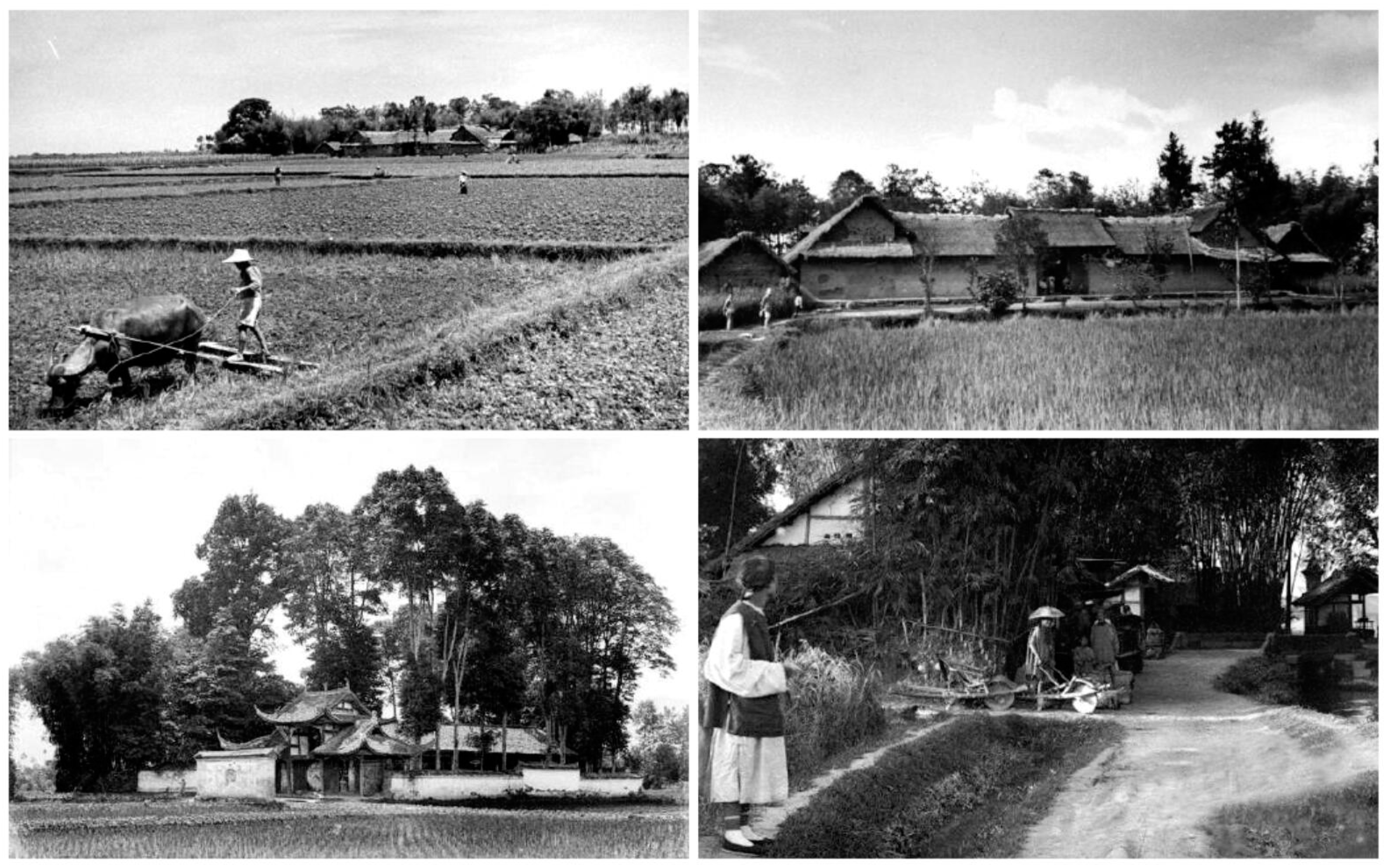
Figure 2.
Linpan landscape during the late Qing Dynasty and the Republic of China. Source: http://www.phoer.net.
Figure 2.
Linpan landscape during the late Qing Dynasty and the Republic of China. Source: http://www.phoer.net.

Figure 3.
The hierarchy structural and elements of Linpan settlements.

Figure 4.
The spatial layout of Linpan settlements.

Figure 5.
A classification sample of changes in a Linpan community.

Figure 6.
Schematic diagram of Type I changes. (a) Spatial replacement; (b) Functional replacement; (c) Old-for-new replacement; (d) New rural communities; (e) Off-site construction.
Figure 6.
Schematic diagram of Type I changes. (a) Spatial replacement; (b) Functional replacement; (c) Old-for-new replacement; (d) New rural communities; (e) Off-site construction.

Figure 7.
Schematic diagram of Type II changes. (a) Unconstrained expansion; (b) Joint expansion; (c) Constrained expansion; (d) Non-scale planting; (e) Large-scale planting.
Figure 7.
Schematic diagram of Type II changes. (a) Unconstrained expansion; (b) Joint expansion; (c) Constrained expansion; (d) Non-scale planting; (e) Large-scale planting.

Figure 8.
Schematic diagram of Type III changes. (a) Enhancement and new construction of roads; (b) Enhancement and new construction of roads; (c) Construction of public facilities and business organizations.
Figure 8.
Schematic diagram of Type III changes. (a) Enhancement and new construction of roads; (b) Enhancement and new construction of roads; (c) Construction of public facilities and business organizations.

Figure 9.
Schematic diagram of changes.


Table 1.
Statistical table of buffer zones and actual farmland area in each village.
| Village Name | Buffer Area (ha) | Actual Cultivated Area (ha) | Village Domain Area (ha) | |||||||||
|---|---|---|---|---|---|---|---|---|---|---|---|---|
| 10 m | 20 m | 30 m | 40 m | 50 m | 60 m | 70 m | 80 m | 90 m | 100 m | |||
| Dahe Village | 41.98 | 90.87 | 146.99 | 209.98 | 280.17 | 357.42 | 441.81 | 533.26 | 631.69 | 737.19 | 313.55 | 445.63 |
| Daojiang Village | 16.31 | 35.13 | 56.62 | 80.94 | 107.97 | 137.86 | 170.67 | 206.30 | 244.90 | 286.38 | 129.75 | 185.26 |
| Jinji Village | 18.41 | 39.93 | 64.51 | 92.39 | 123.29 | 157.02 | 193.68 | 233.26 | 275.87 | 321.49 | 163.61 | 219.78 |
| Longquan Village | 18.69 | 40.30 | 64.87 | 92.40 | 122.66 | 155.62 | 191.13 | 229.28 | 270.10 | 313.49 | 151.90 | 211.81 |
| Puxing Village | 33.19 | 71.05 | 113.37 | 160.07 | 211.22 | 266.88 | 327.06 | 391.72 | 460.55 | 533.79 | 284.74 | 392.81 |
| Quanshui Village | 37.53 | 81.03 | 130.63 | 186.46 | 248.45 | 316.73 | 391.25 | 471.64 | 558.23 | 651.23 | 341.31 | 484.35 |
| Sanba Village | 40.07 | 85.84 | 137.27 | 194.51 | 257.50 | 326.38 | 401.15 | 481.78 | 568.15 | 660.09 | 333.07 | 459.39 |
| Wulong Village | 31.04 | 67.60 | 109.61 | 156.90 | 209.59 | 267.72 | 331.23 | 400.17 | 474.26 | 553.39 | 301.53 | 391.49 |
| Yangqiao Village | 13.13 | 28.64 | 46.57 | 66.77 | 89.28 | 114.05 | 141.07 | 170.33 | 202.00 | 235.99 | 87.68 | 159.74 |
| Yingxiang Village | 35.14 | 76.11 | 122.93 | 175.80 | 234.74 | 299.62 | 370.48 | 447.30 | 529.95 | 618.80 | 268.31 | 386.01 |
Table 2.
Statistical table of the farming pressure coefficient of each village.
| Village Name | Tillage Pressure Coefficient (0 ≤ I) | |||||||||
|---|---|---|---|---|---|---|---|---|---|---|
| 10 m | 20 m | 30 m | 40 m | 50 m | 60 m | 70 m | 80 m | 90 m | 100 m | |
| Dahe Village | 0.13 | 0.29 | 0.47 | 0.67 | 0.89 | 1.14 | 1.41 | 1.70 | 2.01 | 2.35 |
| Daojiang Village | 0.13 | 0.27 | 0.44 | 0.62 | 0.83 | 1.06 | 1.32 | 1.59 | 1.89 | 2.21 |
| Jinji Village | 0.11 | 0.24 | 0.39 | 0.56 | 0.75 | 0.96 | 1.18 | 1.43 | 1.69 | 1.96 |
| Longquan Village | 0.12 | 0.27 | 0.43 | 0.61 | 0.81 | 1.02 | 1.26 | 1.51 | 1.78 | 2.06 |
| Puxing Village | 0.12 | 0.25 | 0.40 | 0.56 | 0.74 | 0.94 | 1.15 | 1.38 | 1.62 | 1.87 |
| Quanshui Village | 0.11 | 0.24 | 0.38 | 0.55 | 0.73 | 0.93 | 1.15 | 1.38 | 1.64 | 1.91 |
| Sanba Village | 0.12 | 0.26 | 0.41 | 0.58 | 0.77 | 0.98 | 1.20 | 1.45 | 1.71 | 1.98 |
| Wulong Village | 0.10 | 0.22 | 0.36 | 0.52 | 0.70 | 0.89 | 1.10 | 1.33 | 1.57 | 1.84 |
| Yangqiao Village | 0.15 | 0.33 | 0.53 | 0.76 | 1.02 | 1.30 | 1.61 | 1.94 | 2.30 | 2.69 |
| Yingxiang Village | 0.13 | 0.28 | 0.46 | 0.66 | 0.87 | 1.12 | 1.38 | 1.67 | 1.98 | 2.31 |
Note: I = 1 indicates the optimal spatial distribution state; I > 1 refers to a surplus labor force and high tillage pressure; I < 1 denotes excess arable lands, a labor force deficiency, and wasted resources
Table 3.
Classification specifications.
| Type | Changes in Spatial Hierarchy | Needs Level | |||
|---|---|---|---|---|---|
| I | Internal changes | IA | on-site update | a. spatial replacement | Survival |
| b. functional replacement | Survival | ||||
| c. old-for-new house replacement | Survival | ||||
| IB | off-site migration | a. concentration in new villages | Development | ||
| b. off-site construction | Survival | ||||
| II | Changes in shape | IIA | expansion of native forest | a. unconstrained expansion | Survival |
| b. joint expansion | Survival | ||||
| c. constrained expansion | Survival | ||||
| IIB | planting of economic forest | a. non-scale planting | Development | ||
| b. large-scale planting | Development | ||||
| III | External landscape changes | IIIA | municipal infrastructure construction | a. enhancement and new construction of roads | Development |
| IIIB | social infrastructure construction | a. construction of public facilities and business organizations | Quality | ||
© 2019 by the authors. Licensee MDPI, Basel, Switzerland. This article is an open access article distributed under the terms and conditions of the Creative Commons Attribution (CC BY) license (http://creativecommons.org/licenses/by/4.0/).
Share and Cite
MDPI and ACS Style
Li, Q.; Wumaier, K.; Ishikawa, M. The Spatial Analysis and Sustainability of Rural Cultural Landscapes: Linpan Settlements in China’s Chengdu Plain. Sustainability 2019, 11, 4431. https://0-doi-org.brum.beds.ac.uk/10.3390/su11164431
AMA Style
Li Q, Wumaier K, Ishikawa M. The Spatial Analysis and Sustainability of Rural Cultural Landscapes: Linpan Settlements in China’s Chengdu Plain. Sustainability. 2019; 11(16):4431. https://0-doi-org.brum.beds.ac.uk/10.3390/su11164431
Chicago/Turabian StyleLi, Qiushan, Kabilijiang Wumaier, and Mikiko Ishikawa. 2019. "The Spatial Analysis and Sustainability of Rural Cultural Landscapes: Linpan Settlements in China’s Chengdu Plain" Sustainability 11, no. 16: 4431. https://0-doi-org.brum.beds.ac.uk/10.3390/su11164431
Note that from the first issue of 2016, this journal uses article numbers instead of page numbers. See further details here.