The Integrated Approach to Landscape Management —Experience from Slovakia


1
Institute of Landscape Ecology of Slovak Academy of Sciences, 814 99 Bratislava, Slovakia
2
Faculty of Natural Sciences, Constantine the Philosopher University in Nitra, 949 01 Nitra, Slovakia
*
Author to whom correspondence should be addressed.
Sustainability 2019, 11(17), 4554; https://0-doi-org.brum.beds.ac.uk/10.3390/su11174554
Submission received: 1 July 2019
/
Revised: 29 July 2019
/
Accepted: 6 August 2019
/
Published: 22 August 2019
(This article belongs to the Special Issue Sustainable Landscape Management and Planning)
Abstract
:The integrated approach to landscape management is generally accepted, but its application is not on the desired practical level. Sectoral approaches to decision-making and planning processes still dominate. The presented paper concerns selected aspects of integrated landscape management in Slovakia. This paper reflects the present state of the long-term effort and experiences of the authors in the integration of ecological knowledge in landscape management tools. The basic methodological procedure needed to achieve this goal consists of analysis, mutual comparison, and confrontation of the existing principles and tools used in applied landscape ecology, as well as in legislation and planning practice. The landscape ecological base for the implementation of scientific achievements in landscape management consists of two methods: landscape ecological planning and ecological network planning. These two methods were implemented into the legislation and practice of nature conservation, physical/territorial planning, watershed management, land arrangement projecting, forestry planning, and flood prevention management. Such systematic landscape ecological regulations in planning practice can be considered the basis for sustainable development.
1. Introduction
In Slovakia, considerable effort has been devoted to the implementation of integrated landscape management (ILM) and its resources since the definition of ILM in AGENDA 21 at the Rio Summit ‘92. This effort considered all aspects of ILM, including defining the issue in environmental policies, the appointment of management tools for ILM (particularly spatial planning tools), the “ecologization” of these planning tools, the application of landscape ecological studies aimed at the optimal organization and utilization of the landscape, development of methods of landscape ecological planning and methods of projecting the territorial system of ecological stability, and implementation of these methods in the legislation of the Slovak Republic.
This paper explains the problems of ILM according to the experiences of the authors over the previous three decades.
This whole process is extensive and complex. This process requires an interdisciplinary approach, integrating knowledge of natural, social, and technical sciences. Particular attention is necessary to determine the best compromise between policy, legislation, scientific definitions, and spatial planning practice.
Analysis of the complex problem circle of ILM must consider all elements of the approach. In spite of its solid scientific basis, proper legal support, and well-developed planning tools, the realization of ILM is still not on the desired level.
The main aspects of this process are as follows:
● Changes in the Landscape
Integrated landscape and resource management is an imperative concern of the current age. The need for an integrated approach is strengthened by global changes, particularly the environmental changes of the last decades. Landscape processes are of crucial importance for all these changes.
The socio-economic development of each society, related to strengthening production and residential, administrative, and cultural-societal functions, results in ever-increasing pressures on ecosystems and their individual components. Human activities change the overall landscape image. Landscape is a dynamic system that is constantly changing over time. The present landscape structure, consisting of land use and land cover, is the result of gradual changes in the original natural landscape under the influence of man [1]. The cultural landscape is a representative picture of the state and development of society [2].
● Different Characteristics of Man’s Impact on Landscape—Source of Conflicts
The effects of human activities on the landscape have different forms. They are manifested by [3]: (a) localization of man-made elements in the natural landscape—construction of buildings, power lines, etc.; (b) exploitation of large areas of the natural landscape—agriculture, forestry, etc.; (c) establishment of different functional zones in order to protect elements of the natural landscape (nature conservation areas, protected water resources, etc.) and elements of socio-economic structure (protected zones of human settlements, security zones of industrial areas and transport lines, etc.); and (d) stress factors causing landscape deterioration—heterogeneous substance production, soil degradation processes, etc.
These activities are not always conveniently located in the landscape and they do not always respect the landscape’s resources and potential. The result of inappropriate implementation of socio-economic activities is the emergence of environmental problems—the degradation of natural resources and deterioration of the environment [4,5,6,7,8].
Man’s interventions often consciously or unconsciously increase the intensity of natural processes in the landscape.
● Conflict of Interests of the Activities of Different Sectors
The negative effects of the implementation of human activities in the landscape are reflected in two aspects: (a) as the loss of natural ecosystems and increasing anthropization of the territory, as well as the depletion and decrease of natural resources. An example of inappropriate management in Slovakia is the construction of industrial areas on the most fertile soils—Peugeot, Kia, Samsung, etc.; and (b) as threatening and disrupting the quality of natural resources as a result of the influence of foreign substances, which are concomitant phenomena of human activities. The result is air pollution, contamination of the soil, contamination of river sediments, pollution of water resources, noise pollution, light effects, electromagnetic smog, increased radioactivity, etc. Consequently, the contamination is reflected by deteriorated environmental quality and a threat to human health. The construction of objects also changes the structure of the landscape and its overall image. In many cases, it also contributes to disrupting the visual quality of the environment.
The emergence of these problems is, in many respects, the consequence of the application of a sectoral approach to landscape management; in other words, the use of the territory mirrors the positions and strong influence of individual sectors [9,10]. An example of such a large-scale conflict is the case of the most fertile part of Slovakia, the region of Žitný ostrov (Rye Island): there, the highest quality soils are under intensive agricultural use, regardless of the fact that the same area is the biggest reservoir of drinking water in Central Europe, legally declared as Protected Water Area Žitný Ostrov, and, at the same time, also a legally declared nature conservation area Dunajské luhy Protected Landscape Area. The basis for solving these problems is the application of integrated management of the landscape [9,10,11,12].
● The Scientific Approach to the ILM
The main scientific question of ILM was to find out how landscape ecological knowledge can be functionally applied to the real management processes, in particular, to the decision-making and planning practice, which have jural and technical science bases. In other words, this process can be characterized as the implementation of applied landscape ecological methods to existing legal and planning tools. This interdisciplinary process was demanding and complicated. It requested the integration of deep landscape ecological knowledge and the ability to develop applied methods for the practical evaluation of the landscape system, and on the other side, theoretical and practical knowledge on the legal background of the spatial planning, as well as on the practical procedures of spatial planning and projecting.
The most concrete early result of this effort was the development and implementation of the method of landscape ecological planning (further on as LANDEP) [3,13,14,15], and the method of the projecting the territorial system of ecological stability (further on as TSES) [16,17,18,19] to Act No. 50/1976 about territorial planning and construction order, as amended in Act No. 237/2000. It was and still is a legal tool of integrative character in Slovakia (more details below).
It is worth mentioning that the term “territorial planning” (územné plánovanie in Slovak) covers a complex procedure considering the spatial organisation and functional use of the entire territory on the defined level (national, regional. communal, local) and considers the need for all relevant sectors. Therefore, the act on territorial planning is considered the most integrative legal tool in Slovakia. Territorial planning can be compared to terms such as spatial planning, physical planning, and land-use planning.
According to the aforementioned principles, the partial objectives of the presented article were to answer three basic question circles of the process of ILM:
- how the integrated management is applied in the legislation and to the development documents in Slovakia;
- how the representatives of municipalities perceive the integrated approach to landscape management;
- how the scientific knowledge on the principles of ILM are transformed into the real practice of spatial planning documentation.
2. Materials and Methods
As is obvious from the introduction, the method of development of ILM is a complex process of interdisciplinary character. Within the scope of this paper, we only present the framework of procedures which play a role in the process of the implementation of ILM in Slovakia.
The basic methodological procedure to answer the questions stated in the previous section consisted of detailed analysis, mutual comparison, and confrontation of the existing principles defined by applied landscape ecology with the legally supported tools for landscape management. The following sections explain three different methodical steps of the ILM as
1) The analysis of institutional tools—legal tools and strategic development documents from the point of view of the application of ILM. This is the legal base for ILM.
2) The participatory approach to the ILM—the attitude of representatives of regional and local administration to the implementation of landscape ecological and environmental principles in development documents of municipalities and regions. This is the condition for the real implementation of ILM.
3) The development of a landscape ecological plan was implemented in the model area of the Klátovské rameno National Nature Reserve. This is an example of the expert approach to the processing of landscape ecological documentation for further use in development documents.
2.1. The Analysis of Institutional Tools for ILM—Legal Tools and Strategic Development Documents
During the development of the process of ILM, we analyzed relevant international documents as the background. These were the AGENDA 21, as a very basis for the ILM, in particular Chapter 10, and the integrative elements also relate to the IPPC Directive, NATURA 2000, the Water Framework Directive, and the INSPIRE Directive. Other important documents included the Europäische Raumordnungs Charta, the Alpine Convention, the Carpathian Convention, the Danube River Protection Convention, the European Landscape Convention, and the EU Strategy for the Danube Region. Of course, the AGENDA 2030 and its sustainable development goals (SDGs) should also have been analyzed, even though, in this document, the concept of integration was conceived in a specific way.
However, in reality, the ILM can be realized only on a national level; therefore, the main attention was paid to legal and other strategic documents in Slovakia. Several sectoral acts aimed at protecting individual components of the environment—water, soil, air, geological sources—and legislative tools for spatial planning and land consolidation act, which could have integration potential, were investigated.
Accordingly, during the process of implementation of a landscape–ecological base to legal tools in the years 1990–2010, many legal and other documents were amended by landscape ecological principles. This process also was marked as the ecologization of legal tools. The process concerned the following documents:
Acts:
- a)
- Act No. 50/1976 Zb. on territorial planning and building order (Building Act), according to the wording of the Act of National Council of the SR (further NC SR) No. 237/2000 Z.z., as well as the wording of provisions issued during this period as Acts of NC SR No. 103/1990, No. 262/1992.
- b)
- Act of the Slovak National Council No. 330/1991 Zb. on land consolidation, land ownership, land offices, land pool, and land associations (in the wording of later issued provisions, for instance, in wording of the Act of the SNC No. 323/1992 Zb., Acts of the NC SR No. 187/1993 Z.z., and No. 549/2004 Z.z.
- c)
- Act of the NC SR No. 543/2002 Z.z. about nature and landscape protection in the wording of later issued provisions.
- d)
- Act of the NC SR No. 245/2003 Z.z. about integrated prevention and control of the environmental pollution and about the amendment of certain laws in the wording of later issued provisions.
- e)
- Act No. 364/2004 Z.z. about waters (Water Law) and about the amendment of Act of SNC No. č 372/1990 about infringements in the wording of later issued provisions.
- f)
- Act of the NC SR No. 24/2006 Z.z. about environmental impact assessment in the wording of later issued provisions.
- g)
- Act of the NC SR No. 3/2010 Z.z. about a national infrastructure for spatial information.
- h)
- Act of the NC SR No. 7/2010 Z.z. about flood defence.
- i)
- Act of the NC SR No. 326/2005 Z.z. on forests as amended.
- j)
- Act of the NC SR No. 39/2013 Z.z. about integrated prevention and control of environmental pollution and about the amendment of certain laws.
Other strategic documents:
- a)
- National Strategy for Biodiversity Protection;
- b)
- Concept of Territorial Development on the level of Slovakia, and on regional and local levels;
- c)
- Territorial planning documentation;
- d)
- Landscape ecological documentation—landscape plans and projects of territorial system of ecological stability on regional and local levels;
- e)
- Economic and social development strategies.
The assessment of the integration potential was based on two groups of criteria [13]: (1) the complexity of tools—how can the tools allow the consideration of all dimensions of the landscape (economic, environmental, social dimension); and the (2) intersectoral dimension of tools—the principle of supra-sectorality. This was the evaluation of whether the sectoral approach is applied only from the aspect of one sector or from the perspective of a cross-sectoral approach. The proposals of ecologization took into account the requirements of several sectors aimed at the most optimal environmental use).
2.2. The Participatory Approach to ILM—the Attitude of Representatives of Regional and Local Administrations to ILM
A positive attitude of the representatives of regional and local administrations toward the implementation of landscape ecological and environmental principles in development documents of municipalities and regions is an inevitable condition for the real implementation of ILM. As an example, the sociological survey carried out in the urban functional region of Trnava focused on finding the opinion of 28 representatives of the local government and three representatives of the regional government. The sociological survey was realized in the form of structured interviews. The interviews observed the following topics: (Q1) what environmental documentation do you know and what environmental documentation is implemented in your municipality/region? (Q2) Do you find these documentations useful? Do you use these documents in the management of the municipality/region? (Q3) Have you applied the outputs from these documentations to land-use planning documentation? What problems do you have with the application of land–ecological regulations in the area management? (Q4) What do you consider to be the biggest problems with the processing and utilization of environmental documentation?
The interviews were recorded in writing and subsequently evaluated.
2.3. The Development of a Landscape Ecological Plan in the Model Area of the Klátovské rameno National Nature Reserve
We present this case study as an example of the expert approach to processing landscape ecological documentation for further use in development documents. The study was focused on the preparation of landscape ecological materials for land-use planning documentation, in particular for the proposed functional use and spatial organization of the territory.
A brief description of the extensive process is as follows:
The study area represented an extremely geographically and biologically valuable complex. Despite the intensive cultivation and urbanization of the land (since the area belongs to the most productive agricultural area in Slovakia), many high-quality natural areas have been preserved in this region as characteristic parts of the landscape, such as forest vegetation areas with native tree species, natural water courses with original bank vegetation, parts of alluvial floodplains with original biocoenosis, marsh habitats, and alluvial forest communities [20].
Klátovské rameno was included by Act No. 287/1994 on Nature and Landscape Protection as National Nature Reserves with the highest degree of protection on an area of 306.44 ha. At the same time, the territory is a supra-regional biocentre.
Klátovské rameno National Nature Reserve is part of the Dunajské luhy Protected Landscape Area (further on PLA). PLA was declared on 1 May 1998 with a total area of 12,284 ha. The Dunajské luhy PLA forms a substantial part of the Ramsar locality Dunajské luhy. The Dunajské luhy is also an important bird area of Europe and is included in the IBA (International Bird Areas) as an internationally important area for the protection of birds at a global, regional, and subregional level. A large extent of the area is dedicated to drinking water protection and is declared as the Žitný ostrov Protected Water Zone. This area is the base for the water supply for more than 400,000 inhabitants of Western Slovakia.
The final steps of the landscape ecological plan on model area were:
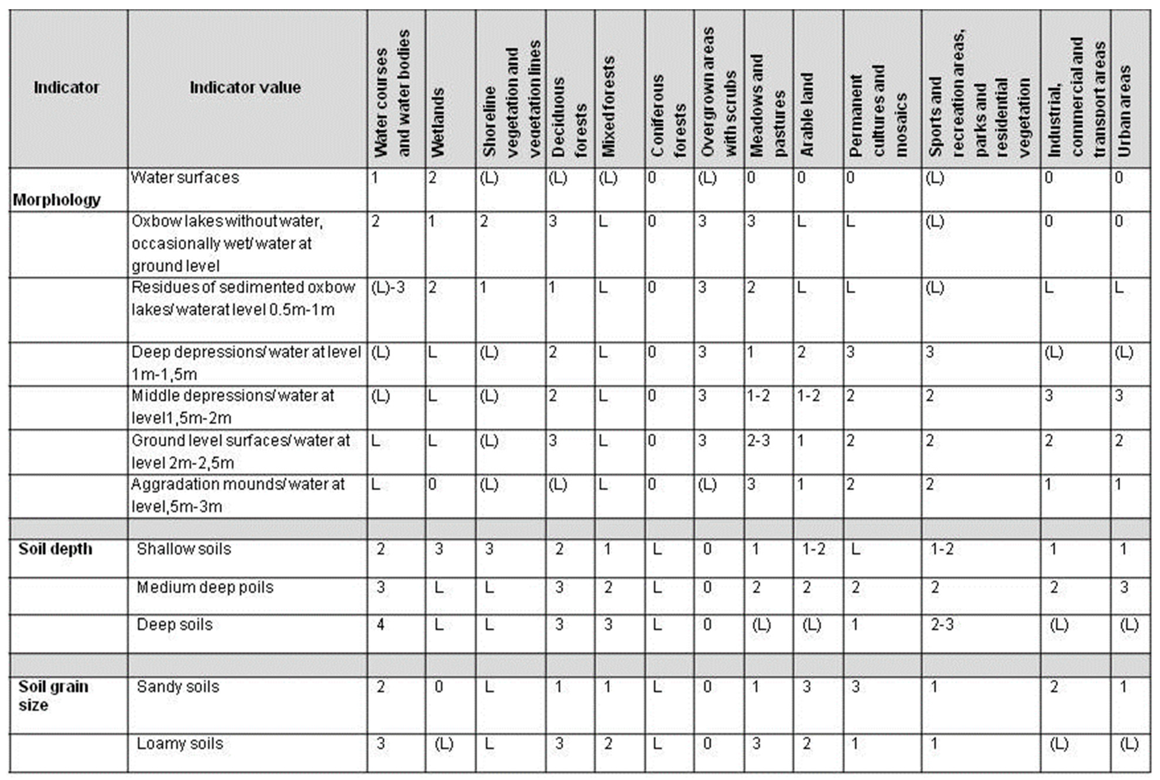
1) Landscape ecological evaluation—the process of determining the suitability of landscape properties for the localization of selected social activities [14]. Evaluation is at the core of the whole decision-making process in which the demands of individual activities are confronted with landscape ecological conditions and the actual values of the landscape through limits.
There were two basic complexes of inputs to this process [21]:
- a)
- Properties of the landscape—abiotic, biotic, socio-economic—which are represented by synthetic units—landscape ecological complexes (LECs). The LECs are the result of extensive landscape ecological analyses and syntheses. Types of LECs are defined by a combination of relevant natural and socio-economic indicators and have real spatial expression on maps. The spatial synthesis of LECs was realized by GIS applications. An example of landscape ecological complexes as basic operating units for decision-making processes is shown in Figure 1.
- b)
- Proposed activities and land use reflect the requirements of communities.
The basis of the decision-making process is the determination of the suitability of the properties of individual LECs for the implementation of socio-economic activities. The properties of LECs play the role of restricting and limiting activities. This limit is considered as the threshold—the marginal value of the indicator (or set of indicators) of the property of an LEC for a proposed activity that ensures conflict-free land use by man. It expresses a set of conditions which create suitable conditions for individual human activities and human life on Earth without significant disruption with respect to threats to components, bonds, and processes in the landscape. Specifying limits results from the purpose of the landscape (from the abiotic, biotic, and socio-economic characteristics of the landscape), as well as from legislative regulations and standards [21,22,23].
The limits are conditioned by the characteristics of the landscape elements. They are based on the environmental assessment of these elements. Based on the nature of their action, environmental limits can be divided into the following basic groups: abiotic limits, limits resulting from the effects of natural stress factors—natural hazards and risks—limits of current landscape structure, limits resulting from nature and landscape protection, and limits resulting from anthropogenic stress factors.
Within the elaboration of the landscape ecological plan, four levels of suitability/unsuitability for the realization of socio-economic activities on a given area are usually set [24], which are marked as:
0: exclusionary values, i.e., not suitable from the environmental point of view and impossible even from a technical point of view.
L: limit values, i.e., not suitable from the landscape ecological point of view—the realization of socio-economic activity is excluded on the given LEC.
(L): conditionally suitable and limited—the given activity can be located in a given LEC, but not proposed from the landscape ecological aspect because the given activity is also possible in other LECs (e.g., forests and landscape greenery are possible in any LEC), and the given LEC is needed for the realization of more intensive use.
1, 2, 3: the implementation of socio-economic activity is appropriate in the area. The figures indicate the level of suitability (1 = best suitability).
The evaluation is processed as the “decision-making table“. An example of this is provided in Figure 2.
Limits and restrictions in the landscape do not act in isolation, but synergistically. The localization of a given human activity can be limited or restricted by one, two, or more factors. The determination of limiting and restricting factors for a given activity is based on an assessment of the functional relationship between all properties of the LEC, i.e., the abiotic, biotic, and socio-economic properties.
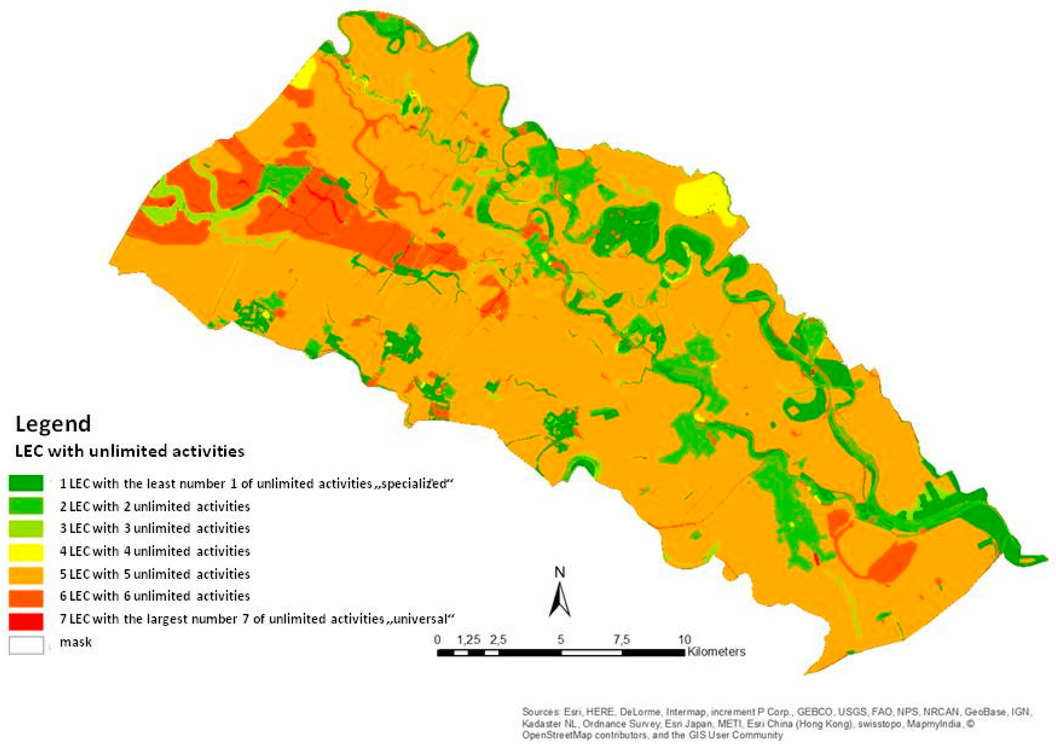
The results of the evaluation can be presented in very different modes. The most usual way is to present which activities are suitable and which ones are limited. Another pragmatic mode (many times requested by municipalities) is to display the overall level of limitations according to the number of activities which are limited/unlimited. An example of the expression of this result in the area of Klátovské rameno National Nature Reserve is presented in Figure 3.
2) Landscape ecological proposition—a proposal of the landscape’s optimal ecological use consisting of: (a) setting an alternative ecological selection: we define for each LEC those activities that are limited or restricted and those that can be localized. This proposal is based on the synthesis of unlimited activities from a landscape ecological point of view, but also considers management regime and specified technologies; (b) determining ecologically optimal land use—setting the most appropriate activity for each area. The resulting proposal of landscape ecologically optimal land use is confronted with an alternative ecological selection with the current landscape structure (current land use, CLS).
The following principles are used in this final selection process: (1) if the CLS element is identic with an activity which is according to our evaluation process within unlimited activities and reaches value 1 in the limit table, we leave the current use unchanged; (2) if the CLS element is within the unlimited activities and has a value of 0 in the limit table, it is necessary to reduce its intensity or it is necessary to define measures on the basis of which the activity can be realized; (3) if the CLS element in the alternative landscape design is limited, i.e., in the limit table, it has a value of L, we propose a change of the CLS and, at the same time, we propose an socio-economic activity which reached the best value, as the most suitable alternative.
At the same time, we usually respect some obvious physical and social limits of given CLS, e.g., built-up areas, transport and other technical objects, greenery, forests, waters, and permanent cultures that we do not propose to change, but we propose measures to mitigate their negative impact.
According to the typology of specified landscape ecological principles [25], landscape ecological measures are described as: (a) measures to improve ecological stability and biodiversity; (b) measures to protect natural and cultural/historical resources; and (c) measures to improve the quality and aesthetics of the environment.
All the described aspects of the landscape ecological plans are presented on maps.
3. Results
3.1. Chosen Aspects of the Institutional Tools for ILM
● Institutional tools for ILM: international level
The base for integrated landscape management was stated in Agenda 21 [26]. Chapter 10 of AGENDA 21, entitled “Integrated approach to the management of land resources”, defined the basic theses of integrated landscape management as follows:
- All activities may take place in the same landscape, but they are in conflict; therefore, they need an integrated approach;
- If an activity harms one component of the landscape, the other components and the overall functioning, ecological balance, and stability of the landscape are endangered. On the other hand, an optimal measure applied to protect the landscape as a whole may protect all other individual components.
AGENDA 21 was designated as the basic tool for the physical planning (Figure 4), which should be the obligatory frame and basis for all other planning processes.
These principles are still valid and they have been supported by all successive conferences of Rio Summit ´92 and other international conferences.
The European Union has made a strong effort towards the application of integrative tools for the optimal utilization of natural resources. In particular, the IPPC Directive, the NATURA 2000, and the Water Framework Directive should be mentioned in this respect. All the above-mentioned organizations were intended to be supported by the INSPIRE Directive, which enforces the integrated spatial information system as the inevitable basement of an integrated approach. Integrative character also includes the Europäische Raumordnungs Charta and regional conventions, such as the Alpine Convention, the Carpathian Convention, and the Danube River Protection Convention [27,28,29,30].
Specific attention should be paid to the European Landscape Convention of the EEC. The European Landscape Convention [31] bears a specific importance for bolstering the practical implementation of integrated landscape management. The Convention promotes the importance of landscape, its conservation, management, planning, and care across the complete decision-making process and international cooperation. By adhering to and signing the Convention, the parties commit themselves to adopt multiple particular attitudes and measures, including a clear land use policy, a systemic approach to landscape, the adoption of specific measures for the protection of different landscape types, naming the landscape identity, the introduction of public participation in the decision-making process concerning landscape, the integration of landscape into regional and settlement policies and planning, cooperation in implementation and mutual help, cooperation in international policies and programs, the delimitation and definition of proper landscape types in a party’s territory, analysis of their characteristics and the driving forces and pressure that form them and tracking the changes, and the evaluation of the delimited and defined landscape types regarding the particular assets attributed to them by the concerned parties and by the population.
According to these documents, the concept of ILM is generally recognized as the best framework for the management of natural resources, which accomplishes several environmental objectives, such as the reduction of soil degradation, the conservation of biodiversity, the preservation of water in ecosystems, flood prevention, the improvement of water quality, and the reduction of the factors accelerating climate change. It is also considered an innovative way to mitigate the size, duration, and rate of the negative effects of humans on the landscape [9], but also as a framework for the achievement of economic and social targets and even as a tool for minimising the negative impacts on communities [11,32].
However, integrated management has become a fashionable term. Specialists often use it to refer to very different procedures and activities. In agreement with the still valid theses of Agenda 21, the main principles of integrated landscape management for scientific, as well as for practical reasons, are defined as follows: (a) management is a ruling device which comprises the chain of planning–organising–controlling, which harmonizes the demands of different sectors with respect to sustainable development; (b) accordingly, integrated management is not a concrete physical activity that is executed, e.g., in watersheds, nature conservation areas, forestry, agriculture, etc. These, of course, may finally lead to the expected effects, but they are just physical, sectorial works, whereas management is policy, which forces the subjects to provide such works [33].
The present trends of sustainable development are also determined by other integrative principles such as (a) partnership and supra-sectorial approach as a principle of cooperation between individual sectors and industries. This is the economic precondition of ILM announced at the Rio+10 World Summit of Sustainable Development in Johannesburg in 2002, as well as in the UN AGENDA 2030 from 2015. One of the most stated principles in the SDGs is that everything should be inclusive. (b) Supra-regionality is the spatial-political precondition of ILM, and (c) landscape ecological complexity, as the principle of scientific/professional integration, the principle of the integrated approach towards natural resources. This is the natural-scientific precondition of ILM.
● Institutional Tools for Integrated Landscape Management in Slovakia
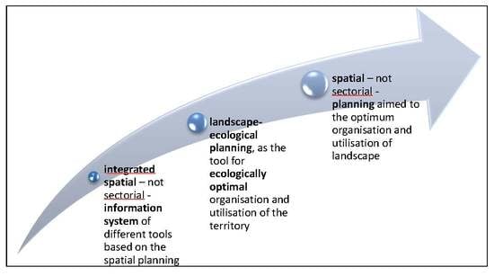
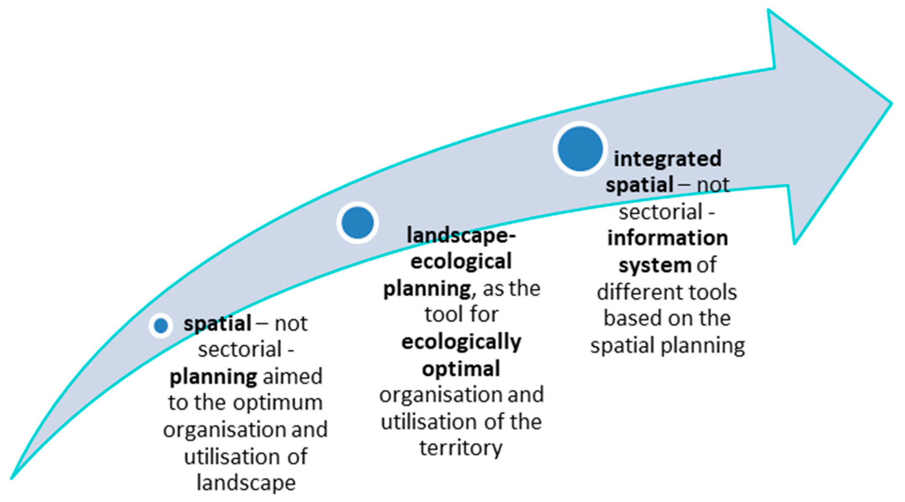
The long-term experiences with the implementation of the LANDEP and TSES methods allow us to state that key necessities for ILM are to define the existing tools or develop new tools such as (a) spatial—not sectorial—planning defined by law, aimed at the optimal organization and utilization of landscape, (b) the procedure of landscape ecological planning as the scientific background basis for legally adjusted spatial planning and as the tool for ecologically optimal organization and utilization of the territory, (c) an integrated spatial—not sectorial—information system.
Evidently, ILM is not—and probably never will be—one single tool, but a logically arranged, harmonized system of different tools based on the abovementioned spatial planning. This system should be prescribed by law.
This was the case in Slovakia, where integrated landscape management was defined in Act No. 7/2010 on Flood Prevention. The § 9, section 1 reads as follows: “...both the plan of the flood risk management and the watershed management plan shall be coordinated with all the land arrangement projects, territorial plans and forest management plans. They all together will constitute the tool of integrated landscape management on the whole territory of the watershed.”
The wording of this provision has slightly changed since, but its essence is still valid.
According to the content, the legal position, as well as the position in the integrating process, the existing legal tools can be classified into four groups [19,33,34] as follows:
a) The informational base for integrated landscape management.
This should serve as the unified information base for all activities in the territory. The legal bases of this tool are:
- Act No. 3/2010 on the national infrastructure for spatial information
- the definition of the landscape ecological base for integrated management in Act No. 7/2010 on flood prevention
b) The landscape ecological and physical (spatial, territorial) frame for integrated landscape management.
These tools ensure the transfer of the properly processed and interpreted landscape ecological documentation produced by the TSES and the LANDEP, which are legally confirmed obligatory parts of territorial planning. Their main outputs are ecological limits and regulations, ecological networks, and the proposal for the ecologically optimal organization and utilization of the landscape.
The territorial plan in Slovakia is legally defined as a base for all other spatial planning tools. Therefore, this corresponds with the provisions of AGENDA 21 which stated that the physical plan should be the “frame and base for all other sectoral plans”. The legal base of these tools is:
● Act No. 50/1976 on territorial planning and building order (Building Act) (according to amendment Act No. 237/2000).
The LANDEP and the TSES are defined in the same act as obligatory regulations. The TSES is basically defined in Act No. 543/2002 on Nature and Landscape Conservation, but also in all sector-bound planning laws. The key provisions in the above-mentioned acts are the definition of the landscape as the geosystem and the definition of the properties of the landscape elements as the regulations, which exclude, limit, or support the execution of activities in a certain area.
● Act No. 330/1991 on land consolidation, settlement of land ownership, land offices, land pool, and land associations (in the wording of provisions issued later, for instance in Act 549/2004).
An obligatory part of land consolidation is also the territorial system of ecological stability. Elements of the territorial system of ecological stability and significant landscape features are considered as common facilities within land consolidation. Also included in the TSES [18] are “ecostabilization measures”, especially on agricultural land, which must be respected in land consolidation [35,36].
c) Tools of sectorial planning and management.
These are the executive tools for the concrete planning and projecting of the landscape. In an ideal case, these tools would achieve the ecological and integrating principles in the concrete territory. The following acts and legal provisions belong to this group:
- The Nature and Landscape Conservation, executed according to Act No. 543/2002
- Land arrangement and consolidation projecting, executed according to Act No. 330/1991
- Forestry planning, executed according to Act No. 326/2005
- Water planning and watershed management, executed according to Act No. 364/2004
- Flood-protection management, executed according to Act No. 7/2010.
d) The tools for the control, assessment, and regulation of the environmental impact.
These tools are not for direct management of the landscape, but they control and assess the impact of spatial activities of the sectors; therefore, we can consider them as important tools for the regulation of such activities. The following acts and legal provisions belong to this group:
- Integrated Prevention and Pollution Control, executed according to Act No. 39/2013,
- Environmental Impact Assessment (EIA) and Strategic Environmental Assessment, (SEA) executed according to Act No. 24/2006.
e) Other strategic development documents.
The principles of integrated management should also be taken into account by other strategic documents. Among them, the plan of social and economic development of communities, as well as the documents of local AGENDA 21 can be mentioned. Although these documents should be based on all three pillars of sustainable development (social, economic, and environmental), as these are all evaluated separately, their synthesis is lacking. The implementation of landscape ecological plans and a territorial system of ecological stability in these documents is on varying levels, depending on the individual knowledge of the providers.
A specific integrating element for all the above listed tools is the Territorial System of Ecological Stability (TSES)—the system of ecological network of the biocentres, biocorridors, interactive elements, and the ecostabilizing measures [17,18,36,37].
These documents play important roles in each of the above-mentioned documents.
3.2. The Attitude of Representatives of Regional and Local Administrations to ILM—A Participatory Approach to ILM
In this section, we present the problems of implementation of principles of integrated management in real practice on the municipal level based on the results of a goal-oriented sociological survey. The main aspects of this survey were as follows:
Despite the undeniably important role played by landscape ecological principles in spatial planning processes and sectoral documentation aimed at integrated management, the implementation of landscape ecological documentation in practice has been met with great displeasure. The main causes of the problems of their application are:
a) Misunderstanding of the importance of landscape ecological documentation within spatial planning processes by the procurer (mainly the local government).
The procurers did not sufficiently understand the importance of integrated management as a tool for optimal utilization of land potential. At the same time, the integrated approach can eliminate the existing environmental harms and will prevent new environmental problems, as well as natural hazards and threats such as floods, erosion-accumulation processes, landslides, etc. As may be seen from interviews with local government representatives, many mayors consider that environmental documentation hinders the development of their town or village.
b) Complexity of the methodological procedure for the processing of landscape ecological documentations.
The recommended methodology of the landscape ecology plan by the Ministry of Environment of the Slovak Republic [21] and the methodology of TSES [18] are based on the methodology of landscape ecological planning (LANDEP) [14]. This is an open system of a set of consequent steps, modifiable on the basis of territory specificity, scale of processing, time horizon of the processing of the task, etc. It should be recalled that modifying individual steps requires professional experience and cannot be passed on to persons who are not familiar with the basic principles of landscape ecological planning methodology or have no experience with similar landscape ecological methods.
c) Lack of specialists for documentation processing.
The processing of documents requires experience with integrated management methods. There is a need for deep knowledge of the relationships and processes in the landscape. Unfortunately, the most common case is that the whole landscape–ecological documentation is limited to mapping the land use/land cover (often to a very simply level) and identifying the “green areas” as the TSES elements. The elaboration of quality documentation requires an interdisciplinary team of specialists; however, such teams are currently very scarce.
d) Lack of experience with the processing of landscape ecological studies.
Despite the legislative anchoring of the need to implement the principles of integrated management with appropriate landscape ecological documentation, this is rarely seen in practice.
e) Low promotion and poor explanation of the reasons of landscape ecological documentation.
The problem is the lack of awareness of the requirements for processing quality documentation. Due to the lack of "positive" examples, there is an absence of possibility for comparison. Similarly, the competent authority for landscape ecological plans (until 2003—MoE SR, currently the Ministry of Transport and Construction of the Slovak Republic, and the Ministry of Agriculture for TSES projects) paid little attention to promoting landscape ecology studies. There is also a deficiency in professional qualifications, as they are not required for the processing of the LEP, which often leads to the fact that the landscape plan is not processed by experts in the field.
f) Low effectiveness of quality control of documentation processing and of the incorporation of results into the next stages.
A significant problem of processing a quality document is the low effectiveness of its control. The status of the documents only as a “recommendation” causes them to be ignored. This is also due to the fact that contracting authorities often do not have a consistent understanding of the significance of studies and thus do not require them to be processed in a good quality.
g) Insufficient application of landscape ecological regulations to spatial and sectoral policies.
Act No. 50/1976 on territorial planning and building order (Building Act), as amended in Act No. 237/2000, defined a landscape ecological plan as an essential and obligatory part of surveys and analyses. The mentioned Act defined the ecologically optimal spatial organization and functional utilization as a comprehensive process of mutual reconciliation of spatial requirements of economic and other human activities with the landscape ecological conditions of the territory resulting from the landscape structure. The processing of landscape ecological documentation as a separate document is self-serving and meaningless. From the point of view of landscape ecological optimization, it is necessary to respect and reflect landscape ecological regulations in the binding regulations of spatial development of the territory. Otherwise, the processing of landscape ecological documentation becomes irrelevant. Unfortunately, this is often the real case, which does not meet the requirement of ILM.
h) Refusal and underestimation of landscape ecological documentation by territorial planning and land consolidation projects.
The processing of the documentation of territorial planning has a long-term tradition in Slovakia. There is a lack of willingness to change already established procedures by projectants. Therefore, the processing of landscape ecological documentation is well-liked, as this process increases the complexity of the proposals of spatial organization and the functional utilization of the territory, if compared to the classical processing of the documentation. The spatial planning projectants consider landscape ecological studies to be a "dire obligation".
3.3. Landscape Ecological Plan in the Model Area of the Klátovské rameno National Nature Reserve
This case study is an example of the expert approach to processing landscape ecological documentation for further use in different development documents.
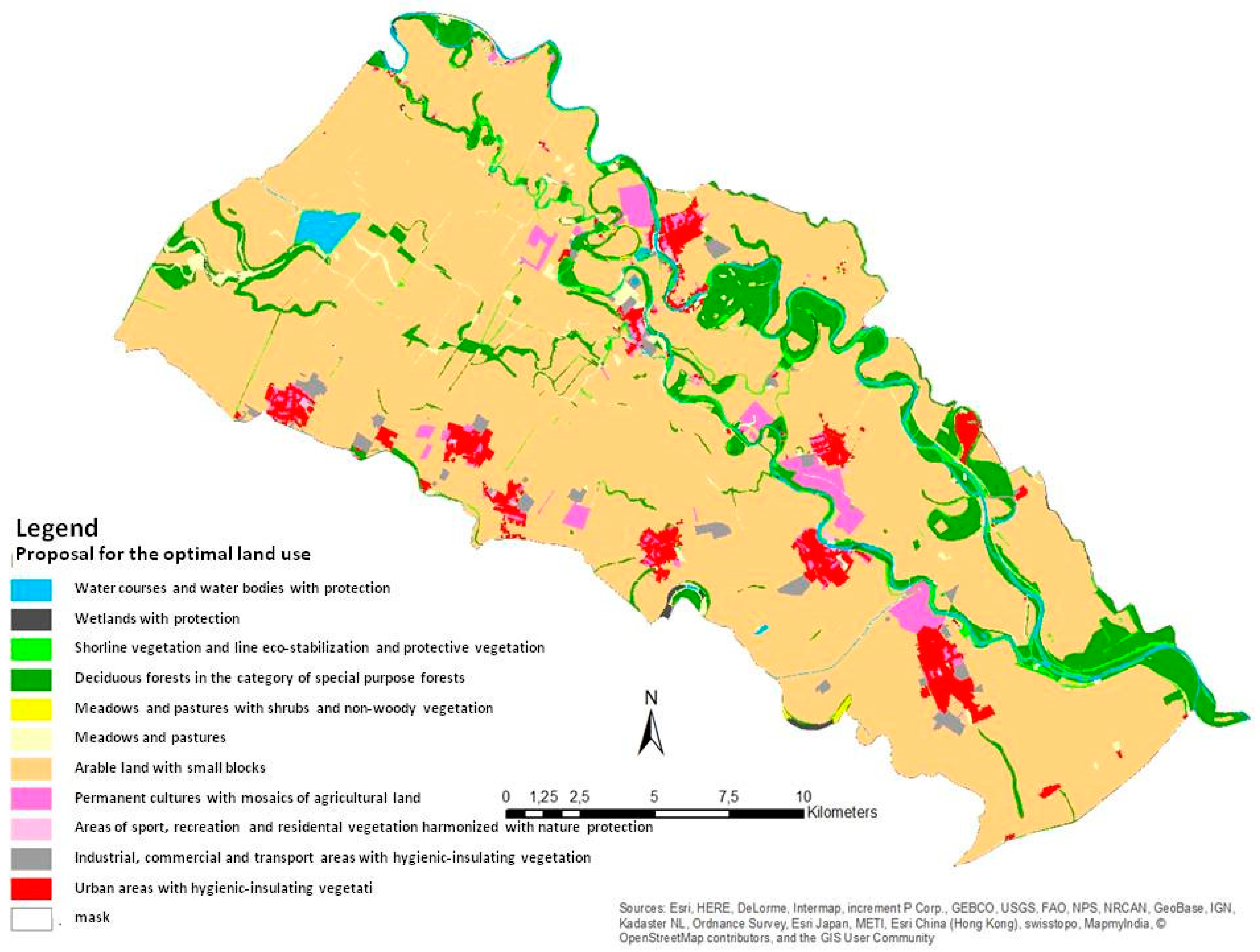
The methodologies of the TSES and LANDEP were applied to the territory of the Klátovské rameno National Nature Reserve. The result is the proposal of ecological optimum land use, also taking into account sectoral demands and current land use. Therefore, we can state that the procedure responds to the principles of ILM. The results are displayed in Figure 5.
The most significant aspects of the landscape ecological proposition were as follows:
a) Changes as compared to the current land use:
- Increasing the share of protective forests with extensive management in order to protect ecological network elements—biocentres and biocorridors.
- Increasing the share of linear and areal nonforest vegetation, which, in many cases, create the base for local biocentres and biocorridors, such as waterside vegetation, ecostabilizing vegetation, groves, and increasing the share of protective vegetation in the vicinity of industrial buildings, transport lines, as well as vegetation creating biocorridors and windbreaks.
- Increase of the proportion of the vegetation in residential areas, especially park vegetation, which will contribute to the improvement of the coefficient of ecological stability in individual municipalities of the region.
- Proposal for a new land parcelling—reduction of arable land parcel size, preference for small-scale parcels, fragmentation of the arable land.
- Proposal for a change in the management of the agricultural land fund: specific measures were proposed with regard to the protection of soil and water resources and with regard to the needs of nature protection, as well as measures for the proper exploitation of contaminated soils.
- Proposal to change or suspend intensive cultivation of the agricultural land in the immediate vicinity of the flows and river arms nearer to the waterside than 30 m, and consequently the conversion of this area to permanent grassland, which should be regularly cut. Another possibility is the afforestation of the area with native tree species or a combination of grassland and afforestation.
b) Measures to regulate land use and cultivation:
- Proposal for regulation of agrochemicals near the watersides and in other areas with intensive percolation. We proposed to completely exclude the use of inorganic and liquid organic fertilizers and we recommended biological forms of farming, e.g., green fertilization.
- Proposal for the renewal of forest management plans (FMP) due to forestry activities. The FMP should prescribe the mode of timber harvesting, other removals of woods, landscaping, and restricting the spread of invasive plant species in protected areas. We recommend ensuring indirect recovery by restoring the composition of species with predominant, even 100% representation of the gray poplar (Populus canescens). Furthermore, we recommend that the forest status of legally defined “productive” forests should be transferred to the status of “special purpose” forests.
- Removal of auxiliary plant species by regular and controlled cutting, which contributes to the preservation of native habitats.
- Maintenance of old tree vegetation (head willows) in order to preserve the suitable trophic and topical conditions for animals that are bound to them (invertebrates, cavity nesting animals, some species of mammals, fungi).
- Regular mowing of grassland is essential in order to preserve their character as a nesting site for aquatic and wetland birds.
- Management of littoral vegetation: regular mowing of shores (reeds and bulrushes) on adjacent land.
- Grazing and combined grazing with mowing in meadows to maintain the character of these habitats.
c) Measures concerning the protection of water resources:
- Measures to prevent shore abrasion by planting at least a 10 m wide strip of woody vegetation composed of indigenous species characteristic of the site.
- Proposal to eliminate the impact of stress factors on groundwater. A thorough review of the impact of industrial and agricultural operations is necessary. This includes regulation of the concentration of livestock production, improvement of the farmyards whose technical conditions do not adhere to hygiene principles, completion of silage pits and unpaved field fertilizer storages, and regulation of the use of agrochemicals.
- In addition, it is necessary to investigate the impact of landfills on groundwater, to eliminate illegal dumps, to ensure the regular collection of municipal waste, and to prevent the establishment of unorganized landfills.
- It is also necessary to prevent groundwater degradation by leakage from nonwatertight cesspits, to ensure the construction of a public sewerage system connected to the sewage tank, and to review the current state of the sewerage system in the area.
- Further proposals concern the regulation of the use of water areas with regard to the needs of nature protection and the need to protect the soil fund.
- The above-listed landscape ecological regulations resulting from the landscape plan are prepared to be incorporated into the respective sections of the land use plans.
4. Discussion
The principles of ILM were described in different publications [38,39,40,41,42,43,44,45]. All the authors underlined that ILM must be based on interdisciplinary, complex, and balanced research in three areas: environmental, social, and economic [46]. A special effort should be made in research of the interconnections and interrelations between these particular spheres.
The results of the long-term works and experiences on the topic of ILM briefly introduced in Section 3.1 confirmed several basic issues, such as
1) The importance of the acceptance of principles defined in both the international and national documents.
Basically, the synthesis of knowledge given in different policy documents on the development of ILM confirmed the necessity to respect the following principles (Figure 6):
Principle of supra-regionality: For successful implementation, it is necessary to ensure regional cooperation. Natural units must be preferred to administrative units, as ecological or stress phenomena and processes do not respect administrative boundaries; rather, they depend on natural conditions such as relief, climate, land use, etc. Implementation of the EU Water Framework Directive concerns the management of river basins on their entire territory within its natural watershed’s hydrological units. Precisely, the space and position of the watersheds are the represent the integrity of individual natural resources in a given territory.
Supra-sectorial principle: The environmental principles must be respected by all industries and sectors. Preference for economic development at the cost of environmental and social factors is inadmissible in the light of sustainability principles. Moreover, landscape ecological methods should accept the needs of the development of sectors and municipalities. The harmonization of these different needs is one of the key goals of ILM. All the problems in the landscape are interlinked; for instance, changes in land use considerably influence biodiversity and ecological stability, pollution requires investments into the mitigation of the resulting damage and the implementation of new technologies, and negative environmental impacts are often connected with social problems, including unemployment, an increase of negative socio-pathological phenomena, etc.
Principle of landscape ecological complexity: The optimum organization and use of a territory must be considered in the light of a complete set of properties of the geosystem. This optimization is based exactly on the confrontation of conditions provided by the geosystem with the requirements of society. Therefore, the geosystem approach in a certain space must be applied [10].
Principle of coordination and participation: All the possible actors and stakeholders must be invited to participate in the preparation and implementation of the management plans. Only such cooperation can ensure success. The importance of involving stakeholders in decision-making processes has been stressed by various authors [47,48,49,50,51].
The success of the ILM depends on the mode of their implementation in the international and national legal system. As shown in the previous sections, in Slovakia, all the above-mentioned principles are sufficiently declared in several Acts. The most integrative Act No. 50/1976 on territorial planning and building order, in the reading of amendment Act No. 237/2000 on territorial planning, defined the object of planning as a geosystem, as well as the ecologically optimum organisation and utilisation of the landscape, which, in practice, fills up the content of the landscape ecological plan. Nevertheless, the integrated approach in concrete plans remained in theory without being projected into a concrete objective. This is still a problem.
2) The importance of the participation of stakeholders
The survey oriented to the assessment of the real need and acceptance of the ILM by real customers and beneficiaries of ILM—the regions and municipalities—as introduced in Section 3.2, clearly demonstrates that in reality, there are plenty of problems with the understanding, the adoption, and real application of different planning documentations, especially documentations concerning landscape ecological issues. There is still a lot to resolve; even the seemingly most simple questions of the relation between beneficiaries, stakeholders, and plans.
3) The landscape ecological base of ILM
The scientific landscape ecological base of ILM in Slovakia is well developed. Two methods have been approved by practice and applied almost by routine, namely landscape ecological planning [14] and the method of projecting the ecological networks, named the territorial system of ecological stability [18,52]. These are based on the geosystem approach that allows their modification for varying purposes [10,12,33,53].
These two methods have been implemented into legislation and practice in the spheres of nature conservation, physical/territorial planning, watershed management, land arrangement projecting, forestry planning, and flood prevention. These methods are aimed at the harmonization of the localization and functioning of all requested human activities with the natural, socio-economic, and cultural/historical potential of a given region [4,5,7,20,54,55,56,57,58,59,60,61,62].
The landscape ecological plan, as an integrated landscape assessment tool, can be seen as a decisive tool for sustainable land use as it regulates development in a given territory according to the natural conditions. It ensures ecological stability, landscape diversity, and the protection of natural resources and environment. At the same time, it is a preventive tool for the elimination of landscape ecological problems arising from conflicts of interests in the landscape and represents a basic tool for the implementation of sustainable development in real practice.
The results of the long-term experiences with application of these methods, as well as the example presented in Section 3.3, show that these methods are able to produce scientifically based and practically applicable results.
These results, as shown in Section 3.3, concern the optimum spatial organization of the landscape, changes in land-use, and measures to protect nature, natural resources, and the environment [63].
5. Conclusions
Integrated landscape management can be considered an essential tool for sustainable land use. As demonstrated from the results of this study, ILM is not—and probably never will be—one single tool, but a logically arranged harmonized system of different tools based on a chosen or specially developed spatial planning tool in the sense of Chapter 10 of Agenda 21. This system should be prescribed by the law. Most countries use several necessary planning tools; however, their real systematic integration is rare. Therefore, the complex procedure of harmonizing the demands of all the sectors towards the landscape requires an extraordinary effort and the consensus of stakeholders on different hierarchical levels.
Of particular interest from our perspective are the following aspects of ILM:
- The goal of ILM should be the ecologically optimal organization, utilization, and protection of the landscape (land resources) that harmonizes the spatial requirements of all human activities with conditions of the territory provided by the landscape structure. The decisions on land use from the point of view of one sector without taking into account the needs of other sectors, and, in particular, the necessity of the protection of natural resources, are not eligible.
- The decision-making process must consider all the characteristics of the landscape in the entire territory. Therefore, the ecologically optimal organization, utilization, and protection of the landscape must be based on complex systematic research of the landscape. The basic optimal operational units for the evaluation of the potential use should be the landscape ecological complexes (types of landscape), defined according to the properties of the components of the landscape. The landscape ecological conditions should be accepted as limits and regulations in spatial planning, as well as in the sectoral plans and documentations.
- Methods for implementation of scientific ILM into physical planning (in Slovakia, named territorial planning), as well as into sectoral planning tools, should be permanently innovated [63].
A landscape ecological plan as an integrated regulative tool for regional development also fulfils a preventive function for the elimination of environmental problems arising from conflicts of interests in the landscape and represents a basic tool for the implementation of sustainable development in real practice.
Despite the great progress Slovakia has made in the process of implementing landscape ecological knowledge into land-use planning documentation, especially towards their implementation of the legislation, a number of problems in practice still need to be solved. It is necessary to unify diverse landscape ecological documentation (projects of the territorial system of ecological stability, strategies of sustainable development, documentation of nature conservation and biodiversity protection, etc.) and to create one binding comprehensive landscape ecological documentation. From our point of view, the developed methods of landscape planning could serve as the most optimal solution, since they integrate all the aforementioned principles and are defined in legal acts. Many diverse documentations and new concepts emerging at any time are confusing for environmental policy makers and planners. The development of a pragmatic methodological manual for the mode of the transfer of landscape ecological regulations into sectoral policies and spatial planning processes is inevitable. Finally, the whole above-described procedure should be executed by properly qualified persons. Therefore, proper education is an indispensable precondition of ILM because only an educated and well-informed community will be prepared to apply all the measures and recommendations in everyday practice.
Author Contributions
Investigation: F.P.; writing—original draft preparation, L.M.; Z.I.; writing—review and editing, V.M.
Funding
This research received no external funding.
Acknowledgments
This work was supported by the Project APVV-17-0377 Assessment of recent changes and trends in agricultural landscape of Slovakia and the project 7 FP EU OpenNESS (Operationalisation of Natural Capital and EcoSystem Services: From Concepts to Real-world Applications (OpenNESS) and the project VEGA 1/0496/16: Assessment of natural capital, biodiversity and ecosystem services in Slovakia – basis for practical implementation of integrated environmental policy.
Conflicts of Interest
The authors declare no conflict of interest.
References
- Feranec, J.; Otahel, J. Krajinná Pokrývyka Slovenska (Land Cover of Slovakia); Geografický ústav SAV Bratislava: Bratislava, Slovakia, 2001; p. 124. [Google Scholar]
- Žigrai, F. Transfer of landscape-ecological knowledge from theory to practice as a multistage process. Ekológia 2013, 32, 305–319. [Google Scholar]
- Izakovičová, Z.; Miklós, L.; Drdoš, J. Landscape-Ecological Conditions of Sustainable Development; VEDA Bratislava: Bratislava, Slovakia, 1994; p. 183. (In Slovak) [Google Scholar]
- Brauman, K.A.; Daily, G.C.; Duarte, T.K.; Mooney, H.A. The Nature and Value of Ecosystem Services: An Overview Highlighting Hydrologic Services. Annu. Rev. Environ. Resour. 2007, 32, 67–98. [Google Scholar] [CrossRef]
- Costanza, R.; Daly, H.E. Natural Capital and Sustainable Development. Conserv. Biol. 1992, 6, 37–46. [Google Scholar] [CrossRef]
- Costanza, R.; De Groot, R.; Sutton, P.; Van Der Ploeg, S.; Anderson, S.J.; Kubiszewski, I.; Farber, S.; Turner, R.K. Changes in the global value of ecosystem services. Glob. Environ. Chang. 2014, 26, 152–158. [Google Scholar] [CrossRef]
- Millennium Ecosystem Assessment (MEA). Ecosystems and Human Well-Being: Wetlands and Water Synthesis; World Resources Institute: Washington, DC, USA, 2005. [Google Scholar]
- Izakovičová, Z.; Mederly, P.; Petrovič, F. Long-term land use changes driven by urbanisation and their environmental effects (example of Trnava city, Slovakia). Sustainability 2017, 9, 1553. [Google Scholar] [CrossRef]
- Stelfox, J.B.; Sullivan, M.; Spafford, M. The role of integrated landscape management to assist with exploring the past, present, and future effects of landscape activities on Alberta’s boreal fish communities. In Proceedings of the Forest Land Fish Conference II: Ecosystem Stewardship Through Collaboration, Edmonton, AB, Canada, 28 April 2004; pp. 9–10. [Google Scholar]
- Miklós, L.; Izakovičová, Z. Landscape as Geosystem; Veda: Bratislava, Slovakia, 1997; p. 152. (In Slovak) [Google Scholar]
- Chuma, E.; Murwira, K.; Connolly, M.; Ficarelli, P.; Hagmann, J. Success Factors in Integrated Natural Resource Management R&D: Lessons from Practice. Conserv. Ecol. 2002, 5, 2. [Google Scholar]
- Naveh, Z.; Lieberman, A.S. Landscape Ecology Theory and Applications, 2nd ed.; Springer: New York, NY, USA, 1993; p. 360. [Google Scholar]
- Bezák, P.; Mederly, P.; Izakovičová, Z.; Špulerová, J.; Schleyer, C.H. Rozdiely a konflikty v územnom plánovaní v priestorových mierach na Slovensku: Príležitosť na prístup založený na ekosystémových službách? Int. J. Biodivers. Sci. Ecosyst. Serv. Manag. 2017, 13, 119–135. [Google Scholar] [CrossRef]
- Ružička, M.; Miklós, L. Landscape-ecological planning (LANDEP) in the process of theritorial planning. Ekológia 1989, 1, 297–312. [Google Scholar]
- Ružička, M.; Miklós, L. Basic premises and methods in landscape-ecological planning and optimisation. In Changing Landscapes: An Ecological Perspectives; Zonnenveld, I.S., Forman, R.T.T., Eds.; Springer: New York, NY, USA, 1990; pp. 233–260. [Google Scholar]
- Buček, A.; Lacina, J. Suprare gional Territorial System of Landscape Ecological Stability of the Former Czechoslovakia. Ekológia 1996, 15, 71–76. [Google Scholar]
- Miklós, L. The concept of the territorial system of ecological stability in Slovakia. In Ecological and Landscape Consequences of Land Use Change in Europe; Jongmann, R.H.G., Ed.; ECNC: Tilburg, The Netherlands, 1996; pp. 385–406. [Google Scholar]
- Izakovičová, Z.; Hrnčiarová, T.; Králik, J.; Liška, M.; Miklós, L.; Moyzeová, M.; Pauditšová, E.; Ružičková, H.; Šíbl, J.; Tremboš, P. Metodické Pokyny na Vypracovanie Projektov Regionálnych Územných Systémov Ekologickej Stability a Miestnych Územných Systémov Ekologickej Stability MŽP SR; Združenie KRAJINA 21: Bratislava, Slovakia, 2000; p. 155. [Google Scholar]
- Miklós, L.; Kočická, E.; Diviaková, A.; Belaňová, E. Integrated Landscape Management Institutional Tools; VKÚ, a.s.: Harmanec, Slovakia, 2011; p. 102. (In Slovak) [Google Scholar]
- Miklósová, V. Evaluation of Ecosystem Services in National Nature Reserve Klátovské Rameno; Diploma Work; Constantine de Philosopher University in Nitra: Nitra, Slovakia, 2017; p. 197. [Google Scholar]
- Hrnčiarová, T. Methodology of LANDEP as the theoretical and applied database of landscape-ecological assesment of the area. Ekológia 2003, 22, 54–65. [Google Scholar]
- Izakovičová, Z.; Špulerová, J.; Petrovič, F. Integrated approach to sustainable land use management. Environments 2018, 5, 37. [Google Scholar] [CrossRef]
- Špulerová, J.; Petrovič, F.; Mederly, P.; Mojses, M.; Izakovičová, Z. Contribution of Traditional Farming to Ecosystem Services Provision: Case Studies from Slovakia. Land 2018, 7, 2. [Google Scholar] [CrossRef]
- Miklós, L.; Špinerová, A. LANDEP Landscape Ecological Planning; VKÚ, a.s.: Harmanec, Slovakia, 2011; p. 158. (In Slovak) [Google Scholar]
- Izakovicova, Z.; Miklos, L.; Miklosova, V. Integrative Assessment of Land Use Conflicts. Sustainability 2018, 10, 3270. [Google Scholar] [CrossRef]
- United Nations. Agenda 21: programme of action for sustainable development, Rio Declaration on Environment and Development, statement of forest principles: the final text of agreements negotiated by Governments at the United Nations Conference on Environment and Development (UNCED), 3–14 June 1992, Rio de Janeiro, Brazil; United Nations: New York, NY, USA, 1993; p. 294, ISBN/ISSN 9211005094. [Google Scholar]
- Institut für Landes- und Stadtentwicklungsforschung des Landes Nordrhein-Westfalen ILS (Hg.). Europäische Raumordnungscharta. European regional/spatial planning charta. Charte Européene de l’aménagement du territoire.Europees handvest voor de ruimtelijke ordening, 2. unveränd. Aufl. 2. unveränderte Auflage. Institut für Landes- und Stadtentwicklungsforschung des Landes Nordrhein-Westfalen ILS. Dortmund.1984. (ILS. Sonderveröffentlicungen. 0, 28).
- The Council of the European Union. Council Decision: Concerning the Conclusion of the Convention on the Protection of the Alps 1996/191/EC (Alpine Convention); The Council of the European Union: Brussels, Belgium, 1996. [Google Scholar]
- United Nations Environment Programme. Framework Convention on the Protection and Sustainable Development of the Carpathians (Carpathian Convention). IUCN (ID: TRE-001374); United Nations Environment Programme: Kiev, Ukraine, 2003. [Google Scholar]
- ICPDR. Convention on Cooperation for the Protection and Sustainable use of the Danube River (Danube River Protection Convention); International Commission for the Protection of the Danube River: Sofia, Bulgaria, 1994. [Google Scholar]
- Council of Europe. European Landscape Convention; Council of Europe: Strasbourg, Florence, 2000. [Google Scholar]
- Crossman, N.D.; Bryan, B.A. Ecological restoration priorities for achieving integrated environmental and economic objectives. In 25 Years of Landscape Ecology: Scientific Principles in Practices, Proceedings of the 7th IALE World Congress 8–12 July, Wageningen, The Netherlands, IALE Publication series 4; Bunce, R.G.H., Jongman, R.H.G., Hojas, L., Weel, S., Eds.; Wageningen University and Research: Wageningen, The Netherlands, 2007; pp. 973–974. [Google Scholar]
- Miklos, L.; Izakovicova, Z.; Offertalerova, M.; Miklósová, V. The Institutional Tools of Integrated Landscape Management In Slovakia For Mitigation Of Climate Change And Other Natural Disasters. Eur. Countrys. 2017, 9, 647–657. [Google Scholar] [CrossRef]
- Belaňová, E.; Kanianska, R.; Kizeková, M.; Makovníková, J.; Jadudová, J.; Zelený, J.; Kočická, E.; Vaľková, V.; Wagner, J.; Mitterpach, J.; et al. Quo Vadisčo a ako možno integrovať? In Stav a Trendy Integrovaného Manažmentu Životného Prostredia: Vedecká Monografia; Diviaková, A., Ed.; Technická univerzita vo Zvolene: Zvolen, Slovakia, 2014; pp. 46–97. [Google Scholar]
- Juskova, K.; Muchova, Z. Land Consolidation as an Instrument for Land Ownership Defragmentation. In Mendelnet 2013; Skarpa, P., Ryant, P., Cerkal, R., Polak, O., Kovarnik, J., Eds.; Mendel Univ Brno: Brno, Czech Republic, 2013; pp. 444–448. [Google Scholar]
- Muchova, Z.; Leitmanova, M.; Petrovic, F. Possibilities of optimal land use as a consequence of lessons learned from land consolidation projects. Ecol. Eng. 2016, 90, 294–306. [Google Scholar] [CrossRef]
- Moyzeová, M. An example of elaboration of the territorial system of ecological stability in agricultural landscape. In PECSRL—The Permanent European Conference for the Study of the Rural Landscape: Living in Landscapes: Knowledge, Practice, Imagination; University of Latvia: Riga, Latvia, 2010; pp. 99–100. [Google Scholar]
- Cairns, J., Jr.; Crawford, T.V.; Salwasser, H. Implementing Integrated Environmental Management. Virginia Polytechnic Institute and State University, Lessons from experience with ecosystem-based management. Landsc. Urban Plan. 1998, 40, 31–39. [Google Scholar]
- Sclocombe, D.S. Lessons from experience with ecosystem-based management. Landsc. Urban Plan. 1998, 40, 31–39. [Google Scholar] [CrossRef]
- Szaro, C.R.; Sexton, W.T.; Malone, C.R. The emergence of ecosystem management as a tool for meeting people’s needs and sustaining ecosystems. Landsc. Urban Plan. 1998, 40, 1–7. [Google Scholar] [CrossRef]
- Siebert, R.; Artner, A.; Dobrovodská, M.; Grotkovská, L.; Kortekaas, H.K.; Imrichová, Z.; Izakovičová, Z.; Kenderessy, P.; Krange, O.; Moyzeová, M. Mobilizing the European Social Research Potential in Support of Biodiversity and Ecosystem Management; International Report–Sobio, Central European University: Budapest, Hungary, 2004; p. 90. [Google Scholar]
- Lehotský, M.; Grešková, A. Riverine landscape and geomorphology: Ecological implications and river management strategy. Ekológia 2004, 23, 179–190. [Google Scholar]
- Bezák, P. Integrated approach to the evaluation landscape on the example of research in National Park Poloniny. In Integrated Landscape Management Basic Tool of the Implementation of the Sustainable Development; Izakovičová, Z., Ed.; Slovak Academy of Sciences: Bratislava, Slovakia, 2006; pp. 125–130. [Google Scholar]
- Izakovičová, Z.; Kozová, M. Integrated Landscape Management: A Tool Promoting Sustainable Development of Territory. Enviromagazín 2008, 13, Special number. 8–11. [Google Scholar]
- Machar, I. Applying landscape ecological principles in sustainable forest management of the floodplain forest in the teperate zone of Europe. Ekológia 2013, 32, 369–375. [Google Scholar]
- Tress, B.; Tress, G. Capitalising on Multiplicity: A Transdisciplinary Systems Approach to Landscape Research. Landsc. Urban Plan. 2001, 5, 143–157. [Google Scholar] [CrossRef]
- Primmer, E.; Furman, E. Operationalising ecosystem service approaches for governance: Do measuring, mapping and valuing integrate sector-specific knowledge systems? Ecosyst. Serv. 2012, 1, 85–92. [Google Scholar] [CrossRef] [Green Version]
- Fontaine, C.M.; Dendoncker, N.; De Vreese, R.; Jacquemin, I.; Marek, A.; Van Herzele, A.; Devillet, G.; Mortelmans, D.; François, L. Towards participatory integrated valuation and modelling of ecosystem services under land-use change. J. Land Use Sci. 2014, 9, 3. [Google Scholar] [CrossRef]
- Martínez-Harms, M.J.; Bryan, B.A.; Balvanera, P.; Law, E.A.; Rhodes, J.R.; Possingham, H.P.; Wilson, K.A. Making decisions for managing ecosystem services. Biol. Conserv. 2015, 184, 229–238. [Google Scholar] [CrossRef] [Green Version]
- Díaz, S.; Demissew, S.; Carabias, J.; Joly, C.; Lonsdale, M.; Ash, N.; Larigauderie, A.; Adhikari, J.R.; Arico, S.; Báldi, A.; et al. Zlatanova. The IPBES Conceptual Framework—Connecting nature and people. Curr. Opin. Environ. Sustain. 2015, 14, 1–16. [Google Scholar] [CrossRef]
- Sielker, F. A stakeholder-based EU territorial cooperation: The example of European macro-regions. Eur. Plan. Stud. 2016, 24, 1995–2013. [Google Scholar] [CrossRef]
- Miklós, L.; Diviaková, A.; Izakovičová, Z. Ecological Networks and Territorial System of Ecological Stability; Technical University in Zvolen: Zvolen, Slovakia, 2011; p. 141. [Google Scholar]
- Mezősi, G.; Blanka, V.; Bata, T.; Ladányi, Z.; Kemény, G.; Meyer, B.C. Assessment of future scenarios for wind erosion sensitivity changes based on ALADIN and REMO regional climate model simulation data. Open Geosci. 2016, 8, 465–477. [Google Scholar] [CrossRef] [Green Version]
- Eliáš, P. Od funkcií vegetácie k ekosystémovým službám. Životn. Prostr. 2010, 44, 59–64. [Google Scholar]
- Maes, J.; Paracchini, M.; Zulian, G.; Dunbar, M.; Alkemade, R. Synergies and trade-offs between ecosystem service supply, biodiversity, and habitat conservation status in Europe. Biol. Conserv. 2012, 155, 1–12. [Google Scholar] [CrossRef]
- TEEB 2010. The Economics of the Ecosystem and Biodiversity: Mainstreaming the Economics of Nature. In A Synthesis of the Approach, Conclusions and Recommendations of TEEB; United Nations Environment Programme: Geneva, Switzerland, 2010; p. 36. [Google Scholar]
- TEEB 2013. The Economics of Ecosystems and Biodiversity: Guidance Manual for TEEB Landscape Studies; Version 1.0; United Nations Environment Programme: Geneva, Switzerland, 2013. [Google Scholar]
- Bezák, P.; Bezáková, M. Landscape Capacity for Ecosystem Services Provision Based on Expert Knowledge and Public Perception (case Study from the North West Slovakia). Ekologia 2014, 33, 4. [Google Scholar]
- Costanza, R.; De Groot, R.; Kubiszewski, I.; Fioramonti, L.; Sutton, P.; Farber, S.; Grasso, M. Twenty years of ecosystem services: How far have we come and how far do we still need to go? Ecosyst. Serv. 2017, 28, 1–16. [Google Scholar] [CrossRef]
- Potschin, M.; Haines-Young, R. Linking people and nature: Socio-ecological systems. In Mapping Ecosystem Services, 1st ed.; Pensoft Publishers: Sofia, Bulgaria, 2017; pp. 41–43. ISBN 978*954-642-852-3. [Google Scholar]
- Haines-Young, R.; Potschin, R.M. Common International Classification of Ecosystem Services (CICES) V5.1 and Guidance on the Application of the Revised Structure. 2018. Available online: www.cices.eu (accessed on 2 April 2019).
- Machar, I.; Poprach, K.; Harmacek, J.; Fialova, J. Bird Diversity as a Support Decision Tool for Sustainable Management in Temperate Forested Floodplain Landscapes. Sustainability 2019, 11, 1527. [Google Scholar] [CrossRef]
- Ružička, M.; Miklós, L. Methodology of synthesis in landscape ecological planning (LANDEP). In Proceedings of the First International Seminar on Methodology in Landscape Ecological Research and Planning; Roskilde Universitetsforlag: Roskilde, Denmark, 1984; pp. 163–174. [Google Scholar]
- Papánek, F. Teória a Prax Funkčne Integrovaného Lesného Hospodárstva; Príroda: Bratislava, Slovakia, 1978; p. 218. [Google Scholar]
- De Groot, R.S. Fuctions of Nature: Evaluation of Nature in Environmental Planing, Management and Decision Making; Wolters Noordhoff: Groningen, The Netherlands, 1992; p. 315. [Google Scholar]
- Daily, G. The value of nature and the nature of value. Science 2000, 289, 395–396. [Google Scholar] [CrossRef] [PubMed]
- De Groot, R.; Alkemade, R.; Braat, L.; Hein, L.; Willemen, L. Challenges in integrating the concept of ecosystem services and values in landscape planning, management and decision making. Ecol. Complex. 2010, 7, 260–272. [Google Scholar] [CrossRef]
- Vihervaara, P.; Mononen, L.; Nedkov, S.; Viinikka, A. Biophysical Mapping and Assessment Methods for Ecosystem Services. ESMERALDA Deliverable D3.3. 2018. Available online: http://www.esmeralda-project.eu/documents/1/ (accessed on 30 April 2018).
Figure 1.
Landscape ecological complexes in the area of interest—cutout of the Klátovské rameno National Nature Reserve. The numerical code shows the values of the properties of the landscape ecological complexes (LECs) in a given territory.
Figure 1.
Landscape ecological complexes in the area of interest—cutout of the Klátovské rameno National Nature Reserve. The numerical code shows the values of the properties of the landscape ecological complexes (LECs) in a given territory.

Figure 2.
Functional values of indicators for selected activities (cutout)—the suitability/unsuitability of the values of LEC properties for socio-economic activities.
Figure 2.
Functional values of indicators for selected activities (cutout)—the suitability/unsuitability of the values of LEC properties for socio-economic activities.

Figure 3.
Map with the number of unlimited activities for landscape ecological complexes (LEC).

Figure 4.
Basic principles of integrating the approach for the management of land resources according to Agenda 21.
Figure 4.
Basic principles of integrating the approach for the management of land resources according to Agenda 21.

Figure 5.
Ecologically optimal land use.

Figure 6.
Principles of integrated landscape management.

© 2019 by the authors. Licensee MDPI, Basel, Switzerland. This article is an open access article distributed under the terms and conditions of the Creative Commons Attribution (CC BY) license (http://creativecommons.org/licenses/by/4.0/).
Share and Cite
MDPI and ACS Style
Izakovičová, Z.; Miklós, L.; Miklósová, V.; Petrovič, F. The Integrated Approach to Landscape Management —Experience from Slovakia. Sustainability 2019, 11, 4554. https://0-doi-org.brum.beds.ac.uk/10.3390/su11174554
AMA Style
Izakovičová Z, Miklós L, Miklósová V, Petrovič F. The Integrated Approach to Landscape Management —Experience from Slovakia. Sustainability. 2019; 11(17):4554. https://0-doi-org.brum.beds.ac.uk/10.3390/su11174554
Chicago/Turabian StyleIzakovičová, Zita, László Miklós, Viktória Miklósová, and František Petrovič. 2019. "The Integrated Approach to Landscape Management —Experience from Slovakia" Sustainability 11, no. 17: 4554. https://0-doi-org.brum.beds.ac.uk/10.3390/su11174554
Note that from the first issue of 2016, this journal uses article numbers instead of page numbers. See further details here.