Characteristics of the Soil and Vegetation along the Yulin–Jingbian Desert Expressway in China

School of Geography and Tourism, Shaanxi Normal University, Xi’an 710062, China
*
Author to whom correspondence should be addressed.
Sustainability 2019, 11(3), 606; https://0-doi-org.brum.beds.ac.uk/10.3390/su11030606
Submission received: 31 December 2018
/
Revised: 19 January 2019
/
Accepted: 22 January 2019
/
Published: 24 January 2019
Abstract
:Transportation infrastructure dramatically affects ecological processes. However, the environmental assessment process does not often consider how transportation impacts biodiversity, especially in ecologically fragile areas. The aim of this study was to assess the impacts of the Yulin–Jingbian expressway on vegetative diversity and to discuss the reason for the differences in soil-moisture distribution and vegetation diversity along the expressway. Samples were collected from 60 quadrats, along 6 transects. The α diversity indices and soil-moisture content calculated for each layer were used to represent habitat heterogeneity within a quadrat. A total of 49 species representing 39 genera and 16 families were recorded. Perennial herbs (42.9%) and annual herbs (36.7%) were the dominant life form. Species richness, diversity, and evenness indices of the vegetation varied with the distance between sampling points along the expressway. The vegetation with high diversity and evenness were near the expressway and areas with low diversity were farther from the expressway. The soil-moisture content in the 0–20 cm soil layer was a driving factor for the α diversity indices, and soil-moisture content below 20 cm played an inhibitory role on the α diversity indices. The greatest impact of the expressway on vegetation diversity was its effect on surface runoff and the distribution of plant root systems in the top layer of soil.
1. Introduction
Road construction is an important part of our social structure and development which promotes rapid development of communities and economic development along the road corridors. The construction of expressways plays a more prominent role; the rapid advancement of expressway construction and operation has great influence in surrounding environments, especially in ecologically fragile areas [1].
Many studies have shown that ecological effects of expressway construction could be assessed by determining the “road-effect zone” [2,3,4,5,6,7,8,9,10,11,12]. The “road-effect zone” is the area over which significant ecological effects extend outward from a road [3]. It is wider than the road surface plus the roadside, in some examples the width ranges from 300 m to 1000 m from the road [13,14,15,16,17].
The Yulin–Jingbian Expressway, located in the southern margin of Mu Us Sandy Land, is the first Chinese desert expressway. It is 116 km long, about 60 km of which pass through flowing, semi-mobile, and semi-fixed sand dunes [18]. Mu Us Sandy Land is one of the four main sandy areas in China. Its main part lies between Yulin City, Shaanxi Province, and Ordos City, Inner Mongolia Autonomous Region, covering an area of approximately 40,000 km2 [19] in the western part of China’s monsoon region. This region contains a fragile environment, which is sensitive to climate change and human activities. Mu Us Sandy Land was once the most desertified regions in China and is the best example of the reversal of desertification in this century [20,21,22].
In this study, we assessed the road-effect zone of the Yulin–Jingbian expressway by investigating vegetation diversity patterns, to explore relationships between vegetation diversity and soil-moisture content, and to discuss the main factor causing the differences in soil-moisture distribution and vegetation diversity along the expressway.
2. Materials and Methods
2.1. Study Area
The study area is on both sides of a 2 km section of the Yulin–Jingbian Expressway (37°41′37.69″–38°16′22.86″N, 108°52′27.77″–109°36′21.74″E). The expressway crosses the boundary area between the loessial soil of the Loess Plateau and the desert soil of the Mu Us Sandy Land, which represents a transition from typical grassland vegetation to desert grassland vegetation. The study area has a semi-arid climate, with a mean annual temperature of 6.0–8.5 °C and mean annual precipitation of 250–440 mm. Precipitation occurs mainly during the summer, with mean annual evaporation of 1800–2500 mm [19,23].
2.2. Sampling and Measurements
2.2.1. Experimental Design
Sampling was carried out in mid-August, 2015 when biomass had reached its peak. We established six sampling transects (1–6) along the expressway (Figure 1). Field soil sampling was conducted at 60 sites along the Expressway. Each transect spanned the expressway from southeast (SE) to northwest (NW) and contained five sampling points on each side of the expressway. The distances between the sampling points on each side were 100 m, 200 m, 500 m, 1 km, and 2 km. For plant species, three quadrats were randomly placed in each site, with a total of 180 quadrats. The survey area of shrubs was 10 × 10 m, whereas that of herbs was 1 × 1 m. At each sampling point, data were collected for quantification of various community parameters, as recommended by Saxena and Aggarwal [24] and Narita and Wada [25], the plant species numbers, height, and coverage for each species were recorded or measured.
2.2.2. Plant Species Identification
Plant species identification was done in situ. Unidentified specimens were collected and dried with a plant press and later identified by plant taxonomists. The “Flora of China” [26], “Flora of Inner Mongolia” [27], and “Desert Plants in China” [28] were used as reference for the compilation of the flora, and the floristic classification was conducted with the geographical division method of flora and vegetation in China [29]. The study area contained 49 species of vegetation belonging to 39 genera in 16 families. The vegetation contained mostly perennial and annual herbs. Table 1 lists the plant communities found along the six transects. Artemisia ordosica Krasch. and Heteropappus altaicus (Willd.) Novopokr. were predominant. The main shrubs were Salix psammophila C. Wang & Chang Y. Yang, Hedysarum scoparium Fisch. & C.A.Mey., Caragana korshinskii Kom. and Hedysarum mongolicum Turcz. , and the main herbaceous plants were Calamagrostis pseudophragmites (Haller f.) Koeler, Cynanchum hancockianum (Maxim.) Iljinski, Corispermum candelabrum Iljin, Setaria viridis (L.) P.Beauv., and Poa annua L.
2.2.3. Soil Moisture Measurement
For the soil moisture analysis, we used to take three soil samples for each depth of 0–10, 10–20, 20–30, 30–50, 50–70, and 70–100 cm at one site. Samples sealed in aluminum boxes and transported to the laboratory for determination of soil-moisture content. Soil moisture was estimated by the gravimetrical method. The samples were immediately weighed on site and reweighed in the laboratory after oven-drying at 105 °C for >24 h. Each sample was weighed three times, and the error was controlled within 3‰. Soil moisture content was calculated as
where W is the moisture content, is the weight of the soil before drying, is the weight of the soil after drying, and is the weight of the aluminum box.
2.3. Community Parameters
2.3.1. Importance Values
Importance values (IVs) are a quantity index first proposed by Curtis et al. [30] that represent the role and status of a species in a vegetation community. IV is useful for identifying the dominant species, determining the type of a community and analyzing the structure and function of a community [31,32]. IV can be calculated in many ways, but all use relative abundance, density, dominance, height, coverage, and frequency [33]. Desert vegetation is often exposed to wind and buried in sandy soil, so using relative abundance and density to calculate IV can cause errors. Therefore, we used relative height, coverage and frequency to calculate IV
where is relative height, is relative coverage, and is relative frequency.
The IV of the species in each sampling quadrat was calculated using average values for the same species in the 10 sampling points along the same transect. The plants with IV > 0.1 in each transect were primarily shrubs and sub-shrubs, followed by perennial herbs and annual/biennial herbs (Table 2).
2.3.2. α Diversity Indices
The α diversity indices use magnitude to represent the diversity within a quadrat [34]. The α diversity indices can be divided into species richness, diversity indices which are computed using Shannon–Weaver Index (H′), and evenness indices which are computed using Pielou Index (Jsw) [35]. The species richness (S) is defined as the total number of species per sampling unit [36,37,38].
Species richness (S):
S = number of species in the sampling quadrat
Shannon–Wiener Index (H′):
Pielou Index:
where is the IV of species .
2.4. Statistical Analysis
The all variables are analyzed by the standard statistical analysis. Soil-moisture content was expressed as mean ± standard error (SE) of mean in different distance sites from the expressway. An ANOVA with Tukey’s HSD (honestly significant difference) (p < 0.05) was used to determine the differences of the mean values. All statistical analyses were performed using the software program SPSS, ver. 19.0 (SPSS Inc., Chicago, IL, USA).
3. Results
3.1. Characteristics of the Vegetation in the Communities
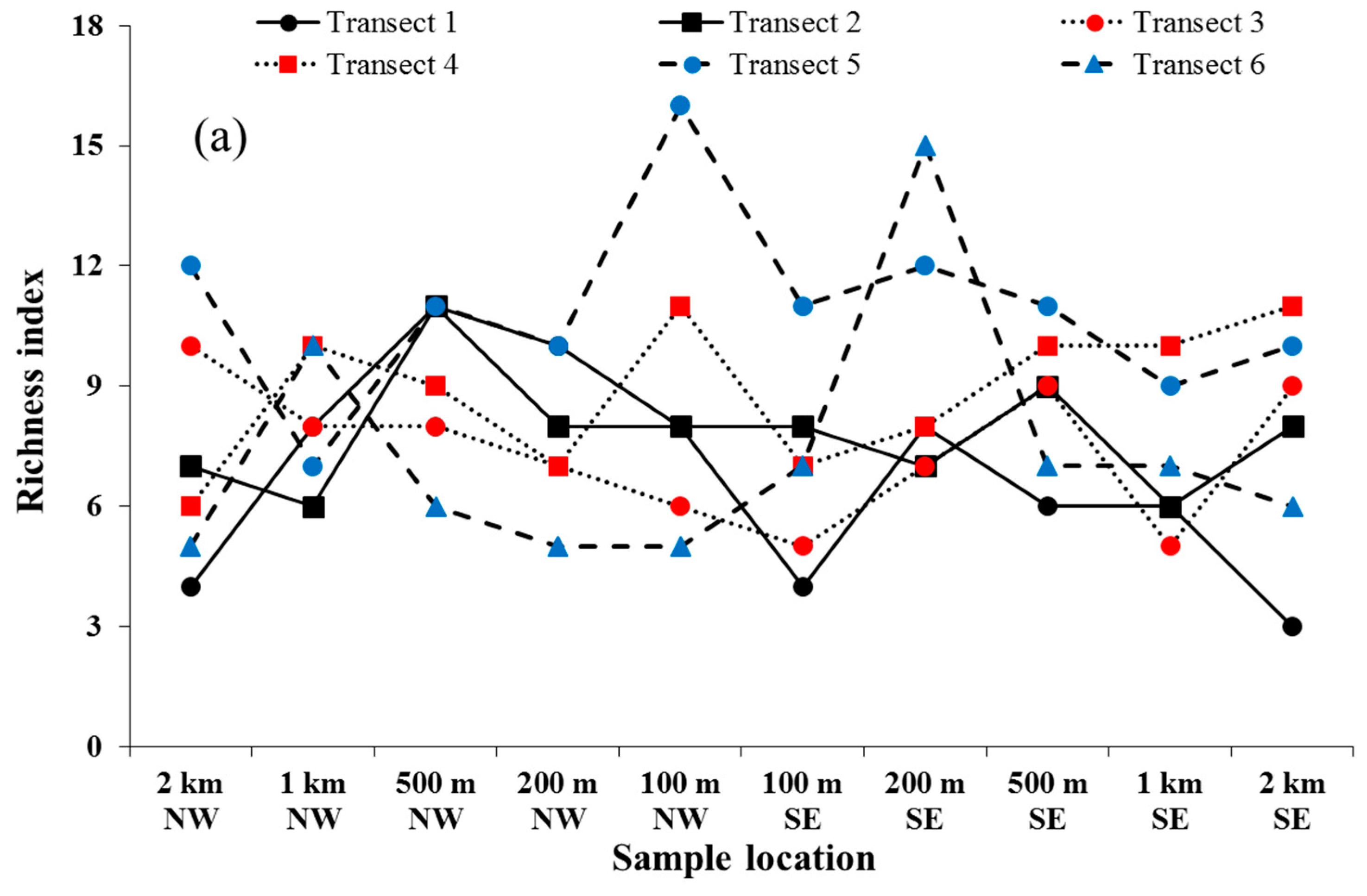
The species richness, diversity and evenness indices of the vegetation communities at 60 sampling points are shown in Figure 2. The spatial distribution curve of S (Figure 2a) can be summarized as first increasing and then decreasing with distance from the expressway. Figure 2b has shown that the high-value areas of H′ mostly appear near the expressway, while the low-value areas are far away from the expressway. The high-value areas of Jsw (Figure 2c) are not on both sides of the expressway, while the low-value areas of this index are mostly located near the expressway.
From calculating the average value of all α diversity indices of sample points at the various distances from expressway, we found that S was highest 500 m NW and 200 m SE of the expressway, with averages of 9 and 10, respectively, and was lowest 2 km NW and 1 km SE, with averages of 7. H′ was highest 500 m NW (1.870) and 200 m SE (1.829) and was lowest 2 km NW (1.623) and 1 km SE (1.674). Lastly, Jsw was highest 200 m NW (0.874) and 100 m SE (0.867) and were lowest 500 m NW (0.832) and 200 m SE (0.827). These statistical results are consistent with the spatial distribution trend of α diversity indices, the maximum of S and H′ appear 200–500 m from the expressway. The minimum of S and H′ appear 1 km away from the expressway. Unlike S and H′ the maximum of Jsw appears 100–200 m from the expressway and the minimum of Jsw is 200–500 m away from the expressway.
3.2. Soil-Moisture Content
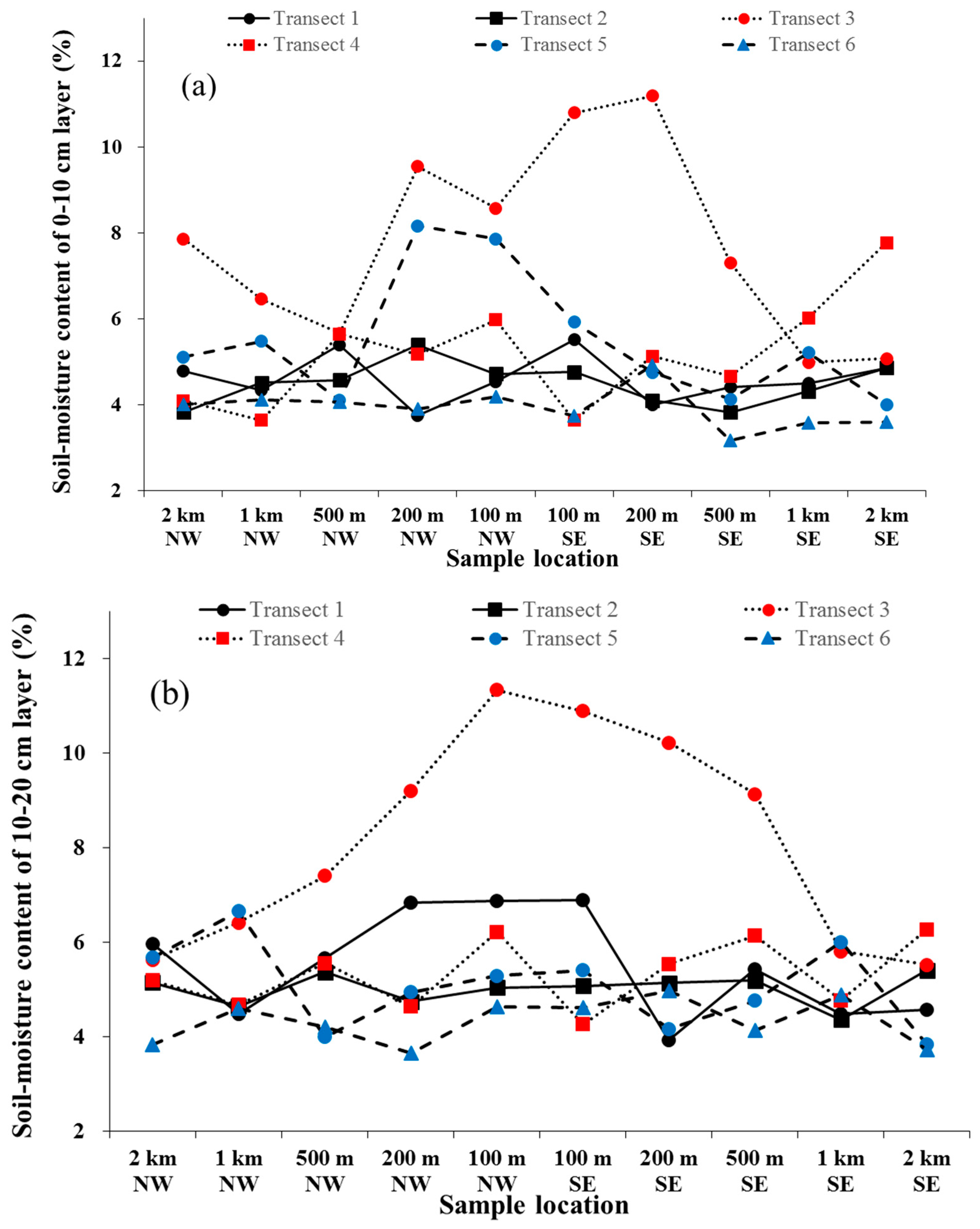
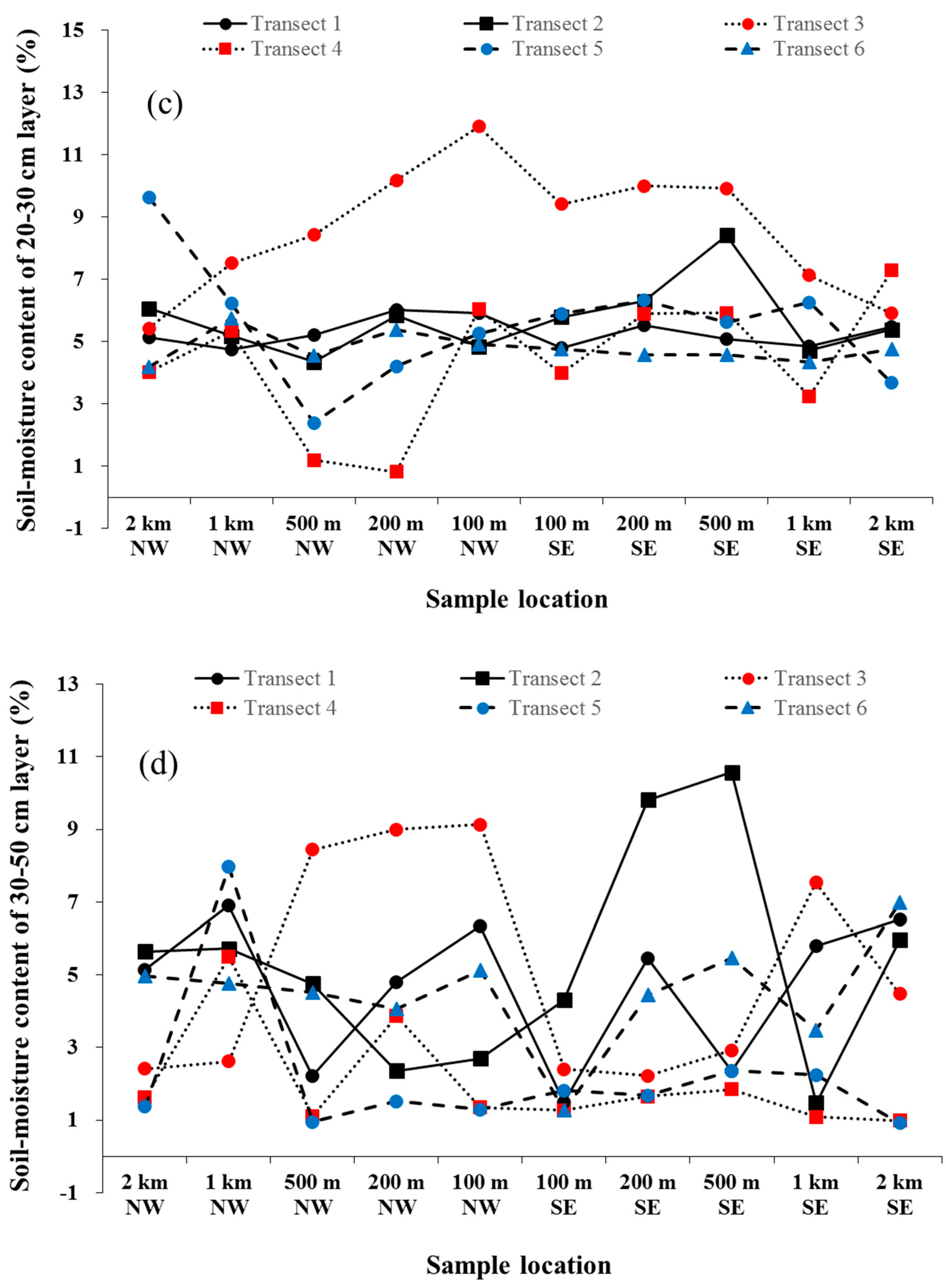
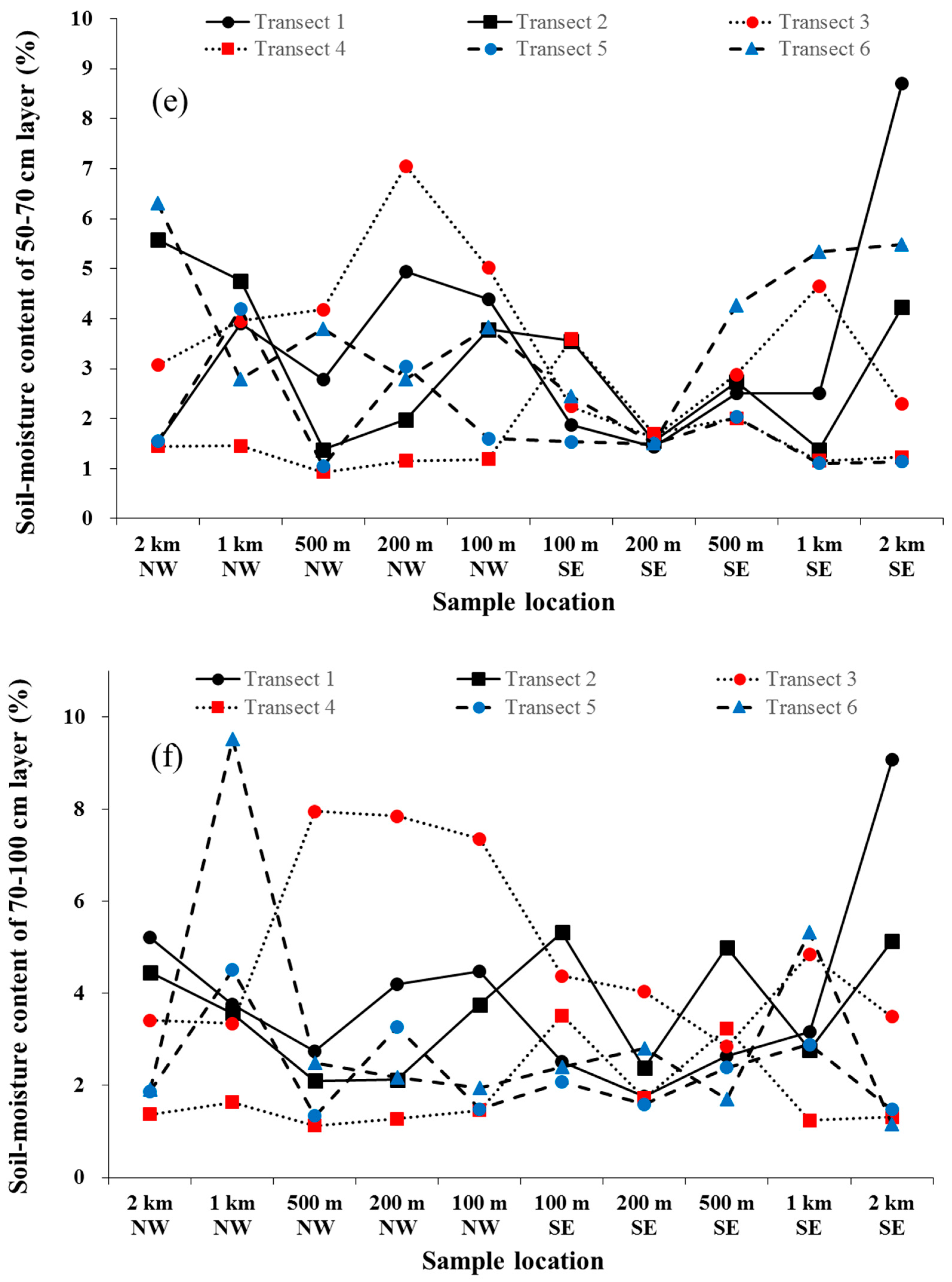
Figure 3 shows the spatial distribution of soil moisture content in the 0–10, 10–20, 20–30, 30–50, 50–70, and 70–100 cm layers. Soil moisture content in the 0–10 cm layer (Figure 3a) was highest 200 m NW and 100 m SE, with averages of 5.99 ± 2.35 and 5.73 ± 2.64%, respectively; and was lowest 1 km NW and 500 m SE, with averages of 4.77 ± 0.83 and 4.58 ± 1.43%, respectively. Soil moisture content in the 10-20 cm layer (Figure 3b) was highest 100 m NW and 100 m SE, with averages of 6.57 ± 2.47 and 6.20 ± 2.47%, respectively; and was lowest 2 km NW and 2 km SE, with averages of 5.25 ± 0.76 and 4.89 ± 1.01%, respectively. Soil moisture content in the 20–30 cm layer (Figure 3c) had no obvious peak. Soil moisture content in this layer was highest 100 m NW (6.48 ± 2.7%) and 500 m SE (6.59 ± 2.1%) and lowest 500 m NW and 1 km SE, with averages of 4.36 ± 2.50 and 5.09 ± 1.39%, respectively. Soil moisture content in the 30–50 cm layer (Figure 3d) was highest 1 km NW and 2 km SE, with averages of 5.58 ± 1.84 and 4.31 ± 2.74%, respectively; and was lowest 500 m NW and 100 m SE, with averages of 3.67 ± 2.85 and 2.09 ± 1.17%, respectively. Soil moisture content in the 50–70 cm layer (Figure 3e) was highest 1 km NW and 2 km SE, with averages of 3.51 ± 1.19 and 3.85 ± 2.93%, respectively; and was lowest 500 m NW and 200 m SE, with averages of 2.35 ± 1.43 and 1.55 ± 0.10%, respectively. Soil moisture content in the 70–100 cm layer (Figure 3f) was highest 1 km NW and 2 km SE, with averages of 4.39 ± 2.68 and 3.61 ± 3.10%, respectively; and was lowest 500 m NW and 200 m SE, with averages of 2.96 ± 2.53 and 2.38 ± 0.93%, respectively.
Note that in all the samples, soil moisture content at 20–30 cm is the demarcation point of soil moisture change with the variation of depth. Samples with higher soil moisture content above 20 cm are located within 200 m of the expressway, while the samples with lower water content are located 500 m away from the expressway. On the contrary, samples with a higher soil moisture content below 30 cm are located 1 km away from the expressway, and samples with lower soil moisture content are located within 500 m of the expressway.
3.3. Correlation Analysis of the α Diversity Indices and Moisture Content
Pearson’s correlation coefficients of the five α diversity indices for the vegetation and the soil-moisture content in different layers are presented in Table 3. Moisture content in the 0–20 cm was positively correlated with all α diversity indices. Specifically, the moisture content in the 0–10 cm was significantly positively correlated with Jsw at P < 0.05, and moisture content in the 10–20 cm was positively correlated with S at P < 0.05. Moisture content in the 20–30 cm was not significantly correlated with any α diversity indices, and the correlation between moisture content and α diversity indices were the weakest. Moisture content below 30 cm was negatively correlated with all α diversity indices. Specifically, the moisture content in 30–70 cm was significantly negatively correlated with S and H′ at P < 0.01. Moisture content in the 70–100 cm was significantly negatively correlated with H′ at P < 0.05 and significantly negatively correlated with S at P < 0.01.
The correlation analysis shows that the relationships between soil moisture content in the various layers and the α diversity indices were significantly different. There was a positive correlation between soil moisture content at the surface (0–20 cm) and the α diversity indices, but this correlation is weak. The soil moisture content below 20 cm is negatively correlated with the α diversity indices, and the correlation coefficients are higher than those associated with soil moisture content at 0–20 cm and α diversity indices. The soil moisture content in 30–70 cm has the largest correlation coefficient with the α diversity indices with an inhibitory effect occurring between them.
4. Discussion
4.1. Characteristics of Vegetation Types within Communities
Species composition varied with distance from the expressway [39]. The values of S and H′ near the expressway (200–500 m) were significantly higher than far from the expressway (1–2 km). For Jsw the maximum value occurred 100–200 m from the expressway, while the minimum value appeared 200–500 m from the expressway. This discrepancy may be related to the fact that the area near the expressway is an intensively managed strip, usually dominated by herbaceous vegetation. Plants on this strip tend to grow rapidly with moisture from road drainage [40]. Areas near an expressway contain few regionally rare species but have relatively high plant species richness [41]. Disturbance-tolerant species predominate, especially with intensive management, adjacent to expressways, and high diversity indices in this area are reasonable [42,43]. The high-value zone for the evenness indices is neighbor the expressway, while the low-value zone of it is close to the expressway. Numerous seeds are carried and deposited along roads by vehicles [44]. Plants may also spread along roads due to vehicle-caused air turbulence [45,46] in easier to reach areas near the expressway, thus affecting the evenness of plants [43,47]. The dominant wind direction in the study area is northwest except in summer; therefore, exotic species are more likely to affect the native-plant community on the southeast of the expressway, which is consistent with the lowest evenness index appearing at the southeast.
4.2. Characteristics of Soil Moisture Content
The soil moisture content at 0–20 cm was highest within 200 m of the expressway and was lowest 500 m away from the expressway. The main reason was that the impermeable pavement alters the distribution of surface water [39]. An expressway generally has an asphalt surface layer with poor permeability. Natural precipitation forms a water confluence on the road surface, then the water flows along the slope to both sides of the road. Water first permeates the shoulder and then infiltrates along the slope of the roadbed. A large amount of water can reach the excavation pit on both sides of the road and will form surface ponds in the short-term. The presence of impermeable pavement changes the distribution of precipitation on the road surface, the area adjacent to the expressway easily obtains recharge from precipitation and water storage will increase in the shallow soil. The moisture content at 0–20 cm is more susceptible to short-term water availability. The higher moisture content in this layer can facilitate the growth of vegetation near both sides of the expressway. The soil moisture content below 30 cm was lowest within 500 m
from the expressway and highest 1–2 km from the expressway. This phenomenon occurs because the water supply in the soil farther away from the expressway is limited, vegetation density and clay content in soil decreases, which leads to a reduction in water storage capacity at the surface soil and an increase in water infiltration. Therefore, water storage occurs more readily in deep soils [48]. The decrease of soil moisture content below 30 cm within 500 m from the expressway may be caused by differences in plant root distributions in the upper layer of soil [49,50].
4.3. The Relationship between Species Richness and Soil Moisture Content
The correlation analysis between soil moisture content and α diversity indices showed that the moisture content in surface soil (0–20 cm) was positively correlated with α diversity indices, soil moisture content and α diversity indices enhance each other. There was a negative correlation between soil moisture content below 20 cm and the α diversity indices, which indicates an inhibitory effect on soil moisture content and α diversity. The correlation coefficient between soil moisture content and the α diversity indices was the largest at 30–70 cm and the inhibitory effect of the α diversity indices. This is because roots of the dominant plants in this area, such as Artemisia ordosica Krasch., are distributed within high moisture content areas at 0–20 cm, so the soil-moisture content below 30 cm is not effectively used [51,52]. Field surveys indicated that the areas with high moisture content at 0–20 cm were also well vegetated, plant roots absorb water from this layer and a biologic crust is widely distributed, which influences infiltration, especially when precipitation is low [53].
5. Conclusions
In desert expressway areas, the α diversity indices for plants varied with distance from the expressway. The vegetation with high diversity and evenness were found 200–500 m NW and 100–200 m SE from the expressway. In contrast, the regions with few vegetation types and low diversity were found 1 km NW and 2 km SE from the expressway. The soil moisture content at 0–20 cm was highest within 200 m of the expressway and was lowest at 500 m from the expressway. However, the soil moisture content at 30 cm was highest 1–2 km from the expressway and lowest 500 m from the expressway. The soil moisture content in the surface soil (0–20 cm) has a significant impact on the α diversity indices, and soil moisture content below 20 cm plays an inhibitory role on the α diversity indices. The construction of the expressway has affected the distribution of surface runoff, benefitting species richness and diversity of the vegetation in the areas adjacent to the expressway and having limited effects on the areas farther from the expressway. The greatest impact of the expressway on vegetation diversity was its effect on surface runoff and the root systems of plants distributed in the upper layer of soil. However, this research also has its own insufficiencies, one example is the study only analyzed characteristics of the soil and vegetation within a limited range of the expressway. In the future, a larger range of vegetation survey could be carried out, moreover geostatistics and remote sensing images technicals could be used in the study as well [54].
Author Contributions
Z.D. conceived and designed the operation; H.C., S.S., C.L. and X.C. performed the investigation; H.C. and S.S. analyzed the data; and H.C. wrote the paper.
Funding
This research received no external funding. The authors declare no conflict of interest. The funding sources had no role in the study design, collection, analysis, or interpretation of the data or the writing of the manuscript.
Acknowledgments
The research was supported by the National Natural Science Foundation of China through grant 41701003; Natural Science Foundation of Shaanxi Province, China through grant 2018JQ4028; China Postdoctoral Science Foundation through grant 2015M582605, Shaanxi Postdoctoral Science Foundation. Shaopeng Song, Chao Li and Xujia Cui assisted with sample collection and preparation. We also thank local school authorities for their cooperation.
Conflicts of Interest
The authors declare no conflict of interest.
References
- García-Palacios, P.; Soliveres, S.; Maestre, F.T.; Escudero, A.; Castillo-Monroy, A.P.; Valladares, F. Dominant plant species modulate responses to hydroseeding, irrigation and fertilization during the restoration of semiarid motorway slopes. Ecol. Eng. 2010, 36, 1290–1298. [Google Scholar] [CrossRef]
- Forman, R.T.T. Estimate of the area affected ecologically by the road system in the United States. Conserv. Biol. 2000, 14, 31–35. [Google Scholar] [CrossRef]
- Forman, R.T.T.; Deblinger, R.D. The ecological road-effect zone of a Massachusetts (U.S.A.) suburban highways. Conserv. Biol. 2000, 14, 36–64. [Google Scholar] [CrossRef]
- Saunders, S.C.; Mislivets, M.R.; Chen, J.; Cleland, D.T. Effects of roads on landscape structure within nested ecological units of the Northern Great Lakes Region, USA. Biol. Conserv. 2002, 103, 209–225. [Google Scholar] [CrossRef]
- Jones, D.N.; Bernede, L.; Bond, A.R.F.; Dexter, C.; Strong, C.L. Dust as a contributor to the road-effect zone: A case study from a minor forest road in Australia. Australas. J. Environ. Manag. 2016, 23, 67–80. [Google Scholar] [CrossRef]
- Boarman, W.I.; Sazaki, M. A highway’s road-effect zone for desert tortoises (Gopherus agassizii). J. Arid Environ. 2006, 65, 94–101. [Google Scholar] [CrossRef]
- Semlitsch, R.A.; Ryan, J.R.; Hamed, K.; Chatfield, M.; Drehman, B.; Pekarek, N.; Spath, M.; Watland, A. Salamander abundance along road edges and within abandoned loggingroads in Appalachian forests. Conserv. Biol. 2007, 21, 159–167. [Google Scholar] [CrossRef]
- Eigenbrod, F.; Hecnar, S.; Fahrig, J.L. Quantifying the road-effect zone: Threshold effects of a motorway on anuran populations in Ontario, Canada. Ecol. Soc. 2009, 14, 24. [Google Scholar] [CrossRef]
- Theobald, D.M.; Crooks, K.R.; Norman, J.B. Assessing effects of landuse on landscape connectivity: Loss and fragmentation of western U.S. forests. Ecol. Appl. 2011, 21, 2445–2458. [Google Scholar] [CrossRef] [PubMed]
- Torres, A.A.; Palacín, C.; Seoane, J.; Alonso, J.C. Assessing the effects of a highway on a threatened species using Before-During-After and Before-During-After-Control-Impact designs. Biol. Conserv. 2011, 144, 2223–2232. [Google Scholar] [CrossRef]
- Godar, J.; Tizado, E.J.; Pokorny, B. Who is responsible for deforestation in the Amazon? A spatially explicit analysis along the Transamazon Highway in Brazil. For. Ecol. Manag. 2012, 267, 58–73. [Google Scholar] [CrossRef]
- Cai, X.; Wu, Z.; Cheng, J. Using kernel density estimation to assess the spatial pattern of road density and its impact on landscape fragmentation. Int. J. Geogr. Inf. Sci. 2013, 27, 222–230. [Google Scholar] [CrossRef] [Green Version]
- Forman, R.T.T.; Reineking, B.; Hersperger, A.M. Road traffic and nearby grassland bird patterns in a suburbanizing landscape. Environ. Manag. 2002, 29, 782–800. [Google Scholar] [CrossRef] [PubMed]
- Francis, C.D.; Ortega, C.P.; Cruz, A. Noise pollution filters bird communities based on vocal frequency. PLoS ONE 2011, 6, e27052. [Google Scholar] [CrossRef]
- Helldin, J.O.; Seiler, A. Effects of roads on the abundance of birds in Swedish forest and farmland. In Proceedings of the IENE conference on Habitat Fragmentation due to Transport Infrastructure, Infra Eco Network Europe, Brussels, Belgium, 13–15 of November 2003; On file at White River Field Office. pp. 13–14. [Google Scholar]
- Reijnen, R.; Foppen, R.; Meeuwsen, H. The effects of traffic on the density of breeding birds in Dutch agricultural grasslands. Biol. Conserv. 1996, 75, 255–260. [Google Scholar] [CrossRef]
- Rheindt, F.E. The impact of roads on birds: Does song frequency play a role in determining susceptibility to noise pollution? J. Ornithol. 2003, 144, 295–306. [Google Scholar] [CrossRef]
- Mao, X.; Wang, F.; Wang, B. Nationwide desert highway assessment: A case study in China. Int. J. Environ. Res. Public Health 2011, 8, 2734–2746. [Google Scholar] [CrossRef]
- Yan, F.; Wu, B.; Wang, Y. Estimating spatiotemporal patterns of aboveground biomass using Landsat TM and MODIS images in the Mu Us Sandy Land, China. Agric. For. Meteorol. 2015, 200, 119–128. [Google Scholar] [CrossRef]
- Huang, Y.; Wang, N.A.; He, T.; Chen, H.; Zhao, L. Historical desertification of the Mu Us Desert, Northern China: A multidisciplinary study. Geomorphology 2009, 110, 108–117. [Google Scholar] [CrossRef]
- Wang, X.; Chen, F.H.; Dong, Z.; Xia, D. Evolution of the southern Mu Us Desert in north China over the past 50 years: An analysis using proxies of human activity and climate parameters. Land Degrad. Dev. 2005, 16, 351–366. [Google Scholar] [CrossRef]
- Li, J.; Zhao, Y.; Liu, H.; Su, Z. Sandy desertification cycles in the southwestern Mu Us Desert in China over the past 80 years recorded based on nebkha sediments. Aeolian Res. 2016, 20, 100–107. [Google Scholar] [CrossRef]
- Liu, B.; Jin, H.; Sun, L.; Sun, Z.; Niu, Q.; Xie, S.; Li, G. Holocene moisture change revealed by the Rb/Sr ratio of aeolian deposits in the southeastern Mu Us Desert, China. Aeolian Res. 2014, 13, 109–119. [Google Scholar] [CrossRef]
- Saxena, S.K.; Aggarwal, R.K. Primary productivity and nutrient composition of desert grasses from a common habitat II Grass species. Indian J. Ecol. 1983, 12, 205–208. [Google Scholar]
- Narita, K.; Wada, N. Ecological significance of the aerial seed pool of a desert lignified annual, Blepharis sindica (Acanthaceae). Plant Ecol. 1998, 135, 177–184. [Google Scholar] [CrossRef]
- Editorial Committee of Chinese Flora. Chinese Academy of Sciences. Flora of China; Science Press: Beijing, China, 2004. (In Chinese) [Google Scholar]
- Inner Mongolia Botany Editorial Committee. Flora of Inner Mongolia; Inner Mongolia People’s Publishing House: Hohhot, China, 1992. (In Chinese) [Google Scholar]
- Lu, Q.; Wang, X.H.; Chu, J.M. Desert Plants in China; China Forestry Press: Beijing, China, 2012. (In Chinese) [Google Scholar]
- Wu, Z.; Zhou, Z.; Li, D.; Peng, H.; Sun, H. The areal types of the world families of seed plants. Acta Bot. Yunnanica 2003, 25, 245–257. [Google Scholar]
- Curtis, J.T.; McIntosh, R.P. An upland forest continuum in the prairie-forest border region of Wisconsin. Ecology 1951, 32, 476–496. [Google Scholar] [CrossRef]
- Lindsey, A.A. Sampling methods and community attributes in forest ecology. For. Sci. 1956, 2, 287–296. [Google Scholar] [CrossRef]
- Ayyad, M.A.; Dix, R.L. An Analysis of a Vegetation—Microenvironmental Complex on Prairie Slopes in Saskatchewan. Ecol. Monogr. 1964, 34, 421–442. [Google Scholar] [CrossRef]
- Wang, Y.S.; Shangguan, T.L. Discussion on Calculating Method of Important Values. J. Shanxi Univ. 2010, 33, 312–316. (In Chinese) [Google Scholar]
- Whittaker, R.H. Evolution and measurement of species diversity. Taxon 1972, 213–251. [Google Scholar] [CrossRef]
- Ludwig, J.A.; Reynolds, J.F. Statistical Ecology, a Primary Methods and Computing; John Wiley and Sons: New York, NY, USA, 1999; p. 337. [Google Scholar]
- Maranon, T.; Garcia, L.V. The relationship between diversity and productivity in plant communities, factors and artefacts. J. Ecol. 1997, 85, 95–96. [Google Scholar] [CrossRef]
- Oba, G.; Vitaas, O.R.; Stenseth, N.C. Relationship between biomass and plant species richness in arid zone grazing lands. J. Appl. Ecol. 2001, 38, 836–845. [Google Scholar] [CrossRef]
- Bhattarai, K.R.; Vetaas, O.R.; Grytnes, J.A. Relationship between plant species richness and biomass in an arid sub-alpine grassland of the central Himalayas Nepal. Folia Geobot. 2004, 39, 57–71. [Google Scholar] [CrossRef]
- Li, S.Y.; Lei, J.Q. Study on the vegetation restoration of the disturbance belt along the highways in the Gurbantunggut desert. Environ. Prot. Xinjiang 2002, 24, 1–7. (In Chinese) [Google Scholar]
- Forman, R.T.; Alexander, L.E. Roads and their major ecological effects. Annu. Rev. Ecol. Syst. 1998, 29, 207–231. [Google Scholar] [CrossRef]
- Bennett, A.F. Roads, roadsides and wildlife conservation: A review. In Nature Conservation 2: The Role of Corridors; Surrey Beatty and Sons: Sydney, Australia, 1991; Volume 111, pp. 99–117. [Google Scholar]
- Cale, P.; Hobbs, R. Condition of roadside vegetation in relation to nutrient status. In Nature Conservation 2: The Role of Corridors; Surrey Beatty and Sons: Sydney, Australia, 1991; Volume 111, pp. 353–362. [Google Scholar]
- Tyser, R.W.; Worley, C.A. Alien flora in grasslands adjacent to road and trail corridors in Glacier National Park, Montana (USA). Conserv. Biol. 1992, 6, 253–262. [Google Scholar] [CrossRef]
- Lonsdale, W.M.; Lane, A.M. Tourist vehicles as vectors of weed seeds in Kakadu National Park, northern Australia. Biol. Conserv. 1994, 69, 277–283. [Google Scholar] [CrossRef]
- Ross, S.M. Vegetation change on highway verges in south-east Scotland. J. Biogeogr. 1986, 13, 109–113. [Google Scholar] [CrossRef]
- Wilcox, D.A. Migration and control of purple loosestrife (Lythrum salicaria L.) along highway corridors. Environ. Manag. 1989, 13, 365–370. [Google Scholar] [CrossRef]
- Panetta, F.D.; Hopkins, A.J.M. Weeds in corridors: Invasion and management. In Nature Conservation 2: The Role of Corridors; Surrey Beatty and Sons: Sydney, Australia, 1991; Volume 111, pp. 341–351. [Google Scholar]
- Zhou, Z.B.; Li, P.J.; Xu, X.W.; Pan, B.R. Effect of artificial green belt on salt distribution in sand land in hinterland of Taklimakan Desert. J. Soil Water Conserv. 2002, 16, 126–132. (In Chinese) [Google Scholar] [CrossRef]
- Wang, J.; Liu, M.S.; Sheng, S.; Chi, X.U.; Liu, X.K. Spatial distributions of soil water, salts and roots in an arid arbor-herb community. Acta Ecol. Sin. 2008, 28, 4120–4127. [Google Scholar]
- Xue, L.I.; Guomin, L.I.; Wang, Z.M.; Shan, S.; Zhang, J.Y.; Sheng-Yu, L.I. Soil water and salt with different water table depths along the Tarim Desert Highway. Arid Land Geogr. 2013, 36, 393–399. (In Chinese) [Google Scholar] [CrossRef]
- Wang, Q.; Li, B. Preliminary study on biomass of artemisia ordosica community in ordos plateau sandland of China. Acta Phytoecol. Sin. 1994, 18, 347–353. (In Chinese) [Google Scholar]
- Zhang, J.; Wu, B. Influences of biological soil crusts on physicochemical properties of soil in artemisia ordosica and sabina vulgaris communities. J. Northeast For. Univ. 2012, 40, 58–61. (In Chinese) [Google Scholar]
- Zhang, J.H. Distribution characteristics of biological soil crust for artemisis ordosica community in mu us sandy land. Bull. Soil Water Conserv. 2014, 34, 227–230. (In Chinese) [Google Scholar] [CrossRef]
- Zawadzki, J.; Cieszewski, C.J.; Zasada, M.; Lowe, R.C. Applying geostatistics for investigations of forest ecosystems using remote sensing imagery. Silva Fenn. 2005, 39, 599–617. [Google Scholar] [CrossRef]
Figure 1.
Map of the study area with the location of sampling transects and a sketch of the transect.
Figure 1.
Map of the study area with the location of sampling transects and a sketch of the transect.

Figure 2.
The α diversity indices of the plants along the Yujing Expressway. (a) Richness index; (b) Shannon–Wiener index; (c) Pielou index.
Figure 2.
The α diversity indices of the plants along the Yujing Expressway. (a) Richness index; (b) Shannon–Wiener index; (c) Pielou index.


Figure 3.
The soil moisture content of 0–100 cm sandy soil along the Yujing Expressway. (a) 0–10 cm layer; (b) 10–20 cm layer; (c) 20–30 cm layer; (d) 30–50 cm layer; (e) 50–70 cm layer; (f) 70–100 cm layer.
Figure 3.
The soil moisture content of 0–100 cm sandy soil along the Yujing Expressway. (a) 0–10 cm layer; (b) 10–20 cm layer; (c) 20–30 cm layer; (d) 30–50 cm layer; (e) 50–70 cm layer; (f) 70–100 cm layer.


Table 1.
Plant communities in the study area.
| Transect | Plant community |
|---|---|
| 1 | Artemisia ordosica Krasch., Heteropappus altaicus (Willd.) Novopokr., Hedysarum mongolicum Turcz., Corispermum candelabrum Iljin |
| 2 | Artemisia ordosica Krasch., Heteropappus altaicus (Willd.) Novopokr., Salix psammophila C. Wang & Chang Y. Yang, Cynanchum hancockianum (Maxim.) Iljinski |
| 3 | Artemisia ordosica Krasch., Poa annua L., Calamagrostis pseudophragmites (Haller f.) Koeler., Caragana korshinskii Kom., Wikstroemia chamaedaphne (Bunge) Meisn., Chenopodium aristatum L. |
| 4 | Artemisia ordosica Krasch., Heteropappus altaicus (Willd.) Novopokr., Poa annua L., Calamagrostis pseudophragmites (Haller f.) Koeler., Corispermum candelabrum Iljin, Hedysarum scoparium Fisch. & C.A.Mey. |
| 5 | Artemisia ordosica Krasch., Heteropappus altaicus (Willd.) Novopokr., Salix psammophila C. Wang & Chang Y. Yang, Caragana korshinskii Kom., Melilotus suaveolens Ledeb., Cynanchum thesioides (Freyn) K.Schum. |
| 6 | Artemisia ordosica Krasch., Heteropappus altaicus (Willd.) Novopokr., Hedysarum mongolicum Turcz., Calamagrostis pseudophragmites (Haller f.) Koeler., Setaria viridis (L.) P.Beauv. |
Table 2.
Importance values (IVs) of the main plants along the six transects (T) (only IVs > 0.1 are shown).
Table 2.
Importance values (IVs) of the main plants along the six transects (T) (only IVs > 0.1 are shown).
| Biotype | Plant Name | Family | T1 | T2 | T3 | T4 | T5 | T6 |
|---|---|---|---|---|---|---|---|---|
| Shrubs and subshrubs | Artemisia ordosica | Asteraceae | 0.35 | 0.39 | 0.23 | 0.26 | 0.23 | 0.26 |
| Salix psammophila | Salicaceae | 0.11 | 0.20 | 0.11 | ||||
| Caragana korshinskii | Leguminosae | 0.11 | 0.14 | 0.10 | ||||
| Hedysarum mongolicum | Leguminosae | 0.13 | ||||||
| Hedysarum scoparium | Leguminosae | 0.10 | 0.11 | |||||
| Lespedeza davurica | Leguminosae | 0.11 | ||||||
| Wikstroemia chamaedaphne | Thymelaeaceae | 0.11 | ||||||
| Perennial herbs | Heteropappus altaicus | Asteraceae | 0.21 | 0.10 | 0.10 | 0.11 | ||
| Cynanchum hancockianum | Asclepiadaceae | 0.11 | ||||||
| Cynanchum thesioides | Asclepiadaceae | 0.12 | ||||||
| Astragalus melilotoides | Leguminosae | 0.13 | ||||||
| Bassia dasyphylla | Chenopodiaceae | 0.12 | ||||||
| Calamagrostis pseudophragmites | Poaceae | 0.12 | 0.11 | |||||
| Annual herbs | Corispermum candelabrum | Chenopodiaceae | 0.13 | 0.10 | ||||
| Chenopodium aristatum | Chenopodiaceae | 0.10 | ||||||
| Setaria viridis | Poaceae | 0.13 | ||||||
| Annual/biennial herbs | Melilotus suaveolens | Leguminosae | 0.11 | |||||
| Poa annua | Poaceae | 0.10 | 0.15 |
Table 3.
Pearson’s correlation matrix for the vegetation indices and soil-moisture content.
| S | H′ | Jsw | 0–10 cm | 10–20 cm | 20–30 cm | 30–50 cm | 50–70 cm | 70–100 cm | |
|---|---|---|---|---|---|---|---|---|---|
| S | 0.000 | 0.562 | 0.463 | 0.482 | 0.781 | 0.006 | 0.000 | 0.023 | |
| H′ | 0.885 ** | 0.002 | 0.173 | 0.925 | 0.631 | 0.001 | 0.000 | 0.007 | |
| Jsw | 0.076 | 0.392 ** | 0.040 | 0.323 | 0.860 | 0.192 | 0.560 | 0.823 | |
| 0–10 cm | 0.097 | 0.178 | 0.266 * | 0.000 | 0.000 | 0.322 | 0.710 | 0.150 | |
| 10–20 cm | 0.093 * | 0.012 | 0.130 | 0.783 ** | 0.000 | 0.279 | 0.465 | 0.002 | |
| 20–30 cm | −0.037 | −0.063 | −0.023 | 0.558 ** | 0.757 ** | 0.009 | 0.089 | 0.000 | |
| 30–50 cm | −0.349 ** | −0.428 ** | −0.171 | −0.130 | 0.142 | 0.333 ** | 0.000 | 0.000 | |
| 50–70 cm | −0.469 ** | −0.513 ** | −0.077 | −0.013 | 0.186 | 0.276 * | 0.587 ** | 0.000 | |
| 70–100 cm | −0.292 * | −0.344 ** | −0.030 | 0.235 | 0.401 ** | 0.487 ** | 0.544 ** | 0.609 ** |
The lower-left figures are correlation coefficients, and the upper-right figures are P values. ** Correlation is significant at P < 0.01 (two-tailed). * Correlation is significant at P < 0.05 (two-tailed).
© 2019 by the authors. Licensee MDPI, Basel, Switzerland. This article is an open access article distributed under the terms and conditions of the Creative Commons Attribution (CC BY) license (http://creativecommons.org/licenses/by/4.0/).
Share and Cite
MDPI and ACS Style
Chen, H.; Dong, Z.; Song, S.; Li, C.; Cui, X. Characteristics of the Soil and Vegetation along the Yulin–Jingbian Desert Expressway in China. Sustainability 2019, 11, 606. https://0-doi-org.brum.beds.ac.uk/10.3390/su11030606
AMA Style
Chen H, Dong Z, Song S, Li C, Cui X. Characteristics of the Soil and Vegetation along the Yulin–Jingbian Desert Expressway in China. Sustainability. 2019; 11(3):606. https://0-doi-org.brum.beds.ac.uk/10.3390/su11030606
Chicago/Turabian StyleChen, Hao, Zhibao Dong, Shaopeng Song, Chao Li, and Xujia Cui. 2019. "Characteristics of the Soil and Vegetation along the Yulin–Jingbian Desert Expressway in China" Sustainability 11, no. 3: 606. https://0-doi-org.brum.beds.ac.uk/10.3390/su11030606
Note that from the first issue of 2016, this journal uses article numbers instead of page numbers. See further details here.