Article

A Detailed Identification of Erosionally Endangered Agricultural Land in Slovakia (Case Study of Nitra Upland)

by
Lucia Petrikovičová
1,*,
Zuzana Rampašeková
1 and
Jaroslava Sobocká
2
1
Department of Geography and Regional Development, Faculty of Natural Sciences, Constantine the Philosopher University in Nitra, 94974 Nitra, Slovakia
2
Soil Science and Conservation Research Institute, National Agricultural and Food Centre, 82109 Bratislava, Slovakia
*
Author to whom correspondence should be addressed.
Sustainability 2020, 12(12), 4863; https://0-doi-org.brum.beds.ac.uk/10.3390/su12124863
Submission received: 18 May 2020 / Revised: 10 June 2020 / Accepted: 11 June 2020 / Published: 15 June 2020
(This article belongs to the Special Issue Soil Erosion and the Sustainable Management of the Landscape)

Abstract

:
Water erosion and its processes are the most widespread and serious degradation phenomena in Slovakia (occurring in about 37% of the agricultural land). Given the increasing use of precise land management, it is necessary to have more detailed databases, especially in erosion-accumulation areas. The aim of the research was to identify in detail the areas of erosion-accumulation processes induced by water erosion, which can be considered as highly heterogeneous. In the territory of the Nitra upland the field survey methodology and grid mapping were used, the results of which were verified through soil erosion models. The mapping was done at the topic level and was verified using the USLE and ERDEP soil erosion models in ArcGIS. A comparison of the results of the potential model and real field parameters of soil erosion in the Nitra upland enabled us to generate dominant factors, respectively identify areas prone to soil erosion, and provided a detailed database for precise farming. At the same time, the results became the basis for a review of the current classification by erosion endangered soils. Overall, the methodology is suitable as a basis for developing sustainable management proposals in agricultural land affected by soil erosion risk.

1. Introduction

Soil is an essential natural resource, ensuring the maintenance of socio-economic and ecological systems on Earth. These systems do not serve only as a source of food and raw materials for the inhabitants of the Earth (production and non-production soil functions), but have always indicated the localization of human settlements and infrastructure—the main factors of regional territory development. Since time immemorial, it has determined the appearance of the country and has kept the testimony of a man of the past; it is a very important part of cultural heritage. Despite the irreplaceable role it performs, its main meaning and function are not fully appreciated. The changes that show the soil’s resistance to both natural and anthropogenic influences should make us much more concerned with its protection. Anthropogenic impact on soil is manifested mainly by intensive agricultural land use. Inadequate soil management causes a number of degradation processes, among which soil erosion has a special position. It causes the release, relocation, and accumulation of soil mass or even geological material in already slightly sloping terrains. As stated by [1] it manifests itself by continuous movement of soil mass in the direction of gravity and can be very dangerous for soil management. In some cases, erosion is considered a natural hazard, which can result in the complete degradation of land to produce a derelict area [2,3].
In terms of the work of [1] the Soil Fund of Slovakia belongs to four areas of influence of erosion processes. Nitra upland, part of which is the subject of our research, is classified into a highly eroded area. Rainwater appears to be the dominant erosive factor, the intensity of which increases depending on the natural, but mainly anthropogenic, effects of the action. The effects of sudden tidal storms that have been the result of emerging climate change in recent years have to be added.
Soil erosion research in recent decades in Slovakia has been carried out by many authors, especially [1,4,5,6]. Great emphasis on preventing the effects of water erosion activity by modeling soil erosion (which makes it possible to anticipate erosion and prevent soil erosion) was presented by the Slovak authors [7,8]. Foreign authors dealt with this issue, especially [9,10]. Landscape modeling as well as regional development issues are discussed in [11,12,13,14] and others. Application of the detailed geoecological research, for use by the identification of natural elements of terroir, is here based on the example of Slovakia. The characteristics of georelief and soil characteristics are the most important elements of a terroir on a local scale [15,16,17].
The aim of the present paper is to identify in detail areas prone to soil erosion on a topic level, (grid mapping) and using the models USLE and ERDEP to verify the results of field research. We expect that by comparing the results of field research with individual characteristics of the territory i.e., input data of the model, we will be able to specify areas susceptible to soil erosion in dependence on the acting dominant conditions. Based on the obtained results, we evaluated the change of soil cover due to erosion-accumulation processes, re-evaluated and classified the current state of soil cover, and evaluated measures that would lead to a reduction of negative impacts on agricultural land. The contribution methodology can be used as a suitable basis for the elaboration of proposals for sustainable management by erosion endangered agricultural soils. The original methodology is proposed for a large area (regional level), we applied it to a small area (topic level), and so we proved that it works at this level and is applicable to different types of territory and landscape. It could be used in detailed field research. It is likely that ill-considered methods of soil management in the current socio-economic conditions can cause irreversible effects on the quality and quantity of land resources, and land can cease to be a natural productive resource for future generations.

2. Materials and Methods

2.1. Characteristics of Selected Soil Area

The selected mapped area, with an area of 36.77 ha, is located in the agricultural landscape of the villages of Rišňovce and Rumanová and marginally touches the village of Velké Zálužie (Figure 1). Administratively, it belongs to the Nitra region and Nitra district. It can be divided into two parts because of the management of two entities—the eastern part, which is managed by Agrodružstvo Rišňovce, and the western part, which is managed by the Farming Cooperative Rumanová. In the country, this limit is determined by a small stand of trees. Geologically, this limit lies on the boundary of Quaternary loess and Neogene sediments. Geomorphological setting belongs to the part of Zálužianska upland, which is a part of the Nitra upland. In terms of relief, the mapped area can be divided into three parts. The highest point represents the top part with the platform. It is situated in the north-eastern part of the territory of interest, at an altitude of 220 m. The second part consists of a slope, with a slope in the upper part of 3–7°, in the middle part of 7–12°, and in the lower part again of 3–7°, with mostly SW orientation. The slope is bounded from the west and south by a valley whose altitude is 160 m. The elevation of the mapped area is thus 60 m a.s.l. It climatically belongs to the warm, very dry, lowland region. The distribution area of the two catchment areas of the Nitra and Váh rivers passes through the mapped area. The territory lies on the boundary of Haplic Chernozems and Haplic Luvisols and is pedogeographically complicated, i.e., pedodiversity occurs at intervals of several tens of meters. Soils are used for growing crops, focusing on fodder and cereals.

2.2. Terrain Soil Mapping and GIS Processing

Field grid soil research was carried out in accordance with standard soil mapping procedures designed in [18]. It was compiled by the authors [19]. On the contour line base there was created the network (grid) of 111 soil probes equally spaced by about 70 m (Figure 2). On average there were 3 probes per 1 ha, which is confirmed by detailed mapping at a scale M: 1:10,000. The probes were drilled with Edelman’s soil drill to a depth of 120–130 cm, respectively, after reaching the soil-forming substrate. In ArcGISTM, each point in the network has been co-ordinarily identified by its geographic location. In the field, each point was searched by using GPS type eTrex Venture Cx. The localization of soil probes was digitized in ArcGISTM and a vectorized georeferenced data layer was created. The conception of elementary forms of georelief, which uses relief in the form of a boundary-forming factor [20,21,22,23], was used for processing the results of field mapping and delimitation of erosion-accumulation areas. The analysis of the morphometric properties of the georelief (Figure 3) was created on the basis of the digital relief model (DMR). The basis for its construction were topographic maps M: 1:10,000 (map sheets 35-34-24 and 45-12-04), which were orto-rectified into the coordinate system S-JTSK (Křovák). By the software R2V (© Albe Software Corp, Bratislava, Slovakia) was created contour vectorization raster layers and by ArcGISTM (© ESRI, Bratislava, Slovakia) was generated input field altitudes. Based on DMR, morphometric parameters of the surface were generated such as slope, orientation (exposure), normal (slope) surface curvature, and horizontal (contour) surface curvature, in ArcGISTM by Spatial Analyst and stored as a raster data layer (Figure 3). Based on the expert visual analysis of DMR, there were generated areas of elementary forms of relief. In light of the above analysis, sudden changes in relief in the form of slope, horizontal, and normal curvature, as well as exposure, were taken into account. Obtained boundaries of the areas of elementary forms of the surface were finally adjusted on the basis of field verification and correction.

2.3. Soil Erosion Models

Computer models are applications (programs) that are used to predict the potential behavior of a country. In terms of country studies, simulation modeling represents a dedicated system of input data and knowledge of the particular country, thanks to which it is possible to model its selected aspects [24].
In practice, water erosion modeling through the USLE universal soil loss equation is still the most widely used method. It belongs to the empirical models derived from measurements in the field or laboratory and statistical processing. The basic equation has been modified several times (RUSLE, MUSLE, etc.) and adjusted to the conditions of Slovakia. At present, it is the way to replace this model with more complex models that would better characterize the process itself. For example, the USLE method only deals with soil removal from a given location on a slope; it also does not consider sedimentation and soil benefits from higher slopes. Among the models that also solve sedimentation, belongs, for example, the dynamic model based on physical basis ERDEP—Erosion Deposition. Besides these differences in the features of the models, both offer a number of advantages as an interface with GIS (easier to include diversity in the calculations), such as acceleration calculations for large areas (these cases have enough valuable quality digital map data and information layers), detailed and developed input factors, and efficient and easy presentation of results. Analysis of advantages and disadvantages, resp. Weaknesses of individual models are mentioned in the article [22]. These were disproved in the work of [25] and thanks to the research, research was carried out on a topical level (Nitra upland on the property with heterogeneous input data—subsoil, relief, soil, and vegetation).

2.3.1. Model USLE

Created by [9]. It is one of the basic and most widely used models to assess potential erosion intensity. The relation to the calculation of erosive drift is expressed by the universal soil loss equation (USLE):
G = R × K × L × S × C × P
It is expressed by the indicator (G) of the average long-term soil loss (t·ha−1·r−1) dependent on the R-factor of rain erosion efficiency (MJ·ha·cm·h), K—the soil erodibility factor (t·ha), L—slope length factor (m), S—slope factor, C—vegetation protection factor, and P—erosion control efficiency factor.

2.3.2. Model ERDEP

It is one of the possible solutions of water erosion simulation, more fully characterized in the works. It is based on the application of the theory of unitary power flow and the theory of physical fields in the GIS environment. It is a calculation of sediment flow per unit width of flow (kg·m−1·s−1) at a given point and time, and subsequently a calculation of the intensity of erosion or accumulation (kg·m−2·s−1). The model is based on the physical nature of the erosion-accumulation process and applies to a specific moment of time and is applicable to individual precipitation events significant in terms of erosion and accumulation. It is based on the relief impact (by means of the inclination, orientation, and normal curvature in the direction of the down curve of a normal curvature in the direction of the tangent to the contour line), vegetation (braking performance plant cover), and the properties of soil elements (median diameter of the sedimentation of the elements, the sedimentation rate of the transmitted particles, the depth of water, relief slope, and kinetic viscosity of water).
Originally, the methodology of the USLE and ERDEP models was proposed for a large area (e.g., the whole of Europe). We have verified this methodology to a small area (topical level) and this methodology has been proved. Therefore, we consider that the methodology can also help in the detailed mapping of a small area.

3. Results

Based on theoretical knowledge, grid field research, and the modeling of soil erosion, we found that in the area of interest expressed in terms of work [26], flat (areal) erosion by direct human impact to the soil according to [1] passed to direct anthropogenic erosion, respectively of erosion [27,28,29,30,31]. It is manifested by the occurrence of erosion, accumulation, or overlapping areas.

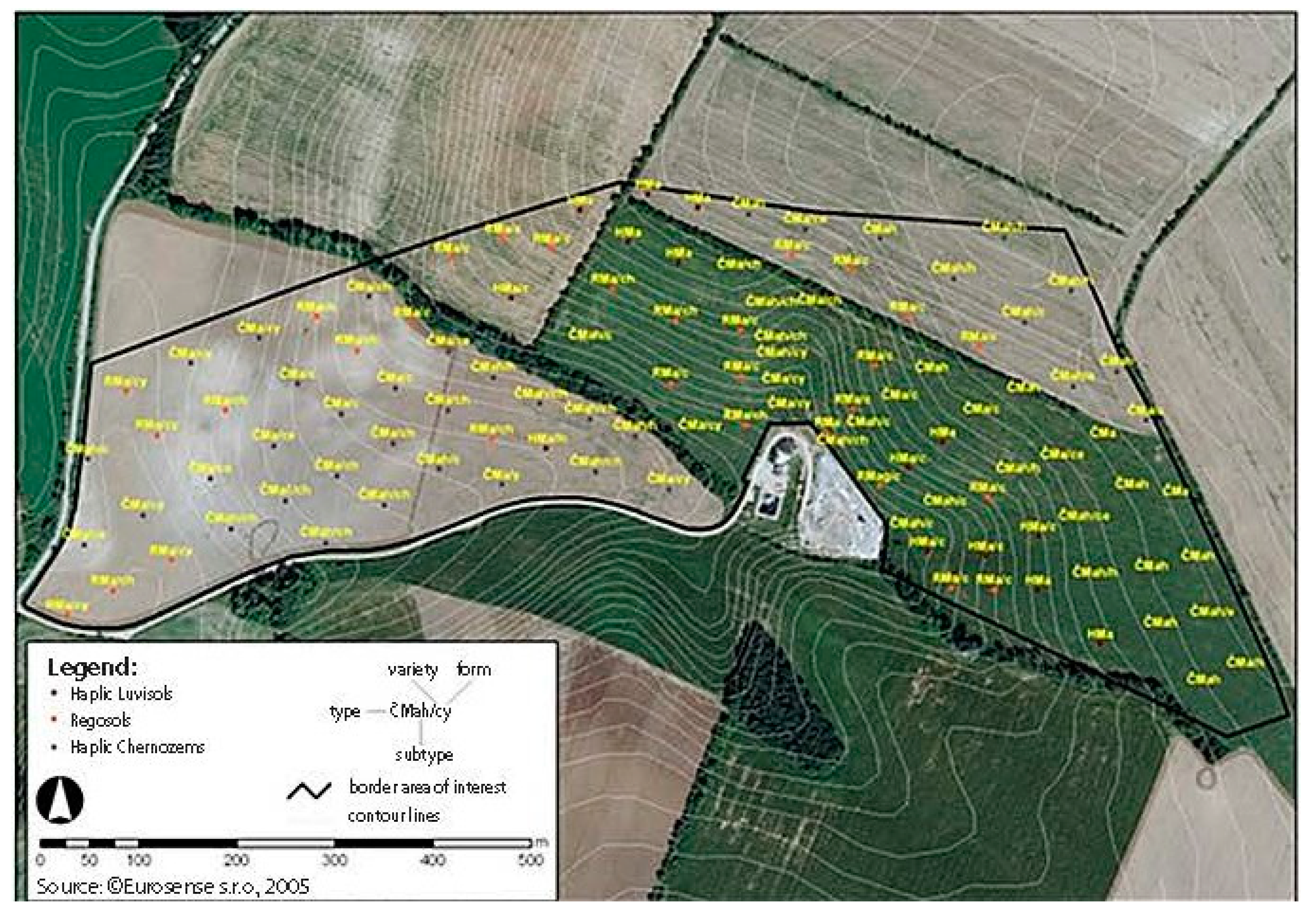
3.1. Field Soil Research

A detailed analysis of the results of field mapping showed that the whole area of interest is affected by surface water erosion. In order to identify areas with the strongest erosion activity, and consequently dominant factors and conditions increasing the intensity of erosion activity, we modified the boundaries of topsoil horizon and created a map of the areas of elementary forms of geo-relief of the area of interest (Figure 4).
This section may be divided by subheadings. It should provide a concise and precise description of the experimental results, their interpretation, as well as the experimental conclusions that can be drawn.
Real erosion-accumulation processes taking place in the model area are presented by a map of erosion-accumulation areas. Created areas were identified in terms of SPS (2014), [18] eroded in soil form (E), accumulated (H), overlapped (Y), and bounded by elementary forms of georelief. They were identified on the basis of the depth of the surface humus horizon (A—horizon) of individual soil types. The average depth of the A—horizon of Chernozems (CM) was 50 cm, with Arenosols (RM) at 33 cm, and Luvisols (HM) at 28 cm. We found that almost all soils on slopes with a slope less than 3° were accumulated and eroded on slopes with a slope greater than 3°. Similar research results, in which there were significant manifestations of erosion in moderately rugged upland parts, were documented by [10]. To identify dominant factors, respectively, under the conditions of erosion activity the average depths of humus horizons of individual soil types were determined as follows:
  • CM: CM/e—eroded: <40 cm, CM/h—accumulated: >50 cm, CM/y—overlapped: 120 cm,
  • RM: RM/e—eroded: <20 cm, RM/h—accumulated: >30 cm, RM/y—overlapped: 120 cm,
  • HM: HM/e—eroded: <20 cm, HM/h—accumulated: >30 cm.
Border treatment has identified areas with the most intense potential for water erosion. In fact, erosive areas of ČMa (Chernozems) with a depth of humus horizon of less than 40 cm were generated. Their area was 3.12 ha, which is 7% of the territory. They were created on loess, on slopes with a 3–7° gradient, and on convex-convex (VV) forms of relief.
Subsequently, a significant proportion of accumulated areas (H) was found: up to 30% of the area (10.95 ha). They are covered not only with accumulated forms of ČMa, but also RMa and HMa on slopes with a slope of 3–7°. From the morphometric point of view, they bind to the concave-concave (KK) to concave-convex (KV) forms of relief in the western part of the area of interest, i.e., on a slope of greater length, with a predominantly homogeneous substrate. In the eastern to south-eastern part, on a slope of shorter length, with non-homogeneous backing material, they bind to convex-linear (VL) and in some cases convex-convex (VV) forms of relief. However, this result contradicts the generally accepted theory of soil accumulation. According to the authors [32,33,34,35,36,37], on VV and VL forms erosion processes occur, not accumulation. This can be explained by a sudden change in slope and a change in the graininess of the clay-to-clay substrate. The second hypothetical option would be the fact that the whole eastern part of the territory was in the past naturally formed by very deep, perhaps 100 cm, Chernozems, as we identified two Chernozems areas with a humus horizon depth over 60 cm in the top part with flat relief.
A more intensive accumulation process created overlapped areas (Y) of ČMa and RMa with a depth of humus horizon of approximately 120 cm, with an area of 5.07 ha, which is 13% of the area of interest. These areas were formed on loess and colluvial alluviums of long bottom forms of slopes bounding the western and southern part of the area of interest, with a gradient of 1–3°, but also depressed in the central part, with a slope of 3–7°. According to the Morphogenetic Soil Classification System (SPS 2014), some of them had to be mapped as Regosols, although the stratification of soil profiles showed that it was a coluvial material overlapping the humus horizon, and so rather Coluvisols as proposed by [38,39]. From a morphometric point of view, the sites in depressed forms bind (overlapping) exclusively to concave-concave (KK) forms of relief. The findings are in agreement with [1] who reports that the slope and transport capacity increase with the length of the slope and that there is an increased accumulation of soil material in the lower part, i.e., overlapping.

3.2. Determination of the Intensity of Potential Erosion by USLE and ERDEP Models

The model of potential intensity of erosion was solved based on interrelations of factors of rain erosion efficiency (R), soil erodibility (K), slope length and slope (LS), vegetation protection (C), and erosion control (P) in the sense of [25]. It was found that the intensity of erosion activity increases in the SW direction and the whole central part shows a high potential for erosion activity. Since the USLE model was determined for the topical level, the reliability of its results were verified by the ERDEP model. This almost identical model delimited erosive areas using the diffuse boundaries of soil areas. For the benefit of this model, we consider that it evaluates the accumulation of positive figures and erosion negative figures (Figure 5).
For the categorization model territory we used the four categories of average annual soil loss referred to in [40]; 11.46 ha (31.2%) of the total area of the land is included in the category of no to slight land loss. In the category of medium soil loss it is 7.84 ha (21.3%), in the category of high soil loss it is 14.98 ha (40.7%), and in the category of extreme soil loss it is 2.49 ha (6.8%). For the category of extreme soil loss we recommend to check the form of relief. In the case of concave (depressed) forms it is the accumulated material of the topsoil that identifies the overlapped forms of soil types. The strength of the model USLE is an illustration of the sharp border area, which is more applicable to real use.

3.3. Identification of Dominant Factors and Conditions

The origin, course, and intensity of erosion is influenced by natural and anthropogenic factors. There are five groups of factors that influence erosion processes on agricultural land: climatic and hydrological, geological and soil, morphological, vegetational, and factors regarding the way of soil management.
The first group of climate and hydrological changes has not been taken into account in the analysis of factors as it is a small area with climatically homogeneous conditions.
Groups of geological and soil factors are also understood as homogeneous. Almost the entire area of 90% (33.08 ha) consists of dust-loamy loess, only a small part of 5% (1.98 ha) of polygenetic and loess sediments, 2% (0.62 ha) of coluvial sediments, and 3% (1.09 ha) Neogene (limnic to brackish) sediments. We believed that the factor belonging to that group would have a negligible impact on water erosion. However, field research has shown that 3% of the area formed by neogene clayey sediments caused a sudden change in graininess and skeleton, and in our case up to 10% in topsoil and subsoil. This means that soil conditions in a given area alleviate, and in some cases even eliminate, erosion processes and have high efficiency.
Based on previous analyses, we considered the group of geomorphological conditions to be dominant, affecting the intensity of water erosion activity. The relief feature that most intensively affects erosion-accumulation processes in the monitored area has been identified. The digital relief model (DMR) made it possible to observe five relief features: hypsometry, slope, exposure, horizontal, and normal curvature. In terms of morphometric characteristics we have not considered as dominant:
  • altitude, since the elevation reached only 60 m above sea level,
  • exposure that is the whole area mostly south-west oriented,
  • horizontal curvature, in which the material is concentrated in the concave relief forms and the accumulation process occurs.
The most significant influence of the morphometric properties of the relief appeared to be the relationship between the slope and the vertical (normal) curvature of the relief. Based on the works of [41,42,43,44,45], slopes with a slope greater than 3° show susceptibility to soil erosion. Therefore, our focus has been on the 3–12° slopes. From the geological data it was found out that the subsoil of the slopes with the highest slope of 7–12° in the eastern part of the mapped area is formed by neogene clayey sediments, the occurrence of which was also confirmed by field research. Therefore, we thought that in the field survey these soils would not show extreme erosion as suggested by the model. This hypothesis was confirmed. It has been shown that sudden changes in grain and skeleton, in our case up to 10% in topsoil and subsoil, alleviate and in some cases even eliminate erosion processes. We, therefore, agree with the work of [4,46] who claim that soil with a higher slope and higher clay content appears to be less eroded than soil with a lower slope and lower clay content. Cartographic processing of the results of this field survey were generated in the eastern part of three smaller erosion areas with a slope of 3–7° with convex normal curvature relief. These areas were created at the transition of the inclination of the relief. Two erosion sites were created in the western part.
Based on the use of morphometric methods of research soil erosion [26], we state that the relief is a significant condition affecting the intensity of erosion. By DMR in the study area we have generated delimitation areas with the highest potential for erosive activity. Subsequently, we identified dominant conditions of erosive activity, which are the slope and slope curvature, not the vertical curvature of long slopes. According to them, slopes with a slope of 3–12° on convex forms of relief should have the greatest potential for erosion. The first three groups point to the factors and conditions of a natural character. The last two groups of vegetation and the way of land management are anthropogenic. The factors of these two groups can significantly increase the environmental impact and thus contribute to reducing erosion, in particular by applying sustainable land management. However, the mapping revealed that crops with low erosion efficiency of broad-row zea maize crops and crops with good erosion efficiency of narrow-grain cereal crops were mostly grown in areas with a high slope of 3–12°. In accordance with the anti-erosive crop rotation method for maize cultivation, it was appropriate to use the possibility of pitting the soil surface or other roughening of the surface. However, we did not identify these practices during the research.

4. Discussion

Proposals for Soil Protection

There are several ways to implement sustainable land management practices that contribute to reducing negative impacts on agricultural land. These include the maintenance of good soil environmental conditions that have been implemented under GAEC—Good Agricultural and Environmental Conditions under the EU Common Agricultural Policy. The GAEC requirement refers to a series of standards captured in the new programming period 2014–2020 in the Rural Development Program, which aims, inter alia, to promote sustainable land management and ensure the protection of soil from degradation.
Based on the research we have confirmed that slope tendency has the greatest influence on the intensity of erosion. Intensive land use is also realized on slopes with an inclination of 7–12°. Erosion protection of the soil is not respected on the areas with the mentioned tendency. This approach is contrary to the principles of optimal and sustainable use of arable land, because such slopes require the consistent application of anti-erosion practices. It has been found that crops with low erosion efficiency of broad-row maize crops and those with good erosion efficiency of narrow-grain cereal crops have been grown in areas with an inclination between 3–12°. Crops with long erosion effects should be grown on the mapped areas exposed to erosion throughout the vegetation period. These are crops such as clover grasses, grassland, winter crops, peas, common beans, and so on. It also expects strict cultivation to contour machining, or other appropriate agronomic practices in terms of work [34,35,36,37].
Use of good agronomic practices and mechanisms in Europe and the world in relation to soil erosion has been addressed by more authors. They investigate the short term effects of animal manure application on soil structure stability, infiltration rate, and runoff and soil erosion formation under rainfall conditions [47,48]. The comparison of the influence of physical-geographical conditions on soil erosion and its impact on the examples of different localities was conducted by [49]. The revised universal equation of the USLE model was similarly addressed in their contributions, for example of the Kongo Republic [50] and Spain [51]. The impact of vegetation on soil erosion processes in Slovakia [52] and Poland [53] has also been addressed by some authors. Another method to evaluate soil erosion is the USPED method. The comparative analysis shows the interrelations between the soil loss by erosion and the economic value deriving from the erosive phenomenon affecting the croplands considered, and this procedure can also be used in [54,55,56].
As the slope disposition in the eastern part of the mapped area is in the range of 3–12°, alternative options for the elimination of water erosion exist in the form of biological erosion control measures such as e.g., strip cultivation and protective grassing. In the first case of crop rotation there is a crop rotation with a low erosion effect, using crops such as maize, sunflower, potatoes, vegetables, and spring crops before engaging in the crop, which we recommend to grow on slopes with 3–7°, with crop strips with high erosion effects such as cereals, legumes, winter rape, fodder, or meadows that are appropriate to be included on slopes with a 7–12° gradient. The low erosion effect can be increased, as already mentioned, by seeding into stubble or directly in grassland.

5. Conclusions

Soil protection and soil care can be considered as the state maturity and cultural level of its population. Legislative environment and methodological guidelines of soil protection in Slovakia are represented by [37,43]. Soil protection is enshrined in many legal norms valid in Slovakia. This includes Act No. 188/2003 Coll., Act no. 394/2015, Act no. 330/1991 Coll. as amended, Act no. 543/2002 on nature and landscape protection, as amended, and so on.
The mapped area with an area of 36.77 ha lies in the agricultural landscape of the villages Rišňovce and Rumanová and marginally touches the village of Velké Zálužie. The central part is formed by Arenosols, which was created in the western part of the model area by long-term agricultural activity on Chernozems on loess with clay grain. Their susceptibility to erosive activity is greatest. The eastern part consists of Regozems, which originated from the Luvisols on loess and clay material. By field research and the modeling of soil erosion we found out that in the area of interest there is an areal erosion which, by direct human impact into the soil, translates into direct anthropogenic erosion, respectively tilth erosion, which is manifested by the existence of erosion, accumulation, or overlapping areas.
Using soil erosion models USLE and ERDEP, we found that 7% of the area showed extreme soil loss. It is mainly Chernozems on slopes with a 3–7° gradient on convex-convex (VV) forms of relief. Accumulation processes are reflected in 43% of the territory in accumulated forms (30%) and in overlapped forms (13%) of soil types of Chernozems and Luvisols, as well as secondary Regosols created by agricultural activity.
From the point of view of erosion-accumulation processes induced by water activity, which clearly influenced the present appearance and the soil cover of the studied area, we considered this territory as a territory with a manifestation of surface water erosion which, through direct intervention of the human being into the soil passes into a directly altered (anthropogenic), accelerated, harmful (malignant), erosion, and respectively into tillage erosion. In the mapped area, this process is manifested by the existence of erosive chernozems and the formation of arenosols. The accumulation processes of the relief are bound to deep Chernozems and Arenosols. The substrate has decreased to eliminate erosion in the mapped area in terms of grain and skeletal change. Thus, we can say that in the assessment of the factors, it was found that the principles of soil protection were not observed at all. In the category of the slope of 7° and above there is large scale arable land, which is intensively used for the cultivation of dispersed crops. Following the valid guidelines, it is necessary to cultivate on these areas crops with predominantly, for example, lantern clover-grass mixtures and so on.
We note that surface is a significant condition affecting the intensity of erosive activity. By using DMR in the study area we have generated so-called demarcation areas with the greatest potential erosion. Subsequently, we identified dominant conditions of erosive activity, which include the slope and slope curvature of long slopes. On this basis, the slopes of 3–7° and 7–12° on convex reliefs would have the greatest potential for erosion. Through evaluating the various factors, it was found that they do not respect the principles of soil conservation. The inappropriate inclusion of agricultural crops in crop rotation have also been found. Appropriate, would be a new organization (consolidation) of land resources, which would be based on the principles of landscape optimizing the use of agricultural land.
We can conclude the following:
  • mapping was done at the topic level and was verified using the USLE and ERDEP soil erosion models in ArcGIS,
  • we generated dominant factors, respectively identified areas prone to soil erosion, and provided a detailed database for precise farming.
  • the results became the basis for reviewing the current classification of erosion-endangered soils
  • the methodology is suitable as a basis for developing sustainable management proposals in agricultural land affected by soil erosion risk,
  • the highest values of soil depletion were mainly observed in the upper part and the form of linear features following the hillslope direction,
  • the total area of Chernozems and Regosols can be treated as an indicator of soil erosion processes’ intensity.
The cultivation of agricultural crops should be based on the objectives of Agenda 2030 and the EU Common Agricultural Policy. However, it should respect, in particular, the local assumptions of land use for agricultural production by diversifying agricultural crops, eliminating the cultivation of thinly sown crops, and adhering to erosion control measures.

Author Contributions

Conceptualization, L.P.; methodology, L.P., Z.R.; software, J.S.; validation, Z.R., L.P.; formal analysis, L.P., Z.R.; investigation, L.P., Z.R.; resources, L.P.; data curation, Z.R., L.P. and J.S.; writing—original draft preparation, L.P., Z.R.; writing—review and editing, L.P., J.S.; visualization, Z.R.; project administration, L.P. All authors have read and agreed to the published version of the manuscript.

Funding

This work was supported by the Slovak Research and Development Agency under the Contract no. APVV-18-0185 and the survey was elaborated within the VEGA Project No. 1/0040/18 Medieval Historical Roads in Southwestern Slovakia in the Context of Central European Transport Network and their Message for the Present.

Conflicts of Interest

The authors declare no conflict of interest.

References

  1. Fulajtár, E.; Janský, L. Vodná Erózia Pôdy a Protierózna Ochrana; VÚPOP: Bratislava, Slovakia, 2001; p. 310. [Google Scholar]
  2. Midriak, R. Od erózneho ohrozenia až po spustnuté pôdy Slovenska. In Tretie Pôdoznalecké dni v SR; VÚPOP: Bratislava, Slovakia, 2004; pp. 193–200. [Google Scholar]
  3. Midriak, R. Eróziou spustnuté pôdy v systéme deštruovaných pôd v krajine Slovenska. In Súčasný Stav a Najbližší Vývoj Pôdneho Fondu na Slovensku; Národné Lesnícke Centrum: Zvolen, Slovakia, 2007; pp. 50–55. [Google Scholar]
  4. Antal, J. Hodnotenie vodnej erózie. In Zborník Referátov: Trvalo Udržateľná Úrodnosť Pôdy a Protierózna Ochrana; VÚPÚ: Bratislava, Slovakia, 1998; p. 346. [Google Scholar]
  5. Antal, J.; Jozef, S.; Anna, S.; Lucia, T.; Lenka, L. Ochrana a Zúrodňovanie Pôdy; SPU: Nitra, Slovakia, 2013; p. 212. [Google Scholar]
  6. Antal, J.; Jozef, S.; Anna, S.; Lucia, T.; Lenka, L. Ochrana a Zúrodňovanie Pôdy; SPU: Nitra, Slovakia, 2014; p. 200. [Google Scholar]
  7. Muchová, Z.; Leitmanová, M.; Petrovič, F. A More Detailed Approach to the Assessment of the Water Erosion Threat for a Territory; International Multidisciplinary Scientific GeConference Surveying Geology and Mining Ecology Management: Albena, Bulgaria, 2015; Volume II, pp. 3–10. [Google Scholar]
  8. Tomko-Králo, D.; Hreško, J.; Jakab, I. Impact of water-induced processes on the development of tarns and their basins in the high tatras. Ekologia 2017, 36, 247–267. [Google Scholar] [CrossRef] [Green Version]
  9. Wischmeier, W.H.; Smith, D.D. Predicting Rainfall Erosion Losses—A Guide to Conservation Planning; Technical Report, Agriculture Handbook, 537; US Department of Agriculture: Washington, DC, USA, 1978; p. 58. [Google Scholar]
  10. Petlušová, V.; Petluš, P.; Hreško, J. Vplyv zmien využívania krajiny na eróziu půdy v katatrálnych územiach Ľubá a Belá (Hronská pahorkatina). Geogr. Časopis 2017, 69, 245–262. [Google Scholar]
  11. Fulajtár, E. Zhodnotenie rozšírenia erodovaných pôd na území PD Rišňovce s využitím panchromatických čiernobielych leteckých snímok. In Vedecké Práce VÚPÚ 18; VUPOP: Bratislava, Slovakia, 1994; pp. 39–49. [Google Scholar]
  12. Antal, J.; Štrejt, T. Povrchový odtok a vodná erózia v K.Ú. Kolíňany, okres Nitra v roku 2003. In Tretie Pôdoznalecké dni v SR; VÚPOP: Bratislava, Slovakia, 2004; pp. 193–200. [Google Scholar]
  13. Balkovič, J.; Hutár, V.; Sobocká, J.; Rampašeková, Z.; Skalský, R. Digitálne mapovanie pôd vo veľkej mierke pomocou pedometrických metód: Príkladová štúdia Rišňovce/Rumanová. In Čiastková Správa za Výskumnú Úlohu 03-801-00; VÚPOP: Bratislava, Slovakia, 2011; p. 25. [Google Scholar]
  14. Lieskovský, J. Computation of anti-erosion effects of vineyards based on field erosion measurements: Case study from the Vráble viticultural district. AUC Geogr. 2011, 46, 35–42. [Google Scholar] [CrossRef] [Green Version]
  15. Falťan, V.; Krajčírovičová, L.; Petrovič, F.; Khun, M. Detailed geoecological research of terroir with the focus on georelief and soil—A case study of krátke kesy vineyards. Ekológia 2017, 36, 214–225. [Google Scholar] [CrossRef] [Green Version]
  16. Fazekaš, J.; Fazekašová, D.; Hronec, O.; Benková, E.; Boltižiar, M. Contamination of soil and vegetation at a magnesite mining area in Jelšava-Lubeník (Slovakia). Ekológia 2018, 37, 101–111. [Google Scholar] [CrossRef] [Green Version]
  17. Vojtek, M.; Vojteková, J. Land use change and its impact on surface runoff from small basins: A case of Radiša basin. Folia Geogr. 2019, 62, 104–125. [Google Scholar]
  18. Čurlík, J.; Šurina, B. Príručka Terénneho Prieskumu a Mapovania Pôd; VÚPÚ: Bratislava, Slovakia, 1998; p. 134. [Google Scholar]
  19. Midler, M.; Rampašeková, Z.; Šolcová, L. Elementary georelief forms as a tool for delineation of soil areas influences by water erosion. In MendelNet 2017: Proceedings of 24th International PhD Students Conference; Mendel University in Brno: Brno, Czech Republic, 2017; pp. 413–418. [Google Scholar]
  20. Minár, J. Niektoré teoreticko-metodologické problémy geomorfológie vo väzbe na tvorbu komplexných geomorfologických máp. In Acta Facultatis Rerum Naturalium Universitatis Comenianae, Geographica, 36; Univerzita Komenského: Bratislava, Slovakia, 1995; pp. 7–125. [Google Scholar]
  21. Minár, J. Georeliéf a geoekologické mapovanie vo veľkých mierkach. In Habilitačná Práca; Katedra Fyzickej Geografie a Geoekológie PriF UK: Bratislava, Slovakia, 1998; p. 164. [Google Scholar]
  22. Minár, J. Definícia mapovacích geoekologických jednotiek. In Acta Facultatis Studiorum Humanitatis et Naturae Universitatis Prešoviensis; Prírodné vedy, Folia Geographica, 2; Prešovská Univerzita: Prešov, Slovakia, 1998; pp. 138–142. [Google Scholar]
  23. Minár, J.; Evans, I.S. Elementary forms for land surfaces segmentation: The theoretical basis of terrain analysis and geomorphological mapping. Geomorphology 2008, 95, 236–259. [Google Scholar] [CrossRef]
  24. Skalský, R. Metodika digitalizácie údajov o pôdnych sondách z analógových výstupov KPP pre potreby budovania GDPPS. In Interný Materiál VÚPOP; VÚPOP: Bratislava, Slovakia, 2005; p. 72. [Google Scholar]
  25. Rampašeková, Z.; Šolcová, L.; Moravčík, M. Interpretation of soil erosion model results in the selected part of the Nitrianska pahorkatina. Mezinárodní Kolokvium Reg. Vědách 2018, 21, 677–684. [Google Scholar] [CrossRef]
  26. Zachar, D. Erózia Pôdy; Vydavateľstvo Slovenskej Akadémie Vied: Bratislava, Slovakia, 1970; p. 528. [Google Scholar]
  27. Lindstrom, M.J.; Nelson, W.W.; Schumacher, T.E. Quantifying tillage erosion rates due to moldboard plowing. Soil Tillage Res. 1992, 24, 243–255. [Google Scholar] [CrossRef]
  28. Govers, G.; Vandaele, K.; Desmet, P.; Poesen, J.; Bunte, K. The role of tillage in soil redistribution on hill slopes. Eur. J. Soil Sci. 1994, 45, 469–478. [Google Scholar] [CrossRef]
  29. Govers, G.; Quine, T.A.; Desmet, P.J.; Walling, D.E. The relative contribution of soil tillage and overland flow erosion to soil redistribution on agricultural land. Earth Surf. Process. Landf. 1996, 21, 929–946. [Google Scholar] [CrossRef]
  30. Van Oost, K.; Govers, G.; Van Muysen, W. A process-based conversion model for Caesium—137 derived erosion rates on agricultural land: An integrated spatial approach. Earth Surf. Process. Landf. 2003, 28, 187–207. [Google Scholar] [CrossRef]
  31. Zádorová, T. Koluvizemě, jejich vlastnosti a problematika plošného vymezení ve vybraných oblastech České republiky. In Dizertačná Práca, Katedra Pedologie a Ochrany Půd; FAPPZ, Česká Zemědelská Univerzita v Praze: Praha, Czech Republic, 2009; p. 130. [Google Scholar]
  32. Stankoviansky, M. Geomorfologický efekt extrémnych zrážok (Príkladová štúdia). Geogr. Časopis 1997, 49, 187–204. [Google Scholar]
  33. Stankoviansky, M. Geomorfologická Odozva Environmentálnych Zmien na území Myjavskej Pahorkatiny; PriF UK: Bratislava, Slovakia, 2003; p. 156. [Google Scholar]
  34. Sobocká, J.; Jambor, P. Diagnostics and location of erodible soils and anti-erosion proposals on example of SE—Danubian lowland part. Landsc. Urban Plan. 1998, 39, 327–330. [Google Scholar] [CrossRef]
  35. Balkovič, J.; Hutár, V.; Sobocká, J.; Rampašeková, Z. Mapping soils using pedometrics methods in erosion-threatened region of Rišňovce (Slovakia). In Pedometrics 2011—Innovations in Pedometrics; Book of Abstract; VUPOP: Bratislava, Slovakia, 2011; p. 83. [Google Scholar]
  36. Balkovič, J.; Hutár, V.; Sobocká, J.; Rampašeková, Z. Digital soil mapping in large scale—Case study from Rišňovce, Slovakia, poster. Medz. konf. IUSS Pedometrics 2011. In Innovations in Pedometrics; Třesť: Czech Republic, 2011. [Google Scholar]
  37. Balkovič, J.; Rampašeková, Z.; Hutár, V.; Sobocká, J.; Skalský, R. Digital soil mapping from conventional field soil observations. Soil Water Res. 2013, 8, 13–25. [Google Scholar] [CrossRef] [Green Version]
  38. Sobocká, J. Koluvizem, popis a diagnostika. In Prvé Pôdoznalecké dni v SR; VÚPÚ: Bratislava, Slovakia, 2002; pp. 194–198. [Google Scholar]
  39. Zádorová, T.; Chuman, T.; Šefrna, L.; Bek, J. Proposal for a method for Colluvisols delineation in Chernozem region. Soil Water Res. 2008, 3, 215–222. [Google Scholar] [CrossRef] [Green Version]
  40. Act no. 220/2004 Coll. On the protection and use of agricultural land and on the amendment of Act no. 245/2003 Coll. on Integrated Prevention and Control of Environmental Pollution and Amendments to Certain Acts. Available online: https://www.zakonypreludi.sk/zz/2004-220 (accessed on 15 April 2019).
  41. Krcho, J. Morfometrická Analýza a Digitálne Modely Georeliéfu; Veda: Bratislava, Slovakia, 1990; p. 432. [Google Scholar]
  42. Jenčo, M. Morfometrická analýza georeliéfu z hľadiska teoretickej koncepcie komplexného digitálneho modelu reliéfu ako integrálna súčasť GIS. In Acta Faculties Rerum Naturalium Universitatis Comenianea; VUPOP: Bratislava, Slovakia, 1992; pp. 133–154. [Google Scholar]
  43. Nováková, M.; Skalský, R. Analýza reliéfu ako podklad pre pôdny prieskum zameraný na mapovanie zmien štruktúry pôdneho krytu spôsobeného erózno-akumulačnými procesmi. In Tretie Pôdoznalecké dni; Sobocká, J., Jambor, P., Eds.; VÚPOP: Bratislava, Slovakia, 2004; pp. 221–230. [Google Scholar]
  44. Smetanová, A. Bright patches on Chernozems and their relationship to the relief. Geogr. Časopis 2009, 61, 215–227. [Google Scholar]
  45. Saksa, M.; Minár, J. Hodnotenie hrozby výmoľovej erózie za pomoci geoekologického informačného systému (GEIS): Prípadová štúdia zo Západných Karpát. Geografie 2012, 117, 152–170. [Google Scholar] [CrossRef]
  46. Nestroy, O. Soil erosion research as an instrument for erosion prediction. Proceedings of Trilateral Co-Operation Meeting on Physical Soil Degradation, Bratislava, Slovakia, 2001; Jambor, P., Sobocká, J., Eds.; VÚPOP: Bratislava, Slovakia, 2001; pp. 4–12. [Google Scholar]
  47. Societas Pedologica Slovaca. Morfogenetický klasifikačný systém pôd Slovenska. In Bazálna Referenčná Taxonómia, 2nd ed.; Sobocká, J., Ed.; NPPC-VÚPOP: Bratislava, Slovakia, 2014; p. 96. [Google Scholar]
  48. Goldberg, N.; Nachshon, U.; Argaman, E.; Ben-Hur, M. Short term effects of livestock manures on soil structure stability, runoff and soil erosion in semi-arid soils under simulated rainfall. Geosciences 2020, 10, 213. [Google Scholar] [CrossRef]
  49. Alshammary, A.A.G.; Kouzani, A.Z.; Kaynak, A.; Khoo, S.Y.; Norton, M.; Gates, W.P.; AL-Maliki, M.; Rodrigo-Comino, J. The performance of the DES sensor for estimating soil bulk density under the effect of different agronomic practices. Geosciences 2020, 10, 117. [Google Scholar] [CrossRef] [Green Version]
  50. Marzen, M.; Iserloh, T.; Fister, W.; Seeger, M.; Rodrigo-Comino, J.; Ries, J.B. On-site water and wind erosion experiments reveal relative impact on total soil erosion. Geosciences 2019, 9, 478. [Google Scholar] [CrossRef] [Green Version]
  51. Eisenberg, J.; Muvundja, F.A. Quantification of Erosion in Selected Catchment Areas of the Ruzizi River (DRC) Using the (R)USLE Model. Land 2020, 9, 125. [Google Scholar] [CrossRef] [Green Version]
  52. Barrena-González, J.; Jesús Rodrigo-Comino, J.; Gyasi-Agyei, Y.; Fernández, M.P.; Cerdà, A. Applying the RUSLE and ISUM in the tierra de barros vineyards (Extremadura, Spain) to estimate soil mobilisation rates. Land 2020, 9, 93. [Google Scholar] [CrossRef] [Green Version]
  53. Belčáková, I.; Vojtková, J.; Pauková, Ž.; Offertálerová, M. The impact of floodplain vegetation on the erosion-sedimentation processes in fluvisols during flood events. Appl. Ecol. Environ. Res. 2019, 17, 6349–6374. [Google Scholar]
  54. Kruczkowska, B. The use of kettle holes for reconstructing former soil cover in different types of land use. Geogr. Pol. 2016, 89, 323–343. [Google Scholar] [CrossRef] [Green Version]
  55. Dimotta, A.; Cozzi, M.; Romano, S.; Lazzari, M. Soil loss, productivity and cropland values GIS-based analysis and trends in the Basilicata region (southern Italy) from 1980 to 2013. In International Conference on Computational Science and Its Applications; Springer: Cham, Switzerland, 2016; pp. 29–45. [Google Scholar]
  56. Dimotta, A.; Lazzari, M.; Cozzi, M.; Romano, S. Soil erosion modelling on arable lands and soil types in Basilicata, southern Italy. In International Conference on Computational Science and Its Applications; Springer: Cham, Switzerland; pp. 57–72.
Figure 1. Soil types and land use of the studied area (a), western part (b), eastern part (c).
Sustainability 12 04863 g001
Figure 2. Location of soil probes during field research in Rumanová and Rišňovce.
Sustainability 12 04863 g002
Figure 3. Geomorphological characteristics of surface in Rišňovce and Rumanová.
Sustainability 12 04863 g003
Figure 4. Areas of elementary forms of surface in the studied area – Rumanová and Rišňovce.
Sustainability 12 04863 g004
Figure 5. Potential average soil loss per year: (a) Model USLE, (b) Model ERDEP.
Sustainability 12 04863 g005

