Article

Integrated Evaluation Model of Construction Vulnerability in Anthropic Fill Areas (IALV). Case Study: District of Villaverde in the City of Madrid, Spain

by
Félix Escolano Sánchez
1,*,
Francisco Parra Idreos
2 and
Manuel Bueno Aguado
1
1
Civil Engineering Department, Construction, Infrastructures and Transportation, Universidad Politécnica de Madrid, 28040 Madrid, Spain
2
Geointec, 28015 Madrid, Spain
*
Author to whom correspondence should be addressed.
Sustainability 2021, 13(15), 8575; https://0-doi-org.brum.beds.ac.uk/10.3390/su13158575
Submission received: 31 May 2021 / Revised: 20 July 2021 / Accepted: 29 July 2021 / Published: 31 July 2021
(This article belongs to the Special Issue Geo-Hazards and Risk Reduction Approaches)

Abstract

:
Over the coming years, developments of large urban areas are expected, many of them on plots where soil conditions may not be the most suitable for building. This is the case of plots that previously have been used for dumping anthropic fill deposits. The term anthropic fill included a large variety of materials, all of them related with human activity; but this paper is mainly focused on natural materials extracted from nearby excavations or construction debris that form non-contaminated lands. In a review of literature related to risks, it is observed that in the last 10 years there have been abundant investigations to determine vulnerability in urban areas. However, the risks derived from the presence of anthropic landfills have generally been overlooked. For this reason, there is a real need to quantify construction vulnerability in areas settled on anthropic landfills. A methodology, up to now unknown, must be created to estimate and extrapolate it to any part of the world. The aim is to avoid the likelihood of pathologies appearing in urban areas. Hence, and to address this lack of knowledge, an Integrated Evaluation Model has been developed. Its purpose is to quantify, simply but effectively, the construction vulnerability index in already consolidated areas of historic landfills. The proposed model has been validated in a very popular district of the city of Madrid. Its surface, the number of buildings affected and population involved make it truly representative.

1. Introduction and State of the Art

The distribution of anthropic landfills, with direct geotechnical incidence in the main world cities, is estimated to be on the order of 13.8% of its total area. Indeed, it is now an innovative field for geo-sciences, expanding its conceptual scope and scientific production. [1,2,3,4]. Contamination studies are often compulsory on this kind of soil profile, but there many other relevant aspects of this material. In fact, a new term has been adopted in the international scientific community: The Anthropocene.
Antonio Stoppani defined the term Anthropozoic in the 19th century to define a new geological era affected by human activity. Anthropocene was coined in 2000 by Paul Crutzen, Nobel Prize winner in chemistry. He believes that human behavior’s influence on Earth in recent centuries has been significant and has constituted a new geological era. The proposal to use this term as an official geological concept has gained strength since 2008 with the publication of new articles that support this thesis [5,6,7,8].
Added to these circumstances, many large cities (understood as those with populations greater than one million inhabitants), are on this type of land. Therefore, it will be easy to understand the size of the risk to which it is subject, which is expected to increase in the near future. In all cases, these large cities saw their population triple from the second half of the 20th century [9,10,11,12] (decades from the 1950s to the 70s), due to the population’s emigration from a rural environment to the city.
By 1994, around 45% of the world population lived in urban areas. An estimate 68% of them were on developing areas. These cities were characterised for poor quality infrastructures, housing and additionally they are located on areas around the previous city centre where it is found ground deeply disturbed by human activity. All these factor contribute to increase human vulnerability in damaging assets.
In fact, 26.6% of Europeans who were born in rural areas now live in cities. This causes spectacular growth of their urban fabric. The percentages of this similar rural exodus in developed countries is much higher in developing countries. There, the occupation of soils of low geotechnical quality is more evident.
Following this premise, the risk due to the presence of anthropic landfills is influenced by human activity (mainly through urban expansion and infrastructure construction), increasing the speed of the processes that trigger construction pathologies and can cause serious social and economic damage. Precisely these aspects can present potential dangers in certain areas if the vulnerability of the affected buildings and services is not evaluated to avoid damages. This causes substantial economic loss.
The number of disasters caused by the presence of anthropic landfills will increase over the years in many cities around the world, because, as the population grows, the number of people they affect is increasing.
Vulnerability (V) in this context is expressed by the potentially affected property (buildings and services), by a certain event.
Therefore, vulnerability refers to the impact of the phenomenon on a community. Therefore, as the cities extend by these areas the greater the risks on human activity
The object of this investigation is to develop a vulnerability index (IALV), based on a hitherto unpublished methodology for its estimation, which can be extrapolated to any part of the world.

State of the Art

In a review of literature related to risks, it is observed that in the last 10 years there have been abundant investigations to determine vulnerability in urban areas. All of them have focused on mitigating natural risks triggered by internal and (volcanoes and earthquakes) [13,14]; external geodynamic processes (slope and slope stability, floods, droughts, coastal dynamics, etc.) [15,16], mixed and even induced (seismicity induced by reservoir filling or underground deposits). However, the risks derived from the presence of anthropic landfills have generally been overlooked. This is perhaps due to the complexity of their detection, as they were built and consolidated decades ago, or it may be due to an active dynamic from the many factors that influence their behavior over the years.
In general, anthropic fills, regardless of where they are located, have a single aspect in common: a very random geotechnical behavior, without specific guidelines. This circumstance greatly complicates the risk assessment as well as the prediction of trigger pathologies on the foundations resting on this type of terrain.
A much more detailed bibliographic review shows us that, in the last 5 years, studies related with the action of humankind in geomorphological processes have multiplied. It is worth mentioning the works in Italy, where human action throughout the last two millennia has been continuous [17,18,19]. It is also worth noting the human involvement in coastal modeling [20,21]. Indeed, it is now an innovative field among sciences of earth, expanding its conceptual scope and scientific production.
Many works have been carried out describing building pathologies in anthropic landfills. Very often, subsidence due to underground construction works can be attributed to man-made materials, which have generated many technologies to improve soil condition and to repair damaged foundations. It is noted that this kind of technologies always applies to very well-defined areas [22,23].
Soil investigation campaigns apply many techniques to identify the limit and extension of these man-made strata. For instance, geophysical testing based on ERT and GPR is successfully used at cultural heritage sites [24]. It is often used geographic information system (GIS) tools and photointerpretation at different scales, and even with unmanned aircraft (drones). This is designed to evaluate surface morphology before carrying out any urban activity that would allow the identification and zoning of areas with recent anthropic fills.
There are also technical reports by geotechnical engineering companies that, through historical and current photographic records, are able, by comparison, to delimit areas with anthropic fills, all aimed at underpinning the foundations of affected buildings.
None of the cases mentioned above have been shown to the technical or scientific community, perhaps because they are technical works aimed at private clients or very specific entities that have never had the will or concern to make them known.
When analyzing and studying in detail some of these reports from several European cities, all of them are characterized by a common methodology, without influencing transcendent factors such as the present and future exposed population, urban resources (housing, tertiary buildings, services), nor the economic cost that could be derived from this zoning. These circumstances prove that there is, to date, no standard method of evaluation at local or regional level aimed at assessing the vulnerability of construction on anthropic fills.
For these reasons, this research provides an innovative approach to this type of risk, developing a Construction Vulnerability Index in the Anthropic Landfill area. As a case study, an area has been chosen that, due to its extent, is truly representative of the method, analyzing the vulnerability of the construction that could be affected.
This study’s purpose is the objective quantification of vulnerability with a simple and effective methodology to establish structural mitigation strategies aimed at minimizing a risk that, by its own definition, cannot be eliminated but can be controlled.

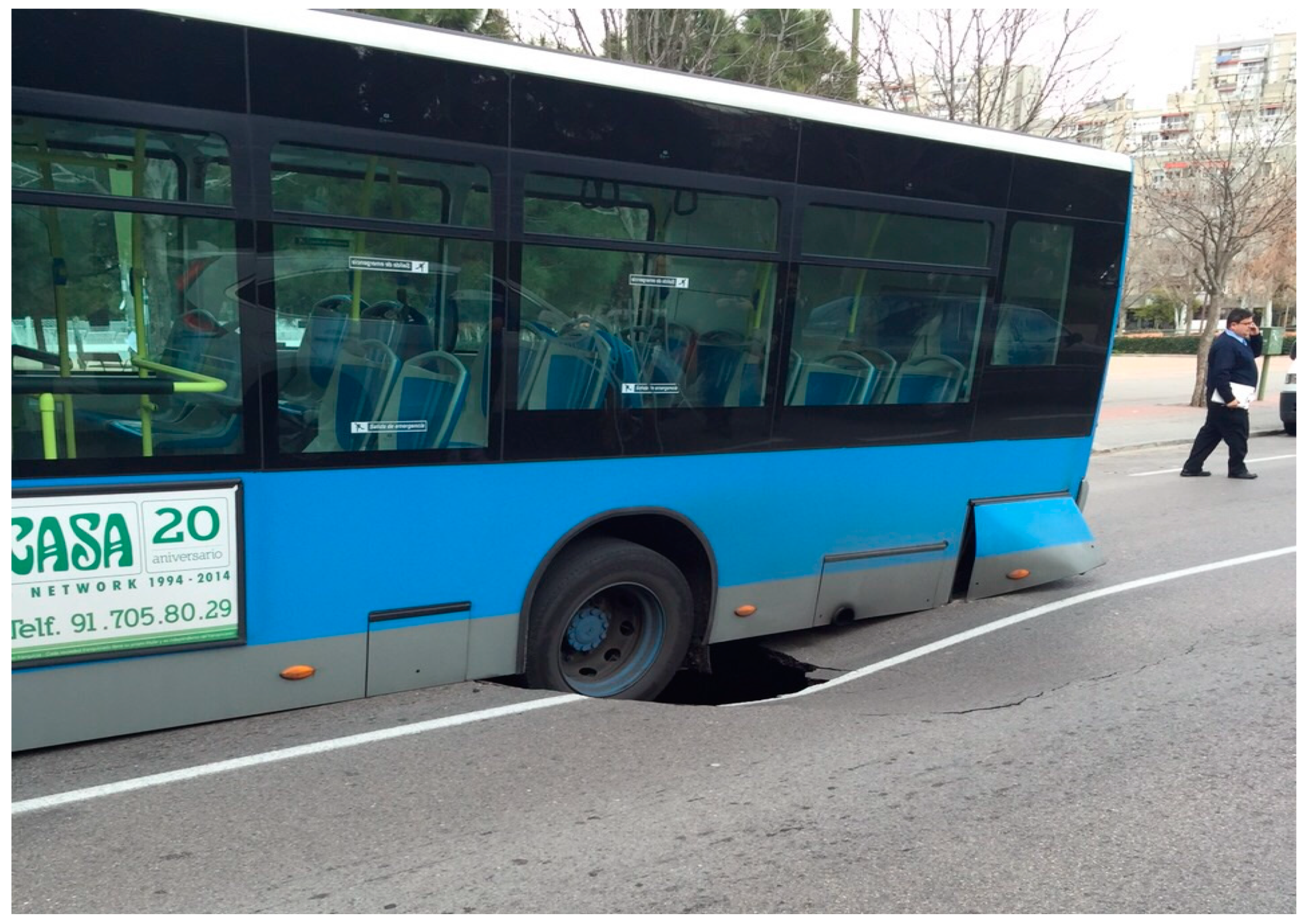
2. Identification of the Risk from the Presence of Anthropic Fills

The term anthropic fill identifies it with human activity. Geotechnics defines it as a terrain contributed by man and has served to differentiate the most superficial horizon of the terrain.
Unlike natural risks and even those induced by anthropic activity, in which vulnerability studies are performed and successfully implemented, the risk due to the presence of built and consolidated areas in anthropic landfills has not yet offered this possibility. This is perhaps due to the complexity of detection in areas built and consolidated decades ago, perhaps because it has a very active dynamic and the many factors that influence its behavior over the years [25].
For classification of an anthropic risk, detailed knowledge of the type of existing land is necessary to correctly define its scope and determine the parameters to be achieved. This is the only way to establish the control systems considered accurate to guarantee achievement of the planned objectives and their compatibility with an already built foundation.
Anthropic fills are highly heterogeneous materials with a hardly foreseen behavior. Their mechanical properties depend on degree of compaction and material type. It is common practice not designing new foundation relying on the mechanical characteristic of these strata.
On the other hand, building structures uses to be rigid compared to the anthropic fill layers, hence if foundations are located within them, structural damages are the likely outcome. They are often manifested as fissures and cracks on the walls and facades.
Damages due to anthropic fills are easily identified on building by the direction, continuity and persistence of the cracks. They often form a coherent pattern that shows the differential settlement undergone by the structure.
Damages on the buildings could many times have been avoided during the design stage. Identification of the anthropic fills by a complete site investigation is probably one of the more efficient method to protect the structures. But many times, the urban environment is so disturbed by housing and previous human activity that lager deposit may pass undetected by the investigations.
During construction, a proper quality control may have also avoided many of the futures damages.
Hence, the risk of the anthropic fill is partially due to unappropriated constriction and design practices, which have often been usual in the pass.
However, the risk is also created by actions that happens during the span life of the structure, which are not related to these initial stages, but to the inevitable evolution of the urban areas. Underground train construction, new services constructions, pavement refurbishment, or leaks on the existing urban facilities can potentially increase the risk for the structure

Geotechnical Characterization of Anthropic Fills

From the geotechnical perspective, uncontrolled anthropic landfills form a ground type of poor geotechnical conditions caused by the decades-long contribution of materials, controlled neither in their spatial arrangement nor in their composition.
They generally have a very heterogeneous composition, under a state of consolidation and high porosity. They are classified as potentially collapsible due to the presence of organic and/or degradable elements. All these factors directly affect the resistance and deformability of this type of materials. Their characteristics tend to suffer strong alterations over time (either due to changes in humidity, dragging, washing or even vibrations), circumstances that classify them as unfit to later support building foundations.
In spite of the inherent difficulty involved in assigning geotechnical parameters for this type of land, basic values can be ventured that show the low geotechnical quality they possess (Table 1) [23,26,27,28,29,30,31].
From analysis of the assigned values, it follows that the risk, due to the presence of uncontrolled anthropic fillers, is always motivated by an anthropic action that is not adjusted to the geotechnical reality. In fact, one should not speak of risk due to anthropic landfills, but of risky infrastructure, depending on the environment where they exist.

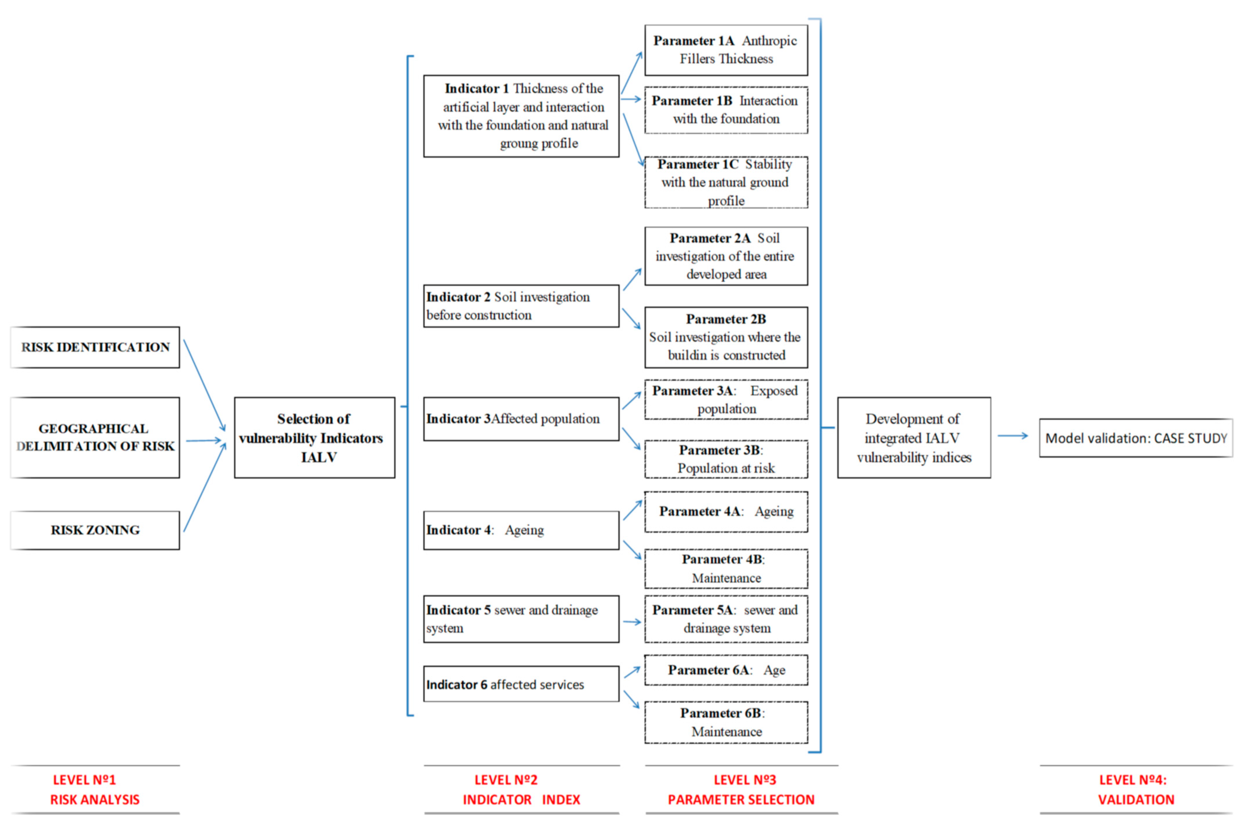
3. Method for Evaluating Vulnerability

Defining human-induced risk factors is an exercise that in itself constitutes a rational approach to the problem. Traditionally, the form of a risk assessment is through the analysis of its factors, closely interlinked; vulnerability is one of the most decisive factors.
As has been reflected in previous epigraphs, the object of this work is creation of a model that faithfully estimates the vulnerability of buildings built on anthropic landfills. The innovation of this research lies in the simplicity of its application and can be extrapolated to any city in the world. For this, the work has been based on the following phases of study (Figure 1).
Vulnerability (V) is expressed either by destroyed property (buildings and services), or affected in an exposed population caused by a certain event, expressed from 0, without damage, to 1, total loss.
Vulnerability ranges from the use of the territory to the structure of buildings and services; it strongly depends on the population’s response to the risk.
In this way, the vulnerability of a structure based on anthropic fills, when this circumstance has not been taken into account, will be enormously greater than that of another structure in which the presence of such risk in the foundation ground has been considered. The number of disasters caused by the presence of anthropic fills will increase over the years in many cities around the world, because as the population grows, the number of people they affect is increasing.

3.1. Methodology Based on Index Indicators

The index-based method is aimed at assessing the vulnerability of buildings built on anthropic fills and allows, in a very simple quantitative way, through a series of indicators, having an effective tool to quantify the vulnerability that will allow architects and engineers to make the best decisions for establishment of structural mitigation measures aimed at minimizing the risk.
The research carried out considers five indicators as parameters, regarding vulnerability factors such as: population; residential, commercial and industrial properties; infrastructure; sanitation; water and electricity supply; public lighting, gas and telephone supply.
For the choice of indicators, those aspects that insurance companies put more interest have been taken into account, as triggers for pathologies of buildings built in anthropic fillings.
The parameters have been agreed with a team of practitioners (civil engineers and architects). They have the same rating range (from 0 to 1), which is precisely the interval by which vulnerability is measured.
The reason for this procedure is due to the fact that the presence or absence of any of these parameters is decisive in the final computation of the vulnerability index.
We must be aware that when trying to define a risk (regardless of its typology and genesis), there is inevitably a certain degree of subjectivity that is impossible to eradicate. Despite this, with this procedure in terms of the choice of parameters and valuation, uncertainty is reduced.

3.2. Definition of the Selected Indicators

Therefore, although this study is offered for the first time, the effectiveness of the Building Vulnerability Index in the Anthropic Landfill area lies in the choice and quantification of the parameters that best define and quantify the scenario of any city in the world.
  • Indicator 1: Thickness of the man-made layer, interaction with the foundation and global stability with regard the natural ground profile.
Thickness of the man-made layer and its interaction with the foundation is the first important factor to be taken into account. Structures with shallow foundations on thick man-made layers are highly vulnerable. However, structures supported on deep foundation to an adequate ground level can easily overcome the risk related to this type of phenomenon. Even so, man-made soils may affected deep foundations. This parameter is in the range from 0 to 1 (Table 2).
An additional factor is the stability of the man-made layer on the natural ground. When the man-made layer is confined by the surrounded natural ground, the vulnerability is low. However, when kinematically possible movement can happen through the ground profile, caused mainly by an unstable contact between anthropic fill and natural soil, then the vulnerability increases.
This unstable contact is mainly conditioned by the original slope of the terrain (angle that the terrain forms with respect to the horizontal). The greater the slope, the greater the vulnerability, especially to natural or artificial processes that modify the conditions of the state of consolidation of anthropic landfills (very intense rains, broken water pipes, vibrations, etc.).
The parameter formula will be:
I1 = (1A + 1B + 1C)/3
Carrying out soil investigation would provide answers to this type of uncertainties and would largely solve the risk by reducing vulnerability, through structural mitigation measures (improper foundation typologies, damaged foundation replacement typologies, fill containment systems, etc.), due to these circumstances, it follows that the performance of soil investigation is a parameter to be taken into account in an objective analysis of the vulnerability study and therefore it has been taken into account in the next parameter to be considered.
  • Indicator 2: Soil investigation before construction
The importance of the soil investigation is vital in the safety of the building and neighborhood, since it specifies the way in which it should be laid and with what loads. It guarantees the resistance of the ground below the foundation to a sufficient depth. It also analyzes and assesses the possible geotechnical conditions, mainly in areas with anthropic landfills, due to its implicit risk for the buildings, roads and services supported on this type of land. Thus, the soil investigation is a necessary parameter. Its valuation in the index will be between 0 if it exists and 1 if it has not been carried out (Table 3).
Following this assessment, for a residential area in which a pre-construction soil investigation is performed in the sector to be developed, the value will be 0. This takes into account the presence and detected thicknesses of anthropic fills along with its zoning. In the same way, in a residential zone where this study has not been carried out, the value will be 1 since no risk has been taken into account or its danger has not been quantified. The residential area will be very vulnerable in the presence of anthropic fills.
With regard to construction, the procedure is the same. In a construction or underpinning project (in the case of being already built on anthropic landfills), when this circumstance has not been taken into account, will be much greater than that of another structure in which the presence of said risk in the field was considered in its foundation.
Once the pathologies have been produced, a soil investigation must be performed on the ground profile supporting the foundation. Anthropic fills, characterized by heterogeneous behavior and composition, in terms of their resistance and deformation, are part of the structure due to their impact on force and should have the same attention in the design and control of the underpinning (if performed), as the rest of the building’s structural elements.
The parameter formula will be:
I2 = (2A + 2B)/2
  • Indicator 3: Affected population
Traditionally, the population is a widely used parameter in determining the social and economic vulnerability of any risk.
At this point, it will be necessary to discern between the exposed population and the population at risk. The exposed population will be (measured in % of the total study area population) that which, despite residing or working in the study area, is not located in the high or medium risk zone but is affected indirectly.
The population at risk (measured in % of the total study area population) resides or works in a medium to high risk zone. The weight of each index is established based on these assumptions and its application to the study area appears in bold (Table 4).
The parameter formula will be:
I3 = (0.25 * 3A + 3B)
  • Indicator 4: Ageing
Structure inevitably wear and tear with time (understood as ageing). Ageing is considered during design stages, and it is initially prevented by a proper quality control during construction. At the end of the construction, investment must not cease. Structures will always require maintenance to ensure adequate performance throughout its span life. In this sense, the insurance companies estimate that the maintenance and replacement of the damaged elements and services of the buildings every 10 years is the most appropriate time interval, from which the progression of wear and deterioration would be linear.
This indicator aims to identify and describe the ageing effects that manifest themselves in a building over time, describing what the control of the building as such should be, proposing an adequate process for maintenance and making a diagnosis of the different deteriorations and damages, which are due to the lack of conservation activities and care of these.
To assess the incidence of the property type on construction vulnerability, it is necessary to take into account the following factors:
  • Building age: this is the date of completing construction. In this section, the following must be considered: In Spain, the Technological Construction Standard has been in existence since 1970 (put in bibliography). This was replaced in March 2006 by the Technical Building Code. Its compliance is mandatory for newly-constructed buildings. In August 2011, technical housing inspection (THI) became mandatory to determine the state of the building’s conservation. This is directed to collective housing more than 50 years old or approaching that age.
  • Maintenance: refers in particular to the state of conservation of water and sanitation pipes directly affecting the geotechnical (tensile-deformation) properties of the landfills supporting the foundation; this is one of the main causes of pathologiesSecond bullet
These milestones are true temporary indicators of the state of conservation and maintenance. The weight of each index is established (see Table 5) depending on this conditioning factor (maintenance).
Following this assessment, a building in which, there is a mandatory building regulation at the time of construction, the value will be 0, having taken into account the presence and detected thicknesses of anthropic landfills, along with the zoning.
Similarly, for a building where there was no mandatory construction regulation, the value will be 1. With regard to maintenance, the procedure is the same. In cities or states where there is no technical inspection regulation for buildings already built, it will be much greater than that of another in which it does exist. The Indicator formula will be:
I4 = (4A * 4B)
  • Indicator 5: proper sewer and drainage system.
No existing sewer systems, poorly maintained drainage infrastructure or no updated to the growing population makes the urban area highly vulnerable. The lack of a proper infrastructure is usually associate with unplanned development areas and impoverish neighborhood. Then they are built on man-made ground their vulnerability is quite high.
As a rule of thumb, the vulnerability of a structure built on an area with man-made deposit is proportional to the lack of a proper sewer and drainage system (Table 6).
  • Indicator 6: affected services
In urban areas, there are services that are provided to the entire population and are considered basic and essential, so the authorities must ensure their availability to the community.
Basic public services are those that correspond to the supply related to the quality of life of the population, such as water supplied, sewers, communications and electricity.This indicator includes buried public or privately-owned facilities that offer a service to society, the interruption of which represents a serious danger or disorder for society in case of failure or breakdown.
In a consolidated urban area, services may be privately owned or run by public bodies. The first are those that depend on service concession companies. The most important are those with high voltage electric power (equal to or greater than 20 kilowatts), telephone, telegraph, gas and water supply (transport or high pressure pipelines).
The second type of services affected are those that depend directly on the municipalities and neighboring communities. The main ones are low-voltage electricity, lighting, water supply, rainwater and/or wastewater collectors, ditches, traffic lights and traffic control, etc.
The most important, because of its impact on the land, consisting of anthropic landfills, is water supply and rainwater and/or wastewater collectors.
The breakage or leaks of water pipes or drains cause serious damage to the building itself and its vicinity (Figure 2), because the variation of the moisture content causes changes on the fill properties.
The effect progress with time and it is usually observed when damages are relevant and economic cost evident.
A leak due to the failure of the pipes from age or lack of maintenance would cause water to enter the landfill (characterized by its high porosity), further impoverishing the poor geotechnical properties of this type of terrain and resistance of the land supporting the buildings, causing the so-called “fine washing” and dragging effect. The structure could not support the stress to overcome cracking and splitting, especially in the façade enclosures. The weight of each index is established (see Table 7 and Table 8) depending on this conditioning aspect (maintenance).
The parameter formula will be:
I6 = [(6A1 * 6B1) + (6A2 * 6B2)]

4. Development of the Integrated Index to Assess Vulnerability

Once the parameters for assessing vulnerability have been selected and defined, the next step will be to develop the Integrated Vulnerability Index for anthropic fill in established urban areas.
With the values assigned to each of the index parameters, a formulation is created based on these in order to obtain an IALV INDEX score. The value of the score ranges from a minimum value of 0 (no damage) and 1 (maximum damage) (Parametric Equation (5)).
IALV INDEX = (I1 + I2 + I3 + I4 + I5 + I6)/6
where:
  • I1 Description of the parameter corresponding to thickness of the artificial layer and interaction with the foundation and natural groung profile = I1 = (1A + 1B + 1C)/3
  • I2 (soil investigation = I2 = (2A + 2B)/2
  • I3 (affected population) = I3 = (0.25 * 3A + 3B)
  • I4 (property) = I4 = (4A * 4B)
  • I5 (sewer and drainage system)
  • I6 (affected services) = (I6 = [(6A1 * 6B1) + (6A2 * 6B2)]
  • N = number of parameters used (equal to 6)
Based on these values, the thresholds which will signal the different levels of vulnerability of the building built on expansive clays are pre-established. Table 9 shows vulnerability scale with the index.

5. Validation of the Model

As noted in previous sections and to validate the proposed model, it has been verified in several Spanish cities and also in a very popular district of the city of Madrid, that by its surface, number of buildings affected and population involved, is truly representative, demonstrating that the model, despite its simplicity due to the number of parameters considered, faithfully estimates the vulnerability of buildings built on anthropic landfills.

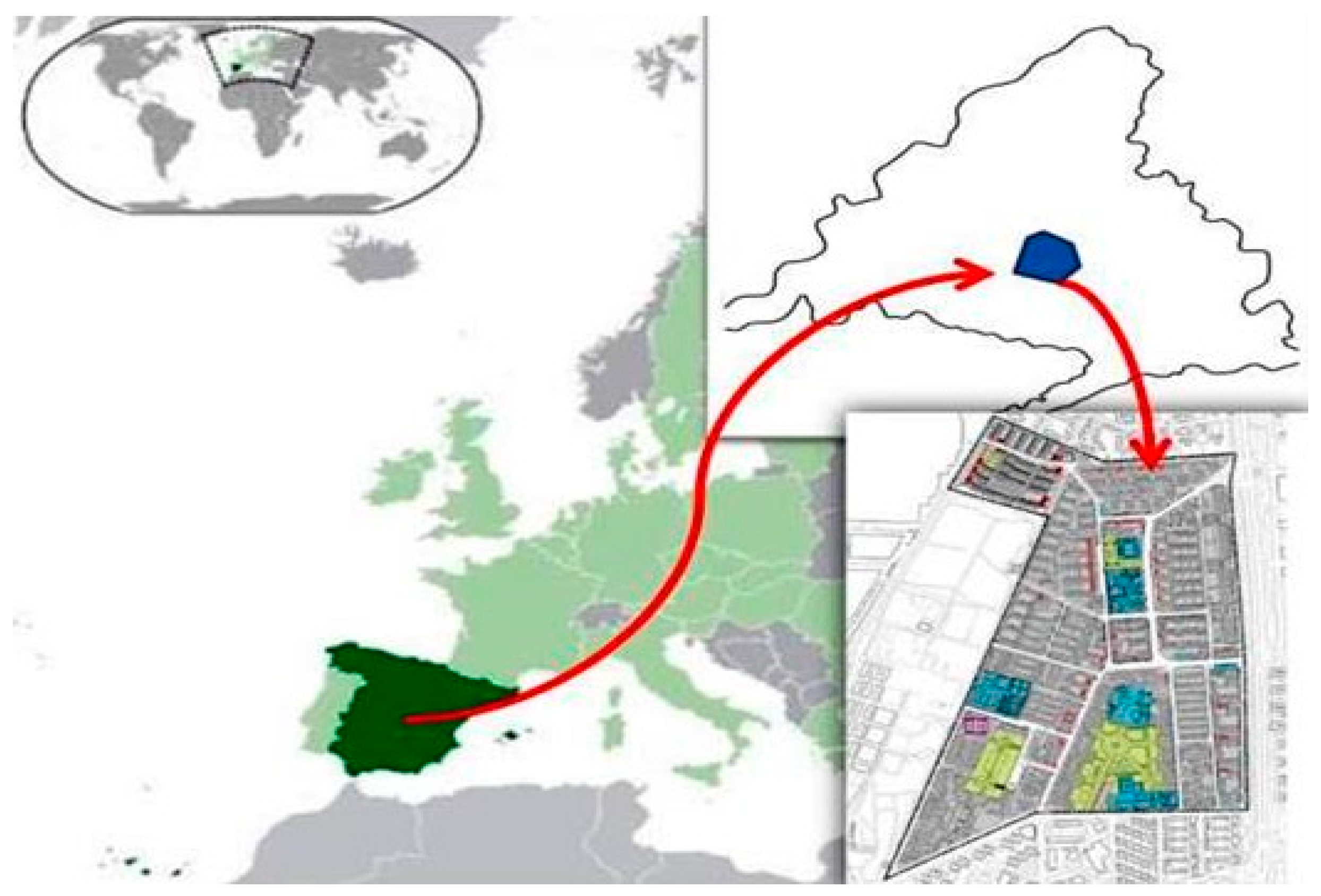
5.1. Geographical Situation and Historical Background

The study area chosen was the neighborhood of “La Ciudad de los Ángeles,” in the Municipal District of Villaverde, located in the southern limit of the municipal district of Madrid (Figure 3).
The area was intensely built during the decades of the 50s and 60s, as a result of the development of a local industry and the need to provide workers with a home near the workplace.
This development was carried out under the Public Housing Policy that characterized the entire country’s urban development during these decades. It has an extension of 59.6 Ha, with an average altitude of 603 m above sea level. It is inhabited by 31,465 people occupying 7996 homes distributed in 441 residential blocks. The characteristics of the study area are broken down in Table 10.
Under the regulations existing at the time, an eminently residential neighborhood was designed, consisting of blocks of exempt structures, from 5 to 8 floors above ground without basements, where the building has a North-South orientation. The neighborhood occupation area was intended for public use such as endowment park land and sport areas. Figure 4 shows the distribution of land uses on the map. The residential area was highlighted in gray; the endowment area in blue and the areas destined for green and sports areas, respectively, in green and pink.
The residential block area is completed with endowment areas located in the central part of the neighborhood with an area of 2.50 Ha, adjacent to another large area (9.0 Ha). The neighborhood’s public park is located there along with various educational centers and the perimeter of which the buildings’ ground floors present the neighborhood’s two most important commercial axes. They gave rise to a typical urban structure of the European rationalism of the moment, with the best Spanish architects participating in its design.
This type of urban planning, together with the type of land on which it sits and the existing foundation types, as described in successive sections, will have decisive repercussions on the integrated vulnerability index.

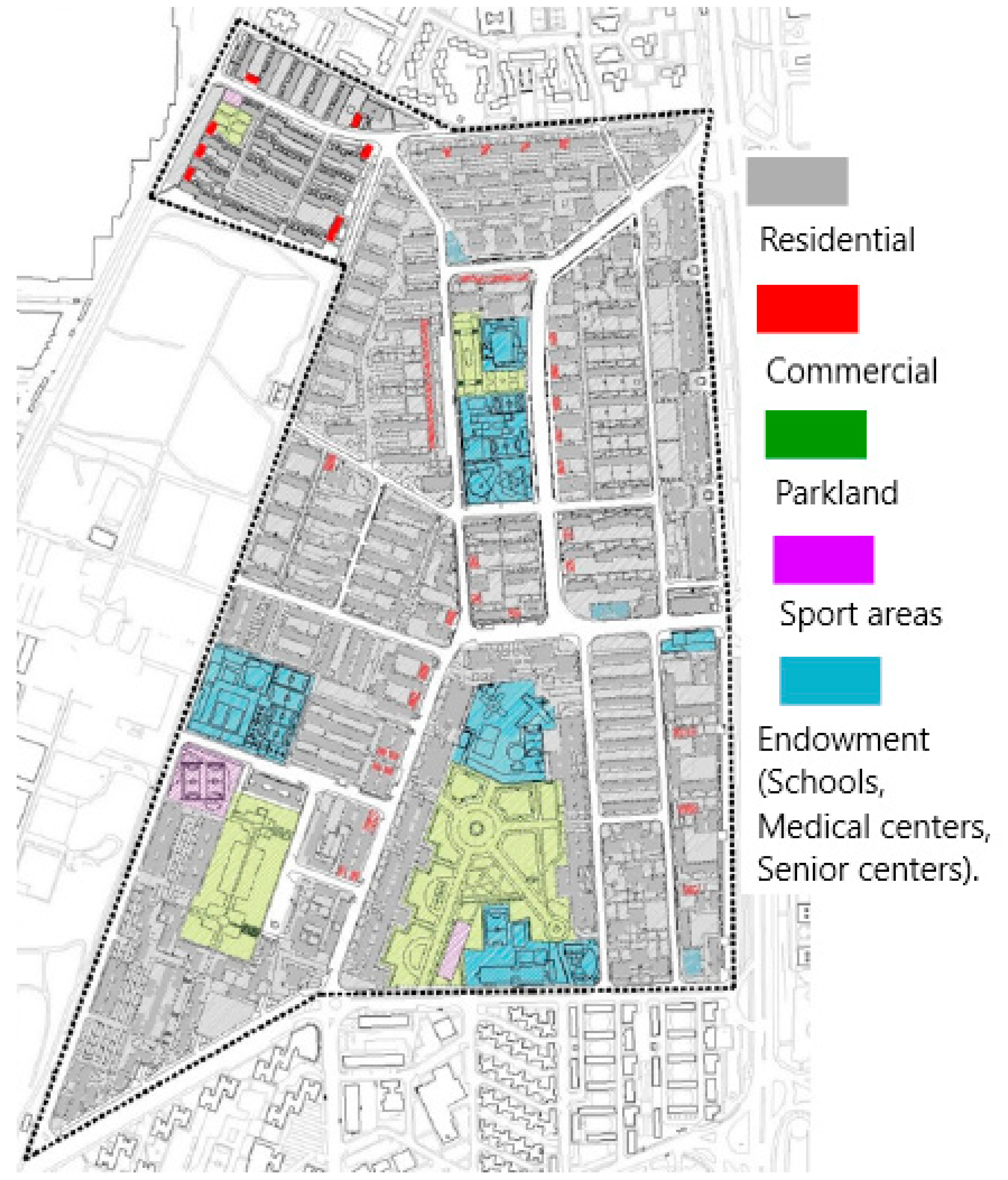
5.1.1. Building Type and Current Situation

As mentioned above, a substantially rectangular open “block” distribution (with wide open spaces) was adopted, in which the housing developments’ developed use maintains very similar structural schemes.
The load distribution within the area occupied by the building maintains a certain symmetry. The greatest loads are usually concentrated in a perimeter strip, supporting pillars of 5 to 8 floors above ground without a basement. The building’s entire weight is supported by a very light direct foundation consisting of footers run under walls and insulated under pillars with a recessed edge of the projected footers that in no case exceeds one meter depth. Perhaps because the construction of a majority of the buildings in the field occurs prior to the approval of any technical regulations, the economy of the building is essentially addressed.
This conditioning aspect, already deficient in itself, is aggravated by relying on a predominantly clay anthropic filler of very plastic nature, characterized by consistency classified as soft to medium.
Under these circumstances, 35% of buildings are noted as having a structural problem due to inadequate foundation (Figure 5), the design and dimensioning is not consistent with the land’s geotechnical characteristics. It is very common for the foundation to be supported directly on anthropic fillers of low consolidation status. Despite having achieved a balance between the foundation and the ground over the years, this has been truncated by the poor state of the water pipes (mainly sanitation and rainwater collection), which breaks the tension balance. The foundation, already deficient in itself, has not adapted to the new stress field, triggering the pathologies due in differential bases not assimilated by the structure.

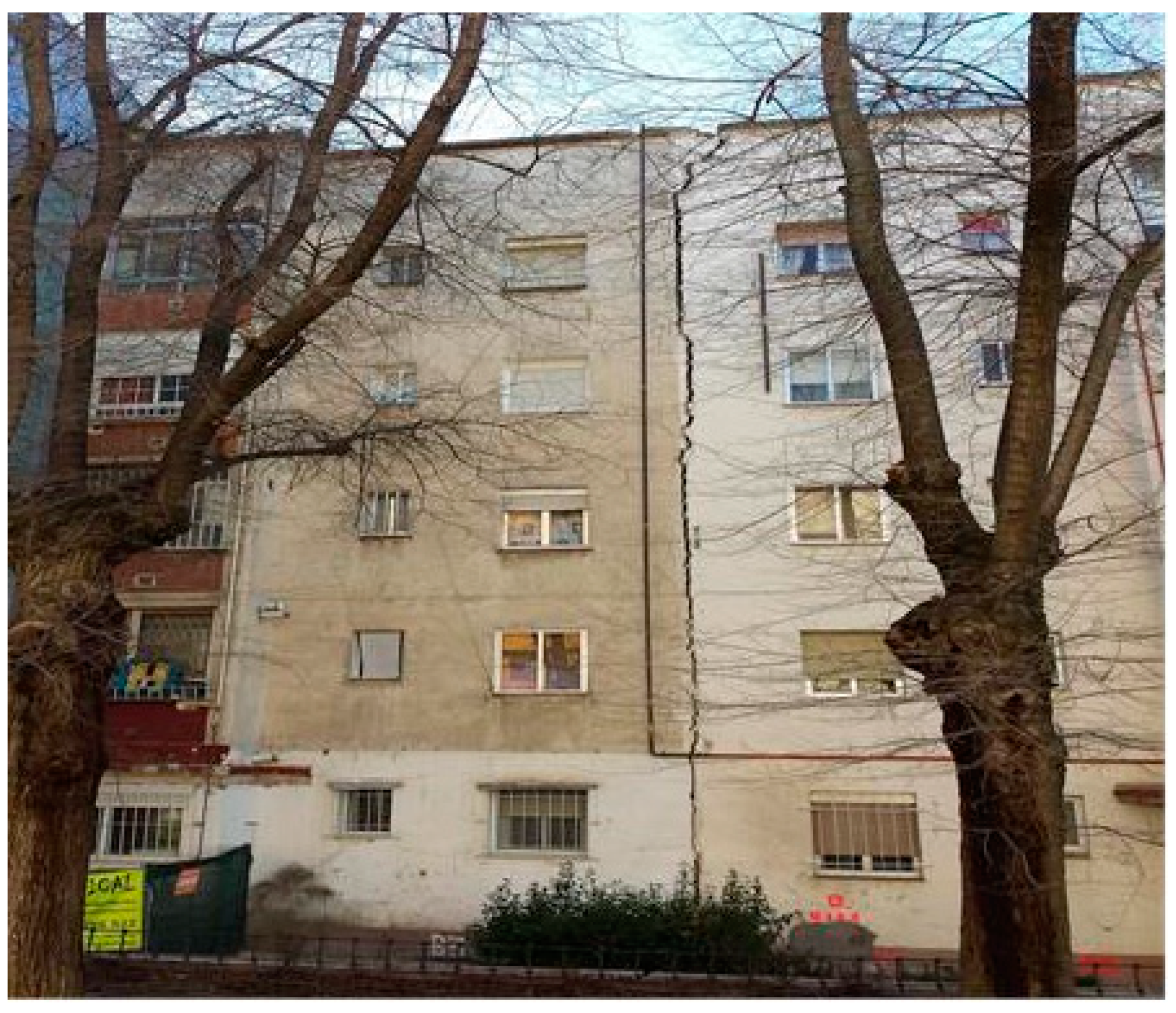
5.1.2. Type of Pathologies in Buildings

On most occasions and, due to the prolonged useful life of these constructions (decade of the 1960s), the pathologies are due to the conditions of the land on which they are based.
The supporting ground undergoes changes over time, mainly due to anthropic actions. This circumstance involves new stress states, with very different deformations from those that prevailed during its construction and for which the original foundation was not designed. Consequently, the causes of these pathologies are motivated primarily by the presence of differential settling, which sometimes compromises building preservation. Such settling is usually caused by three factors:
  • Variations in the distribution of the permanently applied loads, which are mainly caused by activity related to extensions, refurbishments and modifications carried out on the structure of the building.
  • Changes in the mechanical properties of the soils on which the foundations rest, which results in a new distribution of stresses. This new stress field can be caused by:
    • Leaks or breaks in water pipes that affect the foundation soil.
    • Physical and chemical deterioration of the foundations.
  • A combination of the two causes.
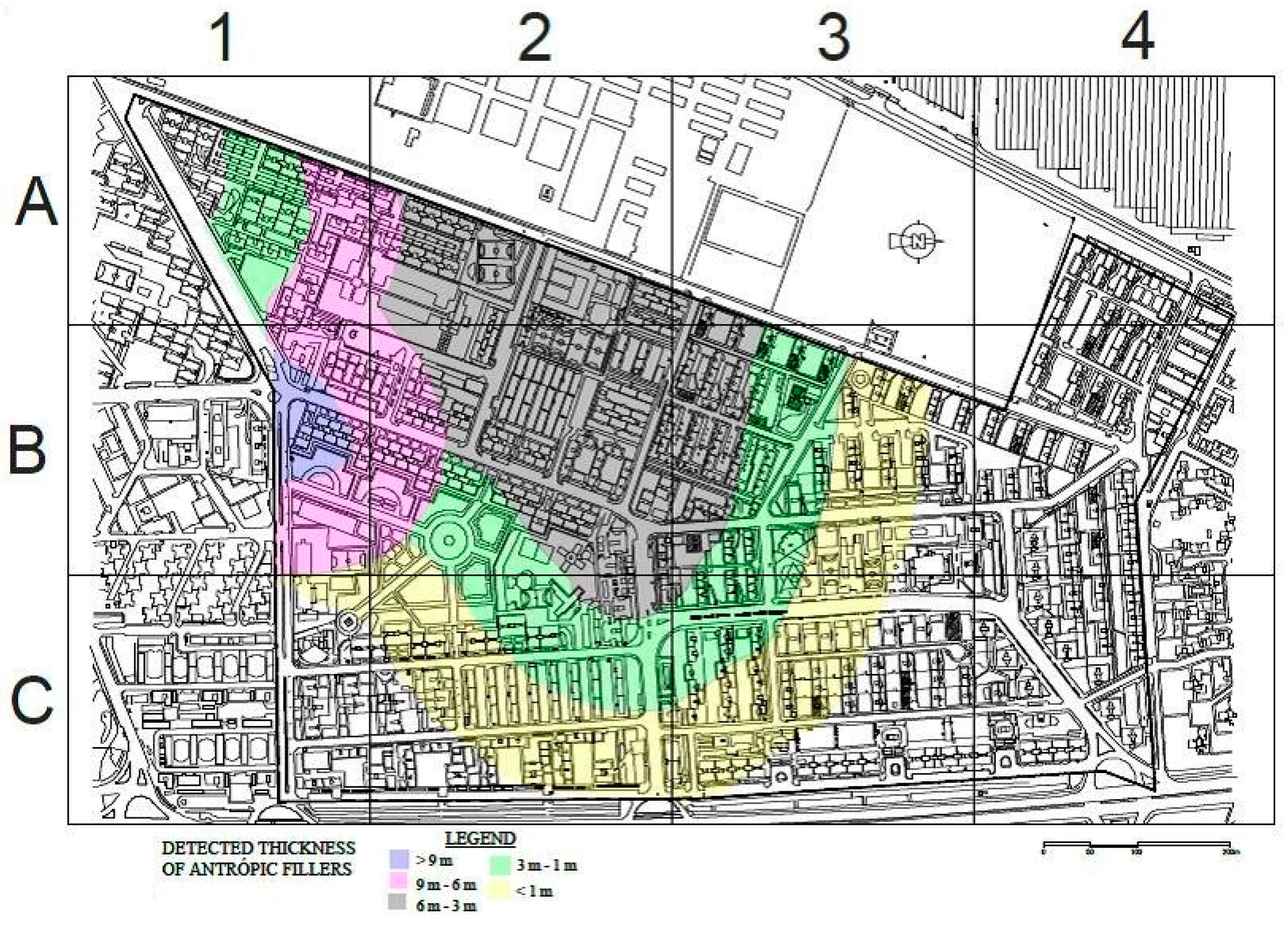
However, in any of the factors listed above, the action to be carried out must be aimed at making the soil-structure interaction able to adapt to the new tension scenario. Such adaptation can be achieved by underpinning the foundation.

5.2. Risk Zoning

Once the risk has been identified, its zoning constitutes a fundamental step for its study; therefore, in the early stages of the investigation, zoning has been carried out in terms of spatial distribution and thickness of anthropic fillings.
This zoning was carried out by reviewing the evidence of 36 geotechnical boreholes, with the performance of standard penetration tests (SPT) and pressure gauge tests at regular depths, collected in this sector, and their comparison with aerial photographs from 1950. Its purpose was to delimit its geographical distribution (Figure 6). This work made it possible to define that the contact between the anthropic fills and the natural terrain is horizontal, it also allowed zoning based on the thickness of the fills detected and limiting the size of the risk due to the presence of anthropic fills, the analysis of which yields data of evident interest. Next, the aerial anthropic fill areas were classified into 3 categories ranging from low, medium to high, according to the thickness of the fillings detected, as described in Table 11.

5.3. Integrated Index Development to Evaluate Vulnerability

Once the parameters for estimating vulnerability have been selected and defined, the next step will be developing the Integrated Anthropic Landfill Vulnerability Index (IALV), in consolidated urban areas.
A formulation is created based on the ratings given to each of the index parameters with the purpose of giving an IALV score. The score value ranges from a minimum value of 0 (no damage) to 1 (maximum damage).
Based on these values, the thresholds are set that will mark the different degrees of vulnerability of construction with foundations in anthropic landfills, as detailed in Table 9. Three cases were adopted for calculating the index, high, medium and low risk respectively. Subsequently, the results obtained in estimating the index were analyzed.
  • Case 1:
Buildings in risk areas due to the presence of anthropic fillings with investigation of supporting soils and regular maintenance of buildings affected services. Characteristics in Table 12.
Create a formulation based on the ratings given to each of the index parameters, with the purpose of giving an IALV score:
IALV = (P1 + P2 + P3 + P4 + P5 + P6)/6
IALV = 0.17
  • Case 2:
Buildings in a high-risk area due to the presence of man-made landfills without study of the ground for the shoring, unstable contact between the man-made fill (Slope between 16 to 35°) and the natural soil with maintenance of the building and the affected services in buildings. Characteristics in Table 13.
Create a formulation based on the ratings given to each of the index parameters, with the purpose of giving an IALV score:
IALV = (P1 + P2 + P3 + P4 + P5 + P6)/6
IALV = 0.27
  • Case 3:
Buildings in a high-risk area due to the presence of man-made landfills without study of the ground for the shoring, unstable contact between the man-made fill (Slope between 16 to 35°) and the natural soil without maintenance of the building and the affected services in buildings; characteristics in Table 14.
Create a formulation based on the ratings given to each of the index parameters, with the purpose of giving an IALV score:
IALV = (P1 + P2 + P3 + P4 + P5 + P6)/6
IALV = 0.86

6. Analysis of Results and Discussion

From the analysis of the results obtained, it follows.
  • In case 1, it was carried out in the assumption that the buildings, despite being very old and in a high-risk area due to the presence of anthropic landfills, have an IALV vulnerability index is less than 0.17 (corresponding to low risk).
  • On the other hand, case No. 3 was carried out in the assumption that the buildings are still located in a high-risk area due to being very old and having the presence of anthropic landfills. When analyzing the results obtained, have an IALV vulnerability by unit order (corresponding to high risk).
  • Finally, case No. 2 was carried out in the assumption that the buildings are very old and still located in a high-risk area due to the presence of anthropic landfills and buildings. When analyzing the results obtained, have an IALV vulnerability by unit order (corresponding to medium risk).
  • Those indices whose result has been close to unity, the buildings had to be demolished. In contrast, when the index was close to zero, the buildings were well preserved or with little damage. Upon closer study, it was discovered that they had been regularly maintained and located in low to moderate risk areas.
  • When the vulnerability index has had an average value, it has been verified that the buildings had damage to facades and structures even though the integrity of the building was not compromised and that they were subsequently undermined.
For all cases, the assumptions are the same:
  • All the studied buildings are the same age, with similar structural characteristics in terms of the typology of the building. At the time of construction of this neighborhood (mid-twentieth century), it was not mandatory or usual to carry out a site investigation for housing or for each building. Sadly, the main rewarded aspect was the speed and the low-cost in the construction.
  • The foundations were direct (Beams under walls and isolated footing under columns). They we founded on the anthropic fill, although not all have the same risk, since the fill thickness was different.
  • The buildings have been monitored for four years. Numerous visits have been taken to the study area when any of the following phenomenon occurs:
    • Abundant rains
    • Water supplied ductus breakdowns.
    • Site investigations and damages assessment for future underpinning protects.
    • Routine building inspection
    • Building refurbishment projects
Based on these assumptions, it was to be expected that the vulnerability indices would be similar or at least all the estimated indices would be in the same range. However, this is not the case. What is more, it can be seen that the three situations envisaged still exist.
When analysing the three cases of calculation, it is verified that the periodic and regular maintenance of the buildings is essential, not only of the structure of the building itself, but also the main infrastructure. As a leak of these, directly affects the tenso-deformational behaviour of the anthropic fill and consequently to the foundation that rests on it.
It has been verified that every time a water leak was observed, pathology occurred in the building itself or in areas surrounding it, in a short period of time after it.
Sometimes, when there was damage to the buildings due to settlements, the underpinning work was carried out by low-qualified companies, which face this work in an empirical way without any site investigation neither a construction scheme. In these cases, the effectiveness of the work has proved to be rather limited.
However, those sites whose reinforcement works have been conducted in rational way, after a site investigation and a scheme, has proved to be the most effective measure. Moreover, when this work was carried out, the surrounding buildings have also reinforced the foundation as a preventive measure.

7. Limitations of the Integrated Index to Evaluate Vulnerability (IALV) on Anthropic Fillings in Urban Areas

Due to the lack of research regarding the vulnerability study, given the risk of the presence of anthropic landfills in buildings constructed in already consolidated areas, it has not been possible to compare the IALV model with other studies. This circumstance makes this integrated index an eminently practical, totally unpublished research topic.
Detailed knowledge of a series of awards has been necessary for developing the index:
(a)
Know if there is a regulation regarding the geotechnical investigation of the land for construction and if these regulations are mandatory or merely best practice recommendations. It is also essential to know the time interval in which it is in force.
(b)
Likewise, know if there is a regulation regarding the conservation and maintenance of buildings and if compliance with these regulations is mandatory. It is also essential to know the time interval in which it is in force.
(c)
Not knowing these regulations, or if there are countries where they do not exist, can make it difficult to assess the index. The information provided by the soil investigation or the maintenance of the facilities of each building would be random when only each community of residents, owners, or company providing services performs these tasks.

8. Conclusions

This paper has objectively quantified the vulnerability of structures in areas developed on anthropic fills, while creating a methodology, hitherto unpublished, of its estimate. This methodology can be extrapolated to any part of the world after including the peculiarities of each location.
The outcome show that the index is valid for estimating the vulnerability of construction. It can be applied directly in decision-making by the different administrations (local, regional or national), engineers and architects, in charge of managing areas already developed.
The need of knowledge is one of the main conclusions that emerge from this research. Site investigation should routinely be carried out for design new structures.
Another of the conclusions that also emerge from the study is the benefit of a periodic maintenance of the building itself and the infrastructure around.
Specifically, it includes all water suppled mains and sewer duct own by local administration or statutory companies.
The effectiveness of the proposed method is due precisely to its simplicity. Implementing vulnerability indices with more parameters would, in authors opinion, involve unnecessary complexity in order to reach the same conclusions.
This index has been successfully tested in three different areas of different locations in Spanish cities (Madrid, Zaragoza, and Aranjuez). During the four years that the research has lasted, it has been reliably ratified, as in those buildings where no maintenance has been carried out, pathologies have occurred that have sometimes led to the demolition of the building.
It has also been proven that routine site investigations and period inspection dramatically reduce the damage on the structures.
Finally, it is observed that the effectiveness of the index lies in the choice and quantification of the indicators or parameters that best define and quantify the scenario of any city in the world. All indicators were initially agreed upon by practitioners. This work was fundamental, in order to reduce the number of indicators and make them truly representative.
As a future line of research, it has begun to check these parameters to prepare a vulnerability index of cities settled on expansive clay.

Author Contributions

Conceptualization, F.E.S.; methodology, F.E.S.; validation, F.E.S., F.P.I. and M.B.A.; formal analysis, F.E.S.; investigation, F.E.S. and M.B.A.; data curation, M.B.A.; writing—original draft preparation, F.E.S. and M.B.A.; writing—review and editing, F.E.S. All authors have read and agreed to the published version of the manuscript.

Funding

This research is one of the results of the research contract for the title: “Scientific-technical advice on natural, mixed and induced risks for national and international projects” between the company GEOINTEC and the Polytechnic University of Madrid, of which Félix Escolano is the Principal investigator.

Institutional Review Board Statement

Not applicable.

Informed Consent Statement

Not applicable.

Data Availability Statement

Not applicable.

Acknowledgments

The authors of the article appreciate the support given in time and resources by GEOINTEC Company and the Geology and Geotechnical Department of UPM—ETS Civil Engineering.

Conflicts of Interest

The authors declare no conflict of interest.

Abbreviations

IALV
Integrated Evaluation Model of Construction Vulnerability in Anthropic Fill Areas.
GIS
Geographic Information System.
SPT
Standard Penetration Tests.

References

  1. Ciotoli, G.; Stigliano, F.; Mancini, M.; Marconi, F.; Moscatelli, M.; Cavinato, G.P. Geostatistical interpolators for the estimation of the geometry of anthropogenic deposits in Rome (Italy) and the physical-mechanical characterization related to implications in the evaluation of geographic risk. Environ. Earth Sci. 2015, 74, 2635–2658. [Google Scholar] [CrossRef]
  2. Demographia World Urban Areas. Built-Up Urban Areas or World Agglomerations. 10th Annual Edition, Wendell Cox Consultancy, Belleville. Available online: http://demographia.com/db-worldua.pdf. (accessed on 30 October 2014).
  3. Burghardt, W. Soils in urban and industrial environments. Z. Für Pflanz. Und Bodenkd. 1994, 157, 205–214. [Google Scholar] [CrossRef]
  4. Lehmann, A.; Stahr, K. Nature and significance of anthropogenic urban soils. J. Soils Sediments 2007, 7, 247–260. [Google Scholar] [CrossRef]
  5. Cearreta, A. Geological definition of the Anthropocene by the Anthropocene Working Group (AWG). Enseñanza De Las Cienc. De La Tierra 2015, 23, 263–271. [Google Scholar]
  6. Haff, P.K. Technology as a geological phenomenon: Implications for human well-being. In A Stratigraphical Basis for the An-Thropocene; Waters, C.N., Zalasiewicz, J., Williams, M., Ellis, M., Snelling, A.M., Eds.; Geological Society of London, Special Pub-lication: London, UK, 2014; pp. 301–309. [Google Scholar]
  7. Waters, C.N.; Zalasiewicz, J.A.; Williams, M.; Ellis, M.A.; Snelling, A.M. A stratigraphical basis for the Anthropocene? Geol. Soc. Lond. Spéc. Publ. 2014, 395, 1–21. [Google Scholar] [CrossRef] [Green Version]
  8. Artaxo, P. Uma nova era geológica em nosso planeta: O Antropoceno? Rev. USP 2014, 13–24. [Google Scholar] [CrossRef] [Green Version]
  9. Cigna, F.; Jordan, H.; Bateson, L.; McCormack, H.; Roberts, C. Natural and Anthropogenic Geohazards in Greater London Observed from Geological and ERS-1/2 and ENVISAT Persistent Scatterers Ground Motion Data: Results from the EC FP7-SPACE PanGeo Project. Pure Appl. Geophys. PAGEOPH 2014, 172, 2965–2995. [Google Scholar] [CrossRef] [Green Version]
  10. De Vries, J. European Urbanization; Routledge: London, UK, 2006; pp. 1500–1800. [Google Scholar]
  11. Alfageme, G.B. La evolución del poblamiento en la dinámica rural-urbano. Norba. Rev. De Geogr. 2006, 11, 107–127. [Google Scholar]
  12. Olano, E.U. Evoluciones, tensiones y complementariedad entre lo rural y lo urbano en Francia. Geographicalia 2010, 58, 141–153. [Google Scholar]
  13. Yaghmaei-Sabegh, S.; Rupakhety, R. A new method of seismic site classification using HVSR curves: A case study of the 12 November 2017 Mw 7.3 Ezgeleh earthquake in Iran. Eng. Geol. 2020, 270, 105574. [Google Scholar] [CrossRef]
  14. Ayala-Carcedo, F.J.; Cina Cantos, J.L. Riesgos Naturales; Ariel Ciencia: Madrid, Spain, 2002. [Google Scholar]
  15. Lario, J.; Bardaji, T. Introducción a los Riesgos Geológicos; Editorial UNED: Madrid, Spain, 2017. [Google Scholar]
  16. Carcedo, F.J.; Ayala, M.; Elizaga., E. Economic and Social Impacts of the Geological Hazards in Spain: With English Summary; IGME: Madrid, Spain, 1987. [Google Scholar]
  17. Ciotoli, G.; Stigliano, F.; Marconi, F.; Moscatelli, M.; Mancini, M.; Cavinato, G. Mapping the Anthropic Backfill of the Historical Center of Rome (Italy) by Using Intrinsic Random Functions of Order k (IRF-k). Int. Conf. Comput. Sci. Its Appl. 2011, 6782, 92–102. [Google Scholar] [CrossRef]
  18. Floris, M.; Bozzano, F.; Strappaveccia, C.; Baiocchi, V.; Prestininzi, A. Qualitative and quantitative evaluation of the influence of anthropic pressure on subsidence in a sedimentary basin near Rome. Environ. Earth Sci. 2014, 72, 4223–4236. [Google Scholar] [CrossRef]
  19. Bozzano, F.; Andreucci, A.; Gaeta, M.; Salucci, R. A geological model of the buried Tiber River valley beneath the historical centre of Rome. Bull. Int. Assoc. Eng. Geol. 2000, 59, 1–21. [Google Scholar] [CrossRef]
  20. Martín-Antón, M.; Negro, V.; del Campo, J.M.; López-Gutiérrez, J.S.; Esteban, M.D. Review of coastal land reclamation situ-ation in the world. J. Coast. Res. 2016, 75, 667–671. [Google Scholar] [CrossRef]
  21. Donadio, C.; Vigliotti, M.; Valente, R.; Stanislao, C.; Ivaldi, R. Los cambios de costa antrópicos frente a los naturales a lo largo de la costa norte de Campania, Italia. J. Coast. Conserv. 2018, 22, 939–955. [Google Scholar] [CrossRef]
  22. Rodríguez-Castillo, R. Consecuencias sociales de un desastre inducido, subsidencia. Boletín De La Soc. Geológica Mex. 2006, 58, 265–269. [Google Scholar] [CrossRef]
  23. Escolano Sánchez, F.; Mazariegos de la Serna, A.; Sánchez Lavín, J.R. Underpinning of shallow foundations by expansive polyurethane resin injections. Case study: Cardinal Diego de Espinosa Palace in Segovia (Spain). Rev. De La Construcción 2017, 16, 420–430. [Google Scholar] [CrossRef] [Green Version]
  24. Evangelista, L.; de Silva, F.; d’Onofrio, A.; Di Fiore, V.; Silvestri, F.; di Santolo, A.S. Application of ERT and GPR geophysical testing to the subsoil characterization of cultural heritage sites in Napoli (Italy). Measurement 2017, 104, 326–335. [Google Scholar] [CrossRef]
  25. Escolano Sánchez, F.; Serrano, R. Hazards Caused by Uncontrolled Vegetation and Inadequate Maintenance Practice in Earth Dams. Tecnol. Y Cienc. Del Agua 2015, 6, 137–164. [Google Scholar]
  26. Lavín, J.R.S.; Sánchez, F.E.; De La Serna, A.M. Chemical Injections Realized with Null Pressure for Underpinning the Foundation of an 18th Century Building Located in the Historical City of Cuenca (Spain). Appl. Sci. 2018, 8, 1117. [Google Scholar] [CrossRef] [Green Version]
  27. Escolano-Sánchez, F.; Bueno-Aguado, M.; Fernández-Ordóñez, D. The Finite Elements Method (FEM) versus traditional Methods (TM), in the estimation of settlement and modulus of soil reaction for foundation slabs design on soils with natural or man-made cavities. Inf. De La Construcción 2015, 67, e069. [Google Scholar] [CrossRef] [Green Version]
  28. SPICC, S. Sobre los sistemas y parámetros geotécnicos de diseño en la ampliación del metro de Madrid. Rev. De Obras Públicas 2003, 3, 49–67. [Google Scholar]
  29. Oteo, C.; Rodriguez Ortiz, J.M.; Melis, M. Criterios de diseño de pantallas continuas en la ampliación del Metro de Madrid. Ing. Civ. 2003, 129, 5–15. [Google Scholar]
  30. Ortíz, R. Propiedades Geotécnicas de los Suelos de Madrid; Revista de Obras Públicas: Madrid, Spain, 2000. [Google Scholar]
  31. Eclaircy-Caudron, S.; Dias, D.; Kastner, R. Assessment of Soil Parameters Met during a Tunnel Excavation: Use of Inverse Analysis on In Situ Measurements—Case of Bois de Peu (France). Adv. Meas. Model. Soil Behav. 2007, 1–10. [Google Scholar] [CrossRef]
Figure 1. Research methodology diagram.
Sustainability 13 08575 g001
Figure 2. Sinking of a vial constructed of man-made due to sewer collapse.
Sustainability 13 08575 g002
Figure 3. Geographical location of the study area.
Sustainability 13 08575 g003
Figure 4. Urban planning: distribution of the building and equipment of the study area.
Sustainability 13 08575 g004
Figure 5. Overview of the type of pathologies observed.
Sustainability 13 08575 g005
Figure 6. Anthropic fill zoning plan.
Sustainability 13 08575 g006
Table 1. Geotechnical parameters.
Geotechnical ParameterApparent Specific Weight
(kN/m3)
Cohesion
(KPa)
Internal Friction AngleDeformation Module
MPa
Horizontal Ballast Coefficient
(t/m3)
Proposed value180288–10800–2000
Table 2. Description of the parameter corresponding to Thickness of the artificial layer and interaction with the foundation and natural groung profile.
Vulnerability IndicatorTitle
Parameters
DescriptionAssessment
Indicator 1Parameter 1A
Anthropic Fillers Thickness
Artificial layer thickness less than 1.0 m0
Artificial layer thickness between 1.0 to 3.0 m0.5
Artificial layer thickness greater than 3.0 m1
Parameter 1B
Interaction with the foundation
The foundation crosses the artificial layer is supported by natural ground0
The foundation does not cross the artificial layer, it is supported by anthropic fill1
Parameter 1C
Stability with the natural ground profile
Slope less than 15°0
Slope between 15 to 25°0.25
Slope between 16 to 35°0.75
Slope greater than 35°1
Table 3. Description of the parameter corresponding to soil investigation and assessment.
Vulnerability
Indicator
Title
Geotechnical Study
DescriptionAssessment
Indicator 2Parameter 2A
Soil investigation of the entire developed area
There is a compressive soil investigation0
There is not a compressive soil investigation1
Parameter 2B
Soil investigation on the plot where the buildin is constructed
There is a compressive soil investigation0
There is not a compressive soil investigation1
Table 4. Description of the parameter corresponding to the population and valuation.
Vulnerability IndicatorTitle
Population
DescriptionAssessment
Parameter 3Parameter 3A
Exposed population
Less than 10% of the total study area population0
Between 10 and 30% of the total study area population0.25
Between 30 and 60% of the total study area population0.5
Greater than 60% of the study area population1
Parameter 3B
Population at risk
Less than 10% of the total study area population0
Between 10 and 30% of the total study area population0.25
Between 30 and 60% of the total study area population0.5
Between 60 and 80% of the total study area population0.75
More than 80% of the total study area population1
Table 5. Description of the parameter corresponding to the population and valuation.
Vulnerability IndicatorTitle
Property
DescriptionAssessment
Indicator 4Parameter 4A
Ageing
Buildings built after 20100
Buildings built between 1990 and 20100.25
Buildings built between 1970 and 19900.5
Buildings built between 1950 and 19700.75
Buildings built before 19501
Parameter 4B
Maintenance
Buildings with maintenance less than 10 years0
Buildings with maintenance between 10 and 20 years0.25
Buildings with maintenance between 20 and 30 years0.5
Buildings with sporadic maintenance0.75
Buildings without maintenance1
Table 6. Description of the parameter corresponding to the sewer and drainage system.
Vulnerability IndicatorDescriptionAssessment
Indicator 5Proper sewer and drainage system0
Lack of proper sewer and drainage system1
Table 7. Description of the parameter corresponding to the affected services and assessment.
Vulnerability IndicatorAffected Services Dependent on Concession Companies PipelinesDescriptionAssessment
Indicator 6AParameter 6A1
Ageing of pipes
Built after 20100
Built between 1990 and 20100.25
Built between 1970 and 19900.5
Built between 1950 and 19700.75
Built before 19501
Parameter 6B1
Pipeline maintenance
With maintenance less than 10 years0
With maintenance between 10 and 20 years0.25
With maintenance between 20 and 30 years0.5
With sporadic maintenance0.75
Without maintenance1
Table 8. Description of the parameter corresponding to the affected services and assessment.
Vulnerability IndicatorServices Affected: Water Supply and Collectors Dependent on Municipalities and Communities of OwnersDescriptionAssessment
Indicator 6BParameter 6A2
Ageing of pipes
Built after 20100
Built between 1990 and 20100.25
Built between 1970 and 19900.5
Built between 1950 and 19700.75
Built before 19501
Parameter 6B2
Pipeline maintenance
With maintenance less than 10 years0
With maintenance between 10 and 20 years0.25
With maintenance between 20 and 30 years0.5
With sporadic maintenance0.75
Without maintenance1
Table 9. Vulnerability scale with the index.
Values of the IndexVulnerability LevelDamage to the Building
Index with values between 0.0 and 0.24LowThe building has no structural damage
Index with values between 0.25 and 0.50MediumThe building has structural damage.
It had to be stressed
Index with values between 0.51 and 1.0HighThe building has had to be demolished
Table 10. Characteristics of the study area.
CharacteristicsDescription
Area 59.6 ha
PropertyResidential7996 housing units
441 housing blocks
Commercial569 shops located on the ground floor of buildings
IndustrialNone
Building age 1950s and 1960s
Building type Housing blocks 5–8 storeys above ground level without basements
Existing foundations Shallow foundations:
Isolated footing under columns and continuous footing under walls
Damage in buildings Different settling rates in foundations
Damaged buildings (%) 35% of the buildings (154 buildings)
Financial quantification of the damage (M €) 15.6
PopulationTotal population31,465
Exposed population20,453
Population at risk11,012
Table 11. Thickness of fillers detected.
CategoryThickness Detected
NullThickness less than 1.0 m
LowThickness between 1.0 m and 3.0 m
AverageThickness between 3 m and 5 m
HighThickness greater than 5.0 m
Table 12. Characteristics of case 1.
Vulnerability Indicator (I)Parameter
Title (P)
DescriptionAssessment
Indicator I1Anthropic Fillers ThicknessArtificial layer thickness between 1.0 to 3.0 m0.5
Interaction with the foundationThe foundation crosses the artificial layer is supported by natural ground0
Stability with the natural ground profileSlope less than 15°0
Indicator I2
(Soil investigation)
Soil investigationNeighborhood Soil investigation0
Soil investigation of building underpinning0
Indicator I3
(Population)
Affected populationGreater than 60% of the study area population0.75
Population at riskBetween 30 and 60% of the total study area population0.5
Indicator I4
(Property)
AgeBuildings built between 1950 and 19700.75
MaintenanceBuildings with maintenance less than 10 years0
Indicator I5
proper sewer and drainage system
proper sewer and drainage systemProper sewer and drainage system0
Indicator I6
(Services affected)
Concessionary company employeesBuilt between 1970 and 19900.5
With maintenance less than 10 years0
Town hall employees and owners’ communitiesBuilt between 1950 and 19700.75
With maintenance less than 10 years0
Table 13. Characteristics of case 2.
Vulnerability Indicator (I)Parameter
Title (P)
DescriptionAssessment
Indicator I1Anthropic Fillers ThicknessArtificial layer thickness greater than 3.0 m1
Interaction with the foundationThe foundation does not cross the artificial layer, it is supported by anthropic fill1
Stability with the natural ground profileSlope between 16 to 35°0.75
Indicator I2
(Soil investigation)
Soil investigationNeighborhood Soil investigation1
Soil investigation of building underpinning1
Indicator I3
(Population)
Affected populationGreater than 60% of the study area population0.75
Population at riskBetween 30 and 60% of the total study area population0.5
Indicator I4
(Property)
AgeBuildings built between 1950 and 19700.75
MaintenanceBuildings with maintenance less than 10 years0
Indicator I5
proper sewer and drainage system
proper sewer and drainage systemProper sewer and drainage system0
Indicator I6
(Services affected)
Concessionary company employeesBuilt between 1970 and 19900.5
With maintenance less than 10 years0
Town hall employees and owners’ communitiesBuilt between 1950 and 19700.75
With maintenance less than 10 years0
Table 14. Characteristics of case 3.
Vulnerability Indicator (I)Parameter
Title (P)
DescriptionAssessment
Indicator I1Anthropic Fillers ThicknessArtificial layer thickness greater than 3.0 m1
Interaction with the foundationThe foundation does not cross the artificial layer, it is supported by anthropic fill1
Stability with the natural ground profileSlope between 16 to 35°0.75
Indicator I2
(Soil investigation)
Soil investigationNeighborhood Soil investigation1
Soil investigation of building underpinning1
Indicator I3
(Population)
Affected populationGreater than 60% of the study area population0.75
Population at riskBetween 30 and 60% of the total study area population0.5
Indicator I4
(Property)
AgeBuildings built between 1950 and 19700.75
MaintenanceBuildings without maintenance less than 10 years1
Indicator I5
proper sewer and drainage system
proper sewer and drainage systemProper sewer and drainage system1
Indicator I6
(Services affected)
Concessionary company employeesBuilt between 1970 and 19900.5
Without maintenance less than 10 years1
Town hall employees and owners’ communitiesBuilt between 1950 and 19700.75
Without maintenance less than 10 years1
Publisher’s Note: MDPI stays neutral with regard to jurisdictional claims in published maps and institutional affiliations.

