
Improving the Sustainability of Urban Water Management through Innovative Groundwater Recharge System (GRS)


IGA Research Group, Department of Hydraulic Engineering, High Polytechnic School of Engineering Avila, Salamanca University, Av. de los Hornos Caleros, 50, 05003 Avila, Spain
*
Author to whom correspondence should be addressed.
Sustainability 2022, 14(10), 5990; https://0-doi-org.brum.beds.ac.uk/10.3390/su14105990
Submission received: 25 April 2022
/
Revised: 9 May 2022
/
Accepted: 12 May 2022
/
Published: 15 May 2022
(This article belongs to the Special Issue Sustainable Planning and Management of Urban Water Systems)
Abstract
:Negative impacts of groundwater overuse have always been one of the problems of modern cities in arid and semi-arid regions; rapid population growth and climate change have also exacerbated these problems in many areas. One of the best approaches to deal with the impacts of these phenomena (soil subsidence, decline in groundwater quality, and seawater intrusion) is to artificially recharge water into aquifers and raise the groundwater level. In this paper, an innovative solution called Groundwater Recharge Systems (GRS) is proposed with high efficiency, low cost, and fast implementation capability to address these problems. The proposed solution also has the capability of being constructed in urban environments without the need to allocate any spacious land or the need to use any sophisticated technologies. The study of implementing the proposed groundwater recharge systems in the study area showed that the performance of this system, even in worst-case scenarios, will be very significant even considering climate change impacts such as seawater level rise and decline in precipitation.
1. Introduction
Increasing population, expanding irrigated agriculture areas, and economic development are all driving forces in the world’s ever-increasing water demand. Although surface water availability (water in lakes, rivers, and reservoirs) can meet such demand globally, regional variations are substantial, resulting in water stress in certain parts of the world [1]. The Sahel, South Africa, the Central United States, Australia, India, Pakistan, and North-East China are examples of regions facing recurrent water stress [2]. Over 2 billion people (35 percent of the world’s population) are expected to be suffering from acute water scarcity [3].
In arid and semi-arid locations where surface water resources are mostly insufficient or inadequate to meet the needs of the community, groundwater is a critical means of attaining freshwater for more than half of the world’s population needs [1,4,5]. Approximately 70% of the world’s groundwater resources are used for agriculture [6]. Agriculture (89%) is the most common use of groundwater in India, followed by home (9%) and industrial (2%) usages [7,8]. According to the Ministry of Water Resources of the People’s Republic of China (2018) and the Water Resources Department of Xinjiang (2018), 93 percent of water resources in Xinjiang province in arid Northwest China were used for agriculture, with groundwater accounting for more than 30 percent of water supply [9].
During the last 50 years, the water demand in Europe has risen gradually because of the increase in the human population. Around 55% of the world’s human population lives in urban areas. The population living in 17 capital cities of the EU was 71.1 million in 2014, and a stable increase in population was observed in all large European cities in the last decade [10]. This has led to a general decrease in renewable groundwater resources by 24% per person in Europe [11].
An indispensable element in preventing such hazards is groundwater recovery in urban areas, with regard to both its quantity and chemical status assessment. According to the assessment standards determined by the Water Framework Directive (WFD) [12], poor chemical status was observed in 9% of groundwater bodies, and, in 75% of cases, the main reason was the decrease in groundwater levels [13].
The need for groundwater extraction, and its consequence depletion, are caused by seasonal fluctuations in water availability, drought-prone conditions, and insufficient rainfall [14]. Altogether, continuous groundwater pumping is the primary source of groundwater depletion. Groundwater depletion would lead to negative repercussions such as increased pumping costs, deterioration of water quality, reduction in water in streams and lakes, saline water intrusion in coastal cities, and land subsidence. While these consequences are variable, they ultimately occur to some extent with any groundwater use [15]. As with other natural resources, society must consider the advantages and disadvantages of using them.
To tackle the burgeoning problem of water level decline, it is necessary to take up schemes for water conservation and artificial recharge of groundwater as a priority. The term artificial recharge refers to transfer of surface water to the aquifer by human interference. The natural process of recharging the aquifers is accelerated through percolation of stored or flowing surface water, which otherwise does not percolate into the aquifers. Artificial recharge is also defined as the process by which groundwater is augmented at a rate exceeding that under natural condition of replenishment. Therefore, any man-made facility that adds water to an aquifer may be considered as artificial recharge [16].
The concept of rainwater harvesting (RWH) is not new, and it is widely employed to address water scarcity and urban flooding in many regions of the world [17]. It is a significant source of groundwater recharge that can be used for both drinking and non-drinking applications, such as irrigation and farming [18,19,20,21,22,23]. According to history, expanding global interest in rainwater harvest arose in the 1980s, and the approach is now receiving more attention and is equally popular in the western and eastern parts of the world [24]. The number of studies on rainwater harvesting has grown at an exponential rate during the last four decades, and includes Australia [25], Brazil [26], China [27,28], Greece [29], India [30,31], Bangladesh [32], Iran [33,34], Pakistan [35,36,37], Indonesia [38], Hawaii [39], and Kenya [40].
Techniques used for artificial groundwater recharge broadly fall under the two following categories: direct and indirect methods. Direct methods involve surface spreading techniques and sub-surface techniques, and indirect methods include induced methods and aquifer modification methods [41].
Surface spreading techniques, which involve flooding, ditch and furrows, recharge basins, runoff conservation structures (bench terracing, contour bunds and contour trenches, gully plugs, nalah bunds, check dams, percolation ponds), and stream modification/augmentation are aimed at increasing the contact area and residence time of surface water over the soil to enhance the infiltration and to augment the groundwater storage in phreatic aquifers [41]. The downward movement of water is governed by a host of factors including vertical permeability of the soil, presence of grass or entrapped air in the soil zone, and the presence or absence of limiting layers of low vertical permeability at depth. Changes brought about by physical, chemical, and bacteriological influences during the process of infiltration are also important in this regard [42].
Important considerations in the selection of sites for artificial recharge through surface spreading techniques include that: (a) the area should have gently sloping land without gullies or ridges; (b) the aquifer being recharged should be unconfined, permeable, and sufficiently thick to provide storage space; (c) the surface soil should be permeable and have a high infiltration rate; (d) the vadose zone should be permeable and free from clay lenses; (e) groundwater levels in the phreatic zone should be deep enough to accommodate the recharged water so that there is no water logging; and (f) the aquifer material should have moderate hydraulic conductivity so that the recharged water is retained for sufficiently long periods in the aquifer and can be used when needed [41,42]. The main problems with implementing these methods in cities are the need for spacious lands and special topographies, which are rarely available in cities and developed areas or are very expensive to obtain.
Sub-surface techniques, which include injection wells (recharge wells), gravity head recharge wells, and recharge pits and shafts, aim at recharging deeper aquifers that are overlain by impermeable layers, preventing the infiltration from surface sources to recharge them under natural conditions [41,42]. The main problem with these methods is that they are very localized; therefore, only limited artificial recharge will occur through a localized structure, and subsequently will result in insignificant impacts.
Indirect methods for artificial recharge to groundwater do not involve direct supply of water for recharging aquifers but aim at recharging aquifers through indirect means. The most common methods in this category are induced recharge from surface water sources and aquifer modification techniques [41,42]. This approach involves induced recharge from surface water and aquifer modification techniques such as bore blasting methods, hydro-fracturing method, jacket well technique and fracture seal cementation, and pressure injection grouting; they mostly deal with aquifer capacity modification and between-aquifer water transfer, which are extremely expensive and mostly unusable in cities.
In summary, urban development in many arid and semi-arid areas is dependent on groundwater, and over-extraction of this resource would ultimately result in serious problems, e.g., seawater intrusion beneath coastal cities, soil subsidence in urban areas, and groundwater pollution. Given the critical role of groundwater in sustainable city development and water resource management, this research aims to offer an innovative approach to make artificial groundwater recharge achievable using stormwater without expensive sophisticated technology, yet, feasible in cities and usable alongside the traditional or existing stormwater systems.
2. Materials and Methods
2.1. Case Study
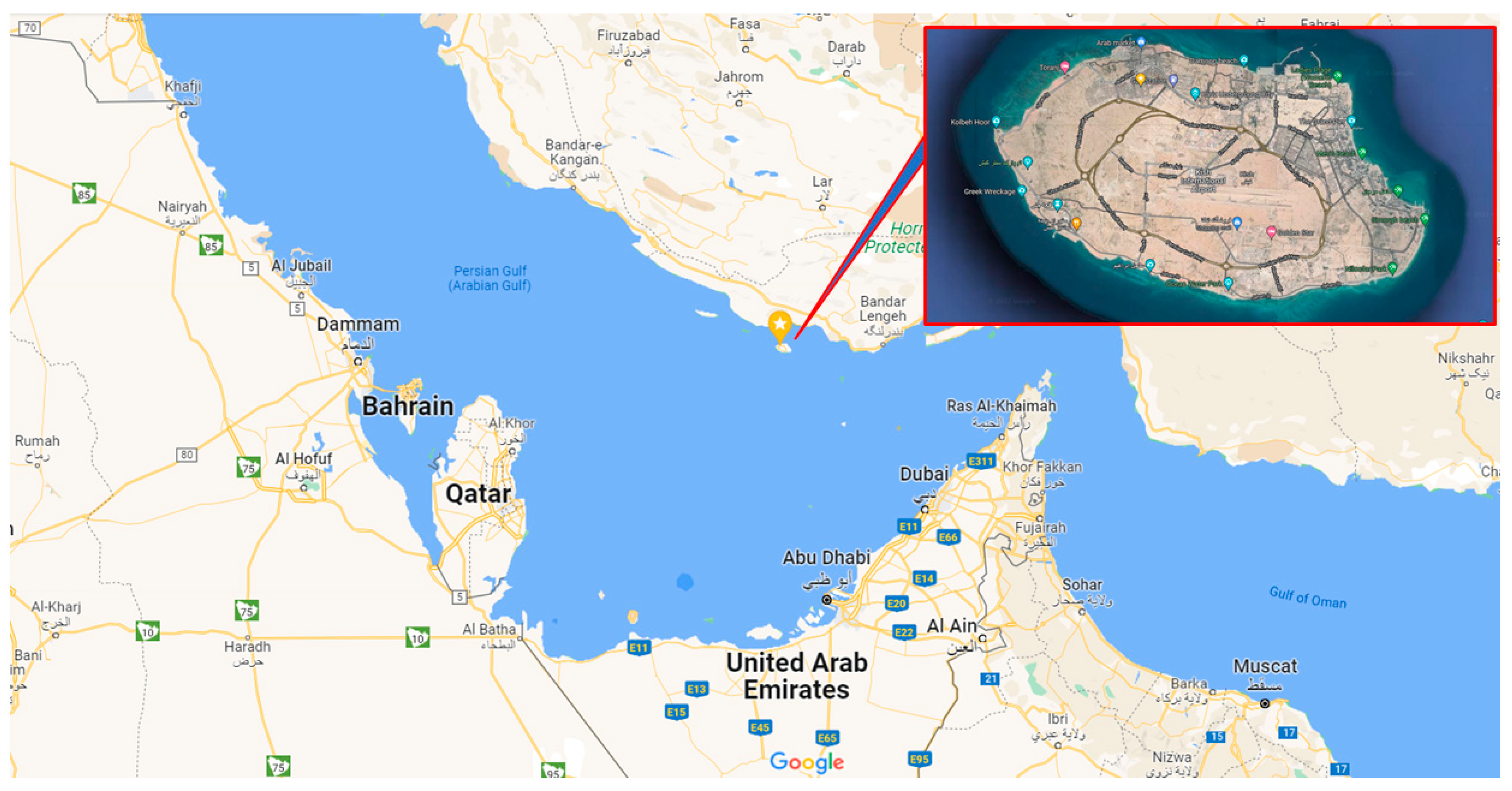
Kish is a small island in the Persian Gulf, 19 km off Iran’s mainland, with a 91 km2 surface area, a 40 km outer perimeter, and a nearly circular form as shown in Figure 1. The surface of the island is flat, with no mountains or even high hills. Its highest surface inclination extends from the airport, built in the center on an elevated area 35–40 m above sea level, to the shores [43].
Based on climate classification, in which the combined effect of precipitation and temperature are considered, Kish is a very dry area and its climatic condition generally is arid and semi-tropical. According to statistics, the average rainfall is about 180 mm, (65% in winter, 28% in fall, and 14% in the summer) and mean annual temperature is 26.6 °C [43,45].
Kish Island has the long sunshine hours—except for coastal areas of southeast and several other Persian Gulf islands—that is, about 3100 h a year; therefore, the annual evaporation is about 1650 mm, which is more than nine times the rainfall [43].
Considering the 20-year development perspective of Kish Island in various aspects, including tourism development and turning it into the top tourism destination for families, scientific-educational-research hub, sustainable development model using new technologies, and the most suitable place for investment in the Persian Gulf region, it can be expected to be accompanied by an increase in the need for drinking water for residents and tourists, as well as industrial development needs [43]. This increase in water demand along with climate change could lead to increase in water stress and consequent groundwater table depletion.
The touristic zone in the northeastern part of the island with an area of about 852 hectares is fully developed with moderate density, and involves residential areas, commercial and recreational centers, and has all the criteria required for this research: a developed urban area, adjacent to the sea, and a freshwater lens.
2.2. Methods
The proposed innovative approach introduces a new concept by modifying and juxtaposing the known techniques to provide the means of artificial recharge of aquifers using stormwater, without problems regarding other approaches, in cities. There are three key elements for any artificial recharge technique: firstly, to supply water, secondly, to convey it to a recharge facility, and finally, inject it into the aquifer.
The main goal of any stormwater management system is to ensure the safety of the city and its citizens against floods. Based on this, in almost all the cities around the world, stormwater management systems including channels, pipes, tunnels, etc., are already built or are under development in order to collect runoff from different areas and convey it safely to a receiving water body. Therefore, by default, a stormwater collection and conveyance system either exists in cities or is under construction. It should be noted that rainwater collected in this way is usually seen as a flood danger and threat, and the goal of such systems is usually to convey the collected runoff quickly and safely to the first safe place outside the urban environment. Obviously, the collected stormwater in coastal cities, as a source of free and accessible freshwater, is usually discharged into the sea and is wasted. In the proposed approach, this volume of wasted rainwater is used as a free and available source of freshwater to recharge groundwater.
As it is said, rainwater has already been used to artificially recharge groundwater; however, urban environmental conditions and limitations have made these methods unpopular or ineffective. Generally, two methods are used for artificial recharging of rainwater: spreading runoff over a wide area with good permeability, and local injection. Obviously, the first method, while efficient, is very expensive and non-optimal due to the need for large areas in urban environments (where land is scarce and precious), and the second method has always been used locally and in small areas, and is only able to deal with a very small volume of runoff, which could not have a considerable effect on the groundwater table.
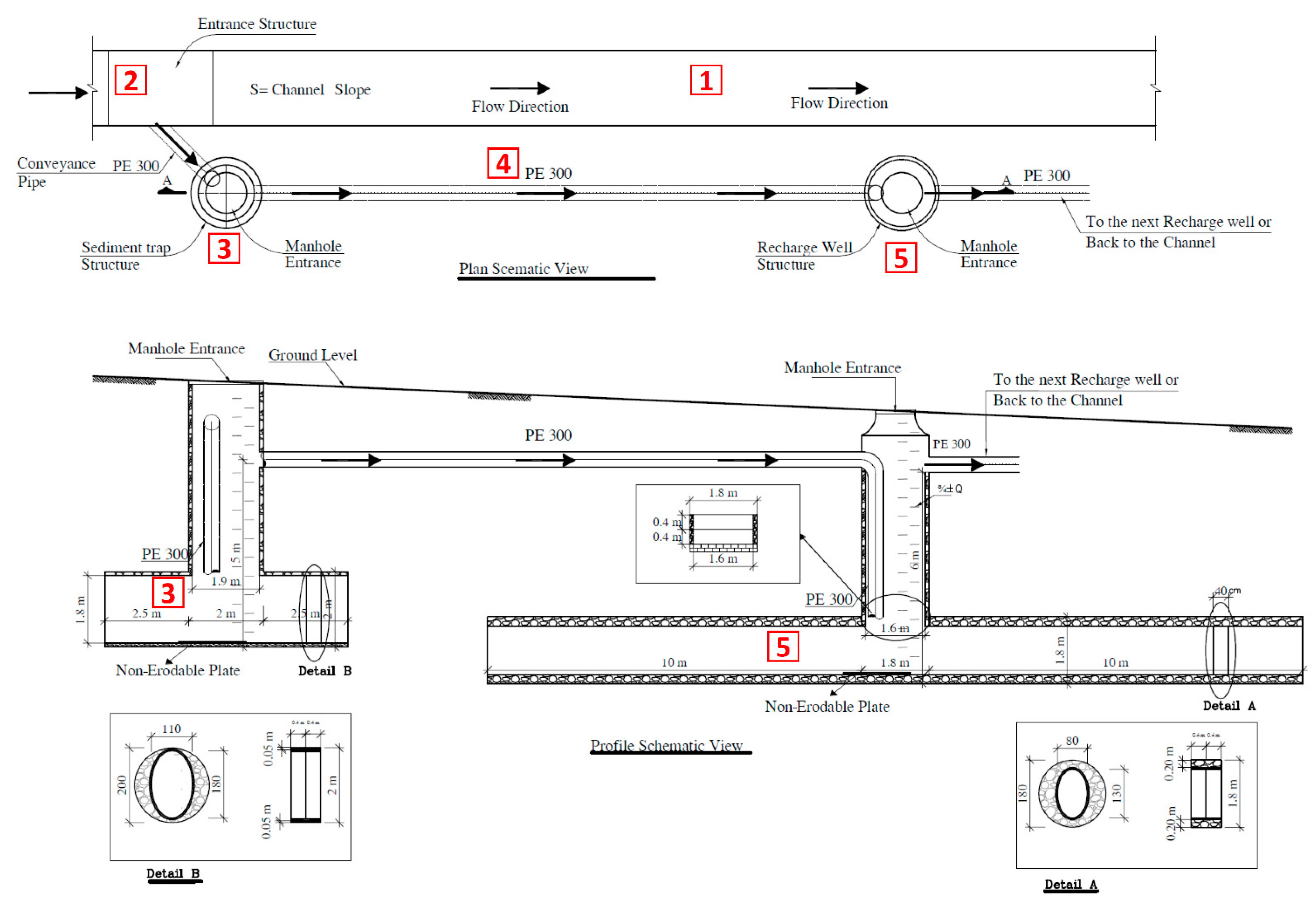
In the proposed new approach, recharge wells are modified in such a way that they work together as a recharge system, and integrate with the existing stormwater management system, especially channels, to change the traditional stormwater network into a recharge facility without affecting its hydraulic function as a stormwater management network; it receives, stores, and finally infiltrates runoff into aquifers while the whole network still plays its role protecting a city and its residents against floods. The recharge system is built in the vicinity of the channels and below the pavement level on the streets and passages; thus, there would be no need for any space allocation and its cost. There is also no need for special and sophisticated technologies to build them, and along with the modular design, it allows them to be implemented quite fast and inexpensively. Most importantly, it is possible to build them in large numbers in urban environments, and therefore it is possible to deal with a relatively significant volume of rainwater to artificially recharge the aquifer. A schematic view of the proposed system and its components is presented in Figure 2.
In the following, each element of the recharge system and how they work are introduced as numbered on the figure.
- The existing channel, while still playing its main role as a collector and flood conveyer in the stormwater management network, will also play a minor role as supplier of water for artificial recharge.
- The entrance structure has the role of diverting water from the existing channel to the recharge system by considering two crucial criteria: always, and even in low flows, it should be able to supply water for the recharge system and at the same time should not affect the hydraulic performance of the existing channel. Figure 3 shows a potential design for the entrance structure.
- The sediment trap structure acts as an interface between the stormwater network and recharge wells. This structure takes water from the existing channel, stores it, and increases retention time, trapping sediments, trash, and pollution to some extent. This structure is made of prefabricated concrete rings and is modular. The proposed bottom storage is cylindrical in shape with 1.1 × 1.8 m2 oval concrete rings and a length of 7 m, which creates a volume of about 12 m3. Due to the role of this structure, its entrance has been proposed with large dimensions, and circular concrete rings with an inner diameter of 1.9 m, to provide better operation and maintenance conditions. Since the exit point of this structure is about 5 m above its floor, 8.5 m3 are added to its volume and its total volume reaches 20.5 m3.
- Conveyance pipes are responsible for transferring water between the channel and the recharge system as well as between the structures themselves.
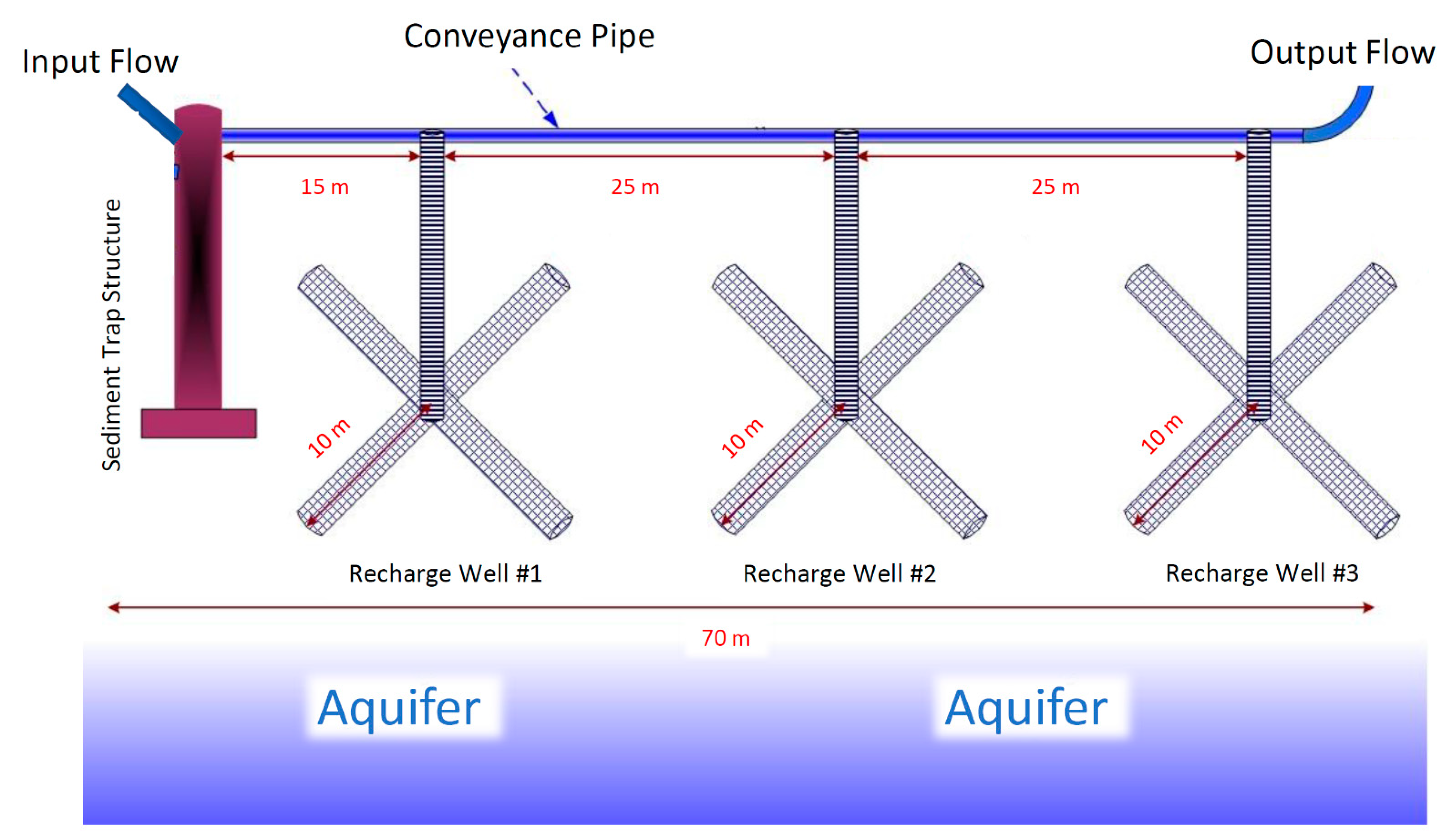
- Recharge wells are almost similar to sediment trap structures in terms of shape, with different dimensions and purpose. The proposed galleries are of cylindrical shape with 1.3 × 0.8 m2 oval concrete rings and a total length of 40 m, in the form of four interconnected crossed cylinders with 10 m length each. This creates a volume of about 45 m3 per recharge well. A recharge system is considered to be include up to three recharge wells according to the local conditions, which will eventually provide a volume of about 135 m3 per recharge system. A schematic view of a recharge system with three recharge wells is demonstrated in Figure 4.
In terms of performance, these modified recharge wells are actually a combination of conventional recharge wells and permeable tanks. The proposed technique is similar in form to recharge wells and benefits from its easy implementation and low cost; on the other hand, they function like permeable tanks by providing adequate storage volumes, considering the low rate of water infiltration into the soil layers, store water, and inject it at the required duration of time into the soil and finally the aquifer.
It should be noted that recharge wells are usually connected directly to the aquifer, and because of their limited penetration rate, they usually are not capable of recharging a significant volume of water into aquifers in a short time. Thus, usually in case of rainfall events and in exposure to large volumes of water, they will cause flooding in the surrounding street for a long period of time, if not fail totally. Moreover, it should be said that direct injection of water into the aquifer without proper filtration will cause possible contamination of the groundwater, while with the infiltrating water through the soil layers, pollution will be removed to a great extent before recharging the aquifer.
3. Results
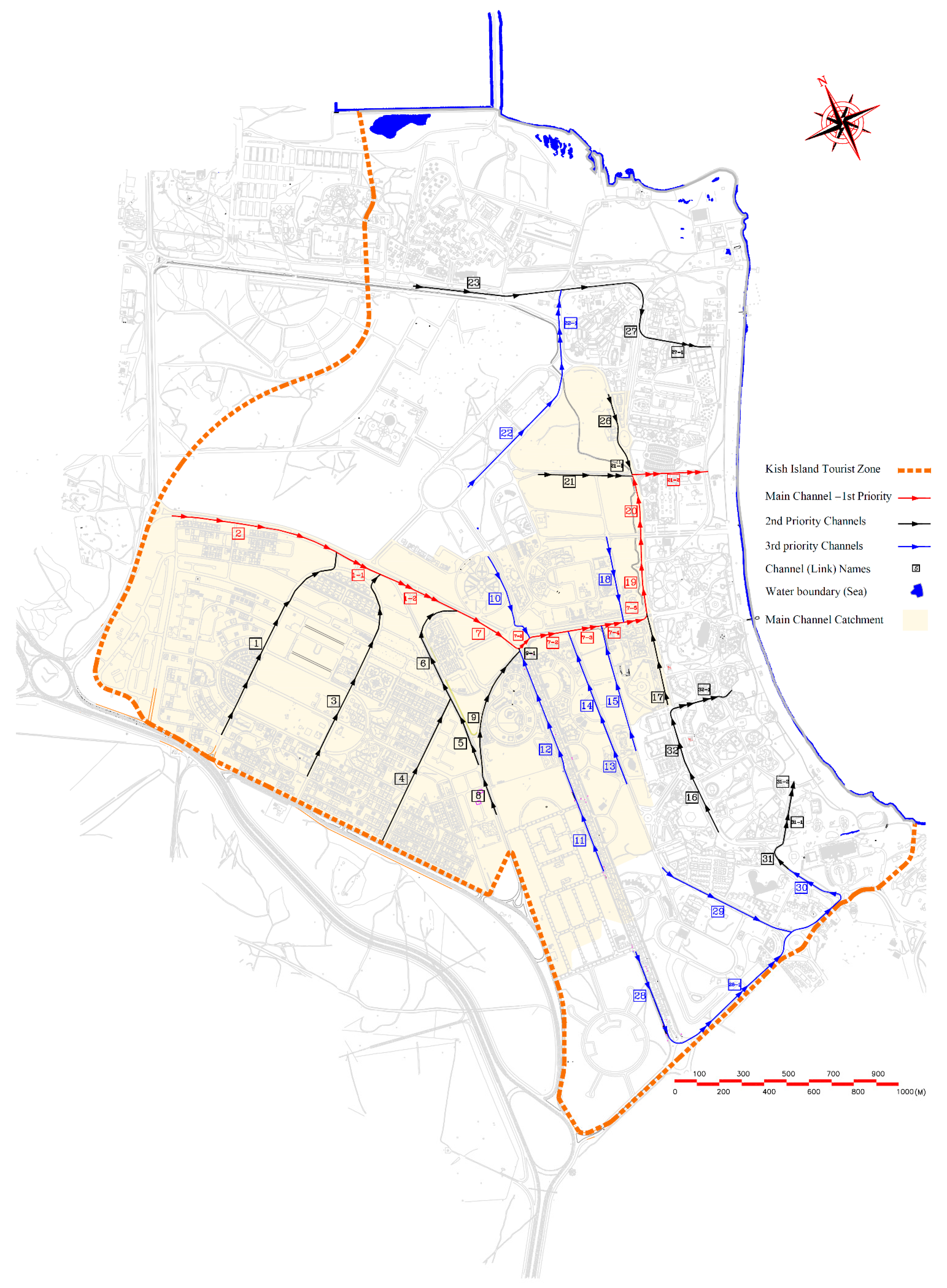
As explained earlier, one of the most important parts of any recharge system is the water supply. Therefore, the tourist zone of Kish Island is surveyed regarding the stormwater network, and it is determined that the stormwater management network is not developed yet, but its design has been completed and is awaiting construction. Figure 5 shows the overview of the designed channels of the mentioned stormwater network.
Table 1 summarizes the results of the precipitation of Kish Island based on its synoptic meteorological station.
The design results show that the main channel, which is shown in red color in Figure 5, with a catchment area of 350 ha, is the most important channel of this network, and about 40% of the catchment area and consequently runoff of the study area drains through it to the sea. The network is designed for 2 years return period rainfall and as presented in Table 2, the main channel is about 3.3 km long and its dimensions range from 1.0 × 0.8 m2 to 2.5 × 1.2 m2.
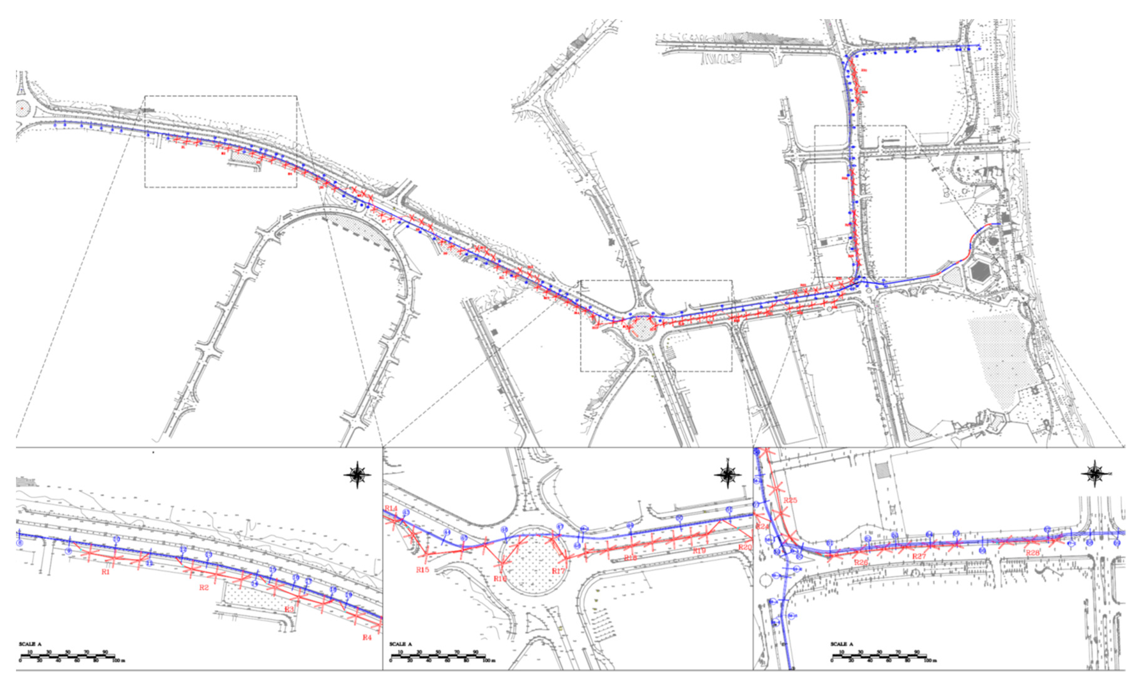
In order to determine the place of artificial recharge facilities, characteristics such as distance to groundwater aquifer, hydraulic gradient, and permeability of soil layers are considered. Accordingly, in the vicinity and parallel to the channel route, 33 recharge systems, each with 3 recharge wells for every 100 m of the channel length, were implemented; the results are shown in Figure 6. It has also been considered to keep a minimum depth of 1 m distance from groundwater (thickness of the unsaturated layer) so that proper filtration could happen alongside fast penetration.
The water infiltration rate by each well is calculated through the Darcy’s Law (1856):
where in:
Q = K × A × I,
Q = infiltration rate per well (m3/s)
K = permeability coefficient (m/s)
A = cross section area (m2)
I = hydraulic gradient
Infiltration happens through walls and horizontal galleries of each well. Since the amount of permeability coefficient in each channel route (3.3 km) is different, recharge rates are calculated separately for each recharge system and then a total amount is estimated. The recharge rate of a recharge system based on average values is calculated as follows.
The cross-sectional area from which the water will infiltrate is calculated separately for the wells and horizontal galleries. The depth of an average well is about 4 m, and its diameter is 1.8 m. Considering three wells in each system, the total cross-section of walls in each system is about 68 m2. Each well has four horizontal galleries; with 10 m length and 2 m outer diameter, the total cross-section of each well is 251 m2. As infiltration is heavily affected by gravity’s downward force, the infiltration flow is estimated to be about 0.6 of the cross section; therefore, the cross-sectional area of the galleries of each well will be about 151 m2. Altogether, the total cross-sectional area of a well and its galleries is about 174 m2, which will be 522 m2 for the whole recharge system.
Surface water infiltration is highest in the northeastern strips as well as in the southern part of the island due to the medium-to-high permeability of these areas. Most of the island has moderate permeability and, due to the constant spatial distribution of rainfall, infiltration rate is also moderate [46]. The permeability coefficient (K) was estimated in each recharge system according to the results of lugeon permeability tests in boreholes close to them. The average permeability in the proposed recharge systems is considered 2.4 × 10⁻⁵ ms−1. Consequently, the infiltration rate for this recharge system will be about 12.5 Ls−1. With the same calculations and assumptions, the recharge rates for all 33 proposed recharge systems are calculated and presented in Table 3.
The total infiltration rate of the proposed stormwater recharge systems is estimated to be about 422 Ls−1 and its total storage volume will be about 17,500 m3.
4. Discussion
Groundwater resources play an important role in human life and their environment, especially for coastal cities and islands due to their proximity to seawater and high possibility of saline water intrusion and consequent groundwater pollution. Kish Island is one of the few islands in the Persian Gulf that has fresh and extractable groundwater resource. However, research shows that this valuable resource is endangered for a couple of reasons: natural causes (such as rising sea levels and declining precipitation) and human activities (such as over-extraction of aquifers due to increasing water needs because of population growth and industrialization, as well as land-use change and continuous development).
In coastal aquifers, there is a high risk of seawater intrusion into groundwater resources and in this regard, the study of the vulnerability of groundwater resources are very important in determining the vulnerabilities and sensitive points of the aquifer. In a model with neural network training using synthetic data obtained from numerical modeling of freshwater lenses, a salinity water risk identification and risk management program for Kish Island was investigated to deal with changes [47]. In another study, the distribution map of electrical conductivity and water level in Kish Island was drawn by the minimum curvature method, and then the relationship between electrical conductivity and topography of the area was established. The results show that the amount of relative electrical conductivity is reduced; in other words, in the center of the island with a height of 33 m, the water level has reached a maximum height of 28.24 m and the relative electrical conductivity has reached a very low minimum of 0.046 [48]. More importantly, studying of Kish Island groundwater aquifer vulnerability using drastic modification model for the conditions of this coastal aquifer including parameter of sea water level difference with water stability level and point to sea distance, as well as recorded and sampled data on water quality of island wells, shows that 34.1% of the Kish Island aquifer has a very high vulnerability potential, 48.1% has a high vulnerability potential, and 17.8% has a medium vulnerability potential [46].
Due to these circumstances, the proposed artificial groundwater recharge system is able to supply freshwater to the aquifer in order to increase water quality and repel saline seawater, while increasing the amount of rainwater harvested. In this regard, studying statistics and data on the average rainfall and groundwater consumption can be informative.
Approximately, about 20% of the Kish Island’s precipitation (40 mm per year, equivalent to 3.6 MMm3 annually) penetrates the porous soil and recharges the freshwater lens of the island. According to existing plans, about 40 to 50 percent of this volume (16 to 20 mm annually, equivalent to 1.4 to 1.8 MMm3 annually) is extracted through existing wells. Therefore, the net recharge rate of the aquifer (total recharge minus extract) will be equal to 10 to 12% of the total annual rainfall of Kish Island (20 to 24 mm per year, equivalent to 1.8 to 2.2 MMm3 per year) [45,49,50].
In this regard, the study area with an area of 350 ha is approximately 4% of the total area of the island, and in general, this ratio can be expanded to net infiltration volume and give an estimation of about 70,000 m3 per year for this area. Regardless of the water infiltration rate and volume, the storage volume supplied by the proposed system is about 17,500 m3, equivalent to 25% of the area’s net infiltration volume. Generally, about 80% of rainfall volume is either evaporated or discharged into the sea, which will be about 14.4 MMm3 on average for the whole island and 570,000 m3 for the study area. This calculation shows that in a normal water year, it is theoretically possible to fill the system more than 30 times. Although this scenario might be too optimistic, it is quite obvious that there is enough water to fill this system, and even in a pessimistic scenario one can expect that this system will be filled up at least three times if precipitation occurs three times a year. This will mean more than 50,000 m3 of recharge to aquifer, which is a 75% rise in the current net amount.
There are two important points about the performance of this system. Firstly, the runoff in urban areas is expected to be collected and transferred through the stormwater management network to the outlet; since the stormwater network of the project area will be modified to also act as the collector and supplier of the recharge system, this indicates that it is actually a realistic estimation that a large portion of this water volume is available to the proposed recharge system. Secondly, Kish Island enjoys long sunny hours (up to 325 h per month in summer) and high temperatures (up to 36 °C in winter and up to 46 °C in spring), which generally means a very high evaporation rate; water stores in this system in underground galleries, and therefore it is safe from sunlight and evaporation, which is a big advantage for using this system in such conditions.
Environmental changes resulting from climate change including saline seawater intrusion, and changes in the precipitation, are of high sensitivity for groundwater management of any small island such as Kish Island. Simulations to determine the abstraction values and to control the advance of saline water towards the freshwater lens of the island show the importance of groundwater recharging in the study area. These simulations compare two important changes in rising seawater level and changes in precipitation in five scenarios: seawater level 1 m rise, 20% increase in the net recharge due to increased rainfall, seawater level 1 m rise and increase by 20% in the net recharge due to increased rainfall, 15% decrease in the net recharge due to decreased rainfall, and seawater level 1 m rise and decrease by 15% in the net recharge due to decreased rainfall. The research was performed based on the administrative areas of Kish Island and the results in different scenarios for the northeastern parts of the island, such as District 4 (case study area of this research), were worse than other parts [51].
The simulation results showed that the island freshwater lens thickness increased by 9.8% for Scenario 2, where the net recharge rate increased by 20%, and for Scenario 4, where the net recharge rate decreased by 15%, the lens thickness decreased by 9% [51]. Since the proposed recharge system is capable of adding a 24% to the net recharge rate only by filling up once a year, it is an easy conclusion that in the current situation (without increase in the precipitation), an increase in the thickness of the island’s freshwater lens by 10% could be expected. Furthermore, even in the net recharge rate reduction scenario, this system can compensate the decrease in precipitation and net recharge rate by filling only once a year, which is very pessimistic, while one could easily expect this system to fill up at least a few times during the year.
Sea level rise can significantly alter coastlines, especially in low-grade areas. Comparing the current conditions and the scenario of increasing the sea level by 1 m shows that the volume of freshwater lenses will be reduced due to the reduction in the island surface, and in this case the thickness of the lens will be reduced by 5.1%. Considering the simultaneous effect of sea level rise and increasing the net recharge rate by 20%, it can be seen that these two parameters will impact the freshwater lens of the island in opposite directions, and despite the sea level rise, compared to the current state, the island’s freshwater lens thickness will be increased by 5.2% [51]. This shows that even if the sea level rises, with recharging the proper amount of freshwater into the island aquifer, not only the thickness of the freshwater lens can be maintained, but also it can be improved. In the case of Kish Island, this issue can be easily met when the proposed recharge system is filled once a year and the recharge rate is increased by 25%.
Finally, the latest scenario is a 1 m increase in sea level and a 15% decrease in net recharge volume, which has the most adverse effect on the island’s freshwater lens. Reducing the net recharge rate shrinks the lens and has a synergistic effect with increasing the sea level. Under these conditions, the thickness of the lens will be decreased by 12.4% [51]. In this case, this adverse effect can be compensated by the proposed recharge system filling up only once a year, and even assuming that it is filled twice, the thickness of the freshwater lens can be improved.
Another point to consider is about the amount of water that can be harvested. Assuming that the current condition of water extraction from freshwater lens is stable, it can be thought that by increasing the net recharge rate, it will be possible to allow extraction of more water from the aquifer; as mentioned earlier, assuming the proposed system is filled only once, 25% more water would be available in the aquifer, which would be about 450,000 m3 per year if considered at the island level. Furthermore, in scenarios where the amount of precipitation decreases or the sea water level rises, it will be possible to maintain the current amount of water extraction by constructing the proposed system.
Another issue to discuss is the water infiltration rate, at the level of the study area and the proposed systems. The location of the recharge systems is determined based on the position of the main channel route, permeability, groundwater depth, and surface features. In general, the results of permeability tests show that the permeability is high near the shoreline (about 5.5 × 10⁻⁵ Ls−1) and decreases continuously with distance from it (about 1 × 10⁻⁵ Ls−1). On the other hand, the depth of groundwater near the shore is very shallow (about 2 m) and this depth increases with distance from the sea (up to 15 m). As it is shown in Figure 7, considering the conditions required to build a recharge system in the study area, three zones were defined. The red area, which is a narrow strip near the shoreline, although it enjoys a good permeability rate, due to the shallow depth of groundwater, it is not possible to build an efficient recharge system. The green area enjoys both good permeability rate and suitable groundwater depth, which makes the conditions ideal for the construction of a recharge system. The orange area has less permeability rate than others, and the groundwater depth has increased, and therefore recharge systems might not work as efficiently as in the green zone, and they will fulfill their functions at a slower rate.
According to the infiltration potential of each system, 33 proposed systems were divided into group A and group B. Group A includes 13 recharge systems that will recharge at the rate of 282 Ls−1 (67% of the total recharge rate), and group B includes 20 recharge systems that will have a 140 Ls−1 recharge rate, i.e., almost twice the number, and half the rate. Therefore, if authorities or decision makers want to prioritize the construction of these recharge systems based on the budget or limited time of construction, it is obvious that the first priority will be with the construction of Group A recharge systems (which are located in green zone) and then the second priority with the construction of Group B recharge systems (which are located in orange zone). It should be noted that apart from infiltration volume during rainfall, which is definitely much higher for Group A systems, in any case both systems will recharge the stored volume to the aquifer and the only difference will be in the time of recharge.
Stormwater infiltration systems are typically expected to drain down within 24 h of a storm, meaning that the infiltration rate should be high enough that no water is left ponding after 24 h [53]. The proposed recharge systems are located next to a stormwater network and preventing floods and providing flood protection is the main responsibility of mentioned stormwater network; yet, the proposed recharge systems are discharged in less than 24 h. Table 4 shows the time required to discharge for each of the recharge systems. In general, Group A recharge systems require between 6 and 10 h to discharge due to the high penetration rate, and Group B systems require between 18 and 23 h due to the lower penetration rate.
In general, it can be said that the sustainability of any society is in direct relation to the sustainability of its components, and certainly water security plays a crucial role in this regard. As the results showed, the proposed system is able to improve the conditions of the study area by increasing the groundwater level for future use, counteracting the seawater intrusion and climate change.
It is also noteworthy that in many urban communities, a large portion of the available water is used by industry, and not being able to support these industrial needs will cause much damage to this sector. The proposed groundwater recharge system is able to artificially recharge aquifers with rainwater in order to supply cheap and quality water to the industry.
In addition, from the general economic point of view, stability is one of the most important factors in attracting and maintaining capital. Establishing balance in water management and reducing the risk of water stress greatly contributes to the sustainability of the existing ecosystem and paves the way for its development and progress.
In terms of habitat and ecology, increasing the groundwater level using the proposed method to make more water available to plants and trees will help the ecosystem to be more stable and sustainable.
In addition to all these benefits that improve living conditions in cities and human societies, human dependence on clean water in terms of household needs and drinking is extremely high. The proposed system provides the community with more, cheaper, and cleaner water by recharging the aquifer, and consequently will reduce water stress and increase the sense of water security in societies.
5. Conclusions
One of the main pillars of development in human societies is the freshwater supply; without having enough renewable freshwater, no development will be sustainable. As human societies have always developed and their population grown rapidly, the consequent increasing water demand must be resolved. Due to the limited amount of freshwater available, groundwater is usually one of the first resources to be used as a replacement for scarcity. Excessive use of groundwater resources will lead to a drop in their level and cause many problems such as soil subsidence, reduced water quality, and seawater intrusion.
Groundwater has been extracted from aquifers over the years in various locations around the world, and either the impacts have become visible in many places or will become so soon; thus, providing a solution to this problem is an immediate necessity. One way to deal with these problems is to recharge groundwater artificially to compensate the lost water and bring balance to aquifers. There are many different ways in this regard, although usually these methods are not very effective in urban environments due to the need for large spaces or applicability in small basins; therefore, in this research a new approach is proposed to implement artificial recharge facilities in cities with high efficiency and without the negative aspects.
In general, the new proposed system, which is called the Groundwater Recharge System (GRS), works by modifying the existing stormwater management network and using it as a collector, supplier, and conveyer of water sources to enter the recharge systems installed in its vicinity and through its length, while their main objective, which is to ensure safety against floods, remains intact. The design and implementation of the mentioned system in the study area showed that even in the worst-case scenario, when this system is filled only once a year, it will be able not only to resolve many of the adverse effects of groundwater overuse, but also will be able to deal with the effects of climate change impacts such as precipitation reduction and rising sea levels. Along with all these advantages, perhaps the most important features of the proposed facility are its cheap and fast construction along with the lack of the need for complex technologies.
The proposed technique is also in direct line with the sixth goal of the United Nations’ Sustainable Development Goals (SDGs), clean water and sanitation, which is described as to ensure availability and sustainable management of water and sanitation for all. The mentioned goal has eight targets to achieve by the year 2030. The groundwater recharge system has a positive role in all of them, however, it is in direct line with target 6.6 (protect and restore water-related ecosystems, including mountains, forests, wetlands, rivers, aquifers, and lakes) and target 6.a (expand international cooperation and capacity-building support to developing countries in water- and sanitation-related activities and programs, including water harvesting, desalination, water efficiency, wastewater treatment, recycling, and reuse technologies), as the proposed technique uses water harvesting to protect aquifers [54].
Author Contributions
Conceptualization, A.M.-H.; methodology, A.M.-H.; software, A.M.-H.; validation, A.M.-H. and J.-L.M.; formal analysis, A.M.-H.; investigation, A.M.-H.; resources, A.M.-H.; data curation, A.M.-H.; writing—original draft preparation, A.M.-H.; writing—review and editing, A.M.-H. and J.-L.M.; visualization, A.M.-H.; supervision, J.-L.M.; project administration, A.M.-H. and J.-L.M. All authors have read and agreed to the published version of the manuscript.
Funding
This research received no external funding.
Institutional Review Board Statement
Not applicable.
Informed Consent Statement
Not applicable.
Data Availability Statement
Not applicable.
Conflicts of Interest
The authors declare no conflict of interest.
References
- Wada, Y.; van Beek, L.P.; Van Kempen, C.M.; Reckman, J.W.T.M.; Vasak, S.; Bierkens, M.F. Global depletion of groundwater resources. Geophys. Res. Lett. 2010, 37, L20402. [Google Scholar] [CrossRef] [Green Version]
- Hanasaki, N.; Kanae, S.; Oki, T.; Masuda, K.; Motoya, K.; Shirakawa, N.; Shen, Y.; Tanaka, K. An integrated model for the assessment of global water resources—Part 2: Applications and assessments. Hydrol. Earth Syst. Sci. 2008, 12, 1027–1037. [Google Scholar] [CrossRef] [Green Version]
- Alcamo, J.; Henrichs, T.; Rösch, T. World water in 2025: Global modeling and scenario analysis for the World Commission on Water for the 21st Century. In Kassel World Water Series; Center for Environmental Systems Research, University of Kassel: Kassel, Germany, 2000. [Google Scholar]
- FAO. Global Forest Resources Assessment 2010. FAO Forestry Paper 163; Food and Agriculture Organization of the United Nations: Rome, Italy, 2010. [Google Scholar]
- Boretti, A.; Rosa, L. Reassessing the projections of the world water development report. Npj Clean Water 2019, 2, 1–6. [Google Scholar] [CrossRef]
- Wada, Y.; Wisser, D.; Bierkens, M.F. Global modeling of withdrawal, allocation and consumptive use of surface water and groundwater resources. Earth Syst. Dynam. 2014, 5, 15–40. [Google Scholar] [CrossRef] [Green Version]
- World Bank. Annual Report 2010; World Bank: Washington, DC, USA, 2010. [Google Scholar]
- Kadam, A.K.; Umrikar, B.N.; Sankhua, R.N. Assessment of recharge potential zones for groundwater development and management using geospatial and MCDA technologies in semi-arid region of Western India. SN Appl. Sci. 2020, 2, 312. [Google Scholar] [CrossRef] [Green Version]
- Rhoades, J.D.; Kandiah, A.; Mashali, A.M. The use of saline waters for crop production. In FAO Irrigation & Drainage Paper; FAO: Rome, Italy, 1992. [Google Scholar]
- Eurostat. The Dominance of Capital Cities, Urban Europe—Statistics on Cities, Towns and Suburbs. 2016. Available online: https://ec.europa.eu/eurostat/statistics-explained/index.php?title=Archive:Urban_Europe_%E2%80%94_statistics_on_cities,_towns_and_suburbs_%E2%80%94_the_dominance_of_capital_cities&oldid=296362 (accessed on 10 April 2022).
- EEA (European Environment Agency). Use of Freshwater Resources in Europe. 2018. Available online: https://www.eea.europa.eu/data-and-maps/indicators/use-of-freshwater-resources-3/assessment-4 (accessed on 9 April 2022).
- WFD (Water Framework Directive). Directive 2000/60/EC of the European Parliament and of the Council of 23 October 2000. In Official Journal of the European Communities L 327/1; WFD: Rome, Italy, 2000. [Google Scholar]
- EEA (European Environment Agency). Water in the City. 2019. Available online: https://www.eea.europa.eu/signals/signals-2018-content-list/articles/close-up-2014-water-in (accessed on 19 March 2022).
- Kadam, A.; Karnewar, A.S.; Umrikar, B.; Sankhua, R.N. Hydrological response-based watershed prioritization in semi-arid, basaltic region of western India using frequency ratio, fuzzy logic and AHP method. Environ. Dev. Sustain. 2019, 21, 1809–1833. [Google Scholar] [CrossRef]
- USGS. Available online: https://www.usgs.gov/special-topics/water-science-school/science/groundwater-decline-and-depletion (accessed on 25 April 2022).
- CGR (Committee on Groundwater Recharge). Groundwater Recharge Using Water of Impaired Quality; National Academy Press: Washington, DC, USA, 1994. [Google Scholar]
- Mays, L.; Antoniou, G.P.; Angelakis, A.N. History of water cisterns: Legacies and lessons. Water 2013, 5, 1916–1940. [Google Scholar] [CrossRef] [Green Version]
- Texas Water Development Board. The Texas Manual on Rainwater Harvesting, 3rd ed.; Texas Water Development Board: Austin, TX, USA, 2005. [Google Scholar]
- Vieira, A.S.; Beal, C.D.; Ghisi, E.; Stewart, R.A. Energy intensity of rainwater harvesting systems: A review. Renew. Sustain. Energy Rev. 2014, 34, 225–242. [Google Scholar] [CrossRef] [Green Version]
- Belmeziti, A.; Olivier, C.; Bernard, D.G. A new methodology for evaluating potential for potable water savings (PPWS) by using rainwater harvesting at the urban level: The case of the municipality of Colombes (Paris region). Water 2013, 5, 312–326. [Google Scholar] [CrossRef]
- Liaw, C.H.; Chiang, Y.C. Dimensionless analysis for designing domestic rainwater harvesting systems at the regional level in northern Taiwan. Water 2014, 6, 3913–3933. [Google Scholar] [CrossRef] [Green Version]
- Campisano, A.; Gnecco, I.; Modica, C.; Palla, A. Designing domestic rainwater harvesting systems under different climatic regimes in Italy. Water Sci. Technol. 2013, 67, 2511–2518. [Google Scholar] [CrossRef] [PubMed]
- Hajani, E.; Rahman, A. Reliability and cost analysis of a rainwater harvesting system in peri-urban regions of greater Sydney, Australia. Water 2014, 6, 945–960. [Google Scholar] [CrossRef] [Green Version]
- Hussain, F.; Hussain, R.; Wu, R.S.; Abbas, T. Rainwater Harvesting Potential and Utilization for Artificial Recharge of Groundwater Using Recharge Wells. Processes 2019, 7, 623. [Google Scholar] [CrossRef] [Green Version]
- Rahman, A.; Keane, J.; Imteaz, M.A. Rainwater harvesting in Greater Sydney: Water savings, reliability and economic benefits. Resour. Conserv. Recycl. 2012, 61, 16–21. [Google Scholar] [CrossRef]
- Ghisi, E.; Tavares, D.F.; Rocha, V.L. Rainwater harvesting in petrol stations in Brasília: Potential for potable water savings and investment feasibility analysis. Resour. Conserv. Recycl. 2009, 54, 79–85. [Google Scholar] [CrossRef]
- Li, X.; Gong, J. Compacted micro-catchments with local earth materials for rainwater harvesting in the semiarid region of China. J. Hydrol. 2002, 257, 134–144. [Google Scholar] [CrossRef]
- Yuan, T.; Fengmin, L.; Puhai, L. Economic analysis of rainwater harvesting and irrigation methods, with an example from China. Agric. Water Manag. 2003, 60, 21–226. [Google Scholar] [CrossRef]
- Sazakli, E.; Alexopoulos, A.; Leotsinidis, M. Rainwater harvesting, quality assessment and utilization in Kefalonia Island, Greece. Water Res. 2007, 41, 2039–2047. [Google Scholar] [CrossRef]
- Goel, A.K.; Kumar, R. Economic analysis of water harvesting in a mountainous watershed in India. Agric. Water Manag. 2005, 71, 257–266. [Google Scholar] [CrossRef]
- Pandey, P.K.; Panda, S.N.; Panigrahi, B. Sizing on-farm reservoirs for crop-fish integration in rain-fed farming systems in Eastern India. Biosyst. Eng. 2006, 93, 475–489. [Google Scholar] [CrossRef]
- Islam, M.M.; Chou, F.F.; Kabir, M.R.; Liaw, C.H. Rainwater: A potential alternative source for scarce safe drinking and arsenic contaminated water in Bangladesh. Water Resour. Manag. 2010, 24, 3987–4008. [Google Scholar] [CrossRef]
- Mohammad, H.R.M.; Bahram, S.; Fereshte, H.F. Assessment of residential rainwater harvesting efficiency for meeting non-potable water demands in three climate conditions. Resour. Conserv. Recycl. 2013, 73, 86–93. [Google Scholar] [CrossRef]
- Fooladman, H.R.; Sepaskhah, A.R. Economic analysis for the production of four grape cultivars using micro-catchment water harvesting systems in Iran. J. Arid. Environ. 2004, 58, 525–533. [Google Scholar] [CrossRef]
- Ahmed, A.; Farooq, A. Study of rainwater harvesting potential in an industrial area using stormwater management model (SWMM V 5.0)—A case study of Quaid-E-Azam Apparel Park, Sheikhupura, Punjab, Pakistan. Int. J. Environ. Eng. 2018, 9, 185–198. [Google Scholar] [CrossRef]
- Siddiqui, R.; Siddiqui, S. Assessing the Rooftop Rainwater Harvesting Potential in Urban Residential Areas of Pakistan: A Case Study of Model Town, Lahore, Pakistan. Int. J. Econ. Environ. Geol. 2018, 9, 11–19. [Google Scholar]
- Hassan, I. Rainwater Harvesting-an alternative water supply in the Future for Pakistan. J. Biodivers. Environ. Sci. 2016, 8, 213–222. [Google Scholar]
- Song, J.; Han, M.; Kim, T. Rainwater harvesting as a sustainable water supply option in Banda Aceh. Desalination 2009, 248, 233–240. [Google Scholar] [CrossRef]
- Macomber, P.S.H. Guidelines on Rainwater Catchment Systems for Hawaii; College of Tropical Agriculture and Human Resources (CTAHR), University of Hawai‘i at Manoa: Honolulu, HI, USA, 2010; p. RM-12. [Google Scholar]
- Black, J.; Malesu, M.; Oduor, A.; Cherogony, K.; Nyabenge, M. Rainwater Harvesting Inventory of Kenya an Overview of Techniques, Sustainability Factors, and Stakeholders; World Agroforestry Centre (ICRAF): Nairobi, Kenya, 2012. [Google Scholar]
- Reddy, G.S.; Sandhya, S.; Hanumanthu, R. The Need of Artificial Recharge Techniques for Sustainable Development of Ground Water Resources. Int. J. Geol. Earth Sci. 2019, 5, 131–145. [Google Scholar] [CrossRef]
- Ministry of Water Resources. Guide on Artificial Recharge to Groundwater; Ministry of Water Resources: Delhi, India, 2000. [Google Scholar]
- Kish Free Zone Organization. Available online: https://portal.kish.ir/en (accessed on 24 April 2022).
- Polytechnic School of Ávila. Google Maps, 2022. Kish Island, 1:33,333 and 1:500. Google Maps [online]. Available online: https://www.google.com/maps (accessed on 24 April 2022).
- Ketabchi, H.; Ataie-Ashtiani, B. Evolutionary algorithms for the optimal management of coastal groundwater: A comparative study toward future challenges. J. Hyd. 2015, 520, 193–213. [Google Scholar] [CrossRef]
- Khoshdooz-Masooleh, N.; Babazadeh, H.; Tabatabaei, H.; Naderi, M. Modifying DRASTIC model to determine groundwater vulnerability in a coastal region. J. Water Soil Resour. Conserv. 2013, 1, 19–31. Available online: https://www.sid.ir/fa/journal/ViewPaper.aspx?id=218711 (accessed on 18 March 2022).
- Ketabchi, H.; Ataie-Ashtiani, B.; Rajabi, M. Providing practical solutions for optimal utilization of groundwater resources of small islands (Case study of Kish Island). In Proceedings of the 12th Iranian Hydraulic Conference, Karaj, Iran, 29 October 2013; Available online: https://civilica.com/doc/379263 (accessed on 10 April 2022).
- Atashkhar, F.; Shirani, M.; Tabatabaei, H. Relationship between some qualitative and quantitative parameters of groundwater resources in Kish Island. In Proceedings of the 1st National Conference on Coastal Lands, 8 December 2010; Water Resour. Manag. Available online: https://civilica.com/doc/105771 (accessed on 8 March 2022).
- Ataie-Ashtiani, B.; Rajabi, M.M.; Ketabchi, H. Inverse modeling for freshwater lens in small islands: Kish Island, Persian Gulf. Hydrol. Process 2013, 27, 2759–2773. [Google Scholar] [CrossRef]
- Ketabchi, H.; Ataie-Ashtiani, B. Development of combined ant colony optimization algorithm and numerical simulation for optimal management of coastal aquifers. IR-WRR 2010, 7, 1–12. [Google Scholar]
- Mahmoodzadeh, D.; Ketabchi, H.; Ataie-Ashtiani, B. Optimized Management of Groundwater Resources in Kish Island: A Sensitivity Analysis of Optimal Strategies in Response to Environmental Changes. Wat. Wastewater J. 2015, 2, 61–70. Available online: http://www.wwjournal.ir/article_12986.html (accessed on 17 March 2022).
- Polytechnic School of Ávila. Google Maps, 2022. Kish Island, 1:500. Google Maps [online]. Available online: https://www.google.com/maps (accessed on 24 April 2022).
- EPA (U.S. Environmental Protection Agency). Evaluation and Optimization of Bioretention Design for Nitrogen and Phosphorus Removal. 2013. Available online: https://www3.epa.gov/region1/npdes/stormwater/research/epa-final-report-filter-study.pdf (accessed on 20 March 2022).
- Department of Economic and Social Affairs, Sustainable Development. Available online: https://sdgs.un.org/goals/goal6 (accessed on 7 May 2022).
Figure 1.
Location of Kish Island, [44]: Google Maps, 2022. Kish Island, 1:33,333 and 1:500. Google Maps (online) Available through: Polytechnic School of Ávila https://www.google.com/maps (accessed on 24 April 2022).
Figure 1.
Location of Kish Island, [44]: Google Maps, 2022. Kish Island, 1:33,333 and 1:500. Google Maps (online) Available through: Polytechnic School of Ávila https://www.google.com/maps (accessed on 24 April 2022).

Figure 2.
Schematic view of the recharge wells system.

Figure 3.
Schematic view of a potential design of the entrance structure.

Figure 4.
Schematic view of the proposed recharge system.

Figure 5.
Designed stormwater management network.

Figure 6.
Proposed locations of recharge systems for the main channel.

Figure 7.
Permeability zones of the study area [52]: Google Maps, 2022. Kish Island, 1:500. Google Maps (online) Available through: Polytechnic School of Ávila https://www.google.com/maps (accessed 24 April 2022).
Figure 7.
Permeability zones of the study area [52]: Google Maps, 2022. Kish Island, 1:500. Google Maps (online) Available through: Polytechnic School of Ávila https://www.google.com/maps (accessed 24 April 2022).


Table 1.
Meteorology precipitation summary of Kish Island.
| Parameter | Fall | Winter | Spring | Summer | Yearly | ||||||||
|---|---|---|---|---|---|---|---|---|---|---|---|---|---|
| October | November | December | January | February | March | April | May | June | July | August | September | ||
| min | 0 | 0 | 0 | 0 | 0 | 0 | 0 | 0 | 0 | 0 | 0 | 0 | 24.8 |
| Ave | 2.35 | 8.32 | 46.7 | 35.83 | 28.58 | 36.1 | 8.67 | 1.27 | 5.03 | 1.68 | 1.31 | 0.57 | 175.54 |
| max | 64.8 | 57.3 | 189.6 | 126.3 | 209.6 | 273.3 | 67.7 | 30.2 | 100 | 56 | 38 | 19.5 | 496.1 |
| deviation | 11.26 | 13.95 | 53.97 | 36.28 | 45.6 | 57.85 | 16.51 | 5.22 | 20.33 | 9.46 | 6.45 | 3.29 | 116.79 |
| % | 1.34 | 4.74 | 26.6 | 20.41 | 16.28 | 20.56 | 4.94 | 0.72 | 2.86 | 0.96 | 0.75 | 0.32 | 100 |
| Sum | 57.37 | 100.51 | 14.97 | 3.56 | 100 | ||||||||
| % | 32.68 | 57.25 | 8.53 | 2.03 | 100 | ||||||||
Table 2.
Main channel characteristics.
| Channel | Area | Length | Width | Height | Slope | Q | |
|---|---|---|---|---|---|---|---|
| (ha) | (m) | (m) | (m) | (%) | (m3) | ||
| 1 | 2 | 37 | 761 | 1.00 | 0.80 | 0.30 | 0.89 |
| 2 | 1-1 | 77 | 216 | 1.10 | 1.00 | 0.50 | 1.60 |
| 3 | 1-2 | 112 | 380 | 1.10 | 1.00 | 0.85 | 2.15 |
| 4 | 7 | 169 | 324 | 1.50 | 1.00 | 0.75 | 3.22 |
| 5 | 7-1 | 239 | 67 | 1.50 | 1.00 | 1.20 | 4.03 |
| 6 | 7-2 | 253 | 174 | 1.50 | 1.00 | 1.50 | 4.26 |
| 7 | 7-3 | 274 | 151 | 1.50 | 1.00 | 1.50 | 4.68 |
| 8 | 7-4 | 283 | 101 | 1.50 | 1.00 | 1.20 | 4.84 |
| 9 | 7-5 | 303 | 122 | 2.00 | 1.00 | 1.20 | 5.22 |
| 10 | 19 | 317 | 373 | 2.50 | 1.20 | 0.30 | 5.40 |
| 11 | 20 | 322 | 256 | 2.50 | 1.20 | 0.35 | 5.42 |
| 14 | 21-2 | 350 | 338 | 2.50 | 1.20 | 0.35 | 5.86 |
Table 3.
Infiltration rates of proposed recharge systems.
| First Priority | Second Priority | ||||||
|---|---|---|---|---|---|---|---|
| Recharge | Depth | Permeability | Infiltration Rate | Recharge | Depth | Permeability | Infiltration Rate |
| System | (m) | (ms−1) | (Ls−1) | System | (m) | (ms−1) | (Ls−1) |
| R21 | 6.5 | 3.00 × 10⁻⁵ | 15.7 | R1 | 5 | 1.50 × 10⁻⁵ | 7.8 |
| R22 | 6.5 | 4.50 × 10⁻⁵ | 23.5 | R2 | 4.5 | 1.50 × 10⁻⁵ | 7.8 |
| R23 | 5 | 4.50 × 10⁻⁵ | 23.5 | R3 | 4 | 1.20 × 10⁻⁵ | 6.3 |
| R24 | 4.5 | 4.50 × 10⁻⁵ | 23.5 | R4 | 4 | 1.20 × 10⁻⁵ | 6.3 |
| R25 | 4.5 | 4.50 × 10⁻⁵ | 23.5 | R5 | 4.5 | 1.30 × 10⁻⁵ | 6.8 |
| R26 | 4.5 | 4.50 × 10⁻⁵ | 23.5 | R6 | 4.5 | 1.40 × 10⁻⁵ | 7.3 |
| R27 | 4.5 | 4.50 × 10⁻⁵ | 23.5 | R7 | 4.5 | 1.40 × 10⁻⁵ | 7.3 |
| R28 | 4.5 | 4.50 × 10⁻⁵ | 23.5 | R8 | 4 | 1.40 × 10⁻⁵ | 7.3 |
| R29 | 4 | 4.50 × 10⁻⁵ | 23.5 | R9 | 4 | 1.40 × 10⁻⁵ | 7.3 |
| R30 | 4 | 4.50 × 10⁻⁵ | 23.5 | R10 | 4 | 1.30 × 10⁻⁵ | 6.8 |
| R31 | 4 | 4.50 × 10⁻⁵ | 23.5 | R11 | 4 | 1.30 × 10⁻⁵ | 6.8 |
| R32 | 4 | 3.00 × 10⁻⁵ | 15.7 | R12 | 6 | 1.20 × 10⁻⁵ | 6.3 |
| R33 | 4 | 3.00 × 10⁻⁵ | 15.7 | R13 | 5.5 | 1.20 × 10⁻⁵ | 6.3 |
| R14 | 5 | 1.30 × 10⁻⁵ | 6.8 | ||||
| R15 | 4.5 | 1.30 × 10⁻⁵ | 6.8 | ||||
| R16 | 4.5 | 1.30 × 10⁻⁵ | 6.8 | ||||
| R17 | 4.5 | 1.30 × 10⁻⁵ | 6.8 | ||||
| R18 | 4.5 | 1.30 × 10⁻⁵ | 6.8 | ||||
| R19 | 4.5 | 1.30 × 10⁻⁵ | 6.8 | ||||
| R20 | 5.5 | 1.50 × 10⁻⁵ | 7.8 | ||||
Table 4.
Duration to infiltrate from full storage to empty storage of proposed recharge systems.
| Group A | Group B | ||||||
|---|---|---|---|---|---|---|---|
| Recharge | Storage | Infiltration Rate | Duration | Recharge | Storage | Infiltration Rate | Duration |
| System | (m3) | (Ls−1) | (h.) | System | (m3) | (Ls−1) | (h.) |
| R21 | 536.0 | 15.7 | 9.5 | R1 | 527.6 | 7.8 | 18.8 |
| R22 | 536.0 | 23.5 | 6.3 | R2 | 524.8 | 7.8 | 18.7 |
| R23 | 527.6 | 23.5 | 6.2 | R3 | 522.0 | 6.3 | 23.0 |
| R24 | 524.8 | 23.5 | 6.2 | R4 | 522.0 | 6.3 | 23.0 |
| R25 | 524.8 | 23.5 | 6.2 | R5 | 524.8 | 6.8 | 21.4 |
| R26 | 524.8 | 23.5 | 6.2 | R6 | 524.8 | 7.3 | 20.0 |
| R27 | 524.8 | 23.5 | 6.2 | R7 | 524.8 | 7.3 | 20.0 |
| R28 | 524.8 | 23.5 | 6.2 | R8 | 522.0 | 7.3 | 19.9 |
| R29 | 522.0 | 23.5 | 6.2 | R9 | 522.0 | 7.3 | 19.9 |
| R30 | 522.0 | 23.5 | 6.2 | R10 | 522.0 | 6.8 | 21.3 |
| R31 | 522.0 | 23.5 | 6.2 | R11 | 522.0 | 6.8 | 21.3 |
| R32 | 522.0 | 15.7 | 9.2 | R12 | 533.2 | 6.3 | 23.5 |
| R33 | 522.0 | 15.7 | 9.2 | R13 | 530.4 | 6.3 | 23.4 |
| R14 | 527.6 | 6.8 | 21.6 | ||||
| R15 | 524.8 | 6.8 | 21.4 | ||||
| R16 | 524.8 | 6.8 | 21.4 | ||||
| R17 | 524.8 | 6.8 | 21.4 | ||||
| R18 | 524.8 | 6.8 | 21.4 | ||||
| R19 | 524.8 | 6.8 | 21.4 | ||||
| R20 | 530.4 | 7.8 | 18.9 | ||||
Publisher’s Note: MDPI stays neutral with regard to jurisdictional claims in published maps and institutional affiliations. |
© 2022 by the authors. Licensee MDPI, Basel, Switzerland. This article is an open access article distributed under the terms and conditions of the Creative Commons Attribution (CC BY) license (https://creativecommons.org/licenses/by/4.0/).
Share and Cite
MDPI and ACS Style
Mohammad-Hosseinpour, A.; Molina, J.-L. Improving the Sustainability of Urban Water Management through Innovative Groundwater Recharge System (GRS). Sustainability 2022, 14, 5990. https://0-doi-org.brum.beds.ac.uk/10.3390/su14105990
AMA Style
Mohammad-Hosseinpour A, Molina J-L. Improving the Sustainability of Urban Water Management through Innovative Groundwater Recharge System (GRS). Sustainability. 2022; 14(10):5990. https://0-doi-org.brum.beds.ac.uk/10.3390/su14105990
Chicago/Turabian StyleMohammad-Hosseinpour, Abedin, and José-Luis Molina. 2022. "Improving the Sustainability of Urban Water Management through Innovative Groundwater Recharge System (GRS)" Sustainability 14, no. 10: 5990. https://0-doi-org.brum.beds.ac.uk/10.3390/su14105990
Note that from the first issue of 2016, this journal uses article numbers instead of page numbers. See further details here.