
Sustainability and Resilience of Indigenous Siberian Communities under the Impact of Transportation Infrastructure Transformation

 , , and
Abstract
:1. Introduction
2. Related Works
3. Methods
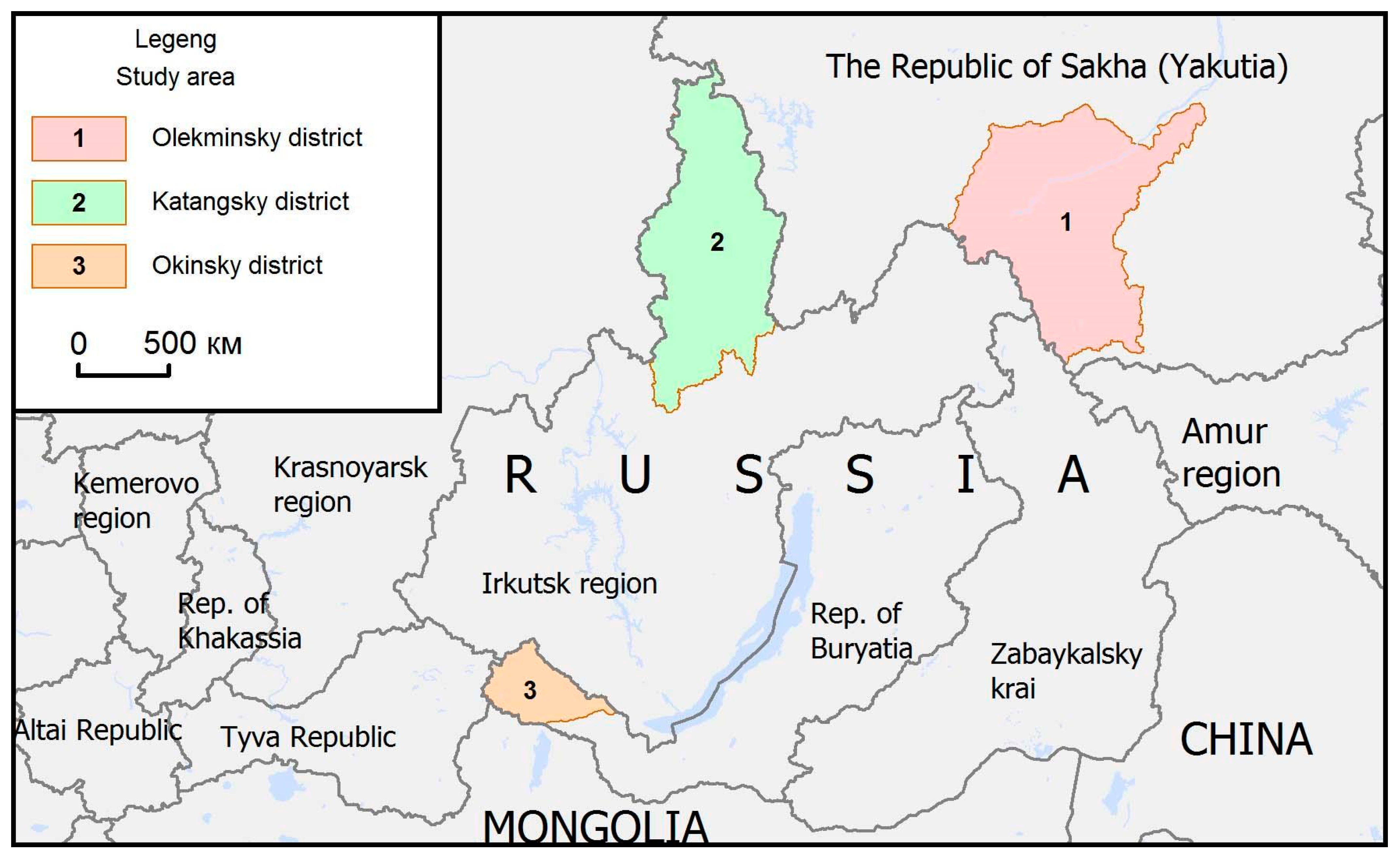
4. Study Area
5. Result and Discussion
- -
- In the Olekminsky district, there is a transformation of the transportation infrastructure and the heterogeneity of the network of transport communications on different time scales.
- -
- Since the middle of the 17th century, the main supply route for Yakutia was the “water-land route from Tobolsk through Yeniseisk along the Angara-Ilim rivers, the Ilimsky (Lensky) portage and rafting from Ust-Kuta along the Lena to Yakutsk”, which passed through the Olekminsky district, the Irkutsk-Yakutsk postal route established in 1738 allowed for the organization of regular postal communication and contributed to the emergence of new settlements (post stations) and an increase in the number of settlements in the form of machine tools, which led to an increase in the population in the area. The route, which ran along the Lena River, was year-round and served trade and postal traffic, as well as the transportation of passengers and exiles from Irkutsk to Yakutsk. In winter, transportation was mainly on the ice of the river. Lena to Yakutsk, in the summer, was by boat.
- -
- In the post-Soviet period, many settlements were abolished after the administrative reform of 1963 in connection with the clarification of the concept of “permanent settlement”. In particular, there were not many rural settlements located near the city of Olekminsk. There is a policy of enlargement of settlements here, when unpromising small villages were closed, and their population was relocated to larger settlements, which are mainly centers of collective farms and state farms. In Soviet times, an extensive network of scattered winter roads was created to supply artels, geological parties and meteorological stations that appeared here later.
- -
- Since the early 2000s, there has been a change in the specialization of the region from a purely agrarian (agricultural) type, with the development of animal husbandry, reindeer husbandry, grain and fodder production, potato growing, vegetable growing, milk processing, etc., to an agrarian-industrial type, the development of agricultural and gold mining industries Neryungri-Metallik LLC (gold deposits “Tabornoe”, “Gross”, etc.), construction of oil and gas pipelines “ESPO” and “Power of Siberia”, laying of power lines, exploration of hydrocarbon raw materials, development of the forest and woodworking industries, etc.
- -
- At present, new types and categories of roads have appeared, and the construction of a network of technological roads for industrial companies operating in the region is being developed. In the territories of traditional nature management, technological roads have both positive and negative effects. The positive impact is the limited provision of access to travel and transportation of goods for the local population, both in personal transport and in transport provided by companies. The maintenance of technological roads is carried out by industrial companies themselves, which does not impose additional costs on the local budget. The negative impact is manifested in noise pollution by heavy equipment, which scares away the objects of hunting, as a result, the migration of game animals changes; there is an increase in cases of environmental pollution by fuel spills and the number of accidents. For example, in a number of cases, residents of the Olekminsky district, upon obtaining a travel permit, can use the technological road of the East Siberia–Pacific Ocean oil pipeline to access the Lena federal highway and travel to Yakutsk to receive social services.
- -
- A significant part of the territory of the region, where the indigenous peoples of the North live, does not have a permanent year-round surface road network, which negatively affects the quality of life. Thus, in terms of transport accessibility, the Olekminsky district can be put on a par with the Arctic regions of the Republic of Sakha (Yakutia), which is one of the most inaccessible territories of the republic, given that the region does not have a program to subsidize airfare.
6. Conclusions
- remoteness of the territories promotes preservation of traditional activities of indigenous peoples.
- works related to exploitation of mineral deposits contribute to upgrading transportation infrastructure, offering new opportunities for residents living in the territory.
- a poor road network is concurrently conducive to generating additional income for the local population providing the missing transportation services.
Author Contributions
Funding
Institutional Review Board Statement
Informed Consent Statement
Data Availability Statement
Conflicts of Interest
References
- National Remote and Regional Transport Strategy. Available online: https://dipl.nt.gov.au/__data/assets/pdf_file/0005/1032278/national-remote-regional-transport-strategy.pdf (accessed on 3 March 2021).
- Strategy for the Spatial Development of the Russian Federation for the Period Up to 2025. Approved by Decree of the Government of the Russian Federation Dated February 13 No. 207-r. 2019. Available online: http://government.ru/docs/35733/ (accessed on 3 March 2021).
- Transport Strategy of the Russian Federation for the Period up to 2030 Dated November 22, 2018 No. 1734-r, Approved by the Government of the Russian Federation. Available online: http://www.consultant.ru/document/cons_doc_LAW_82617/12dbe84ab7402c41a061dee3399c090bf6932cc3/ (accessed on 5 November 2021).
- Kuklina, V.V. Transportation Accessibility: Experience and Practices of Mobility of Residents of Settlements in the National Republics of Siberia. In The Collection of Scientific Papers Based on the Results of the All-Russian Scientific and Practical Seminar: Republics in the East of Russia: Trajectories of Economic, Demographic and Territorial Development; Breslavsky, A.S., Ed.; IMBT SB RAS: Ulan-Ude, Russia, 2018; pp. 222–237. Available online: https://0-doi-org.brum.beds.ac.uk/10.30792/978-5-7925-0522-3-2018-222-237 (accessed on 3 May 2022).
- Development and Integration of Remote Areas in the APEC Region. APEC Policy Support Unit. November, 2018. Available online: https://www.apec.org/docs/default-source/Publications/2018/11/Development-and-Integration-of-Remote-Areas-in-the-APEC-Region/218_PSU_Remote-areas-development.pdf (accessed on 3 May 2022).
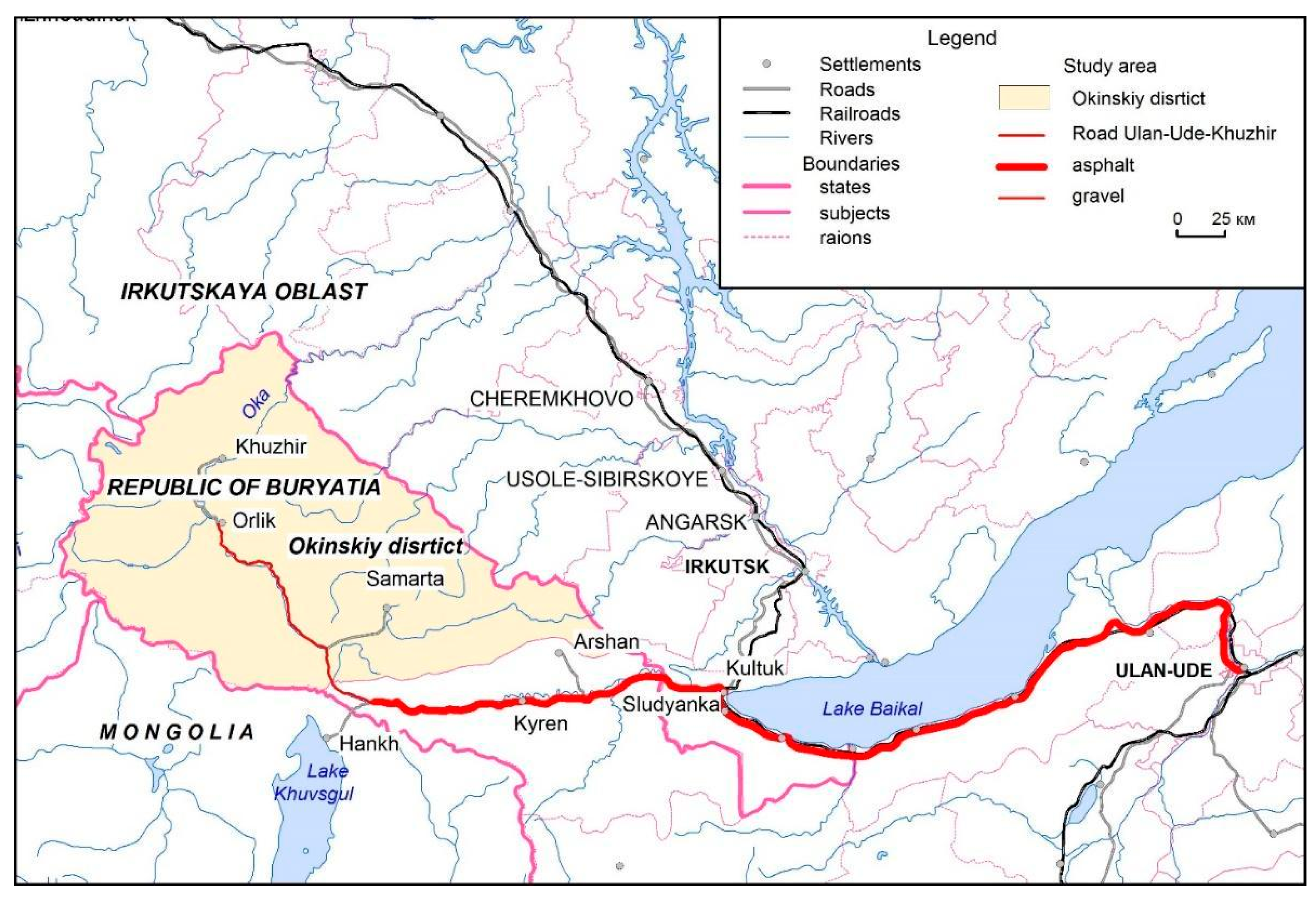
- Kuklina, M.V.; Trufanov, A.I. Prospects for the development of sustainable tourism in the Okinsky district of the Republic of Buryatia. Sustainability 2021, 13, 8042. [Google Scholar] [CrossRef]
- Jarvie, M.E. Brundtland Report. Encyclopedia Britannica. 2016. Available online: https://www.britannica.com/topic/Brundtland-Report (accessed on 3 May 2022).
- Sala, S.; Ciuffo, B.; Nijkamp, P. A systemic framework for sustainability assessment. Ecol. Econ. 2015, 119, 314–325. [Google Scholar] [CrossRef]
- Jacob-Lopes, E.; Zepka, L.; Depra, M. Sustainability Metrics and Indicators of Environmental Impact. Industrial and Agricultural Life Cycle Assessment; Elsevier: Amsterdam, The Netherlands, 2021. [Google Scholar] [CrossRef]
- Jamieson, D. Sustainability and beyond. Ecol. Econ. 1998, 24, 183–192. [Google Scholar] [CrossRef] [Green Version]
- De Vries, B.J.M.; Petersen, A.C. Conceptualizing sustainable development. Ecol. Econ. 2009, 68, 1006–1019. [Google Scholar] [CrossRef] [Green Version]
- Five Environmental Metrics Worth Tracking. 2021. Conservice ESG. Available online: https://www.gobyinc.com/five-environmental-sustainability-metrics-worth-tracking/ (accessed on 2 May 2022).
- Remoteness. Development Statistics and Information Branch. 2021. UNCTAD. Available online: https://sdgpulse.unctad.org/remoteness/ (accessed on 2 May 2022).
- Schweitzer, P.; Povoroznyuk, O.; Schiesser, S. Beyond wilderness: Towards an anthropology of infrastructure and the built environment in the Russian North. Pol. J. 2017, 7, 58–85. [Google Scholar] [CrossRef] [Green Version]
- Schweitzer, P.; Stammler, F.; Ebsen, C.; Ivanova, A.; Litvina, I. Social Impacts of Non-Renewable Resource Development on Indigenous Communities in Alaska, Greenland, and Russia//ReSDA Gap Analysis Report. 2016. Available online: http://yukonresearch.yukoncollege.yk.ca/resda/wp-content/uploads/sites/2/2013/09/2-Schweitzer-Gap-analysis-final.pdf (accessed on 3 May 2022).
- Konstantinov, Y. Roadlessness and the Person: Mode of Travel in the Reindeer Herding Part of the Kola Peninsula. Acta Borealia 2009, 1, 27–49. [Google Scholar] [CrossRef]
- Golovnev, A.V. Nomads of the North: Mentality and mobility. New Stud. Tuva 2019, 3, 15–26. [Google Scholar]
- Golovnev, A.V.; Belorussova, S.; Kisser, T.S. Essays on the Anthropology of Movement; MAE RAN: St. Petersburg, Russia, 2020; p. 336. [Google Scholar]
- Forbes, B.; Stammler, F.; Kumpula, T.; Meschtybd, N.; Pajunena, A.; Kaarlejarvi, E. High resilience in the Yamal-Nenets social–ecological system, West Siberian Arctic, Russia. Proc. Natl. Acad. Sci. USA 2009, 106, 22041–22048. [Google Scholar] [CrossRef] [Green Version]
- Cresswell, T. The Right to Mobility: The Production of Mobility in the Courtroom. Antipode 2006, 38, 735–754. [Google Scholar] [CrossRef]
- Kwan, M.P. Beyond Space (As We Knew It): Toward Temporally Integrated Geographies of Segregation, Health, and Accessibility. Ann. Assoc. Am. Geogr. 2013, 103, 1078–1086. [Google Scholar] [CrossRef]
- Niedzielski, M.A.; Boschmann, E.E. Travel Time and Distance as Relative Accessibility in the Journey to Work. Ann. Assoc. Am. Geogr. 2014, 104, 1156–1182. [Google Scholar] [CrossRef]
- Soder, M.; Peer, S. The potential role of employers in promoting sustainable mobility in rural areas: Evidence from Eastern Austria. Int. J. Sustain. Transp. 2017, 12, 541–551. [Google Scholar] [CrossRef] [Green Version]
- Australian Population and Migration Research Centre. ARIA (Accessibility/Remoteness Index of Australia). Australian Population and Migration Research Centre. URL. Available online: https://www.adelaide.edu.au/apmrc/research/projects/category/about_aria.html.1 (accessed on 15 February 2022).
- Nelson, A. Travel Time to Major Cities: A Global Map of Accessibility. European Commission. URL. Available online: http://forobs.jrc.ec.europa.eu/products/gam/ (accessed on 16 February 2022).
- Bugromenko, V.N. Transport in Territorial Systems; The Science: Moscow, Russia, 1987; p. 112. [Google Scholar]
- Bugromenko, V.N. Transport discrimination of the population: Ways to solve problems. Ind. Policy Russ. Fed. 2003, 1, 8–22. [Google Scholar]
- Rodoman, B.B. Spatial polarization and reorientation. In Where is Russia Going? Transformation of the Social Sphere and Social Policy; Case: Moscow, Russia, 1998; pp. 178–192. [Google Scholar]
- Tarkhov, S.A. Evolutionary Morphology of Transport Networks; Universe: Smolensk, Russia, 2005; p. 386. [Google Scholar]
- Golts, G.A. Transport and Settlement; The Science: Moscow, Russia, 1981; p. 248. [Google Scholar]
- Tarkhov, S.A.; Shlikhter, S.B. Geography of Transport Systems: A Course of Lectures; ROU, IG RAN: Moscow, Russia, 1995; p. 148. [Google Scholar]
- Lazerovich, E.E. Economic Microdistricts of Russia (Grid and Typology); Trilobite: Moscow, Russia, 2004; p. 128. [Google Scholar]
- Krylov, P.M. Typologization of modern regional transport systems of Russia. Reg. Res. Russia 2007, 4, 66–75. [Google Scholar]
- Privalovsky, A.N. Typology of Local Transport Systems of Russia; Transport: Moscow, Russia, 1985; p. 183. [Google Scholar]
- Neretin, A.S. Transportation Situation and Accessibility of the Territories of European Russia: Abstract of the Dissertation of the Candidate of Geographical Sciences, 25.00.24; Institute of Geography RAS: Moscow, Russia, 2018; p. 26. [Google Scholar]
- Bolshakov, N.M.; Zhideleva, V.V.; Rabkin, S.V. Transportation accessibility of peripheral rural territories: Theory, methodology, practice (case study of the Komi republic). Proc. Komi Sci. Cent. Ural. Div. Russ. Acad. Sci. 2015, 2, 95–103. [Google Scholar]
- Bolshakov, N.M.; Eremeeva, L.E.; Popov, E.Y. Methodological Approaches to Assessing the Transportation Accessibility of the Territoryю Actual Problems, Directions and Mechanisms of Development of the Productive Forces of the North: Materials of the Fifth All-Russian Scientific Seminar; OOO “Komirepublican Printing House”: Syktyvkar, Russia, 2016; pp. 135–242. [Google Scholar]
- Lavrinenko, P.A.; Romashina, A.A.; Stepanov, P.S.; Chistyakov, P.A. Transportation accessibility as an indicator of regional development. Probl. Forecast. 2019, 6, 136–146. [Google Scholar]
- Pilyasov, A.N.; Zamyatina, N.Y.; Goncharov, R.V. There is no creativity without mobility: Anthropology of transport in Siberia and the Far East. Spat. Econ. 2019, 15, 149–183. [Google Scholar] [CrossRef] [Green Version]
- Marshalova, A.S.; Novoselov, A.S. Competitiveness and Development Strategy of Municipalities. Region: Econ. Sociol. 2010, 3, 219–236. Available online: https://www.researchgate.net/publication/46525363_Competitiveness_and_development_strategies_for_municipal_units/link/5e4cf94f458515072da8b53a/download (accessed on 5 November 2021).
- Heckathorn, D. Comment: Snowball versus Respondent-Driven Sampling. Sociol. Methodol. 2011, 41, 355–366. [Google Scholar] [CrossRef] [Green Version]
- Kusenbach, M. Street phenomenology: The go-along as ethnographic research tool. Ethnography 2003, 4, 455–485. [Google Scholar] [CrossRef]
- Imetkhenov, A.B. (Ed.) Atlas of the Republic of Buryatia; Federal Service of Geodesy and Cartography of Russia: Moscow, Russia, 2000; p. 48. [Google Scholar]
- Rassadin, I.V. Comparative Analysis of Animal Husbandry of Soyots and Buryats. Humanit. Vector 2017, 12, 190–195. Available online: http://zabvektor.com/wp-content/uploads/080219030207-rassadin.pdf (accessed on 10 November 2021).
- Kurdyukov, V.N. Traditional Soyot Economy and Its Dynamics. Bull. Irkutsk. State Univ. 2012, 1, 176–185. Available online: https://izvestiageo.isu.ru/en/article/file?id=5 (accessed on 10 November 2021).
- Gulgenova, S.Z. The History of the Development of Traditional Nature Management in the Oka Mountains (Eastern Sayan). Bull. Buryat State Univ. 2009, 4, 24–26. Available online: https://cyberleninka.ru/article/n/istoriya-razvitiya-traditsionnogo-prirodopolzovaniya-v-gornoy-oke-vostochnyy-sayan (accessed on 10 November 2021).
- Imethenov, O.A. Aliber Mine 2013—High-Rise Anthropogenic Landscape Park of Regional Importance (Eastern Sayan). Bull. Buryat State Univ. 2013, 4, 32–35. [Google Scholar]
- Khamnaeva, S.L.; Torpinkeeva, S.L. Dynamics of the tourist flow and prospects for the development of tourism in the Okinsky district, Sustainable development of service technology. In Proceedings of the VII International Student Scientific and Practical Conference, Ulan-Ude, Russia, 12–14 June 2018; East Siberian State University of Technology and Management: Ulan-Ude, Russia, 2018; pp. 172–177. [Google Scholar]
- Kropotkin, P.A. Documents on the History of Literature and the Public 1923; State Publishing House: Moscow, Russia, 1923; Volume 4, p. 291. [Google Scholar]
- Kuklina, V.; Dashpilov, T. Constructing a transport communication map of the “Sayan Crossing”. Tartaria Magna 2013, 2, 12–40. [Google Scholar]
- Volkov, S. “Okinsky district. Baikal land./S. Volkov.—Text: Electronic// Baikal land [Electronic resource].—2004. Octobe URL. Available online: http://baikal.irkutsk.ru/php/statya.php?nomer=29.txt&razdel=buriatia (accessed on 10 October 2021).
- Information About the Landing Sites on the Territory under the Jurisdiction of the Aircraft of the MTU of the Federal Air Transport Agency, as of 09/26/2018. [Electronic Resource]—URL. Available online: https://favt.gov.ru/aviaciya-obshego-haznacheniya-posadochnie-ploshadki-aerodromy/ (accessed on 10 October 2021).
- Kazaryan, P.L. Land Communications of North-Eastern Russia (XVII Century—1920); NEFU: Yakutsk, Russia, 2012; p. 143. [Google Scholar]
- Olekminsk Residents Have Been Fighting for a Year-Round Road for More Than A Dozen Years, and Who is Still There. Available online: https://sakhaday.ru/news/olekminchane-byutsya-za-kruglogodichnuyu-dorogu-ne-pervyi-desyatok-let-a-voz-i-nyne-tam?from=copy (accessed on 26 February 2022).
- The Official Website of the Municipal District “Olekminsky”. Available online: https://mr-olekminskij.sakha.gov.ru/ (accessed on 19 January 2022).
- Pesterev, V.I. Formation and Development of Air Transport in Yakutia (1923–1945); YSC: Yakutsk, Russia, 1993; p. 20. [Google Scholar]
- Olekminsk Air Harbor—65 Years. Available online: http://gazetaolekma.ru/news/2007-11-15-2444 (accessed on 18 February 2022).
- The Official Website of the Federal State Enterprise “Airports of the North”. Available online: http://sever.aero (accessed on 2 February 2022).
- Small Island Developing States. DGFF2021. (2022) UNCTAD Development and Globalization: Facts and Figures 2021–461 pages. Available online: https://unctad.org/system/files/official-document/dgff2021_en.pdf (accessed on 2 May 2022).
- Cantu-Bazaldua, F. Remote but Well Connected? Neighboring but Isolated? Measuring Remoteness in the Context of SIDS. UNCTAD/SER.RP/2021/10. UNCTAD Research Paper No. 67; UNCTAD: Geneva, Switzerland, 2021. [Google Scholar]
- Zubala, T. Effect of transport infrastructure development on selected components of the environment of inner-city river valley and the possibility of its revitalization. Environ. Sci. Pollut. Resour. 2022. [Google Scholar] [CrossRef]
- Wang, L.; Xue, X.; Zhao, Z.; Wang, Z. The Impacts of Transportation Infrastructure on Sustainable Development: Emerging Trends and Challenges. Int. J. Environ. Res. Public Health 2018, 15, 1172. [Google Scholar] [CrossRef] [Green Version]
- Griškevičiūtė-Gečienė, A.; Griškevičienė, D. The Influence of Transport Infrastructure Development on Sustainable Living Environment in Lithuania. Procedia Eng. 2016, 134, 215–223. [Google Scholar] [CrossRef] [Green Version]
- Laurance, W.F.; Clements, G.R.; Sloan, S.; O’Connell, C.S.; Mueller, N.D.; Goosem, M.; Venter, O.; Edwards, D.P.; Phalan, B.; Balmford, A. A global strategy for road building. Nature 2014, 513, 229–232. [Google Scholar] [CrossRef]
- Palmer, M.A. Water resources: Beyond infrastructure. Nature 2010, 467, 534–535. [Google Scholar] [CrossRef]
- Quigley, R.; Thornley, L. Literature Review on Community Cohesion and Community Severance: Definitions and Indicators for Transport Planning and Monitoring. Report to New Zealand Transport Agency. 2011. 52p. Available online: https://www.nzta.govt.nz/assets/resources/community-cohesion-and-community-severance/docs/community-cohesion-and-community-severance.pdf (accessed on 5 May 2022).
- Impact of Transport Infrastructure Investment on Regional Development. OECD. 2002. Available online: https://www.itf-oecd.org/sites/default/files/docs/02rtrinveste.pdf (accessed on 5 May 2022).
- Nimegeer, A.; Thomson, H.; Foley, L.; Hilton, S.; Crawford, F.; Ogilvie, D. Experiences of connectivity and severance in the wake of a new motorway: Implications for health and well-being. Soc. Sci. Med. 2018, 197, 78–86. [Google Scholar] [CrossRef] [PubMed]
- The Yakut Evenks Asked Gazprom Not to Lay a Gas Pipeline Through Their Lands. Available online: https://www.newsru.com/finance/15feb2011/evenki.html (accessed on 26 January 2022).
- Filippova, V.V. Access to territories of traditional nature management: Mobility of local communities in conditions of industrial development. Kunstkamera 2020, 1, 36–42. [Google Scholar] [CrossRef] [Green Version]
- In Connection with the Damage to the Tokko River and the Surrounding Area, Materials are Being Prepared for the Initiation of a Criminal Case. Available online: https://yakutia.info/article/198787 (accessed on 25 February 2022).


| Female, education worker, 50, Khuzhir, Okinsky district | ”Khuzhir Enterprise is our partner. We opened a bakery at the school and Khuzhir Enterprise buys bread from us every day. Our school is autonomous and these are our non-budgetary funds, but it’s true that a lot of money is spent on flour, because it’s far to carry, and flour is expensive, but nevertheless we have some money. Last year we bought 3 TVs, and now we are ordering printers to provide all teachers with them. It helps a lot. This is also additional help for children when they go to the city for some kind of competition and we pay half of the costs from outside the budget”. |
| Male, administration worker, 49, Orlik, Okinsky district | “The imprint is made by mountainous terrain, the landscape itself, medium mountains, over 1000 m, all settlements are located at an altitude of over 1000 m. It turns out that we are completely in the mountains, and accordingly we have our own specifics and nuances that leave an imprint in connection with the weather and climatic conditions and the landscape itself, well, in fact, our difficulties. …. And in this regard, we have many moments here that are not found in other regions. First of all, these are infrastructural aspects, the transportation component, energy, communications. Well, all this comes to us on the sly. The road appeared only in 1992”. |
| Male, local, 60, Khuzhir, Okinsky district | “You see, we have three gold mining factories, we have jade everywhere. And simultaneously we have nothing. Everything leaves for Moscow. These are gold mining factories which belong to Muscovites”. |
| Female, local, 40, Khuzhir, Okinsky district | “But there are also disadvantages. There, dust rises from the factory with the wind, it goes here, I guess. This summer, our cows and calves began to die for no reason. Everyone thinks they are due to emissions from the Khuzhir Enterprise”. |
| Male, local, 57, Olekminsk, Olekminskiy district | “We used to get to our lands unhindered, but on deer. When the ESPO road appeared, we began to travel by car. This is good, because we can carry more cargo and travel more often. On the one hand, it’s good that an alternative road has appeared, but on the other hand, it turns out that we need the permission of “foreigners” to get to our lands”. |
| Male, local, 43, Olekminsk, Olekminskiy district | “In the first years of the ESPO, in order to travel to the hunting grounds and deer pastures, we issued a pass that was valid for one year. Now you need a pass for every entry. To do this, we send an application to the company and in three days we receive a pass. This is very inconvenient if you need to go urgently. We need to plan in advance, but we are used to what we wanted today—we left today. It’s always been that way”. |
| Male, administration worker, 58, Tyanya, Olekminskiy district | “There are no year-round roads; in winter, from January to April, a winter road operates along the Tyanya-Tokko-Chara-Olekma rivers, and in summer on motorboats along the same rivers. During the thaw (April-May, October-December), the AN-2 plane flies two times a week, tickets are subsidized, the ticket price is 3–4 thousand rubles. Planes may not arrive due to bad weather, rain, as the runway is unpaved. In 2006, a gas station was opened, fuel prices are expensive, we have to import fuel and lubricants by winter road for the whole year”. |
| Male, reindeer breeder, 52, Tyanya, Olekminskiy district | “I work in the community as a reindeer herder, the herd is located near the border with the Trans-Baikal Territory, not far from Neryungri Metallik. We buy products from them, since I myself am from the village of Chapa-Ologo of the Trans-Baikal Territory, I go to visit my relatives along their route. It is 16 km from the Tabornoy deposit to the Ikabya railway station by car. If you go from the herd to the village of Tyanya, then first you need to go by all-terrain vehicle from Ivanakit to the mouth of the Usu, from there to the Charoda river and along the Tokko river for 2 days by motorboat”. |
| Female, local, 62, Tyanya, Olekminskiy district | “Locals for sale, many take lingonberries, blueberries, blackcurrants on motorboats. In winter, from the village of Tyani to the village of Tokko, we drive one road in UAZs through the Dabayan-Chara River-Byas-Kyuel-Neftebaza-Chara River-Tokko River, and from there to the city of Olekminsk. By car 5 h to the village of Byas-Kyuel, then 2 h to the village of Tokko. In December, the winter road is not yet open, so we go on snowstorms to the village of Byas-Kyuel. The administration of the village and Neryungri-Metallik used to service the winter road, but now I don’t know who wins the tender, they carry out the work”. |
| Female, local, 68 years old, Tyanya, Olekminskiy district | “There is a lot of equipment, many have motorboats, gasoline is expensive, but there is no choice. To get to Olekminsk, 120–140 L of gasoline are required, depending on the engine. Boat motor power—25 hp only here it’s not far to drive near the house, 30 hp normal for old people, 40 hp already for the young, for long trips to the city of Olekminsk and for those who carry passengers and cargo. When there is little water on the river, sometimes the motors break, although the locals know the river well”. |
| Male, administration worker, 65 years old, Nepa, Katangsky district | “We live in a very remote area, and this puts a certain imprint on our existence here. In particular, on the development of entrepreneurial activity, it is impossible to develop entrepreneurial activity, because transportation logistics are not provided here, even the products that will be produced here cannot be delivered to the markets. This is the main obstacle to development of small and medium-sized enterprises. Large enterprises, of course, work here, this is the oil and gas industry, it is flourishing and developing. They have their own transportation logistics, their own roads, which they do not open for public use, they use only themselves”. |
| Female, administration worker, 50 years old, Erbogachen, Katangsky district | “Now the issue of building a year-round road to Preobrazhenka, it is next to the oil field, but it is still worked out… There is the year-round technological road between the fields and from this road 17 km winter road to Preobrazhenka, but it is only if Preobrazhenka is connected, and we will be outside”. |
| Male, Local, 60 years old, Erbogachen, Katangsky district | “Allow us to drive there [on the technological road], as if there were “a lot of” us, and there you can drive three times faster, on the winter road we were going 20 km/h, and on their road 60 without straining”. |
Publisher’s Note: MDPI stays neutral with regard to jurisdictional claims in published maps and institutional affiliations. |
© 2022 by the authors. Licensee MDPI, Basel, Switzerland. This article is an open access article distributed under the terms and conditions of the Creative Commons Attribution (CC BY) license (https://creativecommons.org/licenses/by/4.0/).
Share and Cite
Kuklina, M.; Savvinova, A.; Filippova, V.; Krasnoshtanova, N.; Bogdanov, V.; Fedorova, A.; Kobylkin, D.; Trufanov, A.; Dashdorj, Z. Sustainability and Resilience of Indigenous Siberian Communities under the Impact of Transportation Infrastructure Transformation. Sustainability 2022, 14, 6253. https://0-doi-org.brum.beds.ac.uk/10.3390/su14106253
Kuklina M, Savvinova A, Filippova V, Krasnoshtanova N, Bogdanov V, Fedorova A, Kobylkin D, Trufanov A, Dashdorj Z. Sustainability and Resilience of Indigenous Siberian Communities under the Impact of Transportation Infrastructure Transformation. Sustainability. 2022; 14(10):6253. https://0-doi-org.brum.beds.ac.uk/10.3390/su14106253
Chicago/Turabian StyleKuklina, Maria, Antonina Savvinova, Viktoria Filippova, Natalia Krasnoshtanova, Viktor Bogdanov, Alla Fedorova, Dmitrii Kobylkin, Andrey Trufanov, and Zolzaya Dashdorj. 2022. "Sustainability and Resilience of Indigenous Siberian Communities under the Impact of Transportation Infrastructure Transformation" Sustainability 14, no. 10: 6253. https://0-doi-org.brum.beds.ac.uk/10.3390/su14106253