
Parameterization in the Analysis of Changes in the Rural Landscape on the Example of Agritourism Farms in Kłodzko District (Poland)


Abstract
:
1. Introduction
2. Literature Review
2.1. The Agritourism Farm in the Context of the Multi-Functionality of Rural Areas
- Specific open landscape;
- Low population density;
- Predominance of people involved in farming, forestry and tourism;
- Traditional lifestyle (close to nature) and cultivation of customs;
- Agricultural and forestry use of land;
- Sparse buildings and dispersed settlement;
- Inhabitants’ feeling of living in the countryside.
2.2. Methods of Valuating the Rural Landscape
- Assessment of the natural value of individual elements;
- Aesthetic and visual assessment of valuable landscapes;
- Valuation of landscape for a specific purpose.
- Natural valorization;
- Cultural valorization;
- Agricultural production space valorization;
- Landscape aesthetic assessment;
- Valorization for different forms of recreation;
- Assessment of the degree of anthropogenic transformation of the environment;
- Assessment of conflicts and conflict areas.
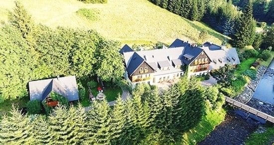
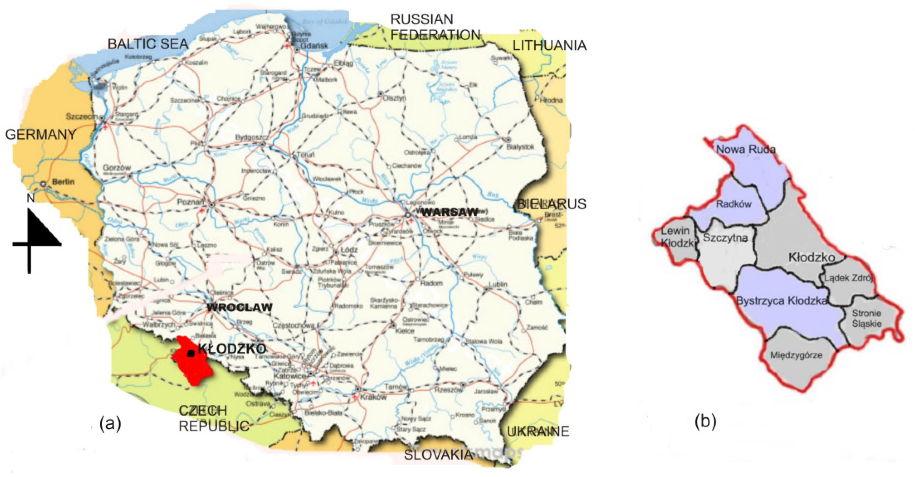
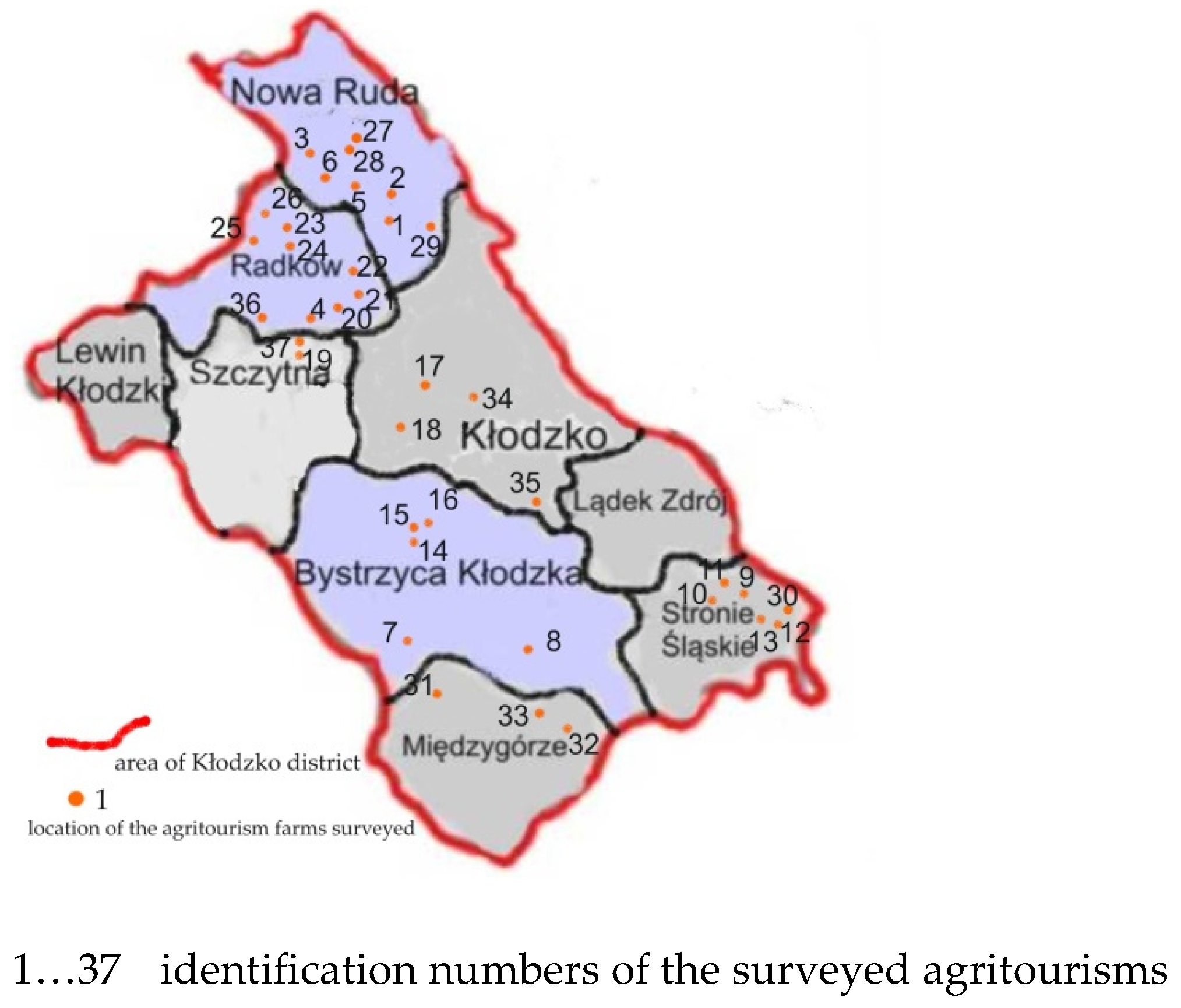
3. Study Area
4. Methodological Approach
4.1. Research Trial
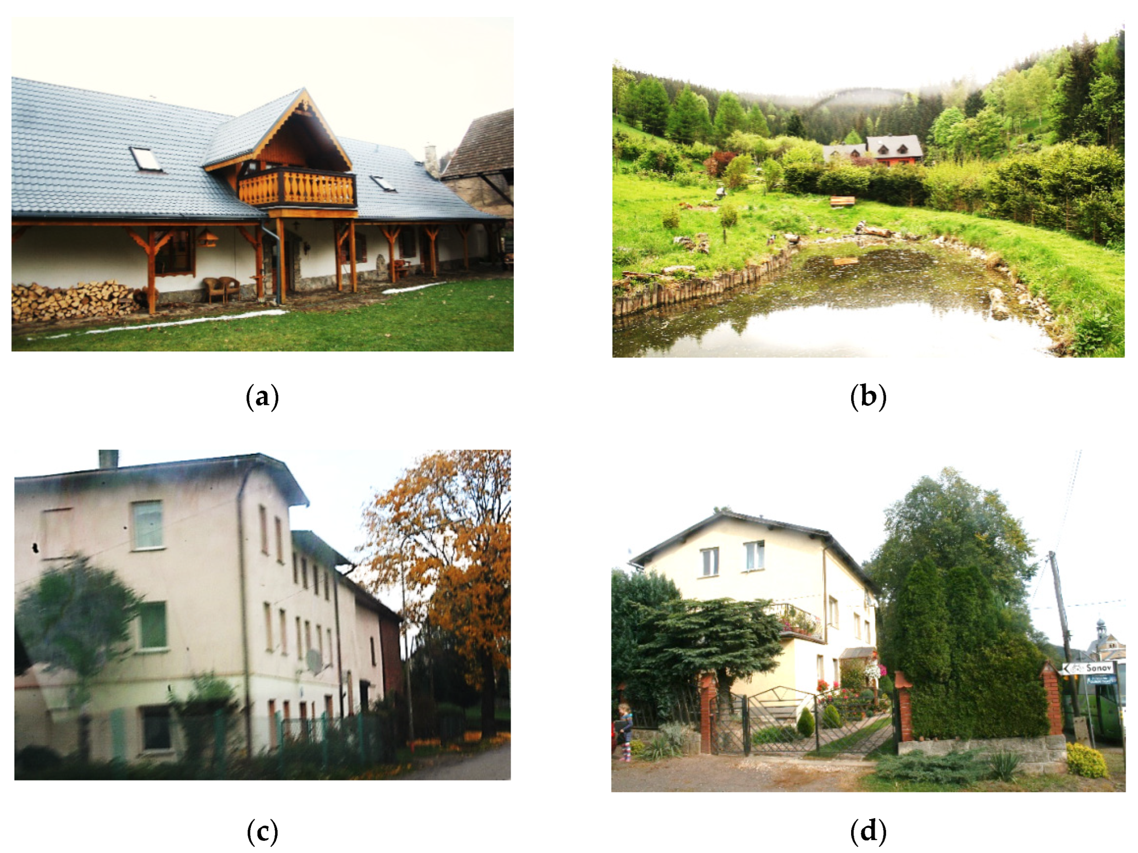
4.2. Field Research
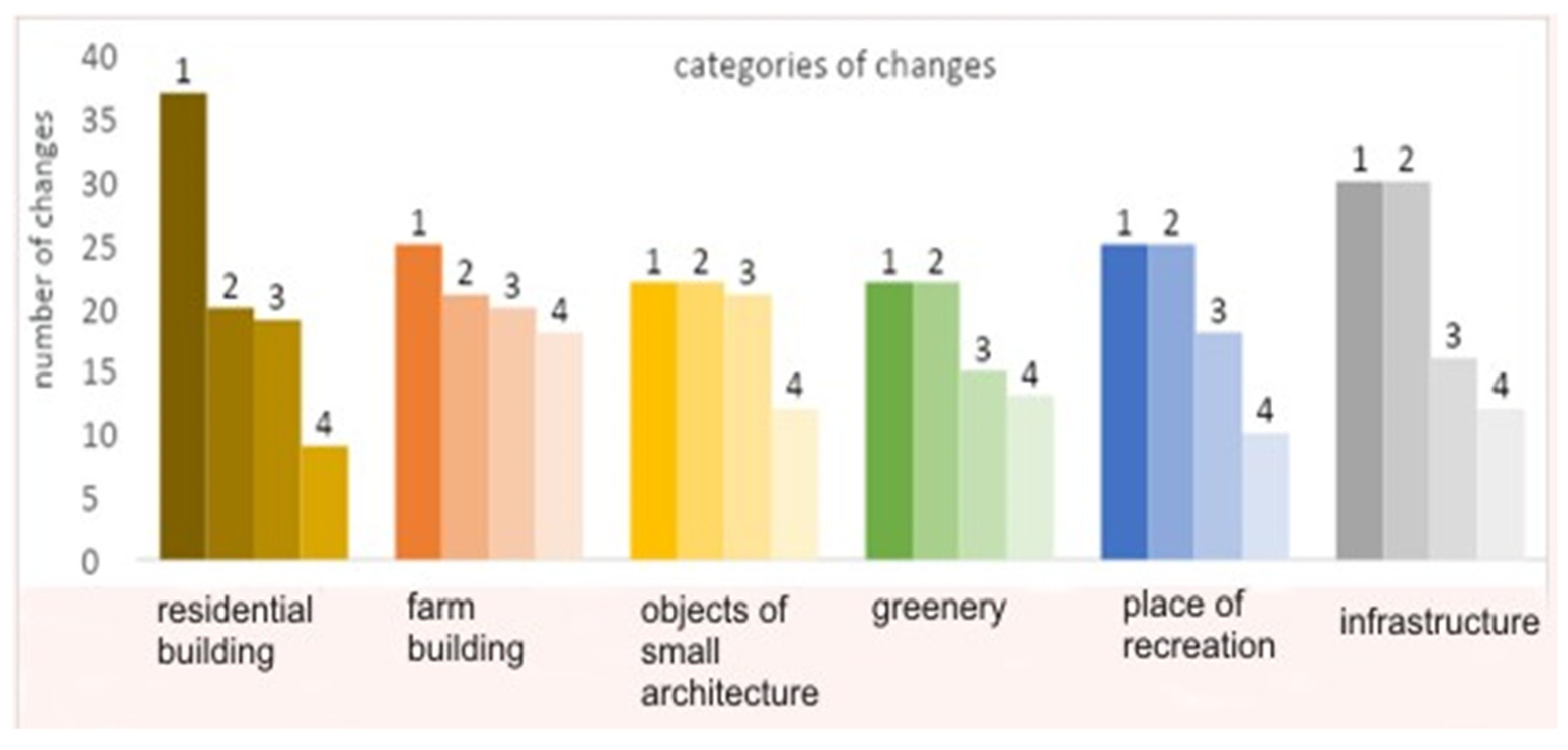
4.3. The Extent of Changes in the Farm When Changing Its Function from an Agricultural to Agritourism
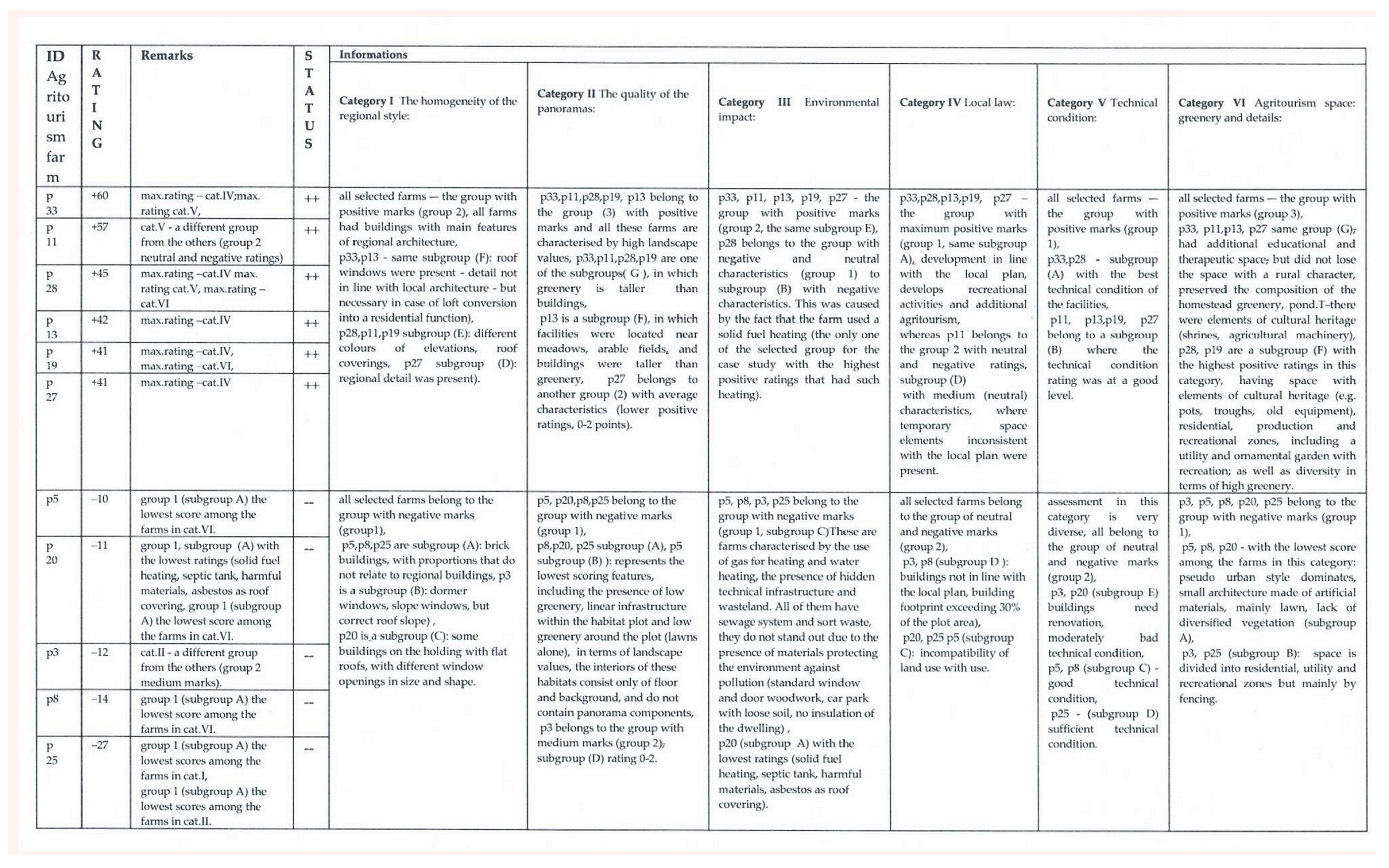
4.4. Assessment Categories for Agritourism Farms
4.5. Assessment Data Interpretation Method
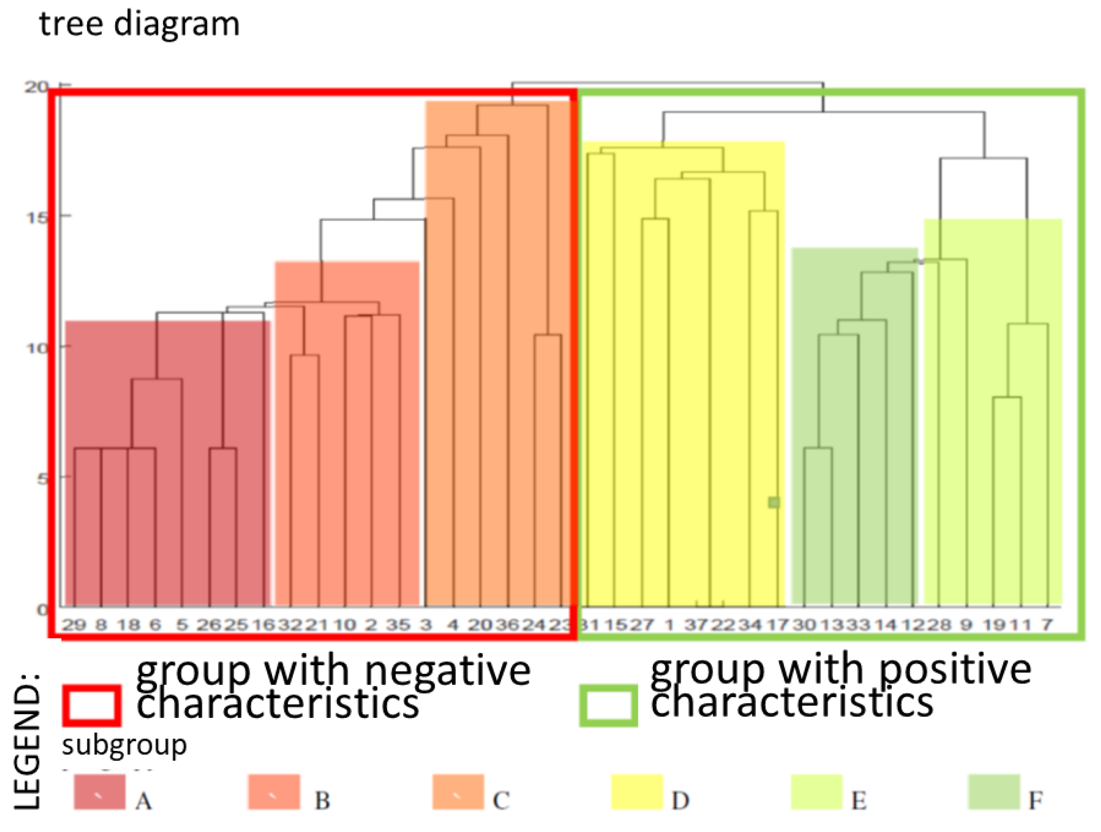
4.6. Cluster Analysis Furthest Neighbour (Complete Linkage), the Maximum Distance
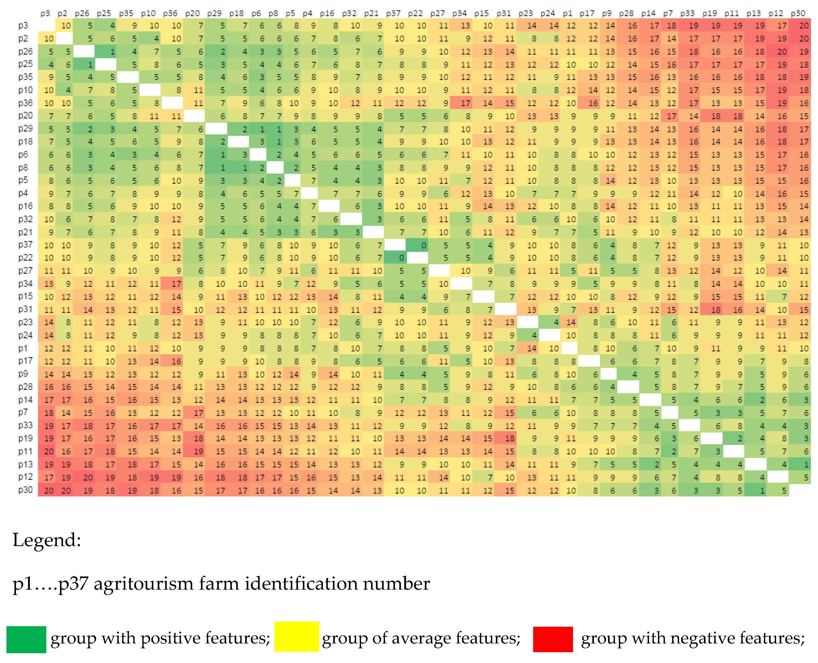
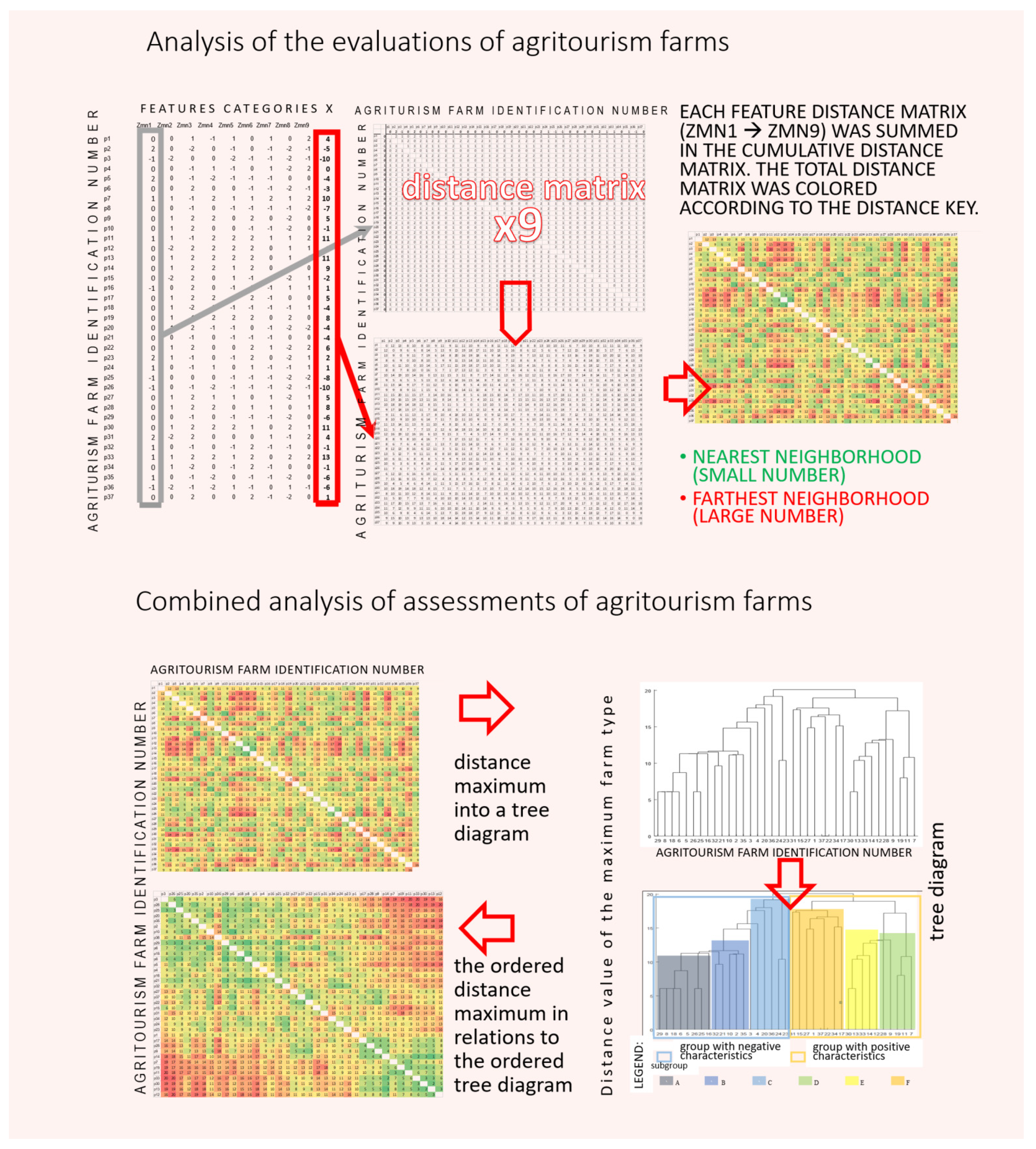
4.7. Methodology for Analysing Characteristic Data of Agritourism Farms
- The farm (pn) assessed for the characteristics (Zmnx) of the I-VI category;
- A distance matrix was created from each feature (Zmnx) and added to the distance matrix of the respective category (I–VI);
- The distance matrix, for categories I–VI, is colored accordingly:
- (a)
- Green—the nearest neighbor
- (b)
- Red—the furthest neighbor
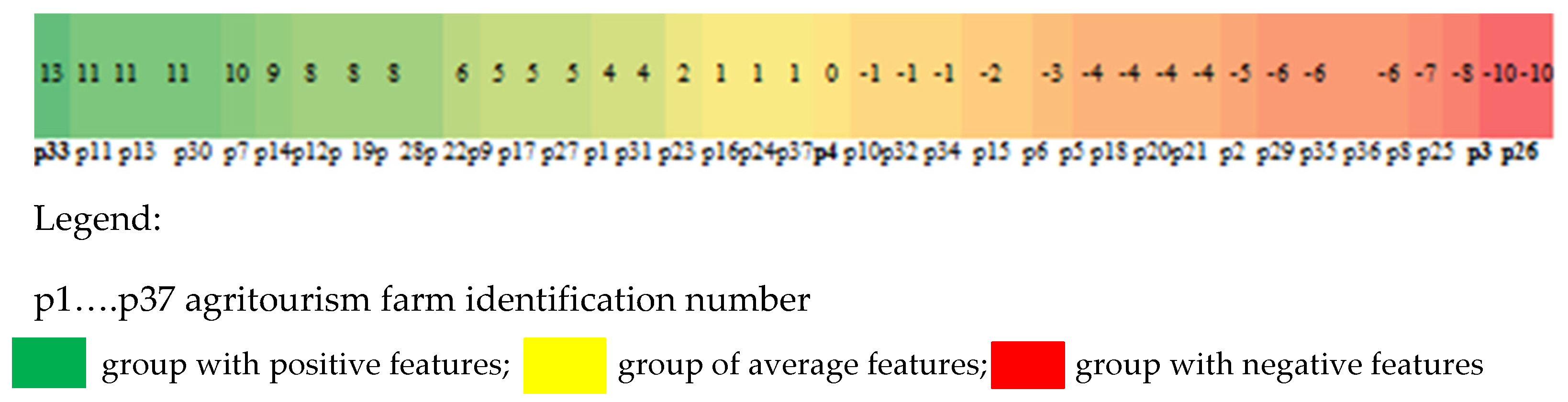
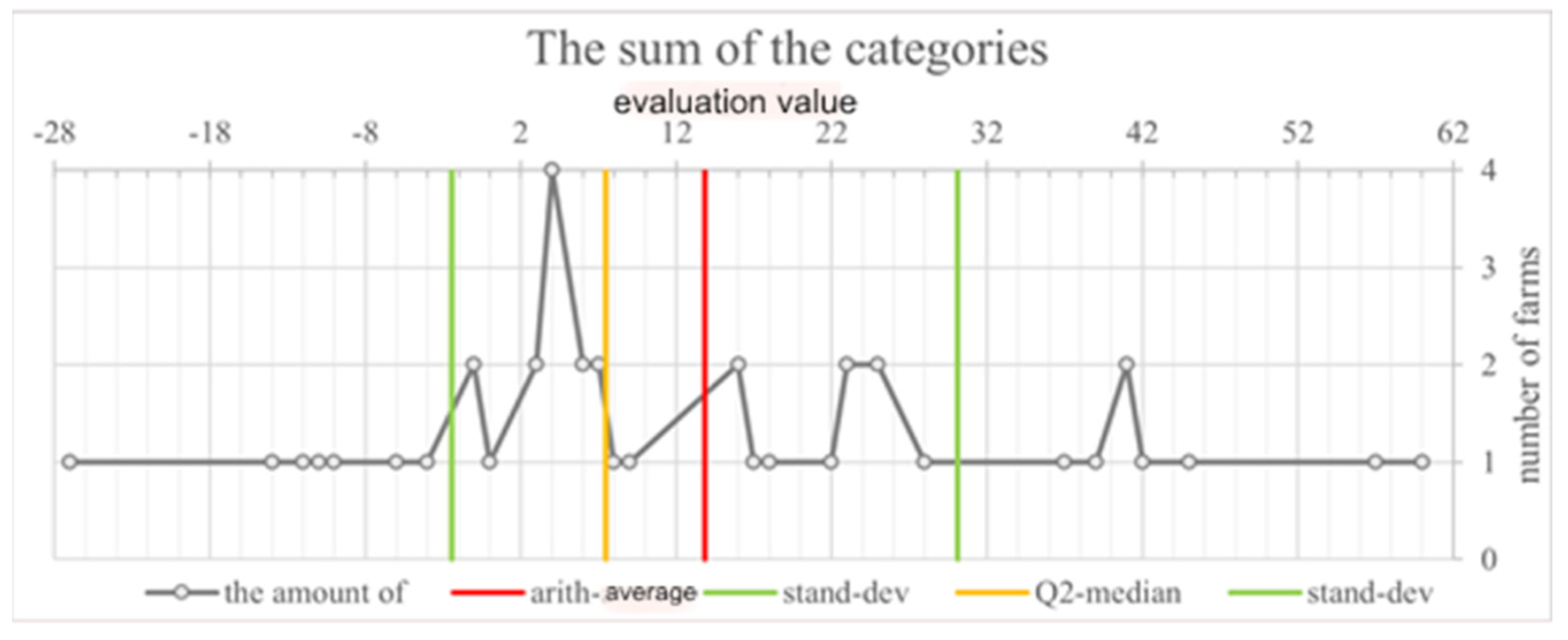
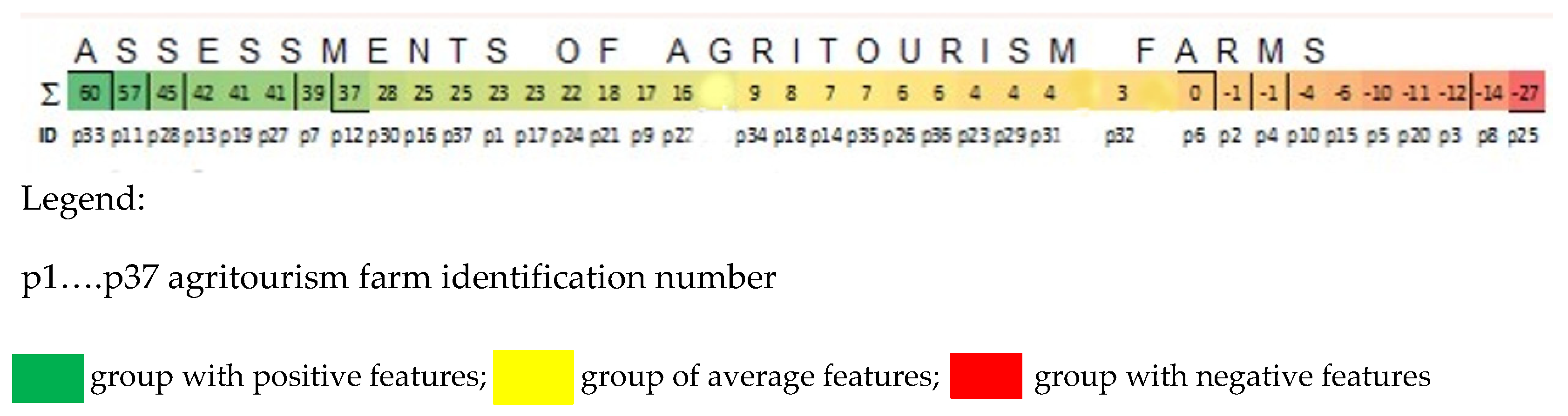
5. Results and Discussion
6. Conclusions
- I, II and VI categories referring to the research sample in terms of their influence on the visual perception of the rural landscape in the region of Kłodzko, show the greatest variation;
- III, IV and V category do not make a significant difference to the characteristics of the test subjects in terms of the visual perception of the unit in the rural landscape; but they are important in terms of further development and environmental impact minimization;
- The owners of agritourism farms comply with the law, as they receive positive ratings in category IV;
- The study has indicated a correlation between the I and VI category, which confirms the differentiation of parametric values for these categories.
Author Contributions
Funding
Institutional Review Board Statement
Informed Consent Statement
Data Availability Statement
Acknowledgments
Conflicts of Interest
Appendix A


References
- Sznajder, M.; Przezbórska, L. Agroturystyka; Polskie Wydawnictwo Ekonomiczne: Warszawa, Poland, 2006; Available online: https://0-scholar-google-com.brum.beds.ac.uk/citations?view_op=view_citation&hl=pl&user=dGYXVoIAAAAJ&citation_for_view=dGYXVoIAAAAJ:u-x6o8ySG0sC (accessed on 15 March 2018).
- Balińska, A.; Zawadka, J. Znaczenie agroturystyki w rozwoju obszarów wiejskich/The importance of agritourism in rural development. Zeszy. Naukowe Szk. Gł. Gospod. Wiej. Ekon. Organ. Gospod. Żywn. 2013, 102, 127–143. [Google Scholar]
- Roman, M.; Roman, M.; Prus, P. Innovations in agritourism: Evidence from a region in Poland. Sustainability 2020, 12, 4858. [Google Scholar] [CrossRef]
- Drzewiecki, M. Wiejska Przestrzeń Rekreacyjna, Instytut Turystyki; ECEAT Europejskie Centrum Rolnictwa Ekologicznego i Turystyki—ECEAT: Warszawa, Poland, 1997; pp. 152–153. Available online: http://www.eceat.agroturystyka.pl (accessed on 16 March 2018).
- Koreleski, K. Ochrona i kształtowanie terenów rolniczych w systemie kreowania krajobrazu wiejskiego/Protection and shaping of agricultural areas within the system of rural landscape creation. Infrastrukt. Ekol. Teren. Wiej. 2009, 4, 5–20. [Google Scholar]
- Podolska, A.; Niedźwiecka-Filipiak, I. Wpływ wsi tematycznych na wizualne aspekty krajobrazu wsi/Influence of thematic villages on visual aspects of rural landscape. Prace Kom. Kraj. Kulturowego 2016, 34, 117–135. [Google Scholar]
- Niedźwiecka, I.; Gubański, J.; Bocheńska-Skałecka, A.; Kuriata, A. Rola wyróżników krajobrazu wiejskiego w procesie rewitalizacji wsi/The role of rural landscape distinguishing features in the process of rural revitalization. Stud. Obsz. Wiej. 2019, 49, 93–108. [Google Scholar] [CrossRef]
- Górka, A. Threats to rural landscape and its protection in Poland. Environments 2018, 5, 109. [Google Scholar] [CrossRef] [Green Version]
- Trocka-Leszczyńska, E.; Nykiel, J. Możliwości zachowania cech architektury regionalnej w Kotlinie Kłodzkiej/The possibilities of preserving the characteristics of the vernacular architecture in the Kłodzko Valley. Mater. Bud. 2015, 11, 169–171. [Google Scholar] [CrossRef]
- Jędrysiak, T. Wiejska Turystyka Kulturowa; Polskie Wydawnictwo Ekonomiczne: Warszawa, Poland, 2010; ISBN 978-83-208-1844-4. [Google Scholar]
- Szwichtenberg, A. Pojmowanie turystyki wiejskiej w Polsce i na świecie/The perception of rural tourism in Poland and the word. Turysm 1998, t.8.z.1, 29–37. [Google Scholar] [CrossRef]
- Herbst, K. Agroturystyka. Materiały Szkoleniowe; Ministerstwo Gospodarki, Departament Turystyki: Warszawa, Poland, 2002. [Google Scholar]
- Maruszewska, I. Sentimentality versus transformation of the historical traditional rural landscape (case study: The landscape of dutch law settlement in Poland). Quaest. Geogr. 2019, 38, 53–70. [Google Scholar] [CrossRef] [Green Version]
- Ciolac, R.; Csosz, I.; Balan, I.; Dincu, A.M. Research regarding the impact of rural tourism forms on the rural area. Sci. Pap. Anim. Sci. Biotechnol. 2011, 44, 476–478. [Google Scholar]
- Daw, T.M.; Hicks, C.; Brown, K.; Chaigneau, T.; Januchowski-Hartley, F.; Cheung, W.; Rosendo, S.; Crona, B.; Coulthard, S.; Sandbrook, C.; et al. Elasticity in ecosystem services: Exploring the variable relationship between ecosystems and human well-being. Ecol. Soc. 2016, 21, 1. [Google Scholar] [CrossRef]
- Hausmann, A.; Slotow, R.; Burns, J.; Minin, E.D. The ecosystem service of sense of place: Benefits for human well-being and biodiversity conservation. Environ. Conserv. 2016, 43, 117–127. [Google Scholar] [CrossRef] [Green Version]
- Strijker, D.; Bosworth, G.; Bouter, G. Research methods in rural studies: Qualitative, quantitative and mixed methods. J. Rural Stud. 2020, 78, 262–270. [Google Scholar] [CrossRef]
- Krzysztofik, M. Problematyka prawna pojęcia obszaru wiejskiego/Legal issue of the definition of the rural area. Stud. Iurid. Lub. 2017, 26, 299–314. [Google Scholar] [CrossRef] [Green Version]
- Bański, J. Geografia Polskiej Wsi; Polskie Wydawnictwo Ekonomiczne: Warszawa, Poland, 2006. [Google Scholar]
- Wiśniewska, M. Osadnictwo Wiejskie; Oficyna Wydawnicza Politechniki Warszawskiej: Warszawa, Poland, 2007. [Google Scholar]
- Włodarczyk-Marciniak, R.; Frankiewicz, P.; Krauze, K. Socio-cultural valuation of Polish agricultural landscape components by farmers and its consequences. J. Rural Stud. 2020, 74, 190–200. [Google Scholar] [CrossRef]
- Tschirschnitz, H. Place of agritourism in a balanced development of rural areas. Ecol. Quest. 2011, 15, 77–80. [Google Scholar] [CrossRef] [Green Version]
- Cymerman, R.; Falkowski, J.; Hopfer, A. Krajobrazy Wiejskie (Klasyfikacja i Kształtowanie); Wydawnictwo Art: Olsztyn, Poland, 1992. [Google Scholar]
- Bogdanowski, J. Projekt standardowego opracowania problematyki ochrony wartości kulturowego krajobrazu i środowiska w studium do planu i miejscowym planie zagospodarowania przestrzennego/The protection of values of cultural landscape and environment to be included in the management plan and local development plan of a commune. Landscapes 1998, IV, 13–14. [Google Scholar]
- Konopka, M.; Pustoła-Kozłowska, E.; Matyaszczyk, D. Każde Miejsce Opowiada Swoja Historię Czyli Rzecz o Dziedzictwie Wiejskim; Fundacja Fundusz Współpracy: Poznań, Poland, 2001; ISBN 83-87116-73-4. [Google Scholar]
- Raszeja, E. Ochrona Krajobrazu w Procesie Przekształceń Obszarów Wiejskich; Wydawnictwo Uniwersytetu Przyrodniczego w Poznaniu: Poznań, Poland, 2013; pp. 147–207. ISBN 978-83-7160-699-1. [Google Scholar]
- Jaszczak, A.; Hernik, J. Potencjał krajobrazów kulturowych podstawą kreacji przestrzeni rekreacyjnej. Infrastruktura i ekologia terenów wiejskich/Potential of cultural landscapes in the creation of tourist and recreation areas. Infrastrukt. Ekol. Teren. Wiej. 2012, 3/II, 91–104. [Google Scholar]
- Szczepańska, M.; Wilkaniec, A. Outdoor advertising in the cultural landscape of rural areas attractive in tourist terms. Stud. Obsz. Wiej. 2016, 43, 87–100. [Google Scholar] [CrossRef] [Green Version]
- Podolska, A. Dolnośląskie wsie tematyczne—Miejsce edukacji i zabawy. Stud. Obsz. Wiej. 2019, 54, 53–68. [Google Scholar] [CrossRef] [Green Version]
- Jeangros, B.; Thomet, P. Multi-functionality of grassland system in Switzerland. Land Use Syst. Grassl. Dom. Reg. 2004, 7, 11–23. [Google Scholar]
- Ciolac, R.; Rujescu, C.; Constantinescu, S.; Adamov, T.; Dragoi, M.C.; Lile, R. Management of a tourist village establishment in mountainous area through analysis of costs and incomes. Sustainability 2017, 9, 875. [Google Scholar] [CrossRef] [Green Version]
- Abellán, F.C.; Martínez, C.G. Landscape and tourism as tools for local development in mid-mountain rural areas in the southeast of Spain (Castilla-La Mancha). Land 2021, 10, 221. [Google Scholar] [CrossRef]
- Kostrowicki, J. Obszary wiejskie jako przestrzeń wielofunkcyjna. Zagadnienia badawcze i planistyczne. Prz. Geogr. 1976, 48, 601–611. [Google Scholar]
- Kłodziński, M. Wielofunkcyjny Rozwój Terenów Wiejskich w Polsce i w Krajach Unii Europejskiej; SGGW: Warszawa, Poland, 1996. [Google Scholar]
- Heffner, K. Transformacja układów osadniczych wsi a wielofunkcyjny rozwój obszarów wiejskich. In Wieś i Rolnictwo na Przełomie Wieków; Rosner, A., Bukraba-Rylska, I., Eds.; PAN IRWiR: Warszawa, Poland, 2001; ISBN 83-85369-51-1. [Google Scholar]
- Primdahl, J.; Swaffield, S. Globalisation and Agricultural Landscapes: Change Patterns and Policy Trends in Developed Countries (Cambridge Studies in Landscape Ecology); Cambridge University Press: Cambridge, UK, 2012; pp. 271–275. [Google Scholar] [CrossRef]
- Bórawski, P. (Ed.) Multifunctional Development of Rural Areas: International Experience; Wydawnictwo Wyższej Szkoły Ekonomiczno-Społecznej w Ostrołęce: Ostrołęka, Poland, 2012; ISBN 978-83-929620-7-6. [Google Scholar] [CrossRef]
- Bjørkhaug, H.; Knickel, K. Rethinking the links between farm modernisation, rural development and resilience. J. Rural Stud. 2018, 59, 194–196. [Google Scholar] [CrossRef]
- Pijanowski, Z. Rozwój obszarów wiejskich w Polsce a dyscyplina naukowa “kształtowanie środowiska”/Development of rural areas in Poland and a scientific discipline “environmental development”. Prz. Nauk. Inż. Kształt. Śr. 2006, 15, 5–18. [Google Scholar]
- Bajerowski, T.; Biłozar, A.; Cieślak, I.; Senetra, A.; Szczepańska, A. Ocena i Wycena Krajobrazu; Wyd. Educaterra: Olsztyn, Poland, 2007. [Google Scholar]
- Richling, A.; Solon, J. Ekologia Krajobrazu; PWN: Warszawa, Poland, 2011; pp. 199–216. ISBN 9788301167332. [Google Scholar]
- Lis, A.; Burdziński, J.; Gubański, J.; Walter, E.; Bocheńska-Skałecka, A. Aktywizacja Przestrzeni Publicznych w Mieście—Ocena Potencjału Miejsc; Wyd. Uniwersytetu Przyrodniczego we Wrocławiu: Wrocław, Poland, 2014; pp. 62–66. ISBN 978-83-7717-193-6. [Google Scholar]
- Butler, A.; Berglund, U. Landscape character assessment as an approach to understanding public interests within the European landscape convention. Landsc. Res. 2014, 39, 219–236. [Google Scholar] [CrossRef] [Green Version]
- Tudor, C. An Approach to Landscape Character Assessment, Natural England. 2014. Available online: www.gov.uk/natural-england (accessed on 10 March 2019).
- Rippon, S. Historic landscape character and sense of place. Landsc. Res. 2013, 38, 179–202. [Google Scholar] [CrossRef]
- Battis-Schinkera, E.; Al-Alawib, S.; Knippschilda, R.; Gmurc, K.; Książek, S.; Kukuła, M.; Belof, M. Towards quality of life indicators for historic urban landscapes—Insight into a German-Polish research project. Environ. Sustain. Indic. 2021, 10, 100094. [Google Scholar] [CrossRef]
- Owen, S. From village design statements to parish plans: Some pointers towards community decision making in the planning system in England. Plan. Pract. Res. 2002, 17, 81–89. [Google Scholar] [CrossRef]
- Kalidindi, N.; Le, A.; Picone, J.; Zheng, L.; Yaqin, H.; Rudis, V. Scenic beauty estimation of forestry images. In Proceedings of the IEEE SOUTHEASTCON’97. ‘Engineering the New Century’, Blacksburg, VA, USA, 12–14 April 1997. [Google Scholar] [CrossRef]
- Myga-Piątek, U. Kryteria i metody oceny krajobrazu kulturowego w procesie planowania przestrzennego na tle obowiązujących procedur. In Waloryzacja Środowiska Przyrodniczego w Planowaniu Przestrzennym; Kistowski, M., Korwel-Lejkowska, B., Eds.; Wyd. Uniwersytet Gdański: Gdańsk-Warszawa, Poland, 2007; Volume 19, pp. 101–110. ISBN 978-83-7531-005-4. Available online: http://www.paek.ukw.edu.pl/wydaw/vol19/myga_piatek_2007.pdf (accessed on 19 April 2022).
- Niedźwiecka-Filipiak, I. Proponowana metoda sektorowej analizy wnętrz krajobrazowych jako integralna część opracowań dla programu Odnowy Wsi/Proposed method of sector analyses of landscape interiors as an integral part of elaboration for village renewal program. Architekt. Kraj. 2005, 3–4, 11–17. [Google Scholar]
- Chmielewski, T.J. Systemy Krajobrazowe: Struktura, Funkcjonowanie, Planowanie; Wydawnictwo Naukowe PWN: Warszawa, Poland, 2012; ISBN 9788301168780. [Google Scholar]
- Drzewiecki, M. Standard wypoczynku we wsiach letniskowych. Acta Univ. Lodz. Turyzm 1987, 3. Available online: https://www.infona.pl/resource/bwmeta1.element.hdl_11089_23665 (accessed on 10 January 2019).
- BDL. Bank Danych Lokalnych, Wrocław, Dolnośląskie, Poland. Available online: https://bdl.stat.gov.pl/BDL/start (accessed on 15 June 2020).
- Strategia Rozwoju Powiatu Kłodzkiego na Lata 2008–2015. Starostwo Powiatowe w Kłodzku: Kłodzko, Poland, 2007. Available online: https://powiat.klodzko.pl/download//193/strategia-powiatu-klodzkiego.pdf (accessed on 11 March 2018).
- Zarys Opracowania Dotyczący Rozwoju Obszarów Wiejskich i Rolnictwa Województwa Dolnośląskiego do 2030 r; Wrocław, Poland. 2017. Available online: https://www.dodr.pl/informacje/strategia-wies-i-rolnictwo (accessed on 25 May 2017).
- Biczkowski, M.; Biczkowska, M. Impact of the EU funds on the diversification of economic activity (of farms) and their role in multi-functional development of rural areas. Stud. Obsz. Wiej. 2016, 43, 23–44. [Google Scholar] [CrossRef] [Green Version]
- Przezbórska-Skobiej, L.; Sobotka, S. Propozycja delimitacji regionów agroturystycznych w Polsce. Wieś Rol. 2016, 171, 173–197. [Google Scholar] [CrossRef]
- Bocheńska-Skałecka, A. Popularyzacja zasad kształtowania współczesnej architektury sudeckiej na obszarach o szczególnych walorach krajobrazowych i uzdrowiskowych—Jako zabudowy wpisującej się w krajobraz. In Projektowanie Architektury na Terenach o Szczególnych Walorach Krajobrazowych i Uzdrowiskowych; Hanna, J., Ed.; Oficyna Wydawnicza Politechniki Wrocławskiej: Wrocław, Poland, 2012; pp. 89–95. ISBN 978-83-7493-694-1. [Google Scholar]
- Trocka-Leszczyńska, E. The contemporary rural landscape in the South-Western Region of Poland (Sudeten Region)—A search for spatial order. In Proceedings of the International Conference of Design, User Experience, and Usability, DUXU 2014: Design, User Experience, and Usability. User Experience Design for Everyday Life Applications and Services, Heraklion, Crete, Greece, 22–27 June 2014; pp. 470–481. [Google Scholar] [CrossRef]
- Torquati, B.; Tempesta, T.; Vecchiato, D.; Venanzi, S.; Paffarini, C. The value of traditional rural landscape and nature protected areas in tourism demand: A study on agritourists’ preferences. Landsc. Online 2017, 53, 1–18. [Google Scholar] [CrossRef]
- Niedźwiecka-Filipiak, I.; Potyrała, J. Infrastruktura jako czynnik warunkujący rozwój agroturystyki. In Zeszyty Naukowe AR we Wrocławiu, Melioracje XLII; Wydawnictwo Akademii Rolniczej we Wrocławiu: Wrocław, Poland, 1996; Volume 19, pp. 189–194. [Google Scholar]
- Ostrowska-Dudys, M. Wpływ Gospodarstw Agroturystycznych na Kształtowanie Obszarów Wiejskich w Regionie Kłodzkim (Influence of Agritourism Farms on Shaping Rural Areas in the Kłodzko Region). Doctor’s Thesis, Wrocław University of Environmental and Life Sciences, Wrocław, Poland, 2019. Available online: https://bazawiedzy.upwr.edu.pl/info/phd/UPWrbb9098948967478dbed9955b83c1abec/ (accessed on 19 November 2019).
- Mazurski, K.R. Environmental problems in the Sudetes, Poland. GeoJournal 1998, 46, 271–277. [Google Scholar] [CrossRef]
- Ostrowska-Dudys, M.; Bocheńska-Skałecka, A.; Hutnik, E. Popularyzacja zasad kompozycji krajobrazu przy użyciu rysunku architektoniczno-krajobrazowego-edukacja społeczna. In Forum Architektury Krajobrazu. Praktyka Zawodowa. Badania Naukowe. Dydaktyka; Ozimek, A., Sykty, I., Eds.; Wyd. Politechniki Krakowskiej: Kraków, Poland, 2021; pp. 53–70. [Google Scholar]
- StatSoft. Elektroniczny Podręcznik Statystyki PL. Analiza skupień, Hierarchiczne drzewo; Kraków, Poland. Available online: http://www.statsoft.pl/textbook/stathome.html (accessed on 15 April 2018).
- Marek, T. Analiza Skupień w Badaniach Empirycznych. Metody SAHN; PWN: Warszawa, Poland, 1989. [Google Scholar]
- Kutkowska, B. Podstawy Rozwoju Agroturystyki ze Szczególnym Uwzględnieniem Agroturystyki na Dolnym Śląsku; Wydaw. Akademii Rolniczej we Wrocławiu: Wrocław, Poland, 2003. [Google Scholar]
- Pogodziński, Z. Planowanie Przestrzenne Terenów Wiejskich; PWN: Warszawa, Poland, 1977. [Google Scholar]
- Alcindor, M.; Delton, J.; Alcindor-Huelva, P. Heritage places and the place attachment of adolescents: The case of the Castelo of Vila Nova de Cerveira (Portugal). J. Rural Stud. 2021, 88, 410–421. [Google Scholar] [CrossRef]


| Category | Feature Group | Feature (Rating) |
|---|---|---|
| Category I The homogeneity of the regional style | 1.Roof angle: | 55° ≥ x ≥ 45° (+2)FAR; 55° ≥ x ≥ 45°, dormer windows (+1)FAR; 55° ≥ x ≥ 45°, roof windows (0); 30° ≥ x or flat roof (−1); 30° ≥ x or flat roof, dormer windows (−2). |
| 2. Roof material: | shingle/slate (+2)FAR; ceramic, concrete, metal roofing tiles, roofing felt (imitating shingle/slate) (+1)FAR; ceramic, concrete, metal roofing tiles, roofing felt (not imitating shingle or slate) (0); papa / thatch (−1); eternite (−2). | |
| 3. Roof color: | dark brown, graphite (+2)FAR; brown (+1); light brown/black (0); red/orange (−1); blue/green/other (−2). | |
| 4. Roof shape: | pitched 2/3 of the height of the building (+2)FAR; pitched higher than the walls (+1); pitched symmetrical (0); pitched, broken (asymmetrical) (−1); multi-hipped/flat (−2). | |
| 5. Building material: | first floor-wooden, ground floor-brick (+2)FAR; first floor painted, ground floor plastered (+1); white plastered (0); plaster other than white or panels (−1); other materials glass/slate/mosaic (−2). | |
| 6. Shape residential building: | permissible dimensions: h = approx. 10m (h farmhouse = 8, h garage = 6) (+2)FAR; dimensions in the ratio 1 wall: 2 roof (+1)FAR; dimensions in the ratio length: width 2:1 (0); dimensions in unacceptable proportions (−1); exceeding the permissible dimensions (−2). | |
| 7.Residential building construction: | wooden (residential function)-brick (livestock f.) (+2)FAR; brick (residential function)—wood (livestock function) (+1); mixed (function does not depend on construction) (0); brick built as a whole (−1); entirely wooden (residential and utilitarian) (−2). | |
| 8.Building details: | eaves-wooden carved(+2)FAR; arcades, balcony galleries/boarded gables (+1)FAR; white window and door bands(0);window bands other than white (−1); windows without bands, various shapes (−2). | |
| 9. Types of buildings in the yard: | combined building with residential and livestock functions (+2)FAR; composite building with a residential function (+1); non-segregated buildings (0); a residential building and a non-agricultural building (e.g., garage, shed) (−1); only residential building (−2). | |
| Category II The quality of the panoramas | 1. Transparency of space: | multiplanarity of the view (+2); no infrastructure (open view) (+1); vertical point infrastructure (0); overhead linear infrastructure (−1); infrastructure obstructing the view (−2). |
| 2. Landscape elements of the interior: | background, walls, floor, partitions—visible, (more than 4 plans) (+2); background, walls, floor—visible, partitions on walls (+1); background, walls, floor—visible (0); floor—visible, background—visible (−1); floor—visible, background—covered (−2). | |
| 3. The ratio of greenery to buildings: | greenery higher than buildings(+2); greenery and buildings of equal height (+1); buildings higher than greenery (0); high buildings, low greenery (−1); high buildings, no greenery (−2). | |
| 4. Accompanying greenery characteristic of a traditional village: | solitary/large trees/shrine/cross (+2); avenue/row (+1); low vegetation, e.g., crops, meadow (0); low grassy vegetation (−1); no greenery (−2). | |
| 5. Location of agritourism in relation to other buildings in the village: | compact—objects on one side (+2); compact—buildings situated on both sides (+1); solitary (0); loosely built-up area (−1); in the second line of development (−2). | |
| 6. Landscape values: | on a viewing axis or vantage point (+2); the exposition foreground (+1); panorama components present (0); no panorama components (−1); no exposure (−2). | |
| Category III Environmental impact | 1. Source of energy: | heat pump, solar collectors (+2); co-generation furnace (+1); mains heating (0); solid fuel cooker (−1); fireplace (as the only one for heating) (−2). |
| 2. Eco-friendliness of the materials used: | environmental protection materials (e.g., insulation, joinery) (+2); filtering materials car park with protected floor (+1); lack of environmental protection materials (car park with substrate, no insulation, standard window joinery) (0); lack of environmental protection materials (e.g., car park surface, poor quality window joinery, slurry boards, cavities in plaster “thermal bridges”) (−1); harmful material, e.g., asbestos (−2). | |
| 3. Waste management: | compost, segregation, rainwater harvesting (+2); infiltration plant (+1); sewage treatment plant, waste separation (0); septic tank, no waste separation (−1); no sealed tank/landfill (−2). | |
| 4. Farm status: | certified organic (+2); organic without certification (e.g., transitional period) (+1); conventional farm (0); intensive or monoculture holding (−1); large-scale enterprise (−2). | |
| 5. Land infrastructure: | lack of visible elements. technical infrastructure (+2); concealed infrastructure elements (+1); wells (0); poles, wells (−1); trafostacja (−2). | |
| Category IV Local law | 1.Use of the area.: | as intended and for an additional purpose (development of activities) (+2); as intended and used for additional purpose (+1); as intended (0); compatible with the local plan, but location of incompatible functions (−1); inconsistent with the local plan (−2). |
| 2. Building conditions (administrative decision, guidelines: | massing and floors in accordance with the guidelines (+2); development with a number of floors according to the guidelines (+1); development consistent with the function (0); development not in line with guidelines (solid) (−1); buildings with inconsistent number of floors, poor distribution of window surfaces, façade materials with guidelines (−2). | |
| 3. Land cover (degree of development of biologically active land): | additional biologically active surface (e.g., on a wall or roof) (+2); less than 30% of the plot area built up or permeable surfaces (+1); built-up area of approx. 30% of the plot area (0); developed area in more than 30% or impermeable area (−1); built-up area of more than 50% of the plot (−2). | |
| 4. Recreational suitability by way of use: | recreation on landscaped grounds (linked to the surroundings) (+2); services related to recreation (cultural, sports, tourism—ruins) (+1); elements supporting recreation (garden, small architecture, forest) (0); objects indifferent to recreation (housing, wasteland, agricultural land, shop) (–1); objects interfering with recreation (industry, warehouses, transport, railway) (−2). | |
| 5. Recreational suitability by way of use in accordance with the local land development plan: | permanent (investment in agro-tourism) (+2); residential, amenity greenery (barbecue, playground) (+1); temporary or mixed (including those not in conformity with the plan) (0); incompatible with the function (−1); undeveloped (no purpose) (−2). | |
| Category V Technical condition | 1. Technical condition of the roof: | very good (new/renovated) (+2); good (+1); average (requires refurbishment/maintenance) (0); sufficient (requires renovation) (−1); bad (likely to collapse) (−2). |
| 2. Technical condition of the facade: | very good (new/renovated) (+2); good (+1); average (requires refurbishment/maintenance) (0); sufficient (requires renovation) (−1); bad (likely to collapse) (−2). | |
| 3. Technical condition of the farm building and another: | very good (new/renovated) (+2); good (+1); average (requires refurbishment/maintenance) (0); sufficient (requires renovation) (−1); bad (likely to collapse) (−2). | |
| 4. Technical condition of the infrastructure: | very good (new/renovated) (+2); good (+1); average (requires refurbishment/maintenance) (0); sufficient (requires renovation) (−1); bad (likely to collapse) (−2). | |
| Category VI Agritourism space: greenery and details | 1. Functional zones: | residential, manufacturing, recreational, accessory (e.g., educational, therapeutic) (+2); residential, production, recreational (+1); residential, production (0); residential, utilitarian (−1); residential (−2). |
| 2. The presence of greenery: | ornamental, recreational, amenity garden (+2); ornamental, amenity garden (+1); ornamental garden (0); no garden (only green areas) (−1); no garden and other greenery (−2). | |
| 3. Garden style—vegetation: | in keeping with the region and style, rural (+2); in keeping with the region or style (+1) rural; not compatible with the style but local (rural) (0); not compatible with the style but region (−1); not compatible with the region and not rural (−2). | |
| 4. Garden style—small architecture and details: | regional materials (+2); materials imitating regional character (+1); neutral materials (wood/stone) (0); material not found in the region (−1); distinctive material (plastic/metal) (−2). | |
| 5. Garden style -nature of coverage: | preserved old composition (numerous plantings) (+2); retained old planting (single) (+1); species compatible with the former layout (0); species incompatible with the former layout (−1); layout incompatible with former layout (modern style, urban development) (−2). | |
| 6. Garden style -coverage variety: | unique natural values (+2); vertical diversity (+1); horizontal diversity (0); no vertical diversity (−1); no horizontal diversity (−2). | |
| 7.Visible cultural heritage: | numerous items of cultural heritage (machinery and former agricultural equipment) (+2); isolated items of cultural heritage (pots and pans, barrels, etc.) (+1); modern agricultural equipment(0);non-agricultural equipment (−1); scrap—non-agricultural items (−2). | |
| 8. Accompanying buildings in the farm: | cultural heritage sites (windmills, watermills, chapels, etc.) (+2); traditional agricultural sites (barns, stables, etc.) (+1); modern agricultural buildings (silos, garages, sheds, shelters, etc.) (0); large-scale buildings (−1); other objects not related to agriculture (wind turbine, mast, chimney, etc.) (−2). | |
| 9. Advertising and informational objects in the farm: | billboards and decoration made of natural materials (+2); advertising from natural materials (+1); no advertising or information elements (0); lettering, graffiti, neon signs, city-like information signs (−1); large advertising, billboards, etc. (−2). |
| Deviation Range | Color | Evaluation |
|---|---|---|
| from (+20) to (+10) high | green | plus rating |
| from (+9) to (+1) average | yellow | average rating |
| 0 lack of | orange | 0 |
| from (−1) to (−x) low | red | minus rating |
| Parameter | Category I | Category II | Category III | Category IV | Category V | Category VI | Sum Categories |
|---|---|---|---|---|---|---|---|
| X (arithmetic average) | 1.025 | 3.075 | 0.775 | 3.35 | 3.65 | 1.975 | 13.85 |
| Q² (median) | 0.5 | 3 | 1 | 3 | 4 | 1 | 7.5 |
| Dx (dominant) | none | 2 | 1 | 2 | 4 | none | 2 |
| Sx (standard deviation) | 5.53 | 2.88 | 2.06 | 2.19 | 1.61 | 6.72 | 16.29 |
| V(x) (coefficient of variation of collective | 539% | 94% | 266% | 65% | 44% | 340% | 118% |
Publisher’s Note: MDPI stays neutral with regard to jurisdictional claims in published maps and institutional affiliations. |
© 2022 by the authors. Licensee MDPI, Basel, Switzerland. This article is an open access article distributed under the terms and conditions of the Creative Commons Attribution (CC BY) license (https://creativecommons.org/licenses/by/4.0/).
Share and Cite
Bocheńska-Skałecka, A.; Ostrowska-Dudys, M.; Hutnik, E.; Jakubowski, W. Parameterization in the Analysis of Changes in the Rural Landscape on the Example of Agritourism Farms in Kłodzko District (Poland). Sustainability 2022, 14, 8026. https://0-doi-org.brum.beds.ac.uk/10.3390/su14138026
Bocheńska-Skałecka A, Ostrowska-Dudys M, Hutnik E, Jakubowski W. Parameterization in the Analysis of Changes in the Rural Landscape on the Example of Agritourism Farms in Kłodzko District (Poland). Sustainability. 2022; 14(13):8026. https://0-doi-org.brum.beds.ac.uk/10.3390/su14138026
Chicago/Turabian StyleBocheńska-Skałecka, Anna, Maria Ostrowska-Dudys, Edward Hutnik, and Wojciech Jakubowski. 2022. "Parameterization in the Analysis of Changes in the Rural Landscape on the Example of Agritourism Farms in Kłodzko District (Poland)" Sustainability 14, no. 13: 8026. https://0-doi-org.brum.beds.ac.uk/10.3390/su14138026