
Soil Moisture Measuring Techniques and Factors Affecting the Moisture Dynamics: A Comprehensive Review
 , , , ,
  ,
, 
Abstract
:1. Introduction
2. Factors Influencing SSM
3. SSM Estimation Techniques
3.1. Direct Techniues
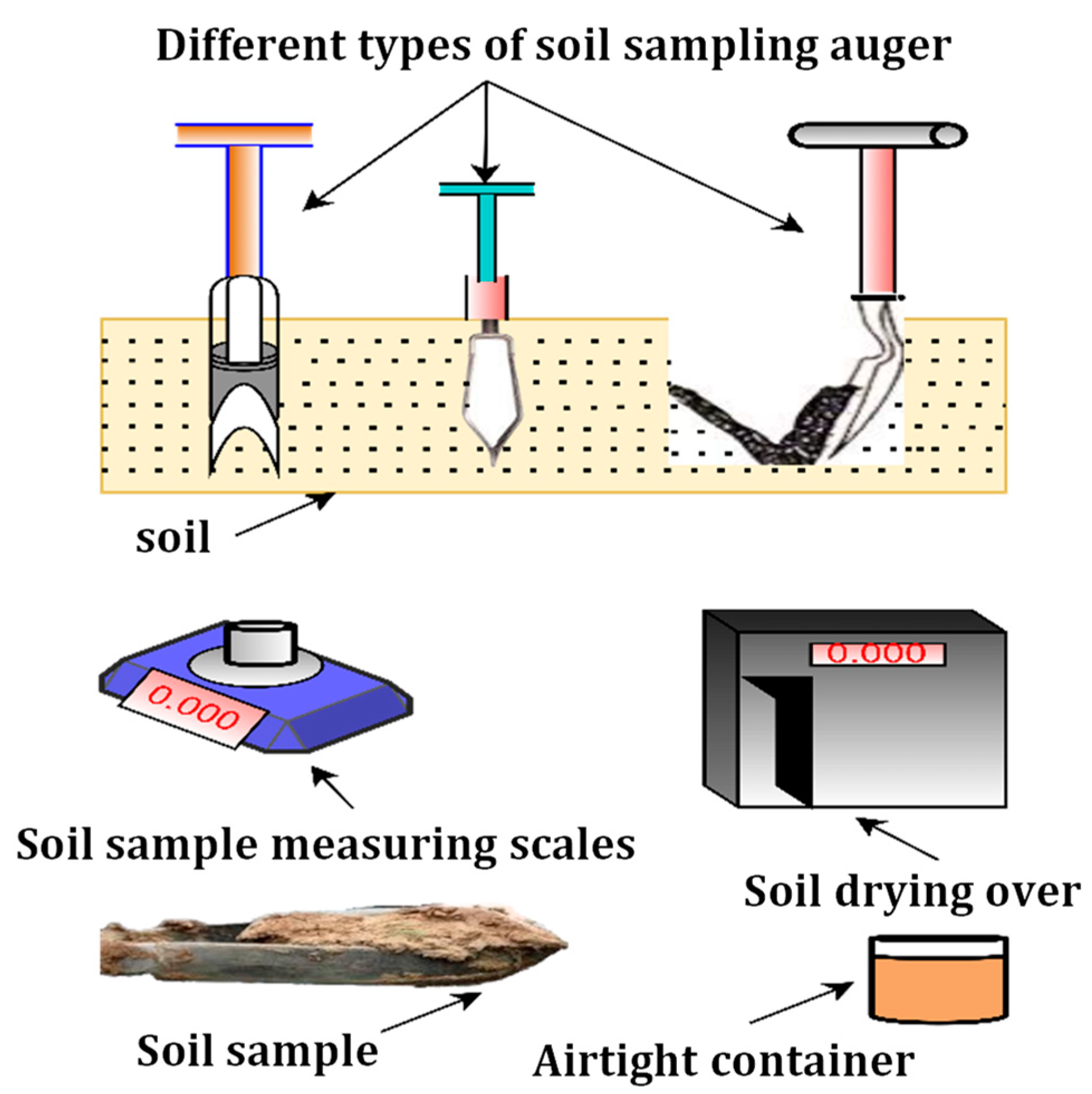
Gravimetric or Oven Drying Technique

| Techniques | Depth | Cost-Effective | Response Time | Spatial Scale | Measured Parameter | Reference |
|---|---|---|---|---|---|---|
| Gravimetric method | Any depth | Cost-effective | 24 h | Confined | Gravimetric moisture content | [58] |
| Neutron probe | <30 cm | Costly | 1–2 min | Confined | Volumetric moisture content | [59] |
| TDR | 30–60 cm | Cost-effective | ~28 s | Confined | Volumetric moisture content | [60] |
| Capacitance and FDR | 100 cm | Costly | Instant | Confined | Volumetric moisture content | [61] |
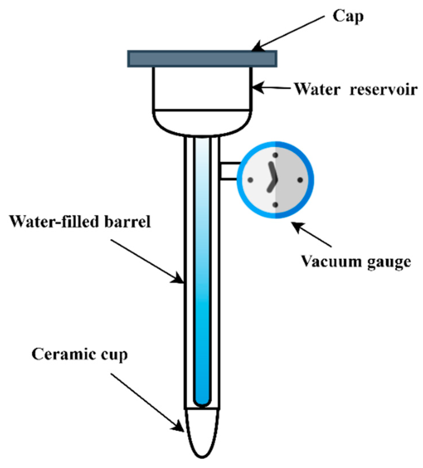
| Tensiometer | 15–60 cm | Cost-effective | 2–3 h | Confined | Soil matric potential | [62] |
| Gamma-ray attenuation | 2.5 cm | Costly | ~60 s | Confined | Volumetric soil moisture content | [62] |
| Capacitance sensor | 20 to 50 cm | Costly | Instant | Confined | Volumetric moisture content | [63] |
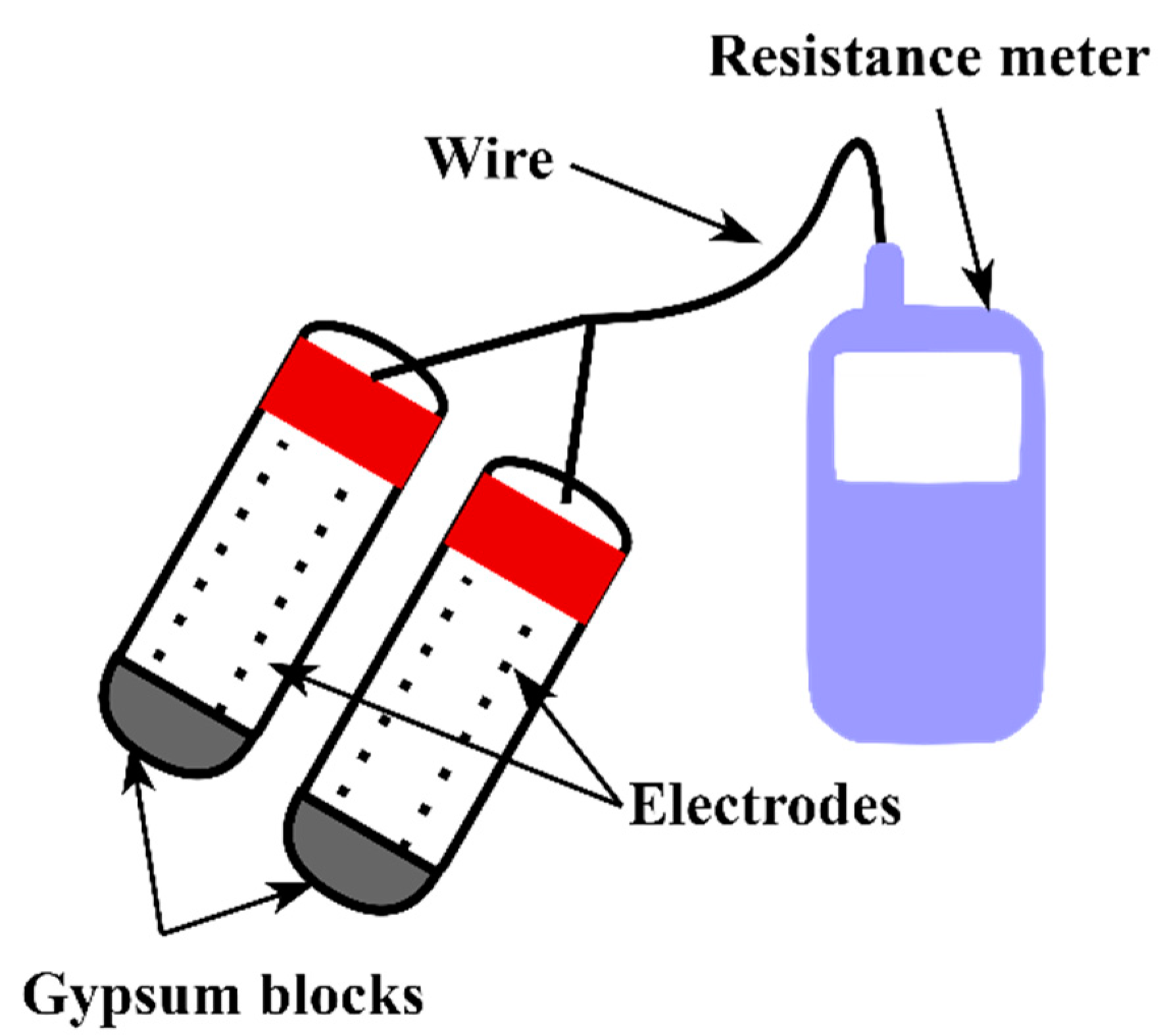
| Gypsum block | 10–30 cm | Cost-effective | 2–3 h | Confined | Soil matric potential | [64] |
| Hygrometric | It depends on the sampling depth | Cost-effective | <3 min | Confined | water potential of soil | [64] |
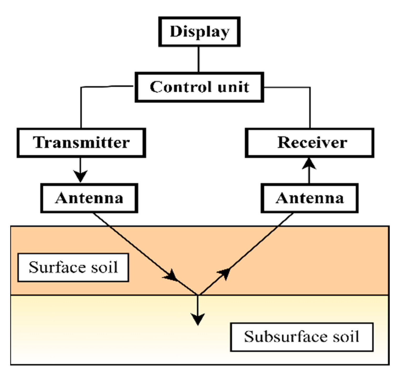
| Ground-penetrating radar | 20 cm to 500 cm | Costly | Instant | Large | Volumetric soil moisture content | [28,65] |
| Cosmic ray | 12 to 76 cm | Costly | Instant | Large | Volumetric soil moisture content | [66] |
3.2. Indirect Techniques
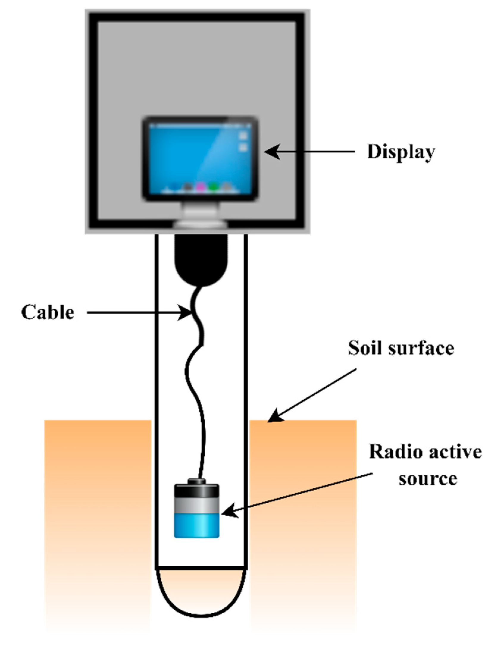
3.2.1. Neutron Scattering Method
| Techniques | Advantage | Limitations | Reference |
|---|---|---|---|
| Gravimetric | Cost-effective, standard, and accurate for determining soil moisture. | Its implementation is labor intensive, time-consuming, destructive, and not easy to use in rocky soil. Use in heterogeneous soil profiles is complicated | [72,73] |
| Neutron dispersing | It is relatively easy, non-destructive, and can measure soil moisture with large volumes at different depths. | Health risks: equipment is costly and needs proper calibration when used in different soil types. The relocation of this device is complicated from one measurement location to another. | [74,75] |
| Gamma attenuation | Non-destructive technique, easy calibration, can provide average moisture content for profile depth, the operation is easy to automate and allows the user to map changes in soil moisture over time. | Expensive, use is problematic, health risks, in the field, has limited applicability, limited to determine the moisture content of sample having a thickness of 2.5 cm, variations in bulk density affect the measurements. | [41,64] |
| Resistive sensor | Cost effective, allows the soil moisture measurement at the same site over time. | Dissolution and degradation of the gypsum block. Each site and measurement range requires individual porous block and measurement interval calibration. The porous block is affected by temperature and salt. It is not suitable in fast drainage soils, like sandy soils. | [76] |
| FDR and Capacitance sensor | Non-destructive equipment’s initial setup is relatively lower than that of TDR; after soil-specific calibration, it provides accurate measurement, and where TDR fails, it can read high salinity levels. | Requires calibration, sensors are expensive, for an extended period, their sustainability is questionable, and less accurate results due to dependency on soil and temperature | [75,76] |
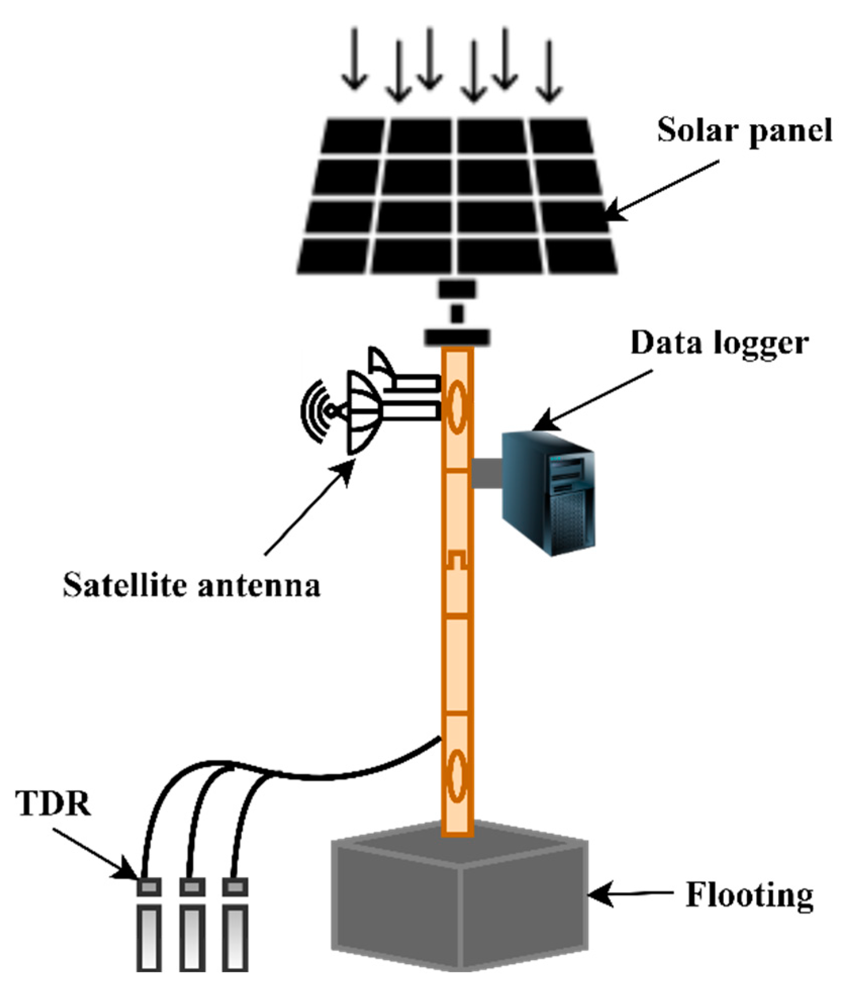
| TDR | Non-destructive and non-labor intensive. It can provide continuous measurements and has excellent spatial and temporal resolution. | Due to complex electronics, it is expensive equipment, and applicability in highly saline soils is limited while, in clay soils, conductivity is high | [77,78] |
| Tensiometer | Cost effective and non-destructive, if maintained adequately, a long period of use is possible. It can provide continuous measurement without distressing the soil. | Unsuitable moisture measurement in dry soils takes time to prove the result. Due to high maintenance conditions, it is not suitable for research. | [75,76] |
| Hydrometric | Suited for automatic measurements and requires low maintenance with the advantage of large area coverage. | A hydrometer is impractical because it consists of an extensive, complex, expensive system. | [75,79] |
| Ground-penetrating radar | Non-destructive technique and can cover a large area with high resolution. | Application is problematic on steep and rocky slopes due to the bulky antenna, and trees act as a reflector in the forest, which causes erroneous data. Due to their high conductivity, many soil types are radar opaque, dissipating radar energy and limiting its use. | [76,80] |
| CRNS | Non-contact allows quantification of averaged soil moisture over a large area using only one probe and does not affect field agricultural activity | The health risk is costly, complex, and unable to deliver accurate deep soil water content because of the inverse relation between depth and accuracy | [81,82] |
| Remote sensing | Suitable for large areas and can offer fast data collection repetitively. | Costly, complex, and cannot provide accurate soil moisture measurement information like conventional techniques at the point—significant effect of soil surface conditions, low penetration depth, and low temporal resolution. | [76,83] |
| Machine learning/deep learning | Handle massive amounts of data, spatial and temporal estimation is easy and roust for large areas; soft-computing technique requires no instrument/equipment | Experience personnel required to develop the models, costly in the sense of computing machines used and time required, need a huge amount for data collection for global generalization | [84,85] |
3.2.2. Gamma Attenuation
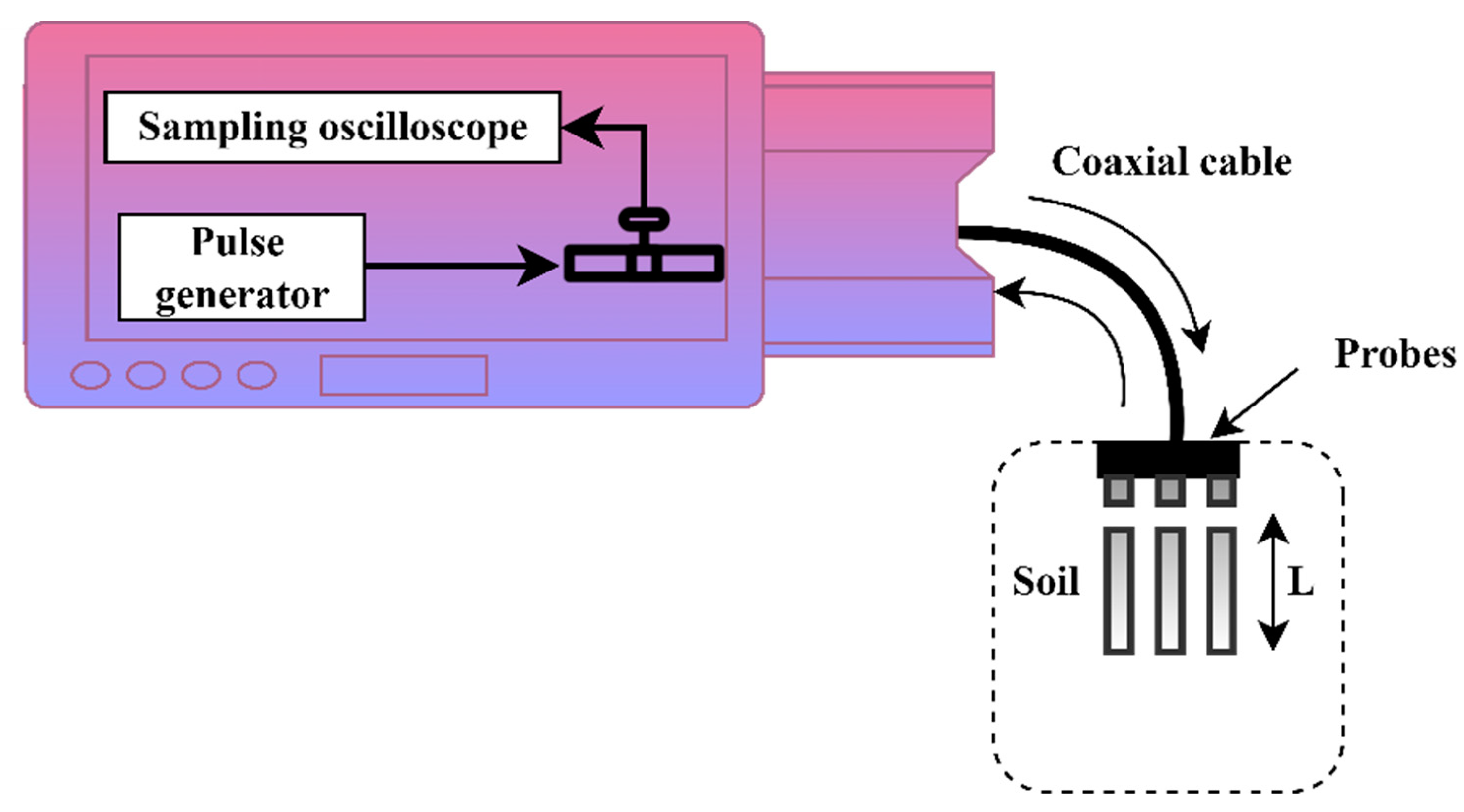
3.2.3. Time Domain Reflectometry (TDR) Sensor
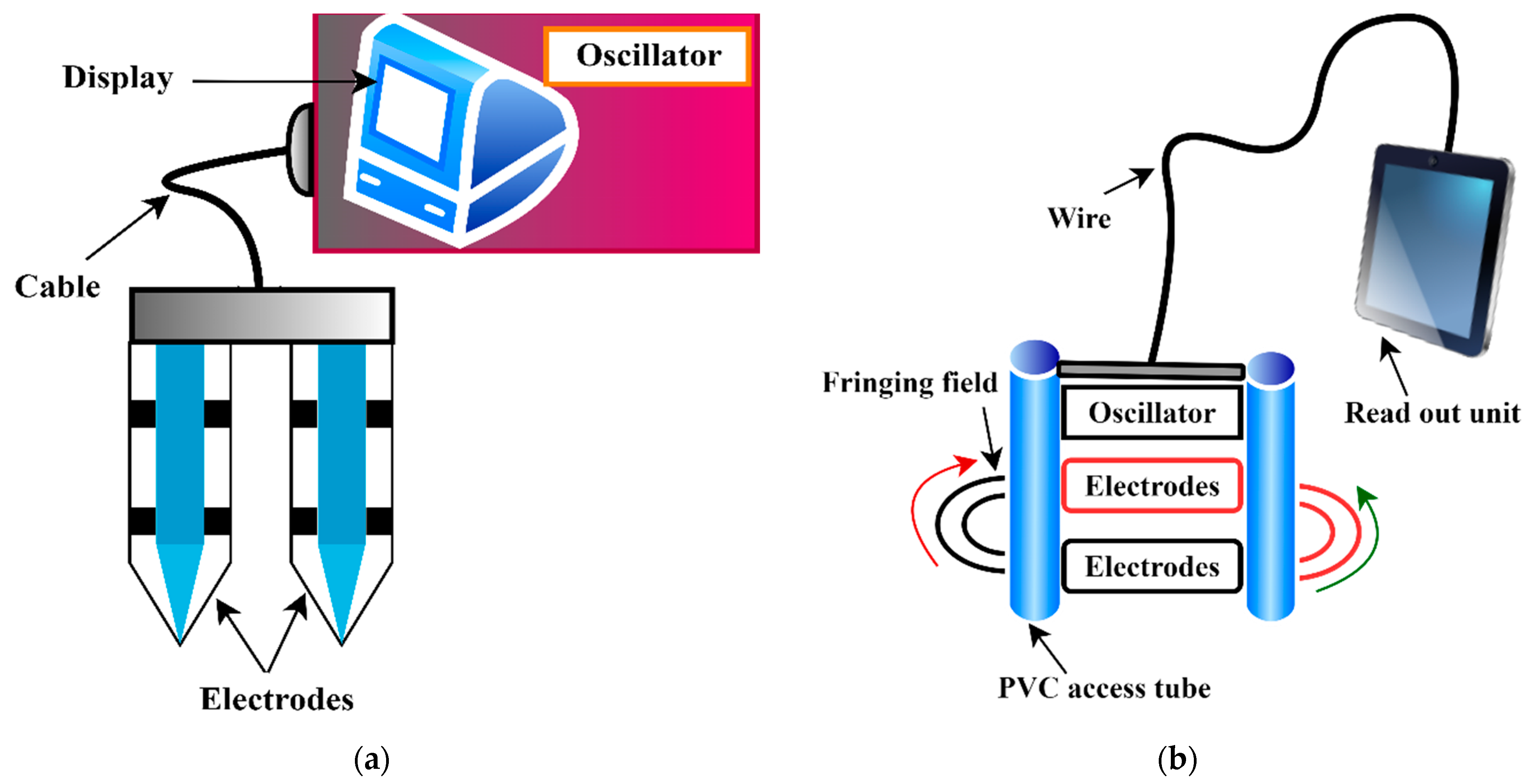
3.2.4. Capacitance Sensor and Frequency Domain Reflectometry (FDR)
3.2.5. Resistive Sensor
3.2.6. Tensiometer
3.2.7. Hygrometric Techniques
3.2.8. Ground-Penetrating Radar (GPR)
3.2.9. Cosmic-Ray Neutron Sensing (CRNS)
3.2.10. Remote Sensing Technique
| Groups | Methods | Advantages | Disadvantages | Literatures |
|---|---|---|---|---|
| Optical | Reflectance-based methods | Availability of multiple satellites with moderate spatial resolution, promising hyperspectral sensors | Failed to correlate SM in a highly vegetated cover, poor temporal resolution with limitations at night, and clouds cover | [108,109,110] |
| Thermal infrared-based methods | Availability of multiple satellites with moderate spatial resolution, promising relation of SSM to thermal inertia | Low temporal resolution and minimum correlation of SSM in a high vegetation cover, no measurement at cloudy conditions, and sensitivity to earth’s atmosphere | [111,112,113] | |
| Microwave passive | Various methods proposed | Results are mostly consistent over the bare soil surfaces; the method is feasible in clouds and daytime conditions with a higher temporal resolution | Coarse spatial resolution and vegetation cover, and surface roughness are a major influencing factor | [114,115] |
| Microwave active | Various methods (empirical, semiempirical, physically-based) | Fine spatial resolution can measure the SSM in clouds and daytime conditions | Low repetition of the satellite over the same place and accuracy is reliant upon the proportion of surface roughness and vegetation cover | [22,116,117] |
| Synergistic methods | Optical and thermal infrared | Fine spatial resolution supported by a range of satellite sensors | Empirical methods which limit the transferability and low accuracy in the cloudy state, and no nigh time measurements, low temporal resolution with lower moisture depth | [118,119] |
| Active and passive microwave (MW) | Enhanced temporal resolution and measurement of SSM | Validation should be carefully handled | [120,121] | |
| MW and optical | Sensitivity to the vegetation and surface roughness is minimized | Scaling and validation need careful interpretation | [122] |
3.2.11. Deep Learning/Machine Learning Techniques
4. A Critical Appraisal of the Measurement Techniques
5. Recommendation of Potential Soil Moisture Estimation Methods
6. Conclusions
Author Contributions
Funding
Institutional Review Board Statement
Informed Consent Statement
Data Availability Statement
Acknowledgments
Conflicts of Interest
References
- Brocca, L.; Ciabatta, L.; Massari, C.; Camici, S.; Tarpanelli, A. Soil Moisture for Hydrological Applications: Open Questions and New Opportunities. Water 2017, 9, 140. [Google Scholar] [CrossRef]
- Sarwar, A.; Peters, R.T.; Shafeeque, M.; Mohamed, A.; Arshad, A.; Ullah, I.; Saddique, N.; Muzammil, M.; Aslam, R.A. Accurate Measurement of Wind Drift and Evaporation Losses Could Improve Water Application Efficiency of Sprinkler Irrigation Systems—A Comparison of Measuring Techniques. Agric. Water Manag. 2021, 258, 107209. [Google Scholar] [CrossRef]
- Zhang, K.; Wang, S.; Bao, H.; Zhao, X. Characteristics and Influencing Factors of Rainfall-Induced Landslide and Debris Flow Hazards in Shaanxi Province, China. Nat. Hazards Earth Syst. Sci. 2019, 19, 93–105. [Google Scholar] [CrossRef]
- Zhang, K.; Ali, A.; Antonarakis, A.; Moghaddam, M.; Saatchi, S.; Tabatabaeenejad, A.; Chen, R.; Jaruwatanadilok, S.; Cuenca, R.; Crow, W.T.; et al. The Sensitivity of North American Terrestrial Carbon Fluxes to Spatial and Temporal Variation in Soil Moisture: An Analysis Using Radar-Derived Estimates of Root-Zone Soil Moisture. J. Geophys. Res. Biogeosci. 2019, 124, 3208–3231. [Google Scholar] [CrossRef]
- Quan, Q.; Liang, W.; Yan, D.; Lei, J. Influences of Joint Action of Natural and Social Factors on Atmospheric Process of Hydrological Cycle in Inner Mongolia, China. Urban Clim. 2022, 41, 101043. [Google Scholar] [CrossRef]
- Liu, Y.; Zhang, K.; Li, Z.; Liu, Z.; Wang, J.; Huang, P. A Hybrid Runoff Generation Modelling Framework Based on Spatial Combination of Three Runoff Generation Schemes for Semi-Humid and Semi-Arid Watersheds. J. Hydrol. 2020, 590, 125440. [Google Scholar] [CrossRef]
- Tian, H.; Huang, N.; Niu, Z.; Qin, Y.; Pei, J.; Wang, J. Mapping Winter Crops in China with Multi-Source Satellite Imagery and Phenology-Based Algorithm. Remote Sens. 2019, 11, 820. [Google Scholar] [CrossRef]
- Corti, T.; Wüest, M.; Bresch, D.; Seneviratne, S.I. Drought-Induced Building Damages from Simulations at Regional Scale. Nat. Hazards Earth Syst. Sci. 2011, 11, 3335–3342. [Google Scholar] [CrossRef]
- Tian, H.; Qin, Y.; Niu, Z.; Wang, L.; Ge, S. Summer Maize Mapping by Compositing Time Series Sentinel-1A Imagery Based on Crop Growth Cycles. J. Indian Soc. Remote Sens. 2021, 49, 2863–2874. [Google Scholar] [CrossRef]
- Tian, H.; Wang, Y.; Chen, T.; Zhang, L.; Qin, Y. Early-Season Mapping of Winter Crops Using Sentinel-2 Optical Imagery. Remote Sens. 2021, 13, 3822. [Google Scholar] [CrossRef]
- Bogena, H.R.; Huisman, J.A.; Güntner, A.; Hübner, C.; Kusche, J.; Jonard, F.; Vey, S.; Vereecken, H. Emerging Methods for Noninvasive Sensing of Soil Moisture Dynamics from Field to Catchment Scale: A Review. Wiley Interdiscip. Rev. Water 2015, 2, 635–647. [Google Scholar] [CrossRef]
- Qin, Y.; Xi, B.; Sun, X.; Zhang, H.; Xue, C.; Wu, B. Methane Emission Reduction and Biological Characteristics of Landfill Cover Soil Amended with Hydrophobic Biochar. Front. Bioeng. Biotechnol. 2022, 10, 905466. [Google Scholar] [CrossRef] [PubMed]
- Yin, L.; Wang, L.; Keim, B.D.; Konsoer, K.; Zheng, W. Wavelet Analysis of Dam Injection and Discharge in Three Gorges Dam and Reservoir with Precipitation and River Discharge. Water 2022, 14, 567. [Google Scholar] [CrossRef]
- van Zyl, J.J.; Kim, Y.; van Zyl, J.J. Applications: Measurement of Surface Soil Moisture. Chapter 2011, 5, 312. [Google Scholar]
- Zhao, T.; Shi, J.; Lv, L.; Xu, H.; Chen, D.; Cui, Q.; Jackson, T.J.; Yan, G.; Jia, L.; Chen, L.; et al. Soil Moisture Experiment in the Luan River Supporting New Satellite Mission Opportunities. Remote Sens. Environ. 2020, 240, 111680. [Google Scholar] [CrossRef]
- Everson, C.S.; Mengistu, M.G.; Vather, T. The Validation of the Variables (Evaporation and Soil Water) in Hydrometeorological Models: Phase II, Application of Cosmic Ray Probes for Soil Water Measurement. Water Res. Comm. Pretoria S. Afr. WRC Rep. 2017, 17. [Google Scholar]
- Mengistu, M.G.; Everson, C.S.; Moyo, N.C.; Savage, M.J. The Validation of the Variables (Evaporation and Soil Moisture) in Hydrometeorological Models. Water Res. Comm. Pretoria S. Afr. 2014. [Google Scholar]
- Chen, X.; Quan, Q.; Zhang, K.; Wei, J. Spatiotemporal Characteristics and Attribution of Dry/Wet Conditions in the Weihe River Basin within a Typical Monsoon Transition Zone of East Asia over the Recent 547 Years. Environ. Model. Softw. 2021, 143, 105116. [Google Scholar] [CrossRef]
- Huang, J. Hartemink, AE Soil and Environmental Issues in Sandy Soils. Earth-Sci. Rev. 2020, 208, 103295. [Google Scholar] [CrossRef]
- Zhao, T.; Shi, J.; Entekhabi, D.; Jackson, T.J.; Hu, L.; Peng, Z.; Yao, P.; Li, S.; Kang, C.S. Retrievals of Soil Moisture and Vegetation Optical Depth Using a Multi-Channel Collaborative Algorithm. Remote Sens. Environ. 2021, 257, 112321. [Google Scholar] [CrossRef]
- Su, N.; Jarvie, S.; Yan, Y.; Gong, X.; Li, F.; Han, P.; Zhang, Q. Landscape Context Determines Soil Fungal Diversity in a Fragmented Habitat. Catena 2022, 213, 106163. [Google Scholar] [CrossRef]
- Vereecken, H.; Huisman, J.A.; Pachepsky, Y.; Montzka, C.; Van Der Kruk, J.; Bogena, H.; Weihermüller, L.; Herbst, M.; Martinez, G.; Vanderborght, J. On the Spatio-Temporal Dynamics of Soil Moisture at the Field Scale. J. Hydrol. 2014, 516, 76–96. [Google Scholar] [CrossRef]
- Chen, Q.; Miao, F.; Wang, H.; Xu, Z.; Tang, Z.; Yang, L.; Qi, S. Downscaling of Satellite Remote Sensing Soil Moisture Products over the Tibetan Plateau Based on the Random Forest Algorithm: Preliminary Results. Earth Space Sci. 2020, 7, e2020EA001265. [Google Scholar] [CrossRef]
- Peng, J.; Loew, A. Recent Advances in Soil Moisture Estimation from Remote Sensing. Water 2017, 9, 530. [Google Scholar] [CrossRef]
- Rahimzadeh-Bajgiran, P.; Berg, A.A.; Champagne, C.; Omasa, K. Estimation of Soil Moisture Using Optical/Thermal Infrared Remote Sensing in the Canadian Prairies. ISPRS J. Photogramm. Remote Sens. 2013, 83, 94–103. [Google Scholar] [CrossRef]
- Zhang, J.; Zhou, Z.; Yao, F.; Yang, L.; Hao, C. Validating the Modified Perpendicular Drought Index in the North China Region Using in Situ Soil Moisture Measurement. IEEE Geosci. Remote Sens. Lett. 2014, 12, 542–546. [Google Scholar] [CrossRef]
- Martínez-Fernández, J.; Ceballos, A. Temporal Stability of Soil Moisture in a Large-field Experiment in Spain. Soil Sci. Soc. Am. J. 2003, 67, 1647–1656. [Google Scholar] [CrossRef]
- Robinson, D.A.; Campbell, C.S.; Hopmans, J.W.; Hornbuckle, B.K.; Jones, S.B.; Knight, R.; Ogden, F.; Selker, J.; Wendroth, O. Soil Moisture Measurement for Ecological and Hydrological Watershed-scale Observatories: A Review. Vadose Zo. J. 2008, 7, 358–389. [Google Scholar] [CrossRef]
- Martínez, G.; Pachepsky, Y.A.; Vereecken, H. Temporal Stability of Soil Water Content as Affected by Climate and Soil Hydraulic Properties: A Simulation Study. Hydrol. Process. 2014, 28, 1899–1915. [Google Scholar] [CrossRef]
- Pan, Y.-X.; Wang, X.-P.; Jia, R.-L.; Chen, Y.-W.; He, M.-Z. Spatial Variability of Surface Soil Moisture Content in a Re-Vegetated Desert Area in Shapotou, Northern China. J. Arid Environ. 2008, 72, 1675–1683. [Google Scholar] [CrossRef]
- Joshi, C.; Mohanty, B.P. Physical Controls of Near-Surface Soil Moisture across Varying Spatial Scales in an Agricultural Landscape during SMEX02. Water Resour. Res. 2010, 46, 12503. [Google Scholar] [CrossRef]
- Guo, X.; Fu, Q.; Hang, Y.; Lu, H.; Gao, F.; Si, J. Spatial Variability of Soil Moisture in Relation to Land Use Types and Topographic Features on Hillslopes in the Black Soil (Mollisols) Area of Northeast China. Sustainability 2020, 12, 3552. [Google Scholar] [CrossRef]
- Wang, S.; Zhang, K.; Chao, L.; Li, D.; Tian, X.; Bao, H.; Chen, G.; Xia, Y. Exploring the Utility of Radar and Satellite-Sensed Precipitation and Their Dynamic Bias Correction for Integrated Prediction of Flood and Landslide Hazards. J. Hydrol. 2021, 603, 126964. [Google Scholar] [CrossRef]
- Munyasya, A.N.; Koskei, K.; Zhou, R.; Liu, S.-T.; Indoshi, S.N.; Wang, W.; Zhang, X.-C.; Cheruiyot, W.K.; Mburu, D.M.; Nyende, A.B.; et al. Integrated On-Site & off-Site Rainwater-Harvesting System Boosts Rainfed Maize Production for Better Adaptation to Climate Change. Agric. Water Manag. 2022, 269, 107672. [Google Scholar] [CrossRef]
- Gao, Z.Q.; Liu, C.S.; Gao, W.; Chang, N.-B. A Coupled Remote Sensing and the Surface Energy Balance with Topography Algorithm (SEBTA) to Estimate Actual Evapotranspiration over Heterogeneous Terrain. Hydrol. Earth Syst. Sci. 2011, 15, 119. [Google Scholar] [CrossRef]
- Srivastava, A.; Yetemen, O.; Kumari, N.; Saco, P.M. Role of Solar Radiation and Topography on Soil Moisture Variations in Semiarid Aspect-Controlled Ecosystems. Sat 2018, 1, 1. [Google Scholar]
- Cheng, F.-Y.; Chen, Y. Variations in Soil Moisture and Their Impact on Land–Air Interactions during a 6-Month Drought Period in Taiwan. Geosci. Lett. 2018, 5, 26. [Google Scholar] [CrossRef]
- Oki, T.; Kanae, S. Global Hydrological Cycles and World Water Resources. Science 2006, 313, 1068–1072. [Google Scholar] [CrossRef]
- Lakshmi, V.; Jackson, T.J.; Zehrfuhs, D. Soil Moisture–Temperature Relationships: Results from Two Field Experiments. Hydrol. Process. 2003, 17, 3041–3057. [Google Scholar] [CrossRef]
- Easton, Z.M.; Bock, E.; Collick, A.S. Factors When Considering an Agricultural Drainage System. 2017. Available online: https://vtechworks.lib.vt.edu/bitstream/handle/10919/78540/BSE-208.pdf?sequence=1 (accessed on 1 August 2022).
- Petropoulos, G.P.; Griffiths, H.M.; Dorigo, W.; Xaver, A.; Gruber, A. Surface Soil Moisture Estimation: Significance, Controls and Conventional Measurement Techniques. In Remote Sensing of Energy Fluxes and Soil Moisture Content; CRC Press: Boca Raton, FL, USA, 2013; pp. 29–48. [Google Scholar]
- Moore, I.D.; Burch, G.J.; Mackenzie, D.H. Topographic Effects on the Distribution of Surface Soil Water and the Location of Ephemeral Gullies. Trans. ASAE 1988, 31, 1098–1107. [Google Scholar] [CrossRef]
- Panciera, R. Effect of Land Surface Heterogeneity on Satellite Near-Surface Soil Moisture Observations. Ph.D. Thesis, The University of Melbourne, Melbourne, Australia, 2009. [Google Scholar]
- Amooh, M.K.; Bonsu, M. Effects of Soil Texture and Organic Matter on Evaporative Loss of Soil Moisture. J. Glob. Agric. Ecol 2015, 3, 152–161. [Google Scholar]
- Giardina, C.P.; Ryan, M.G. Evidence That Decomposition Rates of Organic Carbon in Mineral Soil Do Not Vary with Temperature. Nature 2000, 404, 858–861. [Google Scholar] [CrossRef] [PubMed]
- Coenders-Gerrits, A.M.J.; Hopp, L.; Savenije, H.H.G.; Pfister, L. The Effect of Spatial Throughfall Patterns on Soil Moisture Patterns at the Hillslope Scale. Hydrol. Earth Syst. Sci. 2013, 17, 1749–1763. [Google Scholar] [CrossRef]
- Gwak, Y.; Kim, S. Factors Affecting Soil Moisture Spatial Variability for a Humid Forest Hillslope. Hydrol. Process. 2017, 31, 431–445. [Google Scholar] [CrossRef]
- Zhao, Y.; Peth, S.; Reszkowska, A.; Gan, L.; Krümmelbein, J.; Peng, X.; Horn, R. Response of Soil Moisture and Temperature to Grazing Intensity in a Leymus Chinensis Steppe, Inner Mongolia. Plant Soil 2011, 340, 89–102. [Google Scholar] [CrossRef]
- Ridley, A.M.; Burland, J.B. A New Instrument for the Measurement of Soil Moisture Suction. Geotechnique 1993, 43, 321–324. [Google Scholar] [CrossRef]
- Dorigo, W.A.; Wagner, W.; Hohensinn, R.; Hahn, S.; Paulik, C.; Xaver, A.; Gruber, A.; Drusch, M.; Mecklenburg, S.; van Oevelen, P. International Soil Moisture Network: A Data Hosting Facility for Global in Situ Soil Moisture Measurements. Hydrol. Earth Syst. Sci. 2011, 25, 5749–5804. [Google Scholar] [CrossRef]
- Robock, A.; Vinnikov, K.Y.; Srinivasan, G.; Entin, J.K.; Hollinger, S.E.; Speranskaya, N.A.; Liu, S.; Namkhai, A. The Global Soil Moisture Data Bank. Bull. Am. Meteorol. Soc. 2000, 81, 1281–1300. [Google Scholar] [CrossRef]
- Evett, S.R.; Steiner, J.L. Precision of Neutron Scattering and Capacitance Type Soil Water Content Gauges from Field Calibration. Soil Sci. Soc. Am. J. 1995, 59, 961–968. [Google Scholar] [CrossRef]
- Kashyap, B.; Kumar, R. Sensing Methodologies in Agriculture for Soil Moisture and Nutrient Monitoring. IEEE Access 2021, 9, 14095–14121. [Google Scholar] [CrossRef]
- Dutta, R. Remote Sensing of Energy Fluxes and Soil Moisture Content. J. Spat. Sci. 2015, 60, 196–197. [Google Scholar] [CrossRef]
- Verstraeten, W.W.; Veroustraete, F.; Feyen, J. Assessment of Evapotranspiration and Soil Moisture Content across Different Scales of Observation. Sensors 2008, 8, 70–117. [Google Scholar] [CrossRef] [PubMed]
- Zazueta, F.S.; Xin, J.N. Soil Moisture Sensors. Florida Cooperative Extension Service. Bulletin 1994, 292, 1–11. [Google Scholar]
- De Santis, D.; Furgiuele, F.; Biondi, D. Assimilation of Satellite Soil Moisture in Hydrological Modeling: Assessment of Observations Preprocessing and Error Characterization Methods. Ph.D. Thesis, Università della Calabria, Arcavacata, Italy, 2019. [Google Scholar]
- Zazueta, F.S.; Xin, J. Soil Moisture Sensors. Soil Sci. 1994, 73, 391–401. [Google Scholar]
- Jarvis, N.J.; Leeds-Harrison, P.B. Some Problems Associated with the Use of the Neutron Probe in Swelling/Shrinkling Clay Soils. J. Soil Sci. 1987, 38, 149–156. [Google Scholar] [CrossRef]
- Giese, K.; Tiemann, R. Determination of the Complex Permittivity from Thin-Sample Time Domain Reflectometry Improved Analysis of the Step Response Waveform. Adv. Mol. Relax. Process. 1975, 7, 45–59. [Google Scholar] [CrossRef]
- Rao, B.H.; Singh, D.N. Moisture Content Determination by TDR and Capacitance 14 Techniques: A Comparative Study. Int. J. Earth Sci. Eng. 2011, 4, 132–137. [Google Scholar]
- Su, S.L.; Singh, D.N.; Baghini, M.S. A Critical Review of Soil Moisture Measurement. Measurement 2014, 54, 92–105. [Google Scholar] [CrossRef]
- Enciso, J.; Porter, D.; Peries, X. Irrigation Monitoring with Soil Water Sensors (Spanish). 2007. Available online: https://hdl.handle.net/1969.1/87470 (accessed on 1 August 2022).
- Dobriyal, P.; Qureshi, A.; Badola, R.; Hussain, S.A. A Review of the Methods Available for Estimating Soil Moisture and Its Implications for Water Resource Management. J. Hydrol. 2012, 458, 110–117. [Google Scholar] [CrossRef]
- Robert, A. Dielectric Permittivity of Concrete between 50 Mhz and 1 GHz and GPR Measurements for Building Materials Evaluation. J. Appl. Geophys. 1998, 40, 89–94. [Google Scholar] [CrossRef]
- Iwema, J. Opportunities and Limitations of the Cosmic-Ray Neutron Soil Moisture Sensor under Humid Conditions. Ph.D. Thesis, University of Bristol, Bristol, UK, 2017. [Google Scholar]
- Zhan, C.; Dai, Z.; Samper, J.; Yin, S.; Ershadnia, R.; Zhang, X.; Wang, Y.; Yang, Z.; Luan, X.; Soltanian, M.R. An Integrated Inversion Framework for Heterogeneous Aquifer Structure Identification with Single-Sample Generative Adversarial Network. J. Hydrol. 2022, 610, 127844. [Google Scholar] [CrossRef]
- Liu, S.; Liu, Y.; Wang, C.; Dang, X. The Distribution Characteristics and Human Health Risks of High-Fluorine Groundwater in Coastal Plain: A Case Study in Southern Laizhou Bay, China. Front. Environ. Sci. 2022, 568. [Google Scholar] [CrossRef]
- Quan, Q.; Gao, S.; Shang, Y.; Wang, B. Assessment of the Sustainability of Gymnocypris Eckloni Habitat under River Damming in the Source Region of the Yellow River. Sci. Total Environ. 2021, 778, 146312. [Google Scholar] [CrossRef] [PubMed]
- Meigh, A.C.; Skipp, B.O. Gamma-Ray and Neutron Methods of Measuring Soil Density and Moisture. Geotechnique 1960, 10, 110–126. [Google Scholar] [CrossRef]
- Zhu, Q.; Liao, K.; Xu, Y.; Yang, G.; Wu, S.; Zhou, S. Monitoring and Prediction of Soil Moisture Spatial–Temporal Variations from a Hydropedological Perspective: A Review. Soil Res. 2013, 50, 625–637. [Google Scholar] [CrossRef]
- Gorthi, S.; Chakraborty, S.; Li, B.; Weindorf, D.C. A Field-Portable Acoustic Sensing Device to Measure Soil Moisture. Comput. Electron. Agric. 2020, 174, 105517. [Google Scholar] [CrossRef]
- Schmugge, T.J.; Jackson, T.J.; McKim, H.L. Survey of Methods for Soil Moisture Determination. Water Resour. Res. 1980, 16, 961–979. [Google Scholar] [CrossRef]
- Sharma, P.K.; Kumar, D.; Srivastava, H.S.; Patel, P. Assessment of Different Methods for Soil Moisture Estimation: A Review. J. Remote Sens. GIS 2018, 9, 57–73. [Google Scholar]
- Tarantino, A.; Ridley, A.M.; Toll, D.G. Field Measurement of Suction, Water Content, and Water Permeability. Geotech. Geol. Eng. 2008, 26, 751–782. [Google Scholar] [CrossRef]
- Jones, S.B.; Wraith, J.M.; Or, D. Time Domain Reflectometry Measurement Principles and Applications. Hydrol. Process. 2002, 16, 141–153. [Google Scholar] [CrossRef]
- Munoth, P.; Goyal, R.; Garg, A. Estimation of Soil Moisture and Its Application to Irrigation Water Allocation: A Review. In Proceedings of the International Conference on Hydraulics, Water Resourcesand Coastal Engineering (Hydro2016), CWPRS Pune, India, 8–10 December 2016. [Google Scholar]
- Petropoulos, G.P.; Ireland, G.; Barrett, B. Surface Soil Moisture Retrievals from Remote Sensing: Current Status, Products & Future Trends. Phys. Chem. Earth Parts A/B/C 2015, 83, 36–56. [Google Scholar]
- Huisman, J.A.; Sperl, C.; Bouten, W.; Verstraten, J.M. Soil Water Content Measurements at Different Scales: Accuracy of Time Domain Reflectometry and Ground-Penetrating Radar. J. Hydrol. 2001, 245, 48–58. [Google Scholar] [CrossRef]
- Nguyen, H.H.; Jeong, J.; Choi, M. Extension of Cosmic-Ray Neutron Probe Measurement Depth for Improving Field Scale Root-Zone Soil Moisture Estimation by Coupling with Representative in-Situ Sensors. J. Hydrol. 2019, 571, 679–696. [Google Scholar] [CrossRef]
- Stevanato, L.; Baroni, G.; Cohen, Y.; Cristiano Lino, F.; Gatto, S.; Lunardon, M.; Marinello, F.; Moretto, S.; Morselli, L. A Novel Cosmic-Ray Neutron Sensor for Soil Moisture Estimation over Large Areas. Agriculture 2019, 9, 202. [Google Scholar] [CrossRef]
- Köhli, M.; Schrön, M.; Zreda, M.; Schmidt, U.; Dietrich, P.; Zacharias, S. Footprint Characteristics Revised for Field-scale Soil Moisture Monitoring with Cosmic-ray Neutrons. Water Resour. Res. 2015, 51, 5772–5790. [Google Scholar] [CrossRef]
- Ali, I.; Greifeneder, F.; Stamenkovic, J.; Neumann, M.; Notarnicola, C. Review of Machine Learning Approaches for Biomass and Soil Moisture Retrievals from Remote Sensing Data. Remote Sens. 2015, 7, 16398–16421. [Google Scholar] [CrossRef]
- Cai, Y.; Zheng, W.; Zhang, X.; Zhangzhong, L.; Xue, X. Research on Soil Moisture Prediction Model Based on Deep Learning. PLoS ONE 2019, 14, e0214508. [Google Scholar] [CrossRef]
- Colgate, S.A. Gamma-Ray Absorption Measurements. Phys. Rev. 1952, 87, 592. [Google Scholar] [CrossRef]
- Pires, L.F. Soil Analysis Using Nuclear Techniques: A Literature Review of the Gamma Ray Attenuation Method. Soil Tillage Res. 2018, 184, 216–234. [Google Scholar] [CrossRef]
- Pandey, J.; Chamoli, V.; Prakash, R. A Review: Soil Moisture Estimation Using Different Techniques. In Intelligent Communication, Control and Devices; Springer: Berlin/Heidelberg, Germany, 2020; pp. 105–111. [Google Scholar]
- Noborio, K. Measurement of Soil Water Content and Electrical Conductivity by Time Domain Reflectometry: A Review. Comput. Electron. Agric. 2001, 31, 213–237. [Google Scholar] [CrossRef]
- Gardner, C.M.K.; Dean, T.J.; Cooper, J.D. Soil Water Content Measurement with a High-Frequency Capacitance Sensor. J. Agric. Eng. Res. 1998, 71, 395–403. [Google Scholar] [CrossRef]
- Hu, S.; Wu, H.; Liang, X.; Xiao, C.; Zhao, Q.; Cao, Y.; Han, X. A Preliminary Study on the Eco-Environmental Geological Issue of in-Situ Oil Shale Mining by a Physical Model. Chemosphere 2022, 287, 131987. [Google Scholar] [CrossRef] [PubMed]
- Minet, J.; Lambot, S.; Delaide, G.; Huisman, J.A.; Vereecken, H.; Vanclooster, M. A Generalized Frequency Domain Reflectometry Modeling Technique for Soil Electrical Properties Determination. Vadose Zo. J. 2010, 9, 1063–1072. [Google Scholar] [CrossRef]
- Robinson, M.; Dean, T.J. Measurement of near Surface Soil Water Content Using a Capacitance Probe. Hydrol. Process. 1993, 7, 77–86. [Google Scholar] [CrossRef]
- Whalley, W.R.; Dean, T.J.; Izzard, P. Evaluation of the Capacitance Technique as a Method for Dynamically Measuring Soil Water Content. J. Agric. Eng. Res. 1992, 52, 147–155. [Google Scholar] [CrossRef]
- Seyfried, M.S.; Grant, L.E.; Du, E.; Humes, K. Dielectric Loss and Calibration of the Hydra Probe Soil Water Sensor. Vadose Zo. J. 2005, 4, 1070–1079. [Google Scholar] [CrossRef]
- Benninga, H.-J.F.; Carranza, C.D.U.; Pezij, M.; van Santen, P.; van der Ploeg, M.J.; Augustijn, D.; van der Velde, R. The Raam Regional Soil Moisture Monitoring Network in the Netherlands. Earth Syst. Sci. Data 2018, 10, 61–79. [Google Scholar] [CrossRef]
- Vaz, C.M.P.; Jones, S.; Meding, M.; Tuller, M. Evaluation of Standard Calibration Functions for Eight Electromagnetic Soil Moisture Sensors. Vadose Zo. J. 2013, 12, 1–16. [Google Scholar] [CrossRef]
- Singh, D.N.; Kuriyan, S.J. Estimation of Hydraulic Conductivity of Unsaturated Soils Using a Geotechnical Centrifuge. Can. Geotech. J. 2002, 39, 684–694. [Google Scholar] [CrossRef]
- Singh, D.N.; Kuriyan, S.J. Estimation of Unsaturated Hydraulic Conductivity Using Soil Suction Measurements Obtained by an Insertion Tensiometer. Can. Geotech. J. 2003, 40, 476–483. [Google Scholar] [CrossRef]
- Rinaldi, V.A.; Francisca, F.M. Impedance Analysis of Soil Dielectric Dispersion (1 MHz–1 GHz). J. Geotech. Geoenviron. Eng. 1999, 125, 111–121. [Google Scholar] [CrossRef]
- Macdonald, J.R. Impedance Spectroscopy. Ann. Biomed. Eng. 1992, 20, 289–305. [Google Scholar] [CrossRef] [PubMed]
- Ochsner, T.E.; Cosh, M.H.; Cuenca, R.H.; Dorigo, W.A.; Draper, C.S.; Hagimoto, Y.; Kerr, Y.H.; Larson, K.M.; Njoku, E.G.; Small, E.E. State of the Art in Large-scale Soil Moisture Monitoring. Soil Sci. Soc. Am. J. 2013, 77, 1888–1919. [Google Scholar] [CrossRef]
- Zreda, M.; Shuttleworth, W.J.; Zeng, X.; Zweck, C.; Desilets, D.; Franz, T.; Rosolem, R. COSMOS: The Cosmic-Ray Soil Moisture Observing System. Hydrol. Earth Syst. Sci. 2012, 16, 4079–4099. [Google Scholar] [CrossRef]
- Fernández-Prieto, D.; Van Oevelen, P.; Su, Z.; Wagner, W. Advances in Earth Observation for Water Cycle Science. Hydrol. Earth Syst. Sci. 2012, 16, 543–549. [Google Scholar] [CrossRef]
- Mohanty, B.P.; Cosh, M.H.; Lakshmi, V.; Montzka, C. Soil Moisture Remote Sensing: State-of-the-science. Vadose Zo. J. 2017, 16, 1–9. [Google Scholar] [CrossRef]
- Wagner, W.; Blöschl, G.; Pampaloni, P.; Calvet, J.-C.; Bizzarri, B.; Wigneron, J.-P.; Kerr, Y. Operational Readiness of Microwave Remote Sensing of Soil Moisture for Hydrologic Applications. Hydrol. Res. 2007, 38, 1–20. [Google Scholar] [CrossRef]
- Yang, Y.; Guan, H.; Long, D.; Liu, B.; Qin, G.; Qin, J.; Batelaan, O. Estimation of Surface Soil Moisture from Thermal Infrared Remote Sensing Using an Improved Trapezoid Method. Remote Sens. 2015, 7, 8250–8270. [Google Scholar] [CrossRef]
- Gerhards, M.; Schlerf, M.; Mallick, K.; Udelhoven, T. Challenges and Future Perspectives of Multi-/Hyperspectral Thermal Infrared Remote Sensing for Crop Water-Stress Detection: A Review. Remote Sens. 2019, 11, 1240. [Google Scholar] [CrossRef]
- Anne, N.J.P.; Abd-Elrahman, A.H.; Lewis, D.B.; Hewitt, N.A. Modeling Soil Parameters Using Hyperspectral Image Reflectance Insubtropical Coastal Wetlands. Int. J. Appl. Earth Obs. Geoinf. 2014, 33, 47–56. [Google Scholar] [CrossRef]
- Gao, Z.; Xu, X.; Wang, J.; Yang, H.; Huang, W.; Feng, H. A Method of Estimating Soil Moisture Based on the Linear Decomposition of Mixture Pixels. Math. Comput. Model. 2013, 58, 606–613. [Google Scholar] [CrossRef]
- Huan-Jun, L.I.U.; ZHANG, Y.-Z.; ZHANG, X.-L.; Zhang, B.; Kai-Shan, S.; Zong-Ming, W.; Na, T. Quantitative Analysis of Moisture Effect on Black Soil Reflectance. Pedosphere 2009, 19, 532–540. [Google Scholar]
- Lei, S.; Bian, Z.; Daniels, J.L.; Liu, D. Improved Spatial Resolution in Soil Moisture Retrieval at Arid Mining Area Using Apparent Thermal Inertia. Trans. Nonferrous Met. Soc. China 2014, 24, 1866–1873. [Google Scholar] [CrossRef]
- Minacapilli, M.; Agnese, C.; Blanda, F.; Cammalleri, C.; Ciraolo, G.; D’Urso, G.; Iovino, M.; Pumo, D.; Provenzano, G.; Rallo, G. Estimation of Actual Evapotranspiration of Mediterranean Perennial Crops by Means of Remote-Sensing Based Surface Energy Balance Models. Hydrol. Earth Syst. Sci. 2009, 13, 1061–1074. [Google Scholar] [CrossRef]
- Qin, J.; Yang, K.; Lu, N.; Chen, Y.; Zhao, L.; Han, M. Spatial Upscaling of In-Situ Soil Moisture Measurements Based on MODIS-Derived Apparent Thermal Inertia. Remote Sens. Environ. 2013, 138, 1–9. [Google Scholar] [CrossRef]
- Kong, X.; Dorling, S.R. Near-Surface Soil Moisture Retrieval from ASAR Wide Swath Imagery Using a Principal Component Analysis. Int. J. Remote Sens. 2008, 29, 2925–2942. [Google Scholar] [CrossRef]
- Pan, M.; Sahoo, A.K.; Wood, E.F. Improving Soil Moisture Retrievals from a Physically-Based Radiative Transfer Model. Remote Sens. Environ. 2014, 140, 130–140. [Google Scholar] [CrossRef]
- Al-Bakri, J.; Suleiman, A.; Berg, A. A Comparison of Two Models to Predict Soil Moisture from Remote Sensing Data of RADARSAT II. Arab. J. Geosci. 2014, 7, 4851–4860. [Google Scholar] [CrossRef]
- Callens, M.; Verhoest, N.E.C.; Davidson, M.W.J. Parameterization of Tillage-Induced Single-Scale Soil Roughness from 4-m Profiles. IEEE Trans. Geosci. Remote Sens. 2006, 44, 878–887. [Google Scholar] [CrossRef]
- Holzman, M.E.; Rivas, R.; Piccolo, M.C. Estimating Soil Moisture and the Relationship with Crop Yield Using Surface Temperature and Vegetation Index. Int. J. Appl. Earth Obs. Geoinf. 2014, 28, 181–192. [Google Scholar] [CrossRef]
- Wang, L.; Qu, J.J.; Zhang, S.; Hao, X.; Dasgupta, S. Soil Moisture Estimation Using MODIS and Ground Measurements in Eastern China. Int. J. Remote Sens. 2007, 28, 1413–1418. [Google Scholar] [CrossRef]
- Liu, Y.Y.; Dorigo, W.A.; Parinussa, R.M.; De Jeu, R.A.M.; Wagner, W.; McCabe, M.F.; Evans, J.P.; Van Dijk, A.I.J.M. Trend-Preserving Blending of Passive and Active Microwave Soil Moisture Retrievals. Remote Sens. Environ. 2012, 123, 280–297. [Google Scholar] [CrossRef]
- Narayan, U.; Lakshmi, V.; Jackson, T.J. High-Resolution Change Estimation of Soil Moisture Using L-Band Radiometer and Radar Observations Made during the SMEX02 Experiments. IEEE Trans. Geosci. Remote Sens. 2006, 44, 1545–1554. [Google Scholar] [CrossRef]
- Zhao, W.; Li, Z.-L. Sensitivity Study of Soil Moisture on the Temporal Evolution of Surface Temperature over Bare Surfaces. Int. J. Remote Sens. 2013, 34, 3314–3331. [Google Scholar] [CrossRef]
- Sarwar, A.; Peters, R.T.; Mohamed, A.Z. Linear Mixed Modeling and Artificial Neural Network Techniques for Predicting Wind Drift and Evaporation Losses under Moving Sprinkler Irrigation Systems. Irrig. Sci. 2020, 38, 177–188. [Google Scholar] [CrossRef]
- Ahmad, S.; Kalra, A.; Stephen, H. Estimating Soil Moisture Using Remote Sensing Data: A Machine Learning Approach. Adv. Water Resour. 2010, 33, 69–80. [Google Scholar] [CrossRef]
- Prasad, R.; Deo, R.C.; Li, Y.; Maraseni, T. Soil Moisture Forecasting by a Hybrid Machine Learning Technique: ELM Integrated with Ensemble Empirical Mode Decomposition. Geoderma 2018, 330, 136–161. [Google Scholar] [CrossRef]
- Li, X.; Wang, Y.; Hu, Y.; Zhou, C.; Zhang, H. Numerical Investigation on Stratum and Surface Deformation in Underground Phosphorite Mining Under Different Mining Methods. Front. Earth Sci. 2022, 10. [Google Scholar] [CrossRef]
- Xie, W.; Li, X.; Jian, W.; Yang, Y.; Liu, H.; Robledo, L.F.; Nie, W. A Novel Hybrid Method for Landslide Susceptibility Mapping-Based GeoDetector and Machine Learning Cluster: A Case of Xiaojin County, China. ISPRS Int. J. Geo-Inf. 2021, 10, 93. [Google Scholar] [CrossRef]
- Yinglan, A.; Wang, G.; Hu, P.; Lai, X.; Xue, B.; Fang, Q. Root-Zone Soil Moisture Estimation Based on Remote Sensing Data and Deep Learning. Environ. Res. 2022, 212, 113278. [Google Scholar]
- Song, X.; Zhang, G.; Liu, F.; Li, D.; Zhao, Y.; Yang, J. Modeling Spatio-Temporal Distribution of Soil Moisture by Deep Learning-Based Cellular Automata Model. J. Arid Land 2016, 8, 734–748. [Google Scholar] [CrossRef]
- Lee, C.S.; Sohn, E.; Park, J.D.; Jang, J.-D. Estimation of Soil Moisture Using Deep Learning Based on Satellite Data: A Case Study of South Korea. GIScience Remote Sens. 2019, 56, 43–67. [Google Scholar] [CrossRef]
- Sarwar, A.; Peters, R.T.; Mehanna, H.; Amini, M.Z.; Mohamed, A.Z. Evaluating Water Application Efficiency of Low and Mid Elevation Spray Application under Changing Weather Conditions. Agric. Water Manag. 2019, 221, 84–91. [Google Scholar] [CrossRef]
- Zhao, Z.-Y.; Wang, P.-Y.; Xiong, X.-B.; Wang, Y.-B.; Zhou, R.; Tao, H.-Y.; Grace, U.A.; Wang, N.; Xiong, Y.-C. Environmental Risk of Multi-Year Polythene Film Mulching and Its Green Solution in Arid Irrigation Region. J. Hazard. Mater. 2022, 435, 128981. [Google Scholar] [CrossRef]
- Yuan, Q.; Xu, H.; Li, T.; Shen, H.; Zhang, L. Estimating Surface Soil Moisture from Satellite Observations Using a Generalized Regression Neural Network Trained on Sparse Ground-Based Measurements in the Continental US. J. Hydrol. 2020, 580, 124351. [Google Scholar] [CrossRef]
- Dean, S.; Bhat, A.; Singh, D. A Generalized Relationship for Estimating Dielectric Constant of Soils. J. Astm Int. 2007, 4. [Google Scholar] [CrossRef]
- Cape, J. A Value Selection Method for Choosing between Alternative Soil Moisture Sensors. Project No. AIT2. L. Water Resour. Res. Dev. Corp. Rep. 1997. Available online: http://www.insidecotton.com/jspui/bitstream/1/1938/2/er970334.pdf (accessed on 1 August 2022).
- Charlesworth, B.; Charlesworth, D.; Barton, N.H. The Effects of Genetic and Geographic Structure on Neutral Variation. Annu. Rev. Ecol. Evol. Syst. 2003, 34, 99–125. [Google Scholar] [CrossRef]
- Muñoz-Carpena, R. Field Devices for Monitoring Soil Water Content: BUL343/AE266, 7/2004. EDIS 2004, 2004. [Google Scholar] [CrossRef]


| Factors | Description | References | |
|---|---|---|---|
| Climate | Incoming solar radiation | The temperature of soil and soil moisture is changed. It controls the ionic composition of soil solutions by influencing the release rates of plant litter and soil nutrients. | [35] |
| Precipitation | In the case of spatial changes and uniform radiation, the heterogeneous precipitation over the landscape will cause significant changes in soil moisture. | [36] | |
| Evapotranspiration (ET) | Through the ET process, soil moisture is a significant source of atmospheric water vapor, including bare soil surface evaporation and plant transpiration. | [37,38] | |
| Temperature | Surface temperature affects the flux of longwave, sensible, and underground heat emitted. The magnitude of these fluxes controls the latent heat fluctuation. | [39] | |
| Topography | Slope | Slopes affect processes such as seepage, underground drainage, and runoff. In steep fields, excess water can move laterally downhill in the soil and drain faster than in flat areas. | [26] |
| Aspect and Gradient | The rate of ET from the surface of the soil and, consequently, SSM is affected as aspects and gradients are shown to directly regulate the received solar radiation. | [40] | |
| Curvature | High curvature of soil surface areas tends to cause more SSM heterogeneity than areas with low planar curvature. | [41,42] | |
| Relative elevation | Relative elevation (called slope position) directly influences how soil precipitation impacts SSM and indirectly influences soil surface moisture by affecting soil water redistribution. | [41,42] | |
| Soil Properties | Texture | The texture is a significant factor that can influence the moisture permeation and water holding on the soil surface. Coarse-textured soils with the highest content of sand are more drainable than soils with finer textures (for instance, clay), resulting in lower water retention and SSM. | [43] |
| Organic matter | As the particle size decreases, the decomposition of organic matter also decreases, resulting in lower water retention and an increased evaporation rate. | [44,45] | |
| Macro porosity | Sandy soils have few but large pores between individual particles. These macropores retain air but not water. Therefore, water is freely drained through the sandy soil compared to the clay soil. | [44,45] | |
| Vegetation | Trees | The transpiration process requires water, which is observed through root zone moisture and affects the soil water dynamics | [46,47] |
| Land use types | Land use | Land mainly affects plants and related influences on infiltration rate, runoff rate, and evapotranspiration process, which show more obvious effects during the growing season. | [41,48] |
| Type of Sensors | Sensors | Accuracy | Measurement Range | Repeatability | Operating Frequency | Literatures |
|---|---|---|---|---|---|---|
| TDR | TRIME PICO 64/32 | Not reported | 0–100% ϴ | 0.20% | IMKO devices [62] | |
| TRIME PICO IPH/T3 | 0.30% | |||||
| TRIME-IT/-EZ | ±1% ϴ for 0–0.40 m3/m3; ±2% ϴ for 0.40–0.70 m3/m3 | 5 and 15 cm depth | Not reported | 1 GHZ | ||
| 5TM | ±0.03 m3 m−3 | 5–80 cm | Not reported | 70 MHz | [95] | |
| FDR | CS616 | ±2.5% ϴ for 0 and 0.50 m3 m−3; | Not reported | 70 MHZ | Campbell Scientific Schlaeger [62] | |
| SISOMOP Schlaeger | Relative accuracy of the permittivity of ±4% | 0–1 m3 m−3 | ||||
| Capacitance type technique | 5TE soil moisture sensor | ±1 ka for (1–40 ka) and ±5 ka for (40–80 ka) 0–100% | 0–100% ϴ | Not reported | ||
| EC 5 soil moisture sensor | ±3% ϴ most mineral soils up to 8 dS/m ± 1–2% ϴ with soil-specific calibration | Decagon Devices [62] | ||||
| ECH2O Probes | ±4% ϴ in medium-textured soils without calibration, and an accuracy of 1–2% ϴ with a soil-specific calibration | 0–40% ϴ | ||||
| 10HS | As per standard calibration, ±0.03 m3/m3 in mineral soils; and ±0.02 m3/m3 depending upon soil-specific calibration | 0% and 57% ϴ | 70 MHZ |
| TEROS12 | TEROS11 | TEROS10 | EC-5 | 10HS | |
|---|---|---|---|---|---|
| Measures | Volumetric water content, temperature, electrical conductivity | Volumetric water content, temperature, | Volumetric water content | Volumetric water content | Volumetric water content |
| Volume of Influence | 1010 mL | 1010 mL | 430 mL | 240 mL | 1320 mL |
| Measurement Output | Digital SDI-12 | Digital SDI-12 | Analog | Analog | Analog |
| Field Lifespan | 10+ years | 10+ years | 10+ years | 3–5 years * | 3–5 years * |
| Durability | Highest | Highest | Highest | Moderate | Moderate |
| Installation | Installation tool for high accuracy | Installation tool for high accuracy | Installation tool for high accuracy | Install by hand | Install by hand |
| Soil | Clay | Silt | Sand | ρp † | ρb | f | SSA | LOI | CEC | EC | pH (CaCl2) |
|---|---|---|---|---|---|---|---|---|---|---|---|
| % | g cm−3 | cm cm−3 | m2 g−1 | % | mmolc/100 g | dS m−1 | |||||
| AZ2 | 3 | 4.3 | 92.7 | 2.63 | 1.55 | 0.42 | 1.8 | 0.6 | 1.8 | 1.21 | 7.3 |
| AZ6 | 21.5 | 21.4 | 57.1 | 2.59 | 1.4 | 0.55 | 17.5 | 2.1 | 8.2 | 1.32 | 7.6 |
| AZ9 | 20.9 | 59.7 | 19.4 | 2.57 | 1.13 | 0.61 | 8.8 | 10 | 30.7 | 1.4 | 6.3 |
| AZ11 | 36.7 | 37 | 26.3 | 2.69 | 1.36 | 0.6 | 30.1 | 3.4 | 14.1 | 0.94 | 7.9 |
| AZ15 | 28 | 62.9 | 9.1 | 2.46 | 1.3 | 0.58 | 21.6 | 5.5 | 21.3 | 8.39 | 7.4 |
| AZ18 | 68.9 | 17.7 | 13.4 | 2.61 | 1.3 | 0.63 | 50.8 | 6 | 16.3 | 1.65 | 6.5 |
| ORG | 2.6 | 13.7 | 83.7 | 1.83 | 0.38 | 0.79 | 2.1 | 55.1 | 27.3 | 4.8 | 5.9 |
| Sensor | AZ2 | AZ6 | AZ9 | AZ11 | AZ15 | AZ18 | ORG | AV1 † | AV2 ‡ |
|---|---|---|---|---|---|---|---|---|---|
| TDR100 | 0.009 | 0.016 | 0.034 | 0.026 | 0.024 | 0.042 | 0.013 | 0.023 | 0.023 |
| Wet2 | 0.023 | 0.018 | 0.019 | 0.046 | 0.078 | 0.051 | 0.046 | 0.04 | 0.034 |
| 5TE | 0.05 | 0.036 | 0.04 | 0.033 | 0.083 | 0.039 | 0.041 | 0.046 | 0.04 |
| 10HS | 0.077 | 0.064 | 0.084 | 0.063 | 0.086 | 0.078 | - | 0.075 | 0.073 |
| SM300 | 0.019 | 0.036 | 0.039 | 0.049 | 0.136 | 0.047 | 0.035 | 0.052 | 0.037 |
| Theta P. | 0.02 | 0.029 | 0.02 | 0.042 | 0.091 | 0.026 | 0.014 | 0.035 | 0.025 |
| Hydra P. | 0.018 | 0.042 | 0.039 | 0.068 | 0.272 | 0.056 | 0.046 | 0.077 | 0.045 |
| CS616 | 0.058 | 0.156 | 0.049 | 0.157 | 0.962 | 0.169 | 0.179 | 0.247 | 0.128 |
Publisher’s Note: MDPI stays neutral with regard to jurisdictional claims in published maps and institutional affiliations. |
© 2022 by the authors. Licensee MDPI, Basel, Switzerland. This article is an open access article distributed under the terms and conditions of the Creative Commons Attribution (CC BY) license (https://creativecommons.org/licenses/by/4.0/).
Share and Cite
Rasheed, M.W.; Tang, J.; Sarwar, A.; Shah, S.; Saddique, N.; Khan, M.U.; Imran Khan, M.; Nawaz, S.; Shamshiri, R.R.; Aziz, M.; et al. Soil Moisture Measuring Techniques and Factors Affecting the Moisture Dynamics: A Comprehensive Review. Sustainability 2022, 14, 11538. https://0-doi-org.brum.beds.ac.uk/10.3390/su141811538
Rasheed MW, Tang J, Sarwar A, Shah S, Saddique N, Khan MU, Imran Khan M, Nawaz S, Shamshiri RR, Aziz M, et al. Soil Moisture Measuring Techniques and Factors Affecting the Moisture Dynamics: A Comprehensive Review. Sustainability. 2022; 14(18):11538. https://0-doi-org.brum.beds.ac.uk/10.3390/su141811538
Chicago/Turabian StyleRasheed, Muhammad Waseem, Jialiang Tang, Abid Sarwar, Suraj Shah, Naeem Saddique, Muhammad Usman Khan, Muhammad Imran Khan, Shah Nawaz, Redmond R. Shamshiri, Marjan Aziz, and et al. 2022. "Soil Moisture Measuring Techniques and Factors Affecting the Moisture Dynamics: A Comprehensive Review" Sustainability 14, no. 18: 11538. https://0-doi-org.brum.beds.ac.uk/10.3390/su141811538