


Effects of River Scale on the Aesthetic Quality of Urban On-Water Sightseeing
School of Landscape Architecture, Beijing Forestry University, Beijing 100083, China
*
Authors to whom correspondence should be addressed.
†
These authors contributed equally to this work.
Sustainability 2022, 14(19), 12543; https://0-doi-org.brum.beds.ac.uk/10.3390/su141912543
Submission received: 24 August 2022
/
Revised: 21 September 2022
/
Accepted: 27 September 2022
/
Published: 1 October 2022
(This article belongs to the Collection Sustainability of Water Environment)
Abstract
:On-water sightseeing plays a key role in the tourism of traditional Chinese landscapes. The on-water landscape affects tourism potential and the quality of urban landscapes. Current research on river landscape is mainly based on remote sensing images or on-land approaches, while studies of on-water perspective landscapes at different river scales is lacking. In this paper, with Guilin city rivers taken as an example, we adopt image semantic segmentation technology to evaluate the visual landscape characteristics under different river scales, and subsequently employ automatic linear modeling to screen important factors affecting aesthetic quality. The results reveal the obvious differences between the on-water landscape characteristics of different scale rivers. The on-water landscape quality of large- and small-scale rivers is mainly affected by seven and four factors, respectively. The Karst landform of Guilin is observed to significantly improve the on-water landscape quality of large-scale rivers. By considering the impact mechanism of landscape composition on the aesthetic quality and the different scale rivers, we propose several aesthetic quality improvement strategies based on low-cost methods, including the planting of vegetation and the micro renewal of artificial constructions. This study contributes to the intelligent evaluation of urban on-water landscape and provides reference for on-water route selection and urban planning.
1. Introduction
The blue-green system of the urban river channel reflects the characteristics of the natural environment of a city. In the process of urban development, rivers go through the process of “ecological destruction to environmental transformation to waterfront recreation to water tourism” [1]. The production and transportation functions of river transport have gradually been replaced by ecological and recreational purposes. In recent years, many scholars have started to investigate the river landscape quality in terms of macro scale urban river ecological regulation services. Satellite and Unmanned Aerial Vehicle (UAV) remote sensing technology have been employed to extract river basin information for environmental monitoring, landscape pattern changes, visual attribute assessments and river ecosystem health assessments [2,3,4,5]. Furthermore, urban river regeneration projects are no longer limited to meeting the urban ecological barrier and providing natural resources on a large scale, but they have also become one of the most important spatial carriers of tourism activities [6]. More attention is focused on improving the cultural service functions of river ecosystems from a humanistic perspective.
The visual environment is considered an important resource, similar to water, soil and mineral resources [7], and the quality of visual environments affects people’s aesthetic taste and physical and mental health [8]. With the development of landscape aesthetics dominated by preference and perception, the evaluation of landscape visual aesthetics has attracted increasing attention and emerged as an important branch of landscape aesthetics. Such evaluations essentially assign a value to the landscape and identify its main evaluation elements in order to predict landscape changes caused by landscape or management activities [9]. Landscape visual evaluation methods, including scenic beauty estimation (SBE) and the analytic hierarchy process (AHP) represented by Likert scale questionnaire scoring with photos, have been widely used by academics [10,11]. The quality of landscape aesthetics will affect the experience of tourists and thus the tourism potential of the region [12]. Visual landscape characteristics can have a strong impact on the quality of landscape aesthetics [13]. The physical characteristics of landscapes can be used to evaluate the corresponding visual perception quality [14]. Previous studies have confirmed that factors related to landscape composition and proportion, such as environmental cleanliness, shoreline shape, visual field width, tree group contour, vegetation coverage, blue visual field index and artificial landscape interference index, have obvious effects on the quality of urban waterfront landscapes [15,16,17,18]. Using machine learning to simulate visual perception, research has gradually developed on guided planning and construction based on the relationship between public perception scores and segmentation elements. For example, Cui et al. calculated the green visual rate through image semantic segmentation and superimposed multi-source data to study the fairness of green space distributions [19]. Zhao et al. quantified the visual interface of landscape cities [20] and Wang et al. assessed the quality of street space through street constituent elements [21]. This method realizes the automatic quantification of landscape elements and provides a new concept for the visual perception evaluation of urban river landscape aesthetic quality.
Boating was an important mode of transportation in ancient times, particularly for the literati. In the traditional landscape sightseeing system, on-water sightseeing is often combined with scenic spots in urban areas to form a regional landscape system with regional characteristics. At present, cruises still play an important role in the expectation of landscape tours [22,23]. After COVID-19, on-water tourism has become a hot tourism project across the globe [24]. Many cities in China have rich river networks, and improving the quality of the water sightseeing landscape has become one of the most effective measures to promote the development of water cultural tourism and regional construction in China [25]. In recent years, many cities have also actively developed on-water sightseeing routes [26,27], approaching a peak in water tourism [28]. Compared with the land-based tour mode, in which tourists choose their own tour route and stop freely, on-water tours follow a fixed route and travel speed, providing a relatively independent environment and quiet atmosphere for tourists to immerse in the city facade [29]. Therefore, the selection of the sightseeing route is particularly important. However, the development of existing sightseeing routes is typically based on the macro perspective [30], and visual perception research based on tourists is relatively lacking. In terms of visual perception, the factors affecting the landscape quality of the water perspective are distinct to those of the waterfront perspective [31], and the visual characteristics under different scales have obvious spatial heterogeneity [32]. However, research on the differences between on-water sightseeing landscape aesthetics across multiple scales of urban rivers is currently lacking.
As a famous historical and cultural city in China, Guilin’s long-standing urban culture is integrated into the beautiful natural environment. In the Tang Dynasty, Guilin was famous for its beautiful scenery, while during the Song Dynasty, Guilin was famous for its on-water sightseeing. Nowadays, Guilin is a national historical, cultural and key scenic tourist city. The Li River passes through the city, and the urban development has formed a landscape city pattern of “thousands of peaks surrounding the wild and one river embracing the city”. Guilin belongs to a Karst landform, and the mountains are the highlight of the urban landscape. On-water touring is key in getting to know the Guilin city style. The implementation of the “two rivers and four lakes” plan has laid a favorable foundation for the restoration of urban on-water sightseeing. However, judging from the current on-water sightseeing section, the tourists’ perceptions of the Li River landscape is generally lower than their expectations prior to the tour [33]. How to improve the urban water landscape construction is thus crucial to enhance the urban landscape quality and image of the city.
In summary, the majority of existing studies regard urban rivers as a whole to study the landscape quality from the perspective of ecological services and on-land resources. However, research on the landscape aesthetic quality from the unique perspective of on-water sightseeing is relatively lacking, and the differences of the landscape under different river scales is also ignored. Thus, from the perspective of urban on-water sightseeing, this paper performs the following three research activities: (1) taking the Guilin urban river as the research object, we employ image semantic segmentation technology to extract the landscape composition and proportion, and subsequently explore the landscape characteristics of rivers with different scales; (2) the aesthetic quality evaluation under different river scales is compared and analyzed, and it is integrated with the index system based on visual aesthetic quality to determine the importance of impact factors; and (3) we propose several water landscape improvement strategies for rivers of different scales in order to provide reference for water tourism route selection, and urban planning and construction.
2. Materials and Methods
2.1. Research Scope
The study area is located in Guilin City, Guangxi Province, where tourism resources are concentrated, and includes the circular water system formed by the Li River and its tributaries (Xiaodong River and Zizhou River). The total length of the river is 13.6 km, reaching the confluence of the Li River and Xiaodong River in the north, and the upstream dam of Jingpingshan Bridge in the south (Figure 1). The three rivers are adjacent to the ancient city of Guilin and are surrounded by a cluster of tourist attractions. They are connected to the natural scenic area that has a rich cultural and tourism value, and are famous both at home and abroad. Commercial and residential areas are also concentrated around the rivers, and tourists and residents gather in these areas for daily activities.
The section from Xiangshan Fisherman’s Wharf to Mulong Ancient Ferry surrounding the city on the Li River is known as the “Two Rivers Four Lakes”. In addition, the section from the Qixia Bridge to the Longyin Bridge on Xiaodong River has opened up to on-water tour services. Evaluating the visual quality of the on-water landscape in this area is not only beneficial to the development and construction of the Guilin water system, but also for the cities on both sides of the river.
2.2. Data Acquisition and Processing
2.2.1. Capturing and Preprocessing of Images
In order to ensure the accuracy of the experimental data, a SONY α6000 camera was used to take images on sunny days. The observation height (1.6 m above the water level) of the person taking the images was maintained constantly and the camera was fixed to a tripod for a stable and level perspective. A photo was taken every 100 m and a total of 170 sampling sites were set up along the river, including 95 at Li River, 56 at Xiaodong River and 19 at Zizhou River (Figure 2). The photos were edited in Photoshop (PS) to unify the brightness and contrast, and were classified according to the channel width. The large-scale urban river classification along the Li River included areas with river widths >100 m, and an average channel width of 141.6 m. The small-scale urban river classification along the Xiaodong River and Zizhou River, as well as some narrow sections of the Li River, included areas with river widths <100 m and an average channel width of 44.1 m. After classification, the images were positioned by point elements in ArcGIS 10.2 (Esri).
2.2.2. Evaluation of Aesthetic Quality
The investigation of environmental perception based on vision is the focus of many social studies [34], and visual imaging is the most commonly used research method for this application. Common environmental visual perception is based on subjective feelings, yet they are difficult to interpret. Therefore, the Likert scale, which quantifies subjective will, is used to measure aesthetic quality in this paper.
The Likert scale is typically measured via surveys in social groups, whereby individuals are often more concerned about the average social attitude of the group under investigation, and thus the scores of all respondents should be averaged [35]. When using the Likert scale for mathematical operations, it is necessary to ensure that the set point values are a “sequential approximation of continuous variables” [36], and more points increase the accuracy of the results [37]. We employed a nine-point Likert scale to evaluate the landscape visual quality of images for the public to ensure the accuracy of the data. Higher scores represent a higher quality visual landscape.
The images were randomly divided into four groups. The participants were randomly assigned to four corresponding groups on the “Wenjuanxing” platform to score the visual quality of the assessment point images. The confidence interval of the score was required to be 95%, resulting in 245 valid questionnaires. Table 1 reports the demographic characteristics of the study participants.
2.3. Research Methods
2.3.1. Physical Feature Extraction Based on Image Semantic Segmentation
The existing open-source data set from Urban Street View lacks the ability to recognize water and revetments required for this research. Thus, the semantic segmentation model needs to be trained. Unity Networking (UNet) is a typical end-to-end semantic segmentation model and is one of the most widely used models in image semantic segmentation [38]. The UNet network structure is very simple and can be split into two components: (i) feature extraction; and (ii) up-sampling, which integrates the global and local information in the image to classify images pixel by pixel. For small sample sizes, UNet segmentation is both accurate and fast [39,40]. In view of the relatively small sample size in this study, the few label categories to be recognized, and the obvious differences among physical features, the structure of UNet neural network is suitable for the semantic segmentation model of the required on-water landscape.
Seven physical feature types were included in this study; water, revetment, plant, building, sky, mountain, and waste. A total of 40 images with obvious landscape characteristics were screened from all images and used as the training set. Accuracy (Acc) and Mean Intersection over Union (MIoU) were used to measure the model segmentation precision (Equations (1) and (2)). Due to their high vegetation coverage in urban areas, mountains show similar landscape vegetation features in the images pixels units. The machine learning approach was easily confused by plants. In image semantic segmentation, mountains were interpreted visually by artificial eyes to obtain the final segmentation results, and the pixel values of various labels were counted. The boundary lines of buildings, bridges, mountains, barges, plants and sky were extracted in Halcon 12.0, their lower edge lines were deleted in Photoshop CC 2018 (PS), and the types of upper edge line pixels were obtained via histograms to calculate the landscape features.
where represents the pixels correctly predicted (prediction result = true = positive class); represents the pixels correctly predicted (prediction result = true = negative class); represents the prediction error, such that (prediction result = positive class) ≠ (true = negative class); represents the prediction error such that (prediction result = negative class) ≠ (true = positive class); is the category; and () is the addition of a background class.
2.3.2. Construction of the Index System
The index system established in this paper describes the visual perception of natural landscapes and the visual richness of the landscape of rivers of different scales within the city. In addition, the aquatic visual landscape feature system is divided into the visual landscape proportion and visual landscape richness. The visual landscape proportion includes the green visual index (GVI), water visual index (WVI), hard revetment visibility (HRV), artificial influence degree (AID), destructive index (DI), visual naturalness (VN) and mountain visual index (MVI). Visual landscape richness includes the number of visible mountains (NVM), horizontal complexity (HC), vertical complexity (VC) and mountain undulation (MU) (Table 2).
2.3.3. Identification of Key Control Factors
A regression model was established to explore the relationship between visual landscape features and visual ratings of aesthetic quality. Automatic linear fitting models can be implemented in SPSS 24 (IBM) using different algorithms in order to determine the independent variables with the greatest importance to the dependent variables, discard the independent variables with little or no importance, and select the optimal model [41]. For this work, we selected the step forward model. The score was set as the dependent variable, all landscape features were set as the independent variables, and the confidence degree was set as 95%. Independent variables with a strong influence on the score were selected based on the Akaike information criterion (AIC), and the best model was selected using R2 as the evaluation standard. Landscape features with a significant influence (p < 0.05) in the optimal models were further analyzed to establish their correlation with aesthetic quality.
2.3.4. Comparison of Univariate Differences
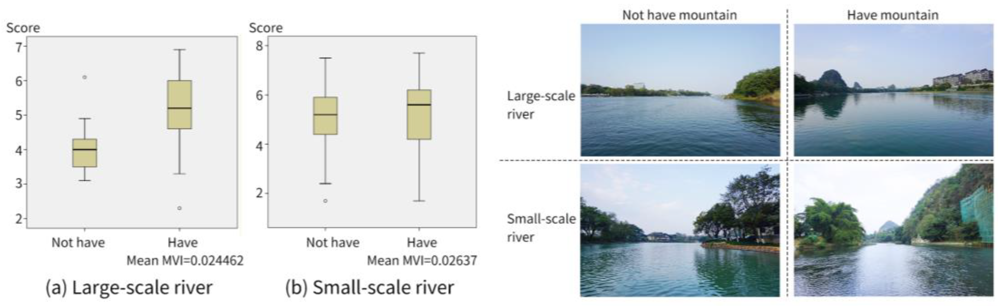
The MVI and DI indices were compared in order to further explore the influence of local characteristic landscapes (mountain) and visually destructive elements (abandoned sites and construction facilities) on the scores of rivers at different scales. Images with an indicator ≥0.0001 were defined as containing physical elements, while images with an indicator <0.0001 were defined as not containing physical elements. Box graphs were used to compare different river scales. For MVI and DI values <0.0001 in each scene are, the proportion of mountains, abandoned sites, and construction facilities in the image is very small, and the scene can be considered to visually lack mountain landscapes and construction facilities.
3. Results
3.1. Image Semantic Segmentation Results
After 100 epochs of UNet neural network training, the MIoU of the model reached 82.50%, and the Acc reached 95.25% (Table 3). It can be seen from the identification results in Figure 3 that the segmentation of various elements in the trained model is consistent with the actual situation, and the boundary lines of water, plants, buildings, sky and other elements are clearly divided, but there are some errors in the segmentation of mountains, which need to be corrected for a small part. The results reveal the high precision of the model, and it can thus be used for image processing.
3.2. Public Preference Survey Results
Table 4 reveals the average on-water landscape aesthetic quality scores for large- and small-scale rivers to be at the medium level (5.02 and 5.03, respectively). Moreover, the standard deviation (STD) values for large- and small-scale rivers are 1.05 and 1.22, respectively, indicating that the water landscape scores of different scenes in the group varies significantly. The water landscape quality differences in small-scale rivers are greater than those in large-scale rivers.
Figure 4 depicts the overall distribution of the on-water landscape quality scores. The score variations for large-scale rivers are generally minimal, and the continuity is high. There are two sections within the research scope of large-scale rivers with high overall scores. The first section is on the main river in the south of the research scope, and the second section is between the two wharfs on the Li River where an upstream line has been set up, but the score near the south wharf is low. For small-scale rivers, the landscape diversity with an interval of 100 m between adjacent scenes is strong, and the scores exhibit large changes. The score between the two wharfs that have opened the upstream water line is at a medium level, which is necessary to improve the landscape quality; in the south, there is a continuous point with high landscape quality between the two mountains; the points with low scores are mainly in the form of abrupt changes in small-scale rivers.
Following this, 20 images were randomly selected from 170 images, and the aesthetic quality score of each image was divided into two groups for t-tests. The results of the two groups of 20 images were not significantly different (p ≥ 0.05), and thus the influence of gender on the landscape quality score was not considered.
3.3. River Landscape Characteristics under Different Scales
All the landscape characteristics of rivers were observed to differ significantly at different scales, with the exception of VN (Table 4). The average values (AVG) of GVI, HRV, AID and DI in small-scale rivers were significantly higher than those of large-scale rivers, indicating that vegetation, revetments, buildings and bridges, abandoned sites and construction facilities accounted for a high proportion of visible water landscapes in small-scale rivers. The STD values of large- and small-scale river landscape features were high, indicating large differences in the landscape features of rivers of the same scale. The AVG of WVI, MVI, NVM, HC, VC and MU of large-scale rivers were significantly higher than those of small-scale rivers. This reveals that compared with small-scale rivers, large-scale rivers have the characteristics of visible water and mountains account for a higher proportion, the number of mountains is larger, the degree of skyline and mountain fluctuations is more obvious, and the landscape is richer. The high STD of MVI, NVM, HC, VC and MU indicates large changes in these landscape features under different scenes of the same scale. Moreover, the low STD of WVI indicates minimal differences in the blue field index across different scenes of the same scale.
3.4. Main Control Factors Affecting On-Water Landscape Quality
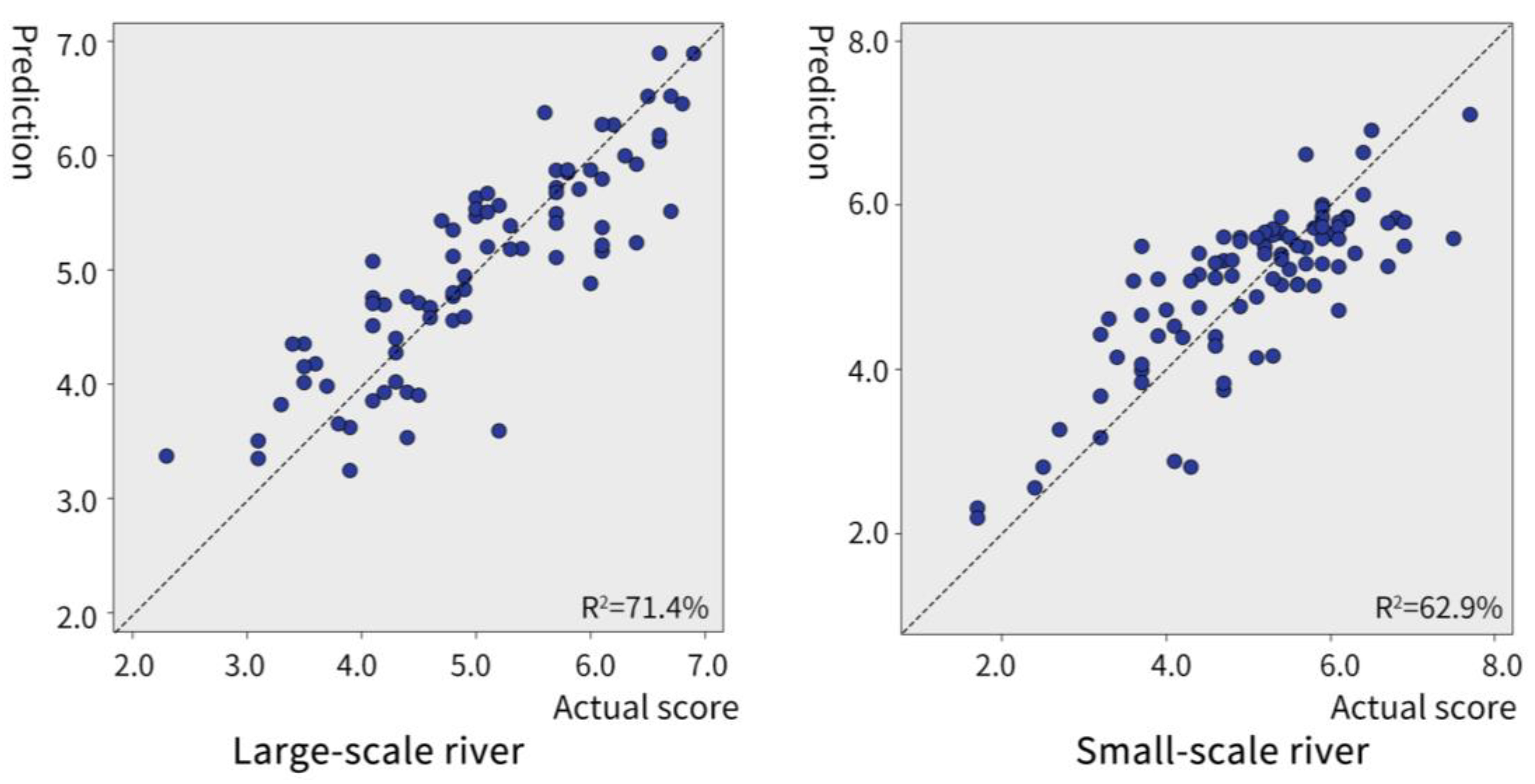
The best models were selected using automatic linear modeling. The adjusted R2 of the optimal model for large- and small-scale rivers is 71.4% and 62.9%, respectively. The regression model between the aquatic landscape feature system and the score at both scales (Figure 5) is highly accurate, and the selection of the main control factors is convincing.
The VN, GVI, HC, MU, VC, HRV and NVM are observed to exert a significant influence on the scores of large-scale rivers (Figure 6a). VN is the most important, followed by GVI. Factors with p < 0.05, namely, VN, GVI, HC and MU. VN, GVI and MU are positively correlated with the score, while HC is negatively correlated with the score (Figure 7a). DI, VN, MVI and GVI have significant effects in small-scale rivers (Figure 6b), with DI as the most important, followed by VN. p values for all four factors are <0.05. DI is negatively correlated with the score, while the remaining exhibit positive correlations (Figure 7b). It can be seen from Figure 7 that under different river scales, the natural degree of the scene and the proportion of plants have a positive impact on the quality of visual aesthetics. The mountains also have a positive impact on the aesthetic quality. For large-scale rivers, the impact of mountain undulation is strong, and for small-scale rivers, the impact of mountain proportion is strong.
The landscape quality of large-scale rivers impacts the main control factors, and with the exception of VN and GVI, all factors have a similar effect. The large-scale river comprehensive effect on the on-water landscape impact factor is stronger. The seven key controlling factors contain all four visual richness indices, two of which are significant (p < 0.05). This shows that visual richness and overall undulation rhythm have a stronger impact on large-scale river on-water landscapes compared to other visual richness indices.
There are four key factors influencing the water landscape quality of small-scale rivers, and the influence of each factor differs significantly. This indicates that the strong factors are dominant to the landscape quality. The four main controlling factors are all landscape vision proportion indicators, revealing the large impact of the proportion of different elements in small-scale rivers on the score, and individuals focus strong attention to the performance of landscape details.
3.5. Univariate Comparison of Influencing Factors
By comparing the average MVI values of the scenes with mountains under the two scales from Figure 8, it can be seen that the MVI values of the small and medium-sized rivers are slightly higher than those of the large-scale rivers, while the scene without mountains scores the small and medium-sized rivers significantly higher than the large-scale rivers. The existence of mountains has a significant positive impact on the landscape quality of large rivers, yet no significant impact on small rivers is observed. It can be seen that the Karst mountain landscape with local characteristics in Guilin has a better viewing effect in the large-scale river scene with relatively wide vision.
It can be seen from Figure 9 that the presence of abandoned sites and construction facilities has a significantly negative effect on the on-water landscape quality of small-scale rivers. However, there is little difference between the scores with and without it in large-scale rivers, and its influence on large-scale rivers is not obvious. In different river scales with abandoned sites and construction facilities, the scores of small-scale rivers are significantly lower than those of large-scale rivers.
4. Discussion
4.1. Influence Mechanism of Landscape Composition on Aesthetic Quality
The negative correlation between HC and score in large-scale rivers is attributed to towering cranes in construction facilities; construction facilities damage the visual quality of landscapes [31]. In addition, artificial skylines cause vertical rises and disrupt the continuous landscape expected by visitors. The positive correlation between MU and the score is related to the tourists’ expectations of the natural landscape. People are more likely to enjoy the urban landscape like a painting [42]. Although mountain undulations increase the HC value, they have a weak effect on the skyline relative to artificial facilities. The minimal fluctuation of mountains is consistent with the “Guilin Mountain and River Landscape” expected by visitors, and thus high MU values enhance the landscape quality scores.
VN, MVI and GVI values in rivers of different scales are positively correlated with the score and with people’s preferences for natural landscapes. Green plants are conducive to mood relief and relaxation, and increase the sense of pleasure [43,44]. VN has an important influence on the score, and its degree of influence is higher than that of GVI in small rivers. Compared with the preference for green landscapes in urban parks [45] and waterfront environments [46], attention to the overall natural degree of the environment increases during on-water sightseeing. Moreover, the effect of plants is weaker during on-water tours than with park and riverside environments. However, the effect of harmony among plants, sky, mountains and water is stronger.
The presence of mountains in small-scale rivers does not significantly increase the landscape water quality scores. The Karst landscape with local characteristics in Guilin exhibits a stronger viewing effect in large-scale river scenes with good sight effect. This can be attributed to the similarity between the on-water space scale and street space scale. Different proportions of the vertical element height and river width on both sides will generate distinct feelings in tourists. The higher the ratio of height to width, the stronger the sense of space closure and pressure [47]. On urban rivers, people prefer open spaces, and towering mountains increase the sense of pressure in small-scale rivers. In addition, the visual difference between mountain and plant landscapes is small in the near view, while the effect of the mountain form is well when the mountain is in the distance [48]. When visiting small spaces, we pay more attention to landscape details [49]. In small-scale rivers, due to the occlusion of plants and urban buildings on both sides of the river and the limitations of the space itself, the ability to view mountains from a distance is limited, and thus their effect on on-water landscape quality is limited.
Abandoned sites and construction facilities are known to have a destructive effect on visual quality. Their presence has a significant impact on the on-water landscape quality of small-scale rivers, but not large-scale rivers. This is because landscape satisfaction is highly correlated with the visual attractiveness of elements [50]. The average DI scores for large-scale rivers are lower than those for small-scale rivers. Destructive elements make up a very small visual proportion in the large-scale river on-water sightseeing, therefore they play only a minor role in damaging the landscape quality. For small-scale rivers, although abandoned sites and building facilities account for a small proportion in the water scene, destructive elements are rare and more noticeable in the water environment. Thus, they exert a strong impact on the landscape.
4.2. Improvement Strategies of On-Water Landscape Quality of Rivers at Different Scales
For the development and landscape improvement of urban rivers, the basic functions of ecological value must be met. The quality of landscape water must meet the fourth-class standard of surface water quality [51] in order to have a clean surface and ensure the continuity and stability of the urban blue-green system. Based on this, through the development of on-water tourism activities, the cultural service function of urban rivers will be further developed to increase the aesthetic, entertainment, cultural, artistic value, scientific and educational values. When improving the visual quality of urban on-water sightseeing, we should excavate natural landscapes (such as mountains) with local characteristics to improve the quality of public tourism and the regional characteristics of the landscape. Based on the research results of this paper, we put forward targeted planning and design schemes based on low-cost methods such as planting vegetation, artificial constructions and the micro regeneration for rivers of different scales.
In the on-water landscape reconstruction of large-scale rivers, the coordination of the landscape and the fluctuation and transition of landscape edge lines under large-scale scenes are emphasized. In particular, attention should be paid to the proportion of artificial elements, and the degree of visual naturalization and the ornamental nature of plants should be improved. This can include, for example, planting Guangxi native arbor species with tall trees, bright flowers or autumn leaves on the waterfront side, such as kapok (Bombax ceiba L.), flame tree (Delonix regia (Boj.) Raf.), maple (Acer spp.) and China fir (Cunninghamia lanceolata (Lamb.) Hook.). Such an approach not only shelters urban buildings, but also enhances the visual attraction of plants and reduces the impact of urban construction on the natural landscape. The existing municipal bridges on the tour route have been slightly renovated by trifoliate plants such as bougainvillaea (Bougainvillea glabra Choisy) to soften the visual effect of the bridge. Moreover, the continuity of the landscape should be strengthened by controlling the overall visual ups and downs of the landscape. This can include reducing the visibility of super high-rise and retreating high-rise buildings, leaving a buffer space between the city and river, and reducing the water skyline view. Medium and high-rise buildings should not be built around the mountain to protect its visual integrity. In addition, reduce the impact of construction facilities on the quality of water landscape by reducing riverside construction projects in the peak on-water tourism season.
In the reconstruction of small-scale rivers, the main task is to improve the proportion of the visual components and the quality of the visible elements. It is also important to ensure the cleanliness of the landscape and reduce the visibility of destructive elements. When taking a boat trip, an environment with more natural features can appeal to people, yet a scenic value does negate the value of human influence [52]. When developing the visual ratio of natural landscapes, we should pay attention to enhancing the visual effect of artificial elements, for example, improving the material and color of building facades. White, gray and brown are commonly used in Guangxi traditional folk houses [53] and are the main colors of riverside building facades, while bamboo and imitation bamboo materials are used for micro renewal. To reduce the sense of visual violation, existing flat roof buildings will be renewed by adding the second slope roof on the top of the flat roof, imitating traditional roof forms such as overhanging gable roofs or round ridge roofs. Small-scale river revetments should be treated as near-natural, for example stacked with block stones or stone paving to soften the visual transition between vertical and horizontal interfaces. With the aim of not having an impact on sailing, appropriate amounts of aquatic plants should be planted at the water edge to increase the proportion of green plants and improve the sense of hierarchy and richness.
In addition, government departments should formulate corresponding public policies to guide the selection of on-water routes from the urban planning and development level and the improvement of water landscapes from the design level. This will aid in the improvement and development of water landscapes in other cities.
5. Conclusions
In this paper, image semantic segmentation technology was used to segment the on-water image, and it showed that the on-water landscape characteristics of different river scales exhibited obvious variations. The automatic linear model is used to establish the relationship between the public’s evaluation of the visual aesthetic quality of the on-water sightseeing landscape and the landscape feature system at different river scales. For large-scale river on-water sightseeing, the landscape quality was mainly influenced by environmental naturalness, the visual proportion of vegetation, and visual landscape richness. The Guilin characteristic Karst landform greatly improved the visual satisfaction of the public during large-scale river on-water tours. For small-scale rivers, the landscape quality was generally influenced by the proportion of destructive elements, environmental naturalness, mountain visibility and vegetation visual proportion.
At this stage, this research has the following shortcomings: (1) the limitations of photo perspective. This study was carried out from a perspective parallel to the river, without looking at the river bank. In subsequent research, the on-water landscape research will be carried out in four directions: front and back, left and right; (2) in this research, landscape features were extracted from the physical composition features of the image. In subsequent research, we could continue to deeply explore on other visual influencing factors, such as color in similar landscape features.
The development and landscape improvement of on-water sightseeing routes not only enhances the ecological value of urban rivers, but also improves the corresponding cultural service function. The continuity of the natural landscape and the changes of the elements of landscape composition are key to improving the on-water landscape of large-scale rivers. For small-scale rivers, the cleanliness of the landscape, the enhancement of the natural element proportion, and the improvement of the landscape quality of artificial elements are crucial factors to improve the on-water landscape of small-scale rivers.
Author Contributions
Conceptualization, X.L. and X.W.; methodology, X.L. and Q.L.; software, X.L.; validation, D.W. and X.W.; formal analysis, X.L.; investigation, X.L.; resources, D.W.; data curation, X.L.; writing—original draft preparation, X.L.; writing—review and editing, X.L. and J.H.; visualization, D.W., J.Z. and S.Z.; supervision, Q.L. and X.W.; project administration, Q.L.; funding acquisition, X.W. All authors have read and agreed to the published version of the manuscript.
Funding
This work was supported by the “Major Issues of the Land and Space Planning System of the Land and Space Planning Bureau of the Ministry of Natural Resources of the People’s Republic of China” (TC2101050/10).
Institutional Review Board Statement
Not applicable.
Informed Consent Statement
Not applicable.
Data Availability Statement
All processed data used in the study are shown in the article.
Conflicts of Interest
The authors declare no conflict of interest.
References
- Huang, T.; Wei, X.D. Study on the comprehensive development of water tourism in urban river landscape belt—A case study on the development of Suzhou ancient city river. China Water Transp. (Second. Half) 2008, 3, 216–218. [Google Scholar] [CrossRef]
- Lu, Y.M.; Wu, B.F.; Yan, N.N.; Zeng, H.W.; Guo, Y.; Zhu, W.W.; Zhang, H. Method for monitoring environmental flows with high spatial and temporal resolution satellite data. Environ. Monit. Assess. 2022, 13, 194. [Google Scholar] [CrossRef] [PubMed]
- Lu, C.Y.; Ren, C.Y.; Wang, Z.M.; Wang, Z.M.; Zhang, B.; Man, W.D.; Yu, H.; Gao, Y.B.; Liu, M.Y. Monitoring and assessment of wetland loss and fragmentation in the cross-boundary protected area: A case study of wusuli river basin. Remote Sens. 2019, 11, 2581. [Google Scholar] [CrossRef] [Green Version]
- Musaoglu, N.; Seker, D.Z.; Kabdasli, S.; Kaya, S.; Duran, Z. Using remote sensing and GIS for the assessment of visual attributes: A case study of the south coastal zone of Turkey. Fresenius Environ. Bull. 2004, 13, 854–859. [Google Scholar] [CrossRef]
- Liang, T.; Zhu, J.H.; Xu, G.; Li, R.D.; Ke, X.; Ma, Y.F.; Wen, D. Application of benthic index of biotic integrity UAV remote sensing technology to assess ecosystem health of upstream section of Liaohe River. Environ. Res. 2014, 27, 1134–1142. [Google Scholar] [CrossRef]
- Zhong, Y.J.; Huo, D.; Wu, D.Z. Review of Chinese urban river regeneration projects in the early 21st century. Landsc. Archit. 2020, 27, 24–28. [Google Scholar] [CrossRef]
- Kane, P.S. Assessing landscape attractiveness: A comparative test of two new methods. Appl. Geogr. 1981, 1, 77–96. [Google Scholar] [CrossRef]
- Velarde, M.D.; Fry, G.; Tveit, M. Health effects of viewing landscapes landscape types in environmental psychology. Urban For. Urban Gree. 2007, 6, 199–212. [Google Scholar] [CrossRef]
- Daniel, T.C. Whither scenic beauty? Visual landscape quality assessment in the 21st century. Landsc. Urban Plan. 2001, 54, 267–281. [Google Scholar] [CrossRef]
- Hagerhall, C.M.; Sang, A.O.; Englund, J.E.; Ahlner, F.; Rybka, K.; Huber, J.; Burenhult, N. Do humans really prefer semi-open natural landscapes? A cross-cultural reappraisal. Front. Psychol. 2018, 9, 822. [Google Scholar] [CrossRef]
- Gong, L.; Wan, X.H.; Wang, M.; Zhao, W.L.; Zhou, B. Analysis of waterfront green space landscape characteristics based on SBE method——Taking South Lake of Yueyang City as an example. J. Hunan Inst. Sci. Technol. (Nat. Sc.) 2019, 32, 52–58. [Google Scholar] [CrossRef]
- Clay, G.R.; Danie, T.C. Scenic landscape assessment: The effects of land management jurisdiction on public perception of scenic beauty. Landsc. Urban Plan. 2000, 49, 1–13. [Google Scholar] [CrossRef]
- Bulut, Z.; Yilmaz, H. Determination of waterscape beauties through visual quality assessment method. Environ. Monit. Assess. 2009, 154, 459–468. [Google Scholar] [CrossRef] [PubMed]
- Li, X.; Wu, D.Z.; Li, L.; Wang, X.R. Research on visual perception evaluation of urban riverside greenway landscape based on deep learning. J. Beijing For. Univ. 2021, 43, 93–104. [Google Scholar]
- Liu, J.X.; Peng, T.; Liu, H.; He, Y.Q.; Shi, X.J.; Zeng, J.Y.; Deng, C.Y. Visual evaluation of landscape of the compound green space on the east bank of Wulong River based on public perception. J. Northwest For. Univ. 2021, 36, 258–265. [Google Scholar] [CrossRef]
- Yao, Y.M.; Zhu, X.D.; Xu, Y.B.; Yang, H.Y.; Sun, X. Assessing the visual quality of urban waterfront landscapes:the case of Hefei, China. Acta Ecol. Sin. 2012, 32, 5836–5845. [Google Scholar]
- Rafi, Z.N.; Kazemi, F.; Tehranifar, A. Public preferences toward water-wise landscape design in a summer season. Urban For. Urban Gree. 2019, 48, 126563. [Google Scholar] [CrossRef]
- Li, X.; Wang, X.R.; Jiang, X.; Han, J.Y.; Wang, Z.Y.; Wu, D.Z.; Lin, Q.; Li, L.; Zhang, S.Y.; Dong, Y. Prediction of riverside greenway landscape aesthetic quality of urban canalized rivers using environmental modeling. J. Clean. Prod. 2022, 367, 133066. [Google Scholar] [CrossRef]
- Cui, Q.Y.; Huang, Y.T.; Yang, G.; Chen, Y. Measuring Green Exposure Levels in Communities of Different Economic Levels at Different Completion Periods: Through the Lens of Social Equity. Int. J. Environ. Res. Public Health 2022, 19, 9611. [Google Scholar] [CrossRef]
- Zhao, L.; Wang, H.L.; Ding, G.W.; Zhang, Y. Study on the quantitative evaluation of visual spatial interface in mountain area facing the lake—Illustrated by the case of Jinan Foshan inverted image. Chin. Landsc. Archit. 2021, 37, 50–55. [Google Scholar] [CrossRef]
- Wang, L.; Han, X.; He, J.; Jung, T. Measuring residents’ perceptions of city streets to inform better street planning through deep learning and space syntax. ISPRS J. Photogramm. Remote Sens. 2022, 190, 215–230. [Google Scholar] [CrossRef]
- Sun, R.H.; Li, F.; Chen, L.D. A demand index for recreational ecosystem services associated with urban parks in Beijing, China. J. Environ. Manag. 2019, 251, 109621. [Google Scholar] [CrossRef]
- Zhou, X.J.; Zheng, Y.Z. Three Gorges tourist satisfaction influencing factors and brand loyalty test. Stat. Decis. 2016, 18, 182–184. [Google Scholar] [CrossRef]
- Cavalheiro, M.B.; Mayer, V.F.; Luz, A.B.T.; Queiroz Neto, A.C. Nautical sports tourism: An exploratory analysis on opportunities for future development. Tur. Visão e Ação 2022, 24, 195–218. [Google Scholar] [CrossRef]
- Gao, S. Suggestions on promoting the construction and development of water tourism transportation in China. China Water Transp. 2020, 9, 12–14. [Google Scholar] [CrossRef]
- Wu, Y.Y. Investigation and analysis on Wuxi aquatic tourism and countermeasures study from the perspective of tourists. J. Anhui Agric. Sci. 2011, 39, 22429–22431. [Google Scholar] [CrossRef]
- Shyu, G.S.; Fang, W.T.; Cheng, B.Y. Recreation and Tourism Service Systems Featuring High Riverbanks in Taiwan. Water 2020, 12, 2479. [Google Scholar] [CrossRef]
- Li, R. Current situation and Enlightenment of European inland cruise tourism market. Water Trans. Manag. 2019, 41, 31–32. [Google Scholar] [CrossRef]
- Wartmann, F.M.; Tieskens, K.F.; van Zanten, B.T.; Verburg, P.H. Exploring tranquillity experienced in landscapes based on social media. Appl. Geogr. 2019, 113, 102112. [Google Scholar] [CrossRef]
- Zhang, C.; Lin, Z.L. Research on the development status and Countermeasures of water tourism in China. Inq. Into Econ. Issues 2009, 6, 121–125. [Google Scholar]
- Li, X.; Li, L.; Wang, X.R.; Lin, Q.; Wu, D.Z.; Dong, Y.; Han, S. Visual quality evaluation model of an urban river landscape based on random forest. Ecol. Indic. 2021, 133, 108381. [Google Scholar] [CrossRef]
- Liu, Y.; Yang, S.T.; Wang, S.J. Heterogeneity study of the visual features based on geographically weighted principal components analysis applied to an urban community. Sustainability 2021, 13, 13488. [Google Scholar] [CrossRef]
- Zheng, W.J. On Ship-taking tourists’ expectation and perception of Li-river’s landscape. China Popul. Resour. Environ. 2013, 23, 143–148. [Google Scholar]
- Hansen, A.; Cox, J.R. The Routledge Handbook of Environment and Communication (Routledge Handbooks); Routledge: London, UK; New York, NY, USA, 2015. [Google Scholar]
- Fan, K.X. Sociological Quantitative Method, 1st ed.Nanjing University Press: Nanjing, China, 2004. [Google Scholar]
- Sullivan, G.M.; Artino, A.R. Analyzing and interpreting data from likert-type scales. J. Grad. Med. Educ. 2013, 5, 541–542. [Google Scholar] [CrossRef] [Green Version]
- Norman, G. Likert scales, levels of measurement and the ‘‘laws’’ of statistics. Adv. Health Sci. Educ. 2010, 15, 625–632. [Google Scholar] [CrossRef]
- Ronneberger, O.; Fischer, P.; Brox, T. U-Net: Convolutional Networks for Biomedical Image Segmentation; MICCAI 2015; LNCS; Springer: Cham, Switzerland, 2015; pp. 234–241. [Google Scholar] [CrossRef] [Green Version]
- Zhang, W.; Tang, P.; Zhao, L.; Huang, Q. A Comparative Study of U-Nets with Various Convolution Components for Building Extraction. In Proceedings of the 2019 JURSE, Vannes, France, 22–24 May 2019; pp. 1–4. [Google Scholar] [CrossRef]
- Li, M.M.; Stein, A. Mapping land use from high resolution satellite images by exploiting the spatial arrangement of land cover objects. Remote Sens. 2020, 12, 4158. [Google Scholar] [CrossRef]
- Qian, J.; Wang, Y.B. Application comparison of several statistical software to build ARIMA model. Stat. Decis. 2018, 34, 80–84. [Google Scholar] [CrossRef]
- Wang, X.R.; Lin, Q. Traditional Chinese mountain-water-field-city system from the perspective of territorial landscape. Landsc. Archit. 2018, 25, 10–20. [Google Scholar] [CrossRef]
- Li, X.; Wang, Z.Y.; Wu, D.Z.; Tan, L.; Lin, Q. Research on pressure relief of young people by urban waterfront trail based on physiological feedback. Chin. Landsc. Archit. 2022, 38, 86–91. [Google Scholar] [CrossRef]
- Jeong, J.E.; Park, S.A. Physiological and psychological effects of visual stimulation with green plant types. Int. J. Environ. Res. Public Health 2021, 18, 12932. [Google Scholar] [CrossRef]
- Nordh, H.; Stby, K. Pocket parks for people—A study of park design and Use. Urban For. Urban Gree. 2013, 12, 12–17. [Google Scholar] [CrossRef]
- Sun, D.; Li, Q.Y.; Gao, W.J.; Huang, G.H.; Tang, N.; Lyu, M.; Yu, Y.Q. On the relation between visual quality and landscape characteristics: A case study application to the waterfront linear parks in Shenyang, China. Environ. Res. Commun. 2021, 3, 115013. [Google Scholar] [CrossRef]
- Zarghami, E.; Karimimoshaver, M.; Ghanbaran, A.; SaadatiVaghar, P. Assessing the oppressive impact of the form of tall buildings on citizens: Height, width, and height-to-width ratio. Environ. Impact Assess. Rev. 2019, 79, 106287. [Google Scholar] [CrossRef]
- Chen, W.X. The Spatial Construction Logic of Lingnan Gardens in the Perspective of the Landscape Painting. Ph.D. Thesis, South China University of Technology, Guangzhou, China, 2019. [Google Scholar] [CrossRef]
- Tang, J.X.; Long, Y. Measuring visual quality of street space and its temporal variation: Methodology and its application in the Hutong area in Beijing. Landsc. Urban Plan. 2019, 191, 103436. [Google Scholar] [CrossRef]
- Jeon, J.Y.; Jo, H.I. Effects of audio-visual interactions on soundscape and landscape perception and their influence on satisfaction with the urban environment. Build. Environ. 2020, 169, 106544. [Google Scholar] [CrossRef]
- GB 3838-2002; Environmental Quality Standard for Surface Water of the People’s Republic of China. Available online: https://www.mee.gov.cn/ywgz/fgbz/bz/bzwb/shjbh/shjzlbz/200206/W020061027509896672057.pdf (accessed on 26 September 2022).
- Dalton, T.; Thompson, R. Recreational boaters’ perceptions of scenic value in Rhode Island coastal waters. Ocean Coast. Manag. 2013, 71, 99–107. [Google Scholar] [CrossRef]
- Lei, X. Guangxi Folk Houses; Guangxi Nationalities Press: Guangxi, China, 2015. [Google Scholar]
Figure 1.
Study area location.

Figure 2.
Location of the shooting point.

Figure 3.
UNet image semantic segmentation.

Figure 4.
Aesthetic quality score of numerous scenes of rivers with different scales.

Figure 5.
Distribution of the model-predicted values.

Figure 6.
Importance of landscape characteristics on landscape quality at different river scales.

Figure 7.
Correlation between each influence factor and score.

Figure 8.
Aesthetic quality of the presence of mountains under different river scales.

Figure 9.
Aesthetic quality of the presence of abandoned sites and construction facilities under different river scales.
Figure 9.
Aesthetic quality of the presence of abandoned sites and construction facilities under different river scales.


Table 1.
Participant information statistics.
| Entry | Male | Female | All |
|---|---|---|---|
| Number | 108 | 137 | 245 |
| Percentage | 44% | 56% | 100% |
| Average age | 25.5 | 29.3 | 27.6 |
| Age standard deviation | 7.8 | 11.3 | 9.9 |
Table 2.
On-water landscape characteristic system.
| Category | Index Item | Instructions | Formula |
|---|---|---|---|
| Visual landscape proportion | Green visual index, GVI | Proportion of plants in the full image | |
| Water visual index, WVI | Proportion of water bodies in the full image | ||
| Hard revetment visibility, HRV | Proportion of revetment in the full image | ||
| Artificial influence degree, AID | Proportion of buildings and bridges in the full image | ||
| Destructive index, DI | Proportion of abandoned sites and construction facilities in the full image | ||
| Visual naturalness, VN | Proportion of plants, sky, water, and mountains in the full image | ||
| Mountain visual index, MVI | Proportion of mountains in the full image | ||
| Visual landscape richness | Number of visible mountains, NVM | Number of mountains visible in the full image | - |
| Horizontal complexity, HC | The skyline length | - | |
| Vertical complexity, VC | Plant line, building line, mountain line, and shoreline lengths | ||
| Mountain undulation, MU | Pixel size of the visible upper edge of the mountain | - |
Where is the ith images, , , , , , and denote the number of plant, water, revetment, building, bridge, sky and mountains in the images; represents the number of pixels in the whole image, and represents the number of pixels of the upper edge line length of plants, buildings, mountains and revetment in the image, with the line width of 1 pixel.
Table 3.
UNet training accuracy.
| Epoch | Acc (%) | MIoU (%) |
|---|---|---|
| 20 | 90.3885 | 71.7997 |
| 40 | 92.7365 | 76.4544 |
| 60 | 94.2221 | 80.5594 |
| 80 | 94.9267 | 81.5062 |
| 100 | 95.2519 | 82.499 |
Table 4.
Statistics of landscape characteristics at different river scales.
| Type | Score | GVI | WVI | HRV | AID | DI | VN | MVI | NVM | HC | VC | MU | |
|---|---|---|---|---|---|---|---|---|---|---|---|---|---|
| Large scale | AVG | 5.01772 | 0.07157 | 0.42304 | 0.00937 | 0.02812 | 0.00171 | 0.96041 | 0.01996 | 1.54430 | 25,035.35568 | 2,858,726.796 | 8235.785 |
| STD | 1.05439 | 0.03178 | 0.04344 | 0.00950 | 0.04258 | 0.00536 | 0.04496 | 0.03309 | 1.20679 | 6743.56479 | 770,031.375 | 7426.490 | |
| Small scale | AVG | 5.03077 | 0.23105 | 0.37113 | 0.03679 | 0.04729 | 0.00736 | 0.90794 | 0.00547 | 0.27473 | 6887.28600 | 786,442.500 | 1664.286 |
| STD | 1.21990 | 0.11120 | 0.03975 | 0.02758 | 0.07222 | 0.02659 | 0.07745 | 0.02203 | 0.66777 | 5131.49900 | 585,953.500 | 4542.005 | |
Publisher’s Note: MDPI stays neutral with regard to jurisdictional claims in published maps and institutional affiliations. |
© 2022 by the authors. Licensee MDPI, Basel, Switzerland. This article is an open access article distributed under the terms and conditions of the Creative Commons Attribution (CC BY) license (https://creativecommons.org/licenses/by/4.0/).
Share and Cite
MDPI and ACS Style
Li, X.; Wang, X.; Han, J.; Wu, D.; Lin, Q.; Zhou, J.; Zhao, S. Effects of River Scale on the Aesthetic Quality of Urban On-Water Sightseeing. Sustainability 2022, 14, 12543. https://0-doi-org.brum.beds.ac.uk/10.3390/su141912543
AMA Style
Li X, Wang X, Han J, Wu D, Lin Q, Zhou J, Zhao S. Effects of River Scale on the Aesthetic Quality of Urban On-Water Sightseeing. Sustainability. 2022; 14(19):12543. https://0-doi-org.brum.beds.ac.uk/10.3390/su141912543
Chicago/Turabian StyleLi, Xin, Xiangrong Wang, Jingyi Han, Danzi Wu, Qing Lin, Jiayi Zhou, and Shujie Zhao. 2022. "Effects of River Scale on the Aesthetic Quality of Urban On-Water Sightseeing" Sustainability 14, no. 19: 12543. https://0-doi-org.brum.beds.ac.uk/10.3390/su141912543
Note that from the first issue of 2016, this journal uses article numbers instead of page numbers. See further details here.