
Current Trends in Urban Heritage Conservation: Medieval Historic Arab City Centers


Department of Islamic Architecture, Umm Al-Qura University, Makkah al-Mukarramah 24382, Saudi Arabia
Sustainability 2022, 14(2), 607; https://0-doi-org.brum.beds.ac.uk/10.3390/su14020607
Submission received: 30 November 2021
/
Revised: 16 December 2021
/
Accepted: 17 December 2021
/
Published: 6 January 2022
(This article belongs to the Special Issue Appropriate Wisdom, Technology, and Management toward Environmental Sustainability for Development)
Abstract
:Traditional conservation efforts did not improve the conditions in most historic urban centers of Arab cities. The internationally adopted shift in historic urban conservation grants better urban vitality and sustainability for these areas. This study investigates the existing trends and forthcoming changes in urban conservation and their implication on historical centers. Urban Heritage Conservation UHC trends were reviewed, conservation parameters were defined, and quality aspects of successful historic urban conservation were identified, and an assessment framework was developed to evaluate the resulting conserved urban heritage. Two case studies of Arab cities, Jeddah and Aman, were analyzed. The findings highlight the most common urban issues such as reusing historic buildings, traffic congestion, and lack of funds. The impact of urban management on historic areas’ quality was revealed. Moreover, the paper ends with recommendations for conservation authorities. These include engaging residents in the conservation efforts, adopting more innovative traffic solutions to ease congestions, turning the historic area into a pedestrian-friendly space, attracting visitors through arranging cultural events, creating new job opportunities through heritage, and improving the image of the areas through urban regulations. The paper’s findings would contribute to the knowledge related to Urban Heritage Conservation (UHC), and its recommendations would help practitioners and decision-makers.

1. Introduction
No matter how old the urban heritage is, historical urban areas are considered an essential part of the local culture, a crucial base for cultural tourism, and local society prosperity [1]. It is an integral part of the collective memory of the local communities. Any development project of such urban areas should carefully consider the symbology of the urban fabric and its surrounding buildings [2]. Heritage definition, along with the conservation and restoration scope of monuments and sites, evolved since the 1964 Venice charter. There has been a shift among international organizations and conservation authorities to consider heritage as urban areas rather than a single monument. This shift is accompanied by increasing efforts toward engaging the local communities in preserving, managing, and controlling urban conservation plans [2].
From 2003 to 2019, UNESCO and ICOMOS made continuous efforts to revise the heritage definition and scope besides executing the conservation activities according to more sustainable approaches [3,4,5]. In parallel, The Seventeen Sustainable Development Goals (SDG), adopted anonymously by member states of the United Nations, repeatedly mention cultural aspects as the base for sustainable urban development. Moreover, the adopted Urban Agenda of the United Nations as of 2016 acknowledges tangible and intangible heritage as a critical parameter in developing sustainable urban economies to transition towards higher productivity [6].
Urban characteristics result from socio-cultural aspects such as values and traditions; environmental conditions such as climate and geographical location; and technological factors such as materials, economics, and construction technology, contribute to the physical form and architectural details [6]. Historic cities’ traditional built environments reflect local community values in their urban composition and spatial arrangement.
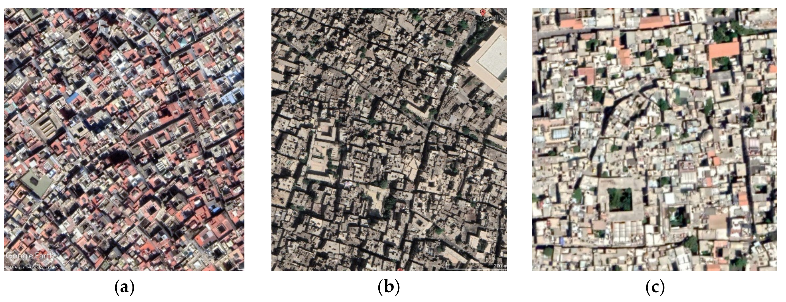
Despite the differences in climate, geographical location, and topography, similarities in historic Arab cities resulted from sharing the same socio-cultural characteristics, governing religious roles, and local construction materials and systems [7]. It should be noted that the urban morphology of these historic cities is impacted by the social aspects of private life rather than their geometric forms [8]. The urban fabric of Arab historical centers is a solid-built mass on which courtyards and narrow passageways are engraved [9]. These compact urban fabric, narrow shaded street networks, and buildings’ protected openings were environmental and social responses [10]. The satellite image in Figure 1 illustrates the shared urban characteristics of three different cities, Rabat, Cairo, and Damascus, in terms of inner-oriented buildings with courtyards and narrow irregular-shaded pedestrian networks.
Traditional conservation efforts for historical centers were neither successful nor sustainable in most of these centers for many reasons, such as a lack of funds, unsuitable urban management policies, and the narrow scope of development projects. Therefore, this paper investigates the existing trends in conservation and the forthcoming changes in urban heritage conservation approaches, and their implications on the historic urban city centers in Arab cities. This paper is structured in five main sections. Following the introduction, the literature review highlights the Arab historical centers in terms of their urban characteristics, threats, and problems. The third section presents the theoretical Background and Contextual Approach that discusses the international trends in historic urban landscape conservation. The fourth section is the methodology and assessment framework that presents the main aspects of saucerful conservation, the main success indicators, and the UHC assessment framework. In the fifth section, two historical centers of Arab case study cities were introduced and analyzed, and the resulting urban heritage was assessed. The sixth section discusses the research findings and presents the final recommendations. The seventh section concludes the research outcomes while highlighting the research limitation and its future extensions.
2. Literature Review: Arab Historic City Centers
2.1. Characteristics of Arab Historic City Centers
The medieval urban fabric was built inward, where every level of its components is contained, from its gated city walls to its quarters and local residential clusters. Even central public spaces are tightly confined. Main streets lead to local, extremely narrow cul-de-sacs, which lead by tight, dog-leg corridors to private patios. Public open spaces are enclosed by shop fronts or solid walls of the houses and gardens [6]. Narrow dead-end alleys lead pedestrians from public spaces to semi-public and semi-private circulation spaces. Most urban traffic serves areas for commercial and religious purposes, and city gates use main walkways. Streets are sided by many blind facades, while outside openings are covered with wooden curtains on the upper floors [11]. Historic urban areas have two types of public spaces. The first is the open public space appearing in open plazas in front of key buildings such as the mosque, market, and school. The second type is the traffic streets, represented by the narrow-structured pattern of vehicular pedestrian-oriented alleys [4]. The narrow streets “were a traffic control system that effectively arranged different urban functions [12]. The “Friday prayer” courtyard acts as a gathering space [11].
In contrast, the plaza in front of the grand mosque and other public buildings serves as circulation distribution nodes to and from the lower category neighboring paths. A wider space often appeared along the central path spine of the fabric. The size of this space depended on its location within the urban fabric and its accommodated pedestrian traffic [8]. Physical borders are loosened in those spaces and extend the bazaar to accommodate the informal commercial and social activity. Urban heritage researchers indicated a typical unwritten relationship between the width of streets and their bounding buildings’ heights [12]. The main feature of the city’s land use is the clear separation of commercial from residential areas. All markets are within the central zone, and the city’s central urban area is distinctive by its relatively large, straight streets leading directly to the old main gates [10].
In historic Arab cities, there has been a significant contrast between commercial crowded streets and the quiet calm of the private courtyards [6]. The network structure of the open spaces is based on controlling access and mobility, and doors were used to manage social contact, even in streets where no entries were allowed to open in front of another [13]. Moreover, the courtyard concept is crucial, utilizing open space surrounded by private usage. The effective use of courtyards allows narrow lanes and interrupts perspectival alignments [11].
2.2. Endangered Arab Historic City Centers
Urban settlements evolve and change to fulfill their inhabitants’ requirements. Over the past century, historic city centers have struggled between their symbolic significance as heritage with a distinctive sense of place and many political and economic development programs [11]. The historical city centers’ “Albalad” areas accommodated the city’s central markets, wholesale shops, and traditional crafts [14]. The historic urban centers are not isolated individual areas. Areas surrounding historic centers constitute an interface between the historic center and other city districts and complement its character [15]. These districts adopt the same urban identity. Over the course of time, climate and religion have lost their influence over historical cities and their urban character. Inspired by aspirations of modernity, following the lead of western globalization and the impact of the powerful private corporations, cities enforced certain practices, spaces, and forms on their traditional urban fabric [16]. The requirements of everyday life coupled with economic growth had a destructive impact on the urban heritage of the historic centers of Middle Eastern cities [7]. The physical characteristics of open spaces have changed, but they still follow the same traditional socio-cultural structure.
The modernization shift in Arab cities’ urban form, architecture, and housing started with the beginning of the railway transportation systems in the early nineteenth century linking the region to European cities. This system had a significant role in modernizing many Arab cities such as Mosul, Amman, Cairo, Alexandria, and Damascus. Consequently, it creates an interactive, diverse environment for people from diverse ethnic and religious groups, and opportunities for various commercial activities [17,18]. The modern grid pattern forms the most common type of urban fabric in Arab cities of the nineteenth century, where residence units vary between row-house, semi-detached, and detached villas. These units are distributed on a regular grid pattern with horizontal and vertical streets. The new type followed in the expansion of districts away from the historic center districts [17].
Analyzing tangible and intangible factors that affected the Arab cities’ transition between the medieval and early twentieth centuries reveals that the transformation was a gradual shift from a harmonious pedestrian-oriented built environment into a fragmented vehicular-oriented environment [19,20].
2.3. Urban Problems of Arab Historic Centers
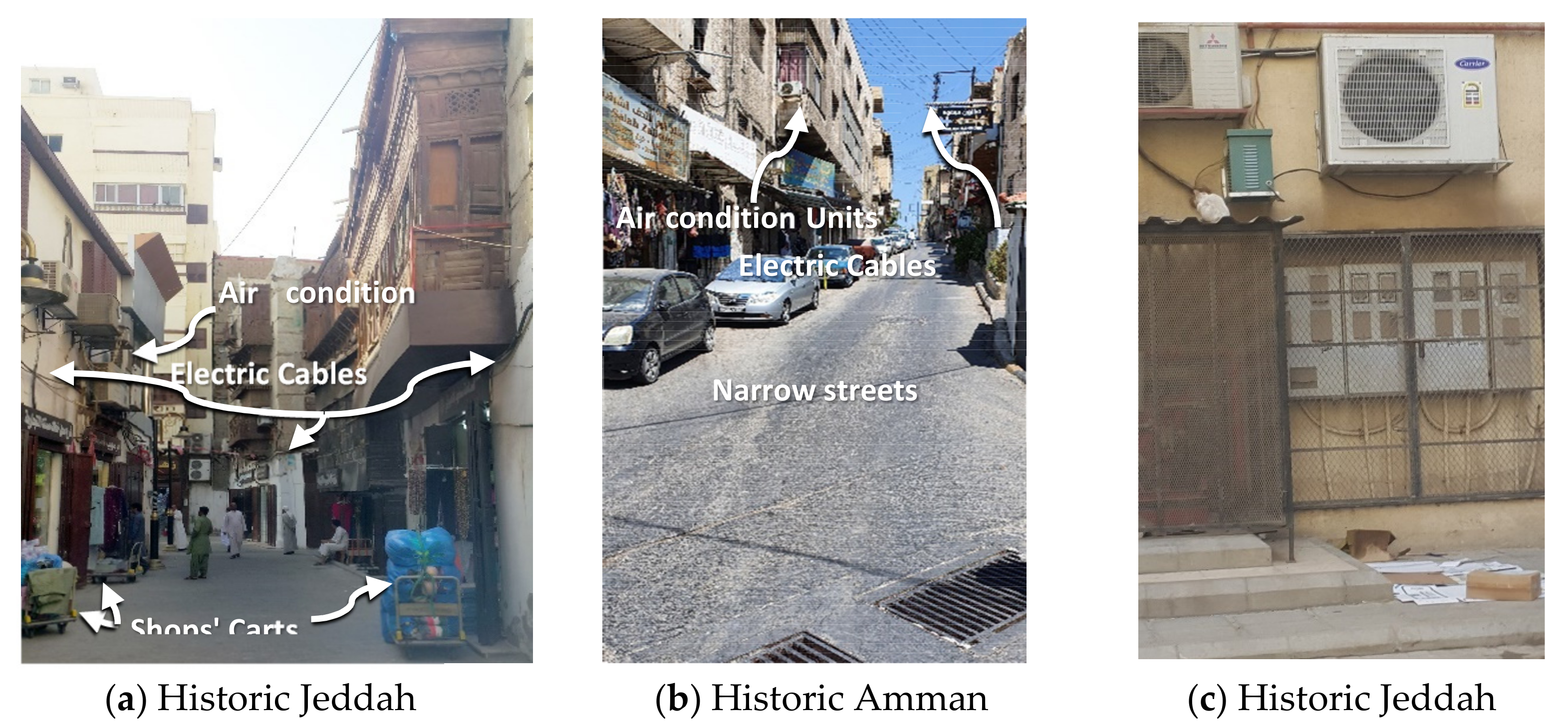
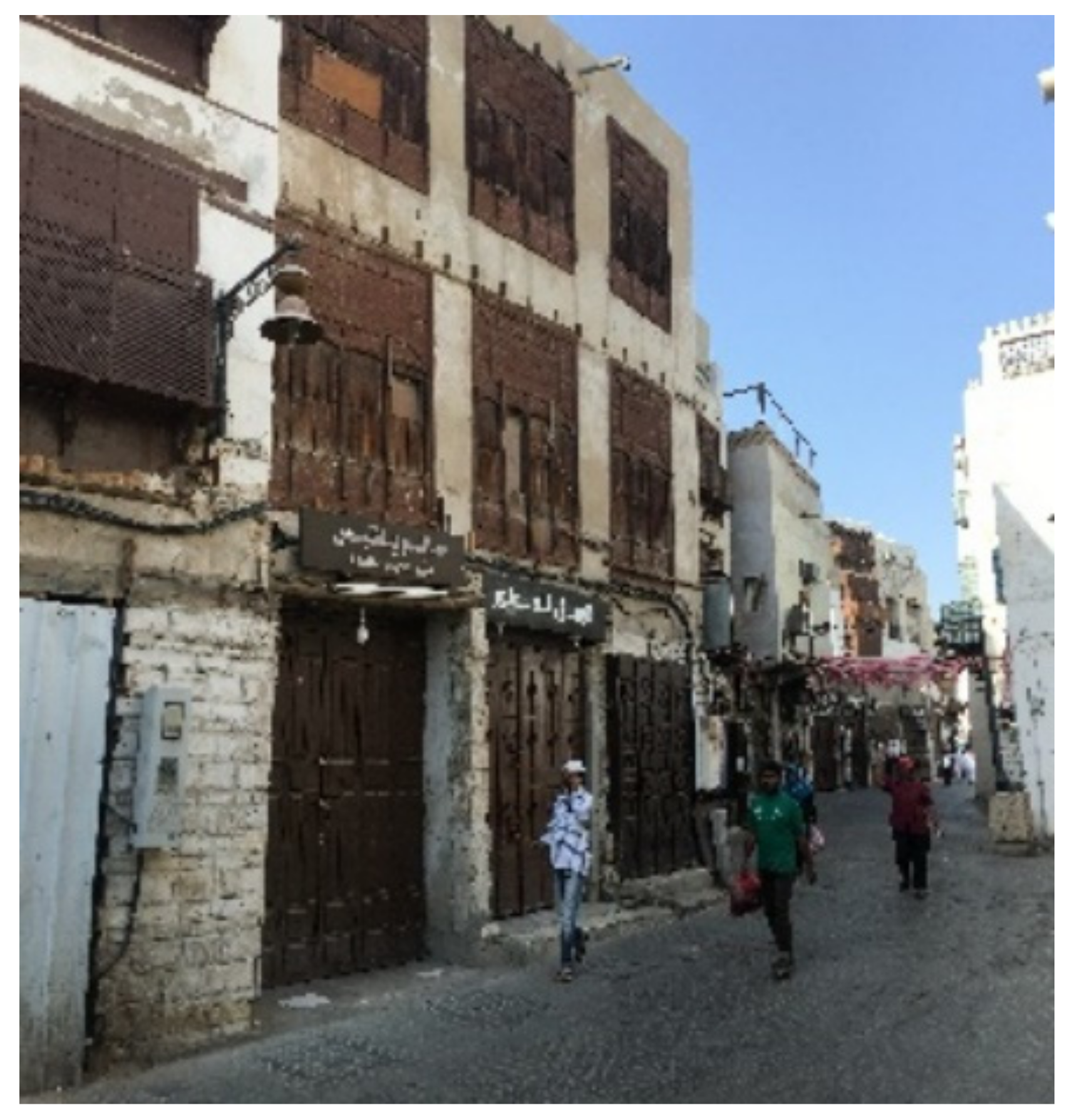
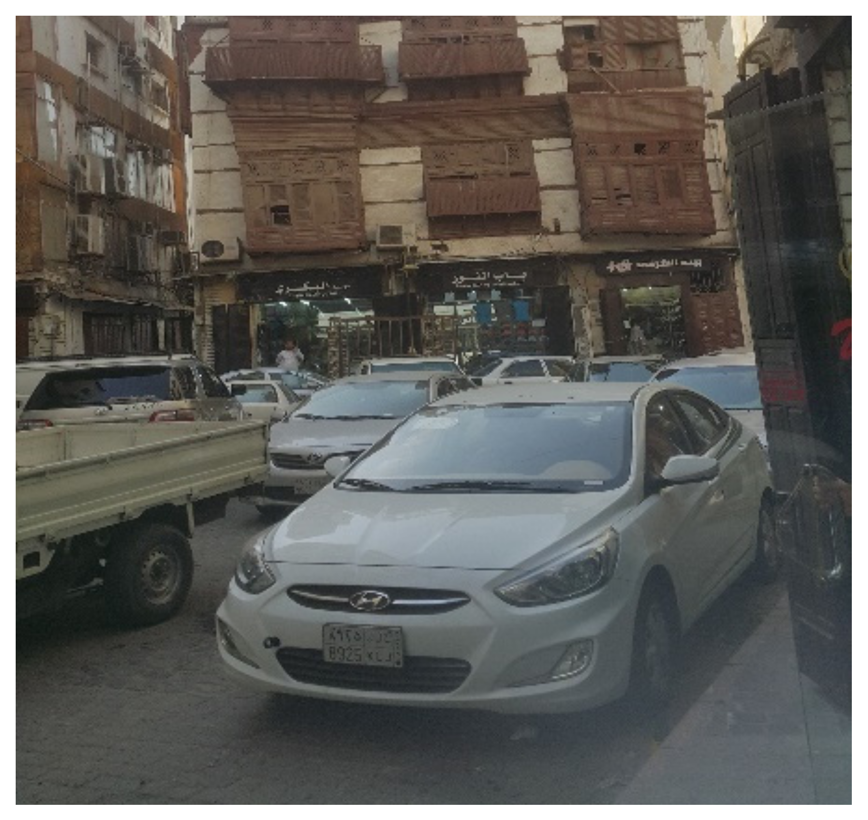
Historic centers within Arab cities have something in common; they are all about to lose their historical identity and urban character. Many researchers have identified more problems related to the urban changes of historical centers [8]. In addition to the previously mentioned impact of railways in cities’ modernization during the ninth century, the car has had significantly impacted city planning through the last century [21]. In the case of Arab cities, what was once a pedestrian-friendly traffic network has had to accommodate a vehicular-based traffic system. During this transition, economic, technological changes substituted the city’s traditional practices with western practices producing an international model known later as globalization. These changes happened in traditional centers of the Arab world, and new administrative capitals such as Cairo, Baghdad, Rabat, and Damascus occurred the same way [18]. One of three main challenges was accommodating emergency and service vehicles in these allays. In cities like Cairo, using smaller mobilization services units was the solution, while in Jeddah, using small carts to serve the shops was the solution. The second issue was accommodating residents and visitors’ vehicle traffic and parking. As a result, historic city centers ended up with streets without sidewalks where pedestrians and vehicles share the same space. The third issue was that historic buildings were not built with modern infrastructures such as drainage, water supply piping systems, fire protection, and electricity. Municipalities had to put these outdoor services’ equipment in the narrow alleys to fulfill residents’ requirements, causing, as shown in Figure 2, visual pollution and a negative image for the historic areas. Moreover, residents of historic areas in hot climate zones started to add air-conditioning units, causing a further negative visual impact for the historic areas.
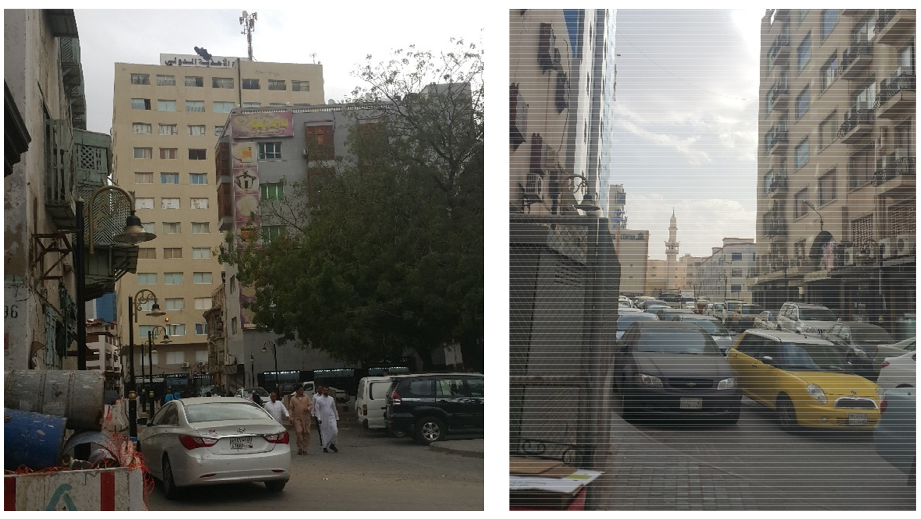
Moreover, literature on the current conditions of historic Arab centers reveals certain physical phenomena. Large buildings are taking over the city scene bringing more traffic [8,16]. More traffic has led to a more congested traffic network, as shown in Figure 3, creating wider spaces increasing thermal loads on buildings, and extra thermal loads pushed for a higher air-conditioning dependency. More air conditioning left the outdoor spaces subject to larger thermal loads [1,22].
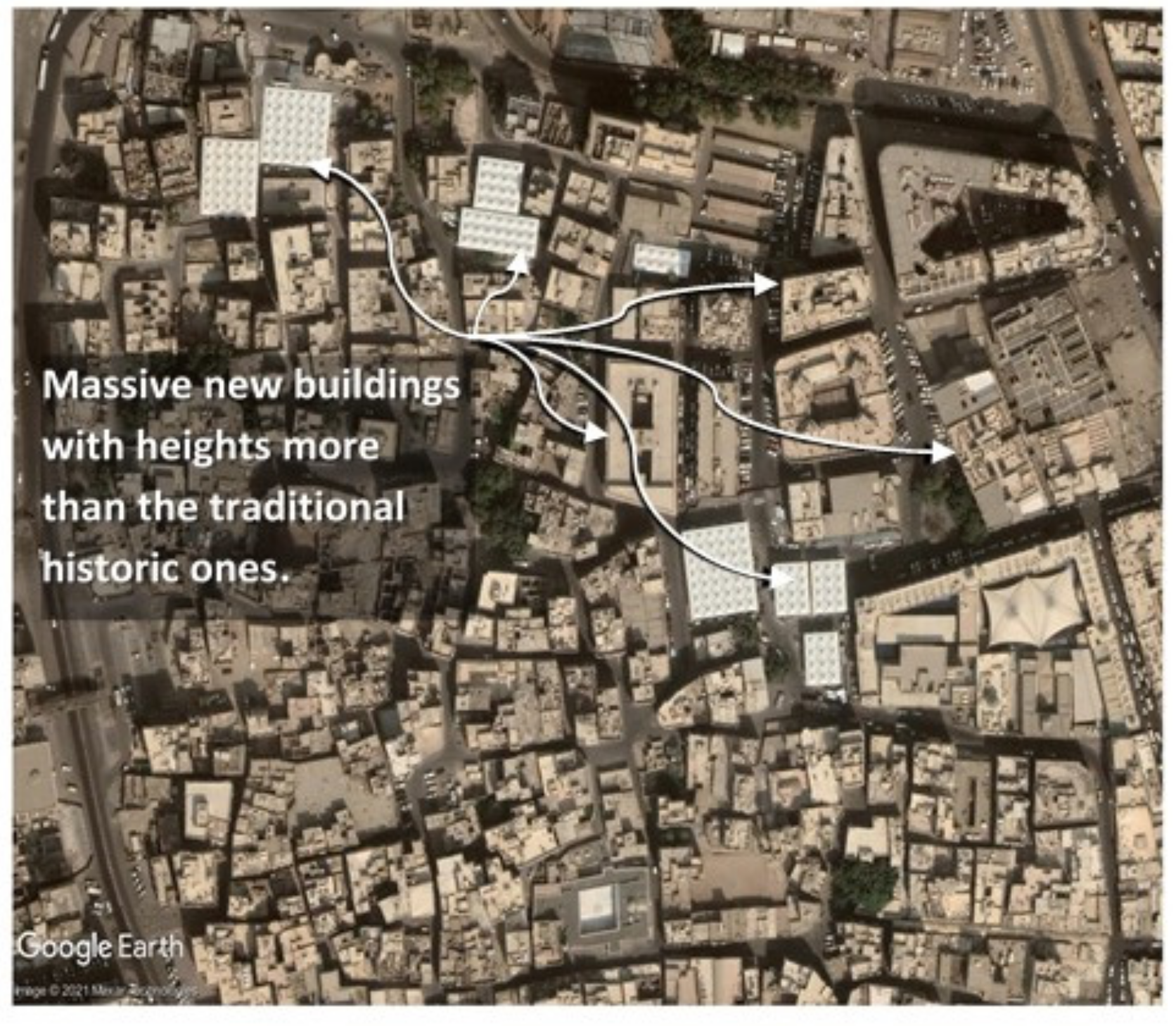
Socioeconomically, as part of the vertical immigration within the cities, original residents deserted their historic low service areas and were replaced with residents from different classes with different cultural values and habits [23]. The informal economy flourished and impacted local business owners poorly [24]. Environmentally, the internally oriented built environment used passive cooling strategies, today transformed into outward-looking massive buildings with unprotected open spaces heavily dependent on mechanical air-conditioning systems. Figure 4 illustrates the historic area where new massive buildings replaced the historical ones [10]. Un-serviced areas with deteriorated built environments began to be deserted by their residents.
3. Theoretical Background and Contextual Approach
3.1. Evolution of Heritage Definition
Bruno Favel [25] cited three different changes for the heritage definition: The first defined it as a monument embodying the nation’s values. Later, the definition expanded to include private monuments, monuments in their environmental context, neighborhoods, and everyday immaterial heritage. Since then, the heritage definition has expanded to include all aspects of culture, such as language, food, and arts [26]. Since then, conservation authorities worldwide have begun to consider protecting the intangible components of urban heritage in their conservation and restoration projects [25].
3.2. Historic Urban Landscape Approach (HUL)
In 2005, the fifth general assembly of state parties to the convention concerning the protection of the world’s cultural and natural heritage expanded the heritage definition to include the historic urban landscape; the definition was widened to include a profound understanding of the living and inhabited landscape. The historic urban landscape is embedded in the current and past of the place-based social expressions and composed of character-defining elements including spatial organization, land uses, visual relationships, natural elements such as topography, soils, and vegetation, in addition to all technical infrastructure elements, including construction details [27]. As the concept of heritage evolved, intangible heritage and culture have been recognized as heritage [28].
The Historic Urban Landscape (HUL) is defined as the “historical layering of cultural and natural values and attributes” (Article 8), integrating the intangible aspects of heritage and its related processes. This approach distinguishes the need to protect, conserve, and valorize cultural and natural heritage in a rapid and uncontrolled urbanized world. Moreover, this approach integrates heritage conservation plans into the development strategies [27].
3.3. Urban Heritage
In 1987, historic urban areas were defined in the ICOMOS Washington Charter as either large or small, including cities, towns, and historical centers. Their natural and built environments embody the values of traditional urban cultures [29].
Urban heritage reflects the local community’s identity, memories, and authenticity. It has been the source of civic pride and should be the driving force behind any restoration efforts [30]. Prosperous urban areas attract visitors to participate in cultural activities within their open public spaces [31]. There is a growing shift in heritage research trends toward a dynamic process [24]. Through this process, urban heritage should first be defined for its cultural value to a group of people; then, effort should be made to conserve it and pass it on to future generations [25]. Hall proposed this process as a “cultural circuit” that explains how heritage is constructed through cultural production, representation, and consumption. Smith also emphasizes urban heritage as a cultural process of remembering the work, creating ways to understand it, and engaging it with the present. He also argues that the tangible elements are the cultural tools for facilitating this process. Moreover, he claimed that the potential social value of heritage was first recognized in 2005, the Australia ICOMOS Article 1.2, when the previously used terms “monument” and “site” were replaced by the broad term of “place” as a heritage subject for conservation. In the URBAN II urban regeneration funding program, deteriorated urban areas were defined as areas with deteriorated economy and high unemployment, crime, school dropout rates, and a deteriorated physical and social environment [32].
Later, as of 2011, in the Recommendation on the Historic Urban Landscape Report of the Second Consultation on its implementation by the Member States, urban heritage was categorized into three main types. Firstly, a monumental heritage of outstanding cultural value; secondly, non-exceptional heritage elements that are present in a coherent way with a relative plenitude; thirdly, the new urban elements such as the urban built form, streets, or regular/public open spaces; and lastly, urban infrastructures such as material networks and equipment [33].
In 2019, cultural heritage was defined in the first article of UNESCO’s Operational Guidelines of the World Heritage Convention as separate or connected buildings. This heritage includes archaeological sites characterized as ethnological, archaeological, historical, or aesthetic [30]. The unique universal value of these monuments comes from their architecture, homogeneity, or place in the landscape, and this value is evaluated in light of history, art, or science [30]. Moreover, article 47, in the same document, defined the cultural landscape as manmade, either integrated within natural sites or not. Moreover, the third annex of the guidelines listed five categories as heritage: Cultural landscape, historic towns and downtowns, heritage canals, and heritage routes [34].
3.4. Urban Heritage Conservation (UHC)
The Burra Charter identified the need to involve people in different phases, particularly those with solid cultural significance. In the 1999 Australia ICOMOS charter, value-based management was divided into three phases: Significance assessment, policy development, and management [35]. Further revisions of these charters included a fourth phase for assessing vulnerability and identifying threats to cultural significance [36]. As cited by K. Ashour, Roberts’ successful regeneration was defined as conserving the physical urban fabric, creating an economic base, supporting social structures, and improving environmental conditions, following sustainability principles. It must have a strategic vision, clear, measurable objectives, and tools to measure them, utilize resources efficiently, and involve all stakeholders [37].
As stated in the report of member states’ national survey, conducted by the UNESCO World Heritage Centre and titled “the second consultation on implementing the historic urban landscape approach by member states” dated in 2019, none of the Arab members adopted the concept to make use of the Heritage Urban Landscape approach [33]. Heritage conservation efforts within Arab cities have been focused on physical and materialized forms.
4. Methodology and Assessment Framework
A few researchers discuss the assessment of conservation activities. Efficiency and effectiveness measures are the basis of any acceptable assessment framework, and an empirical assessment provides information on issues of the measurement of conservation outputs. Moreover, it highlights the usefulness of adopting specific indicators assessing the conservation decision-making process [28]. This assessment process is straightforward in cases of physical heritage conservation. Ilde Rizzo, as cited by Pietro, highlighted the following arguable assessment issues: Scope, priorities, intervention strategies, conservation strategies, and long-term outcomes [38]. The currently adopted definition of heritage comprises the physical urban environment and intangible cultural values. In such cases, conservation activities must be embedded within the urban development plans, and residents’ participation in different phases of conservation is required [39].
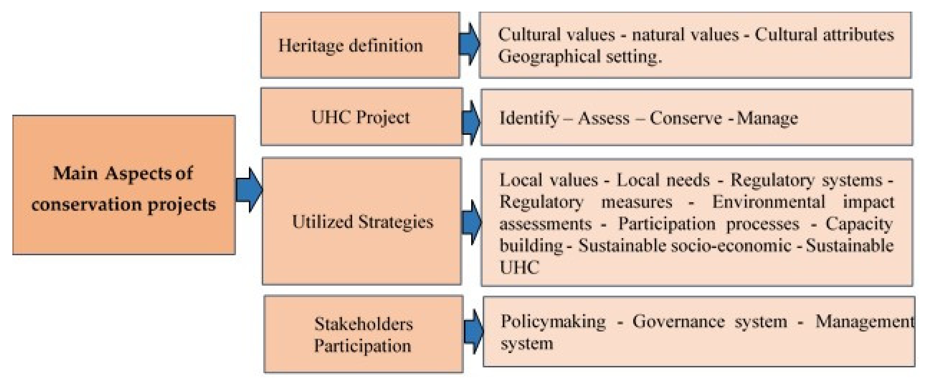
L. Veldpaus et al. extracted the main phases of urban heritage conservation out of 28 international policy documents. She concluded that the conservation evaluation framework needs to be based on the four main pillars of conservation projects. First, the heritage definition must be broadened to be inclusive of the built environment and the geographical setting. Second, the main objective of the conservation project must depend on a comprehensive, integrated approach in identifying, assessing, conserving, and managing the urban heritage significance. Third, strategies must be utilized for engaging localized national authorities to develop tools and instruments to respond positively to local values and needs. Such values and needs can be associated with governing systems, the participatory approach, environmental impact assessment, and sustainable socio-economic urban heritage development. Fourth, various local, national, and international stakeholders must be positively engaged in policymaking, governance system, and management of the conservation efforts of the urban heritage area [40,41]. Successful UHL should be built on involving communities, decision-makers, planners, and managers [36]. Figure 5 summarizes the main sustainable urban heritage conservation aspects.
Samrqandi, in her urban quality evaluation workflow, defined six attributes for the evaluation of heritage places: Access and linkage, comfort and image, uses and activities, sociability, context and conservation, and site interpretation [42]. Abou-Soliman suggested five physical features for vibrant urban heritage: Accessibility, having a suitable scale and form for located activities, accommodating appropriate usage, encouraging visitors’ activities, and infrastructure and services to support designated activities. He also suggested seven intangible qualities for successful public space features for thriving urban heritage: Vibrant, readable, defined, meaningful, safe, symbolic, and encouraging [43]. The concept of intangible attributes ranges from asset-related features such as character, style, and uses to ‘people’ and processes. As international interest in community sustainability increased over two decades, practices, traditions, people, and communities were added as independent attributes [41].
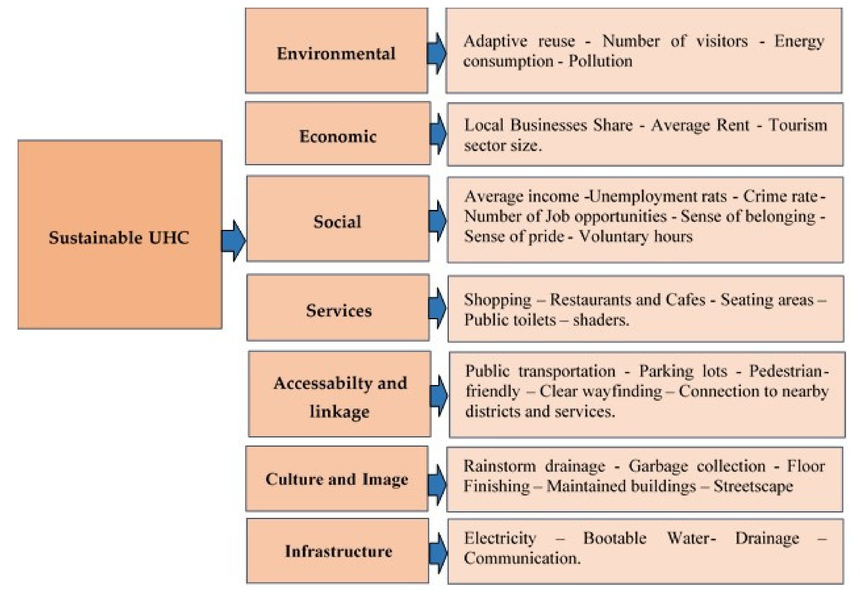
Indicators are required to evaluate the success of any culture or heritage conservation-related programs. They must be conceptually based and simplified to be practical. Traditionally, experts and professionals make the indicators’ selection [28]. Researchers in conservation, economics, sociology, and environmental fields have proposed different indicators to assess their areas of study activities, with the leading indicators used for each of these intersected fields of heritage conservation assessment [1]. Figure 6 presents the main attributes for urban quality assessment and indicators of successful sustainable UHC as extracted from the literature review [1,43].
A proposed framework that relates the UHC aspects and the resulting qualities of the targeted urban area is presented in Table 1 where:
- As concluded from the theoretical background, five aspects of the UHC project have to be accomplished through twenty practices. Each one of these development practices has an impact on the success of the resulting urban heritage. These practices comprise the table header.
- Urban quality attributes, representing the development success, fell into seven main areas and can be estimated through thirty-three indicators. These quality indicators constitute the table rows.
- The proposed relation between practices and quality indicators is categorized into five different shades; the darker color represents a strong impact and has a weight of five, while the lighter shade represents a lower impact and has the value of one.
Some of these indicators are objective and can be calculated or measured statistically, such as the unemployment rate and created job opportunities. Others will be represented with no or yes, such as public transportation and car parking areas; others are subjective, and their value will depend on the degree of practice, such as the sense of pride and sense of belonging and need to be collected through a public survey.
5. Case Studies
Two historic sample centers were selected to investigate the impact of the management policies on the urban condition of these fragile built environments. As mentioned before, most Arab countries did not take advantage of HUL. Despite the subsequent case studies not considering this approach in their conservation efforts, they have some similar aspects. For example, Amman conservation efforts integrated conservation into the city strategic plan, and there is a clear vision for touristic attraction and creating job opportunities. Meanwhile, in Jeddah, a dedicated management administration is taking care of the conservation efforts.
Jeddah’s historic center was chosen to represent cities within the wealthy Arab countries, and historic Jeddah received much attention from both the national and international heritage authorities. Despite the availability of generous governmental funds, the historic center suffers as much social and environmental deterioration as the rest of the region’s historical centers [1,45]. The second case study was the Amman Historic center, which lacked funds and depended mainly on international aid for conservation activities. As mentioned by Smith, international aid usually comes with predefined priorities and scope of conservation [46]. Conservation efforts and urban management plans aimed for socio-economic uplifting to mitigate the requirements of the booming number of refugees within the city [19,45,46].
5.1. Amman City
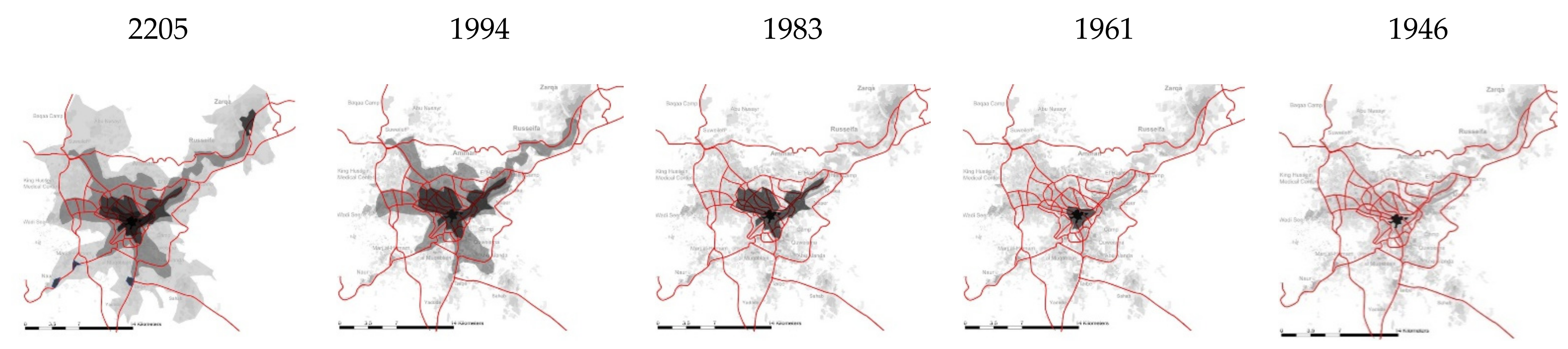
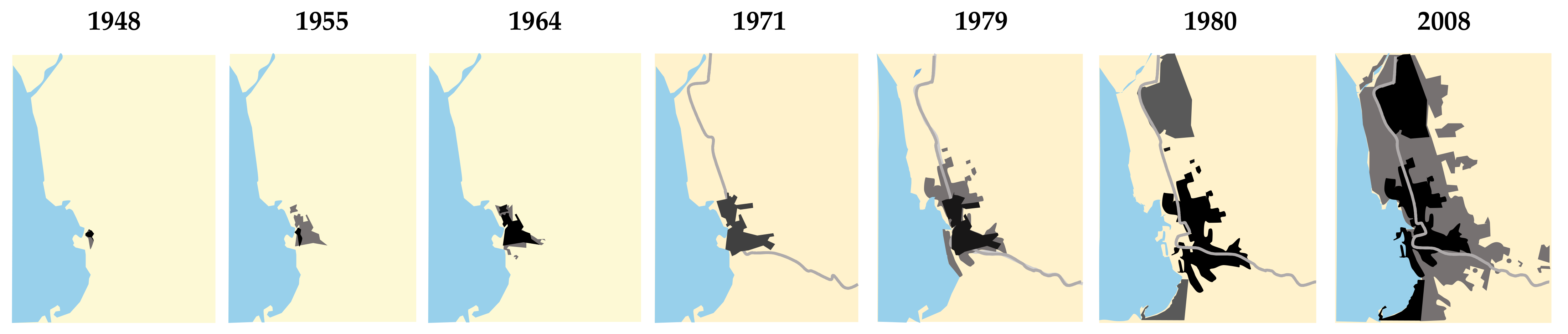
Despite Amman City’s historical background, its first existence as the city we know today started in the early twenties of the last century, the Ottoman era, as an intermediate Junction on the Hijaz railway line. Amman’s population at that time was about 5000 inhabitants, in an urban area of 0.321 km2. Amman has been the fastest growing city globally in the past few decades due to several immigration waves from neighboring countries [19,21]. In 2020, Amman had an urban area of around 0.321 km2 with less than 5 million inhabitants in the latest available statistics. Figure 7 illustrates a tempo map for the urban city growth [46,47].
5.1.1. Amman Historical Center “Albalad”
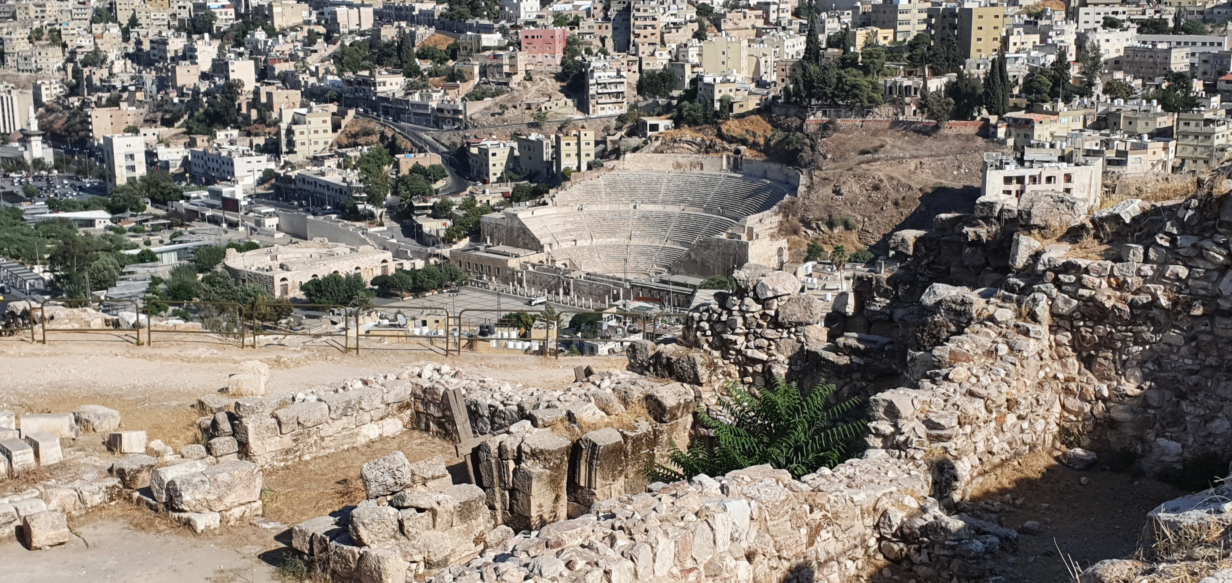
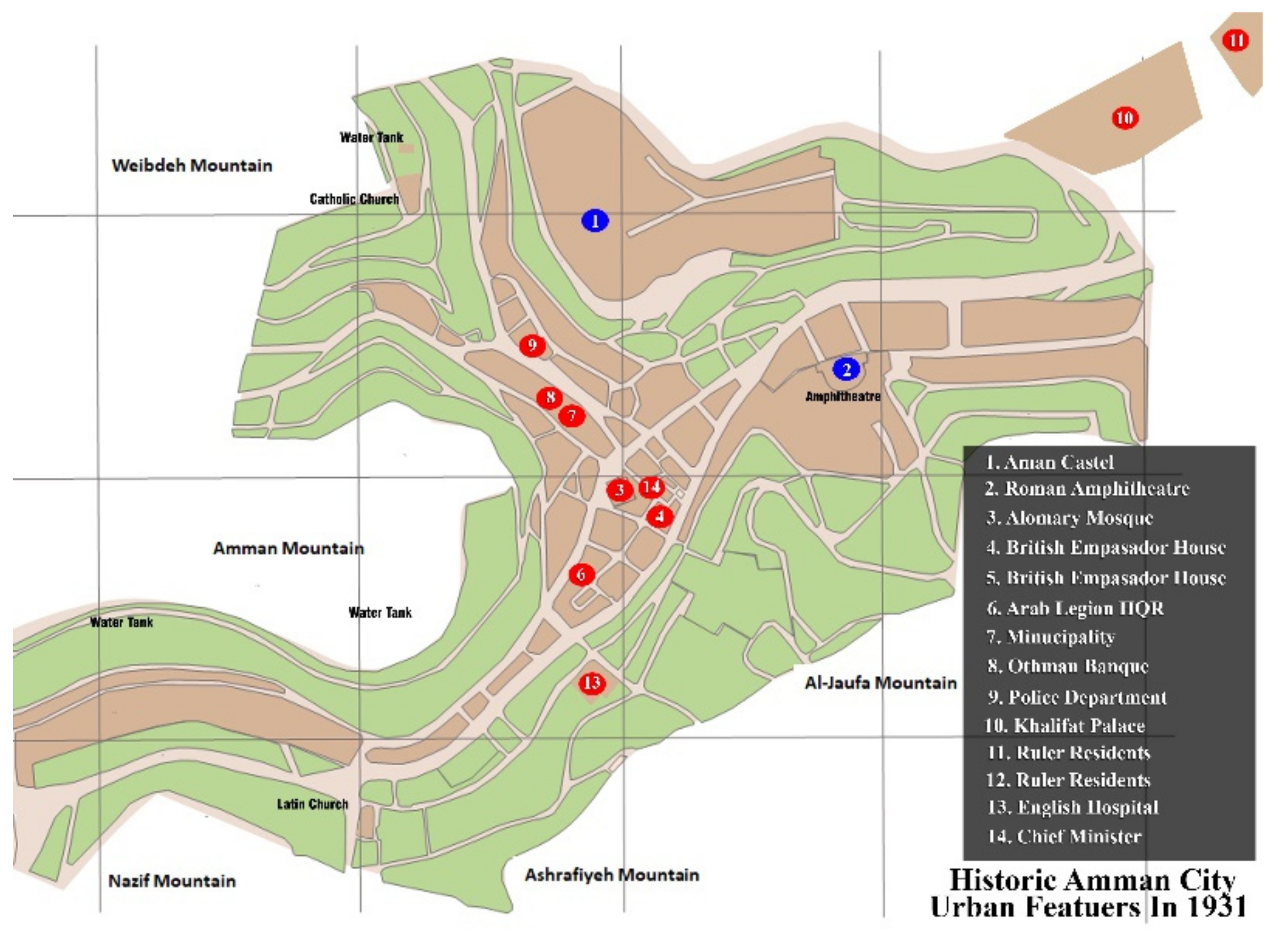
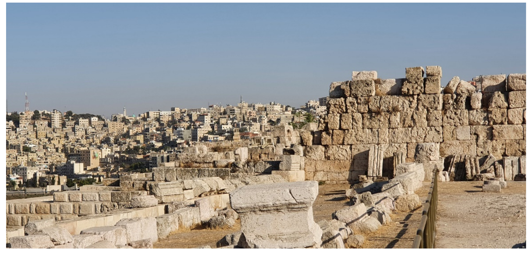
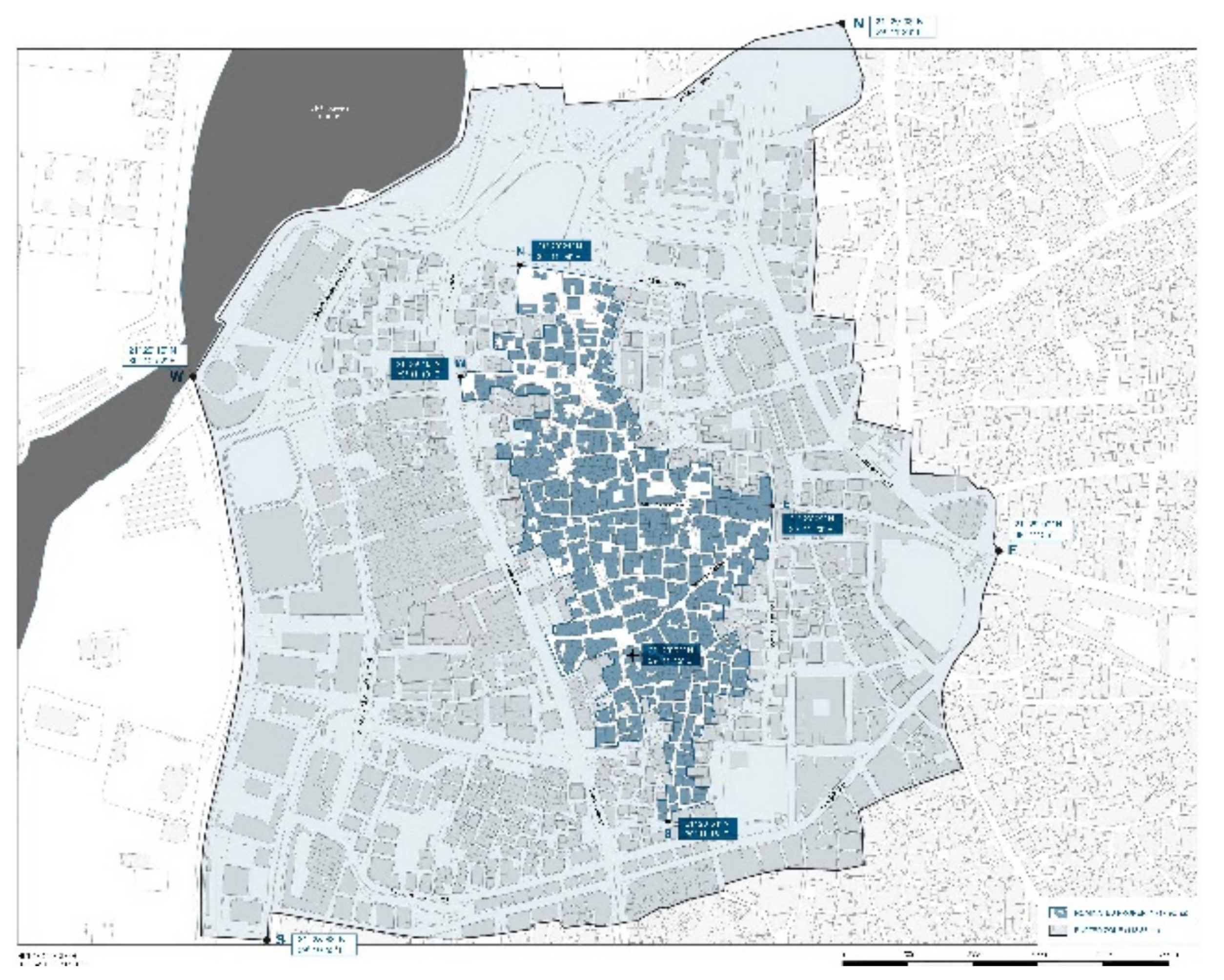
As shown in Figure 8, the historic Amman or “Albalad” used to be the central market, administrative center, and transportation hub, surrounded by residential areas on the neighboring hills. The hills’ topography and valley shape influenced the pattern of the physical development of the 182 hectares of the historic city. The urban pattern adopted the natural physical form. The city expanded following the contours up to the surrounding hilltops. The neighborhoods were connected via stepped alleys as pedestrian links to the city center [19,36]. In addition to its traditional urban, wholesale market, and leisure facilities, the “Albalad” area is near archeological sites with monuments from different eras, such as the mountain castle, the citadel, the Hercules temple, the Roman theater, the Umayyad palace, and the Alhosainy Grand Mosque [19,30].
5.1.2. Conservation Activities
Amman City was subject to several development plans. In 1955, a development plan was approved by the Greater Amman Municipality (GAM) to mitigate the growing demand for housing, services, and the lack of job opportunities [19,47]. Later, in 1968, another master plan was suggested to manage the fast-growing informal settlements, lack of services, road congestion, centralization of business and commercial activities, and high unemployment rates. In 1978, a Japanese firm (IECA) proposed relieving the growing traffic congestion and increasing municipal revenues. GAM proposed and approved the city’s final master plan from 2008 to 2025. This master plan was a comprehensive, multilevel sustainable plan [48].
Moreover, this plan came as a participatory effort of all stakeholders. The master plan framework defines urban policies, strategies, land use, legislation, and public participation [21]. The main objective for the historic central conservation was to improve its local economy and social cohesion, recover its centrality within the city, and revive its authenticity and social cohesion. The tools to achieve these objectives were creating spaces for everyone and preserving the cultural heritage with symbolic values. Creating a high-quality environmental and social urban fabric would create a tourist commodity. Increasing tourism activities would create a prosperous community [19]. Participatory community activities helped attract private investment and created an environment for businesses and community involvement projects [19]. The action plan’s proposed projects shown in Figure 9 were adopted to achieve the objectives for the Albalad area.
5.1.3. Current Urban Management Plans
The current master plan includes the following multidirectional urban management programs:
- Re-establish the Albalad as a commercial destination by conserving the existing traditional market’s character. Regulate the informal street retailers to achieve a vibrant street mall with good urban design qualities and enhance the specialized and thematic commercial areas.
- Define cultural heritage buildings and districts. Conserve and adapt the reuse of heritage buildings. Implement guidelines for heritage protection and encourage artistic and cultural activities.
- Establish connections between the public realm and its surrounding areas through pedestrian and public transport routes and public and commercial spaces. Improve the image quality of public space and create gateways and thematic landmarks.
- Preserve the existing urban physical character in form and visual relationship with surrounding hilltops.
- Support tourism by enhancing the heritage district spirit, defining the tourist pedestrian routes, and providing tourist services and cultural activities.
- Create an entertaining district by establishing a mixed-use character of specialty retail, cafes, and restaurants. At the same time, make arrangements to hold entertainment venues, festivals, and cultural events.
5.1.4. Impact of Implemented Development Actions
Amman’s downtown development plan is still in progress. Urban management in terms of enforcing regulations and legalizations successfully revitalized the area as a traditional commercial center. It has created cultural and public spaces facilitating cultural and artistic events. The adopted public uses for the first floor of buildings on selected historical paths for cafes and restaurants created unique and vibrant public spaces. Traffic arrangements and transportation plans helped in easing congestion within the area. Table 2 presents a subjective assessment of the urban quality of the conserved historical center.

Table 2.
Quality assessment of the “Albalad” conserved urban area (Amman City).
| Area | Assessment |
|---|---|
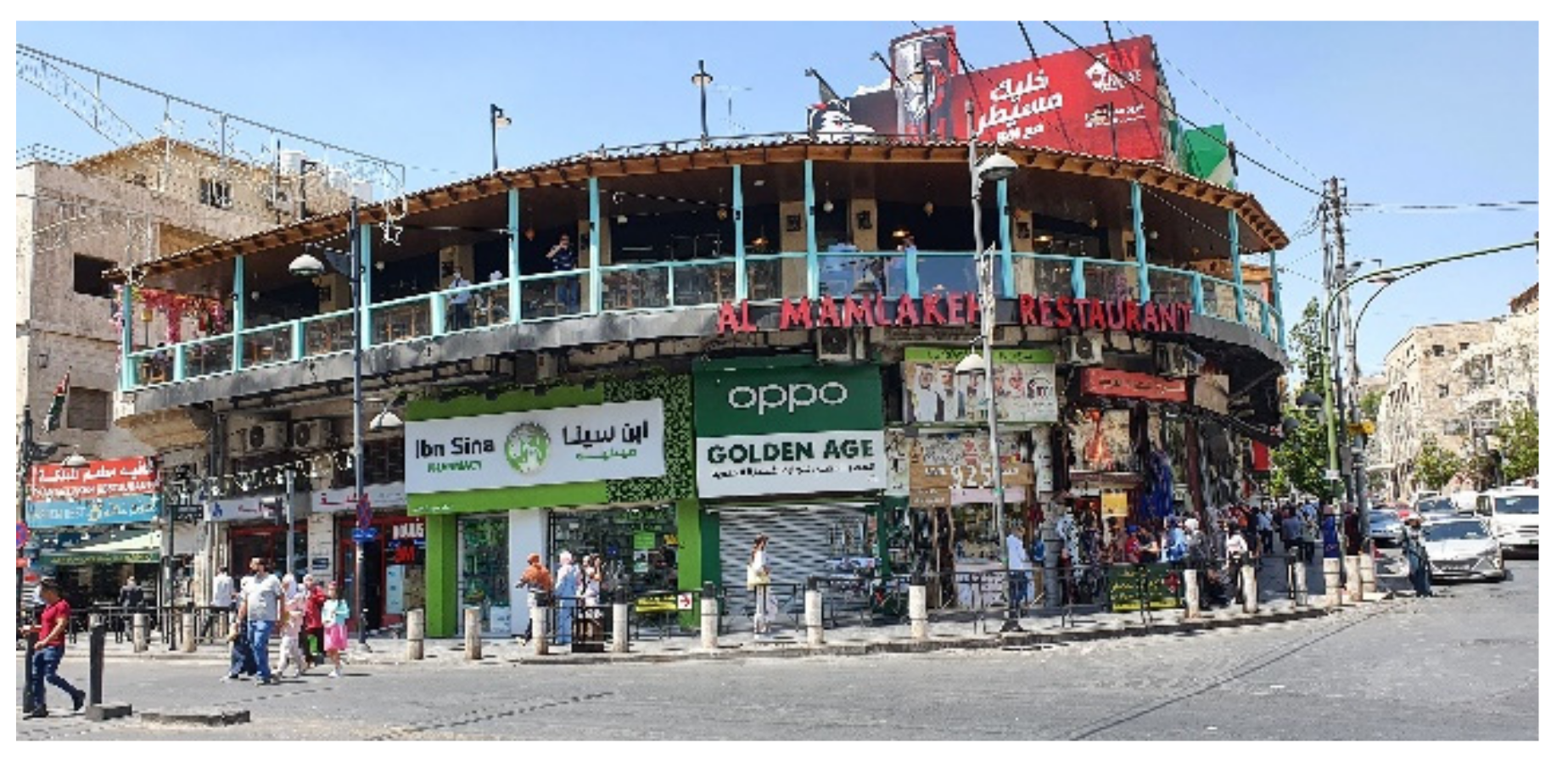
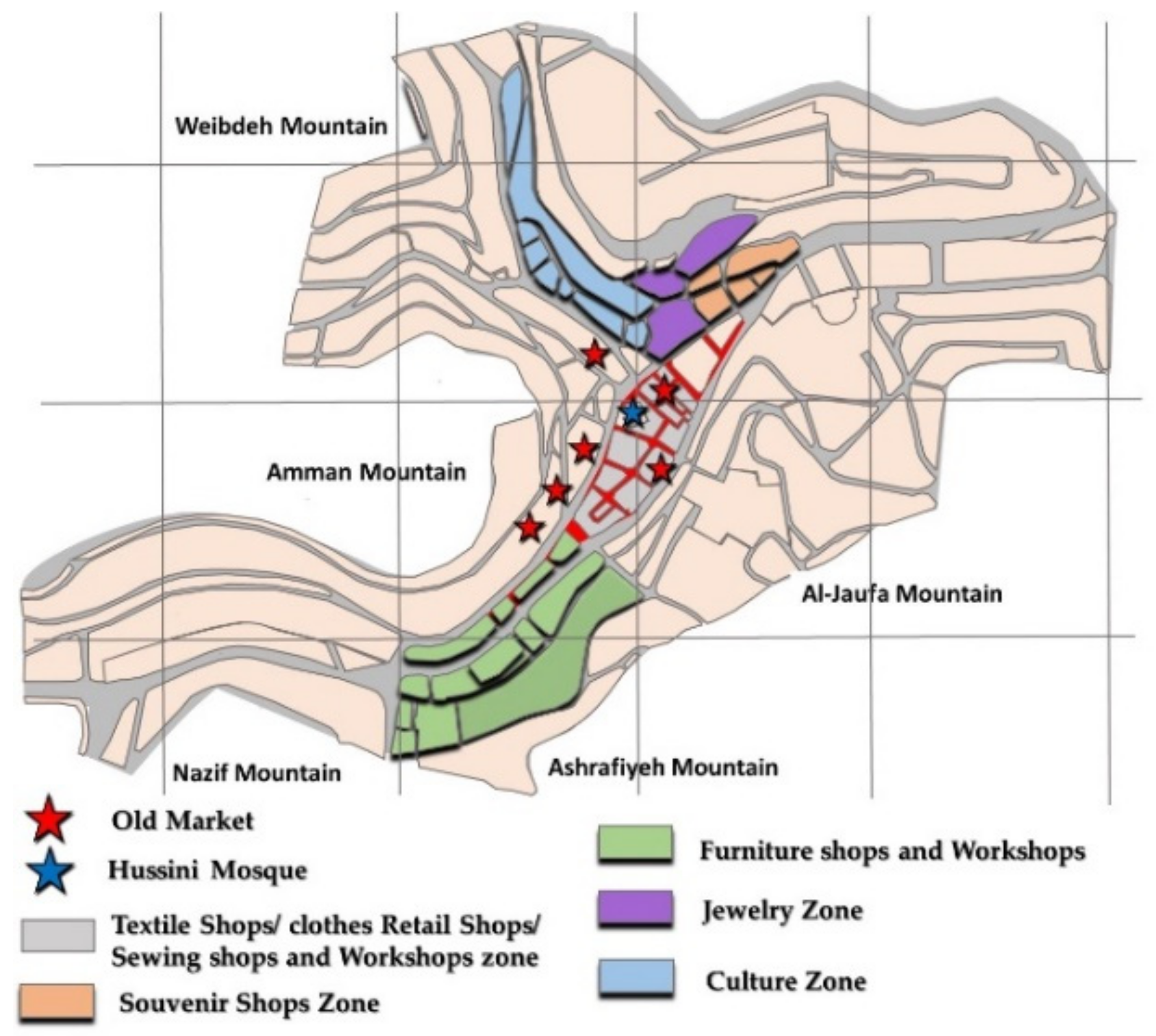
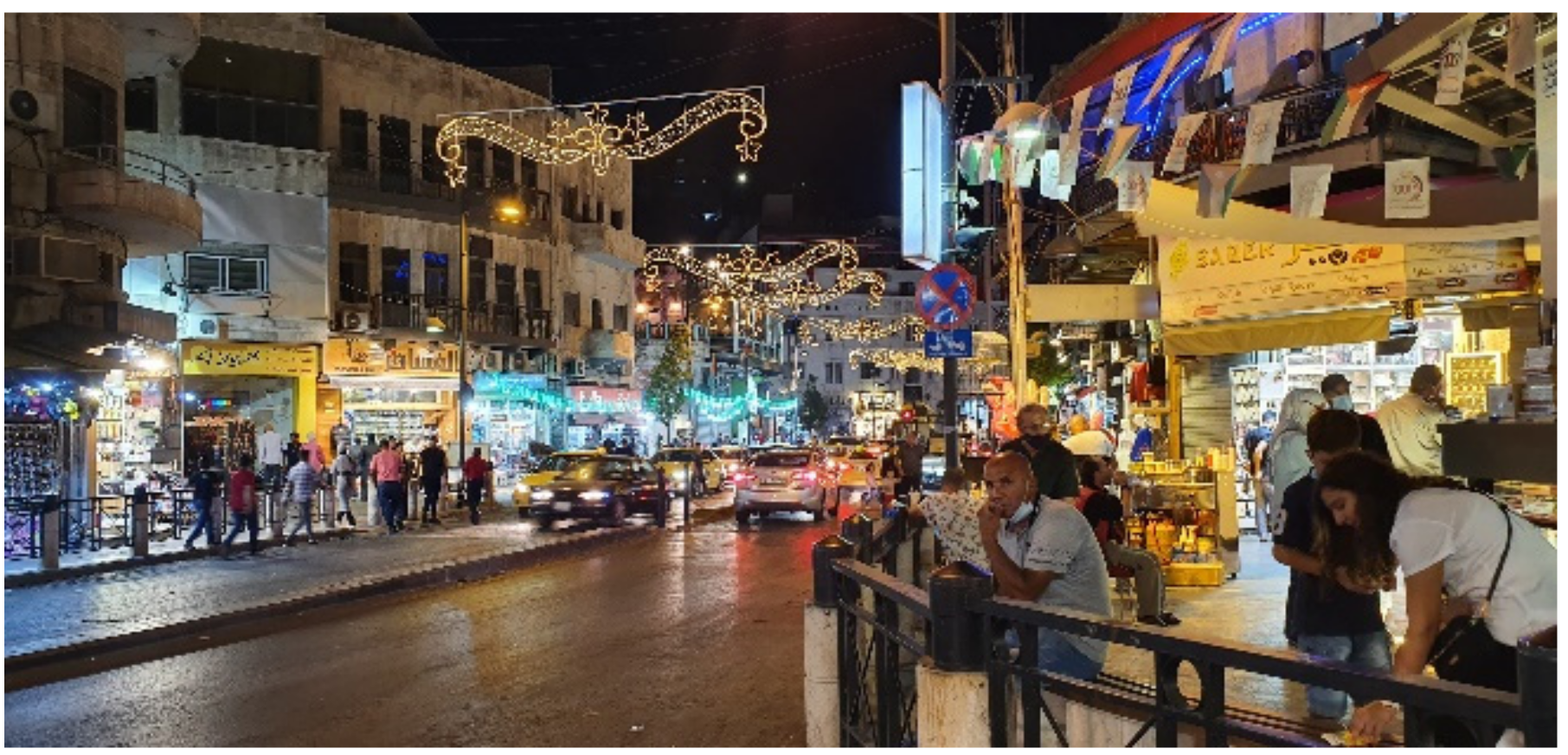
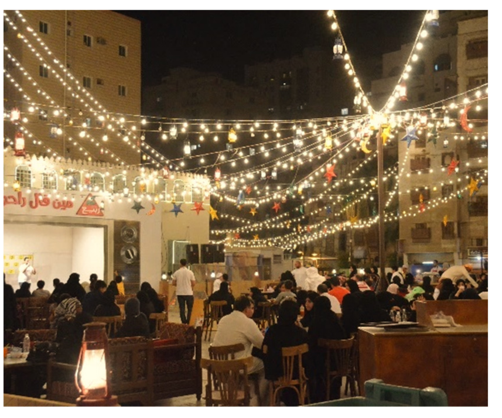
| Environment | Adaptive reuse: Commercial ground floors spread evenly through the narrow allays as using first floors as cafes and restaurants attracted more visitors shown in Figure 10 Traditional food and specialized cafes and restaurants and gift shops and bazaars are the majority of the ground floor uses, as shown in the map in Figure 11. At the same time, some famous restaurants are situated on the first floor, as shown in Figure 10. The number of visitors: As the COVID-19 pandemic impacts started to decrease, the area flourished with visitors from other cities and regions. The statistics revealed a 30% increase in tourists’ numbers between 2016 and 2019 [49]. Photos in Figure 12 show the vibrant spaces of the city. Energy consumption: Despite that the area climate is considered moderate, adding decorative lights throughout the streets is shown in Figure 12 and Figure 13. Extending the working hours for the commercial area increases the electricity consumption. Pollution: Adding a ring road and two central stations and arranging an internal taxi shuttle service helped ease traffic congestion within the area and reduce air pollution. Preserving the ever-green trees improved the visual and environmental qualities of the area. |
| Economic | Local Businesses Share: Statistics are not available at this stage. Average Rent: Hotel rooms’ rent varies at 150–250 JD. Exact statistics are not available at this stage. Tourism sector size: Statistics are not available at this stage. |
| Social | Average income: Lower-middle-class income is 4850 JD average income while poverty line is above 3737 JD statistics within the area ranges is not available at this stage. [50] Unemployment rates: Department of Jordanian statistics show that the unemployment rate in Amman in 2021 in the second quarter was 24.8% [49] Crime rate: Not available at this stage.The number of job opportunities: One of the objectives of the area development was to create jobs. [48]. The ongoing development of the Albalad allowed Hawkers to use the sidewalks to create more jobs, as shown in Figure 14. Sense of belonging: Many residents do not originate in the city and have no sense of belonging; they still enjoy the center and benefit economically, as shown in Figure 15. Sense of pride: Native residents are not happy with the rising refugee numbers because they share their services and the limited job opportunities. Volunteer hours: Statistics are not available at this stage. |
| Services | Shopping: Traditional food, touristic gift shops, cultural events, and cleanly maintained walkways give the public spaces a vibrant image, as illustrated in Figure 13, Figure 14, Figure 15 and Figure 16. Restaurants and Cafes: As per the land use map in Figure 11 Seating areas: Publish seating areas are limited, but outdoor cafes are distributed on the main streets and the stepped alleys. Public toilets: No public toilets except the Mosques and restaurants. Shaders: All the alleys have shaders with different designs and formations. Figure 17 illustrates some of these shading units. |
| Accessibility and Linkage | Public transportation: The area has a taxi shuttle service and two main public transportation stations to link the area to the city districts. Parking lots: There is parking on the streets and parking lots near the two newly refurbished stations. Pedestrian-friendly: The walkways are separated from the cars Clear wayfinding: Streets’ slopes and surrounding hills make clear landmarks for visitors. These slops make it easy to move around. Connection to nearby districts and services: The neighboring areas are mainly on the surrounding slopes, meaning the linkage is not direct or easy. |
| Culture and image | Rainstorm drainage: The area is a valley surrounded by hills. Several projects to make the best use of the floodwater. Garbage collection: The area is serviced by an effective garbage collection system. Floor Finishing: Walkways using finishing are not expensive, but their details are well designed and constructed. Maintained buildings: Archeological sites lack services, and their surroundings are not well-maintained, as shown in Figure 10, which exhibits the physical conditions of the nearby Castel mountain archeological site. Preserving the contours helped to maintain the original character of the Albalad area Figure 18. Moreover, limiting the building heights to three or four floors maintained the visual contact with the surrounding hilltops and the ratios of the width of the spaces to their surrounding buildings, as presented in Figure 13. Preserving the ever-green trees improved the visual and environmental qualities of the spaces. Streetscape: Walking around gives a rich visual experience either day or night, despite some visual pollution resulting from the suspended electric cables and shops signs with different colors and sizes. |
| Infrastructure | Electricity: The area is covered by electricity. Electric cables are suspended along the many streets within the area. Bootable Water: The area is served by a water network despite the issue of hell areas. Drainage: The area is covered by a sewerage network despite the issue of hell areas. Communication: There is well covered by phone and internet service. |
5.2. Jeddah City
With more or less 5 million inhabitants, Jeddah ranks second in size as a Saudi city after Riyadh. It is the economic capital and the main port of the Kingdom of Saudi Arabia. Additionally, it is part of the Red Sea civilization. Jeddah is one of the oldest cities in the region, and it was inhabited about one thousand years before the Crist and has been a trading hub for the region since then [51]. Most of the urban fabric, city walls, the six gates, and residential and public buildings belong to the Ottoman era of the 15th century. Jeddah’s modernization started with the Saudi Kingdom. In this area, the city has witnessed several changes.
Historic city walls and gates were demolished in 1948: The city expanded to the north, a new port was established to the south, and an airport was constructed. Later in the 1970s, shopping malls and office buildings were built in the demolished western part of the historic city. A new road network and parking facilities were built to meet the newly growing demand of its inhabitants [51,52,53]. Figure 19 illustrates the city’s growth over the six decades. Due to these modernization activities, the historic district of Jeddah that was once an entire walled city had become a tiny area within the city itself. The historical Jeddah lost whole sections of its original urban fabric. The new modern buildings were concentrated next to the seashore [1,51,53]. During the 1980s and 1990s, the area was no longer able to provide the requirements of contemporary life for its original residents, and they abandoned the area and moved gradually to the wealthy, newly developed areas to the north. Over time, the area started to decline in its economic and social characteristics and converted into an entirely rented area for poor foreign immigrants [52,53].
5.2.1. Jeddah Historical Center
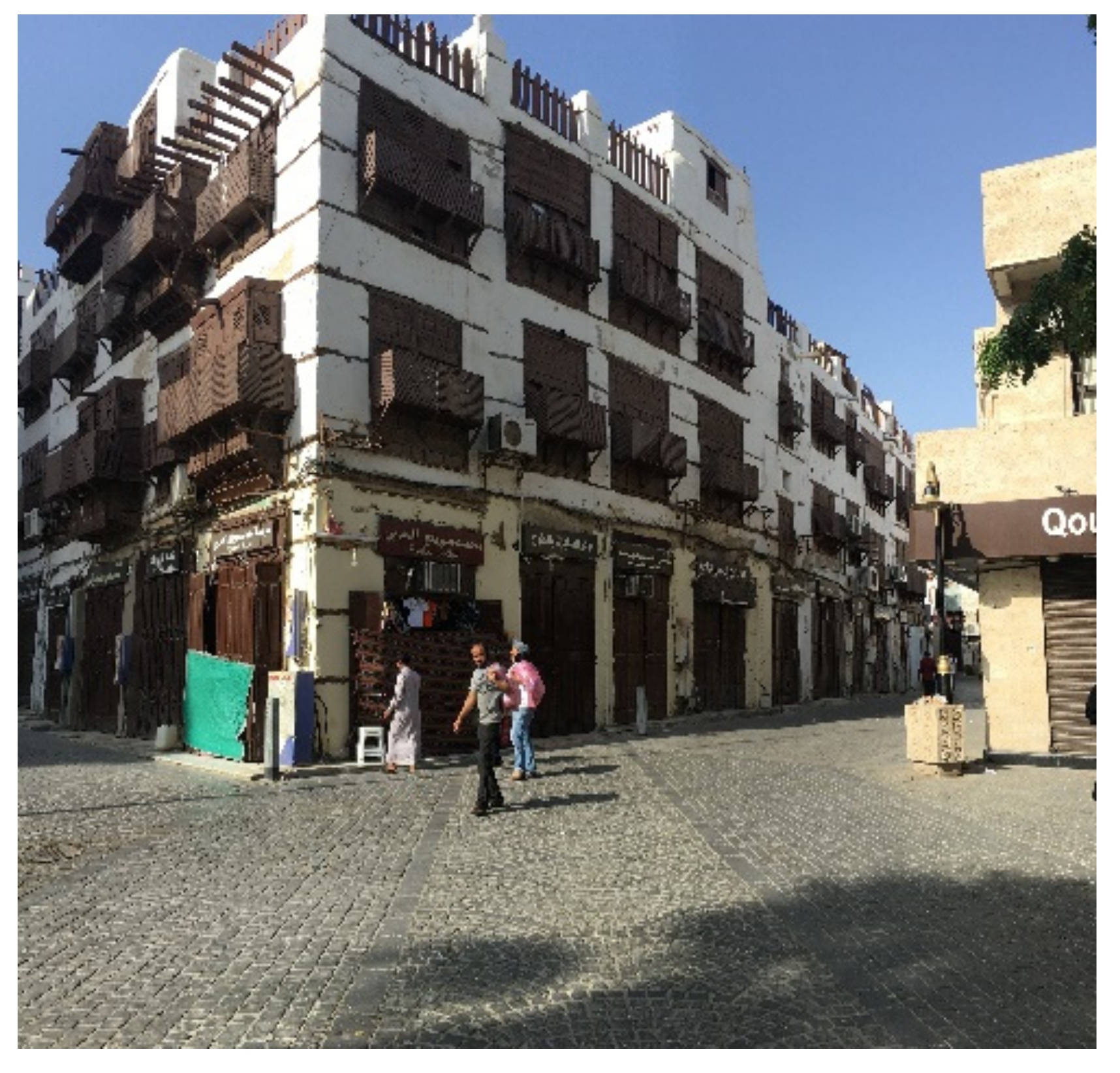
Historic Jeddah, known as Albalad, extends over seventeen hectares, and it symbolizes the heritage and culture of the city. The cityscape of historic Jeddah resulted from an exchange of local culture, environmental conditions, technical construction systems, and materials [54]. Its architectural style is characterized by three- to four-story coral stone residences, decorated with openings covered with wooden “Roshan” [55]. Figure 20 shows the location and spatial organization of these houses. The area’s outstanding universal value is based on its unique architectural style and urban character [54,56].
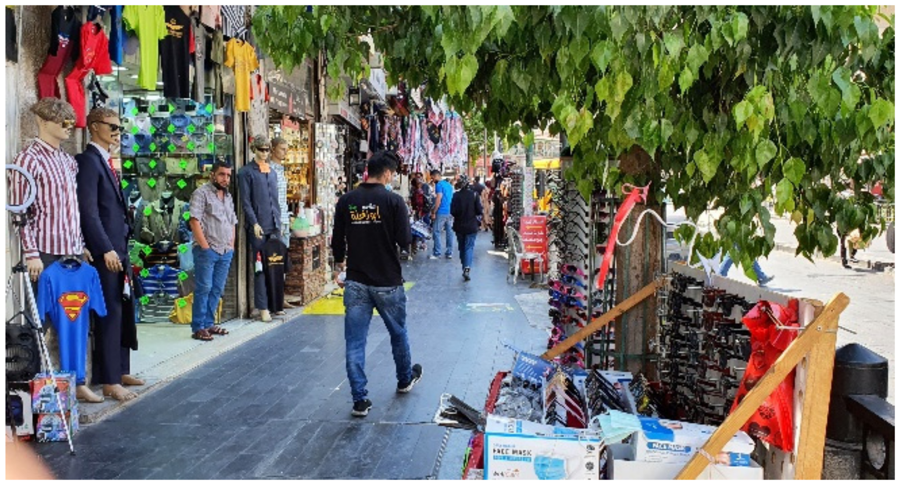
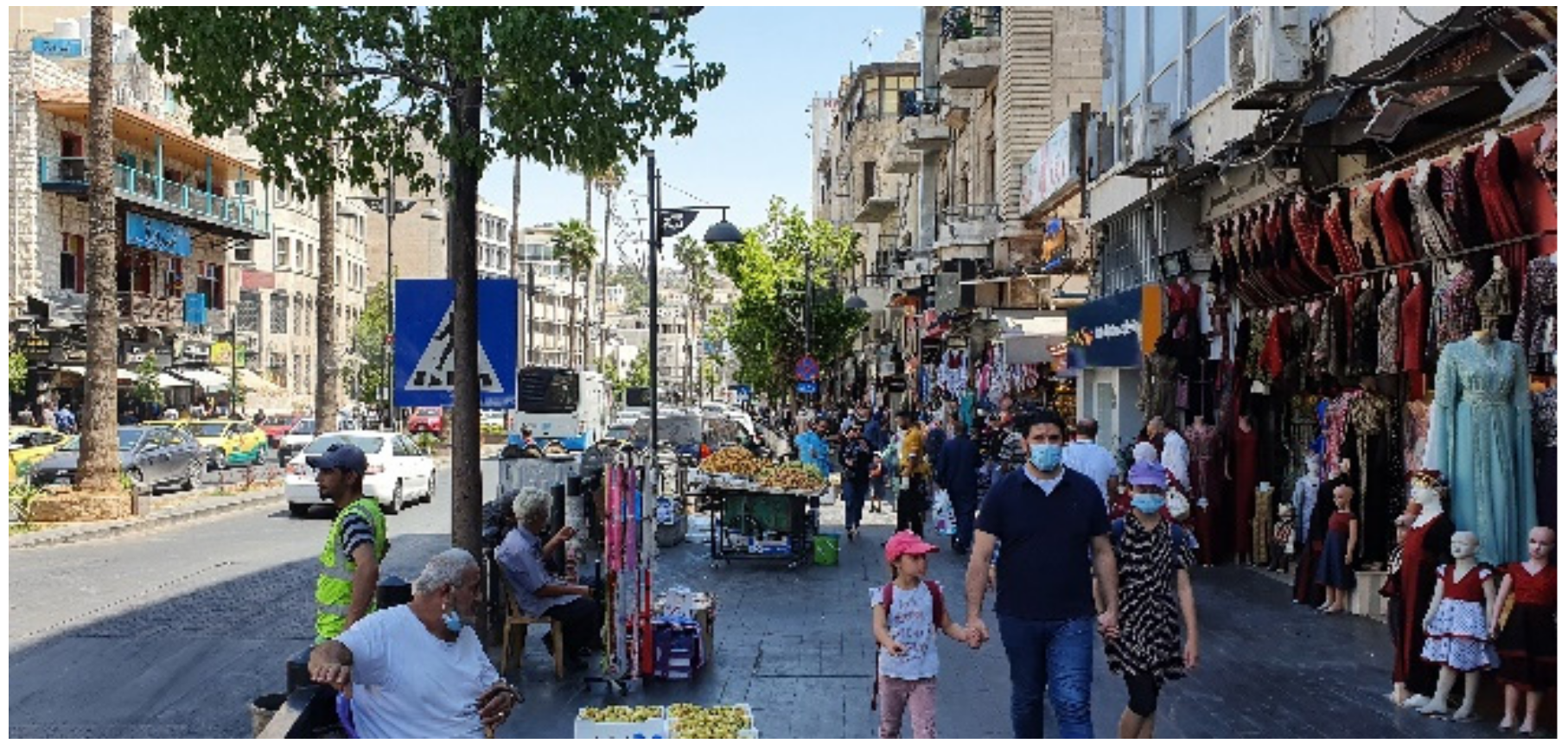
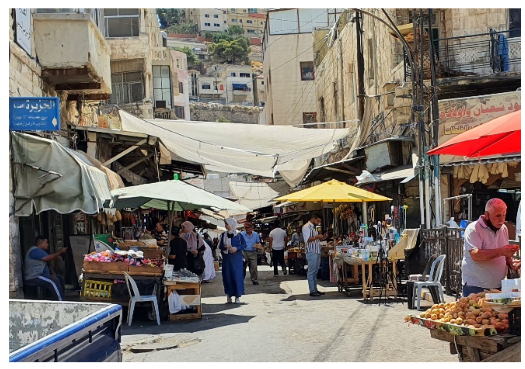
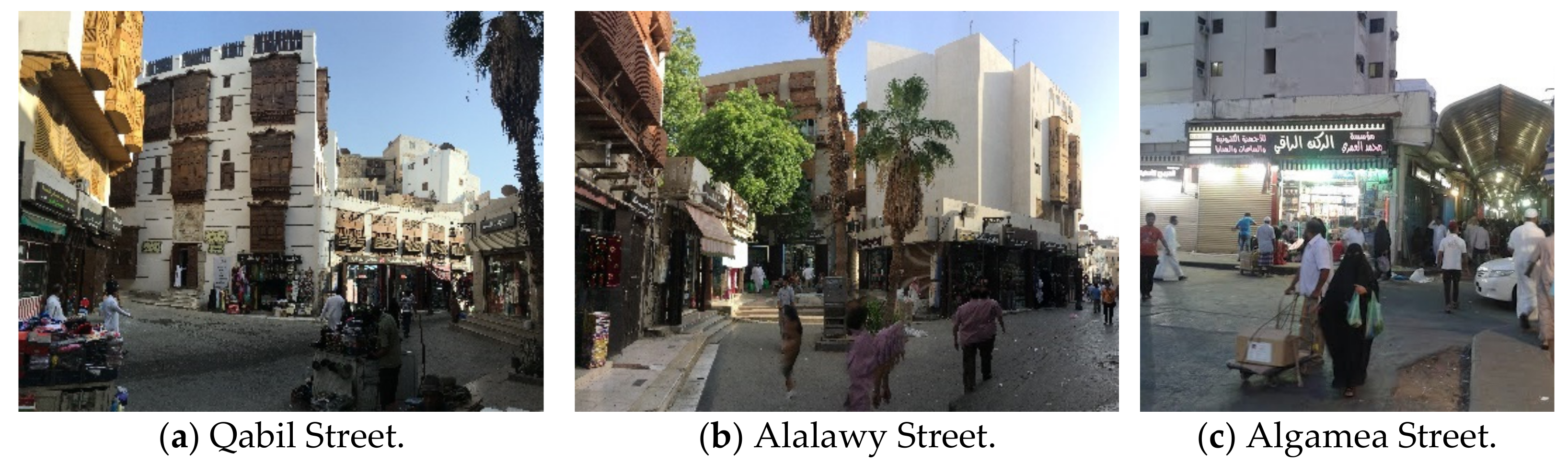
Furthermore, Historic Jeddah “Albalad” is considered the region’s last preserved original urban context. Figure 21 illustrates historic subdistricts and the unique premodern urban landscape, with narrow irregular alleys and small public spaces. The pictures in Figure 22 illustrate the urban character, diverse, multicultural population, and active, well-maintained Alalawy Street—vibrant public spaces that still play a significant cultural symbology role in the local community.
5.2.2. Conservation Activities
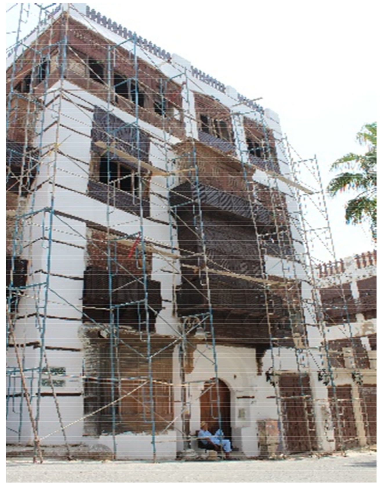
Efforts to maintain, conserve, and protect the Albalad area has continued through the last decades. In the 1970s, the area was subject to urban upgraded plans where new malls and office buildings replaced the coastal sector of the site. The city walls and gates were removed to ease the accessibility, and a new main road, “Al-Dahab Street”, created parallel to the sea, was constructed to meet the growing traffic demand requirements. Some buildings were subject to significant restoration, and three of the city gates and the remaining city walls were restored [51,57]. From 2003 to 2011, the King Abdul Aziz Project for the Conservation of the Historic District of Jeddah was launched at the organizational and administrative levels. Policies related to heritage buildings were developed. The Department of Architectural Development was established in the region, which formed the nucleus of the current Jeddah Historic District Municipality. A reference guide was adopted to restore heritage buildings and storefronts. The heritage buildings in the Jeddah Historic District Municipality complex were also restored [54,57].
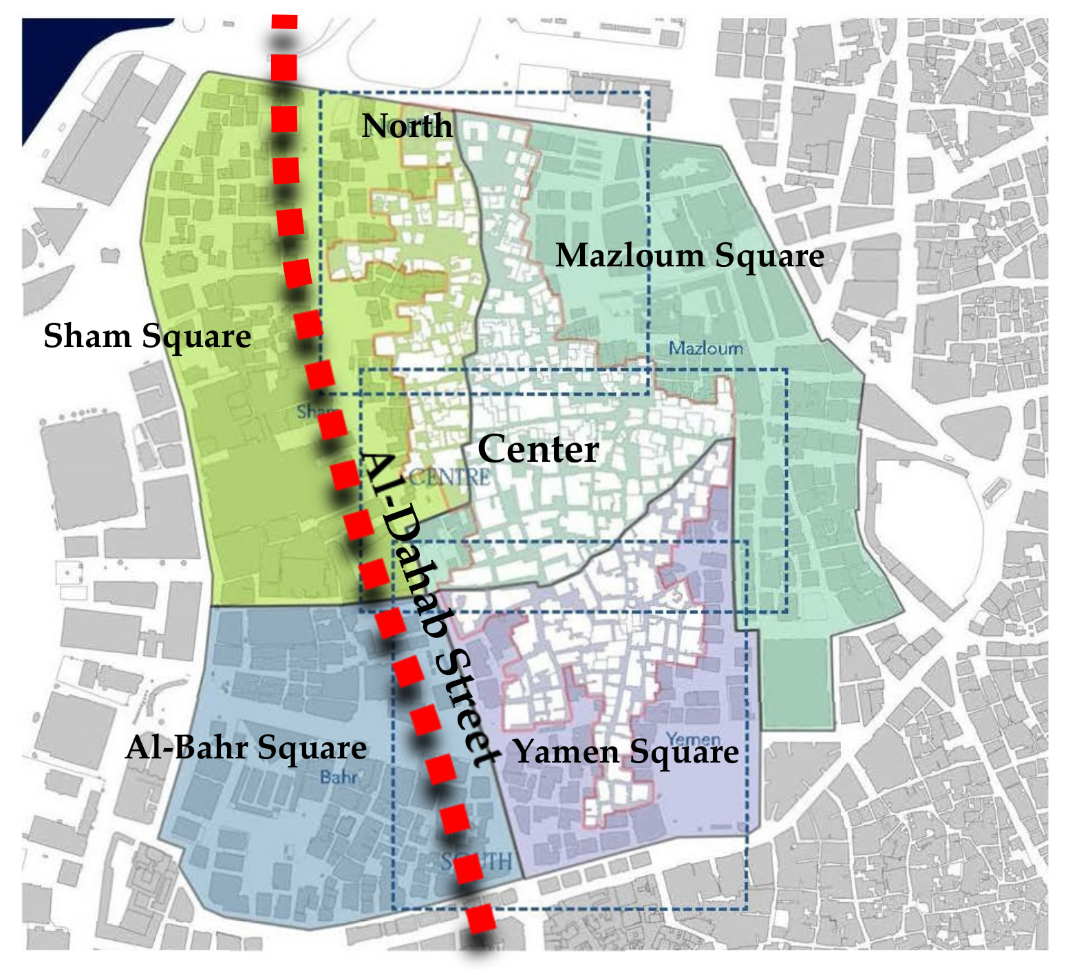
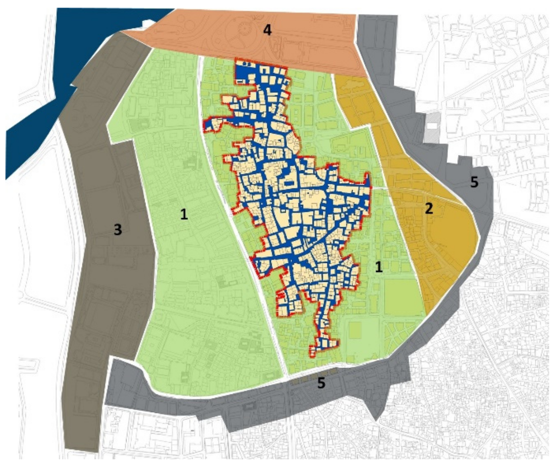
Moreover, through collaborative efforts between the municipality and the wealthy merchants within the city, some residential buildings, mosques, rabats, and markets were restored. Parallel to these efforts, a major urban landscape project was carried out to update spaces within the area. This project includes unifying the colors and size of the shop signs, adding designed lighting units and infrastructure, implementing the first phase of the firefighting network, maintaining the alleys’ paving work, and reducing the vehicle traffic within the area [22,58]. In 2012, a new urban legislative framework was enforced, providing legal tools to control the speculative movements that once triggered the loss of some historic buildings. Figure 23 shows the protected urban zone and its neighboring four districts. Each one of these districts follows different building regulations. In 2014, the site was granted UNESCO World Heritage status; several traditional buildings have been restored and opened to the public [51]. In 2019, the Saudi crown prince issued a royal decree to restore 50 historic buildings within the historical site [57].
5.2.3. Current Urban Management Plans
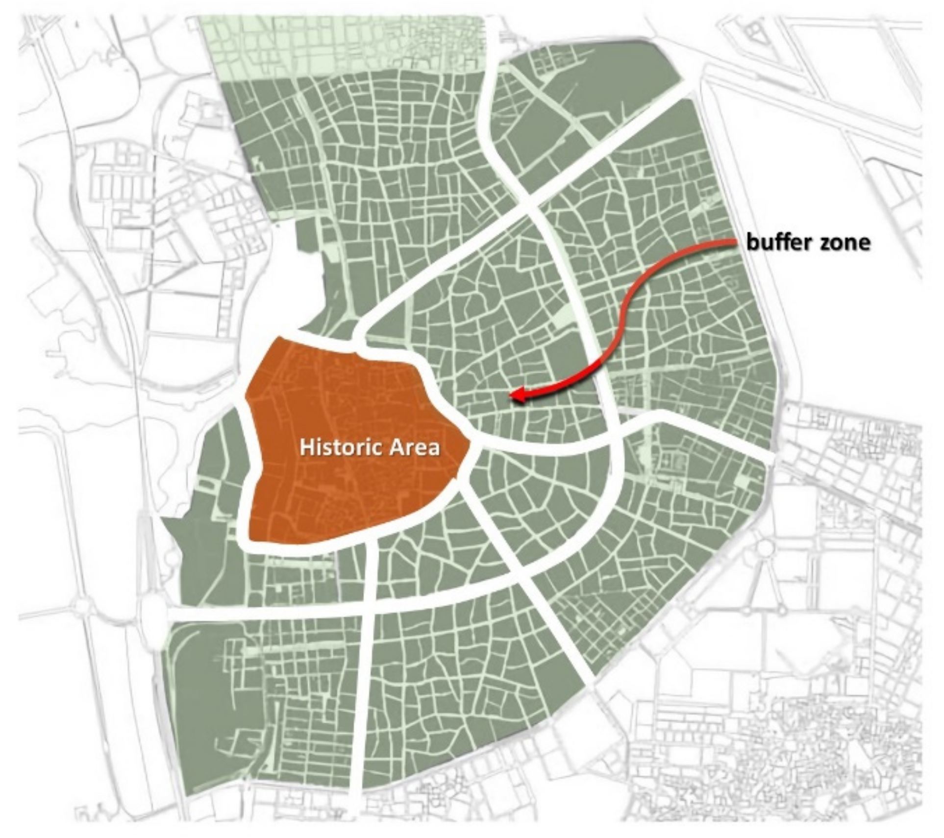
UNESCO did not list the whole area but selected a group of buildings. As a result, there are two different lists of heritage buildings, one listed by the municipality and one listed by UNESCO. Based on this, the protection system divides the urban area into four categories [25,59]. Figure 24 illustrates these categories and what Jeddah Municipality defined a larger urban ring as a transitional buffer area around the perimeter of the area listed by UNESCO. This area comprises the 1950s and1960s’ expansion of Jeddah beyond the city walls. Building regulations for this outer “ring” aimed at creating a smooth transition between the historic area and the city’s modern designed expansion. This urban ring development program creates large-scale structured urban blocks [25,51]. The plan aims to increase accessibility to the inner neighborhoods while preserving the original organic urban fabric, land use, building heights, and densities. Moreover, it targeted updating infrastructure and providing all the necessary social and technical infrastructure to the residents [54].
5.2.4. Impact of Implemented Development Actions
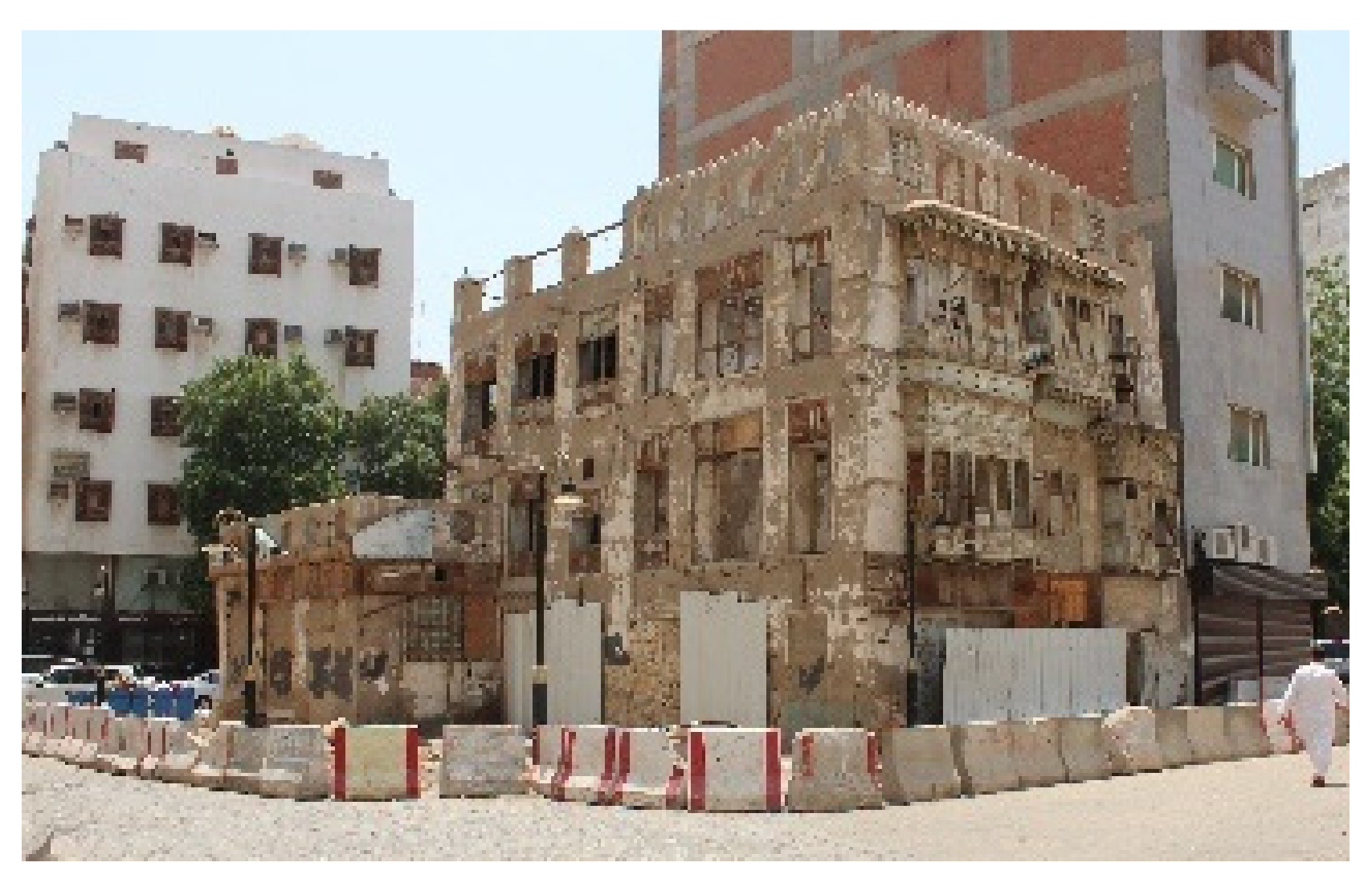
The enforced land-use legalization for ground floors as commercial and the first floor as offices helped create vital active spaces during shop working hours [29,30,31,32,33]. The typical floor spaces did not attract companies to utilize the traditional residential spaces with tiny rooms and poor utilities. Shop renters used the spaces informally as a store and housing for their workers. This use endangered the valuable, fragile buildings and created risky alleys to walk through after the shops’ opening hours [1]. It is worth mentioning that several fires in the last five years resulted in the demolition of several of the listed buildings [57]. At the same time, buildings that were subject to maintenance were locked without any usage, resulting in the fast decay of these buildings. The building regulations for areas one and two, shown on the map in Figure 23, permit owners to have up to twelve floors to combine plots to achieve a larger plot area. This building permit system negatively impacted the narrow alleys’ homogenous skyline and width-to-height ratios. Otherwise, the urban spaces are well maintained and vibrant, especially during the Ramadan night season, when daily activities extend for a whole month in the northern part of the historic area. The area is still considered the city’s wholesale market for honey, perfume, cloth, toys, etc. [44,51]. Table 3 summarizes the subjective assessment of the implemented conservation strategies and the ongoing activities in the Albalad area of Jeddah city.
6. Discussion
The paper proposed an assessment framework for urban heritage conservation that links four different conservation parameters to seven aspects of urban qualities. The first conservation parameter defines the urban heritage and its attributes; the second parameter is the assessment of planning, conserving, and managing the urban heritage; the third parameter is the institutional, communal, legal, and sustainable strategies for implementation; the fourth parameter is the stakeholders’ management and the governance framework. The paper proposed twenty practices that may impact the resulting urban quality [39,40,41,61]. Successful urban heritage conservation was suggested to be assessed through its urban qualities. Seven aspect areas were identified through the study. The first is the environmental aspects; the second is the economic aspects; the third is the social aspects; the fourth is the services to support the expected activities; the fifth is the accessibility and linkage of the developed area; the sixth is culture and image of the resulted urban heritage; the seventh is the infrastructure needed to support the predicted number of visitors. The paper suggested thirty-three indicators for measuring urban conservation success. The impact of each development parameter on the different quality indicators was presented where five different shades were used to represent the strength of the relation between them [1,29,41,42]. The literature review and case studies’ investigation showed that, except in Qatar, none of the conservation authorities of the Arab countries had adopted the Historic Urban Landscape approach in their heritage conservation scope or policies yet [33]. Urban heritage areas and their neighboring districts within certain historic cities in many developing countries suffer from deteriorated social fabric, low-standard services, and utility problems [62]. Urban heritage areas and their neighboring districts within the case study urban areas suffered from deterioration, low-standard services, and utility problems [62]. The planning departments of local municipalities were responsible for these historic urban areas [63]. Urban planning authorities spent continuous efforts upgrading them and solving their urban problems [23].
In Amman’s case, the final strategic plan of the city recognized the historic area as a cultural asset and touristic commodity [48]. The investigation of Amman city shows that rational urban management policies and suitable adaptive reuse are key to prosperous sustainable historic urban heritage. The historic area has been subject to subsequent management plans since 1995 [30]. These plans were oriented to improve living conditions, create more job opportunities, ease traffic congestion, and improve environmental quality. Increasing tourism activities were embedded within the current management plan [64]. The development in Amman city in general and the Albalad area, in particular, was based directly on foreign aid, and actions were selected based on the significance of their impacts on residents [37]. Facilities to support cultural and touristic activities were developed, and adaptive reuse for buildings was implemented. The result was a vibrant urban and commercial area. However, Islamic and Roman monuments in the surrounding areas are still undeveloped and require dedicated funds for conservation [13]. Gad argues that ring roads are ineffective in defining urban area boundaries and their role as catalysts for urban sprawls [23]. Analyzing the Amman ring road impacts the Albald area positively by decreasing traffic congestion since the surrounding topology already defines the area.
The significance of the historic area of Jeddah allows it to play a significant role in boosting the city’s economy [60]. Jeddah’s historic area had a dedicated administration for the area management, but up to 2020, the effort still focused on restoring and preserving the listed buildings. Like many other Arab cities, there is no clear multilevel sustainable strategic vision for urban heritage [58]. Mandeli argues that the Jeddah planning authority’s adoption of Western approaches to city planning was at the expense of culture and traditions, failing to preserve the historic center or render the nearby Corniche to the local context [63]. Throsby suggested an independent administrative structure, as in the case of the Petra site in Jordan, rather than leaving it to be managed by local management with limited resources. The Kingdom’s newly adopted 2030 vision considers the historic area as a tool for development and heritage as a national asset [57]. Such areas usually require expensive solutions beyond the local governments’ financial resources, resulting in partial solutions or long-term phased development plans [65]. The case of Jeddah proved that fund availability is not enough. As fire accidents hit the historic area several times over in recent years resulting in the loss of several historical buildings, the Crown Prince, earlier this year, provided funds to conserve fifty buildings of the listed heritage buildings [62]. There is a need for a legal and institutional framework to maintain the sustainability of the conserved heritage urban areas [60,62]. Neither the selected adaptive reuse for the listed heritage buildings in Jeddah, as shopping ground floors and offices for typical floors, nor the financial incentives for owners of heritage buildings provide the desired sustainability. On the contrary, implemented planning regulations and building codes gave owners of heritage buildings motives to neglect and even demolish their buildings to receive a higher floor area ratio and different floor usability [9]. These regulations changed the urban character of the historic area and its urban buffer. [63] Despite some recent and ongoing improvements, area residents’ survey results showed the need for a better infrastructure regarding sewerage, lighting, parking, and waste disposal. Throsby et al. concluded that there is no strategic planning for the area based on giving permission for many large shopping centers without facilitating the required parking facilities. This worsens the traffic congestion within the historic area [60].
Upon comparing the urban management plans in Amman and Jeddah it can be concluded that good design and details can produce a positive image, irrespective of the richness of the used materials. Moreover, Amman benefited from being part of GAM, allowing the historic area to be part of the strategic vision of the city master plan [19,48]. In Jaddah, where a dedicated district administration was initiated, limited resources and planning expertise did not help as much as the administration structure of Amman did [60]. Mateu et al. argue that the management decentralization of historic urban areas is inefficient and unreasonable. He also suggested a participatory governance approach, where the relevant national institutions’ representatives and local bodies can work together with the key local stakeholders to develop and manage urban heritage [66].
The study proved that adaptive reuse should be selected carefully. Itohan et al. proposed a performance-based adaptive reuse selection framework to achieve sustainable and resilient urban areas. This suggested framework prioritizes these aspects as follows: Economic sustainability, heritage conservation, socio-cultural, historic building usability, and buildings regulations [67].
Miriam concluded from her survey on a case study in Morocco that development projects that impose strict regulations always face dissatisfaction and resistance from residents because of the lack of freedom in living within traditional socio-cultural norms [20]. The investigated case studies showed that adopting a legal and financial multi-dimensional framework with an area of freedom and participation is essential for any sustainable urban heritage conservation plans [60]. The study showed that conservation activities improve the overall market value of the proprieties within the area and attract a new category of residents [68]. The motive for the local community is the sense of belonging that can be achieved through programs of preserving the social structure and conserving local heritage. Such programs require smaller budgets than conserving the physical environment and can be economically sustainable [30,44]. The study investigation’s most important lesson was that sustaining and preserving the cultural and social aspects does not require capital investment. As much as conserving the physically built environment, social programs raise the sense of belonging and cultural identity within the local community [14], such as Ramadan nights organized by the Saudi Antiquities Authorities in the Albalad area in Jeddah and the cultural events and activities held in the Albalad area in Amman. These programs proved to be very helpful in raising the local community’s awareness of their heritage and gaining their willingness to participate in the conservation process [1,13].
Urban spaces within historic areas are not built to accommodate contemporary traffic, and reducing traffic congestion must be one of the primary targets of any development plan, which will have a direct environmental impact through reducing air pollution [7,21]. Moreover, the literature review indicates that improving the quality of the outdoor spaces and enhancing the public space image increase the overall market value of the properties within the area and attract a new category of residents and activities [32,36].
Literature on the subject implies that urban buffer areas should be treated so that smoother transactions can be facilitated between the historic urban and the rest of the city urban areas [25]. Gad concluded that planning mega projects in urban areas could significantly change their surrounding areas’ land use [23]. This conclusion pushed heritage decision-makers toward having such projects within urban areas surrounding the historical centers. He also argues that urban growth would occur at the expense of valuable resources, either green space or cultural assets within or surrounding the city. This argument alerts the heritage authorities to initiate protective legalization for heritage areas as soon as they are defined. Dailia suggested planners apply contemporary trends while engaging the urban heritage through analysis to end up with a balanced urban management plan that satisfies the technical, environmental, and cultural needs [18]. Moreover, she suggests bridging the gap between the need for shaded winding streets and wide, straight streets to facilitate vehicles’ movement through utilizing the traditional environmental techniques and local features creating “place-related social identity.” [18].
“What can be measured can be accomplished”: This quote was one of the fundamental outputs of the Millennium Development Goals (MDGs) final report, adopted by the United Nations’ Millennium Declaration in 2000 [69]. The study showed that the best way to perform conservation of historical urban areas is to embed it within the urban planning strategies of the city [67,68]. Therefore, the suggested objective and subjective indicators need to be used as soon as the conservation objectives are defined. Data collection of all the existing conditions is required before any implementation efforts. The data are the base for accurately measuring the outcomes [34].
Miriam argues that development policies that promote residents’ participation in Morocco were not entirely successful. Moreover, she concluded that achieving successful development initiatives with residents’ participation rarely reaches its planned objectives and constitutes a repeated dilemma for urban management authorities [20]. She suggested that engaging residents at the early stages of the development project would allow them to voice their requirements, bridge the gap between their needs and the planners’ vision, build trust among the stakeholders, and ensure the delivery of what was promised. Moreover, the case study analysis proved that local awareness and public participation contributed positively to improving and revitalizing the place’s character. Indeed, urban heritage is an essential part of any local culture. Residents’ sense of belonging and pride can be the driving force for any conservation efforts. Residents’ participation is necessary for any urban management plans. Locals should be part of the team to identify the heritage objects, define conservation priorities, management plans, and activities. Policymakers must induce regulations that ensure the effective conservation of cultural values in such historic city centers.
Consequently, these cultural values can generate more attraction to those centers and, hence, sustain these places. Some cultural activities, such as social gathering at night, requires special urban qualities to support these social activities. Table 4 summarizes the study recommendations for conservation authorities and city planning departments.
7. Conclusions
The main research findings and interpretations are:
- The proposed assessment framework showed that conservation parameters could be assessed through the resulting urban qualities.
- The presented parameters of Urban Heritage Conservation need to be defined and followed from the early stages of the project.
- A set of assessment indicators needs to be defined as soon as the strategic vision is identified. The proposed framework provides a good base for such an assessment process.
- It has been proven that the conservation efforts of most Arab cities’ historical centers are outdated in benefiting from the historic urban landscape approach and intangible cultural assets.
- Case studies’ analysis shows that social activities and heritage-based events can help build a sense of belonging and a sense of place. Seasonal programs with weekly events of various types can bring visitors from different backgrounds to the targeted areas and help promote them. Moreover, it would build the required image of the place.
- Creating outdoor quality spaces is a good step in developing the historic urban area, but it will not bring visitors. Creating activities, adopting new uses for buildings, adding commercial activities, restaurants, cafes, and seating areas can create a vital active place.
- Adaptive reuse for historic buildings should be selected carefully. Such reuse should offer the safety and security of the historic buildings simultaneously; it should support their sustainability. Selected functions could significantly influence the livability and vitality of the open spaces between these buildings.
- Case studies suggested that repeated efforts to accommodate the car traffic systems within the historic urban spaces proved to fail. Creating pedestrian-friendly urban areas contributes positively to safe, less congested, and less polluted urban areas.
- The Amman case study analysis proved that creating a ring road around the area eases traffic congestion and environmental pollution. Providing a mass-transit system linked the area to the neighboring districts. Having parking areas at the area borders contributes to easing traffic.
- The case of Amman proved that having a public transit system for the historic area can encourage visitors to leave their cars on the area’s borders.
- The Jeddah case study showed that the unavailability of mass transit and the enforcement of a paid parking policy along the streets around the area pushed visitors to park their cars inside the historic area narrow alleys causing a congested traffic jam, where pedestrians and vehicles share the same spaces without any separation.
- A legal and economic framework must be defined and put to action before any conservation efforts start. This framework should deal with ownership issues and the buildings’ regulations to guarantee the security of these buildings.
The limitations of this research are that the case study analysis was based on assessing the resulting urban quality and not examining the impact of the process aspects on the quality indicators since both did not fully use the UHC approach. Some of the indicator data were not available at this research stage. The next stage is expected to include residents’ surveys and secondary data. For more validation, full implementation of the framework in assessing UHC development should be used to examine a case study that implements the HUL approach. Further research is needed in two main areas. The first is investigating the economic bases of urban heritage conservation projects in terms of their validity, alternatives, impacts on the local community prosperity, and the generated wealth distribution. The second area is to examine more specialized indicators in the social and economic fields.
Funding
This research received no funds.
Institutional Review Board Statement
Not Applicable.
Informed Consent Statement
Not applicable.
Conflicts of Interest
The author declares no conflict of interest.
References
- Badawy, S.; Shehata, A.M. Sustainable Urban Heritage Conservation Strategies—Case Study of Historic Jeddah Districts. In Cities’ Identity through Architecture and Arts; Anna Catalani, Z.N., Versaci, A., Hawkes, D., Bougdah, H., Sotoca, A., Ghoneem, M., Trapani, F., Eds.; Routledge: Cairo, Egypt, 2020; Volume 1, p. 17. [Google Scholar]
- Al-Saffar, M. Urban heritage and conservation in the historic center of Baghdad. Int. J. Herit. Arch. Stud. Repairs Maint. 2017, 2, 23–36. [Google Scholar] [CrossRef]
- Yildirim, E.; Culture in the Implementation of the 2030 Agenda: A Report by Culture 2030 Global Goals Movement. ICOMOS. 2018, p. 2. Available online: https://www.icomos.org/images/DOCUMENTS/Secretariat/2021/SDG/ICOMOS_SDGs_Policy_Guidance_2021.pdf (accessed on 12 October 2021).
- UNESCO. Item 12 of the Provisional Agenda: Revision of the Operational Guidelines. In Convention Concerning The Protection of the World Cultural and Natural Heritage—Extended Forty-Fourth Session; 2021; Available online: https://whc.unesco.org/document/173608 (accessed on 8 October 2021).
- UNESCO. Adopted decisions during the 42nd session of the World Heritage Committee. In Convention Concerning The Protection of the World Cultural and Natural Heritage-Forty-Second Session; WHC/18/42.COM/18; 2018; Available online: https://whc.unesco.org/document/168796 (accessed on 8 October 2021).
- Mandeli, K. Interpretation of Urban Design Principles in a Traditional Urban Environment: The Role of Social Values in Shaping Cities. Ph.D. Thesis, University of Southern California, Los Angeles, CA, USA, 1993. [Google Scholar]
- Jasim, S. The Issue of Standardization in Tradition Urban Fabric of Islamic City. In Proceedings of the 13th International Conference “Standardization, Prototypes, and Quality: A Means of Balkan Countries’ Collaboration", Brasov, Romania, 3–4 November 2016. [Google Scholar]
- Khalaf, R.W. Traditional vs. modern Arabian morphologies. J. Cult. Herit. Manag. Sustain. Dev. 2012, 2, 27–43. [Google Scholar] [CrossRef]
- Nasralden, M.K. The Transformation of Public Spaces in Saudi Cities: A Case Study of Jeddah. In Proceedings of the Saudi International Conference, Coventry, UK, 23–26 June 2011. [Google Scholar]
- Mahmoud, M.L. The Egyptian City Centers in the Islamic Era: Image Analysis, Evaluation, and Contemporary Reflections. J. Eng. Sci. 2020, 48, 538–553. [Google Scholar]
- Correia Jorge, M.T. Traditional Islamic Cities Unveiled: The Quest for Urban Design Regularity. Gremium. Mag. 2015, 2. Available online: https://editorialrestauro.com.mx/traditional-islamic-cities-unveiled-the-quest-for-urban-design-regularity/ (accessed on 20 October 2021).
- AlSayyad, N. Space in an Islamic City: Some Urban Design. J. Archit. Plan. Res. 1987, 4, 11. [Google Scholar]
- Hannah, D. The Rights to Amman: An Exploration of the Relationship between a City and Its Inhabitants. Master’s Thesis, Leiden University, Leiden, The Netherlands, 2021. [Google Scholar]
- Yung, E.H.K.; Zhang, Q.; Chan, E.H.W. Underlying social factors for evaluating heritage conservation in urban renewal districts. Habitat Int. 2017, 66, 135–148. [Google Scholar] [CrossRef]
- Ertan, T.; Eğercioğlu, Y. Historic City Center Urban Regeneration: Case of Malaga and Kemeraltı, Izmir. Procedia Soc. Behav. Sci. 2016, 223, 601–607. [Google Scholar] [CrossRef] [Green Version]
- Abu-Hamdi, E. Neoliberalism as a site-specific process: The aesthetics and politics of architecture in Amman, Jordan. Cities 2017, 60, 102–112. [Google Scholar] [CrossRef]
- Saeed, Z.O.; Almukhtar, A.; Abanda, H.; Tah, J. Mosul City: Housing Reconstruction after the ISIS War. Cities 2022, 120, 103460. [Google Scholar] [CrossRef]
- Mohamed, D.H.I.L. Cairo: An Arab city transforming from Islamic urban planning to globalization. Cities 2021, 117, 103310. [Google Scholar] [CrossRef]
- Alnsour, J. Managing urban growth in the city of Amman, Jordan. Cities 2016, 50, 93–99. [Google Scholar] [CrossRef]
- Keep, M.; Montanari, B.; Greenlee, A.J. Contesting “inclusive” development: Reactions to slum resettlement as social inclusion in Tamesna, Morocco. Cities 2021, 118, 103328. [Google Scholar] [CrossRef]
- Abdeljawad, N.; Nagy, I. Urban Environmental Challenges and Management Facing Amman Growing City. Rev. Int. Geogr. Educ. 2021, 11, 2021. [Google Scholar] [CrossRef]
- Abdulaal, W.A. Large urban developments as the new driver for land development in Jeddah. Habitat Int. 2012, 36, 36–46. [Google Scholar] [CrossRef]
- Jaad, A.; Abdelghany, K. The story of five MENA cities: Urban growth prediction modeling using remote sensing and video analytics. Cities 2021, 118, 103393. [Google Scholar] [CrossRef]
- Koorosh, S.S.; Sza, I.; Ahad, F. Evaluating Citizens’ Participation in the Urban Heritage Conservation of Historic Area of Shiraz. Procedia Soc. Behav. Sci. 2015, 170, 390–400. [Google Scholar] [CrossRef] [Green Version]
- UNESCO World Heritage Centre. Developing Historic Cities Key Understanding and Taking Actions; UNESCO: Paris, France, 2014. [Google Scholar]
- Hoff, A.G. Sacred Placemaking and Urban Policy the Case of Tepoztlán, Mexico. Ph.D. Thesis, The University of California, Irvine, CA, USA, 2020. [Google Scholar]
- UNESCO. Fifteenth General Assembly of States Parties to the Convention Concerning the Protection of the World Cultural and Natural Heritage; UNESCO: Paris, France, 2005. [Google Scholar]
- Zancheti Silvio Mendes, K.S. Measuring Heritage Performance. In Proceedings of the In 6th International Seminar on Urban Conservation, Recife, Brazil, 29–31 March 2011. [Google Scholar]
- Janset, S. Al-Balad as a Place of Heritage: Problematizing the Conceptualization of Heritage in the Context of Arab Muslim Middle East. Ph.D. Thesis, University College London, London, UK, 2011. [Google Scholar]
- Richards, G.; King, B.; Yeung, E.Y.M. Experiencing culture in attractions, events and tour settings. Tour. Manag. 2020, 79, 104104. [Google Scholar] [CrossRef]
- Francesca, N. The Role of Cultural Heritage in Sustainable Development Multidimensional Indicators as Decision Making Tool Enhanced Reader. Sustainability 2017, 9, 28. [Google Scholar]
- UNESCO World Heritage Centre. Recommendation on the Historic Urban Landscape-Report of the Second Consultation on Its Implementation by the Member States; UNESCO: Paris, France, 2019. [Google Scholar]
- UNESCO World Heritage Centre. Operational Guidelines for the Implementation of the World Heritage Centre; UNESCO: Paris, France, 2019; pp. 1–177. [Google Scholar]
- Australia ICOMOS. The Burra Charter Process, Flow Chart from the Australia ICOMOS Burra Charter. 2013. Available online: https://australia.icomos.org (accessed on 18 November 2021).
- Ashour, K.N. Urban Regeneration Strategies in Amman’s Core: Urban Development and Real Estate Market. Ph.D. Thesis, Dortmund Technical University, Dortmund, Germany, 2016. [Google Scholar]
- Pietrostefani, E.; Holman, N. The politics of conservation planning: A comparative study of urban heritage making in the Global North and the Global South. Prog. Plan. 2020, 152, 100505. [Google Scholar] [CrossRef]
- Katapidi, I. Heritage policy meets community praxis: Widening conservation approaches in the traditional villages of central Greece. J. Rural. Stud. 2020, 81, 47–58. [Google Scholar] [CrossRef]
- Veldpaus, L.; Roders, A.P. Historic Urban Landscapes—An Assessment Framework. In Proceedings of the 33rd Annual Meeting of the International Association for Impact Assessment, Calgary Stampede B.M.O Centre, Calgary, AB, Canada, 13–16 May 2013. [Google Scholar]
- Silva, A.T.; Roders, A.P. Cultural Heritage Management, and Heritage (Impact) Assessments. In Proceedings of the Joint CIB W070, W092 & TG72 International Conference on Facilities Management, Procurement Systems, and Public-Private Partnership, Cape Town, South Africa, 23–25 January 2012. [Google Scholar]
- Chau, K.W.; Choy, L.H.T.; Lee, H.Y. Institutional arrangements for urban conservation. Neth. J. Hous. Environ. Res. 2018, 33, 455–463. [Google Scholar] [CrossRef] [Green Version]
- Samargandi, S. Integral Placemaking in Sensitive Heritage Sites for Successful Cultural Tourism. Master’s Thesis, Effat University, Jeddah, Saudi Arabia, 2018. [Google Scholar]
- Yousof, A.S. Plaza Design Criteria—Applied Study of South East Plaza of the Grand Mosque at Makkah. Master’s Thesis, Umm Al-Qura University, Makkah, Saudi Arabia, 2018. [Google Scholar]
- Shehata Ahmed, A.E. Impact of Urban Development Policies on the Produced Urban Characteristics. In Proceedings of the 3rd International Conference on Conservation of Architectural Heritage (C.A.H.), Aswan, Egypt, 19–22 February 2019. [Google Scholar]
- Smith, L. Uses of Heritage; Routledge: New York, NY, USA, 2006. [Google Scholar]
- Beauregard, R.A.; Marpillero-Colomina, A. More than a master plan: Amman 2025. Cities 2011, 28, 62–69. [Google Scholar] [CrossRef]
- Shwartz, A.; Turbé, A.; Julliard, R.; Simon, L.; Prévot, A.-C. Outstanding challenges for urban conservation research and action. Glob. Environ. Chang. 2014, 28, 39–49. [Google Scholar] [CrossRef]
- Jordanian Department of Statistics. Amman Vital Statistics: Jordan Statistical Yearbook. 2020. Available online: http://dosweb.dos.gov.jo/databank/yearbook/YearBook_2020.pdf (accessed on 20 November 2021).
- Abu-Ghazalah, S. Le Royal in Amman: A new architectural symbol for the 21st century. Cities 2005, 23, 149–159. [Google Scholar] [CrossRef]
- Jordanian Department of Statistics. Tourism Statistics: Jordan Statistical Yearbook. 2020. Available online: http://dosweb.dos.gov.jo/products/jordan-statistical-yearbook-2020/ (accessed on 20 November 2021).
- Jordanian Department of Statistics. Population Jordan Statistics. 2018. Available online: http://dosweb.dos.gov.jo/databank/yearbook/YearBook_2018.pdf (accessed on 20 November 2021).
- Ministry of Municipal Affairs. Future Saudi Cities Programme City Profiles Series: Jeddah City Profile; Ministry of Municipal Affairs: Jeddah, Saudi Arabia, 2019. [Google Scholar]
- Alshoaibi, A. Albeeah Architects and Engineers. In Proposed Urban Strategy Report; Jeddah Governorate: Jeddah, Saudi Arabia, 2004. [Google Scholar]
- Bokhari, A.Y. Conservation in the Historic District of Jeddah. In Proceedings of the Redeveloping and Rebuilding Traditional Areas, Boston, MA, USA, 16–20 August 1982; pp. 60–68. [Google Scholar]
- Saudi Heritage Commission. Executive Summary of State of Conservation Report—Kingdom of Saudi Arabia World Heritage Sites; UNESCO: Jeddah, Saudi Arabia, 2020. [Google Scholar]
- Mady Mohamed, E.M. Investigating the Environmental Performance of the Wind Catchers in Jeddah. WIT Trans. Built Environ. 2018, 177, 11. [Google Scholar]
- Geographic Information Center at Jeddah Minucipality. Map of the Nominated Property and the Buffer Zone of Historic Jeddah; Saudi Heritage Commission: Al Bahah, Saudi Arabia, 2012. [Google Scholar]
- UNESCO World Heritage Centre. State of Conservation: Historic Jeddah, the Gate to Makkah (Saudi Arabia); UNESCO: Paris, France, 2021. [Google Scholar]
- Ahmed, M.K.N. Public Spaces in a Contemporary Urban Environment: Multi-Dimensional Urban Design Approach for Saudi Cities. Ph.D. Thesis, University of Newcastle, Newcastle, UK, 2011. [Google Scholar]
- The Supreme Commission for Tourism, Kingdom of Saudi Arabia. National Tourism: Development Project Phase 1: General Strategy; The Supreme Commission for Tourism: Riyadh, Saudi Arabia, 2002. [Google Scholar]
- Throsby, D.; Petetskaya, K. Heritage-led urban rehabilitation: Evaluation methods and an application in Jeddah, Saudi Arabia. City, Cult. Soc. 2021, 26, 100397. [Google Scholar] [CrossRef]
- Landorf, C. A Framework for Sustainable Heritage Management: A Study of U.K, Industrial Heritage Sites. Int. J. Heritage Stud. 2009, 15, 494–510. [Google Scholar] [CrossRef]
- Lai, L.W.C.; Lorne, F.T. Sustainable Urban Renewal and Built Heritage Conservation in a Global Real Estate Revolution. Sustainability 2019, 11, 850. [Google Scholar] [CrossRef] [Green Version]
- Mandeli, K. Public space and the challenge of urban transformation in cities of emerging economies: Jeddah case study. Cities 2019, 95, 102409. [Google Scholar] [CrossRef]
- Ali Al-Shomali, M.A. Establishing Evaluation Criteria of Modern Heritage Conservation in Historic City Centers in Jordan. Int. J. Environ. Sci. Dev. 2020, 11, 561–571. [Google Scholar] [CrossRef]
- Udeaja, C.; Trillo, C.; Awuah, K.G.; Makore, B.C.; Patel, D.A.; Mansuri, L.E.; Jha, K.N. Urban Heritage Conservation and Rapid Urbanization: Insights from Surat, India. Sustainability 2020, 12, 2172. [Google Scholar] [CrossRef] [Green Version]
- Mirzakhani, A.; Turró, M.; Jalilisadrabad, S. Key stakeholders and operation processes in the regeneration of historical urban fabrics in Iran. Cities 2021, 118, 103362. [Google Scholar] [CrossRef]
- Aigwi, I.E.; Ingham, J.; Phipps, R.; Filippova, O. Identifying parameters for a performance-based framework: Towards prioritising underutilised historic buildings for adaptive reuse in New Zealand. Cities 2020, 102, 102756. [Google Scholar] [CrossRef]
- Jayantha, W.M.; Yung, E.H.K. Effect of Revitalisation of Historic Buildings on Retail Shop Values in Urban Renewal: An Empirical Analysis. Sustainability 2018, 10, 1418. [Google Scholar] [CrossRef] [Green Version]
- United Nations. The Millennium Development Goals Report; United Nations: New York, NY, USA, 2015. [Google Scholar]
Figure 1.
Historic urban fabric of three Arab cities having the same inner-oriented openings and narrow irregular shaded pedestrian networks. (a) Historic urban fabric of Rabat; (b) historic urban fabric of Cairo; (c) historic urban fabric of Damascus.
Figure 1.
Historic urban fabric of three Arab cities having the same inner-oriented openings and narrow irregular shaded pedestrian networks. (a) Historic urban fabric of Rabat; (b) historic urban fabric of Cairo; (c) historic urban fabric of Damascus.

Figure 2.
(a) Services in historic Jeddah allays, (b) services in the historic area of Amman, (c) outdoor electric systems in historic Jeddah.
Figure 2.
(a) Services in historic Jeddah allays, (b) services in the historic area of Amman, (c) outdoor electric systems in historic Jeddah.

Figure 3.
Two photos demonstrate the difference in heights between old and new buildings, causing congested traffic networks.
Figure 3.
Two photos demonstrate the difference in heights between old and new buildings, causing congested traffic networks.

Figure 4.
A satellite image showing some of the newly added massive buildings to the historic area of Jeddah.
Figure 4.
A satellite image showing some of the newly added massive buildings to the historic area of Jeddah.

Figure 5.
Successful sustainable UHC aspects.

Figure 6.
Successful sustainable UHC attributes.

Figure 7.
Amman City’s urban growth (1946–2005) [19].
Figure 7.
Amman City’s urban growth (1946–2005) [19].

Figure 8.
Historic urban features of Amman City. Dated 1931. Source: Adapted from Department of Lands and Survey, Transjordan cited in [19], reproduced by the author.
Figure 8.
Historic urban features of Amman City. Dated 1931. Source: Adapted from Department of Lands and Survey, Transjordan cited in [19], reproduced by the author.

Figure 9.
Spatial distribution of “Albala” Conservation Action Plan.

Figure 10.
First-floor entertaining activities doubled the commercial use of the area. Source: The Author.
Figure 10.
First-floor entertaining activities doubled the commercial use of the area. Source: The Author.

Figure 11.
Specialized shopping and markets. Source: Amman institute as cited by Ashour [36].
Figure 11.
Specialized shopping and markets. Source: Amman institute as cited by Ashour [36].

Figure 12.
Commercial activities created vibrant streets. Source: The Author.

Figure 13.
Food, touristic gift shops, cultural events.

Figure 14.
Allowing Hawkers to use the sidewalks creates more jobs: The Author.

Figure 15.
Many migrants enjoy the benefits of the commercial center. Source: The Author.

Figure 16.
Preserving the contours maintained the city’s original character. Source: The Author.

Figure 17.
Alleys have shaders with different designs. Source: The Author.

Figure 18.
The physical conditions of the nearby Castel mountain archeological site.

Figure 19.
Historic Jeddah’s urban growth through the last five decades [33].
Figure 19.
Historic Jeddah’s urban growth through the last five decades [33].

Figure 20.
The listed buildings within the Albalad area [56].
Figure 20.
The listed buildings within the Albalad area [56].

Figure 21.
Districts of Albalad area.

Figure 22.
(a) Area’s urban & architectural unique character; (b) maintained urban spaces as in Alalawy Street, (c) commercial activities at the whole sale market in the Algamea street.
Figure 22.
(a) Area’s urban & architectural unique character; (b) maintained urban spaces as in Alalawy Street, (c) commercial activities at the whole sale market in the Algamea street.

Figure 23.
The buffer zone around the listed heritage where areas 1 to 5 represent different applied buildings regulations. [36].
Figure 23.
The buffer zone around the listed heritage where areas 1 to 5 represent different applied buildings regulations. [36].

Figure 24.
The buffer zone around the listed heritage [37].
Figure 24.
The buffer zone around the listed heritage [37].

Figure 25.
Commercial activities spread along all the narrow alleys.

Figure 26.
Ramadan nights, unified shop signage, and stylish lighting units enhance the image quality of the maintained spaces.
Figure 26.
Ramadan nights, unified shop signage, and stylish lighting units enhance the image quality of the maintained spaces.

Figure 27.
Narrow alleys turned into car parking.

Figure 28.
Tiled flooring, unified shop signage, and stylish lighting units.

Figure 29.
Buildings’ owners are not motivated to conserve their properties.

Figure 30.
Sample of the continuous efforts of the Conservation Authorities to maintain the listed buildings.
Figure 30.
Sample of the continuous efforts of the Conservation Authorities to maintain the listed buildings.

Table 1.
Areas and indicators of urban conservation impact assessment.
| Heritage Definition | UHC Project Objective | Utilized Strategies | Stakeholders Participation | ||||||||||||||||||
| Cultural values | Natural values | Attributes | Geographical setting | Identify | Assess | Conserve | Manage | Local values | Local needs | Regulatory systems | Regulatory measures | Environmental impact assessments | Participation processes | Capacity building | Sustainable socio-economic | Sustainable UHC | Policymaking. | Governance system | Management system | ||
| Social | Average income | ||||||||||||||||||||
| Crime rate | |||||||||||||||||||||
| No. of Job opportunities | |||||||||||||||||||||
| Sense of belonging | |||||||||||||||||||||
| Sense of pride | |||||||||||||||||||||
| Voluntary work | |||||||||||||||||||||
| Economic | Local Business Share | ||||||||||||||||||||
| Average Rent | |||||||||||||||||||||
| Tourism sector size | |||||||||||||||||||||
| Environment | Adaptive reuse | ||||||||||||||||||||
| Number of visitors | |||||||||||||||||||||
| Energy consumption | |||||||||||||||||||||
| Air pollution | |||||||||||||||||||||
| Services | Sanitation (Public toilets) | ||||||||||||||||||||
| Cafes & Seating | |||||||||||||||||||||
| Shopping | |||||||||||||||||||||
| Accessibility | Public transport. modes | ||||||||||||||||||||
| Parking lots | |||||||||||||||||||||
| Pedestrian-friendly | |||||||||||||||||||||
| Image | Rainstorm drainage | ||||||||||||||||||||
| Garbish collection | |||||||||||||||||||||
| Floor Finishings | |||||||||||||||||||||
| Maintained buildings | |||||||||||||||||||||
| Streetscape | |||||||||||||||||||||
| Infrastructure | Electric | ||||||||||||||||||||
| Water | |||||||||||||||||||||
| Drainage | |||||||||||||||||||||
| Communication | |||||||||||||||||||||
Very strong impact ![Sustainability 14 00607 i001]() Strong impact
Strong impact ![Sustainability 14 00607 i002]() Moderate impact
Moderate impact ![Sustainability 14 00607 i003]() Week impact
Week impact ![Sustainability 14 00607 i004]() Very week impact
Very week impact ![Sustainability 14 00607 i005]() .
.
 Strong impact
  Moderate impact
  Week impact
  Very week impact
  .
.Table 3.
Quality assessment of the “Albalad” conserved urban area (Jeddah city).
| Area of Assessment | Assessment |
|---|---|
| Environmental | Adaptive Reuse: Selecting commercial ground floor and offices as adaptive reuse for the historical buildings did not work well because they did not meet the requirements for a well-equipped environment for modern office buildings. The whole floor above the ground turned into a store and housing for shops’ workers. They put the valuable buildings at risk of repeated fires and did not bring the expected users. Figure 25 illustrates commercial activities in the Aljamea streets Number of Visitors: The area has been the whole city market, and increasing the commercial area attracted more shoppers. Annual events such as the Ramadan month cultural festival brought different categories of visitors (looking for entertainment visitors rather than shoppers) Energy consumption: Although these historic buildings were designed to utilize passive systems, heavy air-conditioning systems can be noticed, as shown in Figure 2a. Pollution: Creating paid parking along the surrounding streets pushed shop owners and shoppers to use the narrow alleys to make a full-time traffic-congested zone. This traffic congestion increased air temperature, heat, and air pollution. |
| Economic | Local Businesses Share: The area receives many shoppers, the wholesale market of many products such as honey, makeup, clothes, spices, stationeries, and gifts. Exact statistics are not available at this stage Average Rent: Even though the area is viewed as the old cheap market, the area’s rent is considered the highest within the surrounding districts. It ranges between 2500 and 3500 SR per meter a month. Tourism sector size: The area does not attract tourists but shoppers; conservation does not impact visitors’ numbers. The exact visitors’ statistics are not available at this stage. |
| Social | Average income: The native residents deserted the area and rented their properties to froggier merchants. There are no available statistics for income. Unemployment rats: There are no available statistics for income. Crime rate: There are no available statistics for income. The number of Job opportunities: Conservation did not impact the area’s job opportunity. Sense of belonging: Current area residents do not originate in the city and have no sense of belonging; they still benefit as shop vendors. Nevertheless, survey visitors of the Ramadan festival visit the area several times during the month, implying that their sense of belonging increased [60]. Sense of pride: Ramadan festival brought old residents back to the area, and the new generation started to be aware of their inherited culture in food, art, and traditions. Figure 26 illustrates Ramadan festival celebrations. Volunteer hours: There are no statistics for volunteers, but the government started a national program for volunteer work with good incentives. It is expected to boost the volunteer work in the area’s conservation efforts. |
| Accessibility and linkage | Public transportation: The area is not covered by any public transportation. The city is studying different modes of public transportation that cover the whole city, including the Albald historic district. Parking lots: There is multi-story car parking, and visitors use some empty lots as parking. It is worth mentioning that the municipality decided to put parking meters on the streets surrounding the area. This creates a continuous traffic jam within the area’s narrow streets, as shown in Figure 27. Pedestrian-friendly: The street network is mostly pedestrian-oriented. The municipality created vehicle access through a small number of the alleys to produce the needed services for the residents. Clear wayfinding: Wayfinding is not an easy task since the visual character has not been studied before. Connection to nearby districts and services: The area is well connected to the surrounding districts, especially the neighboring old shopping malls. |
| Culture and Image | Shopping: The area is considered the wholesale market. Conservation did not attract any other new commercial activities. Restaurants and Cafes: Conservation efforts did not create any food or cafes commercial activities. Seating areas: New seating areas next to some of the restored buildings were added. Public toilets: The only available toilets are within the mosques or the neighboring shopping malls. Shaders: The narrow alleys are already shaded, and there is no need for extra shaders. |
| Cultural | Rainstorm drainage: The area has no rain drainage system; this caused the shops’ owners much trouble during the last years when the city received more heavy rains than usual. Garbage collection: There is a garbage collection system, but it is not well-managed. Sometimes, in specific locations, garbage accumulates. Floor Finishing: The whole area was covered with granite tiles, which gives the area richness and a good image, as illustrated in Figure 28. Maintained buildings: The buildings have a unique architectural style, and the in-between urban spaces and their composition is one of the oldest and most unique in the region. Figure 29 illustrates the sample of the neglected deteriorated buildings, while Figure 30 shows a sample of the authority’s efforts to maintain it. Streetscape: Cleanly tiled alleys, stylish lighting units, and unified shop signs give the visitors a good impression, as in Figure 28. |
| Infrastructure | Electricity: The area is covered with electricity, but the buildings could not accommodate the transformers. Suspended cables and outdoor transformers could be seen along the alleys. Bootable Water: The whole area is connected to the municipality network. Drainage: The area is connected to the sewerage network, but there is no rain drainage, and the residents complained about the repeated sewerage problems. Communication: The area is covered with a good network for both internet and phones. |
Table 4.
Recommendations to city managers and planners.
| Recommendation | Anticipated Result | ||
|---|---|---|---|
| Management recommendations | 1. | Adopt a participatory approach for conservation, engaging related national and local institutions and all stakeholders. | Ensure achieving support from related stakeholders. |
| 2. | Develop a strategic vision and phased action plan for the city, including the historic center. | Ensure clear objectives and sustainable phased development. | |
| 3. | Define heritage conservation and development measurable objectives. | Ensure good assessment and feedback for corrections. | |
| 4. | Define assessment indicators for assessment in the early phases of the project | Provide good reliable feedback for the project management. | |
| 5. | Data collection of existing conditions must be conducted before development implementation. | Developed KPIs can be measured, and conservation efforts can be assessed and adjusted. | |
| Execution recommendations | 6. | Arrange social activities and cultural events programs. Engage residents in the urban management plans process. | Increase sense of belonging and pride; create a local driving force for the development plans. |
| 7. | Engage residents in identifying the heritage and categorizing its value. | Increased sense of belonging and creating a driving force for preserving the heritage asset. | |
| 8. | Select the adaptive reuse of historical buildings carefully. | New usage can attract visitors and boost the local economy. | |
| 9 | Follow a sustainable multidirectional UHC. | Ensure the sustainability of the development. | |
| 10 | Create a car-free historic area and make it pedestrian-friendly. | Create an excellent urban image of a safe, less polluted urban environment. |
Publisher’s Note: MDPI stays neutral with regard to jurisdictional claims in published maps and institutional affiliations. |
© 2022 by the author. Licensee MDPI, Basel, Switzerland. This article is an open access article distributed under the terms and conditions of the Creative Commons Attribution (CC BY) license (https://creativecommons.org/licenses/by/4.0/).
Share and Cite
MDPI and ACS Style
Shehata, A.M. Current Trends in Urban Heritage Conservation: Medieval Historic Arab City Centers. Sustainability 2022, 14, 607. https://0-doi-org.brum.beds.ac.uk/10.3390/su14020607
AMA Style
Shehata AM. Current Trends in Urban Heritage Conservation: Medieval Historic Arab City Centers. Sustainability. 2022; 14(2):607. https://0-doi-org.brum.beds.ac.uk/10.3390/su14020607
Chicago/Turabian StyleShehata, Ahmed Mohamed. 2022. "Current Trends in Urban Heritage Conservation: Medieval Historic Arab City Centers" Sustainability 14, no. 2: 607. https://0-doi-org.brum.beds.ac.uk/10.3390/su14020607
Note that from the first issue of 2016, this journal uses article numbers instead of page numbers. See further details here.