
Geological Resource Planning and Environmental Impact Assessments Based on GIS
by
 , and
, and
Yun Xie
1,2,*, 
Binggeng Xie
2,
Ziwei Wang
3,
Rajeev Kumar Gupta
4,*,
Mohammed Baz
5,
Mohammed A. AlZain
6 and
Mehedi Masud
7,*
1
College of Resources and Environmental Sciences, Hunan Normal University, Changsha 410081, China
2
Changsha Environmental Protection College, Changsha 410004, China
3
School of Economics and Trade, Hunan University, Changsha 410006, China
4
Department of Computer Science and Engineering, Pandit Deendayal Energy University, Gandhinagar 382007, India
5
Department of Computer Engineering, College of Computers and Information Technology, Taif University, P.O. Box 11099, Taif 21944, Saudi Arabia
6
Department of Information Technology, College of Computers and Information Technology, Taif University, P.O. Box 11099, Taif 21944, Saudi Arabia
7
Department of Computer Science, College of Computers and Information Technology, Taif University, P.O. Box 11099, Taif 21944, Saudi Arabia
*
Authors to whom correspondence should be addressed.
Sustainability 2022, 14(2), 906; https://0-doi-org.brum.beds.ac.uk/10.3390/su14020906
Submission received: 20 October 2021
/
Revised: 4 January 2022
/
Accepted: 6 January 2022
/
Published: 13 January 2022
(This article belongs to the Special Issue Sustainable Smart Cities and Societies Using Emerging Technologies)
Abstract
:The purpose is to study the geological resource planning and environmental impact assessments based on the geographic information system (GIS). In this study, the land resources of Yinan County in southeastern Shandong Province are taken as the research object. Based on a GIS, the current situation of land resource development is analyzed, land resource planning is carried out, and environmental impact mitigation measures are evaluated and analyzed through the environmental impact. The results obtained depict the distribution of cultivated land; the development area is 1617.31 hm2, of which 577.32 hm2 is cultivated land, 30.43 hm2 is garden land, 399.66 hm2 is forest land, 40.87 hm2 is urban and rural construction land, 10.11 hm2 is traffic water conservancy and other construction land, and 558.92 hm2 is natural reserve land. In the layout of the construction land, the development area is 841.94 hm2, of which 175.44 hm2 is cultivated land, 47.88 hm2 is garden land, 100.54 hm2 is forest land, 0.1 hm2 is other agricultural land, 90.45 hm2 is urban and rural construction land, 3.66 hm2 is traffic water conservancy and other construction land, 11.33 hm2 is water area, and 412.54 hm2 is natural reserve land. The impact of the implementation of planning on most indicators is positive and beneficial, while the impact of negative indicators is relatively small. It is revealed that the implementation of the plan has little impact on most of the ecological environment indicators. Construction and cultivated land development further improve the level of urbanization. In the process of planning implementation, corresponding measures should be taken to slow down or eliminate the negative development of the ecological environment.
1. Introduction
Geographic information system (GIS) is a special spatial information system which combines geography with cartography, remote sensing, and computer science. It is used to input, store, query, analyze, and display geographic data [1]. It is a technical system for collecting, storing, managing, calculating, analyzing, displaying, and describing geographic distribution data of the whole or part of the earth’s surface (including the atmosphere) space with the support of computer hardware and software systems [2].
Geological research planning should be implemented for proper utilization of land suitability depending upon the current scenario. To achieve the proper utilization of land use planning and to improve the productivity, proper geological research planning is required. Utilizing the exact usage and need of land resource evaluation can be beneficial for the identification and recognition of land resource usage for a predefined specified purpose. It would be beneficial for assessing the land related requirements and considerations to identify the particular strategic areas for particularly specified activities.
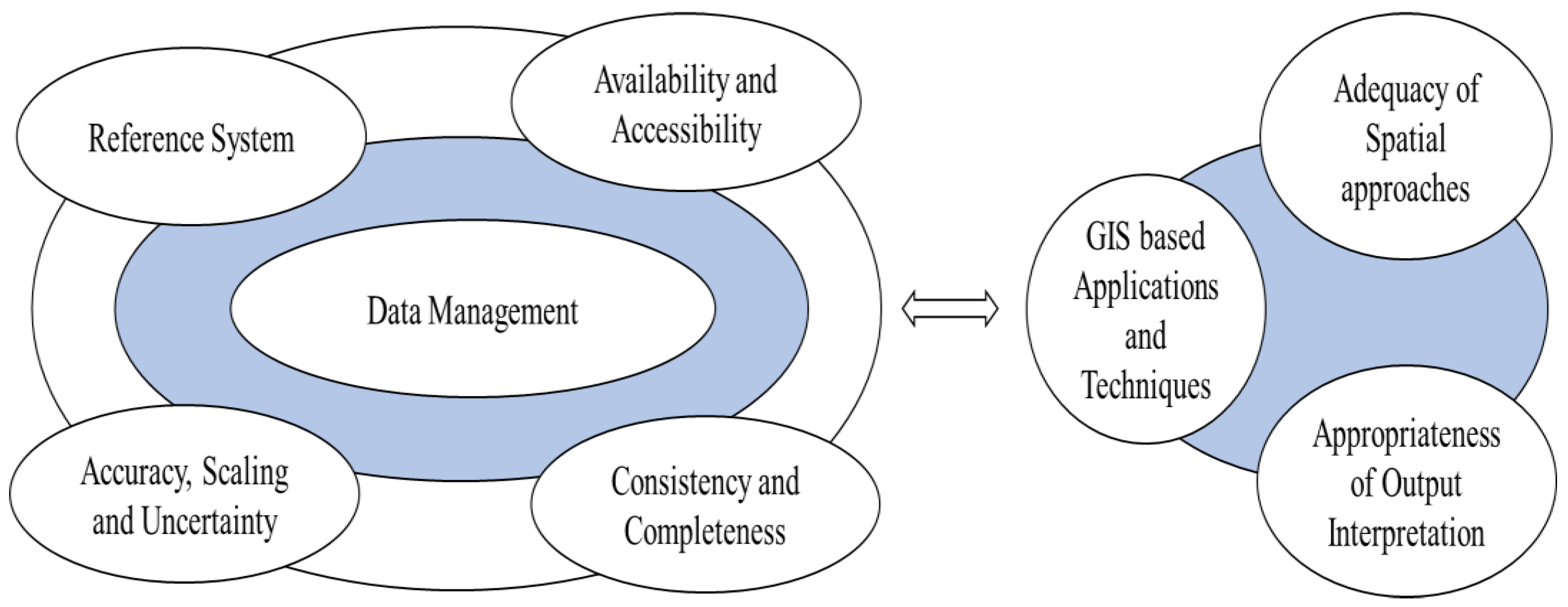
GIS can integrate the unique visualization effect and geographic analysis function of a map with general database operations (such as query and statistical analysis) to map and analyze the phenomena and events on the earth [3]. It is divided into five parts: personnel, data, hardware, software, and process [4]. The method of geological resource planning involves correctly and reasonably arranging and designing land resources within a certain range [5]. There are several considerations for effectual GIS resource planning and implementation which are described in Figure 1.
According to the scope controlled by geological resource planning, it can be divided into three types: national, regional, and enterprise units. On the basis of a comprehensive inventory of land resources, various types of land are classified and evaluated comprehensively. Then, according to the needs of national economic development, land use should be rationally organized, and land use scope and planning and design among industries, agriculture, water conservancy, culture, education, health, and other departments and enterprises should be allocated and determined [6]. Land is the most important natural resource. Rational planning and utilization of land and continuous improvement of its agricultural production level are of great significance to the realization of agricultural modernization and the development of national economies [7]. Environmental impact assessment, as a scientific method and technical means, refers to the analysis and demonstration of the possible environmental impacts caused by the proposed human activities. On this basis, the preventive measures and countermeasures are put forward [8]. The basic contents of environmental impact assessments include: the specific content of the construction plan, the environmental background of the construction site, the possible impact and damage to the environment after the completion and implementation of the project, the countermeasures to prevent these impacts and damage, and the economic and technological demonstration [9]. Environmental impact assessments have a preventive function before decision-making and development and construction activities begin. After the decision-making or the start of development and construction activities and through the implementation of environmental monitoring plans and sustainability studies, environmental impact assessments are still continuing, constantly verifying the evaluation conclusions and feeding back to decision makers and developers to further modify and improve their decision-making and development and construction activities [10].
The major motivation behind this research work is to assess the land resources and provide a conceptual framework for land evaluation. The GIS-based analysis of land suitability is done for assessing the land resources and evaluating the land related requirements for the identification of various domains which are strategically essential for certain activities. The data management perspective is also the evaluation criteria for GIS analysis and automation in the land evaluation domain.
This article assesses the impact of the geological resource planning and environmental assessments based on the geographic information system (GIS). This study considers the land resources of Yinan County in southeastern Shandong Province and is based on the GIS system implementation; the current situation of the land resource development is analyzed. The major research objectives of this work are:
- The development of a method for land resource planning and environmental impact mitigation measures;
- The analysis of the geological resource planning and environmental assessments through environmental impact;
- An indicator-based assessment of land resource planning based on the geographic information system.
The analysis revealed that the impact of the implementation of planning on most indicators is positive and beneficial, while the impact of negative indicators is relatively small. The implementation of the plan has little impact on most of the ecological environment indicators. It was revealed that construction and cultivated land development will improve the level of urbanization if the corresponding measures are taken to slow down or eliminate the negative development of ecological environment.
The remainder of this article is organized as follows. Section 2 depicts the survey of literature presenting the current state-of-the-art work done in this field. Section 3 details the complete methodology of the article followed by the results and discussion in Section 4. Concluding remarks are indicated in Section 5 of the research article.
2. Literature Review
There are several methodologies in the literature which employ various traditional approaches for assessing the quality of land suitability and analyze the environmental impact using GIS-based technologies.
Several technological approaches are based on Boolean algebra-based fuzzy approaches, weighted linear combination-based methods, and different regression-based techniques. Several methods are indicated in Table 1 showing the attempt of various researchers in the field of land suitability analysis.
Apart from these techniques, there are several other methods which assess the impact on the environment as well as risks involved in maintaining the quality of environment by environmental exposure to pollution, noise, gas emission, and various other economic activities [17,18].
A wide variety of methodologies and frameworks are available in the literature for performing environmental impact assessments and analyses. A holistic approach was considered by the authors in [19] which evaluates all the potential environmental factors generated by various activities involved in different organizations such as the mining industry, mineral processing, etc. [20,21,22]. The integrated approach was proposed by the researchers focusing on the design of mining and their sustainable development [23]. The various challenges were investigated by Salom and Kivinen [24] for the sustainable environmental image and development. An analytical approach was presented by Lyu [25] for minimizing the impact of environmental degradation and for optimizing the economic aspects of resource planning. Some of the mathematical matrix-based methods were presented by the authors in [26] for determining the environmental impact on various land resources.
There are several approaches that are being used for assessing the land suitability in terms of high, moderate, and low degree of utilization [27,28,29]. The quantitative assessment of numerical indicators has been done using mathematical modeling of various physical and geological conditions [30].
The land suitability is evaluated in a broader sense using the qualitative methods and various technical procedures [31,32]. Some of them are statistical, parametric, and arithmetic procedures, and the variations lie in their technical applicability [33,34]. The real-world challenges have been applicable to hybrid land evaluation systems, which further improve the accuracy, reliability, and suitability of various land resources [35]. There have been varying characteristics for land suitability evaluations, and the numerical values as well as the accountability of interactions expressed in terms of various indices is very important [36]. The index scores affect the overall suitability of the land evaluation method, and there may exist a bottleneck in terms of uncertainty and vagueness of the various determining factors.
The research has developed the geological resource planning and environmental impact in terms of application and methodological phases. There are several studies on land resource planning of low hills and gentle slopes, which cannot meet the needs of the low hilly and gentle slope land resources. Therefore, in this study, Yinan County in southeastern Shandong Province is taken as the research object, and its geological resource planning and environmental impact assessments are discussed on the basis of GIS technology, which provides a theoretical basis for geological resource planning on low hills and gentle slopes.
3. Materials and Methods
The raw field data involves geographical information providing insights on the spatial, temporal, and attributional reference framework. The raw data indicates the units of measurements, relevant data based on the time scale, and qualitative or quantifiable physical attributes associated with the land resource situation in Yinan County. The uniform dataset comprises consistent attributes and the type of dataset is GIS, which is collected from the current land resource situations of Yinan County. The raw data is collected from various physical geographical conditions, socio-economic conditions, and land resource development situations, which result in the analysis of land resource characteristics obtained using insights from the behavioral relationship and field observations supporting the environmental assessment. The relevant data was incorporated for the study, which is available from a reference system. The present research work uses the ArcGIS software package that has embedded inbuilt tools for enabling the transformation in the projection and data standardization. The data analysis is performed using the ArcGIS software package (https://www.esri.com/en-us/arcgis/products/arcgis-pro/overview) (accessed on 20 September 2021).
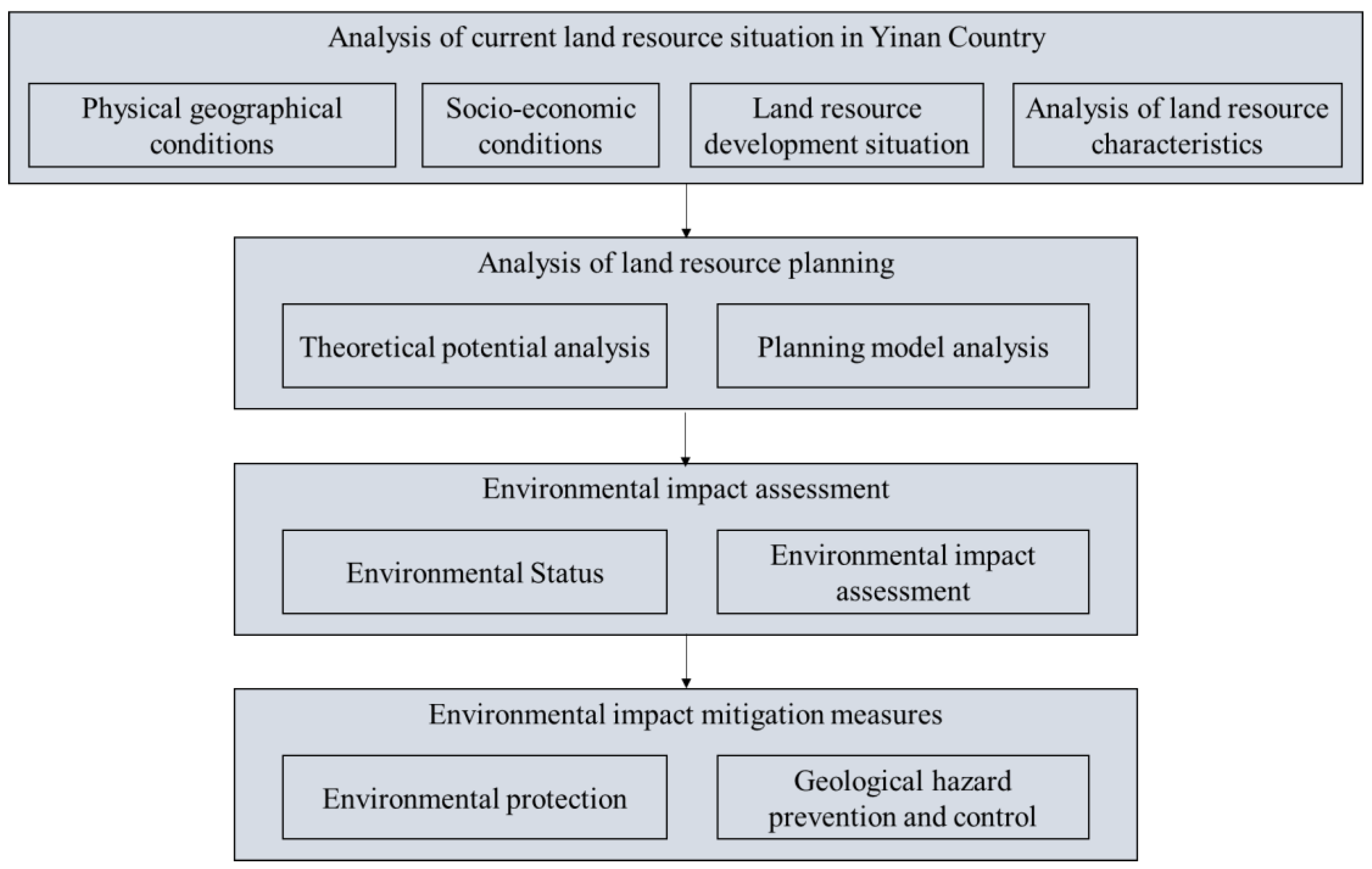
The entire methodology of this work has been divided into various steps, depicted in the flowchart shown in Figure 2, which is further detailed in the following subsections.
The land resources are initially analyzed for the physical geographical conditions of the study area, its socio-economic conditions, and the land resource development situation. The analysis of land resource characteristics is based on the data obtained from GIS. Furthermore, the analysis of land resource planning is based on the theoretical potential analysis and planning model. The environmental impact was assessed using various mitigation measures such as ecological, human settlement, and socio-economic indicators.
3.1. Current Situation of Land Resource Development in Yinan County
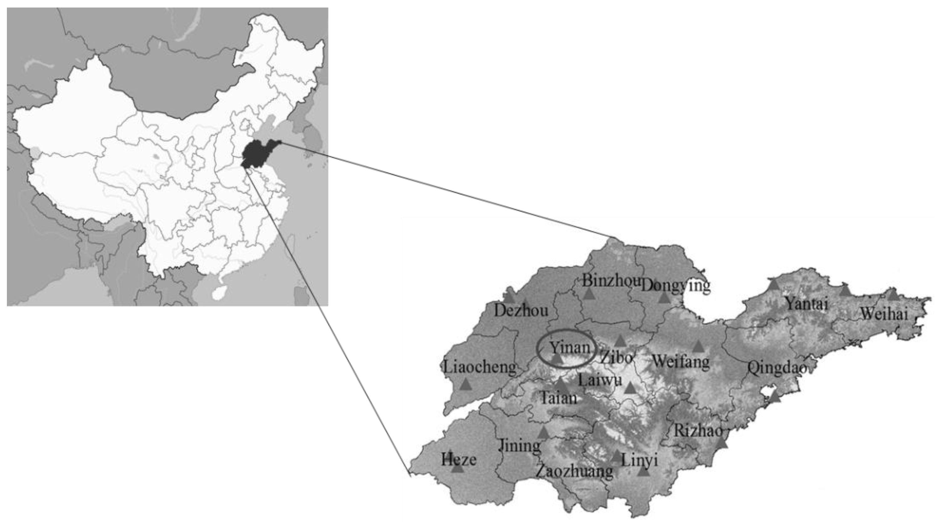
Physical geographic conditions: Yinan County is located in low mountain and hilly areas. Geomorphological zoning features are obvious. From west to east, the order is low mountain area, plain area, and hilly area. The altitude is between 88 and 762.8 m. There are more than 3400 hilltops, mostly in the western part of the county. Among them, there are 19 mountains 500 m above sea level. Its soil classification includes five soil types: brown loam, cinnamon soil, Chao soil, ginger black soil, and paddy soil. The physical geographical location of the study area map of Yinan county is depicted in Figure 3.
Socio-economic conditions: GDP per capita is US$3092. The proportion of the first, second, and third major industries is 19.4:47.8:32.8, respectively. The industrial economy has achieved rapid growth with the added value of all industries reaching 6.27 billion yuan, an average annual growth of 27.3%. The added value of the tertiary industry is 5.01 billion yuan, and its proportion has increased significantly.
Current situation of land resource development: The total land area of the county is 171,928.18 hm2, and the agricultural land area is 136,395.02 hm2, accounting for 79.33% of the total land area. The area of construction land is 2150.92 hm2, accounting for 12.52% of the total land area. The other land area is 14,002.24 hm2, accounting for 8.14% of the total land area. Through the spatial analysis of GIS, it is concluded that the resources of low hills and gentle slopes are about 82,579.17 hm2, accounting for 48.03% of the total land area of the county.
Analysis of land resource characteristics: The county’s low hill and gentle slope resources are relatively concentrated, and the total amount is relatively rich. The area with middle slopes less than 15 degrees accounts for 87.12%, which is suitable for comprehensive development and utilization. Natural reserved land accounts for 7.58% of the total area, which is relatively low. Due to the low proportion of natural reserves, the development and utilization of natural reserves should pay attention to further adjusting the rational use, focusing on tapping potential, combining with special planning, and carrying out rational development and utilization in a planned and step-by-step manner. The analysis output of land resources assessed on the basis of GIS are shown in Figure 4.
3.2. Analysis of Land Resource Planning
Theoretical potential analysis: The county’s land resource area is limited. Especially in recent years, with the rapid development of the social economy, with the enhancement of economic strength, and the improvement of the investment environment, the development of industrialization and urbanization has accelerated, and the demand for construction land has increased. According to the requirement of construction land for the balance of arable land occupation and compensation and the balance of arable land ownership, the current land reserve resources are insufficient. It is necessary to actively develop and utilize low hill and gentle slope resources, increase construction land, and supplement the source of arable land. Generally speaking, low hilly, gentle slopes with slopes ranging from 6 to 15 degrees are of high value for development and utilization. The area with better soil and water conditions can be basically cultivated land, and the part with high land quality of 15–25 degrees can be cultivated land. The rest of the gentle sloping land can be developed into economic forests and various types of forestry land. Blocks near residential areas with good traffic conditions are developed into construction land. Lower hills and gentle slopes are concentrated in the western part of the county, and there is a certain scale of concentrated distribution in Sun Zu Town, while other places show discrete distribution.
Planning model analysis: According to the requirements of local conditions and scientific development, the comprehensive development, improvement, and transformation of low hilly and gentle slope farmland reclamation are carried out through the main measures of land leveling, irrigation and drainage facilities, field roads, soil testing, and formula fertilization. In the construction land, it is necessary to strengthen environmental protection, implement soil and water conservation measures, rationally arrange the development schedule, and achieve ecological, safe, and orderly development. By sharing regional infrastructure, the land use structure within the block can be improved, the land development model can be optimized, and efficient, intensive, and rational utilization can be achieved.
3.3. Environmental Impact Assessment
Environmental status: There are more people and less land in the county. Moreover, the unreasonable exploitation and utilization of land, forest, water, and mineral resources for a long time have resulted in the lack of necessary protection and construction of the ecological environment and the increasingly stringent ecological environment. The main manifestations are soil erosion, vegetation destruction caused by unreasonable development and utilization, shrinkage of lakes, rivers, and wetlands, threats to biodiversity, and destruction of the ecological environment caused by the mining of mineral resources. In some places, ecological destruction and environmental pollution have become important factors restricting economic development, affecting social stability, and threatening people’s health.
Environmental impact assessment: The development of low hills and gentle slopes can solve the bottleneck problem of land shortage faced by the current agricultural development and urban construction to a large extent. However, the development of the hills, low hills, and gentle slopes project is the transformation and renewal of the original ecological environment, which will lead to the change of land use types, thus resulting in the change of ecosystem in the development area. In addition, many pollutants from modern construction equipment, machinery, industrial production activities, etc., will also bring adverse effects on the surrounding ecological system and environmental conditions.
3.4. Environmental Impact Mitigation Measures
Environmental protection: In the development of construction land, people should deal with the relationship between development and protection. In site leveling, people should strengthen the protection of existing water systems, reservoirs, and other water conservancy facilities, do a good job in flood control and waterlogging drainage projects, and pay attention to soil and water conservation. In block construction, people must strictly implement the “three simultaneous” system of soil and water conservation and environmental protection facilities construction, implement the requirements of discharge up to standard, and strengthen the inspection of water and soil conservation and the construction of the environmental protection facilities of the project. For development projects that fail to complete the relevant water and soil conservation and environmental protection facilities as required, they must be ordered to fulfill the requirements and protect the ecological environment in earnest. In the future, the industry guidance insists on the ecological environment as an important indicator, forbids pollution projects to occupy low hills and gentle slopes for construction, introduces low-consumption, light-pollution, and high-tech industries, and establishes a complete set of corresponding mechanisms to strengthen the supervision and management of enterprises entering the region. When cultivating cultivated land on low hills and gentle slopes, people should try their best to preserve the original ecological features, respect the production and living habits of farmers, and avoid the uniform modern pastoral style. In planning and design, many factors such as topography, landform, irrigation conditions and so on should be fully considered to design the direction of the field rationally. Terrace layout is used to reduce the amount of land leveling work. In the construction of the project, it is necessary to reduce the environmental impact of construction machinery and protect the surface organic tillage layer. In the development of construction land, it is necessary to implement the stripping project of tillage layer in the block as far as possible. The stripped organic tillage layer can be used to improve the quality of adjacent farmland as well as for the development projects of cultivated land so as to improve the quality of new cultivated land.
Geological hazard prevention and control: For the construction of sensitive areas with serious excavation, it is necessary to avoid the rainy season. Temporary rockfill and plastic film mulching should be used to prevent rainwater from scouring slopes and eroding the surface soil. For the cultivated land newly reclaimed on low hills and gentle slopes, suitable tillage methods are generally adopted, such as contour tillage and no tillage. Various water and soil conservation measures, such as building drainage ditches and reservoirs and other plant measures, are adopted to conserve the newly developed land. Making terraces as far as possible can not only keep water and soil, but also improve yield. In addition, the assessments of geological hazards should be strengthened to ensure the feasibility and safety of the geological resource planning.
4. Results
4.1. Result of Land Resource Planning and Distribution
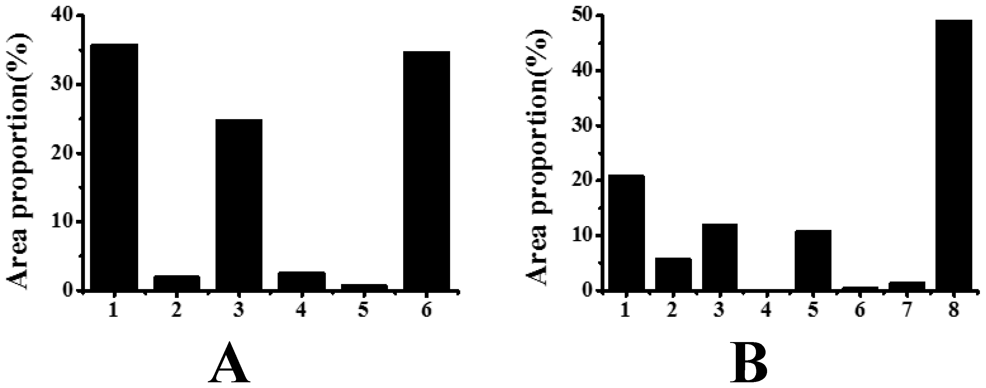
In the distribution of cultivated land, the development area is 1617.31 hm2. It is divided into two parts: land development reclamation and construction land reclamation, of which 577.32 hm2 is cultivated land, 30.43 hm2 is garden land, 399.66 hm2 is forest land, 40.87 hm2 is urban and rural construction land, 10.11 hm2 is traffic water conservancy and other construction land, and 558.92 hm2 is natural reserve land. In the layout of construction land, the development area is 841.94 hm2, of which 175.44 hm2 is cultivated land, 47.88 hm2 is garden land, 100.54 hm2 is forest land, 0.1 hm2 is other agricultural land, 90.45 hm2 is urban and rural construction land, 3.66 hm2 is traffic water conservancy and other construction land, 11.33 hm2 is water area, and 412.54 hm2 is natural reserve land. The land resource planning and distribution outcomes are shown in Figure 5.
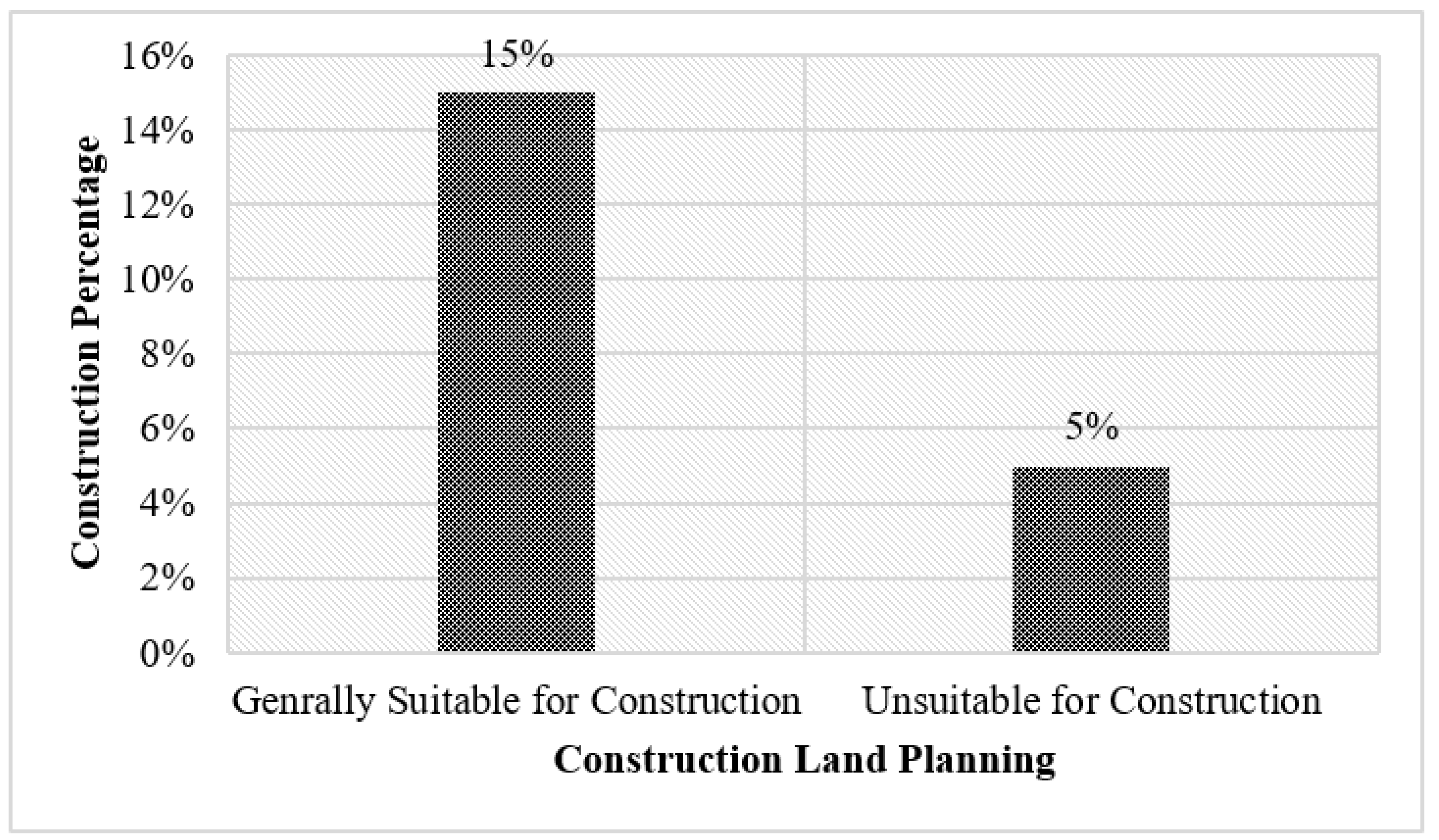
Similarly, the suitability of the construction land area is also identified out of the total planning area and is shown in Figure 6.
4.2. Results of Environmental Impact Assessment
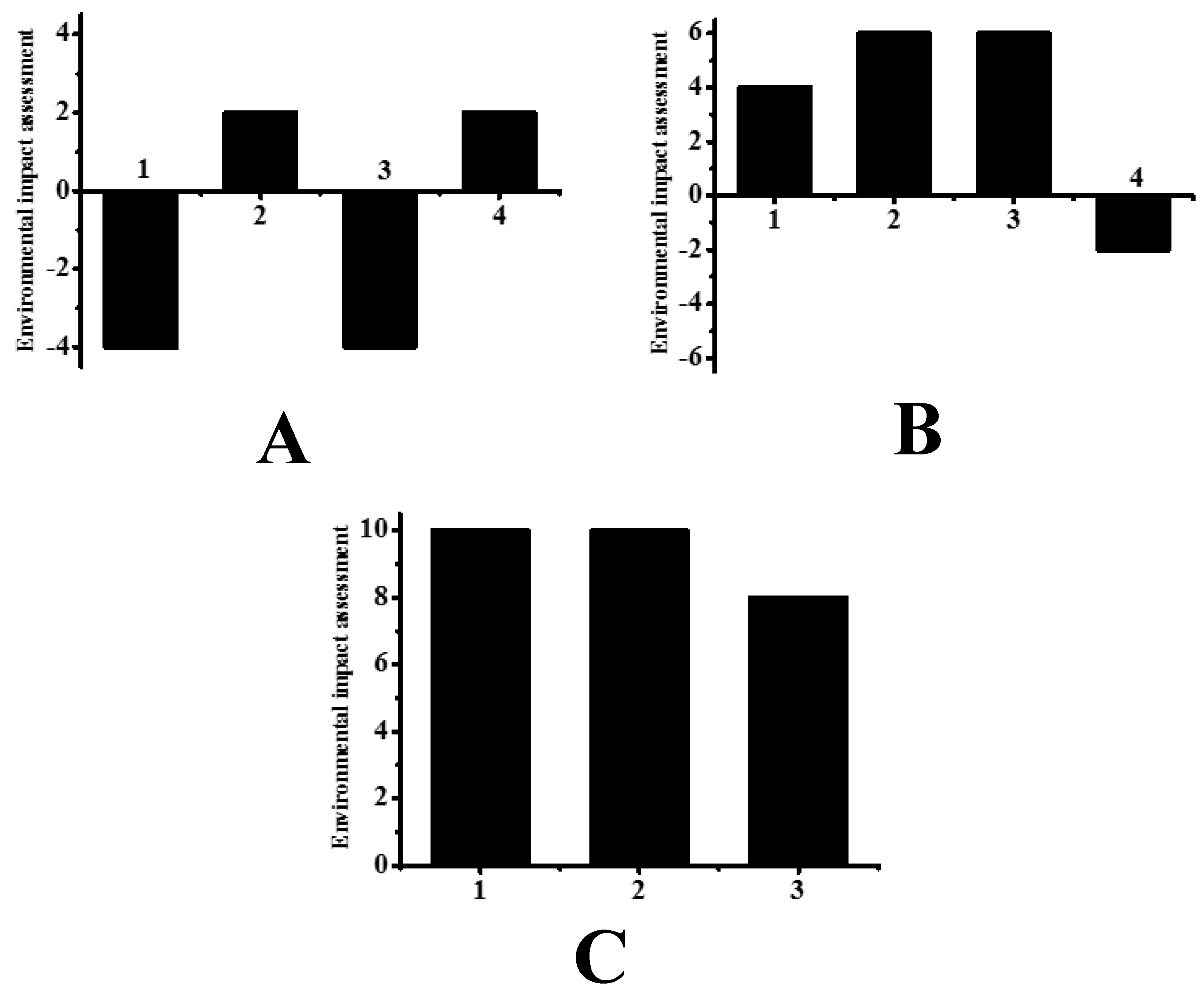
A hierarchical structure system with index level, criterion level, and target level is formed through three factors: ecological environment, human settlements environment, and socio-economic environment. Classification and grading are given, as shown in Table 2 and Figure 7.
It can be seen that most of the indicators are positive and beneficial, while the negative indicators have relatively small impacts.
5. Discussion
The results obtained from the land resource planning and distribution provide the description of cultivated land area which can be further divided into land development reclamation as well as construction land. Further, the subdivision is provided in terms of garden land, cultivation land, forest land as well as urban and rural land. The land is further sub-divided in terms of lands to be utilized as natural reserve land, construction land, traffic water conservancy, and various other construction lands. The results are depicted in terms of land resource planning and distribution as per the percentage of land suitable for construction and unsuitability of land resources. This research work also assesses the environmental impact of land resource planning and its assessment. A hierarchal structure is presented along with various index levels, criterion levels, and target levels. The criteria levels were sub-divided into ecological environment, human settlement environment as well as socio-economic environment. The index levels are provided in terms of ecological environmental factors such as development of new cultivated land in unused land suitable for cultivation, reclamation scale of construction land, development of suitable forest land, and new construction land. The human settlement environment is depicted in terms of development of new forest land, per capita urban construction land area, and proportion of construction land to regional area. The socio-economic environment is provided as per-capita net income, per capita GDP, and urbanization level. The environmental impact assessment indicators are provided ranging from −10 to 10.
The effectiveness of the environmental analysis providing insights on spatial and temporal attributes requires a thorough understanding of the factors that determine the validity of the assessment. The GIS analysis ensures the accountability of output assessments which use the optimal data availability for obtaining reliable outcomes. The various assessment stages involve different modelling methods, and the assessment parameters are analyzed through various flexible GIS-based land resource planning stages. The efficacy and performance assessment of different assessment stages are conducted in terms of environmental reports and evaluation of environmental impact factors. However, further development of the potential performance can be performed using the comprehensive approach. The future of GIS-based research can be improved through public participation and by enhancing the research-oriented applications. Further, the precise output interpretation and evaluation should involve better planning and environmental management by utilizing the impact assessment process.
6. Conclusions
In this study, geological resource planning and environmental impact assessments based on GIS are studied. The land resources of Yinan County in southeastern Shandong Province are taken as the research object. Based on GIS, the current situation of land resource development is analyzed, land resource planning is carried out, and environmental impact mitigation measures are evaluated and analyzed through environmental impact. In the distribution of cultivated land, the development area is 1617.31 hm2, of which 577.32 hm2 is cultivated land, 30.43 hm2 is garden land, 399.66 hm2 is forest land, 40.87 hm2 is urban and rural construction land, 10.11 hm2 is traffic water conservancy and other construction land, and 558.92 hm2 is natural reserve land. In the layout of construction land, the development area is 841.94 hm2, of which 175.44 hm2 is cultivated land, 47.88 hm2 is garden land, 100.54 hm2 is forest land, 0.1 hm2 is other agricultural land, 90.45 hm2 is urban and rural construction land, 3.66 hm2 is traffic water conservancy and other construction land, 11.33 hm2 is water area, and 412.54 hm2 is natural reserve land. The impact of the implementation of planning on most indicators is positive and beneficial, while the impact of negative indicators is relatively small. Generally speaking, the implementation of the plan has little impact on most of the ecological environment indicators. Construction and cultivated land development will improve the level of urbanization. In the process of planning implementation, corresponding measures should be taken to slow down or eliminate the negative development of the ecological environment.
Therefore, in this study, geological resource planning and environmental impact assessments based on GIS are studied. Generally speaking, the implementation of the plan has less impact on most of the indicators of the ecological environment. In this study, although a qualitative environmental impact assessment has been carried out, it is difficult to quantitatively assess the impact of the development process on the ecological environment. The mitigation measures mentioned in the study are also inadequate and need further study.
Author Contributions
Y.X. conceived and performed the research; B.X. wrote the paper; Z.W. and R.K.G. analyzed the data; M.A.A. and M.M. provided funding support and guidance; M.B. wrote and revised the paper. All authors have read and agreed to the published version of the manuscript.
Funding
This research was funded by Taif University researchers supporting project number (TURSP-98), Taif University, Taif, Saudi Arabia.
Institutional Review Board Statement
Not Applicable.
Informed Consent Statement
Not Applicable.
Data Availability Statement
All data alreay shared in the manuscript.
Acknowledgments
Authors would like to thank Taif University researchers supporting project.
Conflicts of Interest
The authors declare no conflict of interest.
References
- Matin, M.A.; Chitale, V.S.; Murthy, M.S.R.; Uddin, K.; Bajracharya, B.; Pradhan, S. Understanding forest fire patterns and risk in Nepal using remote sensing, geographic information system and historical fire data. Int. J. Wildland Fire 2017, 26, 276–286. [Google Scholar] [CrossRef] [Green Version]
- Risky, Y.S.; Wahyu, N.; Ramadhani, Y.A.R.; Brada, I.T.; Artanti, P.Z.; Rosyita, A.; Wisudawan, P.D. Using Remote Sensing and Geographic Information System (GIS) for Peak Discharge Estimating in Catchment of Way Ratai, Pesawaran District, Lampung Province. IOP Conf. Ser. Earth Environ. Sci. 2018, 165, 012032. [Google Scholar] [CrossRef]
- Pakzad, R.; Dabbagh-Moghaddam, A.; Mohebali, M.; Safiri, S.; Barati, M. Spatio-temporal analysis of cutaneous leishmaniasis using geographic information system among Iranian Army Units and its comparison with the general population of Iran during 2005–2014. J. Parasit. Dis. 2017, 41, 1114–1122. [Google Scholar] [CrossRef]
- Garcia, A.G.; Araujo, M.R.; Uramoto, K.; Walder, J.M.M.; Zucchi, R.A. Geostatistics and Geographic Information System to Analyze the Spatial Distribution of the Diversity of Anastrepha Species (Diptera: Tephritidae): The Effect of Forest Fragments in an Urban Area. Environ. Èntomol. 2017, 46, 1189–1194. [Google Scholar] [CrossRef] [PubMed]
- Anis, M.; Idrus, A.; Amijaya, H.; Subagyo. GIS-Based Optimization Method for Utilizing Coal Remaining Resources and Post-Mining Land Use Planning: A Case Study of PT Adaro Coal Mine in South Kalimantan. Adv. Sci. Lett. 2017, 23, 2231–2235. [Google Scholar] [CrossRef]
- Dongling, Z.; Shanshan, H.; Jianyu, Y. Qualitative Potential Calculation of Arable Land Consolidation Based on Limiting Factors and Hot Spot Analysis. Trans. Chin. Soc. Agric. Mach. 2017, 48, 158–164. [Google Scholar]
- Duarte, F.; Doherty, G.; Nakazawa, P. Redrawing the boundaries: Planning and governance of a marine protected area—The case of the Exuma Cays Land and Sea Park. J. Coast. Conserv. 2017, 21, 265–271. [Google Scholar] [CrossRef] [Green Version]
- Olagunju, E.; Ariyibi, E.; Awoyemi, M.; Adebayo, A.; Dasho, O.; Adenika, C. Application of geochemical and geophysical approach to environmental impact assessment: A case study of Emirin active open dumpsite, Ado-Ekiti Southwestern Nigeria. Model. Earth Syst. Environ. 2017, 3, 1545–1555. [Google Scholar] [CrossRef]
- Singh, N.K.; Singh, R.P.; Kazmi, A.A. Environmental impact assessment of a package type IFAS reactor during construction and operational phases: A life cycle approach. Water Sci. Technol. A J. Int. Assoc. Water Pollut. Res. 2017, 75, 2246–2256. [Google Scholar] [CrossRef] [PubMed] [Green Version]
- Moyo, B.; Dirsuweit, T.; Cameron, A. The limits of public participation in environmental impact assessment processes: The case of indigenous communities in Mapela, Limpopo Province. Transform. Crit. Perspect. S. Afr. 2017, 94, 28–50. [Google Scholar] [CrossRef]
- Bagherzadeh, A.; Gholizadeh, A. Modeling land suitability evaluation for wheat production by parametric and TOPSIS approaches using GIS, northeast of Iran. Model. Earth Syst. Environ. 2016, 2, 126. [Google Scholar] [CrossRef] [Green Version]
- Bagherzadeh, A.; Ghadiri, E.; Darban, A.R.S.; Gholizadeh, A. Land suitability modeling by parametric-based neural networks and fuzzy methods for soybean production in a semi-arid region. Model. Earth Syst. Environ. 2016, 2, 104. [Google Scholar] [CrossRef] [Green Version]
- Danvi, A.; Jütten, T.; Giertz, S.; Zwart, S.; Diekkrüger, B. A spatially explicit approach to assess the suitability for rice cultivation in an inland valley in central Benin. Agric. Water Manag. 2016, 177, 95–106. [Google Scholar] [CrossRef]
- López-Blanco, J.; Pérez-Damián, J.L.; Conde-Álvarez, A.C.; Gómez-Díaz, J.D.; Monterroso-Rivas, A.I. Land suitability levels for rainfed maize under current conditions and climate change projections in Mexico. Outlook Agric. 2018, 47, 181–191. [Google Scholar] [CrossRef]
- Raza, S.M.H.; Mahmood, S.A.; Khan, A.A.; Liesenberg, V. Delineation of Potential Sites for Rice Cultivation Through Multi-Criteria Evaluation (MCE) Using Remote Sensing and GIS. Int. J. Plant Prod. 2018, 12, 1–11. [Google Scholar] [CrossRef] [Green Version]
- Bhermana, A.; Syamsuddin; Suparman; Agustini, S.; Susilawati; Irwandi, D.; Firmansyah, M.A. Spatial landuse planning for developing sustainable food crop areas using land evaluation approach and GIS application (a case study of Pulang Pisau Regency, Central Kalimantan). IOP Conf. Ser. Earth Environ. Sci. 2021, 648, 012011. [Google Scholar] [CrossRef]
- Hassan, I.; Javed, M.A.; Asif, M.; Luqman, M.; Ahmad, S.R.; Ahmad, A.; Akhtar, S.; Hussain, B. Weighted overlay based land suitability analysis of agriculture land in Azad Jammu and Kashmir using GIS and AHP. Pak. J. Agric. Sci. 2020, 57, 1509–1519. [Google Scholar]
- Leroux, L.; Castets, M.; Baron, C.; Escorihuela, M.-J.; Bégué, A.; Seen, D.L. Maize yield estimation in West Africa from crop process-induced combinations of multi-domain remote sensing indices. Eur. J. Agron. 2019, 108, 11–26. [Google Scholar] [CrossRef]
- Lo-Iacono-Ferreira, V.G.; Torregrosa-López, J.I.; Capuz-Rizo, S.F. Organizational life cycle assessment: Suitability for higher education institutions with environmental management systems. Int. J. Life Cycle Assess. 2017, 22, 1928–1943. [Google Scholar] [CrossRef]
- Chen, W.; Geng, Y.; Hong, J.; Dong, H.; Cui, X.; Sun, M.; Zhang, Q. Life cycle assessment of gold production in China. J. Clean. Prod. 2018, 179, 143–150. [Google Scholar] [CrossRef]
- Yao, K.A.F.; Yao, B.K.; Belcourt, O.; Salze, D.; Lasm, T.; Lopez-Ferber, M.; Junqua, G. Mining Impacts Assessment Using the LCA Methodology: Case Study of Afema Gold Mine in Ivory Coast. Integr. Environ. Assess. Manag. 2021, 17, 465–479. [Google Scholar] [CrossRef]
- Rahimi, E.; Ghasemzadeh, H. A new algorithm to determine optimum cut-off grades considering technical, economical, environmental and social aspects. Resour. Policy 2015, 46, 51–63. [Google Scholar] [CrossRef]
- Pactwa, K.; Woźniak, J.; Strempski, A. Sustainable mining—Challenge of Polish mines. Resour. Policy 2018, 74, 101269. [Google Scholar] [CrossRef]
- Salom, A.T.; Kivinen, S. Closed and abandoned mines in Namibia: A critical review of environmental impacts and constraints to rehabilitation. S. Afr. Geogr. J. 2019, 102, 389–405. [Google Scholar] [CrossRef]
- Lyu, Z.; Chai, J.; Xu, Z.; Qin, Y. Environmental Impact Assessment of Mining Activities on Groundwater: Case Study of Copper Mine in Jiangxi Province, China. J. Hydrol. Eng. 2019, 24, 05018027. [Google Scholar] [CrossRef]
- Zarubin, M.; Statsenko, L.; Spiridonov, P.; Zarubina, V.; Melkoumian, N.; Salykova, O. A GIS Software Module for Environmental Impact Assessment of the Open Pit Mining Projects for Small Mining Operators in Kazakhstan. Sustainability 2021, 13, 6971. [Google Scholar] [CrossRef]
- Bodaghabadi, M.B.; Martinez-Casasnovas, J.A.; Khakili, P.; Masihabadi, M.H.; Gandomkar, A. Assessment of the FAO traditional land evaluation methods, A case study: Iranian Land Classification method. Soil Use Manag. 2015, 31, 384–396. [Google Scholar] [CrossRef] [Green Version]
- Demirtas, H.; Nordgren, R. Introduction to Scientific Programming and Simulation Using R (2nd Edition). J. Stat. Softw. 2017, 78, 1–4. [Google Scholar] [CrossRef] [Green Version]
- Ebrahim, F. A Land Suitability Evaluation for Improved Subsistence Agriculture Using GIS: The Case Study of Nkwezela, Kwazulu-Natal, South Africa. Master’s Thesis, University of KwaZulu-Natal, Pietermaritzburg, South Africa, 2007. [Google Scholar]
- Kaim, A.; Cord, A.; Volk, M. A review of multi-criteria optimization techniques for agricultural land use allocation. Environ. Model. Softw. 2018, 105, 79–93. [Google Scholar] [CrossRef]
- Mendoza, G.; Martins, H. Multi-criteria decision analysis in natural resource management: A critical review of methods and new modelling paradigms. For. Ecol. Manag. 2006, 230, 1–22. [Google Scholar] [CrossRef]
- Ghansah, B.; Forkuo, E.K.; Osei, E.F.; Appoh, R.K.; Asare, M.Y.; Kluste, N.A.B. Mapping the spatial distribution of small reservoirs in the White Volta Sub-basin of Ghana. Remote. Sens. Appl. Soc. Environ. 2018, 9, 107–115. [Google Scholar] [CrossRef]
- Gibbs, H.K.; Salmon, J.M. Mapping the world’s degraded lands. Appl. Geogr. 2015, 57, 12–21. [Google Scholar] [CrossRef]
- Hoseini, Y.; Kamrani, M. Using a fuzzy logic decision system to optimize the land suitability evaluation for a sprinkler irrigation method. Outlook Agric. 2018, 47, 298–307. [Google Scholar] [CrossRef]
- El Baroudy, A. Mapping and evaluating land suitability using a GIS-based model. Catena 2016, 140, 96–104. [Google Scholar] [CrossRef]
- Silva-Gallegos, J.J.; Aguirre-Salado, C.A.; Miranda-Aragón, L.; Sánchez-Díaz, G.; Valdez-Lazalde, J.R.; Pedroza-Carneiro, J.W.; Flores-Cano, J.A. Locating Potential Zones for Cultivating Stevia rebaudiana in Mexico: Weighted Linear Combination Approach. Sugar Tech. 2017, 19, 206–218. [Google Scholar] [CrossRef]
Figure 1.
Consideration for effectual GIS resource planning and implementation.

Figure 2.
Flowchart of geological resource planning and environmental impact assessment methodology.
Figure 2.
Flowchart of geological resource planning and environmental impact assessment methodology.

Figure 3.
Physical geographical location of study area map of Yinan County.

Figure 4.
GIS-based land resource map of Yinan County.

Figure 5.
Results of land resource planning and distribution ((A): cultivated land distribution results; 1: cultivated land, 2: garden land, 3: forest land, 4: urban and rural construction land, 5: traffic water conservancy and other construction land, 6: natural reserve land; (B): construction land distribution results; 1: cultivated land, 2: garden land, 3: forest land, 4: other agricultural land, 5: urban and rural construction land, 6: traffic water conservancy and other construction land, 7: waters, 8: natural reserve).

Figure 6.
Suitability of construction land area is also identified out of the total planning area.

Figure 7.
Results of environmental impact assessment ((A): ecological environment; (B): human settlement environment; (C): socio-economic environment).
Figure 7.
Results of environmental impact assessment ((A): ecological environment; (B): human settlement environment; (C): socio-economic environment).


Table 1.
Different state-of-the-art methods for the analysis of land suitability.
| Authors | Methods Employed for Analysis |
|---|---|
| Bagherzadeh and Gholizadeh [11] | Artificial neural network (ANN) |
| Bagherzadeh et al. [12] | Fuzzy approach |
| Danvi et al. [13] | Machine learning (ML) |
| Lopez-Blanco et al. [14] | Fuzzy-based method + ML |
| Raza et al. [15] | Fuzzy-based method |
| Bhermama et al. [16] | GIS+ land suitability evaluation (LSE) |
Table 2.
Results of environmental impact assessment.
| Criterion Level | Index Level | Environmental Impact Assessment |
|---|---|---|
| Ecological environment | Development of new cultivated land in unused land suitable for cultivation | −4 |
| Reclamation scale of construction land | 2 | |
| Development of suitable forest land | −4 | |
| New construction land | 2 | |
| Human settlement environment | Unit construction land | 4 |
| Development of new forest land | 6 | |
| Per capita urban construction land area | 6 | |
| Proportion of construction land to regional area | −2 | |
| Socio-economic environment | Per capita net income | 10 |
| Per capita GDP | 10 | |
| Urbanization level | 8 |
Publisher’s Note: MDPI stays neutral with regard to jurisdictional claims in published maps and institutional affiliations. |
© 2022 by the authors. Licensee MDPI, Basel, Switzerland. This article is an open access article distributed under the terms and conditions of the Creative Commons Attribution (CC BY) license (https://creativecommons.org/licenses/by/4.0/).
Share and Cite
MDPI and ACS Style
Xie, Y.; Xie, B.; Wang, Z.; Gupta, R.K.; Baz, M.; AlZain, M.A.; Masud, M. Geological Resource Planning and Environmental Impact Assessments Based on GIS. Sustainability 2022, 14, 906. https://0-doi-org.brum.beds.ac.uk/10.3390/su14020906
AMA Style
Xie Y, Xie B, Wang Z, Gupta RK, Baz M, AlZain MA, Masud M. Geological Resource Planning and Environmental Impact Assessments Based on GIS. Sustainability. 2022; 14(2):906. https://0-doi-org.brum.beds.ac.uk/10.3390/su14020906
Chicago/Turabian StyleXie, Yun, Binggeng Xie, Ziwei Wang, Rajeev Kumar Gupta, Mohammed Baz, Mohammed A. AlZain, and Mehedi Masud. 2022. "Geological Resource Planning and Environmental Impact Assessments Based on GIS" Sustainability 14, no. 2: 906. https://0-doi-org.brum.beds.ac.uk/10.3390/su14020906
Note that from the first issue of 2016, this journal uses article numbers instead of page numbers. See further details here.