
Tsunami Hazard Zone and Multiple Scenarios of Tsunami Evacuation Route at Jetis Beach, Cilacap Regency, Indonesia

 ,
, 
Abstract
:1. Introduction
1.1. Study Background
1.2. Significance of the Research Location, Purpose, and Contribution of This Study
2. Literature Review
2.1. Geo-Tectonic Setting
2.2. Tsunami Wave and Evacuation Route Simulation
3. Materials and Methods
4. Results
5. Discussion
6. Conclusions
Author Contributions
Funding
Institutional Review Board Statement
Informed Consent Statement
Data Availability Statement
Conflicts of Interest
Appendix A


References
- Faiqoh, I.; Gaol, J.L.; Ling, M.M. Vulnerability level map of tsunami disaster in Pangandaran Beach, West Java. Int. J. Remote Sens. Earth Sci. 2014, 10, 90–103. [Google Scholar] [CrossRef] [Green Version]
- Widiyantoro, S.; Gunawan, E.; Muhari, A.; Rawlinson, N.; Mori, J.; Hanifa, N.R.; Susilo, S.; Supendi, P.; Shiddiqi, H.A.; Nugraha, A.D.; et al. Implications for megathrust earthquakes and tsunamis from seismic gaps south of Java Indonesia. Sci. Rep. 2020, 1, 15274. [Google Scholar] [CrossRef] [PubMed]
- BMKG. Katalog Gempabumi Signifikan Dan Merusak 1821–2017, 1st ed.; Badan Meteorologi Klimatologi dan Geofisika: Jakarta, Indonesia, 2018; pp. 1–252. [Google Scholar]
- Usman, F.; Murakami, K.; Hariyani, S.; Kurniawan, E.B.; Shoimah, F. Tsunami disaster mitigation analysis on the shore of Java Island using CADMAS/Surf numerical simulations. Disaster Adv. 2019, 12, 1–5. [Google Scholar]
- Windupranata, W.; Hanifa, N.R.; Nusantara, C.A.D.S.; Aristawati, G.; Arifianto, M.R. Analysis of tsunami hazard in the Southern Coast of West Java Province-Indonesia. IOP Conf. Ser. Earth Environ. Sci. 2020, 618, 012026. [Google Scholar] [CrossRef]
- Kato, T.; Ito, T.; Abidin, H.Z.; Agustan. Preliminary report on crustal deformation surveys and tsunami measurements caused by the July 17, 2006 South off Java Island earthquake and tsunami, Indonesia. Earth Planets Space 2007, 59, 1055–1059. [Google Scholar] [CrossRef] [Green Version]
- Salmanidou, D.M.; Ehara, A.; Himaz, R.; Heidarzadeh, M.; Guillas, S. Impact of future tsunamis from the Java trench on household welfare: Merging geophysics and economics through catastrophe modelling. Int. J. Disaster Risk Reduct. 2021, 61, 102291. [Google Scholar] [CrossRef]
- Laksono, F.A.T.; Aditama, M.R.; Setijadi, R.; Ramadhan, G. Run-up height and flow depth simulation of the 2006 South Java tsunami using COMCOT on Widarapayung Beach. IOP Conf. Ser. Mater. Sci. Eng. 2020, 982, 012047. [Google Scholar] [CrossRef]
- Gunawan, E.; Widiyantoro, S. Active tectonic deformation in Java, Indonesia inferred from a GPS-derived strain rate. J. Geodyn. 2019, 123, 49–54. [Google Scholar] [CrossRef]
- Pribadi, K.S.; Abduh, M.; Wirahadikusumah, R.D.; Hanifa, N.R.; Irsyam, M.; Kusumaningrum, P.; Puri, E. Learning from past earthquake disasters: The need for knowledge management system to enhance infrastructure resilience in Indonesia. Int. J. Disaster Risk Reduct. 2021, 64, 102424. [Google Scholar] [CrossRef]
- Asri, A.K.; Elya, H.; Duantari, N.; Suryaningsih, E.; Victoria, L.D.D.D. Dual Mitigation System: Database System Combination of EWS and APRS for Disaster Management (Case Study: Malang Southern Coast). Procedia-Soc. Behav. Sci. 2016, 227, 435–441. [Google Scholar] [CrossRef] [Green Version]
- Nusantara, D.S.C.A.; Windupranata, W.; Hayatiningsih, I.; Hanifa, N.R. Mapping of IOC-UNESCO tsunami ready indicators in the Pangandaran Village, Indonesia. IOP Conf. Ser. Earth Environ. Sci. 2021, 925, 012041. [Google Scholar] [CrossRef]
- Tappin, D.R. Submarine landslides and their tsunami hazard. Annu. Rev. Earth. Planet Sci. 2021, 49, 551–578. [Google Scholar] [CrossRef]
- Siagian, T.H.; Purhadi, P.; Suhartono, S.; Ritonga, H. Social vulnerability to natural hazards in Indonesia: Driving factors and policy implications. Nat. Hazards 2014, 70, 1603–1617. [Google Scholar] [CrossRef]
- Adriano, B.; Xia, J.; Baier, G.; Yokoya, N.; Koshimura, S. Multi-source data fusion based on ensemble learning for rapid building damage mapping during the 2018 Sulawesi earthquake and Tsunami in Palu, Indonesia. Remote Sens. 2019, 11, 886. [Google Scholar] [CrossRef] [Green Version]
- Dewatama, E. Tsunami hazard mapping and loss estimation in Yogyakarta International Airport Area. Built Environ. Stud. 2021, 2, 1–11. [Google Scholar] [CrossRef]
- Khomarudin, M.R.; Günter, S.; Ralf, L.; Kai, Z.; Joachim, P.; Widjo, K.; Widodo, P.S. Hazard analysis and estimation of people exposure as contribution to tsunami risk assessment in the west coast of sumatra, the south coast of Java and Bali. Z. Fur Geomorphol. 2010, 54, 337–356. [Google Scholar] [CrossRef]
- Anwar, K.; Muskananfola, M.R.; Helmi, M. Spatial analysis of tsunami threat level in the coastal of Jember Regency, East Java, Indonesia. Asian J. Microbiol. Biotechnol. Environ. Sci. 2018, 20, 1153–1162. [Google Scholar]
- Suppasri, A.; Muhari, A.; Syamsidik; Yunus, R.; Pakoksung, K.; Imamura, F.; Koshimura, S.; Paulik, R. Vulnerability characteristics of tsunamis in Indonesia: Analysis of the global centre for disaster statistics database. J. Disaster Res. 2018, 13, 1039–1048. [Google Scholar] [CrossRef]
- Cahyaning, S.I.; Fadly, U.; Keisuke, M.; Suluh, W.I.N. Geographic information system and weighting technique for tsunami risk assessment in coastal villages of Jember Regency, Indonesia. Disaster Adv. 2021, 14, 38–50. [Google Scholar]
- Horspool, N.; Pranantyo, I.; Griffin, J.; Latief, H.; Natawidjaja, D.H.; Kongko, W.; Cipta, A.; Bustaman, B.; Anugrah, S.D.; Thio, H.K. A probabilistic tsunami hazard assessment for Indonesia. Nat. Hazards Earth Syst. Sci. 2014, 14, 3105–3122. [Google Scholar] [CrossRef] [Green Version]
- Hall, S.; Pettersson, J.; Meservy, W.; Harris, R.; Agustinawati, D.; Olson, J.; McFarlane, A. Awareness of tsunami natural warning signs and intended evacuation behaviors in Java, Indonesia. Nat. Hazards. 2017, 89, 473–496. [Google Scholar] [CrossRef]
- BPS Cilacap. Kabupaten Cilacap Dalam Angka 2017, 1st ed.; Badan Pusat Statistik Kabupaten Cilacap: Cilacap, Indonesia, 2018; pp. 1–299. [Google Scholar]
- Siregar, A.S.; Romdoni, T.A.; Prayogo, N.A. Water quality monitoring using WQI method in Cemara Sewu shrimp farm Jetis Cilacap Regency. IOP Conf. Ser. Earth Environ. Sci. 2019, 255, 012038. [Google Scholar] [CrossRef]
- Lestiani, D.D.; Santoso, M.; Kurniawati, S.; Adventini, N.; Prakoso, D.A.D. Characteristics of feed coal and particulate matter in the vicinity of coal-fired power plant in Cilacap, Central Java, Indonesia. Procedia Chem. 2015, 16, 216–221. [Google Scholar] [CrossRef] [Green Version]
- Kasikoen, K.M. Urbanization and change in Cilacap Regency. Procedia-Soc. Behav. Sci. 2016, 227, 70–74. [Google Scholar] [CrossRef] [Green Version]
- Yudhicara, Y.; Zaim, Y.; Rizal, Y.; Aswan, A.; Triyono, R.; Setiyono, U.; Hartanto, D. Characteristics of paleotsunami sediments, a case study in Cilacap and Pangandaran coastal areas, Jawa, Indonesia. Indones. J. Geosci. 2013, 8, 163–175. [Google Scholar] [CrossRef]
- Gunawan, E.; Meilano, I.; Abidin, H.Z.; Hanifa, N.R.; Susilo. Analysis of coseismic fault slip models of the 2012 Indian ocean earthquake: Importance of GPS data for crustal deformation studies. Acta Geophys. 2016, 117, 64–72. [Google Scholar] [CrossRef] [Green Version]
- Koulali, A.; McClusky, S.; Susilo, S.; Leonard, Y.; Cummins, P.; Tregoning, P.; Meilano, I.; Efendi, J.; Wijanarto, A.B. The kinematics of crustal deformation in Java from GPS observations: Implications for fault slip partitioning. Earth Planet. Sci. Lett. 2017, 458, 69–79. [Google Scholar] [CrossRef]
- Rosalia, S.; Widiyantoro, S.; Nugraha, A.D.; Supendi, P. Double-difference tomography of p-and s-wave velocity structure beneath the western part of Java, Indonesia. Earthq. Sci. 2019, 32, 12–25. [Google Scholar] [CrossRef]
- Silpa, K.; Earnest, A. A note on stress rotations due to the 2004 Mw 9.2 Sumatra-Andaman megathrust earthquake. J. Earth Syst. Sci. 2020, 129, 187. [Google Scholar] [CrossRef]
- Supendi, P.; Nugraha, A.D.; Puspito, N.T.; Widiyantoro, S.; Daryono, D. Identification of active faults in West Java, Indonesia, based on earthquake hypocenter determination, relocation, and focal mechanism analysis. Geosci. Lett. 2018, 5, 31. [Google Scholar] [CrossRef]
- Daryono, M.R.; Natawidjaja, D.H.; Sapiie, B.; Cummins, P. Earthquake geology of the Lembang Fault, West Java, Indonesia. Tectonophysics 2019, 751, 180–191. [Google Scholar] [CrossRef]
- USGS. 20 Largest Earthquakes in the World, 1st ed.; United States Geological Survey: Reston, VA, USA, 2020; pp. 1–15. [Google Scholar]
- Pasari, S.; Simanjuntak, A.V.H.; Mehta, A.; Neha; Sharma, Y. The current state of earthquake potential on Java Island, Indonesia. Pure Appl. Geophys. 2021, 178, 2789–2806. [Google Scholar] [CrossRef]
- Sutrisna, M.; Sulaeman, C.; Ardi, N.D. Microtremor Methode for Microzonation in Cilacap City. J. Online Fis. 2015, 3, 2. [Google Scholar]
- Aditama, M.R.; Sunan, H.L.; Laksono, F.A.T.; Ramadhan, G.; Iswahyudi, S.; Fadlin. Integrated subsurface analysis of thickness and density for liquefaction hazard: Case study of south Cilacap region, Indonesia. J. Geosci. Eng. Environ. Technol. 2021, 6, 58–66. [Google Scholar] [CrossRef]
- Okal, E.A. The south of Java earthquake of 1921 September 11: A negative search for a large interplate thrust event at the Java trench. Geophys. J. Int. 2012, 190, 1657–1672. [Google Scholar] [CrossRef] [Green Version]
- Fan, W.; Bassett, D.; Jiang, J.; Shearer, P.M.; Ji, C. Rupture evolution of the 2006 Java tsunami earthquake and the possible role of splay faults. Tectonophysics 2017, 721, 143–150. [Google Scholar] [CrossRef] [Green Version]
- Lavigne, F.; Gomez, C.; Giffo, M.; Wassmer, P.; Hoebreck, C.; Mardiatno, D.; Prioyono, J.; Paris, R. Field observations of the 17 July 2006 tsunami in Java. Nat. Hazards Earth Syst. Sci. 2007, 7, 177–183. [Google Scholar] [CrossRef] [Green Version]
- Ashadi, A.L.; Kaka, S.L.I. Ground-motion relations for subduction-zone earthquakes in Java Island, Indonesia. Arab. J. Sci. Eng. 2019, 44, 449–465. [Google Scholar] [CrossRef]
- Ai, F.; Comfort, L.K.; Dong, Y.; Znati, T. A dynamic decision support system based on geographical information and mobile social networks: A model for tsunami risk mitigation in Padang, Indonesia. Saf. Sci. 2016, 90, 62–74. [Google Scholar] [CrossRef]
- Steinritz, V.; Pena-Castellnou, S.; Marliyani, G.I.; Reicherter, K. GIS-based study of tsunami risk in the Special Region of Yogyakarta (Central Java, Indonesia). IOP Conf. Ser. Earth Environ. Sci. 2021, 851, 012007. [Google Scholar] [CrossRef]
- Berryman, K. Review of tsunami hazard and risk in New Zealand. Inst. Geol. Nucl. Sci. 2006, 139, 19–26. [Google Scholar]
- Subardjo, P.; Ario, R. Uji kerawanan terhadap tsunami dengan Sistem Informasi Geografis (SIG) di pesisir Kecamatan Kretek, Kabupaten Bantul, Yogyakarta. J. Kelaut. Trop. 2016, 18, 82–97. [Google Scholar] [CrossRef]
- Khasanah, L.U.; Suwarsito; Sarjanti, E. Tingkat kerawanan bencana tsunami kawasan pantai selatan Kabupaten Cilacap. Geo Edukasi 2014, 3, 77–82. [Google Scholar]
- Shuto, N. Tsunami hazard mitigation. Proc. Jpn. Acad. Ser. B Phys. Biol. Sci. 2019, 95, 151–164. [Google Scholar] [CrossRef] [PubMed] [Green Version]
- Darmi, Y.; Soerowirdjo, B.; Wibowo, E.; Ernastuti. Dijkstra algorithm application to determine the evacuation routes simulation earthquake and tsunami in the City Bengkulu based on GIS. J. Adv. Res. Dyn. Control Syst. 2019, 11, 1871–1887. [Google Scholar]
- Triatmadja, R. Numerical simulations of an evacuation from a tsunami at Parangtritis beach in Indonesia. Sci. Tsunami Hazards. 2015, 34, 50–66. [Google Scholar]
- Mirahadi, F.; McCabe, B.Y. EvacuSafe: A real-time model for building evacuation based on Dijkstra’s algorithm. J. Build. Eng. 2021, 34, 101687. [Google Scholar] [CrossRef]
- Lin, Q.; Song, H.; Gui, X.; Wang, X.; Su, S. A shortest path routing algorithm for unmanned aerial systems based on grid position. J. Netw. Comput. Appl. 2018, 103, 215–224. [Google Scholar] [CrossRef]
- Titov, V.; Kânoğlu, U.; Synolakis, C. Development of MOST for real-time tsunami forecasting. J. Waterw. Port Coastal Ocean Eng. 2016, 142, 03116004. [Google Scholar] [CrossRef]
- Kubisch, S.; Guth, J.; Keller, S.; Bull, M.T.; Keller, L.; Braun, A.C. The contribution of tsunami evacuation analysis to evacuation planning in Chile: Applying a multi-perspective research design. Int. J. Disaster Risk Reduct. 2020, 45, 1–14. [Google Scholar] [CrossRef]
- Mardiatno, D.; Malawani, M.N.; Annisa, D.N.; Wacano, D. Review on tsunami risk reduction in Indonesia based on coastal and settlement typology. Indones. J. Geogr. 2017, 49, 186–194. [Google Scholar] [CrossRef]


| Summary | References |
|---|---|
| Based on the peak ground acceleration at the surface (PGAM) using the probabilistic method, the entirety of Cilacap is classified as having moderate earthquake vulnerability. | [36] |
| Compilation of fault mechanisms, historical seismograms, calculation of mantle surface waves, and numerical simulations of the tsunami shows that the 1921 earthquake in Cilacap originated from a depth of 30 km. The earthquake mechanism configuration is strike-slip, showing the tensional stress parallel to the direction of convergence with a moment of 5 × 1027 dyn cm. | [37,38] |
| The 2006 earthquake and tsunami in Java had two different rupture stages. The first stage lasted 65 s with a rupture speed of 1.2 km/s. The second stage lasted from 65 to 150 s with a rupture speed of 2.7 km/s. | [39] |
| There were three primary waves during the 2006 tsunami in West Java–Central Java. The maximum flow depth was up to 5 m, and the maximum run-up height was 15.7 m. Both occurred in Pangandaran, West Java. | [40] |
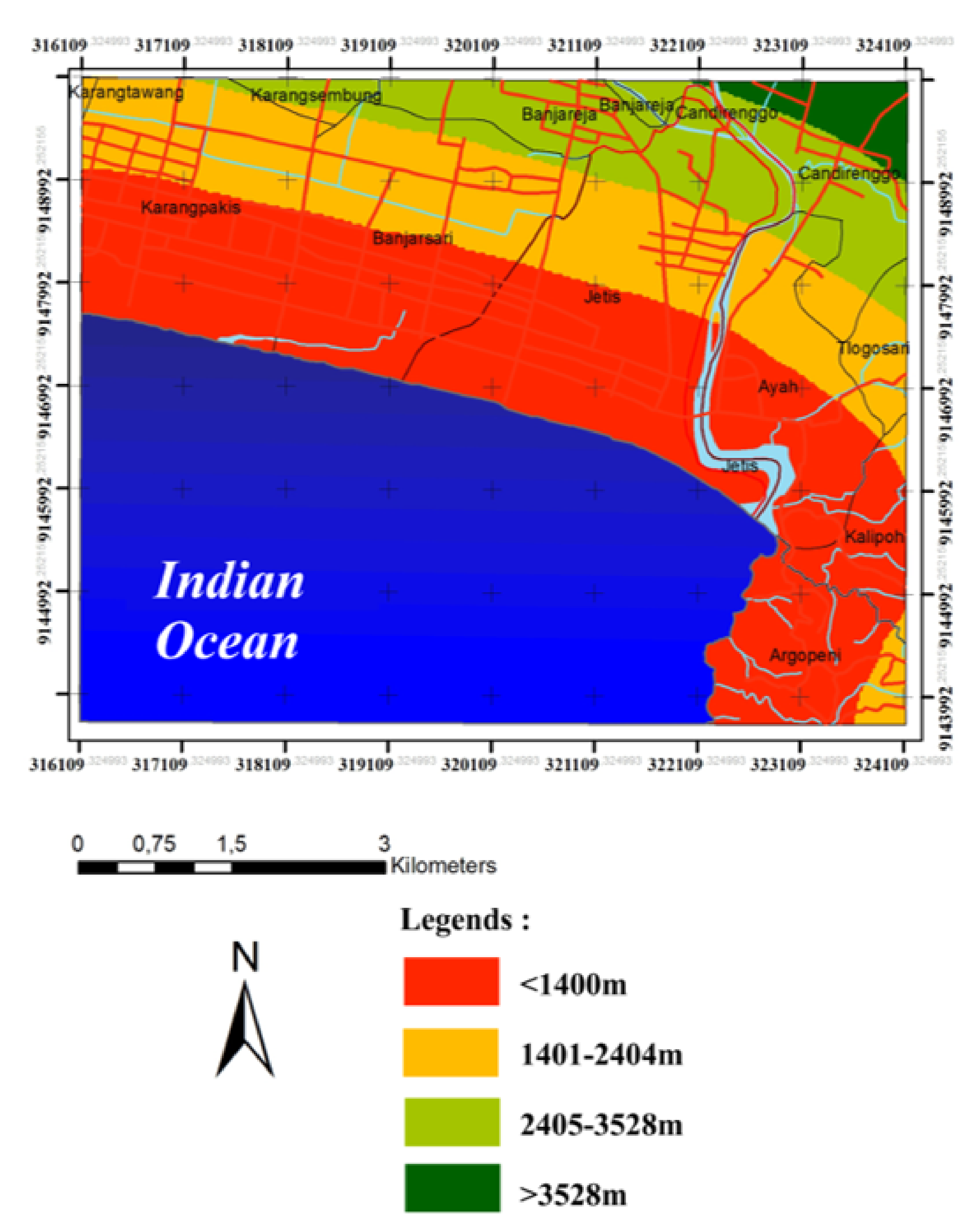
| No. | Distance (m) | Score | Weight | Total Score |
|---|---|---|---|---|
| 1 | <556 | 1 | 20 | 20 |
| 2 | 557–1400 | 2 | 20 | 40 |
| 3 | 1401–2404 | 3 | 20 | 60 |
| 4 | 2405–3528 | 4 | 20 | 80 |
| 5 | >3528 | 5 | 20 | 100 |
| No. | Distance (m) | Score | Weight | Total Score |
|---|---|---|---|---|
| 1 | 0–450 | 1 | 10 | 10 |
| 2 | 451–900 | 2 | 10 | 20 |
| 3 | 901–1350 | 3 | 10 | 30 |
| 4 | 1351–1800 | 4 | 10 | 40 |
| 5 | 1801–2250 | 5 | 10 | 50 |
| 6 | >2250 | 6 | 10 | 60 |
| No. | Percentage of Slope | Type of Slope | Score | Weight | Total Score |
|---|---|---|---|---|---|
| 1 | 0–2 | Flat | 1 | 10 | 10 |
| 2 | 2–6 | Flat–Gentle | 2 | 10 | 20 |
| 3 | 6–13 | Gentle–Tilt | 3 | 10 | 30 |
| 4 | 13–20 | Tilt | 4 | 10 | 40 |
| 5 | 20–55 | Tilt–Steep | 5 | 10 | 50 |
| 6 | >55 | Steep–Very Steep | 6 | 10 | 60 |
Publisher’s Note: MDPI stays neutral with regard to jurisdictional claims in published maps and institutional affiliations. |
© 2022 by the authors. Licensee MDPI, Basel, Switzerland. This article is an open access article distributed under the terms and conditions of the Creative Commons Attribution (CC BY) license (https://creativecommons.org/licenses/by/4.0/).
Share and Cite
Laksono, F.A.T.; Widagdo, A.; Aditama, M.R.; Fauzan, M.R.; Kovács, J. Tsunami Hazard Zone and Multiple Scenarios of Tsunami Evacuation Route at Jetis Beach, Cilacap Regency, Indonesia. Sustainability 2022, 14, 2726. https://0-doi-org.brum.beds.ac.uk/10.3390/su14052726
Laksono FAT, Widagdo A, Aditama MR, Fauzan MR, Kovács J. Tsunami Hazard Zone and Multiple Scenarios of Tsunami Evacuation Route at Jetis Beach, Cilacap Regency, Indonesia. Sustainability. 2022; 14(5):2726. https://0-doi-org.brum.beds.ac.uk/10.3390/su14052726
Chicago/Turabian StyleLaksono, Fx Anjar Tri, Asmoro Widagdo, Maulana Rizki Aditama, Muhammad Rifky Fauzan, and János Kovács. 2022. "Tsunami Hazard Zone and Multiple Scenarios of Tsunami Evacuation Route at Jetis Beach, Cilacap Regency, Indonesia" Sustainability 14, no. 5: 2726. https://0-doi-org.brum.beds.ac.uk/10.3390/su14052726