Article

The Disaster Protection System of Mountainous Rivers in Japan: The Example of the Akatani Watershed’s Reconstruction

1
Département de Géographie, Université Paris Cité, UMR 8586 PRODIG, 75013 Paris, France
2
Laboratory of Environmental Sedimentology and Sediment Hazards, Department of Maritime Sciences, Kobe University, Kobe 658-0022, Japan
3
Département SEGGAT (Sciences Économiques, Gestion, Géographie et Aménagement des Territoires), Université Caen Normandie, IDEES (Identification et Différentiation de l’Espace, de l’Environnement et des Sociétés), UMR 6266 CNRS, 14000 Caen, France
4
Département SVE (Science de la Vie et de l’Environnement), Université de Rennes, Inserm, Irset (Institut de Recherche en Santé, Environnement et Travail), UMR_S 1085, 35000 Rennes, France
*
Author to whom correspondence should be addressed.
Sustainability 2023, 15(21), 15331; https://0-doi-org.brum.beds.ac.uk/10.3390/su152115331
Submission received: 15 July 2023 / Revised: 3 October 2023 / Accepted: 16 October 2023 / Published: 26 October 2023
(This article belongs to the Special Issue Water Resource Management and Sustainable Environment Development)

Abstract

:
On 5–6 July 2017, an unstable atmospheric condition caused an unusual concentration of rainfall above the Northern part of Kyushu Island, triggering a set of hydro-meteorological hazards. Within the affected area, the mountainous subwatershed of the Akatani River was significantly impacted by numerous landslides combined with debris flow and floods. National and local agencies deployed a plan of reconstruction to restore the floodplain and protect inhabitants. Regarding the hydrosystem in the Akatani watershed, this reconstruction project mainly focuses on the restoration of damaged protection systems and the construction of new infrastructures. Thus, this paper aims to explain the restoration plan of the Akatani River in terms of the strategic Japanese River System Sabo and then as a model of a national-scale spatial plan. It draws on (i) a literature review based on the historical evolution of Japanese protection systems and the River Sabo System; (ii) field surveys in 2019, 2022 and 2023, in conjunction with (iii) interviews with local, regional, and national officials; and (iv) a Geographical Information System analysis of previously and newly built protection systems through aerial photograph interpretation and geospatial data. Sabo works implemented in the Akatani watershed illustrate the engineering vision of Japanese river management. They also constitute a comprehensive system and include a downstream–upstream logic which echoes that of the River System Sabo. In addition, the disaster of July 2017 and the government’s response emphasize the continuous adaptation and improvement of the Japanese disaster management system, which mitigates severe disasters.

1. Introduction

Since the end of the 20th century, Western river management methods have been moving towards restoration and renaturation dynamics, gradually taking into account landscape and environmental issues [1], such as river redevelopment in France and the United State and the Water Framework Directive (WFD) in Europe [1,2]. This type of management, defined as “integrated”, seeks to find a balance between passive restoration, allowing self-restoration of the system, and active restoration based on heavier engineering operations.
River management policies have also evolved in Japan, notably with the public’s growing awareness of ecological issues, starting in the mid-1950s, because of pollution issues [3]. This led to a greater emphasis on environmental issues, for example, with the restoration of rivers and the adaptation and removal of protection structures [4,5]. Non-structural measures were also introduced and have improved since the 1970s [6]. However, river management based on hard engineering is still a widely applied option, particularly in the wake of large-scale disasters.
The archipelago is subject to a variety of natural hazards, such as hydro-gravity hazards. This is partly explained by its location in a cyclonic area and its topography, which is 70% mountainous [7]. Characterized by an average catchment area smaller than major European watersheds, steep slopes and an often pronounced longitudinal profile, Japanese hydrosystems enable rapid concentration of runoff and an efficient transfer of water and sediment from erosion zones in the fluvial system to the sea [8]. These spatial characteristics, combined with the high concentration of issues along the coast and in the alluvial plain, partly justify the use of hard engineering. However, the current situation is also the result of socio-political changes [9]. Due to the importation of Western techniques, the opening of Japan during the Meiji period is a critical point in the development of its disaster management system. It influenced Japanese erosion control work, known as “Sabo works”. Sabo works are understood as structures protecting devastated areas and limiting the rise of the riverbed downstream [10]. Taken as a whole, they can be considered a complete “system” [11]. Planned from the erosion’s sources in mountainous areas, to rivers’ outlets, the control of sediment movements is considered at a watershed-scale through the “River System Sabo” (RSS) [12].
On 5–6 July 2017, a hydro-gravity disaster struck the Northern Kyushu region. The subsequent reconstruction planned by local and national authorities utilized the national Sabo-based management model. This disaster and the reconstruction plan apply to our study area, the Akatani watershed (AK).
The aim of this contribution is to demonstrate that the reconstruction of the AK watershed is representative of Japan’s national post-disaster reconstruction strategies, which are based on hard engineering management. We also intend to put these river management approaches into perspective using other potential choices of watershed management approach.
To understand contemporary post-disaster reconstruction strategies, this contribution essentially looks back at the origins and development of the Sabo system and the RSS. The extensive use of Sabo works in the Northern Kyushu restoration plan illustrates the hard engineering vision of Japanese erosion control and the actual techniques employed in Sabo works. Moreover, we advocate that Sabo works constructed in the AK watershed constitute a comprehensive system, managing sediment-related hazards from their source of production to the AK river outlet. Thus, this organization echoes the characteristics of the RSS.
A significant review of the literature was also carried out, sorting and valorizing bibliographical sources to propose a chronology of the Sabo system’s development in Japan, and to present the management logic represented by the RSS. To characterize the recent restoration plan of the AK watershed, (i) fieldworks were carried out from 2019 to 2022, (ii) interviews were conducted with national and local officials, and (iii) Geographical Information System (GIS) was used to create a database of Sabo works in the AK watershed.

2. Study Area

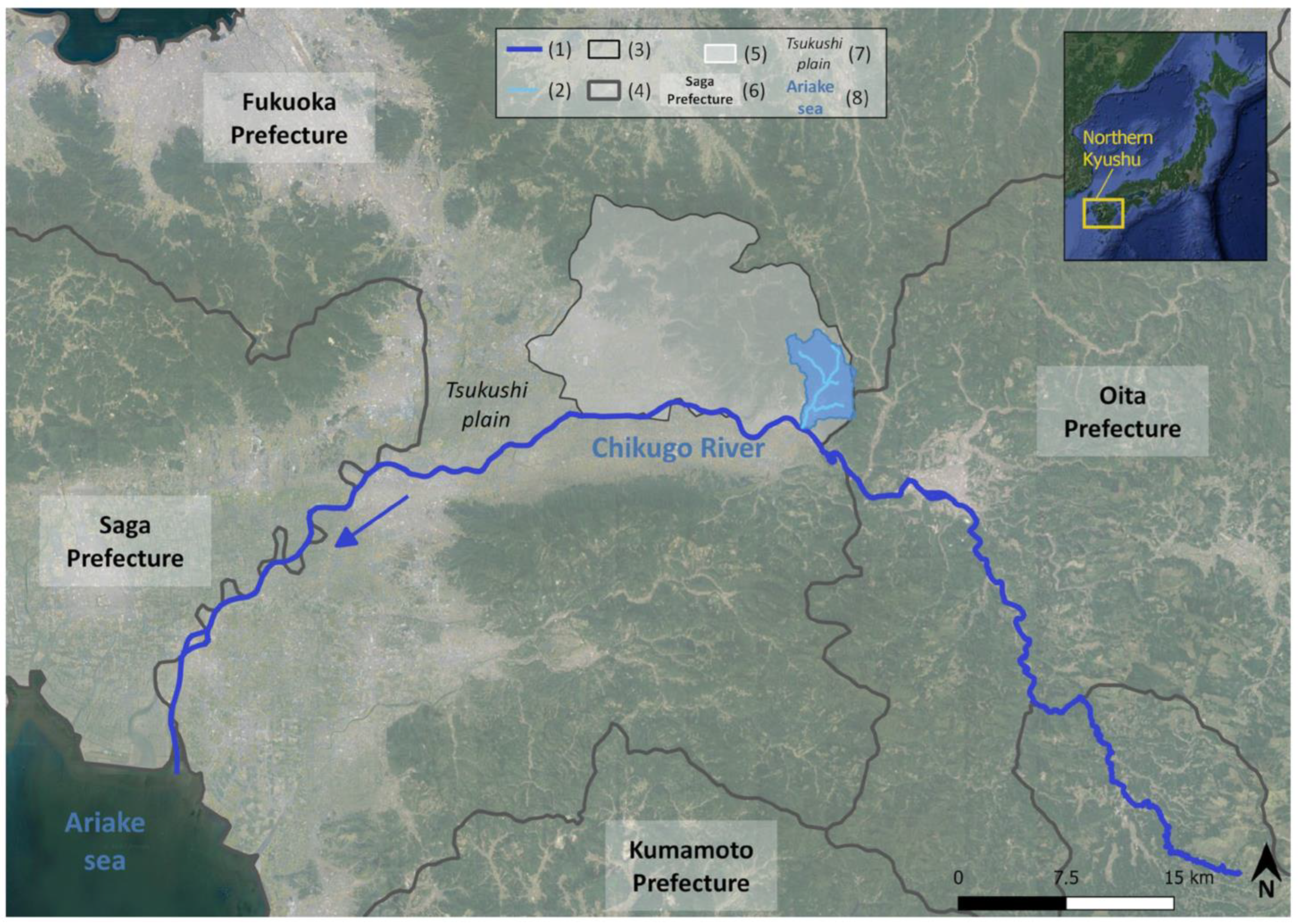
2.1. Presentation of Akatani Watershed

The AK watershed is located on Kyushu Island (southern Japan). It is a right-bank tributary of the Chikugo River, in the Tsukushi plain (Figure 1). Covering an area of around 20 km2, the AK watershed is drained by four main rivers (Akatani, Otoishi, Kogouchi, and Oyama), with headwaters in mountainous areas (Figure 1).
The AK watershed is in a subtropical climate, according to Köppen’s classification, with an average annual temperature of 15.9c. Average annual precipitation reaches 1860 mm, with a peak around June and July during the rainy season (baiyu) and typhoon season. The hydro-gravity hazards identified in this region are generally related to baiyu [13].
The AK watershed is administratively related to Asakura city, and more specifically to the Haki and Masue districts. With 50,767 inhabitants in 2023, Asakura is characterized by depopulation and aging population phenomena. Locally, these trends were amplified by the disaster of 5–6 July 2017. In the Tsukushi plain, the Haki district is more vulnerable than in the upstream part. There, steep slopes and narrow valley bottoms induced the concentration of stakes into hamlets.

2.2. Context of the 5–6 July 2017 Hydro-Gravity Disaster

On 5–6 July 2017 (J17), a baiyu front originating from South Korea became stationary above the Northern Kyushu region due to its interaction with a hot and humid air mass in the Tsushima strait. This stationary front led to a high concentration of rainfall, which reached up to 586 mm in 24 h in the central part of Northern Kyushu [14]. The temporally and spatially concentrated rainfall triggered several hydro-gravity hazards, resulting in thousands of landslides occurring in the mountainous forested areas [15] (Figure 2). A large amount of sediment supply and driftwood from forested areas increased the flood’s strength and flood-related damage. The rainfall rate estimated during the J17 was characterized by a recurrence interval greater than 1:200 [16], leading to a low-occurrence and a high-magnitude hazard. The Fukuoka prefecture, wherein the AK watershed is located, reported an estimated 220 million yen in damage and 3000 destroyed houses. The Fukuoka and Oita prefectures registered 41 dead or missing people, including 22 individuals in the AK watershed [17].
In response to the extensive damage caused by the hydro-gravity hazards, local and national authorities firstly implemented an emergency reconstruction plan to restore critical infrastructure and protect inhabitants from other potential secondary hazards. In December 2017, the Japanese government enacted the “Northern Kyushu Emergency Flood Control Project” for a five-year period following the emergency management of the disaster. This plan aims to “prevent and mitigate other disasters” by reinforcing flood control functions in the damaged rivers, such as the AK River [19]. The reconstruction effort primarily focuses on rivers (geometry, slope angle) and erosion control works (dams and sediment deposit areas) [19]. This project is strongly based on structural measures, and echoes the traditional position of Japan’s sediment-related hazard prevention and mitigation measures, which have been centrally developed since the Meiji Restoration (1868).

3. Materials and Methods

3.1. The Evolution of Japanese Natural Disaster Risk Management and the Place of Sabo Works

The reconstruction of the AK watershed illustrates the actual River System Sabo (RSS) and Sabo practices. To understand the strategies applied to our study area, we consider the importance of presenting the evolution of natural disaster management and the logic of RSS management. These systems have inherited a long history in disaster management (mitigation, prevention) entwined with Japan’s socio-historical and political context. To verify this hypothesis, we created a timeline showing evolutions in terms of natural disaster risk management in Japan by sorting and valorizing resources related to disaster management and Sabo works. We divided this timeline into three distinct time periods (Table 1).
In addition to the timeline, we present the functionalities of Sabo works and their typology issued by the Japanese government (2017) [29]. This typology highlights the diversity and specificities of Sabo dams in comparison with the AK watershed’s structures. The description of the Sabo works’ framework is based on the work of Okubo et al. [30]. The compilation of these materials will be used to analyze the AK watershed’s reconstruction process and the classification of constructed Sabo works.
Finally, we assumed that the reconstruction of the AK watershed illustrates the Japanese RSS. To verify this hypothesis, we firstly gather official documentation to present the concept of RSS and its application to watersheds. It will then be compared to the sub-watershed of the Otoishi (OT) River.

3.2. The Reconstruction of the Akatani Watershed Strongly Relies on Hard Engineering

The study of the RSS and Sabo systems provides the basis for current Japanese river management, in which the use of hard engineering has a crucial role. Consequently, our second hypothesis is that the reconstruction of the AK watershed strongly relies on this hazard management logic. To verify it and the relationship between the strategy applied to our study area with the RSS and Sabo systems, we took the following steps, resumed in Figure 3:
  • We carried out three fieldworks (February 2019; May, August 2022; April 2023) to consider the reconstruction procedure’s evolution and the scale of the constructed protection works, with the multiplication of Sabo dams in some areas (inventory).
  • We interviewed national and local actors in the reconstruction plan (City Hall, Fukuoka Prefecture, MLIT). We addressed several subjects, such as the evolution of protection structures before and after J17’s disaster, or the role of each actor in the reconstruction. We also went with officials on the field to benefit from explanations. Through meetings, we obtained official documents related to the constructed Sabo works and the AK’s reconstruction plan.
  • We created a database of protection structures constructed in the AK watershed using GIS. Data were collected from various sources, including official documents and drone videos recorded by the MLIT of Kyushu in March 2022 and posted on YouTube©. In addition, photointerpretation of aerial photographs from 2009 and 2017 and satellite images from 2022 helped to verify the dates of construction and the typology of structures that may have incomplete information.
Within the AK watershed, the OT sub-watershed was chosen to study the reconstruction applied to the area in detail and relate it to the RSS and Sabo systems. The choice to focus on the OT sub-catchment can be explained by (i) the large sediment volume supplied by the sub-catchment during the J17 event, (ii) the diversity of structures built in the sub-catchment, and (iii) its size, which enabled a more detailed analysis.
Figure 3. Summary of hypotheses and methods.
Sustainability 15 15331 g003

4. Results and Discussion

4.1. River System Sabo and Sabo in the Hydrosystem

To analyze the reconstruction plan adopted in the AK watershed after the J17 disaster, it is essential to present and examine the definitions and the historical context of RSS and Sabo practices.

4.1.1. The Japanese River System Sabo

In Japan, Sabo works can be constructed at the local or regional scale. This difference can be used to categorize these works as one of two models: the “River System Sabo” (suikei sabo, 水系砂防) and what we can call the “Proximity System Sabo” (chisaki sabo, 地先砂防) (PSS). According to the MLIT of Kyushu [31], the River System Sabo refers to countermeasures (engineering) controlling sediment transfers downstream from collapsed areas located in the headwater. Sabo works play a crucial role in preventing sediment flux in watersheds by limiting erosion and controlling the rise of the riverbed due to sediment accumulation downstream, which can lead to inundation [12,31]. The RSS suggests comprehensive erosion control management, considering the upstream–downstream continuity in sediment transfers, with a commitment to protect issues located downstream and mitigate hydro-gravity hazards there.
In contrast to the River System Sabo (RSS), the “Proximity System Sabo” refers to countermeasures taken specifically to reduce or prevent sediment-related disasters in close proximity to vulnerable entities located in mountainous areas or at the exit of a valley [31]. Here, Sabo works are primarily considered at a local scale, focusing on vulnerable entities close to the hazard area. In this context, upstream–downstream logic is not as prevalent as it is in the RSS.

4.1.2. Sabo’s Functionalities, Forms, and Construction Materials

“Sabo works” refer to a multitude of infrastructures related to hydro-gravity and sediment hazard mitigation. Based on the Sabo organization conducted by the Ministry of Construction, Okubo et al. [30] provide an accurate and comprehensive approach to Sabo schematic configuration for debris flow (Figure 4). They studied Sabo functionalities, which were compiled into five functionalities (Table 2).
Sabo works can be considered a comprehensive system in which infrastructures are dependent on one another in the watershed [30]. A wide range of Sabo types have been developed to cope with the inherent purposes. The MLIT compiled twelve main types of Sabo dams in 2017, classified by their form, functionality, and the principal materials used (Figure 5). Two main forms of Sabo dams exist in Japan: open-form (a) and closed-form (b). The (a) form allows water flow while capturing medium- and large-scale debris such as driftwood or rocks. The (b) form works via sedimentation. According to the MLIT [29], a third form of Sabo dams exist: semi-open-form Sabo dams (c), which combine capture via sedimentation and via blockage [32].
The twelve main types of Sabo dams currently classified by the MLIT are the result of a long history of managing hydro-gravity hazards in conjunction with the development of techniques and materials. Laboratory experiments and field investigations have analyzed the effect of Sabo works on hydro-gravel phenomena. Studies have examined the influence of Sabo dams on driftwood and sediment capture [33,34]. These elements have also been verified in situ, such as the effectiveness of steel open-type Sabo dams on sediment and driftwood capture at Mount Aso (Northern Kyushu) [35].

4.2. History of Disaster Management Systems and Sabo Works

Currently, the Japanese government employs various instruments, including non-structural measures and legislative tools, to protect the population and limit damage caused by natural hazards. However, the engineering approach to hazard management remains predominant and is deeply rooted in a long historical tradition [8]. The Meiji Restoration (1868), which involved a forced opening to Western countries, and the aftermath of World War II remain key moments in the evolution of disaster management systems (Figure 6).

4.2.1. From the Yamato Period (AD 250–710) to Meiji Restoration (1868)

The oldest found structure dates from the Yamato period, starting in the second half of the 3rd century [8]. The “Manda embankment”, constructed on the Yodo River (Figure 6 and Figure 7), is one of the oldest Japanese flood control projects [8].
Generally, flood protection structures were applied nearby communities or agricultural and forested areas to limit a river’s energy [8]. To stabilize Japanese everyday life and agricultural areas, flood management became a political issue from the 16th century. At the local scale, feudal lords governing a fief or a clan, called daimyos, played an important role in the restoration of agricultural systems and river management [8].
Until the Edo period (1603–1867), Sabo measures mainly focused on the protection of forested areas [21]. However, large-scale projects involving engineering were also planned, such as the Tone River project (Figure 6 and Figure 7). To protect Edo city (Tokyo) from natural hazards and societal issues, Tone’s watercourse has been diverted [8]. The project ended in 1654 with the river flowing into the Pacific Ocean instead of Tokyo Bay. Its management continued to evolved in line with scientific advances and major disasters until the 21st century [9]. The Edo period was marked by noticeable changes in natural hazard management, moving from what Totman calls an “expansionist logic” before the 18th century to a “preservationist period” [20]:
  • Expansionist logic was characterized by the management of small-sized rivers and upstream exploitation with deforestation. It led to an increase in rainfall runoff processes, improving erosion and rivers’ sediment charges. Those new modes of exploitation impacted large-scale plains, wherein sediments settled down because of the lack of a retention system upstream. This lack of retention was mainly due to the straightening of meandering rivers, and riverbank cleaning was needed to maintain irrigation systems. Faced with these consequences, protection works were undertaken downstream, gradually encroaching flood plains, while agricultural areas and inhabitants came closer to rivers.
  • During the preservationist period, the aim was to control large-scale rivers, which were not considered as “user-friendly” [20], especially to maintain the production rate. At this time, the deforestation process also strongly decreased.
The Edo period also represents the beginning of check-dams work. In the Hiroshima prefecture, some dams constructed on the Dodo River are typical of the constructions of this time [36].

4.2.2. From the Meiji Restoration to Post-World War II

After a long period of land-use management carried out by local administration, the central government took over the administration of all territory in the Meiji era (1868–1912), making a “modern unified country” [21]. This period is characterized by the introduction of new materials and techniques imported from Western countries, and the participation of foreign experts in applying those techniques in Japan [20,21]. We can mention some well-known experts in the creation of Sabo works, such as Cornelis Johannes van Doorn and Johannis de Rijke from the Netherlands [4,9,21]. Johannis de Rijke assisted Japan in developing Sabo techniques for thirty years, and had a great influence on the Japanese government. He emphasized the importance of sediment and erosion control works, but also forest conservation and the comprehensive management of rivers [21,27,37]. Another important figure in the development of Sabo was the Austrian Amerigo Hofman, who arrived in Japan in 1903 [37]. His participation strengthened the relationship between Japan and Austria, bringing with him Austrian, but also French, expertise [21,37]. Among new materials, the use of concrete, influenced by the engineer Makoto Kaba, was a key change that occurred during the 20th century [21]. Ashiyasu dam on the Midai River (Figure 7) was the first dam constructed with this material, in 1915. Concrete also played an important role in land-use planning globally, reducing interest in slope works [21]. From this time, works were more focused on storing sediment than reducing sources of erosion.
Japanese experts also contributed a lot to the development of Sabo, such as Kitaro Moroto, Masao Akagi, and Makoto Kaba during the Taisho (1912–1926) and Showa (1926–1989) eras. Kitaro Moroto used his time in Austria to learn about European erosion control works, and was one of the first Japanese people to teach Sabo construction mechanisms at Tokyo University, from 1912. He described the Sabo technologies of his time in his book “Water Regulation and Sabo Engineering: 1916” [21,25].
Masao Akagi, who also studied in Austria, considered Sabo the basis of flood countermeasures [21]. He had a great influence on Sabo works of the early Showa era, and his biggest project was the Shiraiwa dam on Joganji River, starting in 1929 (Figure 7). As it is the tallest Sabo dam in Japan [38], and the most advanced technologies were used for its construction at the time [26], Shiraiwa dam demonstrates the Showa period’s constructions. Masao Akagi also greatly influenced actual construction methods through his book “Torrents and Sabo engineering” [21].
Makoto Kaba, a contemporary of Masao Akagi, played a crucial role in the use of concrete in Sabo construction, and he considered that large-scale dams with a great capacity for sediment storage were the best solution for stabilizing rivers [21]. Consequently, Sabo dams were greatly promoted from 1927 in the archipelago, with the development of competition between several territories for the construction of large-scale dams [21]. However, the World War II imposed a break in construction works due to lack of labor force, materials, and funding [21].

4.2.3. From Post-World War II to Present

After the war, the development of dams was based on the American model, the “Tennessee Valley Authority” (TVA), which was considered by Japanese intellectuals to be the solution to resource problems and population growth [24]. This development is based on pre-war flood control works with the addition of American hydroelectric systems [39]. In addition, the government based their land-use plans on the “promotion of high-cost multipurpose large-scale dams” [23]. This led to a general increase in the dams’ costs and the so-called “heyday of Sabo project” [21], which slow downed during the 1990s.
During this time, several hydro-gravity-related countermeasures were developed [27]. The 1970s were also marked by the development of non-structural measures, which were expanded in the 2000s [27]. We can point to the amendment of the Flood Control Act in 2000, which aimed to add new rivers to the flood alert list and announce expected inundation areas, or the amendment to the Act on Promotion of Sediment Disaster in 2014, which aimed to “improve the clear publication of sediment disaster-prone areas (publication of basic investigations) or the provision of information necessary for issuing evacuation alarms” [40]. With the revision of the River Law in 1997, which incorporates the “conservation and improvement of river environments” in its objectives, environmental issues were more frequently considered in Japanese land-use planning [8]. To improve river environments and water quality, and to preserve wildlife, river projects started to focus on “flow conservation channels and nature-oriented river works” [8]. The initiative of “Nature-Oriented Works” promoted by the River Bureau concerns a large number of urban and suburban rivers [4]. We can mention the restoration of the Tama river (Tokyo), where “artificial widening and sediment augmentation” were carried out to limit vegetated terraces, improve the development of bare gravel and sand bars, and help reduce invasive vegetation species [4]. Some contemporary Sabo works are along this line, such as the modification of Uesugi-Tani River’s Sabo dams (Figure 7) to match with the new technical norms of construction [28,41]. Despite these new techniques and an increase in consideration of environmental issues, the use of engineering and Sabo works still has a central role in disaster management.

4.3. Reconstruction of the Akatani Watershed: An Example of RSS and Contemporary Sabo

In the aftermath of the J17 disaster, contemporary Sabo techniques have been applied to the reconstruction of the AK watershed, aiming to improve flood control and limit sediment and debris deposition downstream. These goals echo the vision of the RSS model, which is based on upstream–downstream continuity. In addition, the arrangement of Sabo works in the AK watershed, particularly in the OT subwatershed, illustrates the system described by Okubo et al. [30].

4.3.1. Planification of the Akatani Watershed’s Reconstruction through the “Northern Kyushu Emergency Flood Control Project”

The J17 disaster induced severe damage in Northern Kyushu, particularly in the AK watershed. To restore damaged rivers and protect the area from similar disasters in the future, the Japanese government implemented the “Northern Kyushu Emergency Flood Control Project” (Kyūshū hokubu kinkyū chisui taisaku purojekuto, 九州北部緊急治水対策プロジェクト) [42]. To recover flood control capacity, control rivers, and limit erosion, engineering measures were placed at the center of the project. These included the construction of sediment control-related structures and the improvement of the river’s geometry and slope angle [19]. The total cost of the river’s reconstruction in the AK watershed, announced by the Northern Kyushu Emergency Flood Control Project, reached 33.6 billion yen [19]. In the case of the AK watershed, the reconstruction project is managed by the central government through the MLIT. The prefecture of Fukuoka and the city of Asakura transferred their river management skills to the ministry during the reconstruction works. Their direct actions regarding reconstruction are therefore limited. However, national and local authorities have collaborated to reconstruct the area. This situation is due to the amendment of the River Act in June 2017 [43]. The case of the AK watershed’s reconstruction is the first application of this transfer of skills in Japan.
According to the Northern Kyushu Emergency Flood Control Project, we assume that these measures are coordinated at the watershed scale to “prevent flood accompanied by driftwood and sediment” from the AK headwater to the Chikugo River confluence [19]. Thus, the AK watershed’s reconstruction can be considered part of the RSS model. This hypothesis is strengthened by the roles and location of Sabo works briefly described by the MLIT:
  • The development of dams in mountainous areas to stop driftwood and sediment flux;
  • The development of storage facilities upstream to capture sediment and driftwood;
  • The rehabilitation of river channels and the improvement of their geometry to “smooth the flow of flood water and sediment downstream” [19].
The Northern Kyushu Emergency Flood Control Project represents the largest contemporary Sabo project that the AK watershed may have ever experienced. After a period of relative stability for its hydrosystem, the reconstruction works started in 2018 strongly redesigned a large number of rivers and slopes in the watershed [44]. The significant increase in Sabo dams from 2018 illustrates this change (Figure 8). The Sabo dams planned by MLIT in the watershed are also of considerable size. According to data supplied by the Ministry, the median height and length are, respectively, 10 m and 58 m [45]. Through the plan led by the MLIT and the construction of one Sabo dam by the prefecture, the number of Sabo dams has gone from six to thirty-seven by 2023. In addition to Sabo dams constructed by the MLIT, the Ministry of Agriculture, Forestry and Fisheries (MAFF) simultaneously constructed an erosion control system in forested areas, and took part in the modification of the AK hydrosystem.
Alongside Sabo dams, other infrastructures have been constructed: sediment deposit areas, training channels, weirs, and hillside works. Due to the magnitude of hazards, the main channels needed reconstruction. To cope with a 50 year flood hazard, which represents approximately 209 m2 in the studied cross-section including the channel and the flood plain, the MLIT reviewed the river’s geometry by straightening and widening channels [19,44]. During the reconstruction, the government followed the main path taken by the river in 2017, reducing the river’s sinuosity (Figure 9a). Now, the channel is wider and deeper than before the disaster. During the 2023 fieldwork, we calculated the evolution of the channel capacity (Figure 9b). On the cross-section, the capacity went from 32 m2 before 2017 to 185.5 m2 after recalibrating the cross-section of the channel. The new channel is in former agricultural fields, which were destroyed by the flood and covered in sediment (Figure 9a). Despite some damaged houses, the inhabited areas remain stable. A road and a pedestrian/bicycle pathway have been added in the reconstruction plan. Right-bank inhabited areas that were inundated in 2017 are now protected by the new dike. The previous channel still exists, and may become a discharge area during floods, limiting inundation.
Alongside these major physical modifications to slopes and rivers, the Northern Kyushu Emergency Flood Control Project also includes non-structural measures such as (i) equipping rivers with water level gauges triggered by a significant rise in water level, (ii) transmitting emergency information to residents via cell phone, (iii) improving education on natural hazards, and (iv) studies on urban planning [19]. Thus, since 2018, the AK River has been officially equipped with a water level gauge downstream of the confluence with the OT River, recording variations during crises. The J17 event also led to the revision of the voluntary disaster prevention map (jishu bōsai mappu, 自主防災マップ) map, drawn up at a communal scale based on national and prefectural data with the participation of residents. The map is regularly updated, most recently in March 2023.

4.3.2. The Reconstruction of Otoishi River as an Illustration of Contemporary Sabo Techniques

The OT subwatershed has generated about 1.5 million m3 of the estimated 3.5 million m3 of the J17 sediment runoff in the AK watershed [46]. It was the primary source of sediment runoff in the AK watershed during the disaster. Thus, its management is crucial for the entire downstream area. By focusing on the OT watershed, we can analyze similarities between the schematic arrangement examined by Okubo et al. [30] and the reconstruction plan led by the Northern Kyushu Emergency Flood Control Project, which reflects the RSS. The Sabo works undertaken in the OT watershed can be seen in Figure 10, which presents five types of Sabo works implemented within the watershed: (1) Sabo dams; (2) weirs; (3) channels; (4) a sediment deposit area; and (5) hillside works. Figure 10 summarizes the undergoing reconstruction works, digitalized with the help of 2022 satellite images.
The OT watershed includes sixteen out of the thirty Sabo dams built after the J17 disaster (Figure 10). The three main forms of dam previously listed by the MLIT are represented in the OT watershed. Due to ongoing construction works, some uncertainties may remain between close- and semi-open forms and the exact sub-type for some open-form Sabo dams. There are also difficulties in erosion slope works which are rapidly constructed. However, official documents, fieldworks, and recent drone videos help to define them as precisely as possible.
Apart from #01 (numbers attributed by the MLIT, e.g., Otoishi 01 [45]), Sabo dams are constructed nearby the main channel of OT River, or within its riverbed (Figure 10). Regarding their location, they can be divided into two main groups:
  • Sabo dams constructed on the left bank of the OT river: Nearby the main channel, between 147 and 278 m in altitudes, these Sabo dams are assigned at the exit sub-watersheds [45]. Some of them recorded large landslides in J17 such as sub-watersheds #19, #21 and #25.26 (Figure 10). All the infrastructures are designed to capture large-size debris and driftwood from upstream. This also applies to Sabo dam #31, which is equipped with a deposit area downstream, enclosed by steel frames. These structures and their location illustrate the “capture debris flow” function presented by Okubo et al. [30]. By capturing debris from mountainous areas, those dams limit debris flowing downstream the OT river main channel, and then protect the AK watershed at an early stage. However, some dams may also directly protect remaining issues located nearby, such as dams #21, #29, #30 and #31 (Figure 10 and Figure 11b,c). In fact, some inhabitants came back to this area after the lifting of “long-term evacuee” status [47]. Despite the remaining small-scale urban sprawl, we can assume that most of the dams are constructed to protect the downstream part of the AK watershed from hydro-gravity hazards.
  • Sabo dams constructed in the headwater of the OT River: Between 276 and 351 m in altitude, a set of Sabo dams have been planned in the upstream part of the OT River (Figure 10). In total, six of them are constructed in the sub-watershed #15, with one steel-frame dam and five gravity dams. Located in a heavily damaged area, they are meant to manage sediment flow from six different sub-watersheds [45]. At 351 m, dam #15-6 is designed to capture large-size debris, such as driftwood, while dams #15-1 to #15-5 capture sediment and smaller-scale debris, and may reduce flow strength. Due to the large amount of sediment flowing from the OT watershed, capturing sediment runoff in the headwater is crucial. As for the dams located on left bank, the upstream area has experienced a decrease in urban sprawl due to the registered damage. Before 2017, the OT watershed hosted four hamlets. The hamlet of Otoishi in the upper basin has been mostly destroyed by the disaster. However, houses that were spared by the disaster were demolished in the aftermath, and gave way to this set of Sabo dams (Figure 11a). The decrease in urban sprawl in the OT watershed in favor of large-scale Sabo dams, which protect the downstream area, exemplifies the global vision of the RSS.
The last Sabo dam constructed in the OT watershed is located downstream, at an altitude of 122 m (Figure 10 and Figure 12d). It is coupled with a sediment deposit basin upstream of the river constriction area. In addition to the role of sediment deposition and the dissipation of the flow’s energy generally conferred to sediment deposition areas, this structure has other merits, which are specific to the OT watershed’s context [30,46]. The development of a sediment capture area on its left bank will help to stop sediment as well as debris from the sub-watershed, wherein no Sabo dam was constructed. The importance of such a capture structure in this area was confirmed during two floods in 2018 and 2019; during each event, temporary structures trapped about 15,000 m3 of sediment, protecting downstream areas [46]. Thus, the function of these Sabo dams can be defined as “capturing debris flow”, and the sediment basin as a “deposit area for debris flow” (Figure 12a).
In addition to Sabo dams, various works have been implemented in the OT watershed. Regarding slope stabilization, several techniques have been used such as geotextiles, terraces, or shotcrete grid beam structures (Figure 10 and Figure 12b–e). These measures may be located on eroded slopes where landslides were triggered in 2017, as well as near new structures to stabilize the surrounding slopes (Figure 12b). In the upstream area, where a significant landslide occurred, hillside works are still under construction (Figure 12c). Many digitalized structures are also located near houses, such as downstream, and may directly protect them. Until reconstruction is completed, blue tarpaulins are generally used as temporary emergency measures to limit erosion (Figure 12b). Hillside works directly influence the production of sediment run-off, limiting the occurrence of hazards. According to Okubo et al. [30]’s classification, they can be considered a “restriction hazard occurrence” (Figure 12a).
Weirs complete the reconstruction of the main river channel, reducing flow strength (Figure 10). They are currently concentrated between the set of Sabo dams upstream and the deposit area downstream. Some weirs nearby the confluence with the AK River are also visible in 2022, and others may have been constructed since the 2022 satellite images were taken. In addition, weirs located upstream do not stay in the final organization, as they seem to be temporary emergency measures.
In addition to the main channel of OT river, we can find some secondary training channels along slopes (Figure 10 and Figure 11b). They are constructed to control waterflow from the left bank side of the OT river, but also to irrigate paddy fields that are still under construction. On the right bank of the OT River, some of them also connect Sabo dams on the right-bank side to the main channel through culverts (Figure 10 and Figure 12c,d).
The reconstruction plan of the OT watershed illustrates the diversity of Sabo works covered by the Northern Kyushu Emergency Flood Control Project, in which structural measures are central. Adapted to the watershed context, these structures are dependent on one another, and constitute a comprehensive “system” that illustrates the classification of Sabo works carried out by Okubo et al. [30]. They are also integrated at the watershed scale, protecting the downstream part of the AK watershed from hydro-gravity hazards. Despite some structures that may directly prevent issues, echoing the PSS vision, major Sabo works are part of the RSS, integrating an upstream–downstream logic and limiting erosion processes in mountainous upper basins.

4.4. Discussion

The reconstruction of the AK watershed, as planned by the Northern Kyushu Emergency Flood Control Project, exemplifies the contemporary application of Sabo works in severely damaged areas. It demonstrates a large panel of Sabo dams and other infrastructures that have been adapted by the Japanese government from foreign techniques to suit the country’s specific territory. In the AK watershed, Sabo works should be considered a whole “system”, as previously described by Okubo et al. [30] and shown by the reconstruction of the OT subwatershed. The comprehensive approach taken in the AK watershed reconstruction project further supports this hypothesis, and proves that this project can be considered part of the RSS model and part of the classical vision of the Japanese government in terms of hydro-gravity hazard management. The system presented by Okubo et al. is also similar to erosion control systems applied abroad in mountainous areas, such as the torrential correction dam system in France described by Piton et al. [48].
Through the application of the RSS in the AK watershed, the upstream part of the watershed has been extensively equipped with Sabo works. To protect downstream vulnerable areas, the main upstream area is used as a sediment trap and a sediment storage zone. Consequently, the reconstruction project leads to a clear division of the watershed into two distinct parts: (i) the heavily modified upstream area, which contributes to the reduction of hydro-sedimentary hazards; and (ii) the downstream area, relatively preserved from the infrastructure implementation.
The Sabo system suits high-energy, torrential rivers, and is used to modify the sediment cascade. It is generally effective when several dams are set up in the valley, attenuating slopes, and hydraulic energy, promoting sediment storage upstream of each of the structures, and limiting erosion at the foot of the slopes. The field work we have carried out leads us to believe that Japanese engineers design very sophisticated and extremely effective Sabo systems. Each structure is adapted to the specific features and physical constraints of the field. Mountain catchments may be subject to extremely powerful flash floods and landslides. The hydro-climatic context of Japan, its topography, and the average small size of its watersheds contribute to the high occurrence of hydro-gravity hazards. When this risk in underestimated, hazards can induce severe damage. Before 2017, river and erosion control structures were not calibrated to cope with the high-magnitude hazard of 5–6 July. Thus, the reconstruction of the AK watershed was necessary, and the Sabo system is suitable for this context.
In mountain catchments subject to extremely powerful rivers and flash floods, hard engineering works remain crucial. The objective is to ensure the protection of populations living downstream of mountain catchments. However, we stress the importance of taking into consideration the impact of these structures on the community and the landscape. To protect the population in Tsukushi plain, ancient hamlets were not rebuilt after the disaster, leaving space for large-scale Sabo dams and leading to the relocation of inhabitants. Japan also tends to install heavy structures in large floodplains that are quite far from mountain catchment areas. Despite demographic pressure, the combination of engineering structures and flood expansion zones can be discussed.
We can say that Japanese disaster prevention measures are advanced. Japan has exported its measures overseas in South East Asia, helping to control and reduce hydro-gravity hazards. However, the application of these hard engineering measures is expensive and Japan, like other countries, faces maintenance issues [2]. For example, Chanson in 2004 highlighted the need for the maintenance of these infrastructures, and their implications for a “long-term vision” in Japan and overseas [49]. The maintenance of the system applied to the AK watershed may be a challenge for prefectoral and municipal entities in the future. We must highlight that the reconstruction of the AK watershed was financially and technically supported by the central government, as the River Act allows. However, the maintenance of the infrastructure will return to prefectoral and municipal authorities. Despite the development of strategies to reduce the cost of maintenance, it will be important to see the actual cost of these structures in the future.
Thus, no matter how good a hydraulic structure is, no structure is immune to damage and destruction from floods and landslides. The heavy rainfall of 2018 and 2019 showed the effectiveness of constructing protection structures within the OT subwatershed [46]. As expected, the urbanized area downstream was protected. In July 2023, heavy rainfall proved again the effectiveness of the Sabo system in the AK watershed. The constructed Sabo works did limit flood expansion, and there was no human loss. However, there was material damage [50]. The rainfall also showed the limits of the engineering system. In Asakura city, the cost of damage to inhabited areas represented 10% of recorded damage in 2017. The agriculture and civil engineering damage accounted for 60% of 2017 costs [50]. Landslides did happen in mountain areas, and some new protection structures, such as dikes, were already damaged. So, despite the effort invested in the construction of protection structures through hard engineering, we stress that it is not possible to completely erase risk. Additionally, it is important that the existence of protection structures does not lead to a false sense of security for populations living in hazard-prone areas.

5. Conclusions and Recommendation

Currently implemented Sabo works have inherited a long hydro-gravity hazard management history, which has been influenced by significant events such as the opening of the Japanese archipelago at the end of the Meiji Restoration. The engineering vision remains deeply rooted in hazard protection and mitigation policies, which is justified by the frequency and intensity of hydro-gravity hazards experienced in Japan.
Engineering cannot completely protect against hydro-gravitational hazards, and it is necessary to pursue the development of non-structural measures at the same time. It is important to note that the 2017 disaster highlighted a lack of risk memory in the AK watershed. It seems that several residents had a feeling of safety in the region before the disaster of J17.
In addition to engineering measures, improvement in and the development of non-structural measures remains essential to reduce the vulnerability of the population. Generally speaking, a balance must be struck between the vulnerability (stakes) of societies and measures to manage the hazard, in order to reduce the hydro-gravity risk. This idea can be observed in Figure 13. Appropriate hazard management measures reduce the vulnerability of the population regarding structural and human stakes in floodplains (a3). When vulnerability remains high in the face of ineffective management measures, the hydro-gravity risk persists (a2). A balance can be struck between persistent but deemed-acceptable vulnerability and hazard management measures developed in the catchment (a1). In this case, it is highly advisable to adjust hazard management measures as closely as possible. The best way to manage hydro-gravity hazards regarding societal vulnerability in the catchment is through integrated management, with priority given to hard measures (engineering) where the human stakes (the question of people’s survival) are extremely high (in the case of densely populated areas), or soft measures in areas where the human and/or material stakes are low (b1). Management is less “integrated” when political decisions force managers to adopt either only hard measures (b3) or only soft measures (b2).
The disaster of J17 induced improvements in non-structural measures in the AK watershed. Updates to the independent hazard map between 2013 and 2017 illustrate a partial lack of knowledge of flood-prone areas before the J17 event. This shows the importance of soft tools and their regular revision. To cope with these issues, geo-historical studies may be a good approach to the considering natural risks of a territory when documents are available [52]. Other soft management ideas have recently been mentioned for Kyushu Island, such as the need for a harmonized database of past disasters and the development of their use in disaster prevention and mitigation, or the improvement of evacuation systems [53].
Whereas the reconstruction of the AK watershed is nearing completion, the summer’s rains have already shown some limits of the plan designed by the authorities. A more detailed study of the damage caused to the facilities and slopes in the AK watershed would enable us to examine more precisely the effectiveness of the system implemented here, and what should be improved. This is even more important given that the reconstruction plan applied to AK watershed has had a national scope since December 2017, used as a model that the MLIT seeks to apply to similar mountainous rivers.

Author Contributions

Conceptualization, M.D.; Methodology, M.D.; Investigation, M.D., G.A.-F. and C.L.; Writing—original draft, M.D.; Writing—review & editing, C.G., G.A.-F., C.L. and V.V.; Supervision, C.G., G.A.-F. and C.L.; Funding acquisition, C.L. All authors have read and agreed to the published version of the manuscript.

Funding

This research was funded by the “PHC Sakura” program (project number: 49671UD), implemented by the French Ministry for Europe and Foreign Affairs, the French Ministry of Higher Education and Research, and the Japan Society for the Promotion of Science.

Institutional Review Board Statement

Not applicable.

Informed Consent Statement

Not applicable.

Data Availability Statement

Data are not available online at the moment.

Acknowledgments

We also want to thank the Centre de Langues Odéon at Université Paris Cité for the help they provided regarding English proofreading and revision during the “Academic writing” class provided by Philippe Bardy. We would like to thank the editors and reviewers for their pertinent comments, which helped to improve the manuscript.

Conflicts of Interest

The authors declare no conflict of interest.

References

  1. Barraud, R.; Germaine, M.-A. Démanteler les Barrages pour Restaurer les Cours d’Eau: Controverses et Représentations; Update Sciences & Technologies; Éditions Quae: Versailles, France, 2017; ISBN 978-2-7592-2678-8. [Google Scholar]
  2. Gonzales, V.; Walls, M. Dams and Dam Removals in the United States; Resources for the Future: Washington, DC, USA, 2020; p. 33. [Google Scholar]
  3. Ohkura, Y. The Roles and Limitations of Newspapers in Environmental Reporting. Case Study: Isahaya Bay Land Reclamation Project Issue. Mar. Pollut. Bull. 2003, 47, 237–245. [Google Scholar] [CrossRef] [PubMed]
  4. Nakamura, K.; Tockner, K.; Amano, K. River and Wetland Restoration: Lessons from Japan. BioScience 2006, 56, 419. [Google Scholar] [CrossRef]
  5. Noda, K.; Hamada, J.; Kimura, M.; Oki, K. Debates over Dam Removal in Japan: Debates over Dam Removal. Water Environ. J. 2018, 32, 446–452. [Google Scholar] [CrossRef]
  6. Uchida, T.; Nishimoto, H.; Osanai, N.; Shimizu, T. Countermeasures for Sediment-Related Disasters in Japan Using Hazard Maps. Int. J. Eros. Control Eng. 2009, 2, 8. [Google Scholar] [CrossRef]
  7. Yoshimatsu, H.; Abe, S. A Review of Landslide Hazards in Japan and Assessment of Their Susceptibility Using an Analytical Hierarchic Process (AHP) Method. Landslides 2006, 3, 10. [Google Scholar] [CrossRef]
  8. Mochizuki, T.; Ueda, T. Flood Control Works in Japan—Achievements to Date and Future Outlook. IWRA 2003, 10. [Google Scholar]
  9. Nakamura, S.; Oki, T. Paradigm Shifts on Flood Risk Management in Japan: Detecting Triggers of Design Flood Revisions in the Modern Era. Water Resour. Res. 2018, 54, 5504–5515. [Google Scholar] [CrossRef]
  10. Ministry of Land, Infrastructure, Transport and Tourism. Sabo Department Sabō Kankei Jigyō No Gaiyō [Outline of Sabo Works]; Ministry of Land, Infrastructure, Transport and Tourism: Tokyo, Japan, 2021.
  11. Augendre, M. Vivre Avec le Volcan. Une Géographie du Risque Volcanique au Japon. Ph.D. Thesis, Université Lumière Lyon 2, Lyon, France, 2008. [Google Scholar]
  12. International SABO Association. Definition of Technical Term—River System Sabo. Association Website. International SABO Network. 2023. Available online: https://sabo-int.org/definition-of-technical-term/river-system-sabo/ (accessed on 15 October 2020).
  13. Ministry of Land, Infrastructure, Transport and Tourism. Chikugo Gawa No Omona Saigai [Main Disasters in Chikugo River]. Available online: https://www.mlit.go.jp/river/toukei_chousa/kasen/jiten/nihon_kawa/0916_chikugo/0916_chikugo_02.html (accessed on 30 April 2020).
  14. Ministry of Land, Infrastructure, Transport and Tourism. Kyushu Regional Development Bureau Tremendously Heavy Rainfall Has Occurred, Twice as Much as at Any Previously Recorded Time; Ministry of Land, Infrastructure, Transport and Tourism: Tokyo, Japan, 2017.
  15. Siccard, V.; Lissak, C.; Gomez, C. Des Instabilités de Versant Aux Sources Sédimentaires: Étude de La Catastrophe Géomorphologique Du 5–6 Juillet 2017 Dans Le Bassin-Versant Du Chikugo (Kyūshū, Japon). Géomorphol. Relief Process. Environ. 2022, 28, 257–271. [Google Scholar] [CrossRef]
  16. Technical Committee for the Rehabilitation of Erosion Control and River in Chikugo Right Bank Catchment. Chikugogawa Ugan Ryūiki Kasen・Sabō Fukkyū Gijutsu Kentō Iin Kaihōkokusho [Report of the Technical Committee for the Rehabilitation of Erosion Control and River in Chikugo Right Bank Catchment]; Technical Committee for the Rehabilitation of Erosion Control and River in Chikugo Right Bank Catchment: Kawasaki, Japan, 2017; p. 130. [Google Scholar]
  17. Japan Society of Civil Engineers. Heisei Nijūkyūnen Shichigatsu Kyūshū Hokubu Gōu Saigai—Chōsa Hōkokusho [Heavy Rainfall Disaster in Northern Kyushu in July 2017—Investigation Report]; Japan Society of Civil Engineers: Tokyo, Japan, 2020; p. 175. [Google Scholar]
  18. Geospatial Information Authority of Japan. Heisei Nijūkyū Nen Shichigatsu Kyūshū Hokubu Gōu Ni Kansuru Jōhō [Information Related to Heavy Rainfall of July 2017 in Northern Kyushu]. Available online: https://www.gsi.go.jp/BOUSAI/H29hukuoka_ooita-heavyrain.html (accessed on 2 February 2023).
  19. Ministry of Land, Infrastructure, Transport and Tourism. ⌈Kyūshū Hokubu Kinkyū Chisui Taisaku Purojekuto⌋ Ni Yori Kinkyūtekina Chisui Taisaku Wo Susumemasu [Promotion of Urgent Flood Control through the “Northern Kyushu Emergency Flood Control Project”]; Ministry of Land, Infrastructure, Transport and Tourism: Tokyo, Japan, 2017.
  20. Totman, C. Preindustrial River Conservancy. Causes and Consequences. Monum. Nippon. 1992, 47, 59–76. [Google Scholar] [CrossRef]
  21. Takei, A.; Tabata, S.; Itagaki, O.; Oya, K.; Sakaguch, T. Preservation And Utilization of Historic Sabo Facilities. In Proceedings of the Interpraevent 2004, Riva, Italy, 24–27 May 2004; pp. 337–348. [Google Scholar]
  22. Osugi, T.; Tate, S.; Takemura, K.; Watanabe, W.; Ogura, N.; Kikkawa, J. Ecological Research for the Restoration and Management of Rivers and Reservoirs in Japan. Landsc. Ecol. Eng. 2007, 3, 159–170. [Google Scholar] [CrossRef]
  23. Batten, L.B.; Brown, P.C. Environment and Society in the Japanese Islands: From Prehistory to the Present; Oregon State University: Corvallis, OR, USA, 2015. [Google Scholar]
  24. Dinmore, E. Concrete Results? The TVA and the Appeal of Large Dams in Occupation-Era Japan. J. Jpn. Stud. 2013, 39, 1–38. [Google Scholar] [CrossRef]
  25. Nishimoto, H. Kindai sabō wo hiraita Moroto Kitarō hakushi—⌈sanrin⌋ hoka no shiryō kara yomitoku sono ashiato—[Doctor Kitaro Moroto: Pioneer of modern sabo—Analysis of this footprint from “Forestry” and other related-documents]. Assoc. For. Jpn. 2018, 11, 52–60. [Google Scholar]
  26. Osaka, T.; Watanabe, H. Maintenance and Utilization of a Sabo Facility Designated as an Important Cultural Property—The Shiraiwa Sabo Dam. In Proceedings of the Interpraevent 2018, Toyama, Japan, 4 August 2018; pp. 277–286. [Google Scholar]
  27. Japan Landslide Society. National Conference of Landslide Control Landslides in Japan; Japan Landslide Society: Tokyo, Japan, 2002. [Google Scholar]
  28. Osanai, N.; Mizuno, H.; Mizuyama, T. Design Standard of Control Structures Against Debris Flow in Japan. J. Disaster Res. 2010, 5, 307–314. [Google Scholar] [CrossRef]
  29. Ministry of Land, Infrastructure, Transport and Tourism. Sabō Entei no Bunrui [Classification of Sabo Dam]; Ministry of Land, Infrastructure, Transport and Tourism: Tokyo, Japan, 2017.
  30. Okubo, S.; Ikeya, H.; Ishikawa, Y.; Yamada, T. Development of New Methods for Countermeasures against Debris Flows. In Recent Developments on Debris Flows; Armanini, A., Michiue, M., Eds.; Lecture Notes in Earth Sciences; Springer: Berlin/Heidelberg, Germany, 1997; pp. 166–185. ISBN 978-3-540-49729-5. [Google Scholar]
  31. Ministry of Land, Infrastructure, Transport and Tourism. Kyushu Regional Development Bureau Kawabe Gawa Sabō Jigyō [Erosion Control Works on Riversides]; Ministry of Land, Infrastructure, Transport and Tourism: Tokyo, Japan, 2009.
  32. National Institute for Land and Infrastructure Management. Sabō Kihon Keikaku Sakutei Shishin (Dosekiryū Ryūboku Taisaku Hen) Kaisetsu [Commentary on Erosion Control Basic Plan Guidelines (Compilation of Debris Flow and Driftwood Countermeasures)]; Ministry of Land, Infrastructure, Transport and Tourism: Tokyo, Japan, 2016.
  33. Namgyun, K.; Nakagawa, H.; Kawaike, K.; Zhang, H. Influence of a Serie of Sabo Dams on Debris Flow Deposition. Annu. Disaster Prev. Res. Inst. Kyoto Univ. 2013, 56, 531–538. [Google Scholar]
  34. Tateishi, R.; Horiguchi, T.; Sonoda, Y.; Ishikawa, N. Experimental Study of the Woody Debris Trapping Efficiency of a Steel Pipe, Open Sabo Dam. Int. J. Sediment Res. 2020, 35, 431–443. [Google Scholar] [CrossRef]
  35. Moriyama, H.; Kokuryo, H.; Yamaguchi, M.; Inoue, R.; Ishikawa, N.; Shima, J. Debris Flow Capture Investigation of Steel Open-Type Sabo Dams around Mt. Aso, JAPAN. In Proceedings of the Interpraevent 2014, Nara, Japan, 25–28 November 2014. [Google Scholar]
  36. Hiroshima Prefectural Government Sediment Control on the Dodo River. 2007. Available online: https://www.sabo.pref.hiroshima.lg.jp/portal/sonota/sabo/pdf/301_doudou_eng.pdf (accessed on 1 May 2023).
  37. Okamoto, M. The Transition of Sabo Works for Disaster Mitigation in Japan. In Proceedings of the International Symposium Interpraevent 2010, Taipei, Taiwan, 26–30 April 2010. [Google Scholar]
  38. Ministry of Land, Infrastructure, Transport and Tourism. Representative Sabo Facilities: Shiraiwa Sabo Dam. Available online: http://www.hrr.mlit.go.jp/tateyama/english/representative/shiraiwa.html (accessed on 27 May 2021).
  39. Gomez, C. Les grands barrages au Japon, enjeux sociétaux et environnementaux. Géoconfluences 2010. Available online: http://geoconfluences.ens-lyon.fr/doc/transv/Risque/RisqueScient4.htm (accessed on 1 January 2023).
  40. Cabinet Office. Disaster Management in Japan; Cabinet Office Japan: Tokyo, Japan, 2015; p. 49.
  41. Sabo Division, Public Works Bureau. Okayama Prefecture Remodelling Sabo Dam by Installing Slits. Int. Sabo Netw. 2019, 169, 17–19. [Google Scholar]
  42. Cabinet Office Japan. White Paper on Disaster Management 2018; Cabinet Office Japan: Tokyo, Japan, 2018; p. 237.
  43. Okuno, M. Heisei Nijūkyūnen Shichigatsu Kyūshū Hokubu Gōu Ni Yori Hisaishita Kasen No Sōki Fukkyū Oyobi Kyūshū Hokubu Gouu Nado Kyōkun Wo Fumaeta Taisaku No Zenkoku Tenkai [Prompt Rehabilitation of Rivers Damaged by North Kyushu Heavy Rain in July 2017, and Nationwide Countermeasures against Heavy Rain Based on the Lessons Learnt from the North Kyushu Disaster]. Water Sci. 2018, 62, 57–69. [Google Scholar] [CrossRef]
  44. Dumont, M.; Arnaud-Fassetta, G.; Gomez, C.; Lissak, C.; Viel, V. From the Disaster to the Forced (Re)Construction: The Example of the Akatani Catchment. Water 2023, 69, 14820. [Google Scholar]
  45. Ministry of Land, Infrastructure, Transport and Tourism. Chokkatsu Sabō Jigyō Keikaku [Direct Erosion Control Project Plan]; Ministry of Land, Infrastructure, Transport and Tourism: Tokyo, Japan, 2022.
  46. Umemoto, T.; Kawai, I.; Kitamoto, R.; Matsuki, H. “Akatani kawa ryūiki ni okeru kōkatekina dosha ryūboku hozoku shisetsu no kentō—Suiri mokei wo katsuyōshita sabō shisetsu no kentō jirei—[Examination of Effective Sediment and Driftwood Capture in Akatani River Watershed—The Case Study of Erosion Control Facilities Applied to Hydraulic Model Experiment]”. MLIT Kyushu Research Association, 1, n°3. 2021. Available online: http://www.qsr.mlit.go.jp/site_files/file/n-shiryo/R2kenkyu/1_03(31).pdf (accessed on 18 January 2023).
  47. RKB Online. Kyūshū hokubu gōu kara gonen ⌈chōki hinan shotai⌋ nintei kaijo mo shūraku zonzoku no kiki Fukuoka Asakurashi [Five Years After the Torrential Rains in Northern Kyushu, “Long-Term Evacuee” Status Has Been Lifted, but the Survival of Asakura City Community (Fukuoka) is Still in Danger]. News, 5 July 2022. Available online: https://rkb.jp/news-rkb/202207052252(accessed on 2 February 2023).
  48. Piton, G.; Carladous, S.; Recking, A.; Tacnet, J.-M.; Liébault, F.; Kuss, D.; Quefféléan, Y.; Marco, O. Fonctions Des Barrages de Correction Torrentielle. Cybergeo Rev. Eur. Géogr. Eur. J. Geogr. 2019, 32190. [Google Scholar] [CrossRef]
  49. Chanson, H. Sabo Check Dams—Mountain Protection Systems in Japan. Int. J. River Basin Manag. 2004, 2, 301–307. [Google Scholar] [CrossRef]
  50. Watanabe, S. Asakurashi no ōame higai, norintoboku ha roku nen no rokuwari kasanaru saigai [in Damages Caused by Heavy Rainfall of Asakura, Agriculture, Forestry and Civil Engineering Damages Represent 60% of the Damages Recorded 6 Years Ago]. 1 September 2023. Available online: https://www.asahi.com/articles/ASR807265R8ZTIPE00P.html (accessed on 13 September 2023).
  51. Lane, E.W. The importance of fluvial morphology in hydraulic engineering. Proc. Am. Soc. Civ. Eng. 1955, 81, 745–761. [Google Scholar]
  52. Martin, B.; Holleville, N.; Furst, B.; Giacona, F.; Glaser, R.; Himmelsbach, I.; Schönbein, J. La Géohistoire Des Inondations Au Service de l’évaluation Critique Du Zonage Du Plan de Prévention Des Risques d’Inondation: L’exemple de Thann (Haut-Rhin, France). Belgeo 2015, 1, 15926. [Google Scholar] [CrossRef]
  53. Yasufuku, N.; Alowiasy, A. Challenges and Lessons Learned from Heavy Rainfall-Induced Geo-Disasters Over the Last Decade in Kyushu Island, Japan. In Progress in Landslide Research and Technology, Volume 1 Issue 2, 2022; Alcántara-Ayala, I., Arbanas, Ž., Huntley, D., Konagai, K., Mikoš, M., Sassa, K., Sassa, S., Tang, H., Tiwari, B., Eds.; Progress in Landslide Research and Technology; Springer International Publishing: Cham, Switzerland, 2023; pp. 123–132. ISBN 978-3-031-18470-3. [Google Scholar]
Figure 1. Location of the AK watershed. (1) Chikugo River; (2) AK watershed rivers; (3) AK watershed: (4) prefecture limits; (5) Asakura city limits; (7) toponym; (8) hydronym.
Sustainability 15 15331 g001
Figure 2. Recorded hydro-gravity hazards after J17 in the AK watershed. (1) AK watershed; (2) 2009 channel; (3) 2017 floods; (4) 2017 landslides [18]; (5) hydronym; (6) city name.
Sustainability 15 15331 g002
Figure 4. Example of Sabo built to mitigate the impact of debris flows. Modified according to Okubo et al. [30]. (1) occurrence controlling works; (2) capturing works; (3) controlling flow direction; (4) dispersion work; (5) depositing area works.
Sustainability 15 15331 g004
Figure 5. Sabo dam classification according to the MLIT documents [29]. (a,b) MLIT classified twelve main types of Sabo dams regarding their form, functionality, and materials. They are the main types of Sabo dam we can find in the construction projects. Translated and modified by Mélody Dumont.
Sustainability 15 15331 g005
Figure 6. Chronology of key moments in the evolution of Sabo projects in Japan.
Sustainability 15 15331 g006
Figure 7. Location of mentioned structures.
Sustainability 15 15331 g007
Figure 8. Location of Sabo dams in the Akatani watershed. (1) watershed boundaries; (2) toponyms; (3) river channels; (4) hydronyms; (5) Sabo dams constructed by the MLIT after 2017; (6) Sabo dams constructed by the prefecture after 2017; (7) Sabo dams constructed by the prefecture before 2017.
Sustainability 15 15331 g008
Figure 9. (a) Example of reconstructed channel damaged after J17 hydro-gravity hazards. (1) 2009 channel; (2) 2017’s flood area; (3) 2022 channel, (4) river cross-section area. (b) river cross-section done during the 2023 field mission.
Sustainability 15 15331 g009
Figure 10. Sabo works’ organization in the Otoishi River. (1) semi-open form Sabo dam; (2) closed-form Sabo dam; (3) open-form Sabo dam; (4) weir; (5) constructed canal; (6) canal under construction; (7) sediment deposit area; (8) hillside work; (9) watershed boundaries; (10) 2017 landslides [18].
Sustainability 15 15331 g010
Figure 11. Close-ups of the OT watershed. (a). Evolution of the Otoishi hamlet before the disaster and during the reconstruction process. (b). Close-up of Sabo #21. (c). Close-up of Sabo #29, #30, #31. (1) Watershed boundaries; (2) 2009 river; (3) 2022 river; (4) OT hamlet; (5) open-form Sabo dam; (6) closed-form Sabo dam; (7) constructed channel; (8) channel under construction.
Sustainability 15 15331 g011
Figure 12. (a). Typology of Sabo works in the Otoishi watershed. (b). Area of Sabo dam #15-4 (© M. Dumont, 2023). (c). Reconstruction of slope upstream of Otoishi River (© M. Dumont, 2023). (d). Area of the sediment basin (© G. Arnaud-Fassetta, 2023). (e). Otoishi River channel downstream (© M. Dumont, 2023).
Sustainability 15 15331 g012
Figure 13. Interactions between hydro-gravity risk and management (adapted from Lane [51]). (a1a3). Hydro-gravity risk as a function of vulnerability (societal stakes) and hazard management. When risk management measures remain ineffective in the face of societal vulnerability, the risk remains high, and vice versa. (b1b3). Management of hydro-gravity hazard, passing through three possible states: hard engineering, soft measures, and a balance between the two, leading to integrated management.
Sustainability 15 15331 g013
Table 1. Cited authors regarding the evolution of disaster management systems.
PeriodCited Authors
3rd century to Meiji Restoration
  • Totman, 1992 [20]
  • Mochizuki and Ueda, 2003 [8]
  • Takei et al., 2004 [21]
  • Osugi et al., 2007 [22]
  • Batten and Brown, 2015 [23]
Meiji Restoration to WWII
  • Totman, 1992 [20]
  • Takei et al., 2004 [21]
  • Nakamura et al., 2006 [4]
  • Dinmore, 2013 [24]
  • Nishimoto, 2018 [25]
  • Osaka and Watanabe, 2018 [26]
  • Nakamura and Oki, 2018 [9]
WWII to present
  • Japan landslide society, 2002 [27]
  • Mochizuki and Ueda, 2003 [8]
  • Takei et al., 2004 [21]
  • Osanai et al., 2010 [28]
  • Dinmore, 2013 [24]
  • Nakamura and Oki, 2018 [9]
Table 2. Sabo functionalities, according to Okubo et al. [30].
Hazard Occurrence RestrictionDebris Flow CaptureFlow Control Direction
Prevention of sediment flux in torrent bed.
Control of debris flow triggering.
Influence the sediment discharge volume and deposition downstream.
Modify hazard’s temporality and movement’s structure.
Withstand the peak discharge.
Guide debris flow.
Debris flow dispersionDebris flow deposition area
Help to control movement’s direction, sediment deposition.
Protection issues downstream.
Encourage sedimentation and flow’s energy dissipation.
Disclaimer/Publisher’s Note: The statements, opinions and data contained in all publications are solely those of the individual author(s) and contributor(s) and not of MDPI and/or the editor(s). MDPI and/or the editor(s) disclaim responsibility for any injury to people or property resulting from any ideas, methods, instructions or products referred to in the content.

