Article

Investigation of Fire Weather Danger under a Changing Climate at High Resolution in Greece

Environmental Research Laboratory, NCSR “Demokritos”, 15341 Agia Paraskevi, Greece
*
Author to whom correspondence should be addressed.
Sustainability 2023, 15(3), 2498; https://0-doi-org.brum.beds.ac.uk/10.3390/su15032498
Submission received: 2 December 2022 / Revised: 23 January 2023 / Accepted: 26 January 2023 / Published: 30 January 2023
(This article belongs to the Special Issue Climate Change and Wildfires Risk Assessment)

Abstract

:
Future fire weather conditions under climate change were investigated based on the Fire Weather Index (FWI), Initial Spread Index (ISI) and threshold-specific indicators in Greece. The indices were calculated from climate datasets derived from high-resolution validated simulations of 5 km. The dynamical downscaled simulations with the WRF model were driven by EC-Earth output for historical (1980–2004) and future periods, under two Representative Concentration Pathways (RCPs), RCP4.5 and 8.5. The analysis showed that the FWI is expected to increase substantially, particularly in the southern parts with extreme values found above 100. In addition, the number of days with an FWI above the 90th percentile is projected to increase considerably (above 30 days), under both scenarios. Over the eastern and northern mainland, the increase is estimated with more than 70 days under RCP4.5, in the near future (2025–2049). Moreover, central and north-eastern parts of the country will be affected with 30 or more extreme consecutive days of prolonged fire weather, under RCP4.5, in the near future and under RCP8.5 in the far future (2075–2099). Finally, the expected rate of fire spread is more spatially extended all over the country and particularly from southern to northern parts compared to the historical state.

1. Introduction

Wildfires are large-scale fires and often play an important role in the maintenance of many ecosystems [1,2]. Wildfires may be caused by human activities or natural phenomena such as lightning strikes. Often, they may impact seriously the mortality and morbidity of human populations in their proximity. According to the IPCC WGII Sixth Assessment Report on Climate change [3], “increasing heat waves in the Mediterranean region, combined with drought and land-use change, reduce fuel moisture, thereby increasing fire risk, extending the duration of fire seasons and increasing the likelihood of large, severe fires (high confidence)” [4,5,6,7]. Ruffault et al., 2020 [8] indicated that the combination of extreme drought with extreme winds or heatwaves in this region is crucial for the occurrence of wildfires. Burnt areas of forests may increase by 96–187% under 3 °C, depending on fire management. Additionally, recent studies pointed out that severe forest fires have repeatedly affected the continent, in particular the Mediterranean countries [9,10,11,12,13], Portugal, Spain, Italy, Greece and France, which on average collectively account for approximately 85% of the total burnt area in Europe per year [14,15]. The significant increase in the number of forest fires and area burnt causes serious environmental and socioeconomic negative impacts that may threaten modern societies and ecosystems. These facts dictate the need to investigate fire danger toward detailed assessment of future impacts to minimize the adverse effects of climate change in such fire-prone areas by considering prevention and adaptation measures for more effective fire management.
Currently, fire weather indices are widely used for the assessment of fire weather danger, usually by fire management agencies aiming to evaluate those weather conditions that can cause or increase fire hazards. Such fire weather indices can also determine fire intensity, the ease of ignition, the rate of spread, fire severity and the risk of fire occurrence in different temporal scales (daily to seasonal) or even assess future fire danger. Their calculation is based on specific meteorological variables derived from weather stations or weather prediction models. Atmospheric variables such as temperature, precipitation and humidity determine soil and vegetation dryness, while wind speed is an important factor influencing the rate of fire spread [16].
The climate in Greece is characterized as predominantly Mediterranean, with hot and dry summers, wet and moderate winters and extended periods of sunshine throughout most of the year [17]. The weather and climatic conditions regulate wildfire activity in the country. Greece has experienced significant and numerous forest fires with a great impact not only on ecosystems, archaeological sites, infrastructures, etc., but also on the loss of lives during the last few decades [18,19,20,21,22]. Consequently, a number of studies are trying to examine and evaluate fire danger for risk management purposes and prevention due to climate change in Greece. In the study of Dimitrakopoulos et al., 2010 [23], it was found that an increasing number of fires and burned areas were observed during the period 1980–2007 compared to the previous period 1960–1979, resulting in three times larger burned areas in the 1980s, 1990s and 2000s compared to the 1960s and 1970s. For the Mediterranean environment of Crete Island, the Fire Weather Index (FWI) was evaluated by Dimitrakopoulos et al., 2011 [24] who proposed modification in the classification of the Canadian FWI classes. Another study based on meteorological station and model data as well as forest fire data suggested critical threshold values of the FWI for fire occurrence varying spatially and increasing from northwest to southeast [25]. Kartsios, 2020 [26] indicated that for the period 2000–2018 on average, most of the forest fires occurred in August according to the publicly available data from the Hellenic Fire Service. The same study reported that according to the records of the Ministry of Environment and Energy, during the period 1980–1999, the year with the largest burned area was 1988, although the highest number of fires was recorded in 1993. Varela et al. (2018) [27] proposed an approach of Percentile Indices as the most appropriate for the definition of the variable boundaries of FWI classes for expressing the fire danger level. Recently, a seasonal fire danger prediction was developed for early warning and risk communication services [28]. In the study of Ntinopoulos et al., 2022 [29] that explored the spatiotemporal patterns of the FWI system, the link between the FWI and climate conditions was highlighted, especially that of drought, among other factors that affect its spatial profile. Karali et al. (2022) [14] provided high-resolution (~9 km) probabilistic seasonal fire danger forecasts, utilizing the FWI for the Attica region, employing the fifth-generation ECMWF seasonal forecasting system, with reliable results in predicting above-normal fire danger conditions. Finally, Rovithakis et al., 2022 [30] showed that the fire danger conditions will progressively increase in the future under RCP8.5 by expecting to have up to 40 additional days in the southern and eastern regions, using for the calculation of the FWI three regional climate models from the EURO-CORDEX exercise.
A synoptic climatology study focusing on the atmospheric patterns favoring wildfires indicated that the most fire-dangerous conditions were closely linked to the local Etesian winds over the Aegean Sea [31]. Moreover, the most fire-dangerous days were associated with anomalously low 500 hPa geopotential heights and negative total water column anomalies, the latter supporting the close link between droughts and wildfire activity. Furthermore, cyclonic conditions have also been significantly linked with fire development [32], resulting in convective fires which spread by immense spotting independent of topography or prevailing wind [33].
The limitation in fire weather research concerning Greece is mainly attributed to the fact that the majority of the studies refer to past periods and are associated with the examination and evaluation of fire danger for risk management purposes and prevention by analyzing past fire events, burnt areas and efforts for improving the Fire Weather Index classification. A limited number of research works have contributed to the investigation of fire weather danger in the context of climate change in Greece. Karali et al. (2014) [25] employed the older IPCC Emissions Scenarios of the Special Report on Emissions Scenarios (SRES) of 2000 to study future projections of the FWI on a coarse spatial resolution (25 km). Varela et al. (2020) obtained with GIS tools Seasonal Severity Rating (SSR) and Initial Spread Index (ISI) values for archeological sites and protected touristic areas using RCP4.5 and 8.5 EURO-CORDEX simulations from two models of 12.5 km resolution for the near-future period. Rovithakis et al. [30] presented changes in future fire danger conditions for the whole country on the spatial resolution of 12.5 km for two future periods, under RCP2.6, 4.5 and 8.5 from three models of the EURO-CORDEX exercise. Those works pointed out the need to investigate the potential impacts of future climate change on fire weather conditions at higher spatial resolution across Greece, a mountainous country with climatic variation due to the influence of complex topographical characteristics. To satisfy this need, the present investigation of fire weather danger under a changing climate follows an innovative approach that relies on (i) the establishment of FWI thresholds that takes into account specific physical characteristics of the study area and (ii) the use of validated high-resolution climate simulations of 5 km obtained with dynamical downscaling.
In addition, under the framework of the European project “FirEUrisk” aiming at establishing an evidence-based strategy to create resilience against European wildfires and improved fire management under a changing climate, the present work aims to assess for the first time in the high resolution of 5km the future changes in fire weather conditions for the region of Greece under two Representation Concentration Pathway (RCP) scenarios of the Fifth Assessment Report (AR5) [34] of the Intergovernmental Panel on Climate Change (IPCC). More specifically, the study investigated RCP 4.5 [35] and RCP8.5 [36], for two different time periods (near future: 2025–2049 and far future: 2075–2099) based on the calculation of the daily Fire Weather Index (FWI) and other relevant indices as derived from evaluated downscaled climate datasets.

2. Materials and Methods

In this section, we describe the methodology applied to investigate the projected changes in fire weather conditions in Greece. This methodology includes the description of the overall model setup to produce climate datasets and their use for the calculation of the Fire Weather Index. Fire danger conditions are influenced by 2 m maximum temperature (Representation Concentration Pathways), relative humidity (RH) and wind speed at 10 m (WS) parameters, and they are always documented in the official wildfire database immediately after every fire event [37]. The Canadian FWI values for the future climate were calculated using data from high-resolution climate projections derived from regional climate simulations for the area of interest, using the Weather Research and Forecasting (WRF-ARW) model [38] appropriately set up and driven by the EC-Earth global model [39]. These weather variables were generated for two future time periods and under two emission scenarios (RCP4.5 and RCP8.5) [35,36]. Historical simulations, for the period 1980–2004, were included to provide a reference period for the FWI projection. The FWI was calculated over the land grid cells in the area for each grid point and for each time period. In the final step, the analysis is performed to determine spatially the climate signal of fire weather conditions.

2.1. WRF Model Setup

EC-Earth climate simulations and projections have been widely used for climate studies in the framework of CMIP5 and CORDEX (e.g. [40,41,42,43,44]) and more recently in CMIP6 [45]. It demonstrates very good forecasting abilities and simulates well the tropospheric fields and the dynamic variables but not as well the surface temperature and fluxes [39,46,47]. Moreover, the EC-Earth model is a full physics seamless atmosphere–ocean sea-ice coupled earth system prediction model developed from the operational Integrated Forecast System (IFS) cycle 31r of ECMWF. The setup of the atmospheric model in the EC-Earth version 2.3 corresponds to the use of a horizontal spectral resolution of T159 (triangular truncation at wavenumber 159), roughly 125 km, and a vertical grid with vertical 62 levels of a terrain following mixed sigma–pressure hybrid coordinates, of which about 15 are within the planetary boundary layer (PBL).
The dynamical downscaling technique was applied through the non-hydrostatic (WRF-ARW) model in version 3.6.1. The spatial configuration of the model was composed of two nested grids (Figure 1). The European outer domain (d01) was centered in the Mediterranean basin at 42.5 N and 16.00 E of 20 km horizontal resolution, and the high-resolution nested domain for the area of Greece was set up at 5 km (d02) of horizontal grid spacing. The physics parameterizations are described in detail in [48]. The initial and boundary conditions for the climate change assessment were derived from EC-Earth global model climate simulations for RCP4.5 and RCP8.5 scenarios and encompassed time slices representative of the historical or reference period (1980–2004), near-future period (2025–2049) and end of century as far-future period (2075–2099). For the future projections, the equivalent-CO2 concentration was updated every year in the WRF simulations according to the emission scenario.
In this study, the use of the high-resolution (5 km) climate simulation data and model setup is based on a number of extensively attentive validation studies of the application of the regional model (WRF) with the reanalysis datasets of ERA-Interim and the GCM (EC-Earth). Those studies demonstrated the capability of the downscaling process of capturing the spatial and temporal patterns of precipitation, temperature and wind speed for Greece by comparing the WRF historical simulations with available meteorological data from the Hellenic National Meteorological Service (HNMS). More specifically, initially, the WRF model performance was investigated through a continuous validation of sensitivity tests in order to select the optimal model setup. Those research works included firstly sensitivity tests with seven different combinations of physics parameterizations and two different spatial resolutions of the parent domain for one year [49,50]. The aim was to examine the model performance to simulate surface variables and conclude the four best setups. Then, sensitivity tests for a period of 5 years were carried out with the selected schemes to arrive at the optimal configuration for the model setup. After selecting the best model setup, we investigated the effects of reinitializing the model with three different types of time integration approaches for the final model configuration [51]. Next, the WRF output, obtained by applying this optimal model configuration, was used for the climatological period of 1980-2004 to evaluate the 5 km resolution model performance in a detailed validation effort at various spatio-temporal scales of minimum and maximum temperatures (TX and TN) and precipitation (PR). The performed statistical analysis involved the comparison of the results from WRF-ERA-Interim of the high-resolution domain and the driver data ERA-Interim against the available observational data over annual, seasonal and monthly scales that convincingly proved the added value of the downscaling procedure [48]. Finally, to study future projections (2025–2049 and 2075–2099), we applied high-resolution downscaling (5 km) using the WRF model driven by the global climate model EC-Earth setting the historical period 1980–2004 as a control run. The historical model simulations were found in good agreement with the observational data [52]. Downscaled wind and solar variables were also evaluated against observations using statistical analyses in the studies of Katopodis et al. [53,54].

2.2. Calculation of the FWI and Other Indices

The Fire Weather Index (FWI) system is one of the two major subsystems of the Canadian Forest Fire Danger Rating System (CFFDRS). Their analytical presentation of the system equations and numerical codes describing the structure and components of the FWI system can be found in [55]. Nowadays, the FWI is a meteorologically based index used worldwide to estimate fire danger. Moreover, the European Forest Fire Information System (EFFIS, https://effis.jrc.ec.europa.eu/ (accessed on 1 December 2022)) network and the Global Wildfire Information System (GWIS, https://gwis.jrc.ec.europa.eu/ (accessed on 1 December 2022)) utilize the Canadian Forest Fire Weather Index (FWI) as the reference for operational fire danger forecasts. For the Future risk assessment, the Copernicus Climate Change Service (https://climate.copernicus.eu/fire-weather-index (accessed on 1 December 2022)) also selected the Canadian Index as it is the reference for the EFFIS/GWIS. It accounts for the effects of fuel moisture and wind on fire behavior and spread. The FWI system consists of six components (see Table 1) each measuring a different aspect of fire danger. Three of the components describe the state of the fuel (litter and organic layers), and the others are related to fire behavior (rate of spread, intensity). The final index FWI is a standard aggregated numerical rating of fire intensity that considers the other components. The higher the FWI is, the more favorable the meteorological conditions are to trigger a wildfire.
Table 2 presents the classification of FWI values into fire danger classes appropriate for the European territory environments, as proposed by EFFIS. However, in our study, we used the approach of Percentile indices which provide suitably varying FWI boundaries of classes based on the specific physical characteristics of the study area as proposed by Varela et al., 2018 [27] and implemented in recent studies [56,57].
Apart from the production of the existing codes of the FWI system, three more indices were calculated altogether. These were the 90th percentile of the FWI (representing the extreme class), the number of days with FWI above the 90th percentile and the maximum consecutive days above the 90th percentile. The calculation of the values of the Canadian FWI was performed using the package CFFDRS (https://r-forge.r-project.org/projects/cffdrs/, (accessed on 1 December 2022)) of R statistical computing software using as input four weather variables at 12:00 hours: the temperature at 2 m, relative humidity, wind speed at 10 m and daily (total) precipitation. Karali et al. [25] carried out a sensitivity analysis and found that the meteorological parameters with the highest impact on the index are precipitation and wind speed. A similar influence was also found with our wind speed datasets by testing the 98th percentile of FWI based on daily mean and maximum wind speed, with FWI reaching extremely high values with the latter in eastern and southern parts of the country (not shown). It should be mentioned that in the current work, the maximum wind speed was decided to be used instead of the value at noon for considering an extreme case scenario in the FWI and ISI calculations.
For each year, the fire season has a duration from April to October (included) for FWI calculations. Moreover, the simulations were initialized one month in advance (in March) in order to equilibrate the model and minimize the effect of errors in the initial conditions used in the FWI calculation. After calculating the daily values of the FWI system for each grid point, emission (RCP) scenario and fire season, the mean values over the 25-year periods were computed for FWI, ISI and the additional indicators.
Varela et al., 2018 [27] indicated that there is not a clear relation between the number of fires or the burned area and the calculated FWI values, since the majority of fires were found to occur at medium FWI values. Thus, the intercomparison of FWI with fire events or burnt areas is out of the scope of this study.

3. Results and Discussion

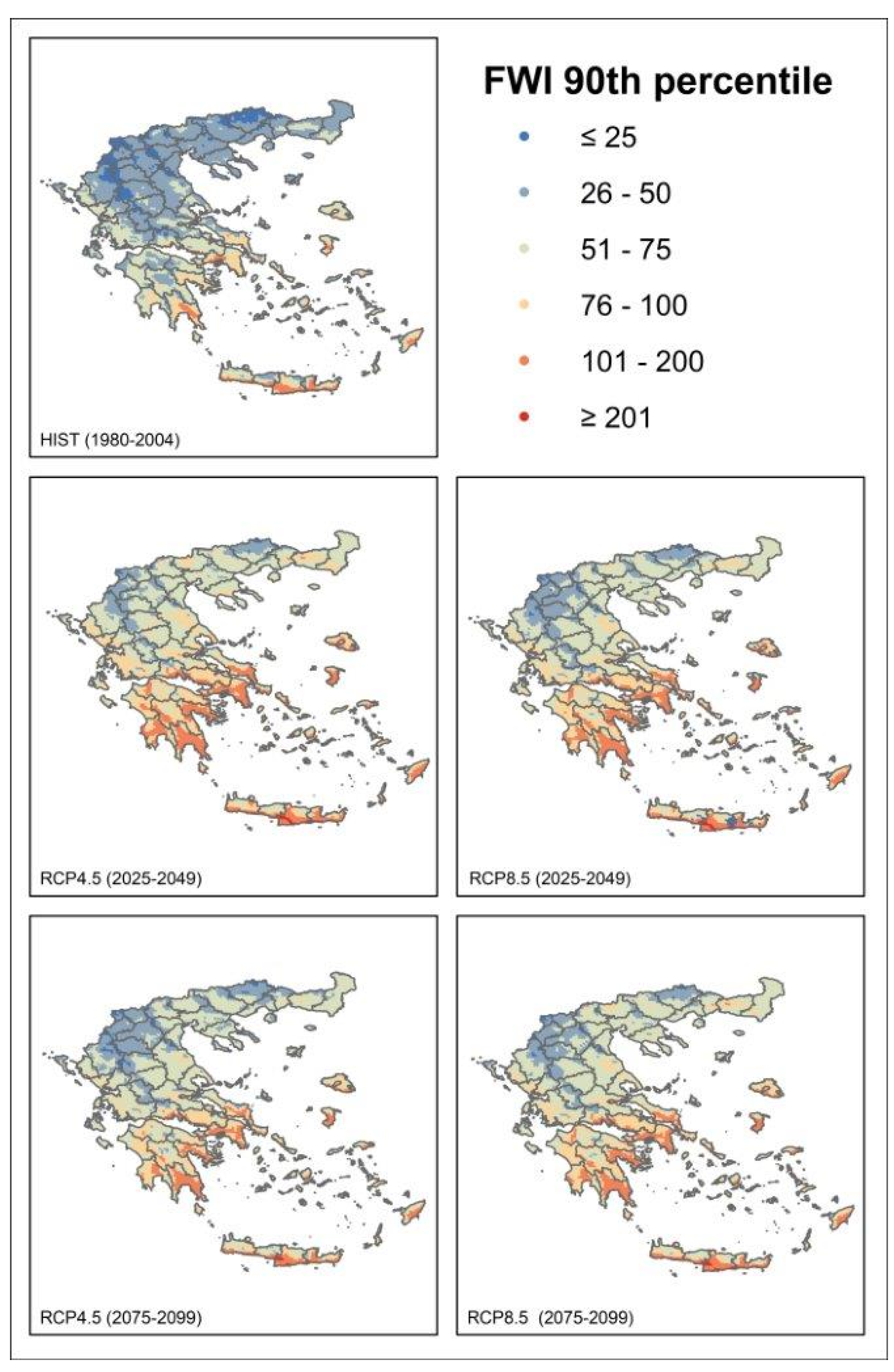
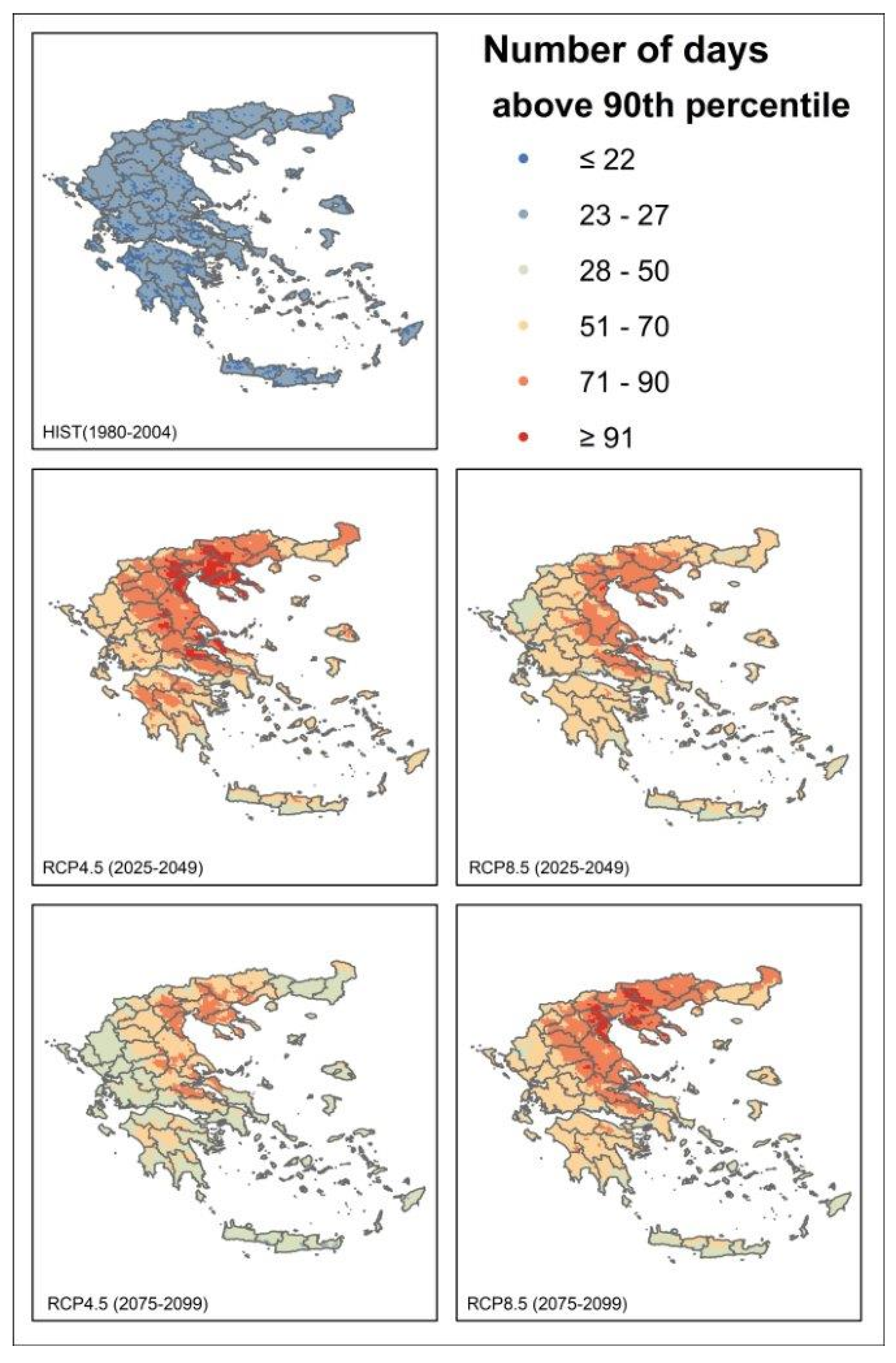
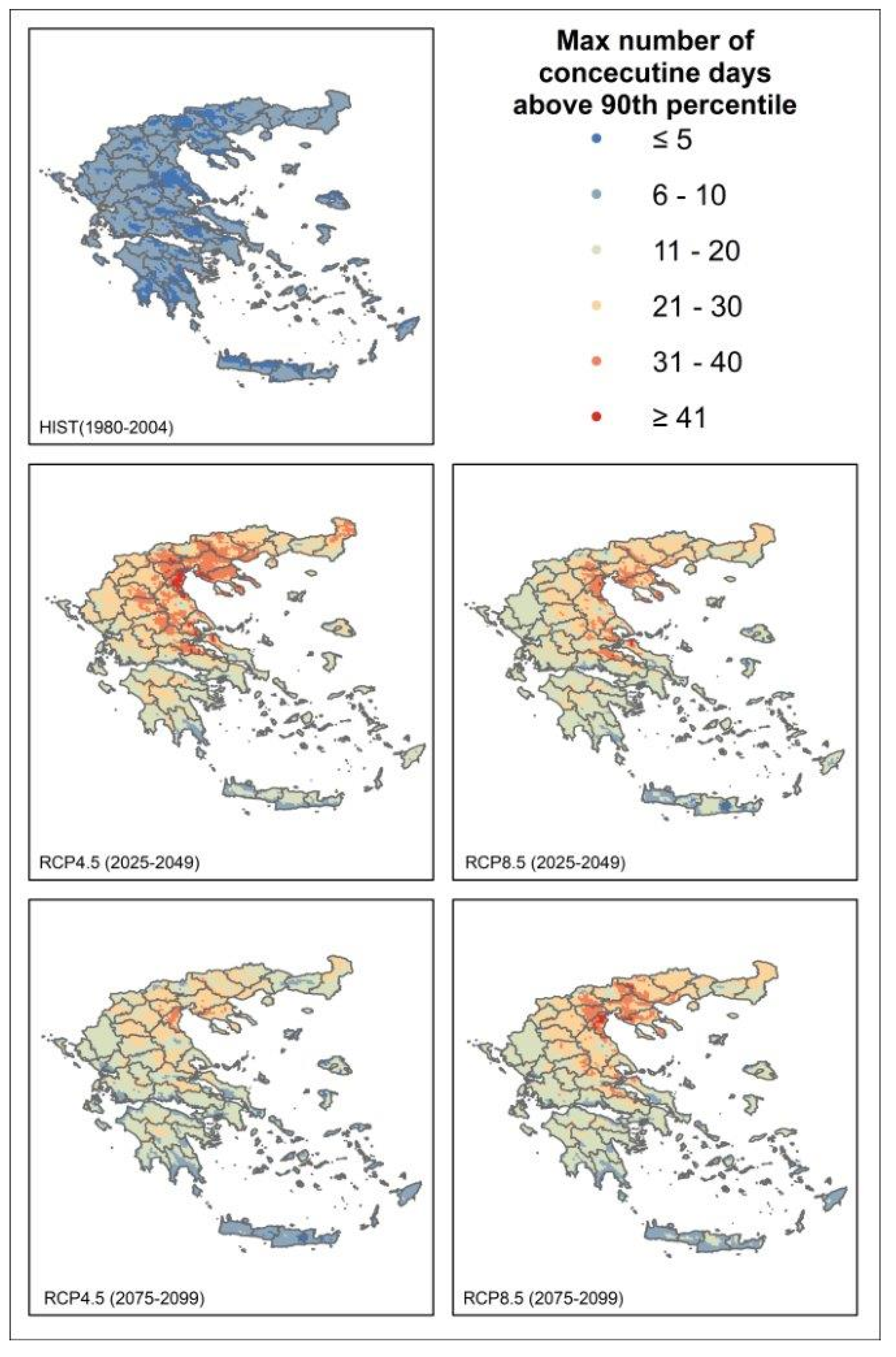
3.1. Fire Weather Index Projections

In this section, we present the spatially analyzed results of fire weather danger projections at the high spatial resolution of 5 × 5 km2 for the two emission scenarios RCP4.5 and RCP8.5 and for two time periods compared to the reference historical period.
Initially, Figure 2 depicts the values of the 90th percentile of the FWI in the historical and future periods. During the historical period, a north–south gradient is observed with lower values in northern parts (Thrace, Macedonia, Epirus and Thessaly) and higher values over Central Greece, the Aegean islands and Crete. These results are in accordance with previous related studies [14,29,30] that indicate that the drier and hotter southern and eastern regions of Greece seem to exhibit high values of the FWI.
The spatial pattern of the future values of the FWI is similar to the historical one, following the north–south gradient, but overall large increases are observed under the two emission scenarios all over the country. The highest increase is found in the Peloponnese, Central Greece, southern Crete, the Aegean islands and some parts of central Macedonia, particularly in the near-future period and under both scenarios.
For further assessment of wildfire danger, another indicator was compiled—that of the number of days above the 90th percentile threshold obtained for the reference period and investigated for future projections (Figure 3). It was concluded that in the historical period, no more than 30 days were found above the threshold value all over the country, with some exceptions occurring occasionally with values below 22 days. However, the projected results reveal that fire danger becomes more pronounced not only in the southern part of the country but also in eastern and northern Greece. The increase in the number of days is more evident in the near-future period under RCP4.5 and in the far-future period under RCP8.5 in the areas of central Macedonia, Thessaly, northern Central Greece, northern Evia, northern Crete and the Peloponnese. It is estimated that these areas will encounter more than 70 days of extreme fire weather during the fire seasons which corresponds to a future change of an increase of more than 45 days compared to the historical period. Moreover, in the future, almost the entire country is estimated to experience more than 30 extreme days compared to the historical period with a milder impact found under RCP4.5 in the far future. Similar findings have been reported in the study of Kapsomenakis et al., 2022 [58] where an analysis of threats from man-made climate change was carried out at 244 UNESCO cultural and natural heritage sites in the Mediterranean, using EURO-CORDEX simulations. The latter study showed over Greek areas higher differences in the number of days with FWI>45 compared to the historical period by the end of the twenty-first century under the RCP8.5 scenario than those of RCP4.5.
Furthermore, our results agree with the findings in the studies of Ntinopoulos et al., 2022 [29] and Rovinthakis et al., 2022 [30], where the future number of days exceeding thresholds compared to historic values increases under RCP 8.5, especially in the far-future period and over the eastern parts of Greece, central Macedonia and Thessaly. On the other hand, our results are quite different in what concerns the study of Karali et al., 2014 [25] where Attica, the Peloponnese and the northern Aegean islands exhibit the highest increases in the far future (but under the A1B emissions scenario). It should be mentioned that the latter studies use fixed FWI-threshold-exceeding days, those of above 45 or 30, and lower spatial resolution (from 12.5 km and above).
Similar results were reported in the study of Varela et al., 2019 [5] that evaluated fire danger and expected changes in the fire regime of a region in South France in the near future, where the affected by high FWI values (>50) area of more than one week in RCP4.5 would almost double compared to RCP8.5, using regional climate simulations of high spatial resolution (0.11°, ~12.5 km) from the EURO-CORDEX database.
An additional indicator calculated in this work is the consecutive number of extreme days above the 90th percentile to investigate the persisting extreme fire weather conditions in Greece. We categorized those days into a range of six classes, for visualization reasons, in order to define which areas are more affected by prolonged and extreme fire weather (Figure 4). It is obvious that the change in extreme consecutive days in the future is noticeable compared to the historical period. Areas in the eastern parts of the mainland and central Macedonia will experience longer fire weather conditions with more than 30 consecutive extreme days above the 90th percentile during all time periods and under both scenarios, compared to the southern parts (up to 20 consecutive days). Moreover, a more extended area will be affected by persisting extreme fire weather days in the near future under both RCPs and in the far future under RCP8.5.
In addition, we calculated the number of counts based on these six classes for each cell and each time period. Then, all counts were summed up for all grid cells per category and expressed in percent (%) to quantify each category for the entire country and examine how those would change in the future (Table 3). The results reveal that increases in the consecutive number of extreme fire weather days are projected under both emission scenarios. The most dominant category of less than 5 consecutive days corresponding to 95% of grid cells in the historical period reduces to values of circa 70% in the future as more cells, and hence areas, will experience a higher number of consecutive days (> 6 days). Thus, in the class of 6 to 10 consecutive extreme days, values of around 12-16% are found in the future, followed by smaller values of the remaining classes (>11 days) ranging approximately from 7 to 0.3%.

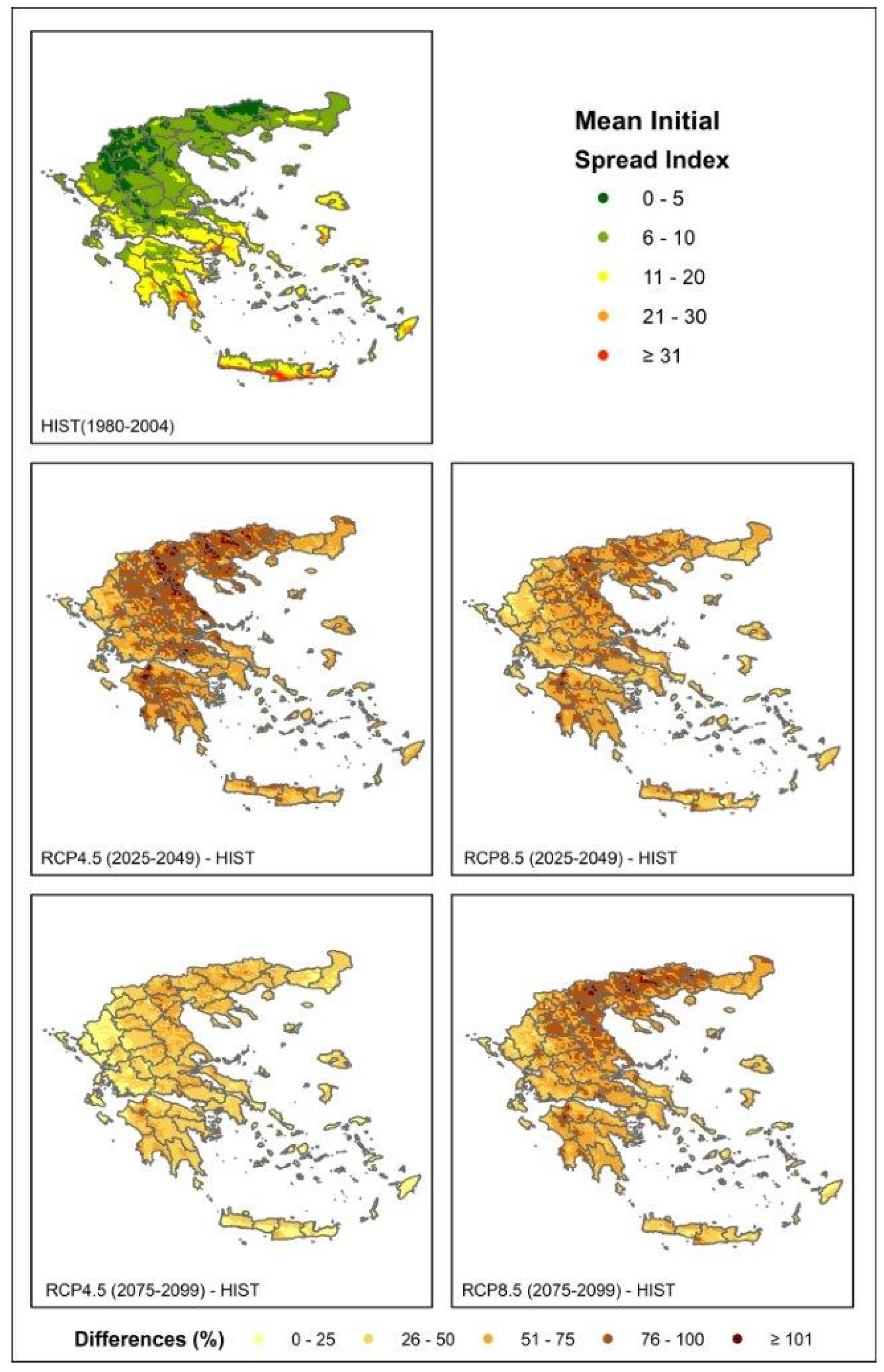
3.2. Initial Spread Index Projections

In this section, we present the results of future projections related to the mean Initial Spread Index (ISI), which combines the effects of wind and the Fine Fuel Moisture Code on the rate of spread (top map of Figure 5). ISI is a numeric rating of the expected rate of fire spread. The spatial distribution of the mean ISI for the historical period is illustrated in Figure 5, and it is divided into five classes. The lower values of the index are found in the central and northern mainland of the country, as well as in some parts of the Peloponnese, northern Crete and smaller islands. On the other hand, the highest values are observed in eastern Central Greece, along with some coastal parts of western mainland, Evia, the Peloponnese, Aegean islands and Crete.
To investigate the impact of climate change under the two scenarios on the ISI, we calculated the relative difference in percent (%) between the future and historical periods with respect to the historical period (Figure 5). The milder percentage differences are found in the far future and under RPC4.5 with changes up to 25% in western Greece, south-eastern Aegean islands and Crete. The results yield that in the near future and under RCP4.5, the ISI exhibits a robust increase of more than 75% in almost all parts of the country and even with a few areas of more than 100% change. Similar changes are also observed in the worst-case scenario of RCP8.5 in the far future but only for the central and northern mainland, while an increase in the range of 50 to 75% is noticeable in the rest of the country.
These findings concerning the near future are in accordance with the results of Varela et al., 2020 [57] where the mean values of the ISI were also found based on EURO-CORDEX data to increase in all areas under both scenarios. Moreover, the latter study indicated that higher increases were obtained for RCP4.5 compared to RCP8.5, particularly for most areas of the Natura 2000 network (including archaeological sites or sites of natural beauty with intense touristic load).
These results could be justified by the findings of Politi et al., 2022 [59], where the same data were used as in the current study, indicating that the probability of occurrence of extreme winds is higher almost all over the domain in the near future, under both scenarios, compared to the far-future period. Moreover, the increases in the ISI, calculated here, are in agreement with the results in the study of Katopodis et al., 2021 [54] where a notable enhancement of the mean wind speeds was found mainly over the north and central-western Aegean region, during the summer months under both RCP scenarios. In general, under climate change, the expected rate of fire spread is more spatially extended all over the country and particularly from southern to northern parts compared to the historical state.
The overall results derived from the analysis of the FWI, the ISI and the number of days threshold-based indices conform with the expected changes in temperature and precipitation, assessed in the latest studies [52,60]. Accordingly, seasonal precipitation changes, particularly during spring and summer will notably be decreased in the eastern and northern mainland in the near future under RCP4.5 and in the far future under RCP8.5. In addition, the most pronounced changes of up to 5 °C were found mostly over the eastern and northern mainland under RCP8.5 in the far future along with a general decrease in the annual precipitation, resulting in prolonged and severe drought conditions in the upcoming years that favor fire danger.

4. Conclusions

The present work investigated the future changes in fire weather danger conditions in the region of Greece at high resolution, under two future emissions scenarios (RCP4.5 and RCP8.5). The investigation focused on two future periods: (a) midcentury, 2025–2049 (near future), and (b) the end of the century, 2075–2099 (far future). The impact of climate change on fire danger was derived from the calculation of the daily Fire Weather Index (FWI) and Initial Spread Index (ISI) along with threshold-specific indicators, based on high-resolution WRF downscaled and evaluated climate datasets. The study revealed the most prone to wildfire danger areas of the country under a changing climate.
The use of high-spatial-resolution climate data with a combination of a novel approach to FWI classification established in this study provides a clear benefit to the derivation of fire danger patterns under a changing climate in Greece. Considering the complex topography of the country with a substantial diversity of environmental conditions, the current analysis aimed at overcoming certain limitations that arise from using fixed FWI thresholds which lead to systematic overestimation or underestimation of fire danger for certain regions detailed in Varela et al., 2018 [27]. More specifically, the applied method based on Percentile Indices provides suitably varying FWI boundaries of classes that take into account the specific physical characteristics of the study area at high resolution. To date, relevant studies for Greece using RCP emission scenarios are limited, and they have followed a fixed classification of the FWI values into fire danger levels [30]. An older study concerning Greece [25] has used three critical fire risk threshold values of the FWI employing previous generation emission scenarios (A1B and 25 km spatial resolution).
Overall, the results reveal a general increase in FWI 90th percentile values that is projected all over the country with the higher changes found in the areas of the Peloponnese, Central Greece, south Crete, Aegean islands and some parts of central Macedonia, particularly in the near-future period and under both scenarios. In addition, the projected number of days above the threshold revealed that the impact of fire danger will become more profound not only in the southern and eastern parts of the country but also in northern Greece. Central and northeastern parts of the country will be affected with 30 and more extreme consecutive days of prolonged fire weather, under RCP4.5, in the near future and under RCP8.5 in the far future.
Regarding the future projections of the ISI, remarkable changes are observed almost all over the country with 75% increases compared to the historical period and with even some areas presenting changes of more than 100% in the near-future period and under RCP4.5. We should always keep in mind that the number of fire events is not directly related to FWI values because fire events do not depend only on the meteorological conditions at the time of the event but also on the topography of the site, the vegetation conditions, wildland fuels and the suppression operations [61,62,63].
Future work pertaining to fire risk assessment taking into consideration climate change could elaborate on the application of extreme value analysis (EVA) with the calculation of return periods of the main relevant climate variables and the probability of occurrence above properly calculated thresholds or indices to establish fire weather conditions favoring extreme fire events. In addition, other future directions could focus on novel methodologies for the investigation of the fire exposure assessment related to fire parameters with direct effects of fire on people’s lives, properties, infrastructures and ecosystems. Future work planning also includes the assessment of the projected fire weather danger with the use of the new Shared Socioeconomic Pathway (SSP) scenarios of projected socioeconomic global climate changes up to 2100 derived from the latest CMIP6 simulations [64].
The high-resolution estimations obtained here may serve as reference work for future projections on fire weather danger due to climate change in Greece and may support the development of fire risk management policies to reduce the risk of wildfires and collateral losses. The results of the current study, in such high spatial resolution, could be used with auxiliary data, for example, on land use, population and vegetation for fire risk management and evacuation planning in areas prone and vulnerable to fire weather.

Author Contributions

Conceptualization, N.P. and D.V.; methodology, N.P. and A.S.; software, N.P.; validation, A.S.; formal analysis, N.P., D.V. and A.S.; investigation, N.P., D.V. and A.S.; resources, N.P.; data curation, N.P.; writing—original draft preparation, N.P.; writing—review and editing, D.V. and V.V.; visualization, N.G.; supervision, D.V.; project administration, A.S. All authors have read and agreed to the published version of the manuscript.

Funding

This research was partly funded by the European Union’s Horizon 2020 research and innovation program “FirEUrisk” grant number GA101003890.

Institutional Review Board Statement

Not applicable.

Informed Consent Statement

Not applicable.

Data Availability Statement

The data presented in this study are available on request from the corresponding author.

Acknowledgments

We kindly acknowledge Rita M. Cardoso and Pedro M. M. Soares from the Insituto Dom Luiz of University of Lisbon (Portugal) for providing EC-EARTH model input data and their guidance. This work was supported by computational time granted from the Greek Research and Technology Network (GRNET) in the National HPC facility, ARIS, under projects ID HRCOG (pr004020) and HRPOG (pr006028).

Conflicts of Interest

The authors declare no conflict of interest.

References

  1. Bowman, D.M.J.S.; Balch, J.K.; Artaxo, P.; Bond, W.J.; Carlson, J.M.; Cochrane, M.A.; D’Antonio, C.M.; DeFries, R.S.; Doyle, J.C.; Harrison, S.P.; et al. Fire in the Earth System. Science 2009, 324, 481–484. [Google Scholar] [CrossRef] [PubMed]
  2. Pausas, J.G.; Keeley, J.E. A Burning Story: The Role of Fire in the History of Life. Bioscience 2009, 59, 593–601. [Google Scholar] [CrossRef] [Green Version]
  3. IPCC; Pörtner, H.O.; Roberts, D.C.; Tignor, M.; Poloczanska, E.S.; Mintenbeck, K.; Alegría, A.; Craig, M.; Langsdorf, S.; Löschke, S.; et al. Summary for Policymakers: Climate Change 2022: Impacts, Adaptation, and Vulnerability. Contribution of Working Group II to the Sixth Assessment Report of the Intergovernmental Panel on Climate Change; Cambridge University Press: Cambridge, UK, 2022; ISBN 781009325844. [Google Scholar]
  4. Lozano, O.M.; Salis, M.; Ager, A.A.; Arca, B.; Alcasena, F.J.; Monteiro, A.T.; Finney, M.A.; del Giudice, L.; Scoccimarro, E.; Spano, D. Assessing Climate Change Impacts on Wildfire Exposure in Mediterranean Areas. Risk Anal. 2017, 37, 1898–1916. [Google Scholar] [CrossRef] [PubMed]
  5. Varela, V.; Vlachogiannis, D.; Sfetsos, A.; Karozis, S.; Politi, N.; Giroud, F. Projection of Forest Fire Danger Due to Climate Change in the French Mediterranean Region. Sustainability 2019, 11, 4284. [Google Scholar] [CrossRef] [Green Version]
  6. Peñuelas, J.; Sardans, J.; Filella, I.; Estiarte, M.; Llusià, J.; Ogaya, R.; Carnicer, J.; Bartrons, M.; Rivas-Ubach, A.; Grau, O.; et al. Impacts of Global Change on Mediterranean Forests and Their Services. Forests 2017, 8, 463. [Google Scholar] [CrossRef] [Green Version]
  7. EEA Climate Change, Impacts and Vulnerability in Europe 2016—European Environment Agency. Available online: https://www.eea.europa.eu/publications/climate-change-impacts-and-vulnerability-2016 (accessed on 22 November 2022).
  8. Ruffault, J.; Curt, T.; Moron, V.; Trigo, R.M.; Mouillot, F.; Koutsias, N.; Pimont, F.; Martin-StPaul, N.; Barbero, R.; Dupuy, J.-L.; et al. Increased Likelihood of Heat-Induced Large Wildfires in the Mediterranean Basin. Sci. Rep. 2020, 10, 13790. [Google Scholar] [CrossRef]
  9. European Commission; Joint Research Centre; Directorate-General for Environment; Institute for Environment and Sustainability; Libertà, G.; Schmuck, G.; San-Miguel-Ayanz, J.; Durrant, T.; Schulte, E.; Boca, R.; et al. Forest Fires in Europe, Middle East and North Africa 2012; Publications Office of the European Union: Luxembourg, 2013. [Google Scholar]
  10. European Commission; Joint Research Centre; Directorate-General for Environment; Institute for Environment and Sustainability; San-Miguel-Ayanz, J.; Rodrigues, D.; Libertà, G.; Schmuck, G.; Petroliagkis, T.; Boccacci, F.; et al. Forest Fires in Europe, Middle East and North Africa 2013; Publications Office of the European Union: Luxembourg, 2014. [Google Scholar]
  11. European Commission; Joint Research Centre; Directorate-General for Environment; Institute for Environment and Sustainability; San-Miguel-Ayanz, J.; Libertà, G.; Rodrigues, D.; Petroliagkis, T.; Schmuck, G.; Boccacci, F.; et al. Forest Fires in Europe, Middle East and North Africa 2014; Publications Office of the European Union: Luxembourg, 2015. [Google Scholar]
  12. European Commission; Directorate-General for Environment; Joint Research Centre; Libertà, G.; San-Miguel-Ayanz, J.; Durrant, T.; López Pérez, J.; Fires, F.; di Leo, M.; Schulte, E.; et al. Forest Fires in Europe, Middle East and North Africa 2015; Publications Office of the European Union: Luxembourg, 2016. [Google Scholar]
  13. European Commission; Joint Research Centre; Schulte, E.; Maianti, P.; Boca, R.; de Rigo, D.; Ferrari, D.; Durrant, T.; Loffler, P.; San-Miguel-Ayanz, J.; et al. Forest Fires in Europe, Middle East and North Africa 2016; Publications Office of the European Union: Luxembourg, 2017. [Google Scholar]
  14. Karali, A.; Varotsos, K.V.; Giannakopoulos, C.; Nastos, P.P.; Hatzaki, M. Seasonal Fire Danger Forecasts for Supporting Fire Prevention Management in an Eastern Mediterranean Environment: The Case Study of Attica, Greece. Nat. Hazards Earth Syst. Sci. 2022; preprint. [Google Scholar] [CrossRef]
  15. Costa, H.; Rigo, D.; Libertà, G.; Houston Durrant, T.; San-Miguel-Ayanz, J. European Wildfire Danger and Vulnerability in a Changing Climate: Towards Integrating Risk Dimensions: JRC PESETA IV Project: Task 9—Forest Fires; Publications Office of the European Union: Luxembourg, 2020. [Google Scholar]
  16. Steinfeld, D.; Peter, A.; Martius, O.; Brönnimann, S. Assessing the Performance of Various Fire Weather Indices for Wildfire Occurrence in Northern Switzerland. EGUsphere 2022, 2022, 1–23. [Google Scholar] [CrossRef]
  17. HNMS. Climatology, Hellenic National Meteorological Service. Available online: http://www.emy.gr/emy/en/climatology/climatology (accessed on 29 November 2022).
  18. Eftychidis, G. Mega-Fires in Greece (2007). In Encyclopedia of Natural Hazards; Bobrowsky, P.T., Ed.; Springer: Dordrecht, The Netherlands, 2013; pp. 664–671. ISBN 978-1-4020-4399-4. [Google Scholar]
  19. Copernicus Emergency Management Service|Copernicus EMS—Mapping. Available online: https://emergency.copernicus.eu/mapping/list-of-components/EMSR300 (accessed on 29 November 2022).
  20. Deadly Fire at Mati Still Haunts Greece Three Years Later. Available online: https://greekreporter.com/2021/07/23/deadly-wildfire-at-mati-still-haunts-greece-two-years-later/ (accessed on 29 November 2022).
  21. BBC News. Greece Wildfires: Evia Island Residents Forced to Evacuate—BBC News. Available online: https://www.bbc.com/news/world-europe-58141336 (accessed on 29 November 2022).
  22. Diakakis, M.; Xanthopoulos, G.; Gregos, L. Analysis of Forest Fire Fatalities in Greece: 1977–2013. Int. J. Wildland Fire 2016, 25, 797–809. [Google Scholar] [CrossRef]
  23. Dimitrakopoulos, A.P.; Mitsopoulos, I.D.; Gatoulas, K. Assessing Ignition Probability and Moisture of Extinction in a Mediterranean Grass Fuel. Int. J. Wildland Fire 2010, 19, 29–34. [Google Scholar] [CrossRef]
  24. Dimitrakopoulos, A.P.; Bemmerzouk, A.M.; Mitsopoulos, I.D. Evaluation of the Canadian Fire Weather Index System in an Eastern Mediterranean Environment. Meteorol. Appl. 2011, 18, 83–93. [Google Scholar] [CrossRef]
  25. Karali, A.; Hatzaki, M.; Giannakopoulos, C.; Roussos, A.; Xanthopoulos, G.; Tenentes, V. Sensitivity and Evaluation of Current Fire Risk and Future Projections Due to Climate Change: The Case Study of Greece. Nat. Hazards Earth Syst. Sci. 2014, 14, 143–153. [Google Scholar] [CrossRef] [Green Version]
  26. Kartsios, S. Study of Atmosphere-Wildland Fires Interactions, Using Numerical Models in Greece. Ph.D. Thesis, Aristotle University of Thessaloniki, Thessaloniki, Greece, 2020. [Google Scholar]
  27. Varela, V.; Sfetsos, A.; Vlachogiannis, D.; Gounaris, N. Fire Weather Index (FWI) Classification for Fire Danger Assessment Applied in Greece. Tethys J. Weather. Clim. West. Mediterr. 2018, 15, 31–40. [Google Scholar] [CrossRef]
  28. Psaroudakis, C.; Xanthopoulos, G.; Stavrakoudis, D.; Barnias, A.; Varela, V.; Gkotsis, I.; Karvouniari, A.; Agorgianitis, S.; Chasiotis, I.; Vlachogiannis, D.; et al. Development of an Early Warning and Incident Response System for the Protection of Visitors from Natural Hazards in Important Outdoor Sites in Greece. Sustainability 2021, 13, 5143. [Google Scholar] [CrossRef]
  29. Ntinopoulos, N.; Spiliotopoulos, M.; Vasiliades, L.; Mylopoulos, N. Contribution to the Study of Forest Fires in Semi-Arid Regions with the Use of Canadian Fire Weather Index Application in Greece. Climate 2022, 10, 143. [Google Scholar] [CrossRef]
  30. Rovithakis, A.; Grillakis, M.G.; Seiradakis, K.D.; Giannakopoulos, C.; Karali, A.; Field, R.; Lazaridis, M.; Voulgarakis, A. Future Climate Change Impact on Wildfire Danger over the Mediterranean: The Case of Greece. Environ. Res. Lett. 2022, 17, 045022. [Google Scholar] [CrossRef]
  31. Paschalidou, A.K.; Kassomenos, P.A. What Are the Most Fire-Dangerous Atmospheric Circulations in the Eastern-Mediterranean? Analysis of the Synoptic Wildfire Climatology. Sci. Total Environ. 2016, 539, 536–545. [Google Scholar] [CrossRef]
  32. Duane, A.; Brotons, L. Synoptic Weather Conditions and Changing Fire Regimes in a Mediterranean Environment. Agric. For. Meteorol. 2018, 253–254, 190–202. [Google Scholar] [CrossRef]
  33. Duane, A.; Piqué, M.; Castellnou, M.; Brotons, L. Predictive Modelling of Fire Occurrences from Different Fire Spread Patterns in Mediterranean Landscapes. Int. J. Wildland Fire 2015, 24, 407–418. [Google Scholar] [CrossRef]
  34. IPCC. AR5 Climate Change 2014: Impacts, Adaptation, and Vulnerability—IPCC. Available online: https://www.ipcc.ch/report/ar5/wg2/ (accessed on 11 May 2022).
  35. Van Vuuren, D.P.; Edmonds, J.; Kainuma, M.; Riahi, K.; Thomson, A.; Hibbard, K.; Hurtt, G.C.; Kram, T.; Krey, V.; Lamarque, J.-F.; et al. The Representative Concentration Pathways: An Overview. Clim. Chang. 2011, 109, 5. [Google Scholar] [CrossRef]
  36. Riahi, K.; Rao, S.; Krey, V.; Cho, C.; Chirkov, V.; Fischer, G.; Kindermann, G.; Nakicenovic, N.; Rafaj, P. RCP 8.5-A Scenario of Comparatively High Greenhouse Gas Emissions. Clim. Chang. 2011, 109, 33–57. [Google Scholar] [CrossRef] [Green Version]
  37. Mitsopoulos, I.; Mallinis, G. A Data-Driven Approach to Assess Large Fire Size Generation in Greece. Nat. Hazards 2017, 88, 1591–1607. [Google Scholar] [CrossRef]
  38. Skamarock, W.C.; Klemp, J.B.; Dudhia, J.; Gill, D.O.; Barker, D.M.; Wang, W.; Powers, J.G. A Description of the Advanced Research WRF Version 3 (No. NCAR/TN-475+STR); University Corporation for Atmospheric Research: Boulder, CO, USA, 2008; pp. 1–113. [Google Scholar] [CrossRef]
  39. Hazeleger, W.; Severijns, C.; Semmler, T.; Ştefǎnescu, S.; Yang, S.; Wang, X.; Wyser, K.; Dutra, E.; Baldasano, J.M.; Bintanja, R.; et al. EC-Earth: A Seamless Earth-System Prediction Approach in Action. Bull. Am. Meteorol. Soc. 2010, 91, 1357–1364. [Google Scholar] [CrossRef] [Green Version]
  40. Vautard, R.; Kadygrov, N.; Iles, C.; Boberg, F.; Buonomo, E.; Bülow, K.; Coppola, E.; Corre, L.; van Meijgaard, E.; Nogherotto, R.; et al. Evaluation of the Large EURO-CORDEX Regional Climate Model Ensemble. J. Geophys. Res. Atmos. 2021, 126, e2019JD032344. [Google Scholar] [CrossRef]
  41. Jacob, D.; Petersen, J.; Eggert, B.; Alias, A.; Christensen, O.B.; Bouwer, L.M.; Braun, A.; Colette, A.; D?qu?, M.; Georgievski, G.; et al. EURO-CORDEX: New High-Resolution Climate Change Projections for European Impact Research. Reg. Environ. Chang. 2014, 14, 563–578. [Google Scholar] [CrossRef]
  42. Prein, A.F.; Gobiet, A.; Truhetz, H.; Keuler, K.; Goergen, K.; Teichmann, C.; Fox Maule, C.; van Meijgaard, E.; Déqué, M.; Nikulin, G.; et al. Precipitation in the EURO-CORDEX 0.11◦ and 0.44◦ Simulations: High Resolution, High Benefits. Clim. Dyn. 2016, 46, 383–412. [Google Scholar] [CrossRef] [Green Version]
  43. Cardoso, R.M.; Soares, P.M.M.; Lima, D.C.A.; Miranda, P.M.A. Mean and Extreme Temperatures in a Warming Climate: EURO CORDEX and WRF Regional Climate High-Resolution Projections for Portugal. Clim. Dyn. 2019, 52, 129–157. [Google Scholar] [CrossRef]
  44. Soares, P.M.M.; Cardoso, R.M.; Lima, D.C.A.; Miranda, P.M.A. Future Precipitation in Portugal: High-Resolution Projections Using WRF Model and EURO-CORDEX Multi-Model Ensembles. Clim. Dyn. 2017, 49, 2503–2530. [Google Scholar] [CrossRef]
  45. Coppola, E.; Nogherotto, R.; Ciarlo’, J.M.; Giorgi, F.; van Meijgaard, E.; Kadygrov, N.; Iles, C.; Corre, L.; Sandstad, M.; Somot, S.; et al. Assessment of the European Climate Projections as Simulated by the Large EURO-CORDEX Regional and Global Climate Model Ensemble. J. Geophys. Res. Atmos. 2021, 126, e2019JD032356. [Google Scholar] [CrossRef]
  46. Hazeleger, W.; Wouters, B.; van Oldenborgh, G.J.; Corti, S.; Palmer, T.; Smith, D.; Dunstone, N.; Kröger, J.; Pohlmann, H.; von Storch, J.S. Predicting Multiyear North Atlantic Ocean Variability. J. Geophys. Res. Oceans 2013, 118, 1087–1098. [Google Scholar] [CrossRef] [Green Version]
  47. Hazeleger, W.; Wang, X.; Severijns, C.; Ştefănescu, S.; Bintanja, R.; Sterl, A.; Wyser, K.; Semmler, T.; Yang, S.; van den Hurk, B.; et al. EC-Earth V2.2: Description and Validation of a New Seamless Earth System Prediction Model. Clim. Dyn. 2012, 39, 2611–2629. [Google Scholar] [CrossRef]
  48. Politi, N.; Vlachogiannis, D.; Sfetsos, A.; Nastos, P.T. High-Resolution Dynamical Downscaling of ERA-Interim Temperature and Precipitation Using WRF Model for Greece. Clim. Dyn. 2021, 57, 799–825. [Google Scholar] [CrossRef]
  49. Politi, N.; Nastos, P.T.; Sfetsos, A.; Vlachogiannis, D.; Dalezios, N.R.; Gounaris, N.; Cardoso, M.R.; Soares, M.M.P.; Sfetsos, Á.A.; Vlachogiannis, Á.D.; et al. Comparison and Validation of WRF Model Physics Parameterizations Over the Domain of Greece. In Perspectives on Atmospheric Sciences; Springer: Cham, Switzerland, 2017; pp. 55–61. [Google Scholar]
  50. Politi, N.; Nastos, P.T.; Sfetsos, A.; Vlachogiannis, D.; Dalezios, N.R. Evaluation of the AWR-WRF Model Configuration at High Resolution over the Domain of Greece. Atmos. Res. 2018, 208, 229–245. [Google Scholar] [CrossRef]
  51. Politi, N.; Sfetsos, A.; Vlachogiannis, D.; Nastos, P.T.; Karozis, S. A Sensitivity Study of High-Resolution Climate Simulations for Greece. Climate 2020, 8, 44. [Google Scholar] [CrossRef] [Green Version]
  52. Politi, N.; Vlachogiannis, D.; Sfetsos, A.; Nastos, P.T. High Resolution Projections for Extreme Temperatures and Precipitation over Greece. Clim. Dyn. 2022. [Google Scholar] [CrossRef]
  53. Katopodis, T.; Markantonis, I.; Politi, N.; Vlachogiannis, D.; Sfetsos, A. High-Resolution Solar Climate Atlas for Greece under Climate Change Using the Weather Research and Forecasting (WRF) Model. Atmosphere 2020, 11, 761. [Google Scholar] [CrossRef]
  54. Katopodis, T.; Markantonis, I.; Vlachogiannis, D.; Politi, N.; Sfetsos, A. Assessing Climate Change Impacts on Wind Characteristics in Greece through High Resolution Regional Climate Modelling. Renew. Energy 2021, 179, 427–444. [Google Scholar] [CrossRef]
  55. Van Wagner, C.E.; Pickett, T.L. Equations and FORTRAN Program for the Canadian Forest Fire Weather Index System; Petawawa National Forestry Institute: Chalk River, ON, Canada, 1985. [Google Scholar]
  56. Casallas, A.; Jiménez-Saenz, C.; Torres, V.; Quirama-Aguilar, M.; Lizcano, A.; Lopez-Barrera, E.A.; Ferro, C.; Celis, N.; Arenas, R. Design of a Forest Fire Early Alert System through a Deep 3D-CNN Structure and a WRF-CNN Bias Correction. Sensors 2022, 22, 8790. [Google Scholar] [CrossRef]
  57. Varela, V.; Vlachogiannis, D.; Sfetsos, A.; Politi, N.; Karozis, S. Methodology for the Study of Near-Future Changes of Fire Weather Patterns with Emphasis on Archaeological and Protected Touristic Areas in Greece. Forests 2020, 11, 1168. [Google Scholar] [CrossRef]
  58. Kapsomenakis, J.; Douvis, C.; Poupkou, A.; Zerefos, S.; Solomos, S.; Stavraka, T.; Melis, N.S.; Kyriakidis, E.; Kremlis, G.; Zerefos, C. Climate Change Threats to Cultural and Natural Heritage UNESCO Sites in the Mediterranean. Environ. Dev. Sustain. 2022. [Google Scholar] [CrossRef]
  59. Vlachogiannis, D.; Sfetsos, A.; Markantonis, I.; Politi, N.; Karozis, S.; Gounaris, N. Quantifying the Occurrence of Multi-Hazards Due to Climate Change. Appl. Sci. 2022, 3, 1218. [Google Scholar] [CrossRef]
  60. Politi, N.; Vlachogiannis, D.; Sfetsos, A.; Nastos, P.T.; Dalezios, N.R. High Resolution Future Projections of Drought Characteristics in Greece Based on SPI and SPEI Indices. Atmosphere 2022, 13, 1468. [Google Scholar] [CrossRef]
  61. Werth, P.A.; Potter, B.E.; Alexander, M.E.; Cruz, M.G.; Clements, C.B.; Finney, M.A.; Forthofer, J.M.; Goodrick, S.L.; Hoffman, C.; Jolly, W.M.; et al. Synthesis of Knowledge of Extreme Fire Behavior: Volume 2 for Fire Behavior Specialists, Researchers, and Meteorologists; General Technical Report PNW-GTR—Forest Service (USA) Eng No. 891; Pacific Northwest Research Station: Portland, OR, USA, 2016. [Google Scholar] [CrossRef]
  62. Coop, J.D.; Parks, S.A.; Stevens-Rumann, C.S.; Ritter, S.M.; Hoffman, C.M. Extreme Fire Spread Events and Area Burned under Recent and Future Climate in the Western USA. Glob. Ecol. Biogeogr. 2022, 31, 1949–1959. [Google Scholar] [CrossRef]
  63. Abatzoglou, J.T.; Williams, A.P. Impact of Anthropogenic Climate Change on Wildfire across Western US Forests. Proc. Natl. Acad. Sci. USA 2016, 113, 11770–11775. [Google Scholar] [CrossRef] [PubMed] [Green Version]
  64. Eyring, V.; Bony, S.; Meehl, G.A.; Senior, C.A.; Stevens, B.; Stouffer, R.J.; Taylor, K.E. Overview of the Coupled Model Intercomparison Project Phase 6 (CMIP6) Experimental Design and Organization. Geosci. Model Dev. 2016, 9, 1937–1958. [Google Scholar] [CrossRef]
Figure 1. Left: Modeling domains: d01 refers to the outermost domain of 20 km and d02 to the nested domain of 5 km (region of Greece). Right: Location of areas discussed.
Sustainability 15 02498 g001
Figure 2. FWI threshold value of the 90th percentile in 5 × 5 km2 for the historical and future periods for each emission scenario.
Sustainability 15 02498 g002
Figure 3. The number of days above 90th percentile (threshold value is set as 90th percentile of the historical period for the specific cell for all time periods) for the historical and future emission scenarios in the near- and far-future periods.
Sustainability 15 02498 g003
Figure 4. The maximum number with consecutive days above 90th percentile (threshold value is 90th percentile of the historical period for the specific cell) for historical period and RCP4.5 and RCP8.5 for the near- and far-future periods.
Sustainability 15 02498 g004
Figure 5. The mean value of Initial Spread Index for the historical period (top map) and future changes under RCP4.5 and RCP8.5 (in %) for the near- and far-future periods with respect to the historical period (middle and bottom maps).
Sustainability 15 02498 g005
Table 1. Components of CFFWI System.
Components of CFFWI System
FFMCFine Fuel Moisture Code (FFMC) is a numeric rating of the moisture content of the smallest forest fuels (surface litter, leaves, needles and small twigs)
DMCDuff Moisture Code (DMC) represents the moisture content of loosely compacted, decomposing organic matter weighing about 5 kg/m2 when dry. It assesses fuel consumption in moderate duff layers and medium-size woody material at mid-afternoon
DCDrought Code (DC) indicates the moisture content of deep compact layer of organic matter weighing about 25 kg/m2 when dry
ISIInitial Spread Index (ISI) calculates the expected rate of fire spread and is the product of wind and fine fuel moisture functions
BUIBuildup Index (BUI) estimates the total amount of fuel available to the spreading fire by combining the DMC and the DC fuel moisture codes
FWIISI and BUI codes are used in the calculation of the Fire Weather Index. It is a measure of fire intensity in the form of energy output rate per unit length of fire front
Table 2. FWI classifications classed proposed by EFFIS and Varela et al. (2018).
Classification Proposed by EFFISPercentile Classification
Very low (<5.2)
Low (5.2–11.2)Low 25th percentiles
Moderate (11.2–21.3)Moderate 50th percentiles
High (21.3–38)High 75th percentiles
Very high (38–50)Extreme 90tth percentiles
Extreme (≥50)
Table 3. Total number of counts (sum) with consecutive days above the 90th percentile per category range for the total number of grid points, in percent (%), over 25-year periods.
Number of Total Counts per 25 Years (in %)
RCP4.5RCP8.5
ConsecDays HIST2025–20492075–20992025–20492075–2099
0–595.7471.8379.3072.9975.72
6–103.7216.4512.9015.9214.47
11–200.527.255.197.586.42
21–300.022.601.642.282.12
31–400.001.240.660.840.84
41+0.000.620.310.390.43
Disclaimer/Publisher’s Note: The statements, opinions and data contained in all publications are solely those of the individual author(s) and contributor(s) and not of MDPI and/or the editor(s). MDPI and/or the editor(s) disclaim responsibility for any injury to people or property resulting from any ideas, methods, instructions or products referred to in the content.

