
Small Hydroelectric Energy and Spatial Planning: A Methodology Introducing the Concept of Territorial Carrying Capacity


Faculty of Engineering, School of Spatial Planning and Development, Aristotle University of Thessaloniki, 54124 Thessaloniki, Greece
*
Author to whom correspondence should be addressed.
Sustainability 2023, 15(6), 5165; https://0-doi-org.brum.beds.ac.uk/10.3390/su15065165
Submission received: 22 December 2022
/
Revised: 18 February 2023
/
Accepted: 13 March 2023
/
Published: 14 March 2023
(This article belongs to the Special Issue Spatial Planning and Sustainable Energy Development)
Abstract
:The promotion of renewable energy sources (RESs) is a key European and national policy aimed at strengthening clean energy production, decoupling from fossil fuels, and responding to climate change commitments. Spatial planning is crucial as it can spatially direct the demand for investments in RESs, taking into account the challenges related to more efficient coexistence of RESs and environmental assets, both natural and manmade. Specific objectives, such as the definition of the carrying capacity concept, take on considerable importance in ensuring the balance between the demand for RESs and a number of other priorities. Small hydroelectric power stations (SHPSs), being spatially dependent on the existence of the natural resource (water), incorporate specific impacts in the areas of installation; namely, the watercourses. Taking into consideration the concept of carrying capacity for the areas where SHPSs are proposed to be installed by the Greek Special Spatial Planning Framework for RESs, which is limited to a linear/watercourse approach, this paper proposes a new complementary approach, that of “territorial” carrying capacity. The former involves the negotiation of terms and conditions for siting an SHPS within the narrow range of a water body (watercourse), while the latter, as proposed in this paper, attempts to capture the problem at the level of the wider territory or the functional area of a catchment, an approach that places carrying capacity in a more strategic spatial planning context.
1. Introduction
The use of renewable energy sources (RESs) is at the center of energy policy due to their key contribution to climate change mitigation, as well as their increasing significance for energy self-sufficiency. From these two perspectives, RESs play a vital role in overall sustainable development. The characteristics of renewable energy production, distribution, and consumption are central issues for spatial planning, as it seeks to organize territorial development according to the relationship between spatial characteristics and social, economic, and ecological requirements [1,2]. At the same time, spatial planning is a way of thinking and acting at various scales of space, time, and governance. It can thus contribute to the reduction or modification of uncertainties, such as those relating to the current energy crisis or the climate crisis [3,4].
A significant number of studies can be found in the relevant academic literature, which primarily emphasizes the spatial criteria for the optimal location of RESs. Optimal location issues for wind farms and photovoltaic parks have obviously attracted greater research interest [5,6,7]. This literature discusses significant topics regarding the set of location criteria used as critical inputs for spatial planning. However, research on the elaboration of specific tools regarding the links between allocation of renewables and spatial planning is still limited.
Energy—including RESs—is one of the major sectors of public policy. As a public sector policy, it is traditionally treated by many national planning systems more like a matter of a spatially relevant sectoral policy with impacts upon space and less as a direct spatial planning question. The “where-to-go” question for a single RES project can be easily answered, taking into consideration several spatial and environmental prerequisites. However, when it comes to clustering, more complicated issues are raised that necessitate strategic decision making to incorporate environmental impacts and socioeconomic costs and benefits in a broader way. Spatial planning channels the strategic approach in order to formulate and regulate territorial interventions from a more interdisciplinary perspective [8].
The scope and objectives of spatial planning and territorial governance are established in law, policy, and practice, with spatial plans being the key planning documents reflecting the objectives, policies, and intended outcomes of planning for the future of the specific areas [9,10]. Hence, spatial planning, either in its strategic dimension or in its more regulative form, is the tool used by central and local authorities to address specific policies, such as energy and climate change mitigation, at various spatial scales [9]. Energy production is of high importance. However, the spatial dispersion of energy installations should not just be a matter of effective production and distribution but also a matter of fitting the territorial characteristics. Thus, determination of the location of renewable energy installations and facilities should be planned by taking into consideration the need to minimize potential land-use conflicts, along with environmental preservation [2,11].
The role of spatial planning in climate change and energy policy can be proactive, regulatory, and coordinative [12]. A spatial plan for the development of RESs should operate as a proactive framework where negotiations and compromises can take place regarding seemingly conflicting goals (energy transition, social, and environmental goals) and interests, while at the same time providing transparent guidelines for the regulation of the spatial development of RESs. In this context, specific objectives, such as the concept of carrying capacity, become critical planning tools to secure the balance between the demand for renewables and the need to protect manmade and natural assets.
So-called mini or small hydroelectric energy (SHPS), in addition to being one of the basic forms of renewable energy, ensures a limited environmental impact even in sensitive environments and high-value landscapes [13]. SHPSs may be an attractive and sustainable way of producing power because of their potential to be installed in small rivers and streams [14]. Being spatially dependent on the existence of the natural resource (water), SHPSs usually incorporate specific and relatively distinct potential impacts on their surrounding areas and, especially, on the function of the watercourses. Some of these are related to the hydromorphological alterations to the hydrography and their impact on its ecological status. Studies concerning spatial criteria for the development of SHPSs are rather limited [13].
In order to cope with such concerns, the Greek Special Spatial Framework for RESs (SPF-RES), enacted in 2008 and currently under revision [15], incorporates the concept of carrying capacity as a stream-based issue—i.e., based on a “linear” approach—by examining the number of possible SHPSs per specific watercourse, taking into consideration its functional and ecological integrity. Without questioning the importance of this linear approach, the current paper aims to expand the carrying capacity rationale towards a more territorial-based approach. In this approach, the concept of carrying capacity refers to the availability of the resource—i.e., the water potential—combined with water policy priorities that focus on the pursuit of their good ecological status. The need to assess the capacity of a given area (i.e., the catchment or watershed of a river basin) for SHPSs initially originated from the guidance of the Water Framework Directive 2000/60/EC [16] regarding control of hydromorphological pressures on surface water bodies. Accumulation of SHPSs may affect the ecological status of a catchment’s main river body and have negative effects on human activities or the ecosystem itself. Therefore, their installation should become a matter of spatial planning and regulation, as this paper suggests.
The remainder of the paper is structured as follows: Section 2 initially briefly addresses the types of potential impacts resulting from the installation and operation of SHPSs. It then discusses the limitations of the currently applied concept of linear carrying capacity, as suggested by the SPF-RES, and proceeds with some key comments on the literature regarding SHPS capacity assessment. Section 3 and Section 4 focus on the development of two methodologies for the determination of the concept of territorial carrying capacity and their respective results. Section 5 discusses the advantages and limitations of these two methodologies and their implications for spatial planning.
2. Potential Impacts of SHPSs and the Limitations of Existing Approaches to Carrying Capacity Assessment
2.1. Main Features of SHPSs and Their Potential Impacts
In principle, the operation of an SHPS is based on the utilization of the potential energy of the surface waters. An SHPS takes advantage of the natural fall of water and the difference in altitude through a pressurized hydraulic system that channels the water into a turbine. The main technical features that make up a typical SHPS are the water abstraction system, the intake pipeline, and the generating station [17]. According to the definitions of the SPF-RES [15] of the Greek spatial planning system, small hydroelectric plants are those plants with an installed capacity that does not exceed 15 MW. Impacts on the environment concern both the construction and the operational phases and relate to changes in the geomorphology, hydrography, and landscape; alteration to riparian habitats; impacts on fish mobility; etc. [18] (pp. 11–14). One of the objectives of the Water Framework Directive 2000/60/EC [16] is to achieve good ecological status for surface water bodies, such as watercourses, in response to the pressures exerted by various human activities. These include significant hydromorphological alterations. A European Commission guidance document on the requirements for hydropower in relation to nature legislation [19] details the potential impacts of hydropower projects on installation watercourses. Among other things, specific reference is made to impacts related to the morphology of rivers and the ecological status of their flow. The critical importance of maintaining the ecological flow (flow rate) is also noted, as it is a mechanism vital for ensuring the ecological status of water bodies.
In the water management plans for Greece’s river basins (first revision) [20], the preservation of the ecological flow of surface water bodies (rivers, streams) is required, on the one hand, for the protection of their ecological role and, on the other hand, for the sustainability of water-using activities (such as hydroelectric power plants) in light of the potential risks of climate change. According to a methodology document published by the Greek Special Secretariat for Water [21], the concept of hydromorphological alteration refers to a change that occurs in a watercourse in a way that affects and reshapes its morphological and hydrological conditions. Hydromorphological alterations are related to the geometry of watercourses, which also affects the composition of the habitats on their banks.
Among the multiple factors that contribute to the creation of hydromorphological alterations in watercourses is the category “barriers/transverse structures/regulation projects” [21]. This category includes the water intake works of SHPSs, as they are usually structures that are low in height. SHPSs do not permanently remove water from a watercourse but rather return it after a bypass of relatively short length. What they do create, however, is a change in the mobility conditions of the fish, which, therefore, constitutes a hydromorphological pressure. In fact, the length of the water diversion for the operation of a small hydropower plant is the key indicator for understanding the degree of pressure exerted by these installations and, therefore, for assessing the hydromorphological alterations they may cause, and not the installed power capacity. During the operation of an SHPS, in the diversion section and within the watercourse, only the ecological flow usually remains.
For the Greek territory, the resulting pressure is considered high, as the generally short-term significant winter flows cannot be fully exploited by SHPSs for various technical reasons, resulting in the water potential being used over a long-time span within the year and leaving the watercourse with only the ecological flow.
In general, the concept of ecological flow refers to the minimum flow that a watercourse must have in order not to affect the ecosystem downstream of an intervention that may disturb its flow (water abstraction, diversion, etc.). Further clarifications of the notion of ecological flow link it not only to hydrological parameters but also to the morphological and structural characteristics of the bed and riparian zone of a watercourse, which must be taken into account in order to maintain its good ecological status [22].
2.2. Main Limitations of the SPF-RES Approach to Carrying Capacity
The current SPF-RES was approved in 2008 [15] and its main goal is the formulation of policy guidelines and regulations for the siting of RES projects in order to meet the objectives of national and European policies.
For the category of SHPSs, the SPF-RES (Article 12) sets a series of spatial planning objectives to secure the sustainable spatial development of the sector. Among other priorities, it aims to define carrying capacity criteria based mainly on the geographical level of a watercourse.
The SPF-RES states that, until the criteria for the minimum required ecological flow per river basin are established, the minimum required ecological flow remaining in the natural watercourse bed immediately downstream of the water abstraction project of a planned SHPS should meet certain ad hoc values throughout the national territory. In a Ministerial Decision of 2011 [23] that followed, another condition was added according to which the ecological flow should also secure a minimum water depth in the diversion section if this is the permanent habitat for fish.
The abovementioned context largely accepts that the main impact of SHPS installation and operation lies in the hydromorphological alterations that occur in the hosting waterbody, which may affect its ecology, even when considered broadly. The main method of dealing with this impact is the use of certain technical terms for securing ecological flow. At the level of national water policy, the recognition and treatment of this impact are linked to the management objective of maintaining the good ecological status of river systems. In response to these objectives, the statutory spatial planning for regulating SHPS development introduced the concept of carrying capacity. Hence, the carrying capacity of the receptors (watercourses) is understood as the maximum potential for installation (i.e., the density of installations) of SHPSs in the same “line” of hydropotential; i.e., in the same watercourse. The carrying capacity of the receptors of SHPSs aims to ensure their coexistence with other uses served by the same receptor; in particular, water supply, economic activities, and the ecosystem.
Regarding the optimal siting of SHPSs according to the statutory guidelines, the following points can be highlighted:
- The placement of one or more SHPSs in series on a particular watercourse should take into account: (a) the existence of exploitable water flow; (b) the limitations—the carrying capacity assessment of the watercourse in question; and (c) the ecological provisions for other water uses or ecosystem functions;
- The assessment of carrying capacity applies to each watercourse separately and individually. The approach is linear and functions per watercourse branch rather than being extensive; i.e., per administrative or management (e.g., catchment) area;
- The current methodology for linear carrying capacity assessment attempts to address the issues of siting individual SHPSs in the context of their licensing;
- The current methodology, however, does not address issues regarding potential pressures on broad development zones due to the accumulation of relevant investment activity.
Therefore, the determination of the carrying capacity for the installation of an SHPS is essentially linear in nature, aiming to resolve the spatial issue locally and individually within the territorial range of a watercourse. It does not attempt to address issues of a strategic nature, as these are shaped by national and European water policy, which aims to promote the good ecological status of river bodies through the control of hydromorphological alterations. This entails a situation with a potential impact; that is to say, one shaped by the synthetic and cumulative effects in the area of the investment interest. As a response to these weaknesses, a new approach is developed in this paper based on the assessment of surficial/catchment area carrying capacity that is complementary to the linear approach.
2.3. SHPS Capacity Assessment in the Relevant Literature
There are a certain amount of studies on the carrying capacity of small hydroelectric power plants that mainly focus on the criteria selected for the best siting of a single plant in a relatively small geographical area. In these research approaches, the capacity is measured in installed power units (e.g., watts) per territorial units (e.g., sq. km), taking into consideration a variety of factors that influence and shape the location decision, such as technical, economic, environmental, and social aspects. The methods used include assessments of hydrology and topography, economic feasibility, ecological impact, social acceptance, and technological integration. The systematization of the above is mainly undertaken through the development of GIS-based processing tools and other calculation routines [24,25,26].
These analytical methods do not actually raise the spatial planning question at the large scale of the national/regional territory but rather provide criteria for the most effective siting of such projects at the watershed level. As such, they can prove to be valuable in decision making regarding SHPS siting in relatively small areas when searching for alternatives and aiming to ensure sustainability. However, these approaches do not deal with the strategic questions of planning SHPS development in broad geographical areas, such as: (a) which areas are originally favorable for the hosting of SHPS investment; (b) what other strategic policies can be used as inputs to refine the planning question; and (c) how territorial capacity in large areas is understood and how can it be measured.
Taking into consideration the case of the Greek statutory spatial planning framework, the above questions are essential in guiding the development of SHPSs. The hydraulic availability in certain regions, for example, could lead to high accumulations of plants in relatively large areas, a prospect that could raise other preservation concerns, such as the ecological status of their associated rivers. This core working hypothesis leads to an approach that provides a valid methodological context making it possible to initially designate areas for further development of SHPSs and areas where possible development could incorporate additional restrictions. This approach should operate at a preliminary stage in planning and decision making without substituting the analytical examination for site selection.
3. Methodology
For the purpose of the study, the data for the SHPS projects derived from the open geospatial database of the Greek Regulatory Authority for Energy [27] were retrieved on 12 October 2020. Data were processed and categorized into two groups: (a) existing SHPS plants (with an operation license or in the final stage of being installed after the completion of all permits); and (b) future projects in the process of being licensed, excluding rejected projects.
Existing plants and projects in development were recorded as an indication of investment interest and, in general, territorial demand for SHPS installation. The assessment of the “territorial” carrying capacity proposed in this paper seeks to contribute to a more comprehensive spatial planning approach for SHPS development by incorporating the provisions of the water policy into the decision-making process; specifically, handling the control of hydromorphological alterations as part of the overall objective of maintaining the good ecological status of river bodies. However, the question of the territorial reference range still remains. In other words, what is the test area that should be taken into account in the operational application of methods for calculating territorial carrying capacity? In this context, two methods can be considered: the territorial density-based method and the catchment-based method.
The first method refers to a general and horizontal approach of calculating the possible installation capacity for SHPSs in units per km2 across the whole national territory or, better, across the part of it that bears the appropriate conditions for supporting the activity (e.g., mountainous areas and not islands) and is referred to here as the territorial density-based method. As a first step, this method takes into consideration: (a) the hydrographic potential available for the installation of SHPSs according to legal restrictions and (b) the maximum number of plants per watercourse according to the linear capacity.
These inputs are processed in a GIS environment and result in a weighted set for the hydrography network that expresses the most-to-least favorable streams for the installation of SHPSs, assuming that ecological flow is secure in all cases. Spatial interpolation of this linear set (with cell size according to the minimum distance between plants defined by the law) produces a surface with a value per cell: the potential territorial density. The latter reflects the number of plants that could be installed per km2 throughout the selected national territory. Then, spatial interpolation is applied to the point datasets of the existing and future SHPS plants, resulting in two surface datasets: (a) the current accumulation of plants and (b) the future accumulation if the entire investment interest materializes (including the existing plants). Both surface datasets express the accumulation of plants per km2 in the same cell size for the latter calculation step. Overlaying the above datasets, comparisons can be performed, and planning decisions can be adjusted accordingly. In this case, decisions may take into consideration broad areas where the accumulation is likely to exhaust the carrying capacity and apply further restrictions. Figure 1 presents the conceptual flowchart for the first method.
The second method, which is referred to as “catchment-based”, utilizes the territorial reference of a catchment as the critical spatial management unit for the maintenance of the good ecological status of the hydrography in accordance with the objectives of water policy. This method approaches the concept of carrying capacity in an indirect, more qualitative way. Using the GIS environment, this method applies a simple overlay analysis of the SHPSs (existing and future). Point datasets are overlaid on (a) the polygon datasets of the catchment areas derived from the Regional Watershed Management Plans and (b) the associated watercourses (line datasets) categorized in terms of their ecological status according to these plans (high, superior to good, good, moderate, deficient, and poor ecological status). Accumulation of plants (existing and/or future) in catchment areas where the downstream main river body is categorized in terms of its ecological status as “worse than good” could trigger planning to initiate decisions accordingly; in other words, to initiate specific policies to either ban any further development or set additional terms for any new development based on qualitative criteria. Figure 2 presents the conceptual flowchart for the second method.
4. Implementation and Results
4.1. The Territorial Density-Based Approach to Carrying Capacity
As a result of the application of the first method, Figure 3 illustrates the number of SHPSs that could be installed per km2 throughout the selected national territory (mainly mountains and semi-mountainous areas with hydraulic potential). These areas are not related directly to the altitude but defined according to the extent of the mountainous river basins in order to better correlate with the potential hydrodynamic. Plains, islands, and vast urban areas were excluded. Watercourses included in the model were those inside the area defined above. Watercourses with lengths shorter than those appropriate for possibly hosting an SHPS were, in accordance with the criteria set by law, excluded. Each of the remaining watercourses was assigned a value according to the number of plants it could support through the application of the official linear capacity methodology (one, two, three, and so on). Spatial interpolation was applied, and a surface dataset was created that showed the potential number of plants per km2. According to the resulting surface, the territorial density of allowed SHPS installations was between 0 and 2.24 per km2 of surface area.
According to the official geospatial data for existing SHPSs, there are 157 installations, which are located mainly in the Pindus range, in the mountains between Central and Western Macedonia, in the Rodopi range, and in the northern Peloponnese region. Other accumulations of lesser intensity or of individual interest seemed to be scattered across various regions of the country. Using interpolation routines, these 157 SHPS were employed to determine the density surface (limited to the mountainous and semi-mountainous areas accepted as favorable), with values between 0 and 0.02 plants per km2 (Figure 4). Overlaying this surface upon the one created earlier in order to assess the potential capacity, it was estimated that the existing accumulation raises no actual concerns about its exhaustion.
This task was repeated using the geospatial database of new investment interests for SHPS projects plus the existing ones in order to assess the future spatial accumulation trend and, therefore, the resulting territorial density. The Pindus range then seemed to emerge as a homogeneous zone with a high accumulation pattern, the core of the northern Peloponnese region expanded further south, the core of the Rodopi range was also strengthened, and new areas of interest emerged across the country, except for in the islands. There were 492 SHPS installations recorded (planned and existing), which created a density surface of between 0 and 0.06 plants per km2 (Figure 5). The comparison with the surface potential capacity showed that the new accumulation should hardly raise any concerns, despite the significant increase in interest in installing.
The comparison of the density values for the actual and planned SHPS accumulations, on the one hand, and the potential capacity, on the other, yielded measurable conclusions and can provide an assessment context for the potential space available to accommodate these facilities. This potential incorporates the carrying capacity in territorial terms and may trigger decision making if used as an analytical tool in the spatial planning process. The question intended to be answered was how many SHPSs could be sited at any given location within the predefined favorable areas for such activities such that the spatial system could endure. The proposed methodology indeed needs further development, as described in the next section. Nonetheless, it can direct thinking toward an approach that has attracted little attention so far.
4.2. The Catchment-Based Approach to Carrying Capacity
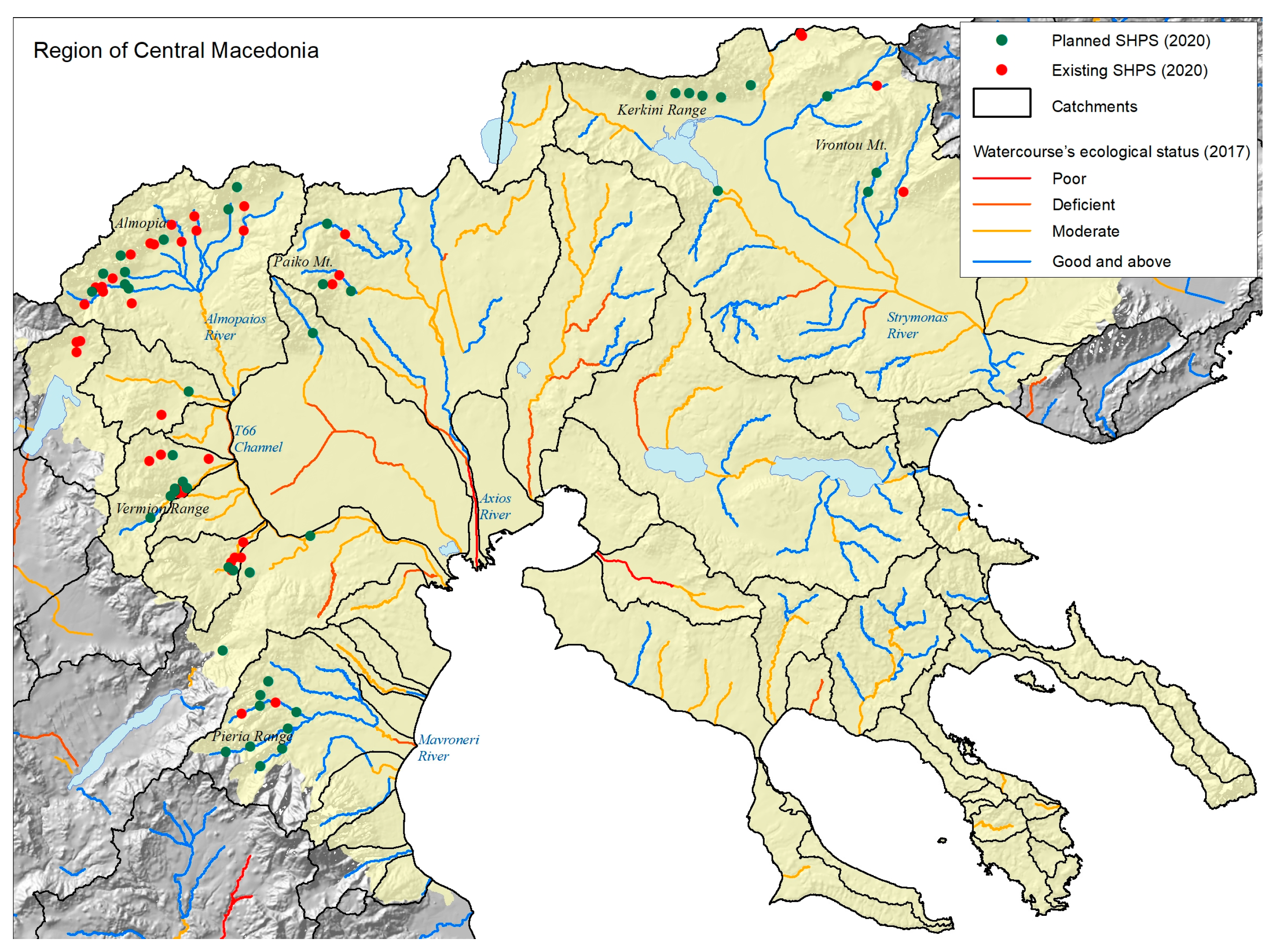
For the implementation of the second method, the region of Central Macedonia, in the north of the country, was selected as a case study. This region has traditionally attracted significant interest for the installation of SHPSs. According to the geospatial data from the Regulatory Authority for Energy [24] (data from December 2000):
- Forty-one existing plants can be counted in two main clusters: in the mountainous area of Almopia and in the Vermion range. Smaller clusters are also located in the mountains of Pieria, Paiko, and Vrontou;
- Forty-seven new projects are on the way to being approved, expanding the existing clusters while also forming new accumulations (Kerkini range);
- In total, 88 installations create the forthcoming investment landscape for the region in the abovementioned areas of interest.
The second method, which is referred to as “catchment-based”, utilizes the territorial reference of a catchment as the critical spatial management unit for the maintenance of the good ecological status of the hydrography in accordance with the objectives of water policy. This method approaches the concept of carrying capacity in an indirect, more qualitative way. Using a GIS environment, this method applies a simple overlay analysis of the SHPS plants (existing and future). Point datasets are overlaid on: a) the polygon datasets of the catchment areas derived from Regional Watershed Management Plans and b) the associated watercourses (line datasets) categorized in terms of their ecological status according to these plans (high, superior to good, good, moderate, deficient, and poor ecological status). Accumulation of plants (existing and/or future) in catchment areas where the downstream main river body is categorized in terms of its ecological status as “worse than good” could trigger planning to initiate decisions accordingly; either to ban any further development or to set additional terms for any new development, a rather political way of arranging things in space.
From the graphical overlapping of the abovementioned datasets (Figure 6), some general assessments can be made as follows:
- The only SHPS cluster that can be connected to a watercourse with a poor ecological status (the lower Axios River) is that of Paiko Mountain. The SHPS accumulation in this area lies within catchments that are part of this river’s basin;
- The only SHPS cluster that can be connected to a watercourse with a deficient ecological status (the Mavroneri River) is that of the Pieria Range. The SHPS accumulation in this area lies within catchments that are part of this river’s basin;
- All other SHPS clusters are connected to watercourses with moderate ecological statuses (Almopaios River, T66 Channel, Strymonas River). These accumulations lie within catchments that are part of their river basins.
The ecological status of a watercourse is related to a variety of potential hydromorphological alterations along its course. Stresses produced by activities along the banks or across the catchment areas trigger such alterations. Installations of SHPSs are considered to be one of these factors. However, since this is not the only cause, its relative impact should be a matter of further analysis. In any case, clustering could become a matter of further concern, as the findings above show. Although qualitative, decision making could utilize such findings in order to come up with terms for reshaping planning; terms, for example, that could aim at the capacity of a catchment area to receive new SHPS investment within the scope of at least maintaining its current ecological status (catchment-based carrying capacity).
Keeping in mind the findings described so far, a possible set of planning directions aimed at preserving the capacity of catchment areas in order to ensure their associated watercourses are not degraded ecologically could be as follows:
- Within catchment sub-basins where the associated main river body has a poor or deficient ecological status, the further increase in hydromorphological stresses should be a matter of additional concern. SHPS accumulation, as one of these pressures, should be subject to additional restrictions. Water deviation shorter than the permitted length or, more drastically, the banning of new installations could be on the table;
- Within catchments where the associated main river body has a moderate ecological status, the further increase in hydromorphological stresses should be a matter of monitoring, though not of immediate concern. Possible restrictions on the further development of SHPSs could focus on the permitted water deviation length rather than anything else, at least in the short term;
- Within catchments where the associated main river body has an ecological status of good or above, no actual concerns should arise, at least in the medium term.
The assumption underlying such planning alternatives is that the carrying capacity of a catchment area, in terms of the ecological status of the main river body, tends to be reached due to increases in its hydromorphological stresses. Being part of such stresses, SHPS accumulation planning should consider the situation and adjust. This approach provides an indirect and qualitative way of assessing carrying capacity in space as defined by its systemic characteristics rather than administrative boundaries.
4.3. A Comparison of the Key Features of the Methodological Approaches
As stated earlier, the proposed analysis aimed to supplement the official methodology for SHPS sitting along a watercourse and not replace it, taking into consideration that the linear approach cannot properly provide a coherent strategic framework to spatially guide investment demand. Both the linear and the territorial considerations can be useful in decision making. However, they focus on different spatial scales, and thus they serve different planning objectives. Table 1 comparatively summarizes the key features of the linear approach and the two proposed methods for the territorial approach.
5. Discussion and Conclusions
The aim of this study was to extend the concept of carrying capacity as used in the siting of SHPS installations from the strictly linear level (the one proposed institutionally by the SPF-RES) to the territorial level by proposing two methodological approaches. The first treats space as a single entity, considers hydraulic availability and other constraints, and assigns a geospatial model (through interpolation) that expresses the siting potential per km2 of the respective surface area. Surface values for SHPS accumulation per km2 that exceed the theoretically calculated ones indicate that the potential carrying capacity will be exceeded. The second approach, which is spatially focused, evaluates conditions in the systemic area of catchments and yields qualitative results. Clusters of SHPSs with a tendency to expand in catchments where the associated main river body is categorized with an ecological status less than good could raise concerns about the possibility of carrying capacity being exceeded. This is an indirect way of assessing capacity by inserting the hydromorphological stresses of the catchment areas into the assessment context.
The territorial carrying capacity approach, as an operational decision-making tool, enables a response to the objectives of the water policy either directly or indirectly. Both of the methods proposed here are based on a concern for the preservation of the good ecological status of watercourses through the control of their hydromorphological alterations. The aim was to assess the impacts of SHPS accumulation and, through that, to enhance legislation with possible new siting terms.
The first methodological approach provides quantitative results. The main advantage is that it provides a homogenized and stable way to assess capacity in vast areas, such as the national territory or regions of it, that are predefined as favorable to receive SHPS investments. Operationally, it can be used as a “yes/no” switch regarding the possibility of an SHPS being installed. In order to become reliable, however, it needs the development of large databases with all the essential information tested and updated, which would require committed dedication from the authorities. For example, essential inputs would include detailed and accurate geospatial layers depicting the elevation, the stream network and its temporal water flows; determination of the ecological flow; constraints and restrictions from legislation; and so on.
The second methodological approach provides qualitative results. The main advantage concerns the (mainly indirect) correlation of the territorial capacity concept with the ecological function of the watercourses and their respective catchments. The need for the ecological preservation of streams and catchment areas is well-defined in the water policy, as well as the factors that produce stress. Operationally, it facilitates decision making by setting additional criteria for planning and licensing procedures. Inputs are usually datasets, officially available with few processing demands. In order to increase reliability, however, the contribution of the installation of an SHPS to the degree of disturbance of the ecological status of watercourses should first be well-defined, since these installations are not the only factors that impose stresses on their adjusted catchments.
The main limitation of the statutory linear capacity method is that it constitutes an operational tool designed to guide siting for an individual watercourse and, as such, it cannot provide answers to the question of whether to encourage the accumulation of plants in certain areas or not. Since this question is a typical issue in planning, the two proposed methods aim precisely at supplying a toolbox with ideas that focus on the concept of territorial (carrying) capacity for this matter. However, they also have limitations and need further refinement in order to become fully operational.
The main limitation of the territorial density-based approach lies in the need for detailed systematization of its model parameters, a task that is highly demanding in terms of resources, along with extensive testing before application in practice. As an operational tool, it can be used for making planning decisions at a preliminary stage and designating areas for further SHPS development but not as a siting tool. The main limitation of the catchment-based approach lies in the need to properly internalize a series of other factors that create hydromorphological alterations to the watercourses, a task that is highly demanding in base studies, in order for the model to come up with valid assessment results. As an operational tool, it is rather difficult to answer the question of whether new plants could be installed in a given watershed rather than enriching the planning context with additional terms regarding the siting of possible new SPHSs.
In conclusion, both methodological approaches assess the potential for SHPS accumulation in wider spatial zones with the aim of controlling hydromorphological pressures and, ultimately, maintaining the good ecological status of the watercourses. They are not intended to replace the methodology already in use of incorporating linear carrying capacity during SHPS installation in watercourses. The main purpose is to expand the understanding of how the carrying capacity concept could be complemented by a territorial dimension, which is necessary for more proactive spatial planning for renewable energy. Thus, the novelty of the concept of territorial capacity for SHPS development proposed in this paper lies in the fact that it correlates SHPS accumulation and infrastructure with hydromorphological alterations to the associated watercourses and, hence, incorporates water policy into the spatial planning practice for RESs.
Author Contributions
Conceptualization, E.M. and A.Y.; methodology, E.M.; investigation, E.M. and A.Y.; writing—original draft preparation, E.M. and A.Y.; writing—review and editing, E.M. and A.Y.; visualization, E.M. All authors have read and agreed to the published version of the manuscript.
Funding
This research received no external funding.
Institutional Review Board Statement
Not applicable.
Informed Consent Statement
Not applicable.
Data Availability Statement
Not applicable.
Conflicts of Interest
The authors declare no conflict of interest.
References
- Ritchie, H.; Hardy, M.; Lloyd, M.G.; McGreal, S. Big Pylons: Mixed signals for transmission. Spatial planning for energy distribution. Energy Policy 2013, 63, 311–320. [Google Scholar] [CrossRef]
- Wang, Q.; M’Ikiugu, M.M.; Kinoshita, I. A GIS-Based Approach in Support of Spatial Planning for Renewable Energy: A Case Study of Fukushima, Japan. Sustainability 2014, 6, 2087–2117. [Google Scholar] [CrossRef]
- Albrechts, L. More of the Same is Not Enough! How Could Strategic Spatial Planning Be Instrumental in Dealing with the Challenges Ahead? Environ. Plan. B Plan. Des. 2010, 37, 1115–1127. [Google Scholar] [CrossRef]
- Yiannakou, A.; Salata, K.D. Adaptation to Climate Change through Spatial Planning in Compact Urban Areas: A Case Study in the City of Thessaloniki. Sustainability 2017, 9, 271. [Google Scholar] [CrossRef]
- Spyridonidou, S.; Vagiona, D.G. Systematic Review of Site-Selection Processes in Onshore and Onshore Wind Energy Research. Energies 2020, 13, 5906. [Google Scholar] [CrossRef]
- Al Garni, H.Z.; Awasthi, A. Solar PV power plant site selection using a GIS-AHP based approach with application in Saudi Arabia. Appl. Energy 2017, 206, 1225–1240. [Google Scholar] [CrossRef]
- Latinopoulos, D.; Kechagia, K. A GIS-based multi-criteria evaluation for wind farm site selection. A regional scale application in Greece. Renew. Energy 2015, 78, 550–560. [Google Scholar] [CrossRef]
- Healey, P. Collaborative Planning: Shaping Places in Fragmented Societies, 2nd ed.; Pallgrave Macmillan: Hamshire, TX, USA, 2006. [Google Scholar]
- Nadin, V.; Fernández Maldonado, A.M.; Zonneveld, W.; Stead, D.; Dąbrowski, M.; Piskorek, K.; Sarkar, A.; Schmitt, P.; Smas, L.; Cotella, G.; et al. COMPASS—Comparative Analysis of Territorial Governance and Spatial Planning Systems in Europe. Final Report; ESPON: Luxembourg, 2018. [Google Scholar]
- Andrikopoulou, Ε.; Yiannakou, A.; Kafkalas, G.; Pitsiava, Μ. City and Planning Practices for the Sustainable Urban Development, 2nd ed.; Kritiki: Athens, Greece, 2014. (In Greek) [Google Scholar]
- Stoeglehner, G.; Neugebauer, G.; Erker, S.; Narodoslawsky, M. Integrated Spatial and Energy Planning: Supporting Climate Protection and the Energy Turn with Means of Spatial Planning; Springer: Cham, Switzerland, 2016; ISBN 978-3-319-31870-7. [Google Scholar]
- Davoudi, S. Framing the Role of Spatial Planning in Climate Change. Global Urban Research Unit, Elextonic Working Paper No 43. 2009. Available online: https://www.ncl.ac.uk/mediav8/apl/files/guru-ewp/EWP43.pdf (accessed on 15 September 2022).
- Rotilio, M.; Marchionni, C.; De Berardinis, P. The Small-Scale Hydropower Plants in Sites of Environmental Value: An Italian Case Study. Sustainability 2017, 9, 2211. [Google Scholar] [CrossRef]
- Jung, J.; Jung, S.; Lee, J.; Lee, M.; Kim, H.S. Analysis of Small Hydropower Generation Potential: (2) Future Prospect of the Potential under Climate Change. Energies 2021, 14, 3001. [Google Scholar] [CrossRef]
- Government Gazette. Approval of The Special Framework for Spatial Planning and Sustainable Development for Renewable Energy Sources and The Strategic Environmental Impact Assessment of The Same, Decision No. 49828/12.11.2008; Government Gazette: Athens, Greece, 2008. (In Greek) [Google Scholar]
- Official Journal of the European Communities (OJEC). Directive 2000/60/EC of The European Parliament and The Council of 23 October 2000 Establishing a Framework for Community Action in The Field of Water Policy. 2000. Available online: https://eur-lex.europa.eu/resource.html?uri=cellar:5c835afb-2ec6-4577-bdf8-756d3d694eeb.0004.02/DOC_1&format=PDF (accessed on 20 June 2022).
- Mamasis, Ν. Hydroelectric Projects—Small Hydroelectric Projects, National Technical University of Athens, Department of Water Resources and Environment, Educational Material—Presentation, Athens. 2015. Available online: http://users.ntua.gr/dkoutsog/courses/ape/slides/HW_REN18_SmallHydro.pdf (accessed on 20 June 2022).
- Tsoutsos, T.; Lambropoulou, V.; Karageorgopoulos, A.; Kornaros, M. Environmental Impacts of Small Hydropower Plants (SHPs)—The Greek Experience. Tech. Chron. Sci. J. 2004, 1, 9–24. [Google Scholar]
- European Commission (EU). Guidance Document on Requirements for Hydropower E-energy in Relation to EU Nature Legislation; European Commission (EU): Luxembourg, 2018; Available online: https://ec.europa.eu/environment/nature/natura2000/management/docs/hydro_final_june_2018_en.pdf (accessed on 20 June 2022).
- Special Secretariat for Water (SSW). River Basin Management Plans—1st Revision. Athens, 2017. Available online: http://wfdver.ypeka.gr/el/management-plans-gr/1revision-approved-management-plans-gr/ (accessed on 25 June 2022).
- Special Secretariat for Water (SSW). Methodology For The Identification and Assessment Criteria of Hydromorphological Alterations, Guidelines Text, Initial Version. Athens, 2016. Available online: http://wfdver.ypeka.gr/wp-content/uploads/2017/04/%CE%9C%CE%B5%CE%B8%CE%BF%CE%B4%CE%BF%CE%BB%CE%BF%CE%B3%CE%AF%CE%B1-%CE%A5%CE%B4%CF%81%CE%BF%CE%BC%CE%BF%CF%81%CF%86%CE%BF%CE%BB%CE%BF%CE%B3%CE%B9%CE%BA%CF%8E%CE%BD_v1_20161124.pdf (accessed on 25 June 2022).
- Institute of Fisheries Research (IFR). Analysis and Proposals Regarding the Requirements of Fish Fauna in Minimum Seasonal Supply in The River Nestos, Technical Report—Deliverable in The Framework of The Programme “GR02—Integrated Management of Marine and Inland Waters”. Kavala, 2017. Available online: http://www.biodiversity-info.gr/images/DOCUM/Oikologiki_Paroxi/DA2_1_EOX_Apaitisis_ixthyopanidas_Nestos.pdf (accessed on 25 June 2022).
- Government Gazette. Ministerial Decision 196978/8.3.2011 (Government Gazette 518/B/2011), Completion and Specification of Technical and Other Details of The Siting Criteria for Small Hydroelectric Projects (SHPs) Provided for in The Special Framework for Spatial Planning and Sustainable Development for Renewable Energy Sources (SPSP-RES) in Accordance with Para. 5 of Article 9 of Law 3851/2010; Government Gazette: Athens, Greece, 2011. [Google Scholar]
- Rojanamon, P.; Chaisomphob, T.; Bureekul, T. Application of geographical information system to site selection of small run-of-river hydropower project by considering engineering/economic/environmental criteria and social impact. Renew. Sustain. Energy Rev. 2009, 13, 2336–2348. [Google Scholar] [CrossRef]
- Yi, C.-H.; Lee, J.-H.; Shim, M.-P. Site location analysis for small hydropower using geo-spatial information system. Renew. Energy 2010, 35, 852–861. [Google Scholar] [CrossRef]
- Moiz, A.; Kawasaki, A.; Koike, T.; Shrestha, M. A systematic decision support tool for robust hydropower site selection in poorly gauged basins. Appl. Energy 2018, 224, 309–321. [Google Scholar] [CrossRef]
- Regulatory Authority for Energy (RAE). Geospatial Data of Small Hydroelectric Power Plants. Available online: https://www.rae.gr/ (accessed on 15 December 2020).
Figure 1.
Conceptual flowchart for the territorial density-based method.

Figure 2.
Conceptual flowchart for the catchment-based method.

Figure 3.
Potential territorial capacity for hosting SHPSs (plants/km2).

Figure 4.
Existing SHPS plants and their territorial density (plants/km2—2020).

Figure 5.
Planned and existing SHPS plants and their territorial density (plants/km2—2020).

Figure 6.
SHPSs and associated river systems in Central Macedonia.


Table 1.
Key features of the methods under study.
| Territorial Approach | |||
|---|---|---|---|
| Linear Approach (SPF-RES Official Methodology) | Territorial Density-Based Method | Catchment-Based Method | |
| Spatial reference/scale | Individual watercourses (lines) with known hydraulic potential | Any given area throughout national territory with possible hydraulic potential | Catchments officially designated by the water management plans |
| Units of measurement/outcome | Number of plants suited for installation |
| Qualitative approach: Assessment of whether investment should adjust to additional terms |
| Calculation procedure | Official mathematical formula | Surface creation using interpolation in GIS environment and comparison of the results | Graphical overlay of essential datasets |
| Inputs to calculate | Length of watercourse, distance between plants, ecological flow: prerequisites based on the legislation |
| Catchment areas, watercourses categorized according to their ecological status, future and existing plants |
| Policy correspondence/usage | Licensing individual projects | Spatial orientation of the investment interest and planning arguments based on the territorial capacity | Planning arguments based on the water policy objectives and adjustment of the technical—licensing terms |
| Advantages |
|
|
|
| Disadvantages |
|
|
|
Disclaimer/Publisher’s Note: The statements, opinions and data contained in all publications are solely those of the individual author(s) and contributor(s) and not of MDPI and/or the editor(s). MDPI and/or the editor(s) disclaim responsibility for any injury to people or property resulting from any ideas, methods, instructions or products referred to in the content. |
© 2023 by the authors. Licensee MDPI, Basel, Switzerland. This article is an open access article distributed under the terms and conditions of the Creative Commons Attribution (CC BY) license (https://creativecommons.org/licenses/by/4.0/).
Share and Cite
MDPI and ACS Style
Moutsiakis, E.; Yiannakou, A. Small Hydroelectric Energy and Spatial Planning: A Methodology Introducing the Concept of Territorial Carrying Capacity. Sustainability 2023, 15, 5165. https://0-doi-org.brum.beds.ac.uk/10.3390/su15065165
AMA Style
Moutsiakis E, Yiannakou A. Small Hydroelectric Energy and Spatial Planning: A Methodology Introducing the Concept of Territorial Carrying Capacity. Sustainability. 2023; 15(6):5165. https://0-doi-org.brum.beds.ac.uk/10.3390/su15065165
Chicago/Turabian StyleMoutsiakis, Efthymios, and Athena Yiannakou. 2023. "Small Hydroelectric Energy and Spatial Planning: A Methodology Introducing the Concept of Territorial Carrying Capacity" Sustainability 15, no. 6: 5165. https://0-doi-org.brum.beds.ac.uk/10.3390/su15065165
Note that from the first issue of 2016, this journal uses article numbers instead of page numbers. See further details here.