Review

Differential Radar Interferometry for Structural and Ground Deformation Monitoring: A New Tool for the Conservation and Sustainability of Cultural Heritage Sites

1
Key Laboratory of Digital Earth Science, Institute of Remote Sensing and Digital Earth, Chinese Academy of Sciences, No. 9 Dengzhuang South Road, Haidian, Beijing 100094, China
2
University of Chinese Academy of Sciences, No. 19A Yuquan Road, Beijing 100049, China
3
International Centre on Space Technologies for Natural and Cultural Heritage under the Auspices of UNESCO, No. 9 Dengzhuang South Road, Haidian, Beijing 100094, China
*
Author to whom correspondence should be addressed.
Sustainability 2015, 7(2), 1712-1729; https://0-doi-org.brum.beds.ac.uk/10.3390/su7021712
Submission received: 2 December 2014 / Revised: 14 January 2015 / Accepted: 30 January 2015 / Published: 5 February 2015
(This article belongs to the Special Issue Sustainability of Cultural and Natural Heritage)

Abstract

:
Affected by natural and human-induced factors, cultural heritage sites and their surroundings face threats of structural instability and land displacement. Accurate and rapid identification of the key areas facing existing or potential deformation risks is essential for the conservation and sustainability of heritage sites, particularly for huge archaeological regions. In recent years, the successful application of differential radar interferometry techniques for the measurement of millimeter-level terrain motions has demonstrated their potential for deformation monitoring and preventive diagnosis of cultural heritage sites. In this paper, we review the principles of advanced differential radar interferometry approaches and their applicability for structural and ground deformation monitoring over heritage sites. Then, the advantages and challenges of these approaches are analyzed, followed by a discussion on the selection of radar interferometry systems for different archaeological applications. Finally, a workflow, integrating space-borne and ground-based differential radar interferometry technologies for deformation anomaly monitoring and preventive diagnosis of cultural heritage sites, is proposed.

1. Introduction

Cultural heritage is an irreversible wealth of human civilization and is critical to our understanding of human evolution and cultural diversity. Heritage sites and their surroundings are prone to be affected by natural factors, such as disasters, climate change and hydro-geological variation, as well as by human activities, like uncontrolled tourism, resource over-exploitation and land encroachment. These influences frequently lead to structural and ground deformation of these sites. In general, there are two types of deformation threats for cultural heritage: (1) slow deformation caused by long-term environmental or human-induced influences, such as surface subsidence and crust movements; and (2) rapid deformation, for example dislocation and collapse caused by natural disasters (e.g., earthquakes, landslides, floods) and human activities (e.g., wars and improper restoration). Hence, high-precision technologies are urgently needed to achieve near real-time monitoring and preventive diagnosis of deformation threats, enabling the effective conservation and sustainability of cultural heritage and their surrounding areas.
Traditionally, deformation monitoring in cultural heritage sites is carried out by installing electrical sensors in selected structures with automatic systems for data acquisition and recording or by using portable instruments with manual reading of data taken at fixed time intervals [1,2,3,4,5]. The former can provide continuous data in real time, while the latter gives periodic measurements. Both approaches can be used to monitor the structural behavior of important parts of the heritage site, supporting the preventive diagnosis of deformation threats. At present, these traditional methods are being used for structural deformation monitoring of some ancient buildings in Italy and other countries [6]. These methods have certain advantages, such as high the accuracy and reliability of measurements and flexibility in the design of the monitoring system. However, they can only acquire data of the monitored structure within the cultural heritage sites, not the entire area of the site and its surrounding landscape. Furthermore, where it is not feasible to install any instruments or guarantee protection for the sensors, such as in war and conflict zones, these methods will not be applicable.
In recent years, advances in differential radar interferometry have created new approaches for cultural heritage monitoring and protection. As one of the important Earth observation technologies, differential radar interferometry, particularly the Differential Synthetic Aperture Radar Interferometry (DInSAR), has been successfully used in surface deformation monitoring by measuring phase differences in the line of sight (LOS) direction [7,8,9,10]. Differential radar interferometry overcomes the main limitations of traditional methods for heritage monitoring due to its extensive spatial coverage and not requiring the installation of instruments on heritage structures. Thus, in recent years, its performance in cultural heritage sites has been systematically exploited [11,12,13,14].

2. Differential Radar Interferometry for Deformation Monitoring in Cultural Heritage Sites

In general, cultural heritage sites have their own particularity with regard to spatial scales, geometric characteristics, material properties and constituent structures. Different approaches of differential radar interferometry can be applied in deformation monitoring over cultural heritage sites according to their specific characteristics, as summarized in Table 1.
Table 1. The main characteristics of differential radar interferometry for deformation anomaly monitoring in cultural heritage sites.
Characteristics ApproachesDescriptionMonitoring of
SiteMonumentSlow DeformationRapid Deformation
Space-borne differential radar interferometryPersistent Scatterers SAR Interferometry (PS-InSAR)applicable to heritage sites with an abundance of structures and archaeological remains on the groundrecommendedfeasible recommendedlimited
Small Baseline SAR Interferometry (SB-InSAR)applicable to heritage sites in non-urban areas characterized by bare soil, debris concentrations and non-cultivated landrecommendedlimitedrecommendedlimited
Combined MT-InSAR presented by Hooper in 2008 [15]applicable to heritage sites in both urban and non-urban areas, especially in archaeological sites characterized by a low density of exposed structures on the ground or archaeological remains widely spread over rural landscapesrecommendedfeasible recommended limited
SqueeSAR
Differential SAR Tomography (d-TomoSAR)applicable to cultural heritage sites with a large density of vertical structuresfeasiblerecommendedrecommendedlimited
Ground-based differential radar interferometryGround-Based SAR Interferometry (GB-InSAR)perform static measurements for structural deformation monitoringlimitedrecommendedfeasiblerecommended
GB-InRARperform dynamic measurements, such as structural vibration monitoringlimitedrecommendedonly for dynamic monitoring

2.1. Large-Scale Deformation Monitoring over Heritage Sites

While analyzing the deformation in heritage sites, the core area together with surroundings should be monitored as a whole, considering the long-term and regional-scale influences of environmental and anthropogenic factors. Multi-Temporal Synthetic Aperture Radar Interferometry (MT-InSAR), using a time-series of Synthetic Aperture Radar (SAR) images acquired over the same area to extract displacement information, overcomes the intrinsic limitations of conventional differential radar interferometry in terms of geometrical and temporal de-correlation, as well as atmospheric artifacts. It provides an effective solution to measure large-scale surface deformations with accuracy up to the millimeter level [16,17,18,19,20,21,22,23,24].
Based on the different combination modes of interferometric pairs, MT-InSAR methods can be classified into single-master image mode, multi-master image mode and hybrid mode, respectively. The representative of the single-master image mode is Persistent Scatterers SAR interferometry (PS-InSAR) [17,19,25,26]. This method identifies point targets whose phases, due to de-correlation, vary little, even with large temporal and spatial baselines [27]. These point targets, exhibited as dominant scatterers in ground resolution elements, often correspond to man-made structures, such as boulders, outcrops, etc. Hence, PS-InSAR is applicable to cultural heritage sites with an abundance of structures and archaeological remains on the ground. The representative of the multi-master image mode is Small Baseline SAR interferometry (SB-InSAR) [16,21]. SB-InSAR primarily deals with distributed scatterers (DSs) represented by bare soil, debris areas and sparsely vegetated land, which share the same statistical backscattering behavior within a given spatial range [27]. Therefore, SB-InSAR shows its advantage in deformation monitoring over cultural heritage sites in non-urban areas owing to the capability of DS target extraction. In general, the scattering characteristics of real terrains are complex, and hence, a hybrid mode needs to be developed combining both PS and DS to increase the spatial density of detected targets in observed scenarios. The representatives of the hybrid mode are found in the combined MT-InSAR method presented by Hooper [15] and SqueeSAR initiated by Ferretti et al. [18], respectively. The hybrid mode widens the field of application for heritage sites located in urban and non-urban areas, especially in archaeological sites characterized by a low density of exposed structures on the ground or archaeological remains widely spread over rural landscapes. Furthermore, since the hybrid mode makes full use of PS and DS to improve the probability of identifying measuring targets, it is more feasible to monitor superficial deformation caused by inner instability or the collapse of heritage structures that lay buried below the surface. So far, a number of studies conducted in Rome, Mexico, Venice and several other cities have demonstrated the effectiveness of MT-InSAR for deformation monitoring and preventative diagnosis of cultural heritage sites [12,13,14,28,29,30,31,32].

2.2. Local-Scale Structural Deformation Monitoring for Heritage Monuments

Although the above space-borne MT-InSAR methods can monitor deformation at the local scale, they are limited by the geometric distortion caused by shadow and layover; particularly where high-resolution SAR data (for space-borne SAR data, ground resolutions better than three meters are generally recognized as high resolution) are used. In addition, the height information retrieved from SAR interferometry measurement is associated with the effective phase center of all scatterers within the resolution cell, but the distribution of scatterers in height is unknown [33]. Therefore, the above methods cannot separate interfering targets in the vertical direction, losing the displacement information of scatterers distributed over different heights. All of these deficiencies limit the space-borne MT-InSAR’s efficiency as a tool for detailed deformation monitoring and preventive diagnosis for heritage structures. In recent years, ground-based radar interferometry and differential SAR tomography have been developed to overcome these limitations and are increasingly used in local-scale structural deformation monitoring for monuments in heritage sites [34,35,36].

2.2.1. Ground-Based Radar Interferometry Measurements

There are two types of ground-based radar interferometry approaches for deformation monitoring: one is the Ground-Based SAR Interferometry (GB-InSAR) to perform static measurements [10,37]; the other is GB-InRAR for dynamic measurements, such as structural vibration monitoring [38,39,40,41] (in this paper, we write “Ground-Based Real Aperture Radar Interferometry” as GB-InRAR for short).
GB-InSAR is a well-known technique, which has been widely used in deformation monitoring in civil structures and natural phenomena [42,43,44]. Due to its capabilities of offering optimal observing geometry and a significantly high-frequency data acquisition rate, GB-InSAR overcomes the limitations of space-borne DInSAR, such as a fixed revisit cycle and observation angle constraints. In light of its flexible placement, GB-InSAR can be used to measure deformation in the chosen direction with precision at the millimeter and even sub-millimeter level [10,45]. Furthermore, the high-frequency data acquisition rate of GB-InSAR allows us to detect rapid-deformation data needed in emergency situations, where most of the space-borne radar interferometry systems may not be effective due to their relatively long revisit cycle. GB-InSAR can also operate in areas shadowed or not perfectly observable from a space-borne SAR imaging system, such as steep slopes and north-facing surfaces [45]. Hence, GB-InSAR can be used to perform multi-direction and quasi-real time monitoring. Till now, it has been successfully applied in deformation monitoring of cultural heritage in some places [35,36]. However, since GB-InSAR can only measure the LOS displacements, the choice of the installation site of the GB-InSAR system is critical.
On the other hand, in the last decade, some researchers have exploited the potential capabilities of GB-InRAR in monitoring the dynamic behavior of large structures [40,46,47,48,49,50]. Owing to its high sampling frequency (up to hundreds of Hz) and spatial resolution (a range resolution with accuracy up to sub-meter level) compared to conventional radar, this approach is able to measure the frequency of structural vibration and to estimate its amplitude of displacement with a precision at the sub-millimeter level. In cultural heritage sites, particularly with regard to the conservation of historic buildings, a number of common vibration sources, including road and rail traffic, sonic booms, blasting and earthquakes, as well as long-term effects due to material wear-and-tear and weakening of the foundations of buildings have become major concerns [51,52]. In order to evaluate the influences of the vibration sources on cultural heritage, GB-InRAR can be used as a remote sensing tool to retrieve the vibration characteristics of heritage structures; an example is the dynamic monitoring of an ancient building with different tourism loads or impacts from other sources of vibration. The main challenge of this application is that the radar measurement can be affected by different factors due to the propagation itself and its high sensitivity to the context changes. Thus, it is necessary to make sure that the radar responses of disturbing factors remain weak and do not interfere with the responses of the targeted object. Besides, data interpretation can be improved by careful analyses of the spectral and temporal characteristics of the target [38,40,49]. Successful applications include oscillation monitoring of ancient bridges, historic towers and monuments, either induced by natural or anthropogenic activities [53,54,55,56].

2.2.2. Differential SAR Tomography

In cultural heritage sites with a large density of vertical structures, it is difficult for space-borne DInSAR to interpret and differentiate scatterers in the vertical direction due to height ambiguities arising from the irregular and under-sampled spatial distribution of the imaging positions. SAR tomography (TomoSAR), enabling a real geometric resolution capability in the vertical direction, has proven to be capable of separating interfering targets and even solving misinterpretations in SAR images caused by layover and foreshortening effects [33]. The differential SAR tomography (d-TomoSAR), integrating DInSAR, tomography and multi-temporal technologies, extends the capabilities of TomoSAR to deformation monitoring. It performs a four-dimensional (4D) space-velocity SAR imaging that makes use of the multi-baseline and multi-temporal characteristics of repeat-track data to separate interfering scatterers at different heights, as well as to distinguish their single slow displacement velocities [57,58]. Fornaro et al. [34] applied d-TomoSAR to deformation monitoring over the Grotta Perfetta area in the city of Rome. Even though they used medium-resolution SAR data over the target area, the multiple scatterers interfering in the same radar pixel were resolved, and their single time series displacement values were correctly estimated. The results demonstrated the potentiality of this approach for monitoring complex targets in cultural heritage sites. Furthermore, Zhu and Bamler [59] proposed a “time warp” method to convert any nonlinear multiple (M) component motion into a linear one by rearranging the SAR acquisition data. By projecting the temporal baseline to the artificial temporal baseline, the “time warp” method provides the possibility to focus the desired parameter, e.g., the amplitude of periodic motion, to the coefficient space [60]. It enables the deformation estimation for complex motion models, including linear and periodic motion models, opening the possibility for d-TomoSAR developing into an (M + 1)-dimensional deformation monitoring approach.

3. Discussion

Compared to traditional monitoring methods, differential radar interferometry shows significant advantages in multi-scale deformation monitoring for cultural heritage. Generally, every heritage site has its own context related to the evolution of human civilization during a certain historical period. Establishing deformation monitoring systems based on the commonness and specificity of cultural heritage is a challenging task. With advances in radar imaging systems oriented toward high-resolution, multi-frequency and multi-platform, it is possible to select optimum differential radar interferometry for establishing systems that satisfy end-user’s requirements of monitoring in cultural heritage sites. Space-borne radar interferometry systems can be used as a regular approach in large-scale deformation monitoring for the whole heritage site; while the ground-based system shows its significant advantage in extracting detailed displacement information of heritage structures by virtue of its flexible placement and high data acquisition rate. Besides, compared to the ground-based system, the space-borne system will be the better choice when access to the site is difficult or when the availability of historical space-borne radar data archives can add value to understanding deformation processes in heritage sites over time.

3.1. Space-Borne Radar Interferometry System

There are several satellites acquiring SAR data suitable for DInSAR, including the European Space Agency’s ERS-1/2, ENVISAT and Sentinel-1, the Canadian Radarsat-1/2, the Japanese J-ERS-1 and ALOS-1/2, the German TerraSAR/TanDEM-X and the Italian COSMO-SkyMed (four satellites). Other SAR missions are also being planned, e.g., the Radarsat Constellation Mission (three satellites), COSMO-SkyMed-2 (two satellites), TerraSAR-X-2 and the Argentinean CONAE SAOCOM constellation (two satellites) [61]. In space-borne DInSAR, the backscattering characteristics exhibited by the surface features in heritage sites are closely related to the radar observation parameters, such as spatial resolution, wavelength (or radar frequency), angle of incidence, revisit cycle, etc. Therefore, the selection of space-borne radar data with appropriate observation parameters is crucial for determining the effectiveness of culture heritage monitoring. We briefly summarize the principle aspects that need to be taken into account in the selection process below:
(1)
Spatial resolution: High spatial-resolution InSAR system allows detailed analysis of deformation threats. For example, the range-resolution cell size of the medium spatial-resolution sensors (e.g., ERS and ENVISAT ASAR) at times approximates the size of some historical monuments, leading to the problem that it is unable to separate signals from the ground-wall interface. In this case, it is hard to determine whether an interferometric phase change is caused by ground motion or by structural deformation of the monument itself. Differential radar interferometry system with higher spatial resolution, such as TerraSAR/TanDEM-X or COSMO-SkyMed, provides a potential solution to this problem. Although layover ambiguities and multipath scattering effects cannot be resolved by higher spatial-resolution, especially for heritage sites with a large density of complex archaeological structures, a higher resolution in the range and azimuth direction provides more details for tracing these effects [62].
(2)
Wavelength (or radar frequency): According to the principle of DInSAR (φdef = −(4π/λ)·ΔR), the precision of displacement measurement is higher than the order of the wavelength. The wavelength is in the order of centimeters; hence DInSAR can measure displacements down to millimeter accuracy [63]. Besides, the wavelength and the scattering mechanism are interrelated in a complex way. Since microwaves with different wavelengths are characterized by different penetration capabilities [64], the differences in radar signatures become particularly significant when it comes to scattering distributions from surfaces, such as forests: the l-band (about 23 cm of wavelength) penetrates sparse canopy and gets scattered dominantly from the soil, which may stay coherent for years, while the X-band (about 3 cm of wavelength) is reflected even by leaves and may decorrelate after a few seconds. Temporal decorrelation increases rapidly with radar frequency. Consequently, for heritage monitoring in vegetated areas, the l-band is a preferred choice in most cases. However, since the available l-band SAR data are provided by the Japanese Space Agency JAXA missions, J-ERS and ALOS PALSAR, they are not always available for a complete time series covering the study area, depending on the geographic location (i.e., outside Asia/Pacific Ocean). Besides, the study conducted by Tapete et al. [31] demonstrated that even C-band (about 5 cm of wavelength) data can provide satisfactory results over vegetated areas in rural sites, depending on the processing algorithms, the spatial resolution of the satellite and the typology of the monitored structures. Furthermore, the theoretical model presented by Bovenga et al. [65] assessed the impact of radiometric and geometric parameters on the precision of the MT-InSAR estimates. The phase noise decreases as the wavelength decreases and the spatial resolution increases. Taking advantage of the higher resolution and shorter wavelength of the X-band data, it is possible to use fewer images and to obtain estimations of the mean velocity with a precision comparable to the C-band data [61].
(3)
Angle of incidence: The incidence angle is defined as the angle between the direction of the incident radiation and the normal of the local geoid. It is the major factor that influences the radar response of a scatterer and may lead to geometric distortion effects, known as “shadow” and “layover”. No measuring target can be extracted for interferometric processing in the shadowing area. For the “layover” effect, this brings major challenges for separating interfering scatterers distributed over different heights, although d-TomoSAR provides a feasible solution. Therefore, it is important to select an InSAR system with an appropriate incidence angle based on the landscape of the heritage site under consideration.
(4)
Revisit cycle: In satellite repeat-pass interferometry, the revisit cycle has a direct influence on the accuracy of deformation velocity measurements. During a long revisit cycle, temporal decorrelation caused by changes in backscattering characteristics limits the effectiveness and applicability of differential radar interferometry for deformation monitoring. Thus, for rapid deformation monitoring, it is necessary to select a radar interferometry system with a shorter revisit cycle in order to capture more details of the deformation process and to avoid phase ramping (because of the periodic characteristics of the interfering waves, the phase value is recorded only in the principal value range of [−π,π]). The phase ramp is generally defined as the phase shift in interferograms up to an integer multiple of 2π caused by atmospheric effects, orbit errors, deformation, topography, noise etc. For slow deformation monitoring, a radar interferometry system with a relatively longer revisit cycle can be used. Nowadays, the satellite constellation techniques are widely used in the new generation of space-borne radar interferometry systems. They greatly shorten the revisit cycle and offer advantages for achieving near-real-time deformation monitoring over heritage sites with high precision.
(5)
The relationship between satellite flight path and geometric features of archaeological structures: While the satellite flight path is parallel to the linear target, the radar echoes are strong when caused by the dihedral scattering, resulting in the target being seen as a strong scatterer in the radar image [66,67]. Consequently, for linear heritage sites, such as ancient river courses, city walls and bridges, it is better to use an InSAR system whose satellite flight path is parallel to the target’s linear structure. In addition, considering the relatively small width of the linear targets in most cases, applying a radar interferometry system with high spatial-resolution, such as TerraSAR/TanDEM-X or COSMOS-SkyMed, can help to optimize the deformation investigation.

3.2. Ground-Based Radar Interferometry System

The ground-based radar interferometry methods can be involved in both static and dynamic deformation measurements. Here, we focus on the application of GB-InSAR in static monitoring for heritage sites. In recent years, GB-InSAR has proven to be a consistent and reliable technique for monitoring sudden changes over a limited area (up to a few square kilometers). Compared to the space-borne system, GB-InSAR can provide images of a local-scale area in much shorter time intervals (about every 10 min) with precision at the millimeter or even sub-millimeter levels. Thus, GB-InSAR allows the displacement measurements of fast phenomenon, such as landslides and collapse, in heritage sites. Moreover, GB-InSAR can operate in steep slopes thanks to the flexible choices of its installation sites, while the satellite data are limited in areas with layover, foreshortening and shadowing effects. In addition, the retrieval of the actual interferometric phase caused by surface deformation is easier in GB-InSAR for two reasons: first, owing to its fixed observation geometry, GB-InSAR always satisfies the zero baseline condition, and topography-independent interferograms can be generated without resorting to the need for flattening processing; second, the significantly higher image acquisition rate of GB-InSAR largely reduces the temporal decorrelation in the interferometric data [45]. To make full use of these obvious advantages, there are some matters that need attention in the application of GB-InSAR for local-scale displacement measurements over heritage sites. The GB-InSAR devices should be placed in the best locations within sites in order to obtain optimal viewing geometry, especially for the monitoring of a slope or archaeological structures. Besides, since the spatial resolution of images decreases with increased observation distance, there is a trade-off between measurement accuracy and spatial coverage.
With respect to the monitoring of a relatively large-scale scene over low coherence areas (e.g., forested and vegetated archaeological sites; ruins with an extremely low density of stable radar targets), the usage of artificial reflectors coupled with the GB-InSAR technique can be taken into consideration in order to realize a displacement estimation accuracy at the submillimeter level. This is because artificial reflectors can exhibit a high radar cross-section (RCS) or, at least, a good signal-to-clutter ratio (SCR) that is stable over time. These features allow us to improve the signal-to-noise ratio (SNR) of interferometric data and to minimize the impact of in situ, as well as atmospheric effects. This technique can be also used in space-borne radar interferometry [68].

3.3. Combination of Space-Borne and Ground-Based InSAR Systems

Space-borne and ground-based InSAR systems work at different spatial and temporal scales. By virtue of the above-mentioned differences and characteristics, the combination of these two techniques could enable us to carry out displacement measurements of the “whole area”, as well as the “single monument” in heritage sites. Satellite SAR data can be used to carry out a preliminary study on surface deformation at a basin scale, providing references and guidance for GB-InSAR monitoring in terms of hotspot selection and device installation planning. Tapete et al. [69] demonstrated the feasibility of such an integrated application using ground-based and satellite SAR data to perform deformation monitoring for cultural heritage at different scales. Bardi et al. [70] proved the efficiency of the integration of PS-InSAR and GB-InSAR for landslide mapping, offering a valid scientific support for post-emergency management of heritage monitoring.
On the other hand, in order to fully reflect local-scale deformation threats to heritage sites, the LOS displacement vectors generated from the space-borne and ground-based DInSAR can be integrated to obtain multi-dimensional deformation fields. For near-polar orbiting satellites, the north component of the displacement vector is always the most difficult to determine by LOS measurements. This is because the LOS measurements from both ascending and descending orbits are more sensitive to the vertical and east-west displacements than to north-south displacements [71]. Although solutions have been put forward by using multiple interferograms obtained from ascending and descending orbits, there are still limitations to resolve multi-dimensional deformation fields with high precision [71,72,73]. In addition, it is not always possible to acquire interferometric pairs over the same heritage scene from both ascending and descending passes. GB-InSAR can serve as a complementary tool of space-borne DInSAR in measuring multi-direction displacements by virtue of its optimum observing geometry. Therefore, the integrated method combining space-borne and ground-based DInSAR has great potential for multi-dimensional deformation monitoring, especially for monitoring those events whose vertical and horizontal displacements are both important. However, non-simultaneous acquisitions and the different spatial resolutions offered by these two systems also raise challenges to the integration of their deformation results.
Although differential radar interferometry has the above opportunities in heritage monitoring, there are still some challenges that need to be addressed and resolved [74]. The most critical problem is the lack of effective workflow, standardized processing protocols and evaluation systems dedicated to cultural heritage. Thus, in order to promote its application in heritage monitoring, the main difficulty to be overcome is to conduct systematic investigations in heritage sites with different geographical features, environmental conditions and land cover. Based on the substantial analysis of these surveys, the application systems of differential radar interferometry can be set up for benefitting the conservation and management of cultural heritage sites throughout the world. On the other hand, in cultural heritage science, there is a communication gap between archaeologists, radar scientists and end-users responsible for heritage management, which strongly affects the effectiveness of monitoring activities. Hence, significant efforts are needed to promote the close interaction and exchange of ideas among these communities of scientists and managers through a range of cooperative activities, including frequent seminars and training workshops. In addition, the availability of satellite SAR data, as well as their cost can also limit the regular use of differential radar interferometry in heritage monitoring. The best approach is to promote international collaboration between space agencies and heritage administrations, encouraging stakeholders of satellite SAR systems to lay more stress on heritage conservation and support the operation and popularization of heritage monitoring by differential radar interferometry.

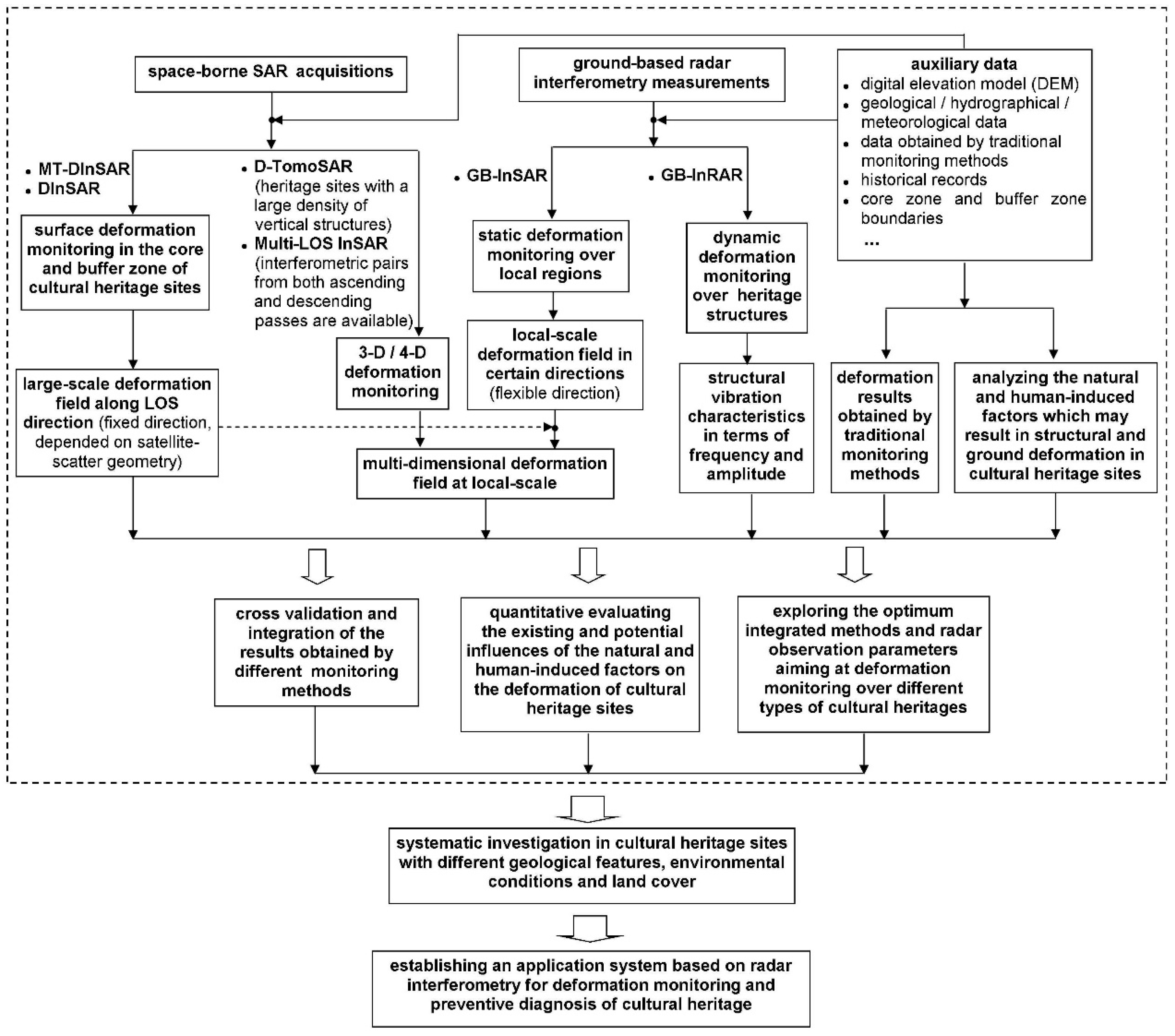
4. Perspectives and Summary

The above analysis demonstrates that the space-borne and ground-based differential radar interferometry approaches have great potential for various scales of deformation monitoring and preventive diagnosis over cultural heritage sites (i.e., from the whole site to a single monument). In practice, different approaches can be used in an integrated manner to set up a multi-scale monitoring workflow combined with geophysical and other auxiliary data. Conducting systematic investigations for heritage sites following a particular workflow model enables the setting up of a radar interferometry application system dedicated to cultural heritage monitoring. Such a system will also provide scientific support for planning the protection and sustainable development of cultural heritage. The workflow we propose in Figure 1 can be implemented as follows:
The first step is to perform a preliminary investigation of the surface deformation over the whole heritage site and its surroundings. MT-InSAR or DInSAR can be applied in large-scale deformation mapping according to the surface features of the heritage site under consideration for highlighting hotpots with deformation anomalies. Besides, multi-LOS DInSAR measurements can be used to reconstruct the large-scale 3D deformation field if the interferometric pairs from both ascending and descending orbits are available. The 3D displacement vectors better reflect the real surface deformation, allowing us to better understand the mechanisms triggering deformation in heritage sites.
Secondly, local-scale deformation monitoring can be carried out over specific areas, such as the unstable units detected by the first step and other groups of monuments or a single archaeological structure of interest. GB-InSAR can be used to detect structural displacements of heritage monuments or could serve as a complementary method of space-borne DInSAR in deformation monitoring at chosen directions; while GB-InRAR can be applied in evaluating the influences of surrounding vibration sources on heritage structures. In particular, GB-InSAR enables us to monitor rapid deformation caused by natural disasters or human activities, providing a useful approach for emergency management of cultural heritage sites. Besides, with respect to heritage sites with a large density of vertical structures, the usage of d-TomoSAR should be taken into consideration in order to separate interfering targets in the vertical direction.
Thirdly, it is important to analyze the mechanisms triggering structural and ground deformation in heritage sites, based on available auxiliary data from geology, hydrography and historical records. Differential radar interferometry only provides information about the superficial effects of deterioration and instability phenomena, which might be caused by different triggering factors. A correct interpretation of the radar data requires substantial background knowledge of the heritage site and field inspections for verification [33]. Based on these comprehensive analyses, the displacement results obtained by different methods (including different radar interferometry approaches and traditional monitoring methods) can be compared for cross-validation. Then, the spatial-temporal deformation processes and their trends can be parameterized using certain indices, e.g., combining deformation velocity rates and acceleration and the scale, which could be useful for the recognition of factors triggering deformation.
Fourthly, the existing and potential influences of natural and human-induced factors on cultural heritage can be quantitatively evaluated, including certain events, e.g., earthquakes, landslides, floods and wars, that lead to rapid deformation and long-term environmental factors or human activities, such as coastal erosion, soil erosion and groundwater pumping, that cause slow deformation. These scientific evaluations are crucial for heritage managers to make appropriate countermeasures for the conservation of cultural heritage. Moreover, quantitative assessments combined with the parameterized displacement results can be used to simulate the spatial-temporal processes of deformation by virtual reality technologies. These technologies demonstrate spatial-temporal phenomena in accurate and dynamic visual scenarios and can play a critical role in narrowing the communication gap between scientists and end-users responsible for heritage management.
In summary, different radar interferometry approaches used in an integrated manner can combine their respective advantages in dealing with diverse heritage sites. According to the characteristics of a specific heritage site and the requirements of end-users, we can also select one or several parts from the proposed workflow to guide monitoring implementation. Based on plenty of systematic investigations over heritage sites with different geological features, environmental conditions and land cover, we can explore the optimum integration of methods and radar observation parameters (e.g., spatial resolution, wavelength, incident angle) dedicated to different scenarios. Then, an application-oriented system can then be set up for anomaly detection and preventive diagnosis of cultural heritage sites. Today, people are much more aware of and focused on culture and civilization issues, which profoundly influence the social and economic development of a nation and its people. The sustainability of cultural heritage is one of our most urgent priorities. On the one hand, cultural heritage management faces conflict of interest between local economic developments and environment conservation, e.g., traveling, deforestation, mining and urban expansion. The proposed workflow can make precise and efficient evaluations of deformation processes and their trends from the site to single monument scale, providing a scientific basis for resource exploitation in and around cultural heritage sites. On the other hand, cultural heritage is also affected by natural factors, particularly natural disasters. Deformation monitoring and preventative diagnosis based on the workflow can contribute to planning appropriate countermeasures for heritage restoration and protection. Furthermore, since the space-borne SAR data are becoming more open to the public, particularly to researchers, limitations regarding cost and ready access of SAR data are likely to be reduced significantly. The establishment and promotion of this system also require a close collaboration amongst archaeologists, radar scientists and cultural heritage managers to improve traditional management approaches. Moreover, by establishing proper communication channels and promoting close cooperation between researchers and end-users, this non-intrusive remote sensing tool could make unique contributions to the sustainability of the cultural heritage of humankind.
Figure 1. A workflow model for deformation monitoring and preventive diagnosis that could ultimately lead to the setting up of a differential radar interferometry application system dedicated to cultural heritage site monitoring (within the box enclosed by the dashed line). Ground-based and satellite SAR data can be integrated to retrieve multi-dimensional deformation fields (shown as the dashed line with the arrowhead).
Sustainability 07 01712 g001

Acknowledgments

This study has been supported by funding from the Hundred Talents Program of Chinese Academy of Sciences (Y5YR0300QM), and the National Natural Science Foundation of China (41201455); partial support was also provided by the International S&T Cooperation Program of China (2013DFG21640). We thank Natarajan Ishwaran from the Institute of Remote Sensing and Digital Earth, Chinese Academy of Sciences, for his kind help with revising the manuscript of this paper.

Author Contributions

Wei Zhou wrote the first draft of this review. Fulong Chen and Huadong Guo reviewed and provided valuable comments for revising the original manuscript. All the authors contributed to developing the ideas presented and the improvement of the paper.

Conflicts of Interest

The authors declare no conflict of interest.

References

  1. Rossi, P.P.; Rossi, C. Surveillance and monitoring of ancient structures: Recent developments. In Proceedings of the 2nd International Seminar on Structural Analysis of Historical Constructions, Barcelona, Spain, 4–6 November 1998; pp. 163–178.
  2. Inaudi, D.; Casanova, N.; Glisic, B. Long-term deformation monitoring of historical constructions with fiber optic sensors. In Proceedings of the 3rd International Seminar on Structural Analysis of Historical Constructions, Guimaraes, Portugal, 7–9 November 2001; pp. 421–430.
  3. Del Grosso, A.; Torre, A.; Rosa, M.; Lattuada, B. Application of SHM techniques in the restoration of historical buildings: The Royal Villa of Monza. In Proceedings of the 2nd European Conference on Health Monitoring, Munich, Germany, 7–9 July 2004.
  4. Garziera, R.; Amabili, M.; Collini, L. Structural health monitoring techniques for historical buildings. In Proceedings of the 4th Pan-American Conference for Non-Destructive Testing, Buenos Aires, Argentina, 22–26 October 2007.
  5. Glisic, B.; Inaudi, D. Fiber Optic Methods for structural Health Monitoring; John Wiley & Sons: Hoboken, NJ, USA, 2008. [Google Scholar]
  6. Glisic, B.; Inaudi, D.; Posenato, D.; Figini, A.; Casanova, N. Monitoring of heritage structures and historical monuments using long-gage fiber optic interferometric sensors—An overview. In Proceedings of the 3rd International Conference on Structural Health Monitoring of Intelligent Infrastructure-SHMII-3, Vancouver, BC, Canada, 13–16 November 2007.
  7. Gabriel, A.K.; Goldstein, R.M.; Zebker, H.A. Mapping small elevation changes over large areas: Differential radar interferometry. J. Geophys. Res. 1989, 94, 9183–9191. [Google Scholar] [CrossRef]
  8. Bürgmann, R.; Rosen, P.A.; Fielding, E.J. Synthetic aperture radar interferometry to measure Earth’s surface topography and its deformation. Annu. Rev. Earth Planet. Sci. 2000, 28, 169–209. [Google Scholar] [CrossRef]
  9. Massonnet, D.; Feigl, K.L. Radar interferometry and its application to changes in the Earth’s surface. Rev. Geophys. 1998, 36, 441–500. [Google Scholar] [CrossRef]
  10. Luzi, G. Ground based SAR interferometry: A novel tool for Geoscience. In Geoscience And Remote Sensing, New Achievements; Imperatore, P., Riccio, D., Eds.; InTech: Rijeka, Croatia, 2010; pp. 1–26. [Google Scholar]
  11. Parcharidis, I.; Foumelis, M.; Pavlopoulos, K.; Kourkouli, P. Ground deformation monitoring in cultural heritage areas by time series SAR interferometry: The case of ancient Olympia site (western Greece). In Proceedings of the ESA FRINGE Workshop, Frascati, Italy, 30 November–4 December 2009.
  12. Zeni, G.; Bonano, M.; Casu, F.; Manunta, M.; Manzo, M.; Marsella, M.; Pepe, A.; Lanari, R. Long-term deformation analysis of historical buildings through the advanced SBAS-DInSAR technique: The case study of the city of Rome, Italy. J. Geophys. Eng. 2011. [Google Scholar] [CrossRef]
  13. Bock, Y.; Wdowinski, S.; Ferretti, A.; Novali, F.; Fumagalli, A. Recent subsidence of the Venice Lagoon from continuous GPS and interferometric synthetic aperture radar. Geochem. Geophys. Geosyst. 2012. [Google Scholar] [CrossRef]
  14. Tapete, D.; Fanti, R.; Cecchi, R.; Petrangeli, P.; Casagli, N. Satellite radar interferometry for monitoring and early-stage warning of structural instability in archaeological sites. J. Geophys. Eng. 2012, 9, S10–S25. [Google Scholar] [CrossRef]
  15. Hooper, A. A multi-temporal InSAR method incorporating both persistent scatterer and small baseline approaches. Geophys. Res. Lett. 2008. [Google Scholar] [CrossRef]
  16. Berardino, P.; Fornaro, G.; Lanari, R.; Sansosti, E. A new algorithm for surface deformation monitoring based on small baseline differential SAR interferograms. IEEE Trans. Geosci. Remote Sens. 2002, 40, 2375–2383. [Google Scholar] [CrossRef]
  17. Ferretti, A.; Prati, C.; Rocca, F. Permanent scatterers in SAR interferometry. IEEE Trans. Geosci. Remote Sens. 2001, 39, 8–20. [Google Scholar] [CrossRef]
  18. Ferretti, A.; Fumagalli, A.; Novali, F.; Prati, C.; Rocca, F.; Rucci, A. A new algorithm for processing interferometric data-stacks: SqueeSAR. IEEE Trans. Geosci. Remote Sens. 2011, 49, 3460–3470. [Google Scholar] [CrossRef]
  19. Hooper, A.; Zebker, H.; Segall, P.; Kampes, B. A new method for measuring deformation on volcanoes and other natural terrains using InSAR persistent scatterers. Geophys. Res. Lett. 2004. [Google Scholar] [CrossRef]
  20. Hooper, A.; Bekaert, D.; Spaans, K.; Arıkan, M. Recent advances in SAR interferometry time series analysis for measuring crustal deformation. Tectonophysics 2012. [Google Scholar] [CrossRef]
  21. Lanari, R.; Mora, O.; Manunta, M.; Mallorquí, J.J.; Berardino, P.; Sansosti, E. A small-baseline approach for investigating deformations on full-resolution differential SAR interferograms. IEEE Trans. Geosci. Remote Sens. 2004, 42, 1377–1386. [Google Scholar] [CrossRef]
  22. Chen, F.; Lin, H.; Zhou, W.; Hong, T.; Wang, G. Surface deformation detected by ALOS PALSAR small baseline SAR interferometry over permafrost environment of Beiluhe section, Tibet Plateau, China. Remote Sens. Environ. 2013, 138, 10–18. [Google Scholar] [CrossRef]
  23. Chen, F.; Lin, H.; Zhang, Y.; Lu, Z. Ground subsidence geo-hazards induced by rapid urbanization: Implications from InSAR observation and geological analysis. Nat. Hazards Earth Syst. Sci. 2012, 12, 935–942. [Google Scholar] [CrossRef] [Green Version]
  24. Cigna, F.; Osmanoğlu, B.; Cabral-Cano, E.; Dixon, T.H.; Ávila-Olivera, J.A.; Garduño-Monroy, V.H.; DeMets, C.; Wdowinski, S. Monitoring land subsidence and its induced geological hazard with Synthetic Aperture Radar Interferometry: A case study in Morelia, Mexico. Remote Sens. Environ. 2012, 117, 146–161. [Google Scholar] [CrossRef]
  25. Ferretti, A.; Prati, C.; Rocca, F. Nonlinear subsidence rate estimation using permanent scatterers in differential SAR interferometry. IEEE Trans. Geosci. Remote Sens. 2000, 38, 2202–2212. [Google Scholar] [CrossRef]
  26. Werner, C.; Wegmuller, U.; Strozzi, T.; Wiesmann, A. Interferometric point target analysis for deformation mapping. In Proceedings of the IEEE International Geoscience and Remote Sensing Symposium, Toulouse, France, 21–25 July 2003; pp. 4362–4364.
  27. Chen, F.; Lin, H.; Hu, X. Slope superficial displacement monitoring by small baseline SAR interferometry using data from l-band ALOS PALSAR and X-band TerraSAR: A case study of Hong Kong, China. Remote Sens. 2014, 6, 1564–1586. [Google Scholar] [CrossRef]
  28. Arangio, S.; Calò, F.; Di Mauro, M.; Bonano, M.; Marsella, M.; Manunta, M. An application of the SBAS-DInSAR technique for the assessment of structural damage in the city of Rome. Struct. Infrastruct. Eng. 2013. [Google Scholar] [CrossRef]
  29. Giannico, C.; Ferretti, A.; Alberti, S. Satellite Radar interferometry: A new monitoring tool for cultural heritage sites. In Proceedings of the International Conference: Built Heritage 2013. Monitoring Conservation and Management, Milan, Italy, 18–20 November 2013; pp. 655–662.
  30. Manunta, M.; Marsella, M.; Zeni, G.; Sciotti, M.; Atzori, S.; Lanari, R. Two-scale surface deformation analysis using the SBAS-DInSAR technique: A case study of the city of Rome, Italy. Int. J. Remote Sens. 2008, 29, 1665–1684. [Google Scholar] [CrossRef]
  31. Tapete, D.; Cigna, F. Rapid mapping and deformation analysis over cultural heritage and rural sites based on Persistent Scatterer Interferometry. Int. J. Geophys. 2012. [Google Scholar] [CrossRef]
  32. UNESCO. Mexico City: Support for Heritage Management. Available online: http://www.unesco.org/new/en/natural-sciences/science-technology/space-activities/space-for-heritage/activities/open-initiative-projects/mexico-city-support-for-heritage-management/ (accessed on 15 May 2013).
  33. Reigber, A.; Moreira, A. First demonstration of airborne SAR tomography using multibaseline l-band data. IEEE Trans. Geosci. Remote Sens. 2000, 38, 2142–2215. [Google Scholar] [CrossRef]
  34. Fornaro, G.; Serafino, F.; Reale, D. 4-D SAR imaging: The case study of Rome. IEEE Geosci. Remote Sens. Lett. 2010, 7, 236–240. [Google Scholar] [CrossRef]
  35. Tapete, D.; Casagli, N.; Luzi, G.; Fanti, R.; Gigli, G.; Leva, D. Integrating radar and laser-based remote sensing techniques for monitoring structural deformation of archaeological monuments. J. Archaeol. Sci. 2013, 40, 176–189. [Google Scholar] [CrossRef] [Green Version]
  36. Tarchi, D.; Rudolf, H.; Pieraccini, M.; Atzeni, C. Remote monitoring of buildings using a ground-based SAR: Application to cultural heritage survey. Int. J. Remote Sens. 2000, 21, 3545–3551. [Google Scholar] [CrossRef]
  37. Pieraccini, M.; Tarchi, D.; Rudolf, H.; Leva, D.; Luzi, G.; Atzeni, G. Interferometric radar for remote monitoring of building deformations. Electron. Lett. 2000, 36, 569–570. [Google Scholar] [CrossRef]
  38. Cappellini, A.; Leva, D.; Rivolta, C.; Vanali, M. Use of Non-Contact radar techniques to dynamics measurement purposes. In Topics in Modal Analysis II; Springer: New York, NY, USA, 2012; Volume 6, pp. 247–254. [Google Scholar]
  39. Gentile, C.; Bernardini, G. An interferometric radar for non-contact measurement of deflections on civil engineering structures: Laboratory and full-scale tests. Struct. Infrastruct. Eng. 2010, 6, 521–534. [Google Scholar] [CrossRef]
  40. Luzi, G.; Monserrat, O.; Crosetto, M. Real aperture radar interferometry as a tool for buildings vibration monitoring: Limits and potentials from an experimental study. In Proceedings of the 10th International Conference on Vibration Measurements by Laser and Non-Contact Techniques-AIVELA 2012, Ancona, Italy, 26–29 June 2012; AIP Publishing: MD, USA, 2012; Volume 1457, pp. 309–317. [Google Scholar]
  41. Pieraccini, M. Monitoring of civil infrastructures by interferometric radar: A review. Sci. World J. 2013. [Google Scholar] [CrossRef]
  42. Alba, M.; Bernardini, G.; Giussani, A.; Ricci, P.P.; Roncoroni, F.; Scaioni, M.; Valgoi, P.; Zhang, K. Measurement of dam deformations by terrestrial interferometric techniques. Int. Arch. Photogramm. Remote Sens. Spat. Inf. Sci. 2008, 37, 133–139. [Google Scholar]
  43. Antonello, G.; Casagli, N.; Farina, P.; Leva, D.; Nico, G.; Sieber, A.J.; Tarchi, D. Ground-based SAR interferometry for monitoring mass movements. Landslides 2004, 1, 21–28. [Google Scholar] [CrossRef]
  44. Casagli, N.; Tibaldi, A.; Merri, A.; Ventisette, C.D.; Apuani, T.; Guerri, L.; Fortuny-Guasch, J.; Tarchi, D. Deformation of Stromboli Volcano (Italy) during the 2007 eruption revealed by radar interferometry, numerical modeling and structural geological field data. J. Volcanol. Geotherm. Res. 2009, 182, 182–200. [Google Scholar] [CrossRef]
  45. Casagli, N.; Catani, F.; del Ventisette, C.; Luzi, G. Monitoring, prediction, and early warning using ground-based radar interferometry. Landslides 2010, 7, 291–301. [Google Scholar] [CrossRef]
  46. Bartoli, G.; Facchini, L.; Pieraccini, M.; Fratini, M.; Atzeni, C. Experimental utilization of interferometric radar techniques for structural monitoring. Struct. Control Health Monit. 2008, 15, 283–298. [Google Scholar] [CrossRef]
  47. Farrar, C.R.; Darling, T.W.; Migliori, A.; Baker, W.E. Microwave interferometers for non-contact vibration measurements on large structures. Mech. Syst. Signal Process. 1999, 13, 241–253. [Google Scholar] [CrossRef]
  48. Gentile, C. Deflection measurement on vibrating stay cables by non-contact microwave interferometer. NDT E Int. 2010, 43, 231–240. [Google Scholar] [CrossRef]
  49. Luzi, G.; Monserrat, O.; Crosetto, M. The potential of coherent radar to support the monitoring of the health state of buildings. Res. Nondestruct. Eval. 2012, 23, 125–145. [Google Scholar] [CrossRef]
  50. Pieraccini, M.; Fratini, M.; Parrini, F.; Atzeni, C.; Bartoli, G. Interferometric radar vs. accelerometer for dynamic monitoring of large structures: An experimental comparison. NDT E Int. 2008, 41, 258–264. [Google Scholar] [CrossRef]
  51. Rainer, J.H. Effect of vibrations on historic buildings: An overview. Bull. Assoc. Preserv. Technol. 1982, 14, 2–10. [Google Scholar] [CrossRef]
  52. Sedovic, W. Assessing the effect of vibration on historic buildings. Bull. Assoc. Preserv. Technol. 1984, 16, 52–61. [Google Scholar] [CrossRef]
  53. Fratini, M.; Pieraccini, M.; Atzeni, C.; Betti, M.; Bartoli, G. Assessment of vibration reduction on the Baptistery of San Giovanni in Florence (Italy) after vehicular traffic block. J. C. Herit. 2011, 12, 323–328. [Google Scholar] [CrossRef]
  54. Gentile, C.; Saisi, A. Ambient vibration testing and condition assessment of the Paderno iron arch bridge (1889). Constr. Build. Mater. 2011, 25, 3709–3720. [Google Scholar] [CrossRef]
  55. Gentile, C.; Saisi, A. Dynamic measurement on historic masonry towers by microwave remote sensing. In Proceedings of the International Conference on Experimental Vibration Analysis for Civil Engineering Structures (EVACES), Varenna, Italy, 3–5 October 2011; Volume 2, pp. 524–530.
  56. Pieraccini, M.; Dei, D.; Betti, M.; Bartoli, G.; Tucci, G.; Guardini, N. Dynamic identification of historic masonry towers through an expeditious and no-contact approach: Application to the “Torre del Mangia” in Siena (Italy). J. C. Herit. 2013, 15, 275–282. [Google Scholar] [CrossRef]
  57. Fornaro, G.; Reale, D.; Serafino, F. 4D SAR focusing: A tool for improved imaging and monitoring of urban areas. In Proceedings of the IEEE International Geoscience and Remote Sensing Symposium, Boston, MA, USA, 6–11 July 2008; pp. V475–V478.
  58. Fornaro, G.; Reale, D.; Serafino, F. Four-dimensional SAR imaging for height estimation and monitoring of single and double scatterers. IEEE Trans. Geosci. Remote Sens. 2009, 47, 224–237. [Google Scholar] [CrossRef]
  59. Zhu, X.X.; Bamler, R. Let’s do the time warp: Multicomponent nonlinear motion estimation in differential SAR tomography. IEEE Geosci. Remote Sens. Lett. 2011, 8, 735–739. [Google Scholar] [CrossRef]
  60. Zhu, X.X.; Bamler, R. Very high resolution SAR tomography via compressive sensing. In Proceedings of the Fringe 2009, Frascati, Italy, 30 November–4 December 2009.
  61. Wasowski, J.; Bovenga, F. Investigating landslides and unstable slopes with satellite multi temporal interferometry: Current issues and future perspectives. Eng. Geol. 2014, 174, 103–138. [Google Scholar] [CrossRef]
  62. Eineder, M.; Adam, N.; Bamler, R.; Yague-Martinez, N.; Breit, H. Spaceborne spotlight SAR interferometry with TerraSAR-X. IEEE Trans. Geosci. Remote Sens. 2009, 47, 1524–1535. [Google Scholar] [CrossRef]
  63. Bamler, R.; Hartl, P. Synthetic aperture radar interferometry. Inverse Probl. 1998, 14, R1–R54. [Google Scholar] [CrossRef]
  64. Chen, F.; Lin, H.; Li, Z.; Chen, Q.; Zhou, J. Interaction between permafrost and infrastructure along the Qinghai–Tibet Railway detected via jointly analysis of C-band l-band small baseline SAR interferometry. Remote Sens. Environ. 2012, 123, 532–540. [Google Scholar] [CrossRef]
  65. Bovenga, F.; Wasowski, J.; Nitti, D.O.; Nutricato, R.; Chiaradia, M.T. Using Cosmo/SkyMed X-band and ENVISAT C-band SAR interferometry for landslide analysis. Remote Sens. Environ. 2012, 119, 272–285. [Google Scholar] [CrossRef]
  66. Guo, H. Radar for Earth Observation: Theory and Applications; Science Press: Beijing, China, 2000. (In Chinese) [Google Scholar]
  67. Chen, F.; Lin, H. Multi-baseline differential SAR interferometry analysis of Lantau Highway, Hong Kong, using ENVISAT ASAR data. Remote Sens. Lett. 2011, 2, 167–173. [Google Scholar] [CrossRef]
  68. Ferretti, A.; Savio, G.; Barzaghi, R.; Borghi, A.; Musazzi, S.; Novali, F.; Prati, C.; Rocca, F. Submillimeter accuracy of InSAR time series: Experimental validation. IEEE Trans. Geosci. Remote Sens. 2007, 45, 1142–1153. [Google Scholar] [CrossRef]
  69. Tapete, D.; Casagli, N.; Fanti, R.; del Ventisette, C.; Cecchi, R.; Petrangeli, P. Satellite and ground-based radar interferometry for detection and monitoring of structural instability in archaeological sites. Avaiable online: http://meetingorganizer.copernicus.org/EGU2011/EGU2011-8387.pdf (accessed on 4 February 2015).
  70. Bardi, F.; Frodella, W.; Ciampalini, A.; Bianchini, S.; del Ventisette, C.; Gigli, G.; Fanti, R.; Moretti, S.; Basile, G.; Casagli, N. Integration between ground based and satellite SAR data in landslide mapping: The San Fratello case study. Geomorphology 2014, 223, 45–60. [Google Scholar] [CrossRef]
  71. Fialko, Y.; Simons, M. The complete (3-D) surface displacement field in the epicentral area of the 1999 Mw7.1 Hector Mine earthquake, California, from space geodetic observations. Geophys. Res. Lett. 2001, 28, 3063–3066. [Google Scholar] [CrossRef]
  72. Simons, M.; Rosen, P.A. Interferometric synthetic aperture radar geodesy. In Treatise on Geophysics; Elsevier: Amaterdam, The Netherlands, 2007; Volume 3, pp. 391–447. [Google Scholar]
  73. Bechor, N.B.D.; Zebker, H.A. Measuring two-dimensional movements using a single InSAR pair. Geophys. Res. Lett. 2006. [Google Scholar] [CrossRef]
  74. Lasaponara, R.; Masini, N. Satellite synthetic aperture radar in archaeology and cultural landscape: An overview. Archaeol. Prospect. 2013, 20, 71–78. [Google Scholar] [CrossRef]

