Parking Site Selection for Light Rail Stations in Muaeng District, Khon Kaen, Thailand


Department of Geoinformatics, Faculty of Informatics, Mahasarakham University, Kantarawichai District, Maha Sarakham 44150, Thailand
*
Author to whom correspondence should be addressed.
Symmetry 2020, 12(6), 1055; https://0-doi-org.brum.beds.ac.uk/10.3390/sym12061055
Submission received: 28 May 2020
/
Revised: 19 June 2020
/
Accepted: 22 June 2020
/
Published: 25 June 2020
Abstract
:Khon Kaen District is in the central, north-east part of Thailand and is being developed to handle the country’s growth. Khon Kaen District is undertaking the project of building a light rail as a facility for the people. Consequently, one of the problems is ensuring adequate parking for people using the light rail service. In general, the symmetry concept naturally used in decision making to finding an optimal solution for decision and optimization problems. In this paper, multi-criteria decision analysis (MCDA) and multi-objective decision making (MODM) were used to solve the parking site selection problem, which made the decision easier. This paper proposed an analytic hierarchy process (AHP) technique, combined with the geographical information system (GIS), to evaluate the weight of the criteria used in the analysis and find potential parking solutions. Furthermore, this paper proposed the application of a linguistic technique with fuzzy TOPSIS methods to analyze the appropriateness of parking site selections from potential candidates to support use of the light rail. The results of the MCDA show that the most suitable parking lot location is along the light rail and closest to the business area. The results of the fuzzy TOPSIS method, both positive and negative ideal decisions, can help inform decision makers in selecting which candidate site is optimal for parking.
1. Introduction
The Khon Kaen light rail project is one of many projects to develop Khon Kaen as a Smart City. Khon Kaen’s Smart City development program is one of the country’s 12th national social and economic plan (2017–2021). The Khon Kaen light rail transit project is planned to be 22.6 km long, consisting of an initial 16 stations to serve Khon Kaen province in northeast Thailand [1]. This project was founded by a community of businesspeople in Khon Kaen who struggled to find their own solution, so they came up with the “Khon Kaen Model.” The transit-oriented development (TOD) model is used to develop mass transit as the backbone for real estate and urban development. If successfully implemented, Khon Kaen will be the second city in Thailand (the other being Bangkok) to have its own rail system [2]. In addition, one of the main problems is ensuring adequate parking for customers to be able to park easily and comfortably. Parking has become one of the most important factors for urban planners to consider in their work. Lack of accessible parking can hurt local businesses and decrease the quality of life for residents [3]. However, the parking site selection problem is challenging for finding an optimal solution from the multi-criteria problem. Multi-criteria optimization is an area that deals with the decision making of mathematical combined with optimization problems to solving the best of alternatives that play the role of the symmetry concepts.
Location selection is treated as a three-stage process—stage 1 deals with finding a suitable area with the selection of a geographical region or state, stage 2 deals with the selection of a particular locality as a candidate site, and stage 3 deals with the selection of the optimal final site [4]. In stage 1, suitable sites for public parking are selected using geographical information system (GIS). Traditional methods of selecting suitable sites have included Boolean methods [5,6] or overlay operation methods [7]. Boolean overlay of binary thematic layers offers a simple and quick approach to a suitability analysis with GIS. In general, with Boolean methods, all influencing factors are of equal importance. However, for many suitability analyses, the eligibility criteria are more important items in the overall set of criteria. In recent years, multi-criteria decision analysis (MCDA) can provide support for solving decision-making problems in fields of a multidisciplinary nature, and factors to be simultaneously optimized to achieve the evaluation objectives. [8]. The main purposes of this paper are to consider the importance of different criteria by determining the weight to assigned to each criterion for analysis and to find potential parking solutions. In MCDA, one method considered is determining the weighting of criteria by decision making combined with the weighted criteria—namely, the simple additive weighting (SAW) method [9,10,11]. A suitable analysis is necessary to consider the importance of the weight assigned to the criteria relative to the impact of the problem. The relational importance of the weight should compare each criterion against all others—this method is also called pair-wise comparison. The analytic hierarchy process (AHP) method builds a pair-wise comparison model for determining the weights for every unique criterion [12]. The AHP, introduced by Saaty [13], is a measurement theory that uses pairwise comparisons and relies on the judgement of experts to derive priority scales. The comparison is made using a complete judgment that represents the scale of elements that influence other elements with respect to a given attribute.
The stage of location selection considers suitable location alternatives and generally requires processing a variety of data such as economic and environmental parameters. However, the problem of location selection is difficult to solve because there are many conflicting goals [14]. There are many studies on facility location evaluation and selection methods. In recent years, multi-criteria decision making (MCDM) has been used for considering evaluation or selection problems in facility location. The classic approach to MCDM includes multi-attribute decision making (MADM) and multi-objective decision making (MODM) for solved the decision-making problem. MADM is the most well-known method and requires that the choices among decision alternatives are described by a number of attributes. The alternative to MADM includes different choices from the methods for combing the information contained in the decision matrix, including attribute values and attribute weights. An attribute can be represented in different dimensions, which means that MADM techniques require additional information from the decision-maker to rank them, screen them, or a final selection. The attribute value describes the characteristics, quality, and performance of the alternatives. The weight of the attribute is used to measure the importance of attributes. Because of the complexity of the real world and the knowledge and capacity to recognize limitations, both attribute values and the weight of the attributes are uncertain. [15].
The AHP method is one MCDM method and has been widely used for location selection. AHP has been used for site selection with multiple alternatives and criteria by using pair-wise comparisons and matrix algebra to weight the criteria. Usually, a decision maker should give interval judgments on a scale of 1–9 to determine pairwise comparisons. In some problems, a decision maker cannot be explicit about their exact pairwise comparison judgments. To resolve the ambiguous problems of decision maker judgment [16], fuzzy AHP was proposed to identify the weights through AHP operations by using triangular fuzzy numbers.
The MODM method is a systematic decision-making process that cannot be determined. MODM provides a mathematical framework for designing a set of decision-making alternatives. MODM allows decision makers to define their own configuration systems, frame context, and systematically evaluate decisions to determine which is close to objectives or multiple objectives. The MODM application function is created to measure the compliance level of the decision-makers (achieving the goal close to the ideal point of satisfaction.) in objective functions and is widely used in the process of finding “good compromise” solutions [17]. In the real world, decision problems are conflicted by objective functions and constraints because the right alternative is not known to a decision maker. Multi-objective optimization provides a framework for solving decision making problems involving multiple objectives. Multi-objective optimization involves optimizing a number of objectives simultaneously. The problem becomes a challenge when the objective conflict—which is the best solution to the work of the objective—is different from the other. With or without the presence of constraints, these problems contribute to a set of trade-off optimal solutions called pareto-optimal solutions [18]. Several techniques use the solution of multi-objective optimization problems and require input from the decision maker, including the ranking, weighting, or attainability information of an objective.
Based on the process of location selection, the aim of this paper is to determine suitable parking sites based on GIS and multi-criteria decision analysis using AHP methods. The selection of parking locations to service the light rail (LRT) user population included multi-objective decision making using the fuzzy TOPSIS method. This paper is divided into six sections as follows: Section 1 is an introduction that provides readers with an overall perspective and describes the motivation and innovation of the article. Section 2 includes an intensive review of the article and describes the relevant methods, while Section 3 presents the mixed integer programming. Section 4 shows the computational results, while Section 5 discusses those results. Section 6 is the conclusion of the article.
2. Literature Review
In the literature, the focus has been on parking site selection based on MCDA and MODM. Traditional site suitability analyses in various fields use an overlay technique with factors to analyze suitability potential based on GIS. The analysis should determine the scoring and weighting to apply the factors to various aspects of suitability. However, the importance of determining the weight of the criteria affects the suitability results, which is a problem in multi-criteria analysis. Malczewski [19] introduced MCDA with criteria to solve spatial decision problems. Additionally, Malczewski [20] presented a survey of GIS-MCDA in several research articles from 1990–2004, and over 300 articles showed that the weighted summation or SAW methods were most commonly used in GIS-MCDA research. Kulinich and Lee [21] presented methods for parking site selection using GIS and MCDA, and the process consisted of two steps—the first step was to find effective criteria for parking site selection, and the second was to use traditional MCDA weighted overlay methods to analyze the suitability of potential parking lots.
Recently, the AHP method has been most used for the implementation of evaluation criteria by pair-wise comparisons to determine the weight of each criterion. Researchers have used the AHP approach in parking site selection. Karimi et al. [22] presented suitable public parking site selections by using GIS and considering almost all of the effective parameters simultaneously. In this article, the proposed AHP approach was preferred in weighting parking lot parameters because of its double-parameter comparisons, simplicity of use, and its high accuracy. Farzanmanesh et al. [23] determined the best suitable parking area, divided into three stages. First, effective criteria are described for parking selection by giving proper weights and using them in MCDM. The AHP approach was selected at this stage, and after the criteria were selected, the mathematical model was developed using the results of the pairwise comparison model. Second, mathematical models of the selected area were used in GIS. Finally, the best suitable parking space is found using fuzzy logic. In Baseri et al.’s [24] research, effective criteria are first declared in parking site selection. Then, in a GIS environment, layers related to each criterion were provided, and by use AHP’s multi-criteria decision-making model, the layers with regard to their importance coefficients were combined and overlain with each other. The ultimate layer determined the most utilitarian parking lot width.
Nazarboland and Izadi [25] presented MCDA based on AHP to select public parking sites in the city of Shiraz by using pairwise comparisons of each factor. The objectives were to reduce traffic in the streets, improve the efficiency of the land, provide services, make parking construction as financially profitable as possible, optimize site selection and implement neighborhood parking facilities, investigate the problems of urban neighborhoods and their needs for neighborhood parking facilities, and determine appropriate strategies for resolving the problems by taking into consideration nearby areas. Aliniai et al. [26] presented two-step parking site selection. The first step included preparing the criteria and sub-criteria, and maps were weighted using AHP methods. A pairwise comparison matrix of the main criteria incorporated the distance from urban attraction centers, distance from passages, cost of real estate, and suitable land use for parking lots. In the second step, site selection results were tested in multiple states using the fuzzy ordered weighted averaging (OWA) method.
Jelokhani-Niaraki and Malczewski [27] presented a web-based group GIS-MCDA procedure and tools for addressing parking site selection issues in Tehran. The integration of GIS and MCDA capabilities with a web platform offered an effective multi-criteria spatial decision support system (MC-SDSS) related to stakeholders and other groups in site selection processes. Such a system makes it possible to find appropriate sites, which may reconcile conflicting objectives caused by different opinions, and results in a final site selection that is acceptable by the majority. He et al. [28] presented a site selection method for public parking lots. First, future parking demands were forecasted by the parking rate model. Second, the preliminary locations and quantity of parking lots were determined by the AHP. Finally, a multi-objective site selection model was established along with the genetic algorithm. The final location and size of parking lots were determined by the multi-objective model and genetic algorithm. This paper showed that three-step methods are feasible and can help decision makers plan public parking lots in new districts.
Previous research has been limited to parking site selection based on a geographic information system and multi-criteria decision analysis. The parking site selection problem in multi-objective optimization has not been examined in prior studies. This section points out some of the problems encountered in extant research on multi-objective optimization in the facility location selection problem, which is similar to parking site selection. Multi-objective analysis of facility location problems can be classified into one of four general categories—cost minimization, demand-oriented, profit maximization, and environmental concern [29]. In addition, the methods of the technique for order preference by similarity to ideal solution (TOPSIS) in parking site selection, or similar facility location optimization problems, have been considered.
TOPSIS, developed by Hwang and Yoon [30], is a technique to determine the best alternative based on the concept of compromise to get a similar ideal solution. Consequently, the best alternative to this technique would be the shortest distance from the positive ideal solution and the longest distance from the negative ideal solution. The positive ideal solution to which all criteria values correspond maximizes the benefit value and minimizes the cost value. The negative ideal solution to which the criteria values corresponds maximizes the cost value and minimizes the benefit value [30,31]. TOPSIS methods, such as MCDM, have been applied to get the ideal solutions for each alternative [32]. TOPSIS methods and MCDM have been applied in several studies [33,34,35,36,37,38,39]. which are used for ranking research selection. Although TOPSIS is widely used in decision-making problems, this technique is often criticized for its inability to adequately deal with uncertainty in the process of mapping the perception of decision makers [40].
Many studies have continually introduced the fuzzy concept to improve TOPSIS. For example, Chen [41] presented extensions of the TOPSIS for group decision making under a fuzzy environment. This method used linguistic variables to express the ranking of each alternative, and the weight of each criterion was described in linguistic terms, which can be expressed as triangular fuzzy numbers. Krohling and Campanharo [40] proposed a fuzzy TOPSIS model for group decision making, which was applied to evaluate the ratings of alternatives in response to simulated oil spills. Yalcin and Pehivan [42] presented a literature review on researchers who used the fuzzy MCDM methods in personnel selection problems, and they observe that the fuzzy TOPSIS method was popular due to its simplicity, ease of use, and flexibility. Adeel et al. [43] proposed a fuzzy linguistic TOPSIS approach for group decision making used to evaluate the best alternative for more authentic and comparable results, and to deal with real-life problems of having multi-polar information in terms of linguistic variables.
The literature demonstrates methodology for solving the problems of parking site suitability and site selection using GIS and MCDA. In addition, multi-objective optimization in facility location selection problems, which are similar to parking site selection, has been presented. This paper proposed AHP to determine potential parking site alternatives and fuzzy TOPSIS to solve the multi-objective parking site selection decision in order to serve the LRT user population.
3. Materials and Methods
In this study, the proposed multi-objective method to optimize parking site selection had two main stages.
Stage 1: The suitable parking area was determined using spatial analysis by the AHP technique to calculate a weight for each criterion from the matrix of pairwise comparisons including road, urban, water bodies, land use, business land, governmental land, rails, and light rails. After that, the simple additive weighting (SAW) method was applied, which is a simple method to determine the suitable parking area.
Stage 2: The highest-ranked parking site was selected based on the optimized criteria.
3.1. Determining the Suitable Parking Area using MCDA
The analytic hierarchy process (AHP), introduced by Saaty [13], is an effective tool for dealing with complex decision making, and it may aid decision makers in setting priorities and making the best decision. The process of AHP is as follows:
- Define the problem and define the criteria. Factors and related sub factors must be correlated.
For each comparison, this paper will decide which of the two criteria is the most important, and then a score will be assigned to show how much more important it is.
- Each element of the comparison matrix is computed by its column total, and the priority vector is calculated by row averages.
- A weighted-sum matrix is found by multiplying the pairwise comparison matrix and priority vector.
- All elements of the weighted-sum matrix are divided by their respective priority vector element.
- The consistency ratio (CR) is computed to evaluate if the comparisons made by the decision maker are consistent. Saaty recommended that the CR value should be less than 0.1.
The most suitable method of multi-criteria decision analysis is the weighted linear combination (WLC), which was the conducted through the weighted overlay function. Simple addition weighting (SAW), which is also known as WLC or scoring methods, is the simplest and is mostly used in multi-attribute decision techniques. This method is calculated for each alternative by multiplying the scaled value of the attribute with the weights of AHP by the following formula:
where
- Ai is the alternative;
- wi is the weighted criteria;
- xi is the score of the ith alternative with respect to the jth criteria.
3.2. Multi-Objective Decision Making for Parking Site Selection Servicing the Light Rail Station
Parking sites were selected from the highest-ranked suitable parking areas as follows:
- A spatial grid cell of the parking area was created using fishnet grids of 500 m * 500 m.
- The ideal solution and negative ideal solution for each criterion were defined by the decision maker. The concept of an ideal solution in choosing the best alternative parking site depended on the maximum benefit and minimum cost criteria. The criteria for selection of parking sites were as follows:
- (1)
- Distance from commercial centers;
- (2)
- Distance from the railway;
- (3)
- Distance from official governmental centers;
- (4)
- Distance from the light rail station;
- (5)
- Distance from educational and recreational centers.
The scale parameters of each criterion are defined in Table 2. - TOPSIS was consider the ideal point of the goal to be achieved, which is that the chosen alternative should have the closest distance to the positive ideal point and farthest distance from the negative ideal point. The steps of TOPSIS are as follows:
- (1)
- Assignment rating to the criteria and weighting the alternatives;
- (2)
- Compute the normalized rating;
- (3)
- Calculate weighted normalized matrix;
- (4)
- Calculate the ideal best and ideal worst values;
- (5)
- Calculate the Euclidean distance of the ideal.
- Calculate the Euclidean distance from the ideal best.where
- is the alternative distance to the positive ideal point;
- is the alternative;
- is the maximum positive ideal point.
- Calculate the Euclidean distance from the ideal worstwhere
- is the alternative distance to the negative ideal point;
- is the alternative;
- is the maximum negative ideal point.
- (6)
- Calculate the relative closeness to the positive ideal solution ()
- (7)
- Rank the preference order the alternative closest to 1.
- Fuzzy TOPSIS was used to calculate the ideal parking site locations to service the light rail station (LRT) population. According to Chen’s approach [41], the procedure of fuzzy TOPSIS can be expressed in the following steps:
- (1)
- (2)
- Compute the normalized fuzzy decision matrix.
- (3)
- Calculate the weighted normalized fuzzy decision matrix.
- (4)
- Calculate the fuzzy ideal best and fuzzy ideal worst values.
- (5)
- Calculate the Euclidean distance of the ideal fuzzy decision.
- Calculate the Euclidean distance from the fuzzy positive ideal best.
- Calculate the Euclidean distance from the fuzzy negative ideal pointwhere is the distance measurements of the fuzzy member.
- (6)
- Calculate the relative closeness to the positive ideal solution ()
- (7)
- Rank the preference order the alternative closest to 1.
4. Results
4.1. Determining the Suitable Parking Area using AHP Weighting and SAW Methods
Potentially suitable parking sites were identified using a geographic information system with the MCDM technique based on AHP and SAW methods. The AHP method was used to determine the weights of the criteria, including rails (C1), light rails (C2), urban (C3), water bodies (C4), road (C5), land use (C6), governmental land (C7), and business land (C8). The pairwise comparison matrix and the eigenvector of the main criteria are shown in Table 5. The weighted criteria by AHP are shown in Table 6.
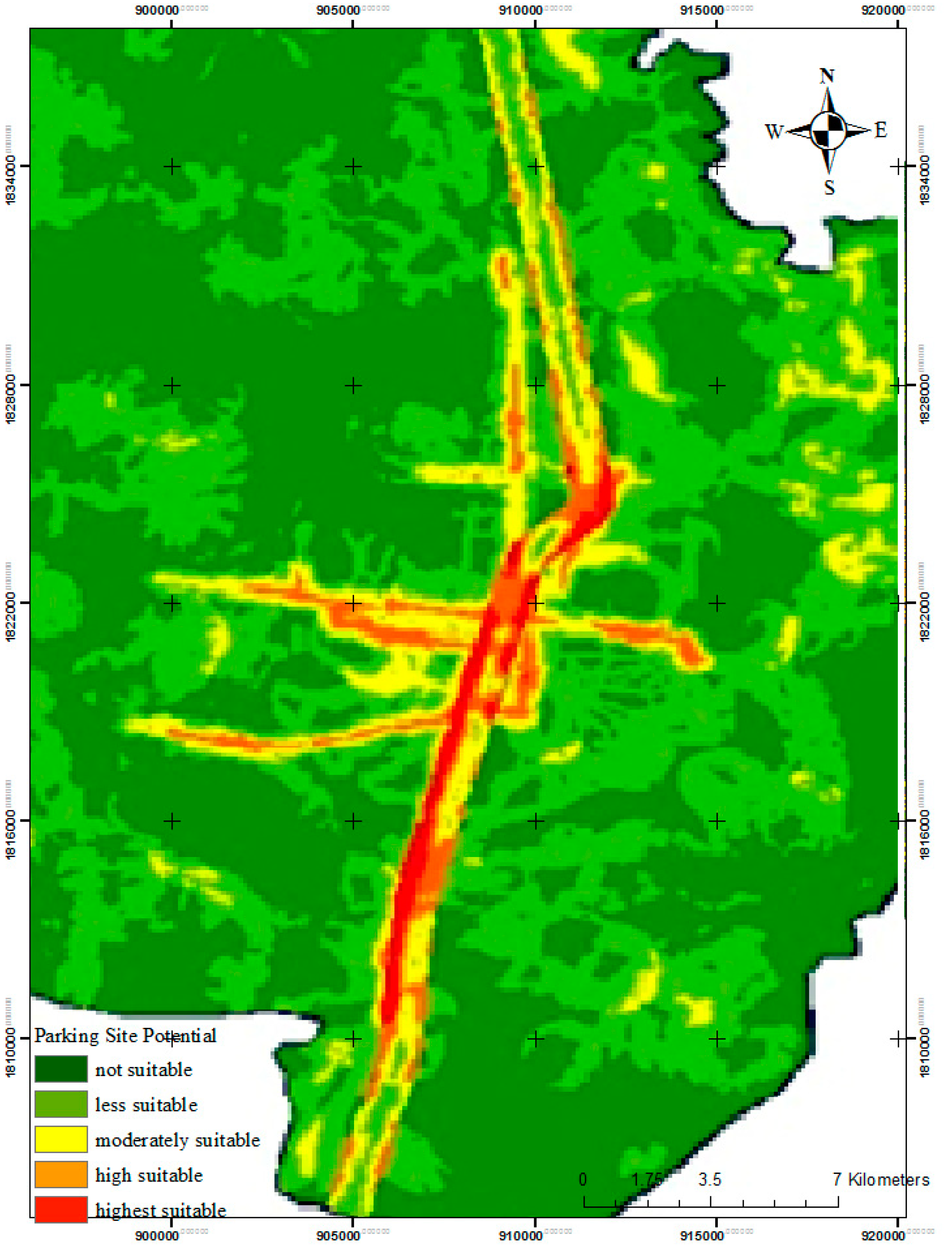
The present study had eight elements associated with decision criteria (n = 8). Accordingly, RI = 1.41 and CR = 0.14. The potentially suitable parking area was determined using AHP and SAW methods. Each criterion was processed by using GIS technique to prepare the map and determine the weighting from the AHP technique and rating scale, as shown in Table 7. An overlay analysis was applied to the map of potentially suitable parking areas, and the weights and rating scale of the sub criteria were calculated by the SAW method. The results of the SAW method were reclassified into five scales—not suitable, less suitable, moderately suitable, high suitable, and highest suitable—and are shown in Figure 1.
The results in Table 6 show that the most important criteria, according to the experts, for parking site suitability were rails and light rails, with weighting values of 0.27 and 0.21, respectively. Meanwhile, business land and governmental land were not very important, with values of 0.06 and 0.05, respectively. The difference between the weights of the rail and governmental land was 0.22. All of the criteria in Table 7 were defined in the GIS data layer and created the initial distance map. The weighted overlay function was applied to calculate the parking site suitability map with the weights of AHP and SAW following Equation (1).
The results of the parking site suitability map, shown in Figure 1, ranked rail, light rails, and road as highest suitable, high suitable, and moderately suitable, respectively. The results show that the most important suitability factor is that parking is within a distance of 300–600 m from the main road, light rails, and railway lines. In addition, suitable parking sites are located in the commercial area which surround the main road of the city.
4.2. Multi-Objective Decision Making for Selecting Parking Sites to Service the Light Rail Population using Fuzzy TOPSIS
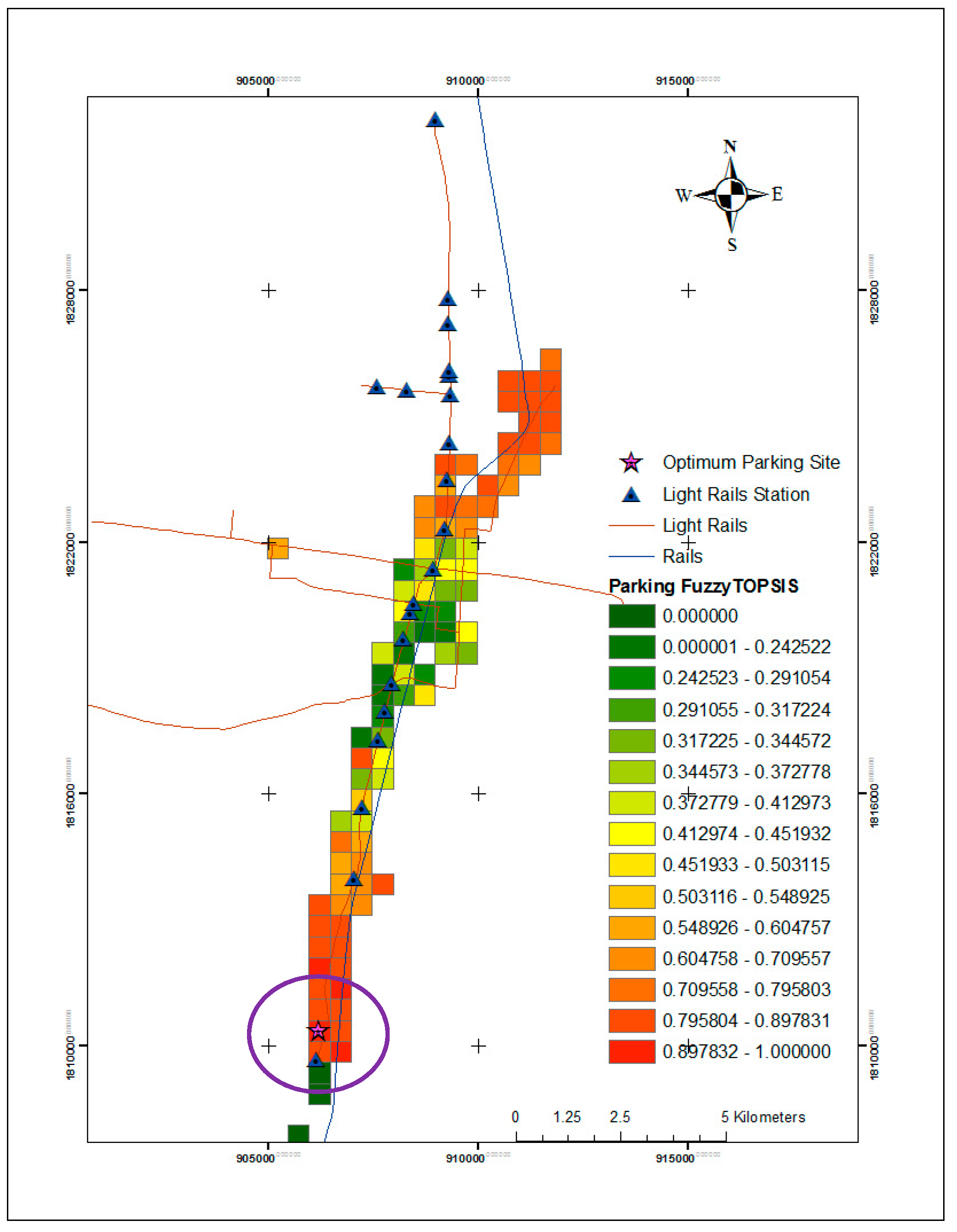
The highest-ranked potential parking sites were selected from the spatial grid cell results of the parking area using 500 m * 500 m fishnet grids. The scale parameters for parking site candidates were selected from the highest suitable among 94 site candidates, and the weights of each criterion were defined. Parameters were assigned a number based on the importance. The ideal solution and negative ideal are defined and described in Table 8. The fuzzy TOPSIS method was applied to the 94 site candidates by assigning linguistic variables for the weighting and ratings (scale parameters) from Table 3 and Table 4 with each criterion. The linguistic variables were C1(M), C2(ML), C3(MH), C4(H), and C5(MH), respectively. The fuzzy TOPSIS method was applied to solve the multi-objective decision of parking site selection for the service population. The results of the weighted normalized fuzzy decision matrix of the 20 site candidates and the fuzzy decision ideal best and fuzzy decision ideal worst values are shown in Table 9.
The distances of each candidate from the fuzzy positive ideal and fuzzy negative ideal are shown in Table 10 and Table 11. The relative closeness to the positive ideal solution and the top 20 best candidates in the parking site selection are shown in Table 12. The best candidates from the multi-objective decision-making method in selecting parking sites for the light rail station using fuzzy TOPSIS are shown in Figure 2.
Table 9 shows the results of the normalized fuzzy decision matrix with linguistic importance weights as well as fuzzy ideal best (v+) and ideal worst values (v−). The value of v+ shows that criteria C4 was higher than the others, and v− shows that criteria C2, C3, C4, and C5 had values of 0.00 in the fuzzy decision ideal worst. Table 10 shows that the distance from the fuzzy positive ideal point of criteria C4 was higher than that of the others. Additionally, in ranking the top 20 best candidates, the parking site criteria C4 was higher, as shown in Table 13. Table 11 and Table 13 show that the value of v− did not affect the distance, and the fuzzy negative ideal was 0.00.
Table 12 shows the relative closeness to the positive ideal solution of the best candidate parking sites. Figure 2 shows that the candidate parking site 91 was closest to the positive ideal solution. In the circle of Figure 2, the candidate parking site 91 was nearest to the light rail terminal (Tha Pha LRT Station).
5. Discussion
The results of the parking site selection based on MCDA and MODM were divided into two steps. First, the MCDA considered the suitable sites from the AHP technique and evaluated the weights of the eight criteria according to experts. The weights of the distance from the rail and the light rail were higher than the other criteria, showing that both are important in selecting the most suitable parking area. AHP weighting shows the difference between the importance of the rail and light railway with the business land was 0.22; thus, the parking site should be nearest the light rail or road and could reduce the time to get to the light rail station, and this finding was related with another study [26]. The result of the SAW shows that the most suitable area for parking is along the railway and light rail line. Moreover, most suitable areas were within the economic area or business land, which is an important factor to consider in choosing the best location to build parking areas; this finding is related to another study [44]. A walking distance of 300–600 m from the parking site to the light rail was considered the most suitable in this study; this is comparable to other findings [45] in Bangkok, Thailand, where this distance was around 400–800 m. Similarly, the acceptable walking distance in other comparable Asian countries was found to be 700–1250 m [46,47]. Therefore, highly suitable areas are near to the highest suitable area according to the distance from the railway and light rail line to the nearest highest suitable area. Accordingly, the weights of each criterion are important to the different outputs in selecting the most suitable parking distance.
The use of MODM as a fuzzy TOPSIS method in the parking site selection process allowed us to solve the multi-objective parking site selection problem. The method provides the possibility to select the best parking site by modifying the fuzzy TOPSIS with a ranked site selection based on the ideal point. The selection criteria are important in selecting the best site. The criteria considered in this research include the distances from the commercial center, railway, official governmental centers, light rail station, and educational and recreational centers, which were related to another study [25]. Use of linguistic variables for the weight and scale parameters of each criterion followed Chen’s approach [41]. The scale parameters of each criteria were evaluated by experts, and a score was assigned to the criteria according to candidate parking sites. The positive ideal solution used the maximum value from the experts’ scores, and the negative ideal used the minimum scale parameter. According to the results, the fuzzy positive ideal best solution for the distance from the light rail station was much higher compared to the other criteria, showing that the maximum value of the fuzzy decision ideal point was closest to the ideal solution. Different from this, the maximum value of the fuzzy decision ideal worst was affected by the distance of the ideal solution. Figure 2 shows that the most suitable candidate area for a parking site was located at site 91, which is located closest to the terminal light rail station (Tha Pha LRT Station). Additionally, this location is closest to Khon Kaen bus station 2 and closest to the business area. Consequently, the results show that fuzzy TOPSIS can determine the ideal solution. However, fuzzy TOPSIS can select the best parking site from a multi-objective decision standpoint, with the best site depending on the decision making.
6. Conclusions
The problem in multi-objective decision making is to select the best site or alternative. In general, there are three steps—step 1 is finding a suitable area using GIS, step 2 is selecting the candidate sites, and step 3 is selecting the best site. This research approach uses the techniques of MCDA and MODM to solve the problem of site selection. The AHP technique is widely used in applications to evaluate the weight of each criterion. The results of AHP and GIS techniques allow decision makers to select the areas in which there are highly suitable or poorly suitable candidate sites. This paper considers the distances of criteria, including rail, light rail, road, government land, and business land within 1000 m for use in the sub-criteria. The results showed the most suitable parking site was along the main road. The distance was within 1000 m, as related to the reduced time seen in another study [26], and the acceptable walking distance was similar to findings in other studies [45,46,47]. GIS and MCDA used the AHP method to determine the weighting of the criteria and are very important to determine suitable parking results. Consequently, expert opinions should be considered in research when determining the scale of pairwise comparisons.
In multi-objective problems for selecting the best of parking candidate sites by using fuzzy TOPSIS, a linguistic approach has been shown to help provide decisions in difficult cases. This paper set the parameters according to Chen [41], and the low linguistic variable weight was not determined, unlike the linguistic variable for rating equal importance (0;1;3). This paper found more than ratings of equal importance for the criteria C2, C3, C4, and C5, which means these four criteria are important in solving the solution. Results of the best candidate parking sites found that the fuzzy negative ideal point for the top 20 ranked criteria (C2, C3, C4, and C4) was 0.00. In conclusion, the maximum fuzzy decision ideal best (v+) and the minimum fuzzy decision ideal worst (v−) were suitable for selecting the most optimal parking site in this paper. However, the technique for solving the problem of site selection with multi-objective optimization should be studied in more detail, including evaluating other algorithm techniques such as genetics algorithm or particle swarm optimization.
Author Contributions
Conceptualization, S.S. and N.P.; Formal analysis, S.S. and N.P.; Investigation, S.S. and N.P.; Methodology, S.S.; Project administrator, S.S. and N.P.; Writing—original draft, S.S. and N.P.; and Writing—review and editing, S.S. and N.P. All authors have read and agreed to the published version of the manuscript.
Funding
This research project was financially supported by the Faculty of Informatics, Mahasarakham University, and the Research Unit of Geo-Informatics for Local Development.
Conflicts of Interest
The authors declare no conflicts of interest.
References
- Sriaram, K. Thailand Infrastructure News. Available online: https://www.pwc.com/th/en/deals/assets/infrastructure-news/Issue3.pdf (accessed on 14 November 2019).
- Khon Kaen City Development Co., LTD. Khon Kaen Smart City Project. Available online: https://www.khonkaenthinktank.com/project.php (accessed on 10 January 2020).
- Shah, J. Smart Parking Solution Making the Parking Impossible. Available online: https://www.letsnurture.com/blog/smart-parking-making-parking-im-possible.html (accessed on 15 January 2020).
- Kumar, K.; Kumanan, S. Decision Making in Location Selection: An Integrated Approach with Clustering and TOPSIS. IUP. J. Oper. Manag. 2012, 11, 7–20. [Google Scholar]
- Louviere, J.J.; Hensher, D.A.; Swait, J.D. Stated Choice Methods: Analysis and Applications; Cambridge University Press: Cambridge, UK, 2002. [Google Scholar]
- Riad, P.H.S.; Billib, M.; Hassan, A.A.; Salam, M.A.; Din, M.N.E. Application of The Overlay Weighted Model and Boolean Logic to Determine the Best Locations for Artificial Recharge of Groundwater. J. Urban. Environ. Eng. 2011, 5, 57–66. [Google Scholar] [CrossRef]
- Fei, X.; Gao, X.; Zhang, Z. Park site selection based on RS and GIS—A case study of Zaozhuang in Shandong province. In Proceedings of the 2009 Joint Urban Remote Sensing Event, Shanghai, China, 20–22 May 2009; pp. 1–5. [Google Scholar]
- Klapka, J.; Pinos, P. Decision support system for multicriterial R&D and information systems projects selection. Eur. J. Oper. Res. 2002, 140, 434–446. [Google Scholar]
- Abdullah, L.; Adawiyah, C.W.R. Simple Additive Weighting Methods of Multi Criteria Decision Making and Applications: A Decade Review. Int. J. Inform. Process. Manag. 2014, 5, 39–49. [Google Scholar]
- Afshari, A.; Mojahed, M.; Yusuff, R.M. Simple Additive Weighting approach to Personnel Selection problem. Int. J. Innov. Manag. Technol. 2010, 1, 511–515. [Google Scholar]
- Safavian, S.T.S.; Fataei, E.; Ebadi, T.; Mohamadian, A. Site Selection of Sarein’s Municipal Solid Waste Landfill Using the GIS Technique and SAW Method. Int. J. Environ. Sci. Dev. 2015, 6, 934–937. [Google Scholar] [CrossRef]
- Wang, J.J.; Jing, Y.Y.; Zhang, C.F.; Zhao, J.H. Review on multi-criteria decision analysis aid in sustainable energy decision-making. Renew. Sustain. Energy Rev. 2009, 13, 2263–2278. [Google Scholar] [CrossRef]
- Saaty, T.L. The Analytic Hierarchy Process; McGraw-Hill: New York, NY, USA, 1980. [Google Scholar]
- Ho, H.P.; Chang, C.T.; Ku, C.Y. On the Location Selection Problem using Analytic Hierarchy Process and Multi-choice Goal Programming. Int. J. Syst. Sci. 2013, 44, 94–108. [Google Scholar] [CrossRef]
- Lin, Y.H.; Lee, P.C.; Chang, T.P.; Ting, H.I. Multi-attribute Group Decision Making Model Under the Condition of Uncertain Information. Autom. Constr. 2008, 17, 792–797. [Google Scholar] [CrossRef]
- Van Laarhoven, P.J.M.; Pedrycz, W. A Fuzzy Extension of Saaty’s Priority Theory. Fuzzy Set. Syst. 1983, 11, 229–241. [Google Scholar] [CrossRef]
- Kahraman, C. Multi-Criteria Decision Making Methods and Fuzzy Sets; Springer Publishing Company: New York, NY, USA, 2008. [Google Scholar]
- Deb, K. Multi-Objective Optimization Using Evolutionary Algorithms: An Introduction; Jhon Wiley and Sons Ltd.: Hoboken, NJ, USA, 2001. [Google Scholar]
- Malczewski, J. GIS and Multicriteria Decision Analysis; Wiley: New York, NY, USA, 1999. [Google Scholar]
- Malczewski, J. GIS-based Multicriteria Decision Analysis: A Survey of the Literature. Int. J. Geogr. Inf. Sci. 2006, 20, 703–726. [Google Scholar] [CrossRef]
- Kulinich, I.; Lee, H. Parking Site Selection in Downtown of Khabarovsk City Using GIS. Int. J. Smart Home. 2016, 10, 15–24. [Google Scholar] [CrossRef]
- Karimi, V.; Ebadi, H.; Ahmadi, S. Public Parking Site Selection using GIS. In Proceedings of the Map World Forum, Hyderabad, India, 22–25 January 2007; p. 112. [Google Scholar]
- Farzanmanesh, R.; Naeeni, A.G.; Abdullah, A.M. Parking Site Selection Management using Fuzzy logic and Multi Criteria Decision Making. EnvironmentAsia 2010, 3, 109–116. [Google Scholar]
- Baseri, M.A.; Malekabadi, R.M.; Gandomkar, A. Site Selection of Public Parking in Isfahan City, using AHP Model. Int. J. Hum. Soc. Sci. 2012, 6, 547–550. [Google Scholar]
- Nazarboland, A.; Izadi, B. Site Selection for Public Parking in Shiraz City, (Case Study of District6 of Shiraz). J. Sci. Today World. 2014, 3, 358–369. [Google Scholar]
- Aliniai, K.; Yarahmadi, A.; Zarin, J.Z.; Yarahmadi, H.; Lak, S.B. Parking Lot Site Selection: An Opening Gate Towards Sustainable GIS-based Urban Traffic Management. J. Indian Soc. Remote Sens. 2015, 43, 801–813. [Google Scholar] [CrossRef]
- Jelokhani-Niaraki, M.; Malczewski, J. A Group Multicriteria Spatial Decision Support System for Parking Site Selection Problem: A Case Study. Land Use Policy 2015, 42, 492–508. [Google Scholar] [CrossRef]
- He, R.C.; Ma, C.X.; Li, Y.Z. Site Selection of Public Parking Lot in the New District. Int. J. Wire. Mob. Comp. 2015, 8, 147–152. [Google Scholar] [CrossRef]
- Current, J.; Min, H.; Schilling, D. Multiobjective Analysis of Facility Location Decisions. Eur. J. Oper. Res. 1990, 49, 295–307. [Google Scholar] [CrossRef]
- Hwang, C.L.; Yoon, K. Multiple Attribute Decision Making Methods and Applications a State of the Art Survey; Springer: New York, NY, USA, 1981. [Google Scholar]
- Krohling, R.A.; Pacheco, A.G.C. A-TOPSIS—An approach Based on TOPSIS for Ranking Evolutionary Algorithms. Procedia Comput. Sci. 2017, 55, 308–317. [Google Scholar] [CrossRef] [Green Version]
- Yoon, K.P.; Hwang, C.L. Multiple Attribute Decision Making an Introduction; Sage Publications: Thousand Oaks, CA, USA, 1995. [Google Scholar]
- Asadzadeh, A.; Sikder, S.K.; Mahmoudi, F.; Kotter, T. Assessing Site Selection of New Towns Using TOPSIS Method Under Entropy Logic: A Case Study: New Towns of Tehran Metropolitan Region (TMR). Environ. Manag. Sustain. Dev. 2014, 3, 123–137. [Google Scholar] [CrossRef] [Green Version]
- Roy, J.; Adhikary, K.; Kar, S. Credibilistic TOPSIS Model for Evaluation and Selection of Municipal Solid Waste Disposal Methods. Advances in Waste Management; Springer: Singapore, 2019. [Google Scholar]
- Chu, J.; Su, Y. The Application of TOPSIS Method in Selecting Fixed Seismic Shelter for Evacuation in Cities. Syst. Eng. Pro. 2012, 3, 391–397. [Google Scholar] [CrossRef] [Green Version]
- Naghdi, F.; Monavvari, S.M.; Hosseini, S.M.; Gharagozlu, A. Industrial Zone of East Azerbaijan Province of Iran using Multicriteria Evaluation Modeling. Appl. Ecol. Environ. Res. 2017, 15, 1565–1576. [Google Scholar] [CrossRef]
- Dhiman, H.S.; Deb, D.; Muresan, V.; Unguresan, M.L. Multi-Criteria Decision Making Approach for Hybrid Operation of Wind Farms. Symmetry 2019, 11, 675. [Google Scholar] [CrossRef] [Green Version]
- Wang, C.N.; Hsueh, M.H.; Lin, D.F. Hydrogen Power Plant Site Selection Under Fuzzy Multicriteria Decision-Making (FMCDM) Environment Conditions. Symmetry 2019, 11, 596. [Google Scholar] [CrossRef] [Green Version]
- Zeng, S.; Hussain, A.; Mahmood, T.; Irfan Ali, M.; Ashraf, S.; Munir, M. Covering-Based Spherical Fuzzy Rough Set Model Hybrid with TOPSIS for Multi-Attribute Decision-Making. Symmetry 2019, 11, 547. [Google Scholar] [CrossRef] [Green Version]
- Krohling, R.A.; Campanharo, V.C. Fuzzy TOPSIS for Group Decision Making: A Case Study for Accidents with Oil Spill in the Sea. Expert Syst. Appl. 2011, 38, 4190–4197. [Google Scholar] [CrossRef]
- Chen, C.T. Extension of the TOPSIS for Group Decision-making Under Fuzzy Environment. Fuzzy Set. Syst. 2000, 114, 1–9. [Google Scholar] [CrossRef]
- Yalçın, N.; Yapıcı Pehlivan, N. Application of the Fuzzy CODAS Method Based on Fuzzy Envelopes for Hesitant Fuzzy Linguistic Term Sets: A Case Study on a Personnel Selection Problem. Symmetry 2019, 11, 493. [Google Scholar] [CrossRef] [Green Version]
- Adeel, A.; Akram, M.; Koam, A.N.A. Group Decision-Making Based on m-Polar Fuzzy Linguistic TOPSIS Method. Symmetry 2019, 11, 735. [Google Scholar] [CrossRef] [Green Version]
- Kligman, R.; McDevitt, R.; Withee, T. Application of GIS to a Parking Study in Newton Sponsoring Agency: City of Newton Department of Public Works Engineering Division. Submitted to the Faculty of Worcester Polytechnique Institute. Available online: www.wpi.edu/~mrmed (accessed on 27 April 2020).
- Pongprasert, P.; Kubota, H. Why TOD Residents Still Use Car? Understanding the Factors Affecting the Automobile Ownership and Use of Residents Living Near Transit Stations of Bangkok. Urban Reg. Plan. Rev. 2017, 4, 231–250. [Google Scholar]
- Lee, K.I.; Kim, K.J.; Kwon, S.J. A Study on Characteristics of Subway Utilization and Pedestrians’ Accessibility at New Town in Korea. J. Asian Archit. Build. Eng. 2015, 4, 85–95. [Google Scholar] [CrossRef] [Green Version]
- Rastogi, R.; Krishna Rao, K.V. Travel Characteristics of Commuter Accessing Transit: Case Study. J. Transp. Eng. 2003, 129, 684–694. [Google Scholar] [CrossRef]
Figure 1.
Suitable parking map from multi-criteria decision analysis (MCDA).

Figure 2.
Parking site candidates map from fuzzy technique for order preference by similarity to ideal solution (TOPSIS).
Figure 2.
Parking site candidates map from fuzzy technique for order preference by similarity to ideal solution (TOPSIS).


Table 1.
Saaty 1–9 scale of pairwise comparisons.
| Intensity of Importance | Definition | Explanation |
|---|---|---|
| 1 | Equal Importance | Two activities contribute equally to the objective |
| 2 | Weak or Slight | |
| 3 | Moderate Importance | Experience and judgment slightly favor one activity over another |
| 4 | Moderate Plus | |
| 5 | Strong Importance | Experience and judgment strongly favor one activity over another |
| 6 | Strong Plus | |
| 7 | Very Strong | An activity is favored very strongly over another |
| 8 | Very, very Strong | |
| 9 | Extreme Importance | The evidence favoring one activity over another is of the highest possible order of affirmation |
Table 2.
The scale parameters of each criterion.
| Intensity of Importance | Definition | Explanation |
|---|---|---|
| 1 | Equal Importance | Two activities contribute equally to the objective |
| 3 | Moderate Importance | Experience and judgment slightly favor one activity over another |
| 5 | Strong Importance | Experience and judgment strongly favor one activity over another |
| 7 | Very Strong | An activity is favored very strongly over another |
| 9 | Extreme Importance | The evidence favoring one activity over another is of the highest possible order of affirmation |
Table 3.
Linguistic variables for the importance weight of each criterion.
| Definition | Linguistic Variables |
|---|---|
| Low (L) | (0; 0.1; 0.3) |
| Medium low | (0.1; 0.3; 0.5) |
| Medium (M) | (0.3; 0.5; 0.7) |
| Medium high | (0.5; 0.7; 0.9) |
| High (H) | (0.7; 0.9; 1.0) |
Table 4.
Linguistic variables for the ratings (scale parameters).
| Intensity of Importance | Definition | Linguistic Variables |
|---|---|---|
| 1 | Equal Importance | (0;1;3) |
| 3 | Moderate Importance | (1;3;5) |
| 5 | Strong Importance | (3; 5; 7) |
| 7 | Very Strong | (5; 7; 9) |
| 9 | Extreme Importance | (7; 9; 10) |
Table 5.
Pairwise comparison matrix and eigenvector values.
| Criteria | C1 | C2 | C3 | C4 | C5 | C6 | C7 | C8 | SUM | Eigenvalues |
|---|---|---|---|---|---|---|---|---|---|---|
| C1 | 0.28 | 0.65 | 0.51 | 0.38 | 0.32 | 0.22 | 0.1 | 0.12 | 2.58 | 9.21 |
| C2 | 0.09 | 0.22 | 0.51 | 0.19 | 0.43 | 0.22 | 0.16 | 0.24 | 2.05 | 9.48 |
| C3 | 0.09 | 0.05 | 0.17 | 0.19 | 0.43 | 0.22 | 0.21 | 0.18 | 1.54 | 9.17 |
| C4 | 0.07 | 0.11 | 0.08 | 0.09 | 0.04 | 0.3 | 0.1 | 0.06 | 0.85 | 9.06 |
| C5 | 0.09 | 0.05 | 0.04 | 0.03 | 0.11 | 0.22 | 0.21 | 0.18 | 0.94 | 8.72 |
| C6 | 0.09 | 0.07 | 0.06 | 0.02 | 0.04 | 0.07 | 0.16 | 0.12 | 0.63 | 8.48 |
| C7 | 0.06 | 0.07 | 0.04 | 0.05 | 0.03 | 0.02 | 0.05 | 0.12 | 0.44 | 8.4 |
| C8 | 0.14 | 0.04 | 0.06 | 0.09 | 0.04 | 0.04 | 0.03 | 0.06 | 0.49 | 8.33 |
Table 6.
Criteria weights using the analytic hierarchy process (AHP) method.
| Criteria | Weight |
|---|---|
| rails | 0.27 |
| light rails | 0.21 |
| urban | 0.18 |
| road | 0.10 |
| water bodies | 0.08 |
| land use | 0.07 |
| business land | 0.06 |
| governmental land | 0.05 |
Maximum Eigenvalue (λmax) =8.86. N = 8. Consistency index (CI) = (λmax − n)/(n − 1) = 0.21. Random index (RI) = 1.41. Consistency ratio (CR) = (CI/RI) = 0.14.
Table 7.
Main criteria weights and sub criteria rating scores.
| Criteria | Weighting (AHP) | Rating Scale of Sub Criteria | |
|---|---|---|---|
| Description of Sub Criteria | Rating Score | ||
| rails | 0.27 | Distance ≤200 m | 1 |
| Distance ≤400 m | 2 | ||
| Distance ≤600 m | 3 | ||
| Distance ≤800 m | 4 | ||
| Distance ≤1000 m | 5 | ||
| light rails | 0.21 | Distance ≤200 m | 5 |
| Distance ≤400 m | 4 | ||
| Distance ≤600 m | 3 | ||
| Distance ≤800 m | 2 | ||
| Distance ≤1000 m | 1 | ||
| urban | 0.18 | Distance ≤500 m | 5 |
| Distance ≤1000 m | 4 | ||
| Distance ≤1500 m | 3 | ||
| Distance ≤2000 m | 2 | ||
| Distance ≤2500 m | 1 | ||
| road | 0.1 | Distance ≤200 m | 5 |
| Distance ≤400 m | 4 | ||
| Distance ≤600 m | 3 | ||
| Distance ≤800 m | 2 | ||
| Distance ≤1000 m | 1 | ||
| water bodies | 0.08 | Distance ≤200 m | 1 |
| Distance ≤400 m | 2 | ||
| Distance ≤600 m | 3 | ||
| Distance ≤800 m | 4 | ||
| Distance ≤1000 m | 5 | ||
| land use | 0.07 | miscellaneous | 3 |
| Green space | 4 | ||
| Bare land | 5 | ||
| business land | 0.06 | Distance ≤200 m | 5 |
| Distance ≤400 m | 4 | ||
| Distance ≤600 m | 3 | ||
| Distance ≤800 m | 2 | ||
| Distance ≤1000 m | 1 | ||
| governmental land | 0.05 | Distance ≤200 m | 5 |
| Distance ≤400 m | 4 | ||
| Distance ≤600 m | 3 | ||
| Distance ≤800 m | 2 | ||
| Distance ≤1000 m | 1 | ||
Table 8.
The ideal solution and negative ideal criteria.
| Criteria | Positive Ideal | Negative Ideal |
|---|---|---|
| C1: Distance from the commercial centers | Maximum | Minimum |
| C2: Distance from the railway | Maximum | Minimum |
| C3: Distance from the official governmental centers. | Maximum | Minimum |
| C4: Distance from the light rail station. | Maximum | Minimum |
| C5: Distance from educational and recreational centers | Maximum | Minimum |
Table 9.
Results of weighted normalized fuzzy decision matrix.
| Site | Weight (C1) | Weight (C2) | Weight (C3) | Weight (C4) | Weight (C5) | ||||||||||
|---|---|---|---|---|---|---|---|---|---|---|---|---|---|---|---|
| 0.3 | 0.5 | 0.7 | 0.1 | 0.3 | 0.5 | 0.5 | 0.7 | 0.9 | 0.7 | 0.9 | 1 | 0.5 | 0.7 | 0.9 | |
| C1 | C2 | C3 | C4 | C5 | |||||||||||
| 1 | 0.00 | 0.05 | 0.21 | 0.00 | 0.03 | 0.15 | 0.00 | 0.07 | 0.27 | 0.00 | 0.09 | 0.30 | 0.00 | 0.07 | 0.27 |
| 2 | 0.09 | 0.25 | 0.49 | 0.05 | 0.21 | 0.45 | 0.15 | 0.35 | 0.63 | 0.00 | 0.09 | 0.30 | 0.25 | 0.49 | 0.81 |
| 3 | 0.15 | 0.35 | 0.63 | 0.07 | 0.27 | 0.50 | 0.25 | 0.49 | 0.81 | 0.00 | 0.09 | 0.30 | 0.35 | 0.63 | 0.90 |
| 4 | 0.21 | 0.45 | 0.70 | 0.03 | 0.15 | 0.35 | 0.35 | 0.63 | 0.90 | 0.00 | 0.09 | 0.30 | 0.15 | 0.35 | 0.63 |
| 5 | 0.15 | 0.35 | 0.63 | 0.03 | 0.15 | 0.35 | 0.15 | 0.35 | 0.63 | 0.00 | 0.09 | 0.30 | 0.15 | 0.35 | 0.63 |
| 6 | 0.21 | 0.45 | 0.70 | 0.00 | 0.03 | 0.15 | 0.15 | 0.35 | 0.63 | 0.00 | 0.09 | 0.30 | 0.00 | 0.07 | 0.27 |
| 7 | 0.15 | 0.35 | 0.63 | 0.00 | 0.03 | 0.15 | 0.05 | 0.21 | 0.45 | 0.00 | 0.09 | 0.30 | 0.00 | 0.07 | 0.27 |
| 8 | 0.21 | 0.45 | 0.70 | 0.00 | 0.03 | 0.15 | 0.00 | 0.07 | 0.27 | 0.00 | 0.09 | 0.30 | 0.00 | 0.07 | 0.27 |
| 9 | 0.15 | 0.35 | 0.63 | 0.00 | 0.03 | 0.15 | 0.00 | 0.07 | 0.27 | 0.00 | 0.09 | 0.30 | 0.00 | 0.07 | 0.27 |
| 10 | 0.21 | 0.45 | 0.70 | 0.00 | 0.03 | 0.15 | 0.00 | 0.07 | 0.27 | 0.00 | 0.09 | 0.30 | 0.00 | 0.07 | 0.27 |
| 11 | 0.15 | 0.35 | 0.63 | 0.00 | 0.03 | 0.15 | 0.00 | 0.07 | 0.27 | 0.00 | 0.09 | 0.30 | 0.00 | 0.07 | 0.27 |
| 12 | 0.21 | 0.45 | 0.70 | 0.00 | 0.03 | 0.15 | 0.00 | 0.07 | 0.27 | 0.00 | 0.09 | 0.30 | 0.00 | 0.07 | 0.27 |
| 13 | 0.21 | 0.45 | 0.70 | 0.00 | 0.03 | 0.15 | 0.00 | 0.07 | 0.27 | 0.00 | 0.09 | 0.30 | 0.00 | 0.07 | 0.27 |
| 14 | 0.15 | 0.35 | 0.63 | 0.00 | 0.03 | 0.15 | 0.00 | 0.07 | 0.27 | 0.00 | 0.09 | 0.30 | 0.00 | 0.07 | 0.27 |
| 15 | 0.21 | 0.45 | 0.70 | 0.00 | 0.03 | 0.15 | 0.00 | 0.07 | 0.27 | 0.00 | 0.09 | 0.30 | 0.00 | 0.07 | 0.27 |
| 16 | 0.15 | 0.35 | 0.63 | 0.00 | 0.03 | 0.15 | 0.00 | 0.07 | 0.27 | 0.00 | 0.09 | 0.30 | 0.00 | 0.07 | 0.27 |
| 17 | 0.21 | 0.45 | 0.70 | 0.00 | 0.03 | 0.15 | 0.05 | 0.21 | 0.45 | 0.00 | 0.09 | 0.30 | 0.00 | 0.07 | 0.27 |
| 18 | 0.15 | 0.35 | 0.63 | 0.00 | 0.03 | 0.15 | 0.05 | 0.21 | 0.45 | 0.00 | 0.09 | 0.30 | 0.00 | 0.07 | 0.27 |
| 19 | 0.21 | 0.45 | 0.70 | 0.00 | 0.03 | 0.15 | 0.15 | 0.35 | 0.63 | 0.00 | 0.09 | 0.30 | 0.00 | 0.07 | 0.27 |
| 20 | 0.15 | 0.35 | 0.63 | 0.00 | 0.03 | 0.15 | 0.15 | 0.35 | 0.63 | 0.00 | 0.09 | 0.30 | 0.00 | 0.07 | 0.27 |
| v+ | 0.21 | 0.45 | 0.7 | 0.07 | 0.27 | 0.5 | 0.35 | 0.63 | 0.9 | 0.49 | 0.81 | 1 | 0.35 | 0.63 | 0.9 |
| v− | 0.03 | 0.15 | 0.35 | 0 | 0.03 | 0.15 | 0 | 0.07 | 0.27 | 0 | 0.09 | 0.3 | 0 | 0.07 | 0.27 |
Table 10.
Results of euclidean distance from the fuzzy positive ideal best.
| Site | C1 | C2 | C3 | C4 | C5 | S+ |
|---|---|---|---|---|---|---|
| 1 | 0.385 | 0.248 | 0.527 | 0.645 | 0.350 | 2.155 |
| 2 | 0.181 | 0.047 | 0.253 | 0.645 | 0.100 | 1.225 |
| 3 | 0.079 | 0.000 | 0.112 | 0.645 | 0.000 | 0.836 |
| 4 | 0.000 | 0.113 | 0.000 | 0.645 | 0.200 | 0.958 |
| 5 | 0.079 | 0.113 | 0.253 | 0.645 | 0.200 | 1.289 |
| 6 | 0.000 | 0.248 | 0.253 | 0.645 | 0.350 | 1.496 |
| 7 | 0.079 | 0.248 | 0.395 | 0.645 | 0.350 | 1.717 |
| 8 | 0.000 | 0.248 | 0.527 | 0.645 | 0.350 | 1.770 |
| 9 | 0.079 | 0.248 | 0.527 | 0.645 | 0.350 | 1.849 |
| 10 | 0.000 | 0.248 | 0.527 | 0.645 | 0.350 | 1.770 |
| 11 | 0.079 | 0.248 | 0.527 | 0.645 | 0.350 | 1.849 |
| 12 | 0.000 | 0.248 | 0.527 | 0.645 | 0.350 | 1.770 |
| 13 | 0.000 | 0.248 | 0.527 | 0.645 | 0.350 | 1.770 |
| 14 | 0.079 | 0.248 | 0.527 | 0.645 | 0.350 | 1.849 |
| 15 | 0.000 | 0.248 | 0.527 | 0.645 | 0.350 | 1.770 |
| 16 | 0.079 | 0.248 | 0.527 | 0.645 | 0.350 | 1.849 |
| 17 | 0.000 | 0.248 | 0.395 | 0.645 | 0.350 | 1.639 |
| 18 | 0.079 | 0.248 | 0.395 | 0.645 | 0.350 | 1.717 |
| 19 | 0.000 | 0.248 | 0.253 | 0.645 | 0.350 | 1.496 |
| 20 | 0.079 | 0.248 | 0.253 | 0.645 | 0.350 | 1.574 |
Table 11.
Results of Euclidean distance from the fuzzy negative ideal point.
| Site | C1 | C2 | C3 | C4 | C5 | S− |
|---|---|---|---|---|---|---|
| 1 | 0.101 | 0.000 | 0.000 | 0.000 | 0.000 | 0.101 |
| 2 | 0.105 | 0.204 | 0.277 | 0.000 | 0.421 | 1.007 |
| 3 | 0.210 | 0.248 | 0.421 | 0.000 | 0.527 | 1.406 |
| 4 | 0.286 | 0.136 | 0.527 | 0.000 | 0.277 | 1.226 |
| 5 | 0.210 | 0.136 | 0.277 | 0.000 | 0.277 | 0.901 |
| 6 | 0.286 | 0.000 | 0.277 | 0.000 | 0.000 | 0.563 |
| 7 | 0.210 | 0.000 | 0.135 | 0.000 | 0.000 | 0.345 |
| 8 | 0.286 | 0.000 | 0.000 | 0.000 | 0.000 | 0.286 |
| 9 | 0.210 | 0.000 | 0.000 | 0.000 | 0.000 | 0.210 |
| 10 | 0.286 | 0.000 | 0.000 | 0.000 | 0.000 | 0.286 |
| 11 | 0.210 | 0.000 | 0.000 | 0.000 | 0.000 | 0.210 |
| 12 | 0.286 | 0.000 | 0.000 | 0.000 | 0.000 | 0.286 |
| 13 | 0.286 | 0.000 | 0.000 | 0.000 | 0.000 | 0.286 |
| 14 | 0.210 | 0.000 | 0.000 | 0.000 | 0.000 | 0.210 |
| 15 | 0.286 | 0.000 | 0.000 | 0.000 | 0.000 | 0.286 |
| 16 | 0.210 | 0.000 | 0.000 | 0.000 | 0.000 | 0.210 |
| 17 | 0.286 | 0.000 | 0.135 | 0.000 | 0.000 | 0.420 |
| 18 | 0.210 | 0.000 | 0.135 | 0.000 | 0.000 | 0.345 |
| 19 | 0.286 | 0.000 | 0.277 | 0.000 | 0.000 | 0.563 |
| 20 | 0.210 | 0.000 | 0.277 | 0.000 | 0.000 | 0.488 |
Table 12.
Results of relative the closeness to the positive ideal solution and the top 20 best candidate parking sites.
Table 12.
Results of relative the closeness to the positive ideal solution and the top 20 best candidate parking sites.
| Site | S+ | S− | C+− |
|---|---|---|---|
| 91 | 2.056094 | 0 | 1 |
| 1 | 2.155173 | 0.10083 | 0.955306 |
| 85 | 1.951578 | 0.105198 | 0.948853 |
| 88 | 1.951578 | 0.105198 | 0.948853 |
| 94 | 1.951578 | 0.105198 | 0.948853 |
| 9 | 1.848907 | 0.210396 | 0.897831 |
| 11 | 1.848907 | 0.210396 | 0.897831 |
| 14 | 1.848907 | 0.210396 | 0.897831 |
| 16 | 1.848907 | 0.210396 | 0.897831 |
| 82 | 1.848907 | 0.210396 | 0.897831 |
| 87 | 1.848907 | 0.210396 | 0.897831 |
| 92 | 1.848907 | 0.210396 | 0.897831 |
| 8 | 1.770378 | 0.285715 | 0.86104 |
| 10 | 1.770378 | 0.285715 | 0.86104 |
| 12 | 1.770378 | 0.285715 | 0.86104 |
| 13 | 1.770378 | 0.285715 | 0.86104 |
| 15 | 1.770378 | 0.285715 | 0.86104 |
| 64 | 1.770378 | 0.285715 | 0.86104 |
| 78 | 1.770378 | 0.285715 | 0.86104 |
| 81 | 1.770378 | 0.285715 | 0.86104 |
Table 13.
Top 20 Euclidean distances from the fuzzy positive ideal best and fuzzy negative ideal wort.
Table 13.
Top 20 Euclidean distances from the fuzzy positive ideal best and fuzzy negative ideal wort.
| Site | Fuzzy Positive Ideal Best | Fuzzy Negative Ideal Point | ||||||||||
|---|---|---|---|---|---|---|---|---|---|---|---|---|
| C1 | C2 | C3 | C4 | C5 | S+ | C1 | C2 | C3 | C4 | C5 | S− | |
| 91 | 0.286 | 0.248 | 0.527 | 0.645 | 0.350 | 2.056 | 0.000 | 0.00 | 0.00 | 0.00 | 0.00 | 0.00 |
| 1 | 0.385 | 0.248 | 0.527 | 0.645 | 0.350 | 2.155 | 0.101 | 0.000 | 0.000 | 0.000 | 0.000 | 0.101 |
| 85 | 0.181 | 0.248 | 0.527 | 0.645 | 0.350 | 1.952 | 0.105 | 0.000 | 0.000 | 0.000 | 0.000 | 0.105 |
| 88 | 0.181 | 0.248 | 0.527 | 0.645 | 0.350 | 1.952 | 0.105 | 0.000 | 0.000 | 0.000 | 0.000 | 0.105 |
| 94 | 0.181 | 0.248 | 0.527 | 0.645 | 0.350 | 1.952 | 0.105 | 0.000 | 0.000 | 0.000 | 0.000 | 0.105 |
| 9 | 0.079 | 0.248 | 0.527 | 0.645 | 0.350 | 1.849 | 0.210 | 0.000 | 0.000 | 0.000 | 0.000 | 0.210 |
| 11 | 0.079 | 0.248 | 0.527 | 0.645 | 0.350 | 1.849 | 0.210 | 0.000 | 0.000 | 0.000 | 0.000 | 0.210 |
| 14 | 0.079 | 0.248 | 0.527 | 0.645 | 0.350 | 1.849 | 0.210 | 0.000 | 0.000 | 0.000 | 0.000 | 0.210 |
| 16 | 0.079 | 0.248 | 0.527 | 0.645 | 0.350 | 1.849 | 0.210 | 0.000 | 0.000 | 0.000 | 0.000 | 0.210 |
| 82 | 0.079 | 0.248 | 0.527 | 0.645 | 0.350 | 1.849 | 0.210 | 0.000 | 0.000 | 0.000 | 0.000 | 0.210 |
| 87 | 0.079 | 0.248 | 0.527 | 0.645 | 0.350 | 1.849 | 0.210 | 0.000 | 0.000 | 0.000 | 0.000 | 0.210 |
| 92 | 0.079 | 0.248 | 0.527 | 0.645 | 0.350 | 1.849 | 0.210 | 0.000 | 0.000 | 0.000 | 0.000 | 0.210 |
| 8 | 0.000 | 0.248 | 0.527 | 0.645 | 0.350 | 1.770 | 0.286 | 0.000 | 0.000 | 0.000 | 0.000 | 0.286 |
| 10 | 0.000 | 0.248 | 0.527 | 0.645 | 0.350 | 1.770 | 0.286 | 0.000 | 0.000 | 0.000 | 0.000 | 0.286 |
| 12 | 0.000 | 0.248 | 0.527 | 0.645 | 0.350 | 1.770 | 0.286 | 0.000 | 0.000 | 0.000 | 0.000 | 0.286 |
| 13 | 0.000 | 0.248 | 0.527 | 0.645 | 0.350 | 1.770 | 0.286 | 0.000 | 0.000 | 0.000 | 0.000 | 0.286 |
| 15 | 0.000 | 0.248 | 0.527 | 0.645 | 0.350 | 1.770 | 0.286 | 0.000 | 0.000 | 0.000 | 0.000 | 0.286 |
| 64 | 0.000 | 0.248 | 0.527 | 0.645 | 0.350 | 1.770 | 0.286 | 0.000 | 0.000 | 0.000 | 0.000 | 0.286 |
| 78 | 0.000 | 0.248 | 0.527 | 0.645 | 0.350 | 1.770 | 0.286 | 0.000 | 0.000 | 0.000 | 0.000 | 0.286 |
| 81 | 0.000 | 0.248 | 0.527 | 0.645 | 0.350 | 1.770 | 0.286 | 0.000 | 0.000 | 0.000 | 0.000 | 0.286 |
© 2020 by the authors. Licensee MDPI, Basel, Switzerland. This article is an open access article distributed under the terms and conditions of the Creative Commons Attribution (CC BY) license (http://creativecommons.org/licenses/by/4.0/).
Share and Cite
MDPI and ACS Style
Prasertsri, N.; Sangpradid, S. Parking Site Selection for Light Rail Stations in Muaeng District, Khon Kaen, Thailand. Symmetry 2020, 12, 1055. https://0-doi-org.brum.beds.ac.uk/10.3390/sym12061055
AMA Style
Prasertsri N, Sangpradid S. Parking Site Selection for Light Rail Stations in Muaeng District, Khon Kaen, Thailand. Symmetry. 2020; 12(6):1055. https://0-doi-org.brum.beds.ac.uk/10.3390/sym12061055
Chicago/Turabian StylePrasertsri, Narueset, and Satith Sangpradid. 2020. "Parking Site Selection for Light Rail Stations in Muaeng District, Khon Kaen, Thailand" Symmetry 12, no. 6: 1055. https://0-doi-org.brum.beds.ac.uk/10.3390/sym12061055
Note that from the first issue of 2016, this journal uses article numbers instead of page numbers. See further details here.