
VR and AR Restoration of Urban Heritage: A Virtual Platform Mediating Disagreement from Spatial Conflicts in Korea

Department of Architecture, College of Engineering, Korea University, Seoul 02855, Korea
*
Authors to whom correspondence should be addressed.
Buildings 2021, 11(11), 561; https://0-doi-org.brum.beds.ac.uk/10.3390/buildings11110561
Submission received: 13 October 2021
/
Revised: 7 November 2021
/
Accepted: 16 November 2021
/
Published: 20 November 2021
(This article belongs to the Section Architectural Design, Urban Science, and Real Estate)
Abstract
:This study sought to uncover (1) the disagreement of spatial conflict between urban heritage and surrounding urban structure using two case studies from Korea—the main gate of the royal palace (Gwanghwamun) and the urban park containing celebrity graves (Hyoch’ang Park)—and (2) whether digital heritage restoration may mediate spatial conflict. A historical literature review and field surveys were conducted, with three main findings. First, the place identity of Gwanghwamun and Hyoch’ang Park, rooted in the Josŏn Dynasty, was seriously damaged during the Japanese colonial period. Although there were national attempts to recover the place identities of these sites during the modern period, limitations existed. Second, the restoration of Gwanghwamun’s Wŏltae (podium) and the relocation of Ŭiyŏlsa (the shrine of Hyoch’ang Park), which involved spatial transformation based on heritage, emerged in conflict with their surrounding urban structures—we identify a spatial conflict between local residents and stakeholders’ memories and the histories of these sites. Third, Donŭimun (the west gate of the city wall of the Josŏn Dynasty) digital restoration is a case mediating the conflict by restoring a sense of place in a virtual space and activating the cultural memory of the public by showcasing properties.
1. Introduction
The spatial restructuring process of heritage sites can create conflict situations. Uriely et al. (2002) introduced the concept of “heritage proximity” based on the term “spatial proximity” (borrowed from geographers) and analyzed whether this could be considered one of the factors determining resident attitudes towards site development. [1]. Bloch (2016) examined the conflict by exploring how local residents were defined as “illegal encroachers” during the spatial cleanup of the Indian village of Hampi, a World Heritage site. [2]. Bertram (2018) analyzed the goals and motives pursued by various actors related to the strategies used to redevelop historic sites in Belfast’s roads and parks [3]. In other words, the spatial confrontation between heritage and the existing urban structure and the clash of opinions of various stakeholders are potential risks that can always exist. To deal with these problems, some researchers explore how policy is related to the coexistence of urban development and heritage and consider problematic approaches to their relationship. Gillespie (2012) argued that a standardized policy approach in spatial conflict is not a solution to the problem based on the principle of setting a core and buffer zone for World Heritage sites [4]. Janssen et al. (2014) criticized the separation of heritage conservation and urban planning and analyzed the Belvedere Memorandum and Incentive Program (1999–2009), in which the Dutch government actively encouraged the integration of the two, actively responding to spatial challenges and emphasizing relationship-building with actors [5]. Meanwhile, Rzasa et al. (2016) addressed the issues of cultural heritage in relation to the spatial planning system in Poland. The legal bases for the protection of monuments and their compounds are discussed along with the statutory requirements for space planning [6]. Nevertheless, it is difficult to fundamentally reconcile differences of opinion through these institutional and mediating approaches. This is because conflicts related to heritage within the city and surrounding development are extremely territorial issues.
The phenomenon of conflict, as observed above, in the reconstruction of a heritage site in a city has also occurred in Korea after the 21st century. The preservation and utilization of a historical site in old downtown became one of the key themes of regional reactivation in Korea [7]. Since the 2000s, there has been a government-led movement in Seoul, the capital of Korea, to restructure the old downtown area in a way that maintains its historical and cultural value; put differently, the movement is heavily focused on spot-lighting the urban heritage. More specifically, the movement seeks to develop the space in a way that reinforces national identity and symbolism and makes room for public spaces for leisure. In the 2010s, urban regeneration legislations were enacted in Korea, and urban regeneration and heritage are now linked through related systems. Various case studies on urban regeneration have focused on the positive effects utilizing historical and cultural resources in Korea [8,9,10,11,12,13,14,15]. However, attempts to expand and restore the original value and form of urban heritage sites inevitably lead to spatial conflicts with the surrounding urban structure, which has often been developed in a direction that is contrary to the preservation of the urban heritage. Especially, Seoul has undergone a rapid urbanization process due to an explosive population increase over the past few decades, and this speed of urban development has proven antagonistic to considerations of historical and cultural resources. Despite the existence of numerous urban heritage sites in Seoul—the capital of the Chosŏn dynasty for 500 years—urban planning and infrastructure construction in the city were not based on an understanding of history or culture, but on thorough economic logic. Under the fundamental limits of the city, the development around the heritage contains potential spatial conflict, which is revealed as a disagreement of the stakeholders in the process. Moreover, such restorations involve practical difficulties; they must grapple with many constraints related to the historical, social, technical, and urban design aspects of restoration [16].
Thus, this research examines the aspects of spatial conflict and disagreement between urban heritage sites and the surrounding urban structure revealed during the restructuring and attempts to uncover the reason why the conflict is difficult to resolve within the physical space. Further, we analyze whether digital restoration in virtual space can mediate the spatial conflict. To be specific, the study investigates the spatial conflicts that appear in the relationships between the restoration of the podium of the royal palace and the front road, as well as the relocation of the shrine and the stadium in front of it. Based on this, we discuss that virtual reality (VR) and augmented reality (AR) restorations of urban heritage may serve as a virtual platform alleviating conflict situations.
2. Materials and Methods
2.1. Materials
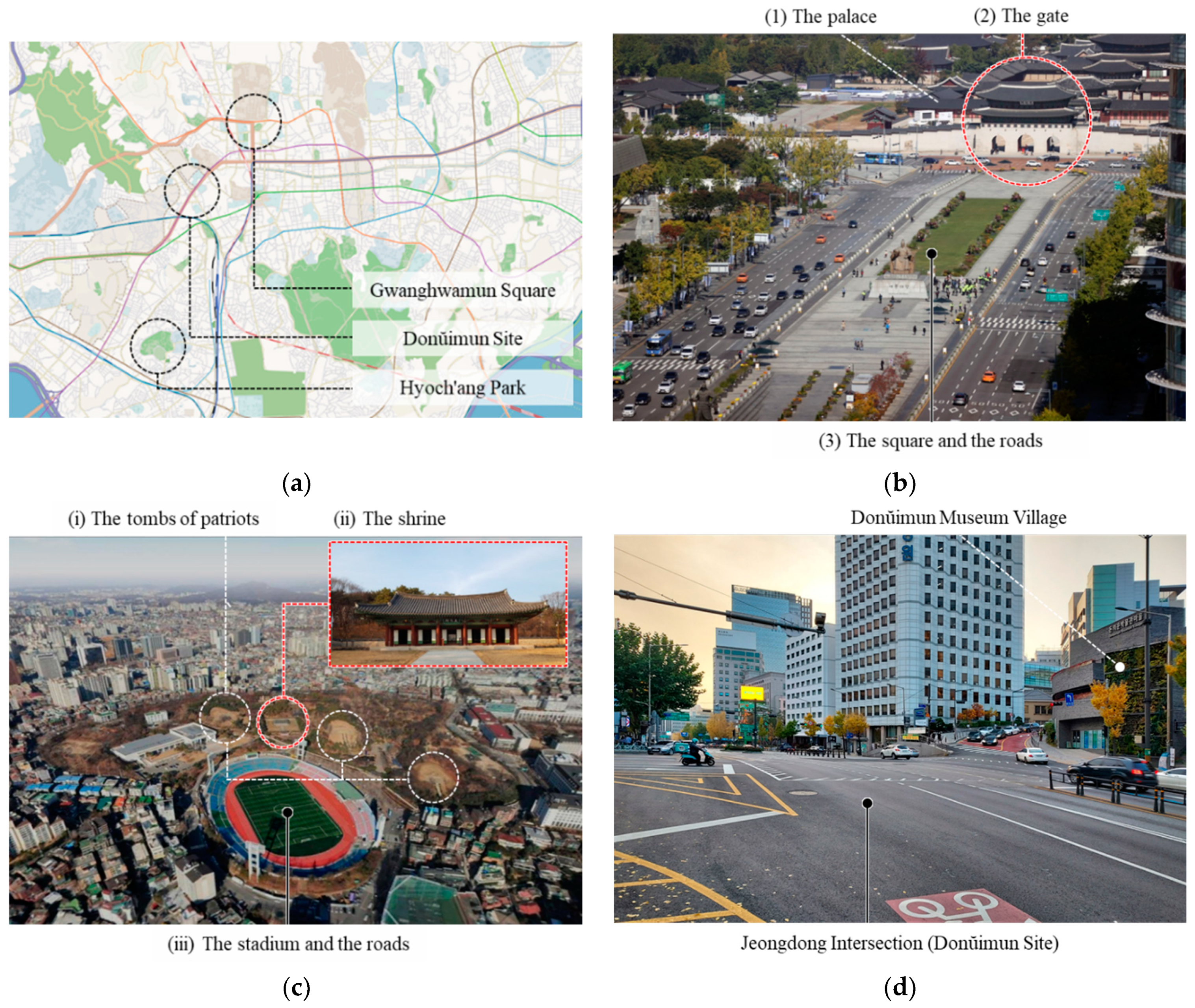
Gwanghwamun Square, Hyoch’ang Park and Donŭimun Site in Seoul are research cases (Figure 1a). Previous research has examined the design process and spatial change of Gwanghwamun Square [17,18] and the historical and spatial significances of Hyoch’ang Park and Donŭimun [19,20,21]. This study, however, traces the history of each heritage site, focusing on its specific architectural and spatial elements. We also focus on the spatial conflicts occurring in these heritage sites. Gwanghwamun Square is located in the heart of the old downtown of Seoul. In the Chosŏn Dynasty (1392–1910), it was the main road in front of the royal palace, and it was a place where major facilities of the country were concentrated. (1) The palace, Gyeongbokgung (Republic of Korea Historic Site No. 117), is now a representative tourist attraction in Seoul and was designated as a national cultural property in 1963. (2) The main gate of the palace is called Gwanghwamun. In front of the gate there is (3) a square and roads. Around the roads, major present-day government offices are located, and in the middle of the roads a plaza was created like an island in 2009 (Figure 1b). The rectangular square has an area of 18,840 m2. Hyoch’ang Park (Republic of Korea Historic Site No. 330) is an urban park in Seoul, 3.5 km southwest of Gwanghwamun Square, and has an area of 123,307 m2. It was originally a tomb for royalty during the Chosŏn Dynasty, but after the Japanese colonial period ended, (i) tombs for independence activists were formed in the 1940s. In recognition of its value, it was designated as a national cultural property in 1989 and (ii) a shrine was also installed at this time. After liberation, the landscaping of this park has been steadily progressing as an urban park, and (iii) a soccer stadium was built in the 1960s (Figure 1c). Hanyang was the name of Seoul during the Chosŏn Dynasty. Hanyang was a walled city, and Donŭimun was the western gate among the four main gates that entered and exited the fortress. It was located 1 km southwest of the present Gwanghwamun Square. Unlike Gwanghwamun and Hyoch’ang Park, Donŭimun is an urban heritage that has completely disappeared. The gate was destroyed by Japan in 1915. At the site of the gate, a 10-lane road called Jeongdong Intersection is now formed. Donŭimun Museum Village, which opened in 2017, shows the gate in VR and AR. (Figure 1d).
2.2. Methods
As a case study, we executed a historical literature review and field surveys, including participation in public hearings and expert/stakeholder interviews (Figure 2). Through historical data analysis, we systematically approached the spatial transformation of Gwanghwamun and Hyoch’ang Park from the Chosŏn era through to the modern era. In particular, it traces how the gates, roof, and podium of Gwanghwamun and the tombs and shrines of Hyochang Park were created, destroyed, transformed, and moved. Based on this, we pay special attention to the post-2010 background and process of spatial restructuring at these sites, focusing in particular on the restoration of Gwanghwamun Wŏltae (the podium) and the relocation of Ŭiyŏlsa (the shrine). Thus, based on the history of heritage at these sites, we examined the physical transformation of heritage in present time, which affects the spatial fluctuations of the surrounding urban structure. Additionally, we uncovered why it is difficult for surrounding urban structures to accept the spatial conversion of heritage from the perspective of memory research proposed by Maurice Halbwachs. More specifically, we explored public and stakeholders’ collective memories of Gwanghwamun’s front road (Sajik-ro) and the Hyoch’ang Stadium. Lastly, we sought to identify a feasible alternative discourse, based on the fact that spatial conflict has an innate cause that is difficult to resolve, using the case study of Donŭimun, a lost urban heritage site that was restored to a virtual space through cutting-edge technology.
3. Results
3.1. Historical Analysis 1: Gwanghwamun and Wŏltae
Gwanghwamun is the main gate of Kyŏngbokkung, the royal palace of Chosŏn. When the gate was first built in 1398, it did not have a Wŏltae, which is a large podium installed in front of an important palace building. When Sejong, the 4th king of Chosŏn, lived in Kyŏngbokkung, its status was strengthened and maintenance took place. The name “Gwanghwamun” came into existence at this time (1426, Sejong 8). Five years later, the creation of Gwanghwamun’s Wŏltae was discussed for the first time. The “Sejong sillok” (Annals of King Sejong), specify instructions for a Kyech’e, a massive stone podium in front of Gwanghwamun, so that no one could enter it on horseback. The Kyech’e can be seen as the first discussion on the formation of the podium. Thereafter, Kyŏngbokkung was ruined during the 1592 Imjinwaeran war, and rebuilt 270 years later. The reconstruction started from the gates of the palace (1865, Kojong 2), and was completed up to the Wŏltae (1866, Kojong 3). The size of Gwanghwamun’s Wŏltae built at that time was 29.7 m in width and 52 m in length [23] (p. 169) and, as the entrance to the royal palace that extends toward the present Gwanghwamun Square, it gave Gwanghwamun a dignified base. During the Japanese colonial period (1910–1945), since the office of the Governor-General of Korea was being constructed behind Gwanghwamun (1916–1926), Japan tried to demolish the gate. This attempt was strongly opposed by the Chosŏn Dynasty, as well as some Japanese scholars, and Gwanghwamun was relocated and rebuilt to the north of Kŏnch’unmun (east gate of the palace) in 1927. However, the Wŏltae could not be restored because it was narrow and had a stream flowing in the front. Consequently, the original placeness of Gwanghwamun was destroyed, and the Wŏltae also disappeared into history, since a new road was built in its place (Figure 3).
After liberation in 1945, the Korean War (1950–1953) broke out, during which both Gwanghwamun’s Yukch’uk and Mullu (Yukch’uk is a wall made of large stone to build a castle gate, and Mullu is the upper part of the wooden structure on it) above it were destroyed by bombing, and the surrounding walls were also damaged (1951). Even Gwanghwamun, which was built in another location, suffered destruction. After the war, the “Cultural Property Protection Act (1962)” was enacted and the following year Kyŏngbokkung was designated as a historic site (1963). Based on this, Gwanghwamun was rebuilt at its original location in 1968. While this was not the main gate of the palace in the Chosŏn era, it was the main gate of the central government office in the modern period [23] (p. 166). In addition, only Mullu and Yukch’uk were reconstructed without Wŏltae, and when Gwanghwamun was rebuilt, it was pushed back about 6 m from its original position due to the front road created by urbanization [23] (p. 165). Moreover, it was made of reinforced concrete, instead of traditional materials such as stone and wood. It was an architectural replica devoid of the form and material aspects of the structure that was rebuilt in the 1800s, and not even in the same location (Figure 4). After the 1990s, a movement to turn Kyŏngbokkung into Seoul’s symbolic cultural heritage site began, and along with the long-term restoration project, discussions on the restructuring of Gwanghwamun and the square continued to take place [26,27,28,29]. During the Kyŏngbokkung restoration project (1991–2025), the existing reinforced concrete structure of Gwanghwamun was demolished (2007) and rebuilt (2010). In the process, thoughtful efforts were made to recover the form and material of the traditional wooden structure of Mullu on the stone Yukch’uk from the Josŏn Dynasty. Furthermore, there were attempts to find the original location of the gate from the Chosŏn era through excavations. Figure 5 is the changes in the temporal position of Gwanghwamun and Wŏltae.
3.2. Historical Analysis 2: Hyoch’ang Park’s Tombs and Shrine
Hyoch’ang Park’s history began during the Chosŏn era as royal graves for Munhyoseja—the first son of Chŏngjo, the 22nd king of Chosŏn—and his mother, Ŭibinsŏngssi. The prince succumbed to measles in the spring of 1786, at the age of five, and his mother also died of an illness in the fall of the same year. Eventually, in 1786, both their graves were built in what is now the Hyoch’ang Park, and this area was named “Hyoch’ang-myo” (meaning “tomb”). In 1870, this area was renamed “Hyoch’ang-won,” and the status and regional influence was further strengthened (Chosŏn was a feudal society, and the spatial composition and courtesies performed at the graves differed according to the deceased’s social position. The graves were largely classified into Nŭng (graves of kings or queens), Won (graves of royal families), and Myo (graves of nobles or ordinary people)). During the Japanese colonial period (1910–1945), Hyoch’ang-won and its surrounding areas underwent a drastic change. First, there was a movement to turn Hyoch’ang-won into a park by the Japanese because the place was well landscaped and had a pine forest. They began to use it as a space in the city for rest and leisure, and even set up a golf course (1921–1924) because of the hilly nature of the tomb area (Figure 6a). Additionally, the area around Hyoch’ang-won also suffered rapid urbanization. At its southern end was the Yongsan train station, which the Japanese regarded as a center for military logistics and transportation, connecting the north and south ends of the Korean peninsula by rail. Thus, roads, government offices, and residential facilities were developed in the vicinity of Yongsan train station, and the area around Hyoch’ang-won began to become overcrowded and gridded. In 1944, just before independence, the graves of Munhyoseja and Ŭibinsŏngssi were relocated to the outside of Seoul, about 15 km northwest (Figure 6b). It is believed that Japan was responsible for this relocation, but it is difficult to confirm the exact facts since most of the historical materials from this period were lost. Eventually, Hyoch’ang-won lost its original placeness and identity as a result of being turned into a park and due to the urbanization and relocation of the royal graveyards during the Japanese colonial period.
Immediately after liberation in 1945, three graveyards were sequentially built in Hyoch’ang Park for patriots who had contributed to the motherland’s independence. These comprised graves of: three patriotic martyrs (1946), three key figures of the provisional government (1948), and Kim gu (1949). Among these graveyards, those of the patriotic martyrs and the key figures in the provisional government were built on the former sites of the prince and his mother, respectively [34] (p. 60). Shortly thereafter, the Korean War (1950–1953) took place. In 1960, after a situation of confusion relating to Hyoch’ang Park, it became difficult to decide whether to call it a sacred cemetery or a park. President Lee Seungmahn (1876–1965) tried to build the Hyoch’ang Stadium, which was an international soccer field at that time, just under Kim gu’s grave area. There was a lot of opposition, but, in the end, Hyoch’ang Stadium and the circuit roadway were built very close to Kim gu’s grave area in an arrangement that seemed like an invasion (Figure 7a). Hyoch’ang Stadium, which has been renovated several times, is still in use today.
The movement to turn the neglected Hyoch’ang Park into an urban park and a sanctuary began in the 1970s. Its closure period (1972–1981) was a time when its landscape and facilities as a park were restored as well as maintained, and it was administratively announced as Hyoch’ang Park (1977). The movement to make Hyoch’ang Park a sanctuary was further strengthened in the 1980s. In 1989, it was nationally designated as a cultural property and historical site due to its meaning and value as the graveyard of patriots. In the same year, a shrine called Ŭiyŏlsa was built for the patriots in the form of a hanok (traditional wooden architecture in Korea) in the middle of the park. Locations A and B were examined as possible locations for Ŭiyŏlsa, but Location B was eliminated due to difficulties posed by its valley topography and cost of construction. Eventually, Location A, the center of the park, was chosen (Figure 7b). Since the Hyoch’ang Stadium and a circuit road were already built in front of the park, the choice for the location of Ŭiyŏlsa had to be limited to somewhere inside the park [35] (p. 14).
Table 1 summarizes the historical transformation process of Gwanghwamun and Hy-och’ang Park analyzed in Section 3.1 and Section 3.2.
3.3. After 2011: Transformation of the Heritage and Spatial Conflict
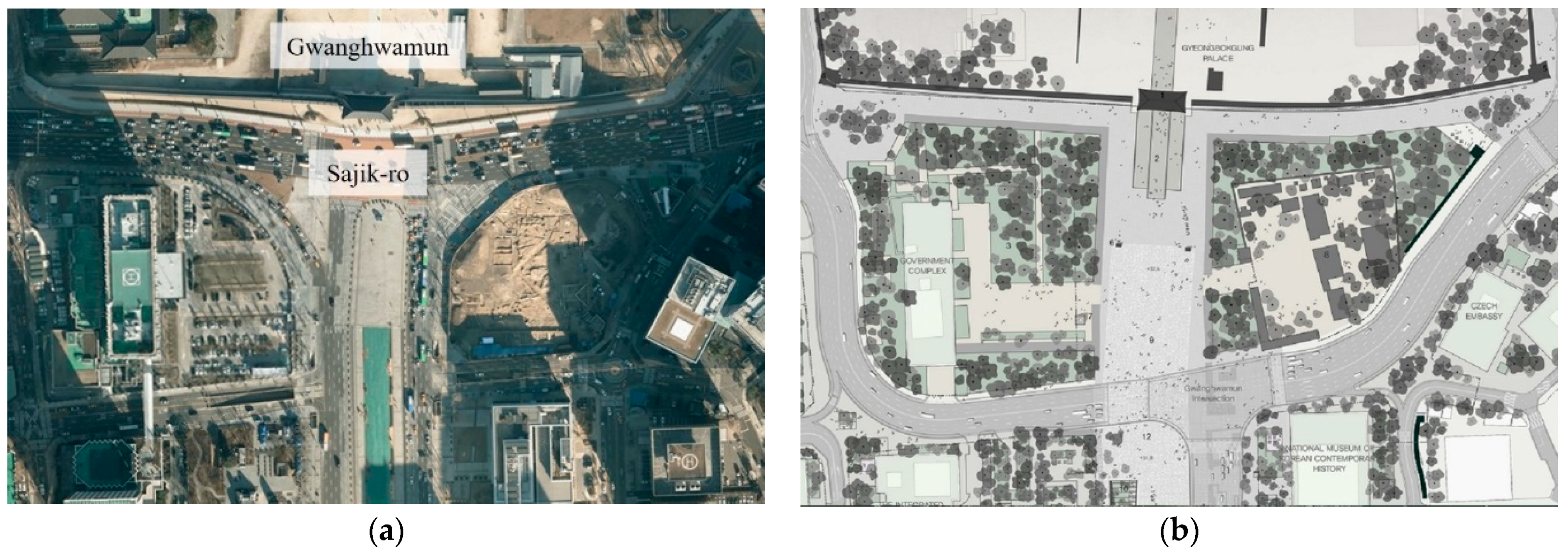
Gwanghwamun Square, which has a linear-shaped central plaza on the south side of Sajik-ro, was created in 2009 (Figure 8a). In 2018, a plan was announced to reorganize the central plaza to the eastern eccentricity, to reinforce pedestrianism, make use of historicity, and create a space for citizen-centered communications. The complete restoration of Wŏltae (which could not be restored in 2010) was visible at this time. The plan was to create a pedestrian space centered on history in front of Gwanghwamun, with Wŏltae at the center, and bypass Sajik-ro, the existing automobile road. This plan was first visualized during a joint presentation by the Cultural Heritage Administration and the Seoul Metropolitan Government (2018), and a design that faithfully reflected the government’s idea was selected as the winner of the competition (Figure 8b).
We attended and observed two public hearings hosted by the Seoul Metropolitan Government (Table 2). The public hearings were intended to nurture a progressive discourse by sharing the meaning and value of Gwanghwamun Square and Wŏltae with citizens. Experts made presentations that advised on the restructuring of Gwanghwamun Square that used historical data to explain its status and the need to restore the podium. After the expert presentation, a Q&A session was held between citizens and experts. Citizens’ questions were more like protests than queries regarding the contents of the presentation. For example, citizens expressed dissatisfaction with the restructuring of Gwanghwamun Square. They were outraged about the reconstruction’s inconvenient impact on traffic. They also bemoaned the fact that the construction was being paid for by their taxes. When it came to the Wŏltae restoration, citizens were less upset but still voiced some concerns. Citizens strongly opposed the detour required in the road by the creation of what they understood as an “unnecessary” podium. One citizen, who requested anonymity, asked fiercely why the architecture of an already-ruined dynasty needed to be restored today. Overall, we observed that citizens reacted very defensively when they felt they were being inconvenienced. Nora states that memory is a phenomenon that is always active in the present and a binding force experienced in the eternal present, but history is only a representation of the past [37] (p. 12). These public hearings clearly revealed the struggle between analytical history and collective memory. The current Gwanghwamun Square was built in 2009. No matter how much the purpose was to improve communication with pedestrians, the public had potential dissatisfaction with the restructuring work, which had only been 10 years, blocked the road again, and used taxes. The target, Wŏltae, was a good prey that could explode such anxiety of the public.
Meanwhile, after the 2000s, Hyoch’ang Park was further engaged in a way that strengthened the meaning of the patriots’ graves in the park [38,39]. After president Moon Jae-in’s remarks on the sanctification of Hyoch’ang Park in 2017, detailed discussions on its restructuring began under the title of “Hyochang Independence 100 Years Park.” In 2019, the Hyoch’ang Park area was selected as an urban regeneration activation area specializing in historical and cultural resources, and its restructuring emerged as a key issue of urban regeneration in the region. One of the most controversial issues in the recent Hyoch’ang Park restructuring discourse is the new location of Ŭiyŏlsa. The stakeholders of Seoul Metropolitan Government wanted to create an open space in the center of the park by moving the existing shrine further north (Figure 9). However, since Hyoch’ang Park was a nationally designated historic site, it was necessary to seek advice from experts in the field of cultural properties on the proper location of the shrine. Thus, the written interviews were conducted with experts between October and December 2020. Twenty Korean traditional architecture, history, modern architecture, and urban experts were consulted regarding the desirable location for Ŭiyŏlsa (Table 3). More than half of experts opposed the current plan to move the shrine to the north. According to the perspective of Neo-Confucianism, a grave is the place where the dead body resides, whereas a shrine is the place where the soul stays [40]. In the notion of Feng Shui, graves are built at the highest point, called Hyŏl, while shrines or other facilities are located in front of the grave, in the lower part [41]. Most of the heritage graves in Korea, including the royal tombs of the Chosŏn Dynasty, have such a spatial composition. Therefore, according to the traditional space configuration, the location of the shrines encompassing three grave areas in Hyoch’ang Park can be the existing position of Hyoch’ang Stadium. Of course, even experts know that it is realistically impossible to demolish Hyoch’ang Stadium and build a shrine. Therefore, a majority of the respondents answered that it is desirable to maintain the current location of the shrine. The reason why three experts answered that, if a new shrine is built, it should be located as far south as possible is because of the idea based on the traditional history of the heritage.
The results that raise problems in the plan were delivered to the Seoul Metropolitan Government, the organization in charge of the spatial restructuring of Hyoch’ang Park, as an advisory opinion. As expected, we observed that the city officials and stakeholders responsible for the restructuring of the park were uncomfortable with this advice because they were planning to move the shrine further north than its present location to enhance the leisure space in the park; more specifically, they sought to create an open space in the central zone of the park where Ŭiyŏlsa was originally located. They thought that the park’s restructuring should prioritize the enhancement of sports and leisure spaces for the public, such as Hyoch’ang Stadium and open spaces, over the spatial configuration of the park’s heritage features. Here we see a conflict between memory-based and history-based approaches to space.
In both cases, extensive historical research has been conducted to ensure the validity of restoration and relocation. Although this is valuable work based on theory, the approach still results in the physical and spatial expansion of the cultural heritage site. Heritage is metacultural [43] (pp. 179–183). In Urban’s model, metacultural production is specialized and requires experts to take responsibility for judging cultural objects [44]. Thus, although this work is an effort to restore the history of the heritage, it may be difficult for the public to be sympathetic with the project because it is being carried out under the judgment of experts. In front of Gwanghwamun, where the podium (1500 m2) should be placed, there is currently an automobile road over 40 m wide. Meanwhile, Hyoch’ang Stadium, the best place for the new shrine, is located at the southern end of the heritage park. When the park was designated as a historic site in 1989, the shrine was built in the form of a traditional ‘hanok’ (Figure 10). As shown in Figure 7b, it can be seen that the shrine was built at the southernmost point encompassing the tombs within the spatial constraints of the stadium. When the entire park is restructured, keeping the shape of the shrine and its enclosed courtyard intact (5000 m2) and moving it to the south according to the traditional spatial composition principle, does not mean coexistence with the stadium but forced occupation by spatial expansion of cultural heritage.
When citizens and stakeholders argue that Gwanghwamun Wŏltae should not be restored and that it is irrational to build a shrine in the Hyoch’ang Stadium, they express a discourse of collective memory from a modern and contemporary perspective. The essence of historical consciousness is nationalism, and the use of the word “memory” expresses a sense of resistance to “history,” an ideology that represents the interests of those in power [45] (pp. 15–17). For citizens, what is powerful is their memory based on their experience of the front of Gwanghwamun as a “road,” the symbol of convenience. They worry that the spatial expansion of the heritage site, like the restoration of Wŏltae, will seriously inconvenience them in terms of transportation. In the case of Hyoch’ang Park, it is absurd for government officers and stakeholders to propose a shrine at the site of the stadium because it weakens its leisure function for the public for whom Hyochang Park is primarily a “park” (Table 4).
3.4. A Bridge for Relieving Spatial Disagreement: VR and AR Restoration of Donŭimun
The physical conflict between an urban heritage and the surrounding structure is difficult to resolve because both sides presuppose their own valid logic. Experts claim restoration based on historical data, which is difficult for the public and stakeholders to understand. Here, Donŭimun’s digital restoration (2019) through VR and AR can suggest one possibility. The Rome Reborn Project [46,47,48] is one of the representative precedents for using VR and AR for cultural heritage. However, the case of Rome, where the city itself is a huge museum, is different from the case of Seoul, where cultural heritage is hidden in a rapidly developed urban structure. Donŭimun, like Wŏltae in Gwanghwamun or the royal tombs in Hyoch’ang Park, destroyed by the Japanese. Advanced technology is restoring the destroyed historical memory today.
Donŭimun was the western gate of the four gates of the Hanyang (now Seoul) City Wall. In September 1396 (Taejo 5), when the second construction of the wall and the eight gates were completed, it was built together and the name Donŭimun was given [21] (p. 124). Donŭimun maintained a long history, but disappeared in 1915 during the Japanese occupation because it was demolished as Japan developed Gyeongseong (now Seoul) and double-tracked the tramway (Figure 11a). Since then, a road has been in the place where the gate used to be. In 2009, the Seoul Metropolitan Government set a plan to restore Donŭimun—the only unrestored portion of the four gates of the Hanyang City Wall—to its original location by 2013 (Figure 11b).
Subsequently, budget and land compensation problems as well as prototyping controversies arose. Additionally, it proved difficult to resolve the burden of traffic congestion caused by closing the main roads in the city center for several years. Eventually, the restoration of Donŭimun was discontinued in 2014 due to practical problems. Finally, the Seoul Metropolitan Government decided to restore Donŭimun—forcibly demolished by the Japanese in 1915—in a symbolic rather than a physical manner by restoring it in the digital space in August 2019, 104 years after its demolition. It was revealed in a way that was easily accessible to the public. If people visit Jeongdong Intersection where Donŭimun used to be, there is now Donŭimun Museum Village, which has a VR experience hall, where they can enjoy digitally restored panoramic views of Donŭimun and Hanyang during the Josŏn era, using head-mounted displays (Figure 12a). In addition, by installing the “Donŭimun augmented reality” application on their mobile phones, visitors can take pictures of the Jeongdong Intersection where Donŭimun used to be and view AR images of Donŭimun restored on their mobile phone screen by pointing it toward the road (Figure 12b).
The digital restoration of Donŭimun can be considered primarily in terms of placeness and spatiality. In other words, the physical placeness, which is difficult to recover in reality, has been restored in the form of an abstract spatiality called the Cartesian Grid. In Germany, during the 19th century, space was a very physical concept, but with the emergence of discourses about space in a modern sense, three-dimensional solids began to be recognized as a core attribute of architecture (Gottfried Semper (1803–1879) used “Primitive Hut” as an example in “The Four Elements of Architecture” (1851), and space was regarded as one of the fundamental elements of architecture. When explained in terms of attributes, space is a physical concept, as in the case of a room (Raum), rather than an abstract virtual concept [51]). However, after that, the concept of space went through a process of solidifying abstraction, led by art historians in the 1920s (Herman Sörgel (1885–1952) is a representative of historians in the 1920s, and his book “Architecktur Ästhetik” (1921) clearly summarized theories from Vitruvian to Kant through the contemporary era. It was space that was presented as a frame to organize the concept of architecture. At that time, space began to be represented using lines, as a concept of architecture that secured abstraction and could no longer be misunderstood [52] (p. 161)). Additionally, the abstraction of space gained general consent from the architectural world through the study and practice of a contemporary architectural organization called “Bauhaus.” The word space appeared in the title of the 20th century’s architectural history bible, “Space, Time and Architecture” (1941) by Siegfried Giedion (1888–1968) and became an ideological slogan of architecture [52] (p. 163). However, as the 1950s progressed, the abstractness of space and its characteristics of homogeneity and infinite expandability became subjects of criticism, and were cited as the main culprits for homogenizing the entire world while ignoring the placeness of each region. Additionally, Martin Heidegger’s (1889–1976) existentialist and phenomenological philosophy spurred a new breakthrough in modern architecture by offering a framework by which the theory of place could be criticized as an abstract spatiality. This theory of place was very attractive to the architectural world at that time and, in particular, the writings of critics such as Christian Norberg-Schulz (1926–2000) and Kenneth Frampton (1930–present) became the basis for asserting both “soul of place” and critical regionalism. Therefore, Donŭimun’s digital restoration is a phenomenon in which placeness returns to spatiality. The concept of placeness emerged as an anti-thesis to the abstraction of space. However, when it is difficult to express placeness due to a practical problem, it continues to rely on the abstraction of space. A significant feature of digital space is that there are no physical restrictions, and it is completely free of the various problems that could arise when it is built on actual ground, such as enormous construction costs and land occupancy. The expense of actual restoration of Donŭimun was estimated to cost $84 million, while development in VR and AR cost $420,000, or 0.5% of this.
Further, Donŭimun’s restoration through VR and AR makes it possible to transform the public’s collective memory, which remained in the framework of the existing urban structure, into a cultural memory. The collective memory characterizes individuals’ memories, which are uncertain and fragmented, and these memories acquire a socially shared meaning through mutual communication within the framework of society (The study of memory was first attempted by Maurice Halbwachs (1877–1945), a French sociologist. In La Mémoire collective, first published in 1941, he invented the concept of collective memory, which was an answer to the question, “What binds the society?”). Even past historical events are remembered based on the present, and, in this process, the past is not preserved as it is but reconstructed from the present viewpoint [53] (p. 172). It can, therefore, be said that Sajik-ro rather than Gwanghwamun and Wŏltae, Hyoch’ang Stadium rather than the shrine, and Jeongdong Intersection rather than Donŭimun, are powerful collective memories that exist among the public. In contrast, cultural memory refers to memories that are systematically consolidated and methodically transmitted [45] (p. 51). Cultural memory is a process in which memories do not exist in the form of individual dimensions or abstract meanings, but are stored and transmitted by various cultural representations and, thus, acquire social and cultural meanings [54] (p. 42). The core of cultural memory is practice, which implies that even if certain memories exist within a group, they can function as a specific perception in society only when they pass through the process of preservation and transmission, as they become materialized through embodied symbols (Cultural memory—a memory that acquires meaning by being stored and transmitted by various actual representations—was first proposed in the 1980s by a German couple: Jan Assmann (1938–present), an archaeologist, and his wife Aleida Assmann (1947–present), a professor in English and Literary Studies [55]). Although cultural memory engages records, texts, buildings, and festivals as media, it is important to note that its current status is expanding due to the audiovisual intensity of new electronic media and the emotional power of art. From this point of view, sharing Donŭimun with the public through digital restoration is meaningful in that it presents a methodology for creating a new cultural memory that does not physically damage the collective memory of the public. For example, as of May 2019, an average of 2000 people visited the experience center per day and more than 92% of the visitors were satisfied with the exhibition and experience [56] (p. 193). In other words, if there is a disagreement in the actual restoration of cultural heritage in the city, providing it in virtual and augmented reality first can be an effective visual platform for communication between stakeholders. Rather than hastily restructuring the podium in Gwanghwamun and the shrine in Hyoch’ang Park, going through the buffering steps can be one way to alleviate the conflict of opinion.
In the case of Gwanghwamun, the creation of a new plaza in front of the gate is to strengthen the pedestrian and communication of the public. As of 2021, the historic plaza is under construction and Wŏltae is also being restored. However, as mentioned earlier, the entire restructuring project of Gwanghwamun Square was under attack because of the historic podium. In this situation, the new plaza is created first and Wŏltae can be displayed in VR, AR, or with holograms on it. This transition process can create a new discourse on whether or not to restore it in actuality. In the case of Hyoch’ang Park, only issues related to the patriots and the location of the shrine are emphasized, and there is a neglect of the fundamental spatiality of Hyoch’ang ‘Won’, the royal mausoleum. If Hyoch’ang Stadium is remodeled in the future, a VR experience hall will be created in some space of the stadium. There, people will be able to visually experience the buried history of the place as the tomb of royalty. Like Donŭimun, where the current tombs of patriots are photographed with a mobile phone, it will be possible to display the tombs and sculptures of the royal family in the Josŏn Dynasty in AR. When the severed narrative of the place is activated through the advanced technology, people will come to realize that the debate over the location of the shrine has been an unessential and exhausting one. This is how the new technology connects the forgotten history with the present memory.
4. Conclusions
Both Gwanghwamun and Hyoch’ang Park started their place identity during the Chosŏn dynasty. However, during the Japanese colonial period, they suffered severe deterioration in their placeness and rapid changes in their surrounding urban structure. National attempts were made to regain their destroyed placeness in the modern period (1945–2000s). By the 2010s, spatial restructuring was underway in Gwanghwamun and Hyoch’ang Park. Experts with historical data and theoretical frameworks insisted on restoring the podium of the palace and relocating the shrine of the park. The problem is that this involves the spatial expansion of the cultural heritage site, and this initiative has not gained public support—we found that the public and stakeholders were worried about the removal of the roads and the weakening of the function of the park. For them, the facilities that exist in their memories are far more important than the history of the sites. Physical restoration of cultural properties within the city is difficult to realize due to practical problems.
We argue that Donŭimun’s digital restoration and public sharing through VR and AR can be a desirable case mediating the disagreement. The fusion of cultural heritage and advanced technology involves restoring placeness in a virtual space and is an economically practical method. Digital restorations that can be shared with the public are meaningful; they offer a way to create a new cultural memory without physically damaging the urban structure containing the public’s collective memory. Of course, the digital restoration of cultural properties is only one possible bridge to solve such spatial conflict. Nonetheless, it is important to digitize the actual restoration plan through advanced technology and share it with the public. This is because it forms a visual platform for discourse on whether to proceed with actual restoration.
Of course, virtual heritage cannot enrich our real-life environment. It will be most important to find a physical agreement where cultural heritage and urban structure coexist wisely. Meanwhile, the integration of cultural heritage and cutting-edge technology dealt with in this study is still in the experimental stage. It is difficult to say yet that VR or AR is producing tangible cultural memory. However, in the field and academia, MR (Mixed Reality), XR (Extended Reality), and SR (Substitutional Reality) are rapidly developing and being actively discussed. It remains to be seen what digital heritage will be created in the future.
Author Contributions
Conceptualization, H.-C.Y. and S.-L.R.; methodology, H.-C.Y.; validation, H.-C.Y. and S.-L.R.; formal analysis, H.-C.Y. and S.-L.R.; investigation, H.-C.Y. and S.-L.R.; resources, H.-C.Y. and S.-L.R.; data curation, H.-C.Y. and S.-L.R.; original draft preparation, H.-C.Y. and S.-L.R.; review and editing, S.-L.R.; visualization, H.-C.Y. All authors have read and agreed to the published version of the manuscript.
Funding
This research received no external funding.
Conflicts of Interest
The authors declare no conflict of interest.
References
- Uriely, N.; Israeli, A.A.; Reichel, A. Heritage proximity and resident attitudes toward tourism development. Ann. Tour. Res. 2002, 29, 859–861. [Google Scholar] [CrossRef]
- Bloch, N. Evicting heritage: Spatial cleansing and cultural legacy at the Hampi UNESCO site in India. Crit. Asian Stud. 2016, 48, 556–578. [Google Scholar] [CrossRef]
- Bertram, H. Discourses and Practices of Dealing with the Spatial Legacy of Conflict in Belfast: The Cases of Crumlin Road Gaol and Girdwood Park. In Heritage after Conflict; Crooke, E., Maguire, T., Eds.; Routledge: Abingdon-on-Thames, UK, 2018; pp. 103–117. [Google Scholar]
- Gillespie, J. Buffering for conservation at Angkor: Questioning the spatial regulation of a World Heritage property. Int. J. Herit. Stud. 2012, 18, 194–208. [Google Scholar] [CrossRef]
- Janssen, J.; Luiten, E.; Renes, H.; Rouwendal, J. Heritage planning and spatial development in the Netherlands: Changing policies and perspectives. Int. J. Herit. Stud. 2014, 20, 1–21. [Google Scholar] [CrossRef] [Green Version]
- Rzasa, K.; Ogryzek, M.; Kulawiak, M. Cultural Heritage in Spatial Planning. In Proceedings of the 2016 Baltic Geodetic Congress (BGC Geomatics), Gdansk, Poland, 2–4 June 2016; Institute of Electrical and Electronics Engineers: Piscataway, NJ, USA, 2016; pp. 85–89. [Google Scholar]
- Park, M.S. Typification and application of local history and culture resources: Focused on the case of Hwasun Gun. J. Reg. Cult. 2018, 5, 87–112. [Google Scholar] [CrossRef]
- Oh, S.K.; Cho, H.S.; Kim, C.D. Analysis on conservation methods of the historical and cultural environment in Kongju City, Korea. J. Korea Plan. Assoc. 2001, 36, 225–239. [Google Scholar]
- Lee, H.Y.; Hwang, K.H. A case study on the housing complex considered with historic cultural resources in Korea—Focused on the implication from development process and housing space. J. Urban Des. Inst. Korea 2009, 10, 5–24. [Google Scholar]
- Choi, K.R.; Lee, S.H. A case study on urban regeneration through historical environment: Incheon Art Platform Project in the old downtown of the city of Incheon. J. Korea. Plan. Assoc. 2008, 44, 219–230. [Google Scholar]
- Lee, H.R.; Lee, S.J. A study on the preservation and application of the architectural culture resource in Na-Ju Eupseong Space. J. Urban Des. Inst. Korea 2012, 13, 61–72. [Google Scholar]
- Park, C.H. A Street regeneration plan for small and medium-sized cities, utilizing historic and cultural heritage—Focusing on the modern building of Chung-Ang Street in Ganggyeong, Nonsan. J. Urban Des. Inst. Korea 2013, 14, 49–66. [Google Scholar]
- Park, J.P. A study on the historic and cultural resources for landscape planning—A Case of Cheongju City. J. Korean Inst. Rural Archit. 2015, 17, 55–64. [Google Scholar]
- Park, S.M.; Lee, J.H. A study on the planning characteristics of street improvement projects using historical and cultural resources—Focusing on the prize winners of the Korea Landscape Awards. J. Resid. Environ. Inst. Korea 2015, 13, 79–93. [Google Scholar]
- Choi, D.A.; Kim, M. Revitalization of local tourism utilizing historical culture resources—Focused on Songpa-gu Hansung Baekje historical culture resources. Cult. Converg. 2017, 39, 61–92. [Google Scholar]
- Cabrera, I.; Fenollosa, E.; Serrano, B. The new entrance to the Camí d’Onda Air-raid Shelter in the historic center of Borriana, Spain. Techne 2020, 19, 290–297. [Google Scholar]
- Shin, H.D.; Zoh, K.J. A study of the planning process, design idea and implementation of the Gwanghwamun plaza. J. Korean Inst. Landsc. Archit. 2013, 41, 24–41. [Google Scholar] [CrossRef]
- Kang, N.H.; Song, I.H. A study on a reconstruction of Gwanghwamun and fluctuation of boulevard in front of Gwanghwamun. J. Archit. Hist. 2015, 24, 7–18. [Google Scholar] [CrossRef]
- Kim, H.K. Formation of spatiality and interpretation of changes in Hyochang Park. Seoul Stud. 2010, 39, 79–117. [Google Scholar]
- Han, S.Y.; Kim, Y.G.; Zoh, K.J. The process of place reproduction in Hyochang Park and the social reconstruction of place identity. J. Korean Inst. Tradit. Landsc. Archit. 2011, 9, 165–177. [Google Scholar]
- Nah, K. Value of Seoul Castle and Donuimun (Gate of Honoring Righteousness). Seoul Hist. 2011, 77, 117–144. [Google Scholar]
- Seoul Metropolitan Government. Hyochang Park Memorial Project. Available online: https://www.hyochangpark.com (accessed on 14 August 2021).
- Ryoo, S.L. Authenticity of Gwanghwamun. In Gwanghwamun Square, Look Again, Make Again; Kyŏnginmunhwasa: Seoul, Korea, 2020; pp. 164–185. [Google Scholar]
- Cultural Heritage Administration. Gyeongbokgung Gwanghwamun Woldae and East-West Cross-Gak Area Report Research Service Report; Cultural Heritage Administration: Taejŏn, Korea, 2018.
- National Archives of Korea. Gwanghwamun after Relocation (Control Number: CET0074941). Available online: http://theme.archives.go.kr/viewer/common/archWebViewer.do?bsid=200200080545&dsid=000000000013&gubun=search (accessed on 14 August 2021).
- Seoul Metropolitan Government. Seoul Symbol Street Creation Plan; Seoul City Landscape Division: Seoul, Korea, 1994.
- Seoul Metropolitan Government. Basic Plan for a Demonstration View Street; Seoul Metropolitan Government: Seoul, Korea, 1999.
- Cultural Heritage Administration. Establishment of the Basic Direction for the Construction of Gwanghwamun Historic Plaza; Cultural Heritage Administration: Taejŏn, Korea, 2005.
- Seoul Metropolitan Government. Comprehensive Plan for Urban Recreation; Seoul Metropolitan Government: Seoul, Korea, 2007.
- National Archives of Korea. View of Gwanghwamun 1 (Control Number: CET0047541). Available online: http://theme.archives.go.kr/viewer/common/archWebViewer.do?bsid=200200061851&dsid=000000000001&gubun=search (accessed on 14 August 2021).
- Seoul Museum of History. Concrete Gwanghwamun, Meet at the Seoul Museum of History. Available online: https://museum.seoul.go.kr/www/board/NR_boardView.do?bbsCd=1014&seq=00000000000001360&sso=ok (accessed on 14 August 2021).
- Seoul History Archive. Josŏn (Archive Number: 82099). Available online: https://museum.seoul.go.kr/archive/archiveView.do?type=D&arcvGroupNo=2901&arcvMetaSeq=30897&arcvNo=82099 (accessed on 14 August 2021).
- Cultural Heritage Administration. Josŏn Royal Tomb. Available online: https://royaltombs.cha.go.kr/tombs/selectTombInfoList.do?tombseq=155&mn=RT_01_11_02 (accessed on 14 August 2021).
- Korean Association for Architectural History. Survey for the History of Hyoch’ang Park and Changes in Urban Space; Koryomunwhasa: Seoul, Korea, 2021.
- Seoul Metropolitan Government. Hyoch’ang Park Maintenance and Shrine Construction Master Plan Report; Seoul Metropolitan Government: Seoul, Korea, 1985.
- Seoul Metropolitan Government. Project Seoul. Available online: https://project.seoul.go.kr/view/viewDetailArch.do?cpttMstSeq=229&pageIndex=1¶mMap%5B%27prev%27%5D=cpttMstSeq%253D229%2526pageIndex%253D1 (accessed on 14 August 2021).
- Nora, P. Zwischen Geschichte und Gedächtnis; Kaier, W., Translator; Fischer Taschenbuch: Frankfurt, Germany, 1998. [Google Scholar]
- Yongsan’gu. Basic and Detailed Design Service for Reorganization of Hyoch’ang Neighborhood Park; Yongsan’gu: Seoul, Korea, 2001.
- Ministry of Patriots and Veterans Affairs. Hyoch’ang Independent Park Project Preliminary Plan; Ministry of Patriots and Veterans Affairs: Sejong, Korea, 2005.
- Korea Creative Contents Agency: Jongmyo System. Available online: https://www.culturecontent.com/content/contentView.do?content_id=cp032204440001 (accessed on 5 August 2021).
- Cultural Heritage Administration. Palace Ruins Headquarters Joseon Royal Tombs. Available online: http://royaltombs.cha.go.kr (accessed on 5 August 2021).
- Seoul Metropolitan Government. 2020 Hyoch’ang Independence 100 Years Park Creation Public Discussion and Basic Plan Service Summary Report; Seoul Metropolitan Government: Seoul, Korea, 2020; ISBN 51-6110000-002437-01.
- Kirshenblatt-Gimblett, B. World Heritage and Cultural Economics. In Museum Frictions: Public Cultures/Global Transformations; Karp, I., Kratz, C.A., Szwaja, L., Eds.; Duke University Press: Durham, NC, USA, 2006; pp. 161–202. [Google Scholar]
- Urban, G. Metaculture: How Cultures Move through the World; University of Minnesota Press: Minneapolis, MN, USA, 2001. [Google Scholar]
- Chun, J.S. History Tells Memories; Humanist Publishing Group: Seoul, Korea, 2009. [Google Scholar]
- Guidi, G.; Frischer, B.; Lucenti, I. Rome Reborn—Virtualizing the Ancient Imperial Rome. In Workshop on 3D Virtual Reconstruction and Visualization of Complex Architectures; Fondazione Bruno Kessler: Trento, Italy, 2007. [Google Scholar]
- Dylla, K.; Frischer, B.; Müller, P.; Ulmer, A.; Haegler, S. Rome reborn 2.0: A case study of virtual city reconstruction using procedural modeling techniques. Comput. Graph. World 2008, 16, 62–66. [Google Scholar]
- Frischer, B.; Abernathy, D.; Guidi, G.; Myers, J.; Thibodeau, C.; Salvemini, A.; Minor, B. Rome Reborn. In Proceedings of the SIGGRAPH 08: Special Interest Group on Computer Graphics and Interactive Techniques Conference (ACM SIGGRAPH 2008 New Tech Demos), Los Angeles, CA, USA, 11–15 August 2008; Association for Computing Machinery: New York, NY, USA, 2008. [Google Scholar]
- Seoul History Archive. Donŭimun (Archive Number: 8635). Available online: https://museum.seoul.go.kr/archive/archiveView.do?currentPage=55&type=A&type2=year&arcvGroupNo=345&lowe-ArcvGroupNo=&arcvMetaSeq=7685&arcvNo=8635&realArcvGroupNo=2943&searchVal= (accessed on 14 August 2021).
- Seoul Metropolitan Government. Donŭimun Restoration Feasibility Study and Basic Plan; Seoul Metropolitan Government: Seoul, Korea, 2010.
- Semper, G. The Four Elements of Architecture and Other Writings; Mallgrave, H.F.; Herrmann, W., Translators; Cambridge University Press: Cambridge, UK, 1989. [Google Scholar]
- Seo, H. A study on the formation of abstract concept of ‘space’ in architecture. J. Archit. Inst. Korea Plan. Des. 2009, 25, 157–164. [Google Scholar]
- Halbwachs, M. La Topographie Légendaire des Évangiles en Terre Sainte: Étude de Mémoire Collective, Les Cadres Soiaux de la Mémoire [On Collective Memory]; Coser, L.A., Translator; University of Chicago Press: Chicago, IL, USA, 1992. [Google Scholar]
- Tae, J.H. Memory Culture Research; Communication: Seoul, Korea, 2014. [Google Scholar]
- Assmann, A. Erinnerungsraume: Formen und Wandlungen des Kulturellen Gedachtnisses [Memory spaces: Forms and changes in cultural memory]; Byeon, H.S.; Chae, Y.S., Translators; Greenbe: Seoul, Korea, 2011. [Google Scholar]
- Jeong, S.J.; Lee, T.H. A Study on the Present Condition and Prospect of Architectural Cultural Heritage Content Applied to 3D Digital Technology. J. Korea Acad. Ind. Coop. Soc. 2021, 22, 188–198. [Google Scholar]
Figure 1.
The cases: (a) Location of research subjects in Seoul; (b) Gwanghwamun Square; (c) Hyoch’ang Park. Reprinted with permission from Ref. [22]. Copyright 2021 Seoul Metropolitan Government; (d) A road built on the site of Donŭimun and Donŭimun Museum Village.
Figure 1.
The cases: (a) Location of research subjects in Seoul; (b) Gwanghwamun Square; (c) Hyoch’ang Park. Reprinted with permission from Ref. [22]. Copyright 2021 Seoul Metropolitan Government; (d) A road built on the site of Donŭimun and Donŭimun Museum Village.

Figure 2.
Research method.

Figure 3.
(a) Gwanghwamun and Wŏltae, estimated 1890s. Reprinted with permission from Ref. [24] (p. xv). Copyright 2018 Cultural Heritage Administration; (b) Gwanghwamun relocated without Wŏltae, estimated 1927. Reprinted with permission from Ref. [25]. Copyright 2021 National Archives of Korea.

Figure 4.
(a) Gwanghwamun rebuilt with reinforced concrete, 1968. Reprinted with permission from Ref. [30]. Copyright 2021 National Archives of Korea; (b) Concrete column capital detail, 2008. Reprinted with permission from Ref. [31]. Copyright 2008 Seoul Museum of History.

Figure 5.
Changes in the temporal position of Gwanghwamun and Wŏltae.

Figure 6.
(a) Grave of Ŭibinsŏngssi seen behind the Hyoch’ang Golf Course, early 1920s. Reprinted with permission from Ref. [32]. Copyright 2021 Seoul History Archive; (b) Grave of Munhyoseja, relocated to the outside of Seoul, 2018. Reprinted with permission from Ref. [33]. Copyright 2021 Cultural Heritage Administration.

Figure 7.
(a) Hyoch’ang Stadium built toward Kim gu’s grave area, 1965. Reprinted with permission from Ref. [22]. Copyright 2021 Seoul Metropolitan Government; (b) Ŭiyŏlsa built in the center of the park, location A, 1985 (Title translation in the upper left: The shrine’s planned site). Reprinted with permission from Ref. [35] (p. 14). Copyright 1985 Seoul Metropolitan Government.

Figure 8.
(a) Current Gwanghwamun; (b) Site plan of Gwanghwamun Square restructuring competition winner, 2019. Reprinted with permission from Ref. [36]. Copyright 2019 Seoul Metropolitan Government.
Figure 8.
(a) Current Gwanghwamun; (b) Site plan of Gwanghwamun Square restructuring competition winner, 2019. Reprinted with permission from Ref. [36]. Copyright 2019 Seoul Metropolitan Government.

Figure 9.
(a) Hyoch’ang Park’s present; (b) Hyoch’ang Park restructuring plan in 2020. Reprinted with permission from Ref. [42] (p. 133). Copyright 2020 Seoul Metropolitan Government.
Figure 9.
(a) Hyoch’ang Park’s present; (b) Hyoch’ang Park restructuring plan in 2020. Reprinted with permission from Ref. [42] (p. 133). Copyright 2020 Seoul Metropolitan Government.

Figure 10.
The shrine, Ŭiyŏlsa. Reprinted with permission from Ref. [34] (p. 152). Copyright 2021 Seoul Metropolitan Government.
Figure 10.
The shrine, Ŭiyŏlsa. Reprinted with permission from Ref. [34] (p. 152). Copyright 2021 Seoul Metropolitan Government.

Figure 11.
(a) Donŭimun before destruction, estimated early 1900s. Reprinted with permission from Ref. [49]. Copyright 2021 Seoul History Archive; (b) Donŭimun restoration plan in physical place, 2010. Reprinted with permission from Ref. [50] (p. 5). Copyright 2010 Seoul Metropolitan Government.

Figure 12.
Field survey: (a) A virtual reality experience hall that visualizes the gate and the city view during the Josŏn era; (b) Augmented reality for the location and shape of Donŭimun that can be checked through a mobile phone.
Figure 12.
Field survey: (a) A virtual reality experience hall that visualizes the gate and the city view during the Josŏn era; (b) Augmented reality for the location and shape of Donŭimun that can be checked through a mobile phone.


Table 1.
Historical transformation of heritage.
| Century | Gwanghwamun | Hyoch’ang Park | ||
|---|---|---|---|---|
| Gate and Roof | Podium | Graves | Shrine | |
| 14C | 1398, First built | Not in existence | - | - |
| 15C | - | 1430s, Construction discussed | - | - |
| 16C | 1592, Demolished | - | - | |
| 17C | - | - | - | |
| 18C | - | 1786, First built (royal family) | ||
| 19C | 1860s, Rebuilt | - | - | |
| 20C | 1927, Relocated | 1927, Demolished | 1944, Relocated 1946–1948, Newly built (patriots) | 1944, Demolished |
| 1968, Rebuilt to original location (Reinforced concrete) | 1968, Not restored | - | 1989, First built (patriots) | |
| 21C (Before 2011) | 2010, Rebuilt to same location (Traditional material) | 2010, Not restored | - | - |
Table 2.
Outline of the public hearings.
| Item | Public Hearing 1 | Public Hearing 2 |
|---|---|---|
| Subject | The status of Gwanghwamun Square and the development direction of the surrounding area | The historical status of Gwanghwamun Square and Wŏltae |
| Date | 15:00–17:50, 15 November 2019 | 15:00–18:00, 21 November 2019 |
| Location | 82, Saemunan-ro, Jongno-gu, Seoul | 70, Sogong-ro, Jung-gu, Seoul |
| Attendees | 150 people (10 experts and citizens) | Not counted (11 experts and citizens) |
| Program | Expert presentation → Citizen Q&A | |
Table 3.
Results of expert interviews on the location of Ŭiyŏlsa.
| Question | Answer | Number of Replies |
|---|---|---|
| 1. Is the current position of Ŭiyŏlsa suitable? | Suitable | 12 |
| Not suitable | 5 | |
| No answer | 3 | |
| Sum | 20 | |
| 2. Is it suitable to relocate Ŭiyŏlsa to the north of its present location? | Suitable | 5 |
| Not suitable | 11 | |
| No answer | 4 | |
| Sum | 20 | |
| 3. Where would be a suitable place for Ŭiyŏlsa? (Excluding the positions of Q 1 and 2). | Ŭiyŏlsa should be moved as far south as possible from its current location. | 3 |
| The location of the tomb should be changed, not the cemetery. | 1 | |
| No answer | 16 | |
| Sum | 20 |
The 20 experts all majored in history or traditional architecture, and consisted of 14 professors, 5 architects, and 1 government officer. The table was edited based on the contents of the survey book [34] (p. 267) as expert interviews conducted by the author.
Table 4.
Interpretation of the conflict situations.
| Groups/Cases | Gwanghwamun | Hyoch’ang Park | |
|---|---|---|---|
| Experts | Issue | Restoration of the podium toward the road | Relocation of the shrine to the south |
| Evidence | Analytical history | ||
| Result | Spatial expansion of heritage | ||
| Citizens/ stakeholders | Issue | Maintenance of the road | Maintenance of the stadium |
| Evidence | Collective memory | ||
| Result | Spatial conflict with heritage | ||
Publisher’s Note: MDPI stays neutral with regard to jurisdictional claims in published maps and institutional affiliations. |
© 2021 by the authors. Licensee MDPI, Basel, Switzerland. This article is an open access article distributed under the terms and conditions of the Creative Commons Attribution (CC BY) license (https://creativecommons.org/licenses/by/4.0/).
Share and Cite
MDPI and ACS Style
Youn, H.-C.; Ryoo, S.-L. VR and AR Restoration of Urban Heritage: A Virtual Platform Mediating Disagreement from Spatial Conflicts in Korea. Buildings 2021, 11, 561. https://0-doi-org.brum.beds.ac.uk/10.3390/buildings11110561
AMA Style
Youn H-C, Ryoo S-L. VR and AR Restoration of Urban Heritage: A Virtual Platform Mediating Disagreement from Spatial Conflicts in Korea. Buildings. 2021; 11(11):561. https://0-doi-org.brum.beds.ac.uk/10.3390/buildings11110561
Chicago/Turabian StyleYoun, Hyun-Chul, and Seong-Lyong Ryoo. 2021. "VR and AR Restoration of Urban Heritage: A Virtual Platform Mediating Disagreement from Spatial Conflicts in Korea" Buildings 11, no. 11: 561. https://0-doi-org.brum.beds.ac.uk/10.3390/buildings11110561
Note that from the first issue of 2016, this journal uses article numbers instead of page numbers. See further details here.