Article

Architectural Survey, Diagnostic, and Constructive Analysis Strategies for Monumental Preservation of Cultural Heritage and Sustainable Management of Tourism

by
Adela Rueda Márquez de la Plata
1,
Pablo Alejandro Cruz Franco
2 and
Jorge Alberto Ramos Sánchez
1,*
1
Department of Graphic Expression in Architecture, University of Extremadura, 10003 Caceres, Spain
2
Department of Construction, University of Extremadura, 10003 Caceres, Spain
*
Author to whom correspondence should be addressed.
Submission received: 15 May 2022 / Revised: 14 July 2022 / Accepted: 28 July 2022 / Published: 3 August 2022
(This article belongs to the Special Issue Advanced Technologies in Architectural Heritage Protection)

Abstract

:
Heritage is under constant pressure to be adapted for tourism. The aim of this research was to improve the performance of both the tourism sector and the cultural heritage sector in a balanced and sustainable way, by considering the principles of conservation and preservation. Non-invasive tools such as ground penetrating radar (GPR), unmanned aerial vehicle (UAV), and even virtual reality (VR) and augmented reality (AR) technologies have been used to develop new methodologies, allowing us to generate new experiences and heritage tourist attractions, which not only do not generate negative impacts on the monuments themselves, but also promote their preservation without diminishing the cultural and tourist offers of the city. A case study was carried out on Mérida, a UNESCO World Heritage City, where tourism is a strong economic engine of the city. The results obtained are two-fold: on one hand, an effective interdisciplinary working methodology for heritage management was developed, and on the other hand, new approaches for the sustainable development of cultural tourism were generated.

1. Introduction

1.1. Definition of the Conceptual Framework of the Research

This research and its results and conclusions are part of an overall research project, with a total duration of three years (2021–2023), which is still ongoing. This comprehensive project, and its first reliable results presented here, has been and is funded by the Consejería de Economía, Ciencia y Agenda Digital de la Junta de Extremadura and the European Regional Development Fund of the European Union.
The project, called “Application of VR technologies and 6D surveys for the implementation of universal accessibility in the archaeological heritage of Roman public buildings”, is framed within the priorities outlined in the 6th Regional I + D + i Plan (2017–2020) of Extremadura, fulfilling some of the general objectives of the Plan.
First, it promotes scientific-technological leadership as well as the internationalisation of the I+D of the collaborating institutions and their researchers (University of Extremadura and the Consorcio Ciudad Monumental de Mérida). There are currently no 6D GIS-BIM archaeological settlements developed for VR access. For the development of the global research project, general objectives were established that articulate and structure the activities and tasks proposed for the three years. These objectives are:
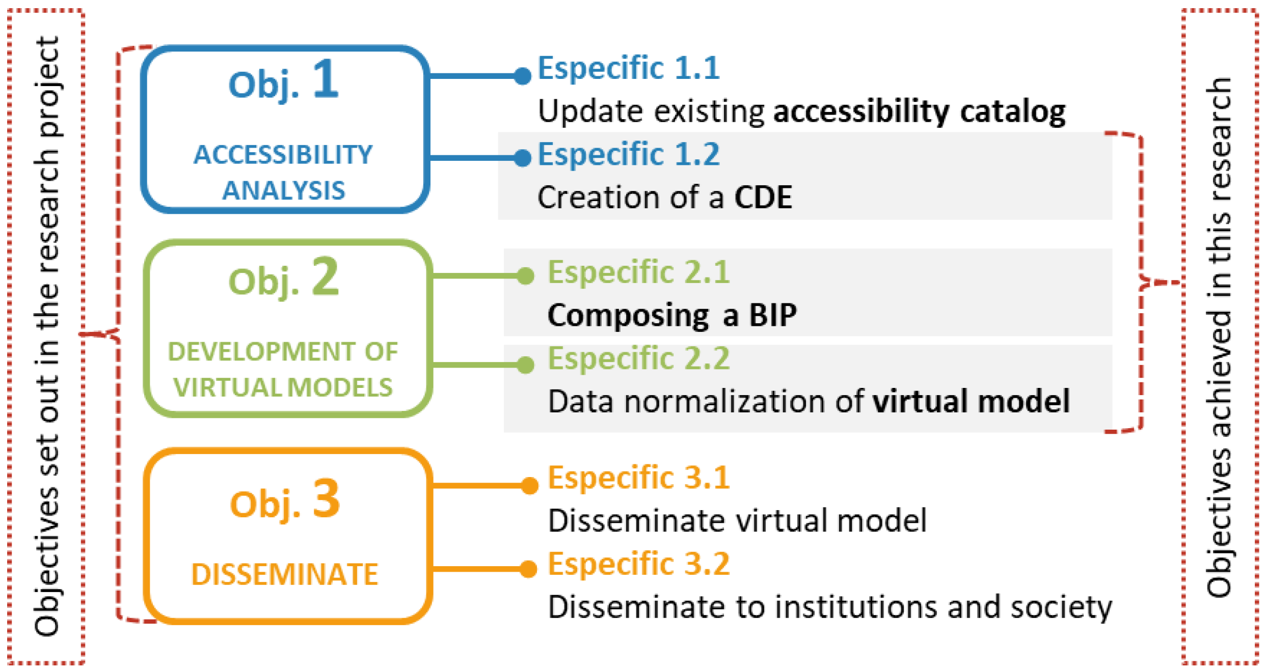
  • To draw up a gradient of accessibility in the Archaeological Heritage of Public Buildings from the Roman period within the city of Mérida including, for the first time, all of the buildings, buried buildings, areas closed to the public, and those in danger of ruin or destruction.
  • Elaborate a methodology for the creation and development of virtual 6D models of the most vulnerable architectural heritage due to its high tourist impact for its virtual reconstruction.
  • Transmit to society, the scientific community, and institutions that the virtualisation of heritage is necessary for the comprehension of a more efficient and sustainable tourism.
This article presents the tasks undertaken and the tested results, which serve as a basis for the following phases of the research, responding to specific objectives 1.2 and 2.1 and the creation of protocols that will serve as a basis for the achievement of objective 2.2 of the overall research project (Figure 1):
1.2
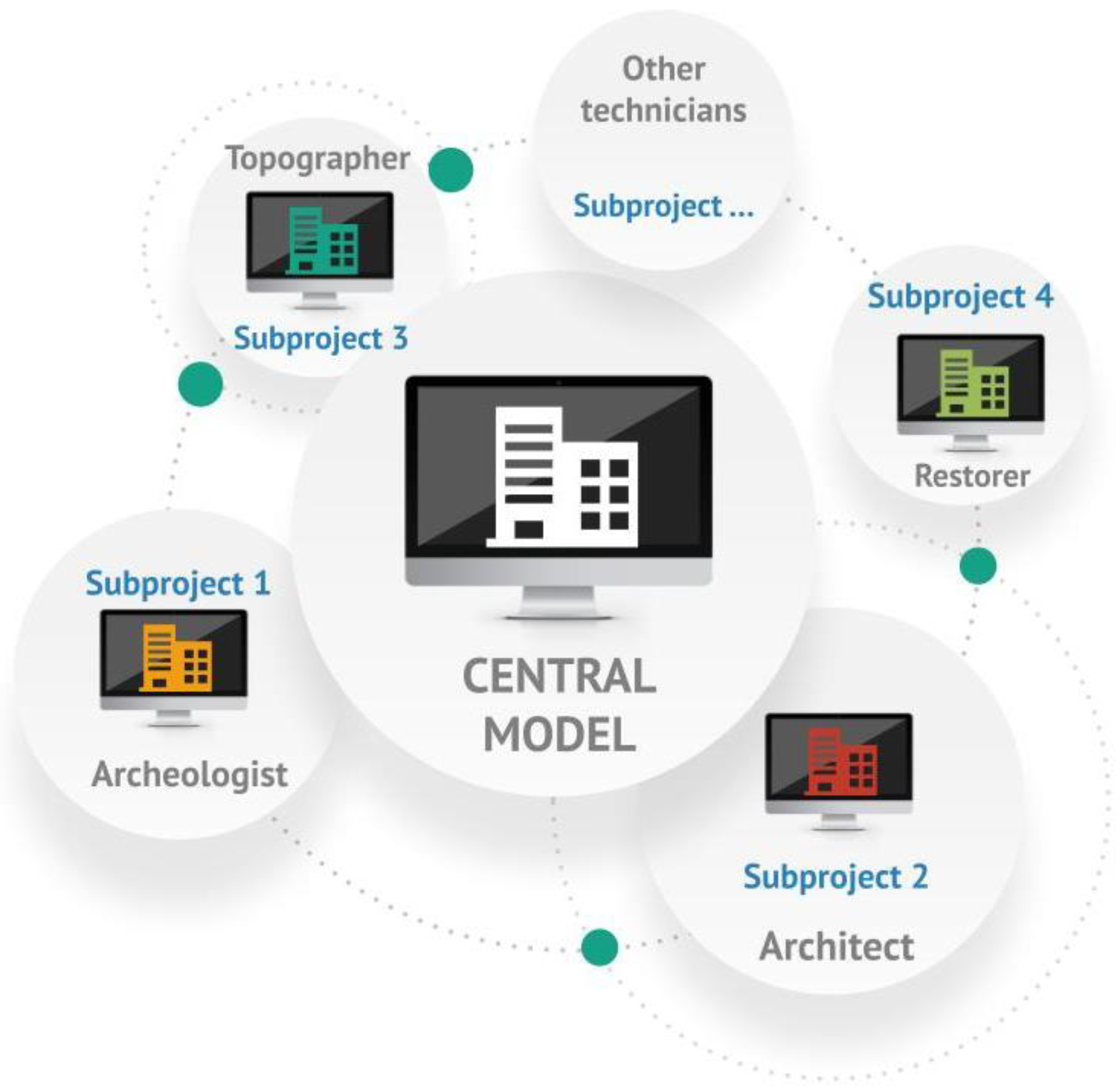
The creation of a HBIM Common Data Environment between the University of Extremadura and the Consortium of Mérida for the real-time consultation of models and information related to heritage.
2.1
The integration of a BIP (BIM implementation plan) at both institutions as a BIM implementation guide for virtual reconstructions.
2.2
The creation of 6D models of the specific settlements with three types of highly accurate non-invasive techniques complementing the historical and archaeological work of the team.
The first phase of the project, due to its relevance within the project and the need for its own conclusions and results, has been considered as a complete investigation in itself, and it is this phase that is presented and analysed in this article.
To achieve the objectives of this research within the global project, an analysis was carried out to identify the impact of tourism on cultural assets and the importance of a balance between their conservation and tourist use, always bearing in mind the principle of the sustainability of mandatory heritage for its optimal conservation for future generations.
Additionally, in this completed phase of research, protocols were established for interdisciplinary work that streamline the methods of analysis, diagnosis, intervention, and the dissemination of heritage. Finally, the application of non-invasive techniques and technologies in heritage management to offer a completely new, accessible, but above all sustainable vision of the monuments for their conservation. The protocols were carried out on the basis of small tests on pilot sites of manageable size and location, whose data collection and management allowed us to detect, control, and resolve errors; seek agile alternatives; and check the effectiveness of the method. These protocols will serve as the basis for the future development of larger-scale virtual models for the overall research project.

1.2. Research Team

The research team was a multidisciplinary team made up of experts in the fields of cultural heritage, with its management and dissemination being their main activities. This team has very advanced technical profiles. From the University of Extremadura, there are architects with expertise in the fields of tourism and heritage, civil engineers with experience in surveying and BIM technology, and advanced technical support including a physical engineer who could perform particular technical tasks and data collection in situ that require this experience and expertise. In partnership, the Consorcio of Mérida provides the archaeologists and restorers, who provide the project with all of the necessary information on the archaeological studies and the conservation state of the monuments.
The work presented in this article was carried out by the authors, who are members of the project research team.

1.3. Definition of the Project Context: The City of Merida as a Pilot Site for the Research

The city of Mérida, chosen as the reference for the project and for this research, is an archaeological site in itself and a monumental complex that was declared a World Heritage Site by UNESCO in 1993. This city has at its feet a vast Roman archaeological site, one of the most important in the Mediterranean, and still preserves the legacy of all the people who passed through the city.
Today, much is known about the Roman city of Mérida. In the second half of the first century AD, it had an urban layout of just over 70 Ha and a walled perimeter of some 3952 m; a Forum of the Colony and the forensic complexes linked to it occupied an urban area of some 39,826 m2, almost 4 ha, which, added together, compared only to the public areas of the theatre and amphitheatre (35,000 m2) and the Provincial Imperial Worship Complex (18,047 m2).
Currently, the site of the city of Mérida is a great heritage offer that makes it a first-class tourist attraction. The most outstanding monuments are the Theatre and the Amphitheatre, however, there are other sites of interest such as the house of the Amphitheatre (recently opened to the public), the Temple of Diana, and the portico of the Forum (whose foundations run through much of the current city). Other monuments of great value and tourist interest are the Arch of Trajan, the Roman Bridge, the Roman Circus (one of the most impressive due to its good condition and size), and the Aqueduct of Los Milagros, which still preserves pillars and arches with a height up to 27 m. As can be seen, the great monuments are Roman public buildings, which is why the project is part of this period and condition [1].

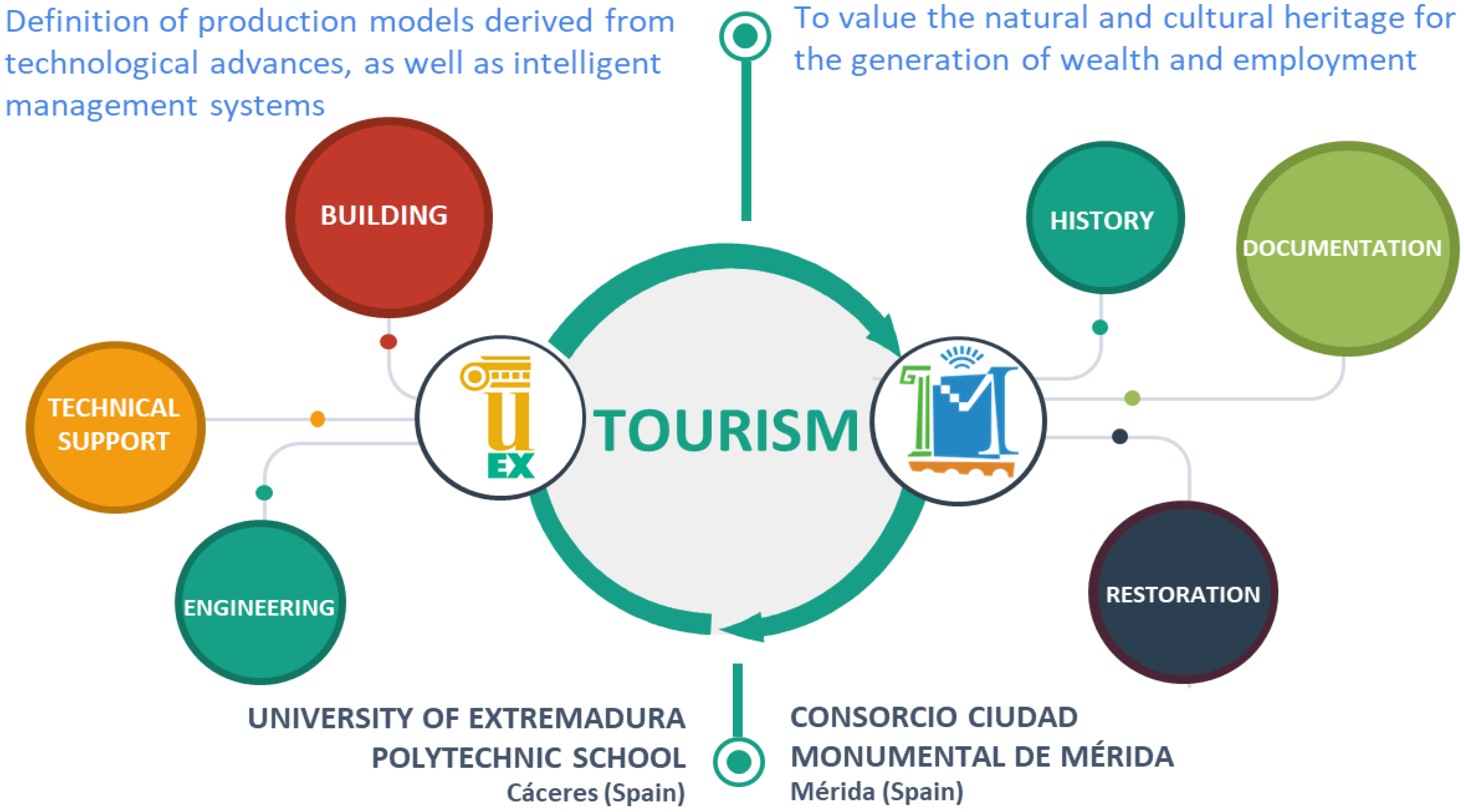
1.4. Collaboration between Institutions

The UEX-Consorcio of Mérida collaboration responds to one of the aims set out in Law 10/2010 of 16 November, on Science, Technology and Innovation in Extremadura, as it stimulates cooperation between two important agents in research and innovation based in Extremadura, and establishes a clear example of connection between the disciplines of technological and humanities. This has meant great advantages in the development of the research, as the Consorcio has provided a large amount of previous information on the heritage of the city, which, together with the use and collection of data with the technology and techniques from the university, has obtained unique results that have never been applied to World Heritage cities.
This collaboration has helped to create a team with technicians from different disciplines working in heritage management (archaeology, restoration, architecture, topography…) (Figure 2). In order to ensure good and efficient communication between the two institutions, a Common Data Environment (CDE) was created with protocols and the standardisation of information, both existing and new information that had been generated [2].

1.5. Applicability

This article contributes to generating a new perspective on the management of heritage as a tourism resource. We start from the premise that cultural tourism is today an economic engine that favours the development of urban and rural areas, however, we cannot deny the obvious, which is the impact that this has on the conservation of heritage assets [3,4,5].
Since 1972, the UNESCO Convention, being fundamentally protectionist, predicted that destinations with heritage interest would attract tourism. Because of this, the negative impact on heritage began to be noticed and in 1976, ICOMOS issued the Charter on Cultural Tourism, which established sustainable strategies for tourism activity. In the 2011 version of the practical guidelines of the Convention as well as in the Manual for the Inscription on the World Heritage List, the tourism issue was addressed including a management plan that sought collaboration between heritage protection and tourism management [4].
In the development of this work, we asked ourselves the following questions: How long can certain heritage buildings withstand the wear and tear of use and abuse of their most tangible values? Is it possible to show lost spaces or spaces that existed and have disappeared, but whose traces still mark our city today? What happens to those unique spaces that are inaccessible to the general public?
To overcome all of these adversities, there has been a lot of research focused on offering new experiences beyond the typical guided visit. These activities improve the didactics [6] and understanding of ancient spaces (often difficult to visualise for experts in the field) and also combine perfectly with the preservation of heritage, as they are activities with zero impact from the point of view of the deterioration that their use may entail.
Moreover, the current COVID-19 pandemic has posed new challenges to interdisciplinary teams working in heritage tourism management in terms of dissemination and education [7].
This research develops proposals that contribute to achieving a certain balance between tourist activity and heritage conservation, from the adaptation of the monument for on-site visits to the generation of new tourist experiences with virtual visits. All of this is possible thanks to the application of different non-invasive technologies combined with heritage. It contributes to scientific research in the conservation and use of built heritage, under the principles of sustainability with its use and enjoyment.
The novelty of this article lies in the use of non-invasive tools for the integrated management of heritage, thus avoiding the negative effects that can be caused by its use. The aim of this system is, on one hand, to mitigate the impact that tourism can have on moments, and on the other hand, to provide an alternative to archaeological structures and elements that cannot be seen due to the conservation conditions in which they are found.

2. Background and Related Works

Since the end of the last century, we have witnessed a democratisation of the so-called 3D-technologies for computer visualisation in the field of heritage management. This was marked not only by a reduction in the hardware and software costs, but also by the simplification of techniques, especially photogrammetry, which previously required an enormous investment in time and training. This has led to the development of a large number of projects aimed at restoring, reconstructing, or digitally recreating parts of the preserved heritage [8,9,10].
This growth brought with it the need to develop protocols and techniques that would guarantee the scientific accuracy of the models generated. As a result, recommendations were drawn up in the London Charter (2006), which were later developed in the Seville Principles (2011). Some of these principles, which must be addressed by the projects, are interdisciplinarity, complementarity, authenticity, historical accuracy, and training, which aim to provide virtual reconstructions with content that goes beyond the simple model and provide interested users with the ability to validate their virtues and defects.
It is important to note that the protocols developed in this project are not intended to become mere isolated efforts, destined to be forgotten or obsolescent in a short period of time, but rather the opposite. The documentation generated will serve for the development of work carried out by different disciplines involved in heritage management and can be used for the development of architectural projects [11] and monument restoration and conservation projects [12,13].
In this project, which deals with computerised reconstructions of heritage [14], the aim is to use tools and techniques that guarantee authenticity and historical accuracy such as the evidence scale of the Byzantium 1200 Project, theoretically developed in the scale of historical-archaeological evidence. Through the use of this and other techniques such as the extended matrix, the language associated with heritage will be transferred to the digital environment, making it possible to create a standardised system that can be interpreted and repeated by other heritage cities [15,16].
Therefore, the documentation generated during the project will follow both the principles and standards proposed by the reference standardisation bodies for data management such as the Open Geospatial Consortium or the INSPIRE directive as well as the premises for the computerised documentation of monumental spaces set out in the London Charter (2006) and the Seville Principles (2011).
In Spain, we are not aware of work similar to that proposed here, although it is true that virtualisations and/or virtual tours have been carried out for large monuments (e.g., the Generalife) [17,18,19,20], but without the rigour of a methodology compatible with the technical and scientific world, and without creating protocols that are really applicable to other settlements.
At the international level, Italian research groups are working on 3D survey techniques exclusively in the field of heritage [21,22,23]. The DICAr (Department of Civil Engineering and Architecture of the University of Pavia), for example, in Pavia and the Laboratorio di Rilievo in Florence, are at the forefront of this issue and our idea is to collaborate with them in some way (attending conferences, visits, exchanges…), but it is true that in these cases, the survey is in itself the objective, which is the most common and what we have encountered in other research groups along this line [24,25,26,27,28].
In our case, the survey is one more tool we can use to reach our final objectives, as what we are looking for is not only a graphic adjustment with reality, but also for society to experience heritage in a different way, to approach it in a different way, and to be able to understand an archaeological settlement from the time it was founded until the present day [29,30].
On this point, the approach of this project is truly new, although it is true that all of the tools used during the project, despite being innovative and highly technical, have been tried and tested extensively by the scientific community [31,32,33].

3. Materials and Methods

For the methodological process, tasks were established that focused the research on generating new strategies for the sustainable development of cultural tourism and its conservation. These tasks are as follows:
  • The study and analysis of the impact of tourism on the city of Mérida and its effect on archaeological heritage.
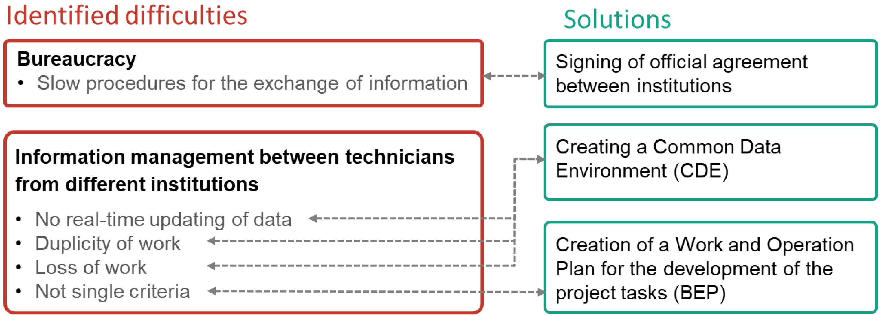
  • The creation of a Common Data Environment between the University of Extremadura and the Consorcio of Mérida that favours communication between the specialists involved in heritage management.
  • The protocolisation of the use of non-invasive techniques in tourism development projects in the city of Mérida, in order to adapt them to both on-site and virtual visits.

3.1. Phase 1: Previous Analysis of the City as a Tourist Attraction

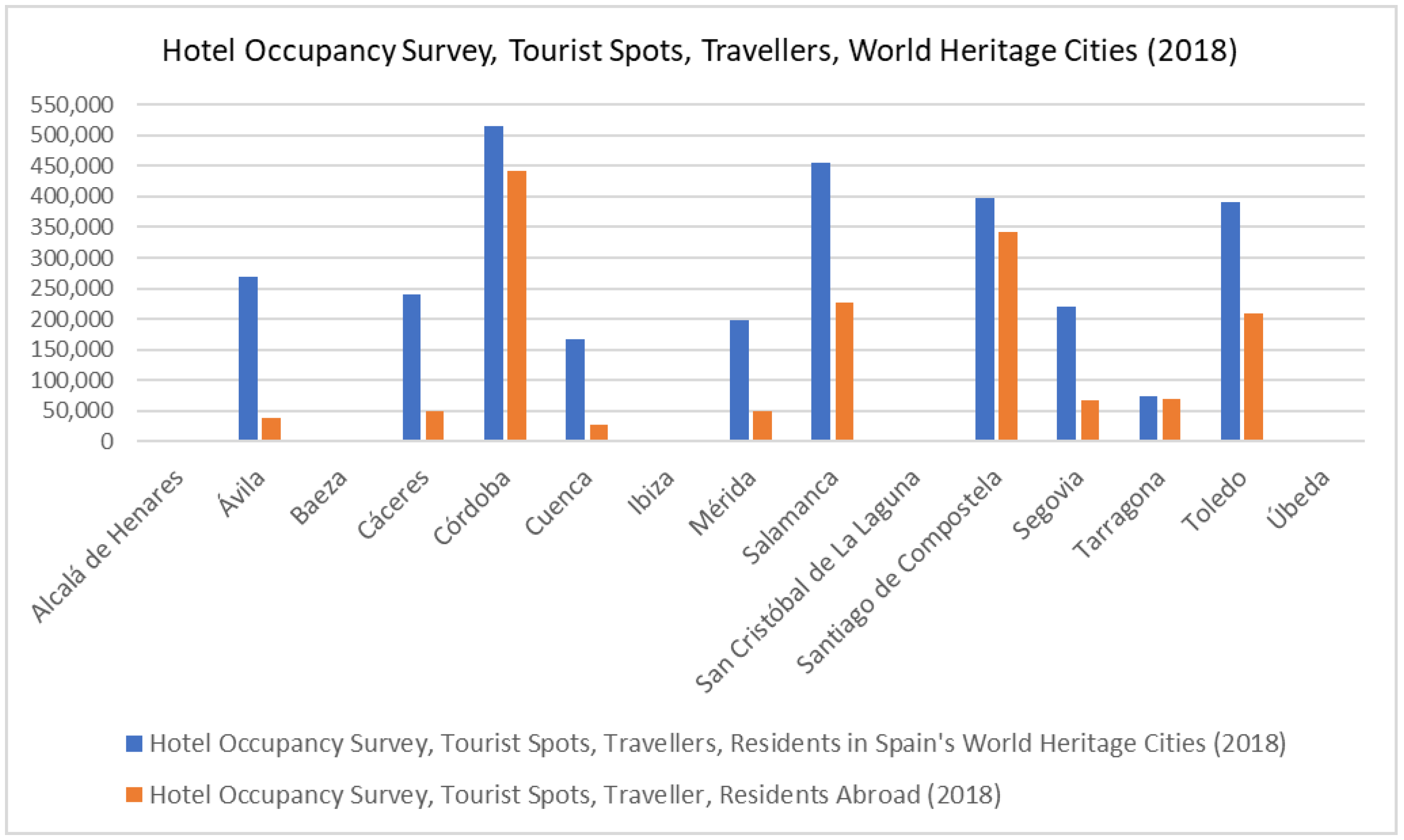
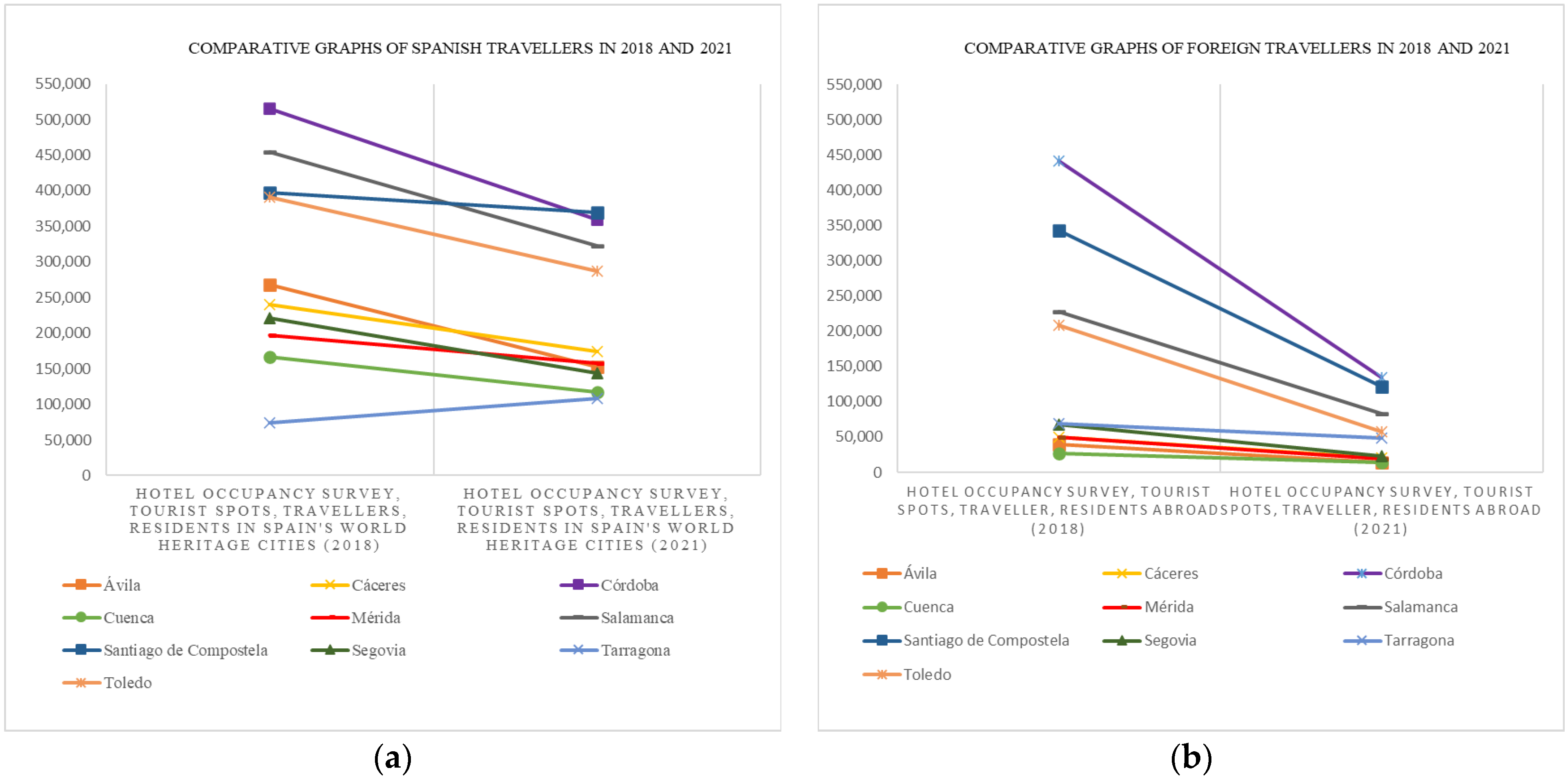
Analysis of Data on Tourism Activity in Mérida

This preliminary analysis of tourism activity in Mérida was based on the data generated by the National Statistics Institute (INE) and the data published in the Report on Urban Tourism carried out by the University of Extremadura and the Dirección General de Turismo of the Regional Government of Extremadura [1]. Thus, the researchers’ task was to conclude and interpret based on these existing data. The methodology followed and the data obtained were considered valid, taking into account the technical solvency of the institutions that carried out the study on tourism in the city. We used as the basis the data taken from the National Institute of Statistics (Table 1).
With these data, we realised that the number of overnight stays in the city has increased, which means that Mérida receives more tourists who travel specifically to visit the city, reducing the number of “passing through tourists”. Of all the tourists that the city received in 2018 (287,208 people), 23% (65,161 people) were foreigners. These data from the study carried out in Mérida have been put into context with other World Heritage Cities in Spain, for which we carried out a comparative analysis between the different cities in order to contextualise the data within the tourism panorama on a national level. This comparative analysis was carried out on the basis of data provided by the National Statistics Institute (INEN) (Figure 3).
As can be seen, despite the fact that the data extracted from the analytical study of tourism in Mérida seem encouraging, in which a growth in tourism in the city can be perceived, if we compare it with other heritage cities in Spain, it is still at the bottom in terms of the number of visitors both nationally and internationally.
Another analysis carried out was to observe what impact the COVID-19 pandemic has had on tourism in Spain’s World Heritage Cities. In the following graphs, we can see a comparison of the number of tourists received by the cities before and after the pandemic (2018 and 2021) (Figure 4).
In this analysis, we studied the data for all cities to see the extent that the pandemic has affected each of them. In this way, we can see whether the decrease has been generalised or uneven, and can conclude on whether other factors may have influenced the change.
In the case of Mérida, we can see that within the 15 World Heritage Cities, it ranked in sixth place (not counting Alcalá de Henares, Baeza, Ibiza, San Cristóbal de la Laguna, and Úbeda, for which there are no data in the INE). In general, Mérida is not one of the cities that has suffered the least loss of foreign tourists due to the pandemic.
A generalised decrease was observed in the cities in 2021, however, Santiago de Compostela decreased the least, and in contrast, Tarragona suffered an increase. Mérida ranked third city among all of the cities that had lost the least number of tourists, which is a very positive figure. Currently, the data available for 2022 are more encouraging, and it is expected to reach the values prior to the pandemic in the short-term, which would mean a recovery in tourism.
As we can see, it is necessary to continue working to promote tourism in the city of Mérida without harming the heritage conservation. Hence, our contribution is to generate alternative strategies with the use of new technologies.

3.2. Phase 2: Definition of a Collaborative Protocol within an ECD (Common Data Environment) That Will Be Developed throughout the Project

The Consorcio of Mérida and the University of Extremadura complement each other perfectly to develop the research project. On one hand, the Consortium provides all of the documentation on the city’s monuments, and on the other hand, the University provides the use and collection of data with non-invasive technology and techniques that provide optimal results, which ultimately favour the sustainable management of heritage.
In this collaboration between institutions, we encountered some difficulties to which we have responded by developing the work described in this article (Figure 5).
First, the transfer of data and information involves a series of bureaucratic procedures that can slow down and complicate the research process. This has been resolved through an official agreement between both institutions under the framework of Ley 10/2010 de 16 de noviembre, de la Ciencia, la Tecnología y la Innovación en Extremadura. This agreement allows for the transfer of data and information exclusively for research purposes related to the research project.
Another aspect that was considered is that, when working in a team, each member generates their own documentation that must sometimes be shared with others. With traditional work systems, it is not possible to access updated information in real-time, and sometimes a duplicity in information can be generated, which makes teamwork inoperative. As a solution to these problems, a Common Data Environment was created that allows us to access the information in real-time, with updates made at all times by each agent involved in the process.
Finally, another of the problems detected was the lack of a single criterion to generate information, and this has been addressed by creating a Work and Operation Plan, which defines the criteria to be followed when working with and generating research data.
The methodology followed to respond to each problem detected is explained below, thus favouring the smooth development of the work.

3.2.1. Creation of a SERVER COMMON to Both Collaborating Entities, So That Any Progress in the Research Can Be Transmitted in Real-Time to Any Member of the Research Team

In order to efficiently coordinate the work between the institutions, it was important to create a standardised Common Data Environment.
The creation of a digital information system allowed us to combine resources in a single model that contained all of the updated information, whose data are standardised and open, so that all the agents involved in the research process can exchange, modify, implement, and share information.
  • Server Structure
We will work with a central server where all other computers (local computers) are connected directly to that central point, generating a network connection in which all communications are necessarily undertaken through that point.
With this working structure (Figure 6), we have a central model, which for protection, only the manager of that file has access to, which is stored on the central computer, and all other users can work on the central model independently, but collaborate simultaneously, from a local copy on their computer.
An accelerator will be installed on all computers to store all changes that occur in the model simultaneously, so that users will have quick and immediate access to the updated model.
In order to work efficiently, a protocol with action guidelines was drawn up to ensure that the cooperation between different people within the project was efficient, so that inconsistencies could be detected and solved as soon as possible.
The project was divided into different sections by disciplines, which we called sub-projects, and a system of permissions and properties of this information was established and assigned to each user, so that the intellectual property of the documentation could be preserved.
This system allowed us to access the data generated in real-time and completely updated, which enabled us to see the process of each work and thus avoid duplication or loss of information.

3.2.2. Drawing up a Work and Operation Plan for the Development of the Project’s Tasks

In order to define the work plan, the following methodology was followed, which can be extrapolated to any other institution in charge of heritage management.
This work plan is composed of the following phases:
  • Establishing a strategy
Previously, the current structure and system of work were studied, in order to analyse the real efficiency of the development of the work. Therefore, it is essential to carry out a prior analysis of the reality, the process of which has become a protocol, so that it can be carried out in other institutions.
Subsequently, certain phases were established and with them, clear deliverables so that the implementation could be as effective as possible (Table 2).
  • Selection and configuration of the tools to be used
The software used will be chosen by analysing the level of knowledge of the different tools among the Consortium’s employees. It is essential to maximise the resources that the Consortium has and to identify areas for improvement, in order to establish a data flow system in the project, adjusted to the current situation of the CCMM.
In the process of implementing the tool or a workflow, the following must be specified:
  • To describe the storage of the model in the programme as well as the delivery format of the model;
  • To establish the model or part of the model for each discipline;
  • To mark what minimum information the model should have;
  • To describe the quality control model;
  • To establish the coordinates of the project.
Archaeologists carry out excavations all over the city. It is very important to establish a common coordinate system (UTM) in order to georeference each element that appears in any of the excavations. Therefore, it is necessary to ensure that the initially configured system is valid for all of the works to be carried out.
  • Data management system
The digital data platform to be used was defined by considering the accessibility to all project technicians, where in this case, the following steps were followed:
  • The structure of the work folders and files. A template was established describing the structure of each of the folders where all the project data will be stored (Table 3);
  • The standardised nomenclature for the folders and files;
  • The print style;
  • Input data collection: Data collection was classified by themes or disciplines. All data must be geo-referenced and sufficiently defined to be able to develop the model.
  • Protocolisation of the formats for data exchange.
One important aspect was to specify which files will be delivered to particular disciplines for reference as well as which files will be delivered in the end.
  • Communication methods and use of standardised tools.
A communication system was established in advance, setting up structured meetings to evaluate, plan, and concretise the tasks of the different work phases. A system of cards (Table 4) was established to structure the communication between the project participants.

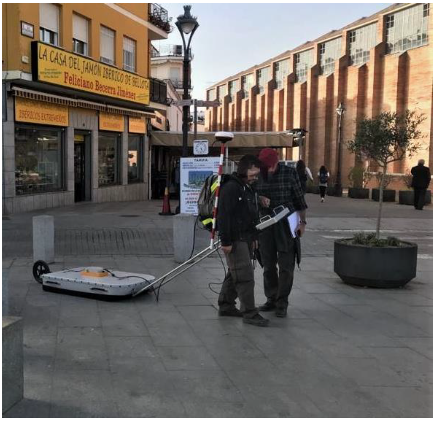
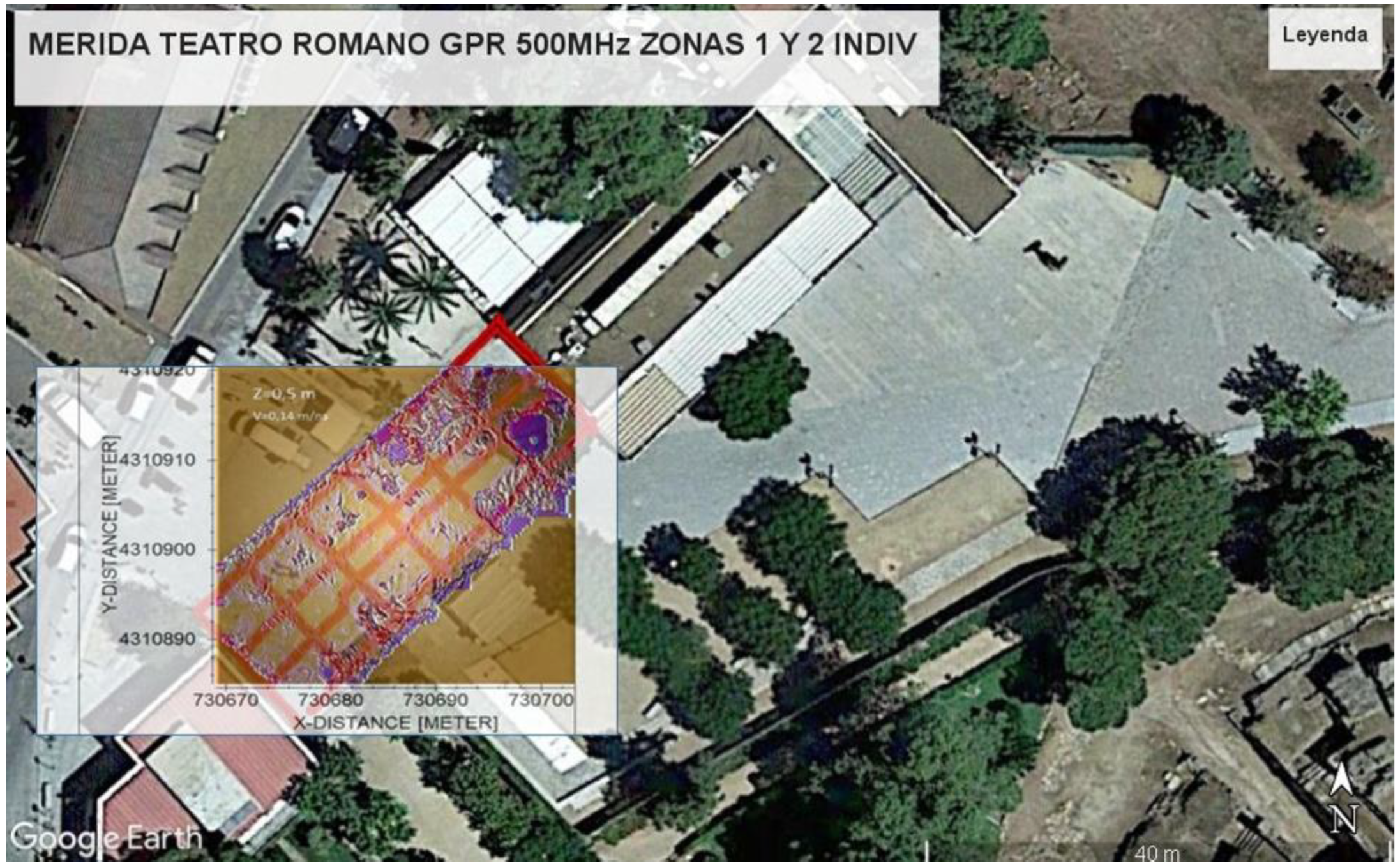
3.3. Phase 3: Use of Non-Invasive Technologies and Instrumentation for Heritage Management

For cultural tourism to be sustainable and not pose any problems for the conservation of monuments, it is necessary to adapt them to their intended use.
In this phase of the research, several techniques are proposed, which through non-invasive tools can help us to promote the adaptation of monuments for on-site visits, but also generate new experiences through virtual visitation, which could be an alternative to show spaces and elements that cannot be shown due to conservation or accessibility problems.
Therefore, in this phase, we will see how to boost and increase the supply of cultural tourism in a sustainable way without affecting the conservation of these monuments [34].
Different strategies for the sustainable management of heritage for tourism use can then be proposed, using tools that are non-invasive with the monument.
It should be noted that the technologies themselves, although cutting-edge in their field, do not represent the innovation of the project, but it is the use to which they are put and the very novel applications that are proposed that will help to achieve the truly transcendental results of the project.
This article presents the protocols that have been created from the trials at easily manageable pilot sites, thus allowing for better error control and alternative solutions to obtain an optimised and operational method that will serve as the basis for the development of larger-scale virtual models that are expected to be developed in the next phases of the research project.
  • Preservation of buried archaeological features using GPR
In disciplines such as archaeology, it is very important that there is good planning in order for excavations to be sustainable and profitable. This is why it is necessary to determine between what is a priority and necessary to excavate and what is not.
At present, it is not feasible to excavate all of the areas where archaeological remains are presumed to exist, as this would require a high cost of maintenance and conservation due to their exposure to deterioration caused by atmospheric agents and use [35]. This ends up becoming a problem of economic resources, as is the case at archaeological sites such as Pompeii.
On the other hand, we know that technologies are advancing and becoming more and more technological, so it is hoped that in the future, it will be possible to obtain more precise data and information from archaeological excavations.
With this premise, it is important to leave archaeological reserve areas unexcavated, thus ensuring that any remains that may be found are protected and preserved.
Nowadays, not excavating means not having the data or knowledge that is sometimes essential to be able to complete the existing information, or to resolve certain doubts or hypotheses.
In the development of the research project, where we hope to generate virtual models with as much information as possible, we considered that part of this information will be provided by GPR technology, so that in areas that are not excavated yet, we can intuit whether or not there are archaeological remains.
“The possibilities that GPR offers for the study of cultural heritage are quite attractive, its use in the prospection of historical sites and potential archaeological sites allows for a bridge of interconnection between documentary research and the understanding of human processes that took place in the past” [35]. This ground penetrating radar (GPR) technology is a non-invasive geophysical method for the study of the subsurface. It is based on the emission, propagation, and reception of electromagnetic waves through the ground, which translate into patterns of anomalies, densities, etc. at given depths.
It is a technique that is widely used in many fields and, as we can see, since 2012, it has been utilised at archaeological sites, however, in this case, the use of the method is not the objective in itself, but a tool for the three-dimensional survey of buried spaces that are currently impossible to bring to light and therefore 100% inaccessible, but reveal great historical discoveries and explain construction periods, sociologies, architectures, and cities, which are the basis of everything known to date about our civilisation.
Data have been obtained in which the difference in the compaction of the different layers can be observed, which allows us to intuit the stratigraphy of the terrain, however, more precise data required for archaeological activity, the relationships between the construction elements, differentiation of periods, etc., cannot obtained. In this way, we have found the usefulness of this technology lies in terms of knowing whether there are remains or not, which would mean that the virtual model to be developed would reflect where there may be remains and where there are not, which would mean greater efficiency in the future when it comes to archaeological excavations, being able to prioritise areas where data can certainly be obtained.
In the first phase of the research project, we implemented GPR in the Margarita Xirgu Square in Mérida (Figure 7), taking advantage of the fact that the square was going to be refurbished.
This allowed us to establish a management strategy and methodology to collect and interpret the GPR data obtained in order to subsequently implement them in the model. As excavations were also carried out as necessary for the development of the works, it allowed us to contrast the resulting information with the previous interpretations.
We used GPR PROEX equipment from MALÅ Geoscience, with two antennas of 500 and 1200 MHz nominal frequency. The use of these two antennas allows for different spatial resolutions and different maximum depths to be achieved, as these depend on their frequency. Specifically, with the 500 MHz antenna, we could reach depths of approximately 5–6 m, with a resolution λ/2 = 0.13 m, assuming a displacement velocity of the waves in the subsoil of v = 0.13 m/ns. With the 1200 MHz antenna, there can be maximum depths of between 2–3 m, with a resolution λ/2 = 0.06 m.
The methodology followed for the use of this device was as follows:
  • Prior calibration of the equipment, using the test bench built at the Polytechnic School of Cáceres, which consists of an enclosed area in which different strata of soil (sandy, slate, and granite) were distributed and different objects of known dimensions and locations and depths (pipes, cables, walls, etc.) were buried.
  • In each settlement of interest, surveys were carried out in orthogonal directions to each other, in order to have a grid of radargrams that would allow us to carry out an adequate interpretation of these and to elaborate a model of the subsoil structure at each site. For a better visualisation of the radargrams, different filters were used during processing to improve the signal-to-noise ratio: the band-pass filter, gain filter, and background subtraction filter (Figure 8).
Thanks to the use of this tool, we could detect archaeological remains, which allowed us to obtain prior information before excavating and in this way, manage the archaeological in a sustainable and profitable way. Even in architectural projects, it will allow us to adapt the designs in the previous phases, thus avoiding placing foundations in areas where structures are expected to exist.
In addition, this information can be introduced into the digital model that will have all of the data collected.
  • Data collection through the use of UAV and RPAS technologies
Drones are a cost-effective alternative to photographic flights with aeroplanes [36,37,38,39], in other words, the technique and methodology are not new, but the application to the survey of existing archaeological settlements for subsequent manipulation and dissemination is a truly innovative use of the method.
The UEX team has tested the method in several projects, an example of which is the “Extremadura Passage Works Research Project”, where drone flights have been crucial in carrying out surveys and pathological detection in completely inaccessible places that had never been seen with precision or previously studied [10].
The aim of the research project is to carry out a complete virtualisation of the Forum of the Colony of Emerita Augusta. Obviously, covering this from the beginning can be complicated, so a gradual data collection has been planned.
In the first phase, it was carried out by establishing the so-called Portico of the Forum of Mérida as a pilot site (Figure 9). The methodology established and the results obtained are presented below.
This allowed us to obtain a survey of the monuments that will help us to disseminate the heritage information and generate new experiences in the tourist offerings of the city [17,40,41].
First, it has to be taken into account that with drones, we cannot directly carry out a photogrammetric survey [42,43,44,45,46], Instead, we used superimposed photographs with points in common at different angles both transversally and longitudinally and, thanks to stereoscopy, we measured the distances, altitudes, and elevations.
After the work was successfully carried out by the research team, it was concluded that there are three steps to be followed in a correct UAV survey methodology:
-
Inspection of the study area: Where the morphology and geometry of the settlement or topography (if the buildings are underground) is studied.
-
Support and ground control points: In order to take valid photographs for the purpose of a 3D survey with drones, GCP and “Check Points” (support and ground control points) are needed to guide the work to a single reference system. To achieve the accuracy and precision, we require a digital reconstruction work such as the one we wish to tackle, for which we will need a differential GPS or RTK system.
-
Drone flight planning and execution: Drone flights must be carefully planned by taking into account the number of flight lines, the speed of the drone, the flight height, and the percentage of overlapping images, among other things.
  • Creation of the virtual model
Based on all of the data collected, both from the survey and from the archaeological reports, a virtual model was created with all of the information [47]. It should be kept in mind that in the process of making the model, the presence of archaeologists is essential in order to verify each of the reconstructed elements at all times. A colour code was created to indicate which parts are original and have been preserved on site, which are original and have been moved to their original location (anastylosis), which parts have been materially reconstructed, and which have been virtually reconstructed (these parts will also have a lower level of detail) (Figure 10). At this point, the work of the archaeologists, who will carry out studies of the walls and extrapolate the information from the excavation reports to the models, is fundamental.
This system was created in this model of the Forum Portico and will be extrapolated to the other models included in the overall research project. With this system, the principle of authenticity is also fulfilled in the virtual model, so that the user can identify each of the parts of the model. The archaeological information on these remains has been published, from which all the data were extracted [48,49,50].
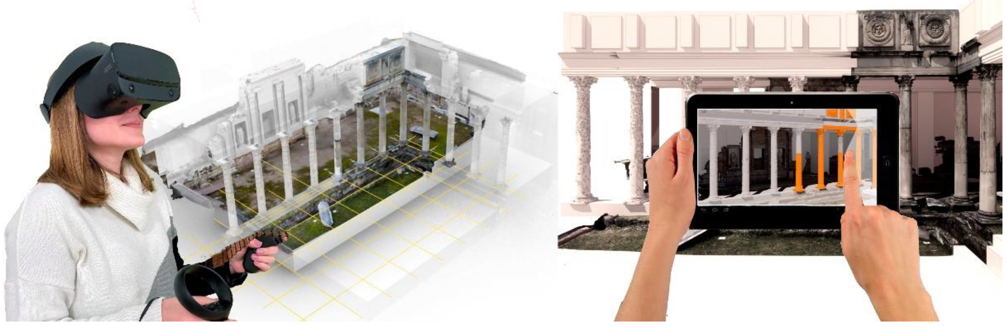
  • Virtual tour with the use of VR and VRA technologies
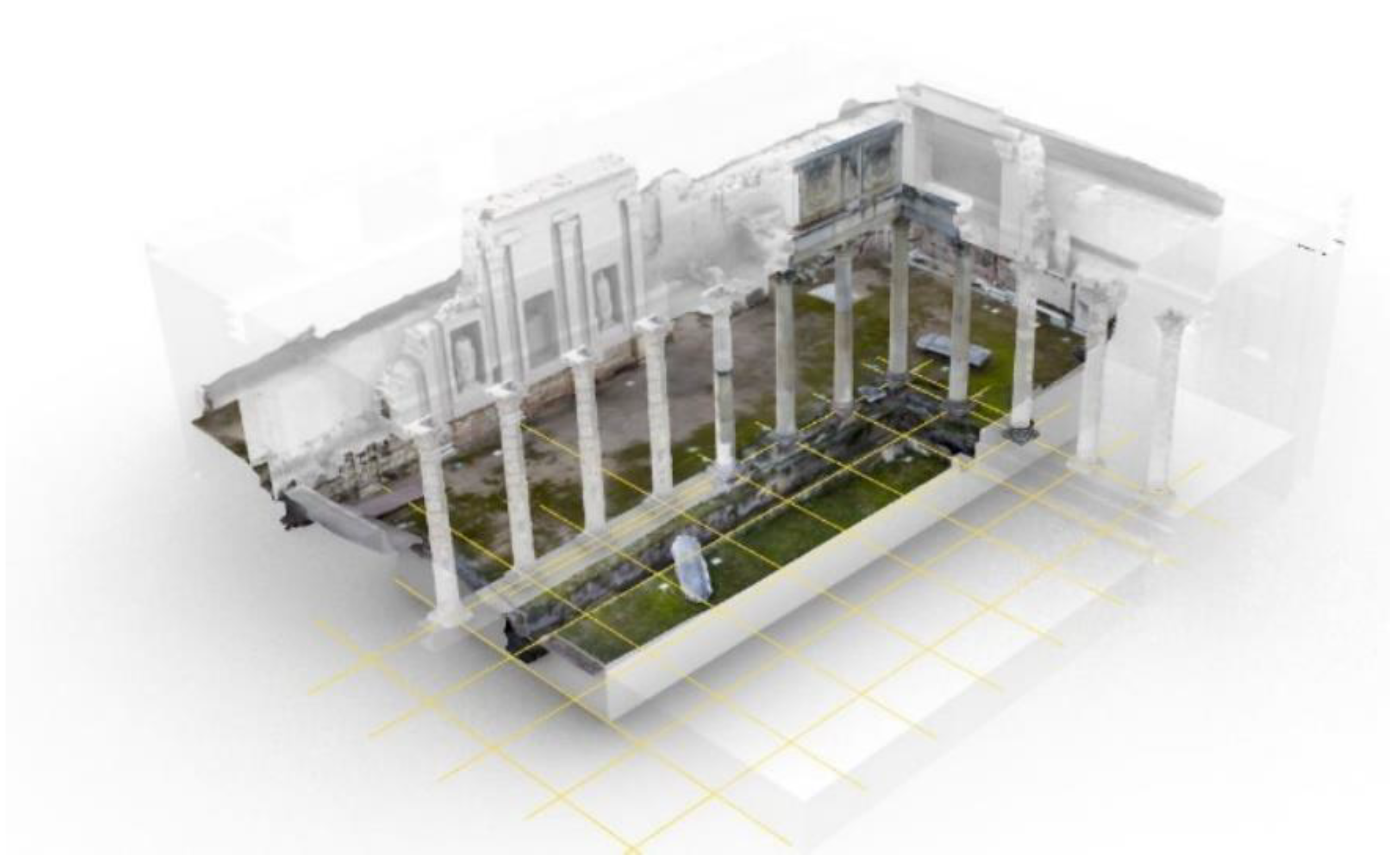
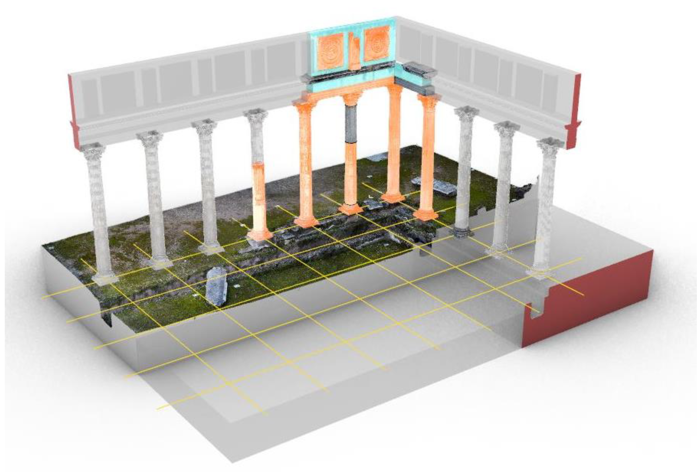
A direct application of the reconstructive model obtained will be the dissemination of heritage through VR and AR technologies (Figure 11).
This technology needs two main environments to exist: the user environment and the virtual environment. Both environments communicate and exchange information through the interface.
Among the many types of virtual reality that exist (simulators, projection of real images, etc.), the project contemplates immersion in virtual environments, which consists of establishing direct brain–machine communication. This connection requires a “virtual space”, where the only limits are the capacity of the computer platform, the quality of the VR glasses, and, most importantly, that the available content offers great possibilities of interaction with the user [40].
The application of virtual technology has been crucial in the teaching and learning of inaccessible places in other fields, for example, in medicine, where students can interact with all of the anatomical structures (muscles, bones, nerves…). In the same way, students of building, archaeology, and history could interact with all of the layers and constructive structures of a reconstructed Roman public building, thanks to virtual reality.
This technology also has certain drawbacks that the scientific community is currently working on, which we will consider during its implementation. First, the creation of content is individualised and personalised, and therefore very time-consuming and laborious.
On the other hand, this technology is effective for use in specific situations and not in a generalised way, as this experience isolates the user from the existing environment, which could have the opposite effect where the main objective is for people to relate and interact as a group.

4. Results

The results obtained from this research are framed within a three-year-long global project. During this time, the aim is to obtain technological development and innovative work processes in the field of activities promoting new cultural communication formats, between different administrations, and between administrations and technicians. On the other hand, it also aims at obtaining extensive heritage digitalisation and at creating virtual cultural environments as well as incorporate experimental scientific information, which, while ensuring its preservation, will enable aa deeper knowledge of the cultural assets and greater identification of society together with its own heritage.
Thanks to this research, a significant part of the objectives foreseen by the project have been fulfilled. Within general objective 1, specific objective 1.2 has been achieved, which has been to create a Common Data Environment between the University and the Consortium. General objective 2 has also been fully met, with the creation of a BIM protocol and the standardisation of virtual models. Thanks to this, subsequent work will continue to carry out the digital dissemination of heritage in the city of Merida.
First, preliminary research on the influence of tourist activity in Mérida, and therefore on its heritage, was performed. This study has reached conclusions that justify the importance of carrying out good sustainable heritage management, together with its promotion and dissemination under the principles of respect and preservation.
Second, a communication infrastructure was established to guarantee the effectiveness of the work produced by the multidisciplinary team inside the research team, which can be extrapolated for use between administrations. This means ensuring the transfer of the data, documentation, and results obtained in the work that focused on heritage manage and preservation. This work fulfils the initial commitment to transfer results between research teams and public administrations for their development in specific applications, for scientific, technical, or artistic work, or for specific training activities. This platform will allow us to ensure that the results obtained in future works are available to the entire population, either being tourism service companies, researchers, or the general public. In addition, it will generate a knowledge foundation on which to build a region in which the portfolio of technical and tourism services will be expanded.
Third, this research has produced a proven methodology and working protocols for monitoring and tracking these assets through a comprehensive process of documenting and generating heritage databases in multiple formats and using proven, accurate, and novel non-invasive technologies and tools.
In this sense, GPR technology has been implemented with the aim of performing archaeological excavations in a sustainable way in the city. This avoids leaving archaeological remains uncovered and in constant state of degradation due to the effects of atmospheric factors. It also ensures, from the design process of the projects, that the possible foundations of contemporary structures do not affect the archaeological remains that are buried.
The use of UAV and RPAS technologies was also implemented. This technology is very effective in the collection of data for photogrammetric surveys. It is also useful from the point of view of heritage maintenance and conservation as it allows for the periodic monitoring of areas that are difficult to access.
The use of VR and AR technologies to visualise heritage from previously generated photogrammetric surveys has also been standardised in protocols.
All of this research will serve as a basis for the future development of the virtual dissemination of heritage that will enable each user to interact with cultural heritage directly, by being able to approach and see areas or details that are inaccessible, or even hidden elements that are not ready to be accessed due to preservation and maintenance concerns. With this system, we can generate a new experience in tourism, which is the offer of an extended visit not only in situ, but also from anywhere in the world, as it is completely accessible without depriving the population of being able to see these places regardless of the physical circumstances of both the user and the heritage element.
With such techniques, we can obtain immersive and interactive experiences in which the visitor comes into contact with the culture, the symbolism, and the minds of past societies [24,51].
From the point of view of technology transfer, the achievement of the foreseen objectives will mean the incorporation of high technology into the decision-making process in the control, conservation, and dating of historical and cultural heritage, which will lead to improvements in the systems of cataloguing, documentation, and understanding of heritage.

5. Discussion and Conclusions

Our heritage is a legacy that we have received from our ancestors, so we are bound by the obligation to maintain and conserve it in order to leave it to future generations. Every day, efforts are being made in this direction, and methods have been devised to assist not only in the preservation, but also in the knowledge and study of heritage assets.
In this research, the strategies marked by these principles were outlined. Nevertheless, these also have great advantages in many other aspects.
From an economic point of view, having a database accessible to all (administrations and technicians) guarantees better conservation of our heritage by having wider control over the needs of these assets and being able to manage the administration and financial resources with more criteria, guaranteeing its optimisation. This makes it possible to preserve our heritage with smaller budget allocations.
From a social approach, a universalisation of our heritage is ensured thanks to new technologies. These first steps in this universalisation will mean that the possibility of visiting a work of art, a bell tower, or a church will not be limited either by the physical conditions or by distance. In this way, people with reduced mobility due to age or other conditions will be able to see what only used to be possible to people without limitations such as a bell tower. On the other hand, each time we will be able to travel further and beyond, as there will be no borders to stop people from visiting a building. This universalisation ensures that we all know our past, regardless of where we live and the distances involved.
From an educational point of view, this interaction will allow any child to access a monument from their school with minimal investment.
This research is the start of an international scientific breakthrough in the fields of architecture, art, and archaeology. In particular, the techniques developed can be integrated into systems that accurately reproduce as well as detail any structure or building for subsequent morphological analysis, thus taking advantage of all of the resources provided by the techniques used.
In short, with the methodologies proposed in this article, we can gain efficiency in the management of archaeology, restoration, architecture, etc. projects and, in addition, it will contribute to the dissemination and popularisation of heritage. A wide range of possibilities is opening up before us, which will have to be further investigated and implemented.

Author Contributions

Conceptualisation, P.A.C.F. and A.R.M.d.l.P.; Editorial responsibility, P.A.C.F., A.R.M.d.l.P. and J.A.R.S.; Methodology, P.A.C.F. and J.A.R.S.; Validation, A.R.M.d.l.P. and J.A.R.S.; Formal analysis, A.R.M.d.l.P. and J.A.R.S.; Investigation, P.A.C.F., A.R.M.d.l.P. and J.A.R.S.; Resources, A.R.M.d.l.P. and J.A.R.S.; Visualisation, A.R.M.d.l.P. and J.A.R.S.; Supervision, P.A.C.F. and A.R.M.d.l.P.; Project administration, A.R.M.d.l.P. and J.A.R.S. All authors have read and agreed to the published version of the manuscript.

Funding

This publication was made possible thanks to funding granted by the Consejería de Economía, Ciencia y Agenda Digital de la Junta de Extremadura and by the European Regional Development Fund of the European Union through the reference grant IB20096, project “Application of VR technologies and 6D surveys for the implementation of universal accessibility in the archaeological heritage of Roman public buildings”. We also thank the funding granted by the Consejería de Economía, Ciencia y Agenda Digital de la Junta de Extremadura, and by the European Regional Development Fund of the European Union through the reference grant GR21159 (COMPHAS researcher group).

Data Availability Statement

This section is not necessary. should be excluded.

Acknowledgments

In the development of this research, we have had the support of institutions such as the Consorcio Ciudad Monumental de Mérida, which has made available to us the existing documentation of these buildings as well as providing us with access to the archaeological site. We also thank the Comphas research group of the University of Extremadura, which provided us with the material means and tools, allowing us to put into practice the proposed working method, and through the TAD3 Lab group of the University of Extremadura, which is currently developing virtual tours of the heritage of the region of Extremadura, we have managed to disseminate this heritage asset.

Conflicts of Interest

The authors declare no conflict of interest. The funders had no role in the design of the study; in the collection, analyses, or interpretation of data; in the writing of the manuscript, or in the decision to publish the results.

References

  1. Sánchez, M.S.O.; García, Y.G.; Ramos Vecino, N. Informe sobre Turismo Urbano. Cáceres y Mérida; Extremadura University: Extremadura, Spain, 2021; p. 126. [Google Scholar]
  2. Nieto-Julián, J.E.; Lara, L.; Moyano, J. Implementation of a TeamWork-HBIM for the Management and Sustainability of Architectural Heritage. Sustainability 2021, 13, 2161. [Google Scholar] [CrossRef]
  3. Pelegrín Naranjo, L.; Pelegrín Entenza, N.; Vázquez Pérez, A. An Analysis of Tourism Demand as a Projection from the Destination towards a Sustainable Future: The Case of Trinidad. Sustainability 2022, 14, 5639. [Google Scholar] [CrossRef]
  4. Ruiz Lanuza, A.; Pulido Fernández, J.I. El impacto del turismo en los Sitios Patrimonio de la Humanidad. Una revisión de las publicaciones científicas de la base de datos Scopus. Pasos Rev. Tur. Patrim. Cult. 2015, 13, 1247–1264. [Google Scholar] [CrossRef]
  5. Stoica, G.D.; Andreiana, V.-A.; Duica, M.C.; Stefan, M.-C.; Susanu, I.O.; Coman, M.D.; Iancu, D. Perspectives for the Development of Sustainable Cultural Tourism. Sustainability 2022, 14, 5678. [Google Scholar] [CrossRef]
  6. Roinioti, E.; Pandia, E.; Konstantakis, M.; Skarpelos, Y. Gamification in Tourism: A Design Framework for the TRIPMENTOR Project. Digital 2022, 2, 191–205. [Google Scholar] [CrossRef]
  7. Jurlin, K. Were Culture and Heritage Important for the Resilience of Tourism in the COVID-19 Pandemic? J. Risk Financ. Manag. 2022, 15, 205. [Google Scholar] [CrossRef]
  8. Cruz Franco, P.A.; Rueda Marquez de la Plata, A. Tad3lab Models Library. Available online: https://sketchfab.com/TAD3LAB/models (accessed on 6 September 2021).
  9. Parrinello, S. The virtual reconstruction of the historic districts of Shanghai European identity in traditional Chinese architecture. Disegnarecon 2020, 13, 18.1–18.13. [Google Scholar] [CrossRef]
  10. Cruz Franco, P.A.; Rueda Marquez de la Plata, A.; Cortés Pérez, J.P. Veinte Siglos de Patrimonio de Extremadura en ocho Puentes. Documentación Digital de las Obras Públicas; Junta de Extremadura; Consejería de Economía e Infraestructuras y Universidad de Extremadura: Extremadura, Spain, 2018; Volume 1, p. 208. [Google Scholar]
  11. Rodriguez Sánchez, C. Levantamiento y Propuesta de Accesibilidad en el Jardín Histórico de la ARGUIJUELA de ARRIBA (Cáceres); Universidad de Extremadura: Caceres, Spain, 2021. [Google Scholar]
  12. Cruz Franco, P.A.; Rueda Márquez de la Plata, A. Documentación y estudio de un “agregado” en la Ciudad de Cáceres: Análisis fotogramétrico y gráfico. In Proceedings of the Congreso Internacional sobre Documentación, Conservación y Reutilización del Patrimonio Arquitectónico, Madrid, Spain, 18–21 October 2017. [Google Scholar]
  13. Saura-Gómez, P.; Spairani-Berrio, Y.; Huesca-Tortosa, J.A.; Spairani-Berrio, S.; Rizo-Maestre, C. Advances in the Restoration of Buildings with LIDAR Technology and 3D Reconstruction: Forged and Vaults of the Refectory of Santo Domingo de Orihuela (16th Century). Appl. Sci. 2021, 11, 8541. [Google Scholar] [CrossRef]
  14. Cruz Franco, P.A.; Rueda Márquez de la Plata, A.; Cruz Franco, J. From the Point Cloud to BIM Methodology for the Ideal Reconstruction of a Lost Bastion of the Cáceres Wall. Appl. Sci. 2020, 10, 6609. [Google Scholar] [CrossRef]
  15. Ramos Sánchez, J.A. Utilización de la Metodología BIM en la gestión del patrimonio arqueológico. In Caso de Estudio el Recinto Arqueológico de los llamados Columbarios de Merida; Universidad de Extremadura: Caceres, Spain, 2021. [Google Scholar]
  16. Demetrescu, E.; Ferdani, D. From Field Archaeology to Virtual Reconstruction: A Five Steps Method Using the Extended Matrix. Appl. Sci. 2021, 11, 5206. [Google Scholar] [CrossRef]
  17. Gisbert Santaballa, A.G. La arqueología virtual como herramienta didáctica y motivadora. Tecnol. Cienc. Educ. 2019, 13, 119–147. [Google Scholar] [CrossRef]
  18. Monterroso-Checa, A.R.-V.A.; Gasparini, M.; Hornero, A.; Iraci, B.; Martín-alaverano, R.; Moreno-Escribano, J.C.; Muñoz-Cádiz, J.; Murillo-Fragero, J.I.; Obregón-Romero, R.; Vargas, N.; et al. A heritage science workflow to preserve and narrate a rural archeological landscape using virtual reality: The cerro del castillo of belmez and its surrounding environment (Cordoba, Spain). Appl. Sci. 2020, 10, 8659. [Google Scholar] [CrossRef]
  19. Parrinello, S.; Dell’Amico, A. Experience of Documentation for the Accessibility of Widespread Cultural Heritage. Heritage 2019, 2, 1032–1044. [Google Scholar] [CrossRef] [Green Version]
  20. Parrinello, S.; Morandotti, M.; Valenti, G.; Piveta, M.; Basso, A.; Inzerillo, A.; Lo Turco, M.; Picchio, F.; Santagati, C. Digital & Documentation: Databases and Models for the Enhancement of Heritage; Parrinello, S., Ed.; Edizioni dell’Università degli Studi di Pavia: Pavia, Italy, 2019; Volume 1. [Google Scholar]
  21. Paris, L.; Rossi, M.L.; Cipriani, G. Modeling as a Critical Process of Knowledge: Survey of Buildings in a State of Ruin. ISPRS Int. J. Geo-Inf. 2022, 11, 172. [Google Scholar] [CrossRef]
  22. Ramos Sánchez, J.A.; Cruz Franco, P.A.; Rueda Márquez de la Plata, A. Achieving Universal Accessibility through Remote Virtualization and Digitization of Complex Archaeological Features: A Graphic and Constructive Study of the Columbarios of Merida. Remote Sens. 2022, 14, 3319. [Google Scholar] [CrossRef]
  23. Intignano, M.; Biancardo, S.A.; Oreto, C.; Viscione, N.; Veropalumbo, R.; Russo, F.; Ausiello, G.; Dell’Acqua, G. A Scan-to-BIM Methodology Applied to Stone Pavements in Archaeological Sites. Heritage 2021, 4, 3032–3049. [Google Scholar] [CrossRef]
  24. Parrinello, S.; Francesca, P.; Dell’Amico, A.; De Marco, R. Prometheus. protocols for information models libraries tested on heritage of upper kama sites. msca rise 2018. In II Simposio UID di Internazionalizzazione Della Ricerca. Patrimoni Culturali, Architettura, Paesaggio e Design tra Ricerca e Sperimentazione Didattica; DIDA: Firenze, Italy, 2019. [Google Scholar]
  25. Parrinello, S.; Picchio, F. Integration and Comparison of Close-Range Sfm Methodologies for the Analysis and the Development of the Historical City Center of Bethlehem. ISPRS Int. Arch. Photogramm. Remote Sens. Spat. Inf. Sci. 2019, XLII-2/W9, 589–595. [Google Scholar] [CrossRef] [Green Version]
  26. Parrinello, S.; Picchio, F.; De Marco, R.; Dell’Amico, A. Documenting the Cultural Heritage Routes. The Creation of Informative Models of Historical Russian Churches on Upper Kama Region. ISPRS Int. Arch. Photogramm. Remote Sens. Spat. Inf. Sci. 2019, XLII-2/W15, 887–894. [Google Scholar] [CrossRef] [Green Version]
  27. Parrinello, S.; Porzilli, S. Rilievo Laser Scanner 3D per l’analisi morfologica e il monitoraggio strutturale di alcuni ambienti inseriti nel progetto di ampliamento del complesso museale degli Uffizi a Firenze. In Reuso 2016: Contributi per la Documentazione, Conservazione e Recupero del Patrimonio Architettonico e per la Tutela Paesaggistica; ReUso: Pavia, Italy, 2016. [Google Scholar]
  28. Pensieri, M.G.; Garau, M.; Barone, P.M. Drones as an Integral Part of Remote Sensing Technologies to Help Missing People. Drones 2020, 4, 15. [Google Scholar] [CrossRef]
  29. Blasco Senabre, J.; Varea, S.; Cotino Vila, F.; Ribera Lacomba, A.; García Puchol, O. Procesos de documentación arqueológica y generación de modelos virtuales. Virtual Archaeol. Rev. 2011, 2, 65–69. [Google Scholar] [CrossRef]
  30. Tsilimantou, E.; Delegou, E.T.; Nikitakos, I.A.; Ioannidis, C.; Moropoulou, A. GIS and BIM as Integrated Digital Environments for Modeling and Monitoring of Historic Buildings. Appl. Sci. 2020, 10, 1078. [Google Scholar] [CrossRef] [Green Version]
  31. Rueda Marquez de la Plata, A.; Cruz Franco, P.A.; Cruz Franco, J.; Gibello Bravo, V. Protocol Development for Point Clouds, Triangulated Meshes and Parametric Model Acquisition and Integration in an HBIM Workflow for Change Control and Management in a UNESCO’s World Heritage Site. Sensors 2021, 21, 1083. [Google Scholar] [CrossRef] [PubMed]
  32. Bruno, N.; Roncella, R. A Restoration Oriented Hbim System for Cultural Heritage Documentation: The Case Study of Parma Cathedral. ISPRS—Int. Arch. Photogramm. Remote Sens. Spat. Inf. Sci. 2018, XLII-2, 171–178. [Google Scholar] [CrossRef] [Green Version]
  33. Bruno, N.; Roncella, R. HBIM for Conservation: A New Proposal for Information Modeling. Remote Sens. 2019, 11, 1751. [Google Scholar] [CrossRef] [Green Version]
  34. Gómez Robles, L.; Quirosa García, V. Nuevas Tecnologías para Difundir el Patrimonio Cultural: Las Reconstrucciones Virtuales en España; erph_ Revista electrónica de Patrimonio Histórico: Granada, Spain, 2015. [Google Scholar]
  35. Stanley Price, N.P.E.A. La conservacion en Excavaciones Arqueológicas; ICCROM: Rome, Italy, 1984. [Google Scholar]
  36. Alfio, V.S.; Costantino, D.; Pepe, M. Influence of Image TIFF Format and JPEG Compression Level in the Accuracy of the 3D Model and Quality of the Orthophoto in UAV Photogrammetry. J. Imaging 2020, 6, 30. [Google Scholar] [CrossRef] [PubMed]
  37. Azmi, M.A.A.M.; Abbas, M.A.; Zainuddin, K.; Mustafar, M.A.; Zainal, M.Z.; Majid, Z.; Idris, K.M.; Ari, M.F.M.; Luh, L.C.; Aspuri, A. 3D Data Fusion Using Unmanned Aerial Vehicle (UAV) Photogrammetry and Terrestrial Laser Scanner (TLS). In Proceedings of the Second International Conference on the Future of ASEAN (ICoFA), Singapore, 13–15 May 2017; pp. 295–305. [Google Scholar]
  38. Murtiyoso, A.; Grussenmeyer, P. Documentation of heritage buildings using close-range UAV images: Dense matching issues, comparison and case studies. Photogramm. Rec. 2017, 32, 206–229. [Google Scholar] [CrossRef] [Green Version]
  39. Xu, Z.; Wu, L.; Shen, Y.; Li, F.; Wang, Q.; Wang, R. Tridimensional Reconstruction Applied to Cultural Heritage with the Use of Camera-Equipped UAV and Terrestrial Laser Scanner. Remote Sens. 2014, 6, 10413–10434. [Google Scholar] [CrossRef] [Green Version]
  40. Lee, U.-K. Tourism Using Virtual Reality: Media Richness and Information System Successes. Sustainability 2022, 14, 3975. [Google Scholar] [CrossRef]
  41. Lee, H.; Hwang, Y. Technology-Enhanced Education through VR-Making and Metaverse-Linking to Foster Teacher Readiness and Sustainable Learning. Sustainability 2022, 14, 4786. [Google Scholar] [CrossRef]
  42. Moreno Sánchez, P. Técnicas BIM Aplicadas a la Reconstrucción 3D del Yacimiento Arqueológico MLEIHA-6 (EAU); Universidad Politécnica de Madrid: Madrid, Spain, 2016. [Google Scholar]
  43. Abdelhafiz, A.; Hassan, T. Two points registration algorithm for terrestrial laser scanner point clouds. Surv. Rev. 2019, 51, 238–243. [Google Scholar] [CrossRef]
  44. McKay, P.J.B.A.H.D. A method for registration of 3-d shapes. IEEE Pattern Anal. Mach. Intell. 1992, 14, 239–256. [Google Scholar]
  45. Remondino, F.A.E.H.S. Modelado 3D basado en imágenes: Una revisión. Photogramm. Rec. 2006, 21, 269–291. [Google Scholar] [CrossRef]
  46. Rodríguez-Moreno, C.; Reinoso-Gordo, J.F.; Rivas-López, E.; Gómez-Blanco, A.; Ariza-López, F.J.; Ariza-López, I. From point cloud to BIM: An integrated workflow for documentation, research and modelling of architectural heritage. Surv. Rev. 2018, 50, 212–231. [Google Scholar] [CrossRef]
  47. Rodriguez-Martin, M.; Rodriguez-Gonzalvez, P. Suitability of Automatic Photogrammetric Reconstruction Configurations for Small Archaeological Remains. Sensors 2020, 20, 2936. [Google Scholar] [CrossRef]
  48. Banfi, F. The Evolution of Interactivity, Immersion and Interoperability in HBIM: Digital Model Uses, VR and AR for Built Cultural Heritage. ISPRS Int. J. Geo-Inf. 2021, 10, 685. [Google Scholar] [CrossRef]
  49. Guerrero Vega, J.M.; Pizzo, A. Análisis arquitectónico y aplicación de metodología BIM en el santuario extraurbano de Tusculum. Archeol. Calc. 2021, 32, 99–116. [Google Scholar] [CrossRef]
  50. Ayerbe Vélez, R.; Barrientos Vera, T.; Palma García, F. El Foro de Augusta Emerita. Génesis y Evolución de sus Recintos Monuentales; Consejo Superior de Investigaciones Cientificas: Mérida, Mexico, 2009. [Google Scholar]
  51. De Marco, R.; Parrinello, S. Management of Mesh Features in 3d Reality-Based Polygonal Models to Support Non-Invasive Structural Diagnosis and Emergency Analysis in the Context of Earthquake Heritage in Italy. Int. Arch. Photogramm. Remote Sens. Spat. Inf. Sci. 2021, XLVI-M-1-2021, 173–180. [Google Scholar] [CrossRef]
Figure 1. An outline of the general objectives established in the research project, specifying which have been achieved with the development of the work presented in this article.
Buildings 12 01156 g001
Figure 2. The outline of the collaboration of the two institutions involved in the overall research project.
Buildings 12 01156 g002
Figure 3. The graph on the number of tourists among World Heritage Cities in Spain with data obtained from the National Institute of Statistics INE (2018).
Buildings 12 01156 g003
Figure 4. Graphs on the number of tourists among World Heritage Cities in Spain with data obtained from the National Statistics Institute INE. (a) Data collected in 2018 on the number of Spanish tourists. (b) Data collected in 2018 on the number of foreign tourists.
Buildings 12 01156 g004
Figure 5. An outline of the problems identified and solutions provided.
Buildings 12 01156 g005
Figure 6. A scheme of collaborative work via the server.
Buildings 12 01156 g006
Figure 7. The use of GPR at Margarita Xirgú Square in Mérida to detect possible archaeological remains in the drafting phase of the project for the remodelling and adaptation of the square as a tourist reception area.
Buildings 12 01156 g007
Figure 8. The radargrams obtained from the work carried out with the GPR in Margarita Xirgú square in Merida.
Buildings 12 01156 g008
Figure 9. The photogrammetric survey carried out with UAV technology of the Mérida Forum Portico.
Buildings 12 01156 g009
Figure 10. Colour-coded reconstruction: Original elements (realistic texture), reconstructed elements from original elements (orange), reconstructed elements (blue), reconstruction rendering (transparent grey).
Buildings 12 01156 g010
Figure 11. A composition explaining how virtual reality works.
Buildings 12 01156 g011
Table 1. A summary of the data published in the 2018 report on which we based this research.
Data Extracted from the National Statistics Institute (INE)
Total tourists in the year 2018287.208
Foreign tourists65.161 (23%)
Spanish tourists222.047 (77%)
Number of overnight stays424.159
Average stay in days1.48
Table 2. The model table setting out the protocol of the work process of a project.
HitoDeliverableStart DateDelivery Date
F1Organisation of work and existing documentation
Diagnosis.doc--
Project objective.doc--
Development of BEP.doc--
Historical-archaeological documentation.pdf--
Preliminary graphic documentation.dwg/.jpg--
F2Survey. BIM model
Data collection.jpg--
Point cloud generation of the buildings.rcp--
Point cloud generation of the topography.rcs--
Modelling of archaeological remains.rvt--
Modelling of the topography.rvt--
Implementation of the qualitative information in the model..rvt--
Implementation of the pathology of the building..rvt--
Implementation of the archaeological information..rvt--
F3Dissemination
Images.jpg--
Videos.mp4--
Virtual model online platform --
Table 3. The information storage structure.
File NomenclatureContent
01_ BUILDING_DOCUMENTATION.PREVIOUS
01.01_ INF.DOCUMENTATION_PDF/JPG
01.02_PRELIMINARY-SURVEYING-PREVIOUS_CAD
It shall contain all of the necessary background information
02_ BUILDING_CAPTURE.DATAThe measurements obtained in the field as well as the photographs classified by area and dates, will be posted.
03_BUILDING_LIFTING
03.01_BUILDINGS
01_EDIF_NP_META
02_EDIF_NP_META.EXP
03_EDIF_NP.PROC_RECAP
04_EDIF_NP.PROC_RECAP.EXP
03.02_TOPOGRAPHY
01_TOPO_NP_META
02_TOPO_NP_META.EXP
03_TOPO_NP.PROC_RECAP
04_TOPO_NP.PROC _RECAP.EXP
05_ TOPO_CN-SUPERF_CIVIL3D
It will host the point cloud files.
04_BUILDING_MODEL
04.01_RVT
04.02_RFA
The files generated with Revit, the families, and the drawings obtained will be included.
05_BUILDING_PROYECTO
05.01_RVT
05.02_RFA
05.02_PLANS
The files generated with Revit, the families, and the drawings obtained will be included.
06_BUILDING_VIRTUALIZACIÓN
06.01_PICTURES_LUM
06.02_VIDEOS_LUM
06.03_MODEL_
It will contain all files related to the dissemination of the property.
07_BUILDING_MEMORIA
07.01_MEMORY_DOC
07.02_BIBLIOGRAPHY_DOC
07.03_BEP_DOC
The report of the work will be included.
Table 4. Organisation by project phases.
Meeting Coordinator
Phase 1
Strategies, objectives and needs.Management of the Consorcio
Documentation and preliminary studiesDocumentation Department Coordinator
BIM Manager
Phase 2
Data capture in the fieldDocumentation Department Coordinator
BIM Manager
SurveyBIM Manager
ModellingBIM Manager
Implementation of the qualitative information in the modelBIM Manager
Implementation of the pathology of the building.Coordinator of the Conservation Department
Implementation of archaeological information.Archaeologist
Phase 3
Virtual Tour with the use of VR and VRABIM Manager
Coordinator of the Dissemination Department
Publisher’s Note: MDPI stays neutral with regard to jurisdictional claims in published maps and institutional affiliations.

