
Interpretation Center for the Revaluation of Flora and Fauna in Cusco, Perú


1
School of Architecture and Urban Planning, Ricardo Palma University (URP), Santiago de Surco, Lima 15039, Peru
2
Research Laboratory for Formative Investigation and Architectural Innovation (LABIFIARQ), Santiago de Surco, Lima 15039, Peru
*
Author to whom correspondence should be addressed.
Buildings 2023, 13(9), 2345; https://0-doi-org.brum.beds.ac.uk/10.3390/buildings13092345
Submission received: 1 July 2023
/
Revised: 5 September 2023
/
Accepted: 10 September 2023
/
Published: 15 September 2023
(This article belongs to the Section Architectural Design, Urban Science, and Real Estate)
Abstract
:The purpose of this research is to propose an architectural design for an Interpretation Center aimed at the revaluation of the flora and fauna of Cusco, Peru, in 2023. Due to the lack of awareness spaces, deforestation, water pollution, and the planting of introduced species in the area, there is a loss of endemic flora and fauna. The methodologies used in this study included climatic analysis of the location, characterization of the flora and fauna, and the application of bioclimatic design strategies supported by the use of software (AutoCAD, Revit, and 3D Sun-path). Additionally, urban design strategies were employed based on the Inca worldview and the Sustainable Development Goals. The feasibility of implementing this urban and architectural proposal was compared with other projects such as the Sydney Water Restoration Project and the Ataria Nature Interpretation Center. As a result, an ecological network was designed for the preservation of endemic species. The project also includes green spaces, which account for 51% of the total area. These green spaces will facilitate carbon dioxide absorption and contribute to the revaluation of the Huantanay River and the creation of microclimates in the area.
1. Introduction
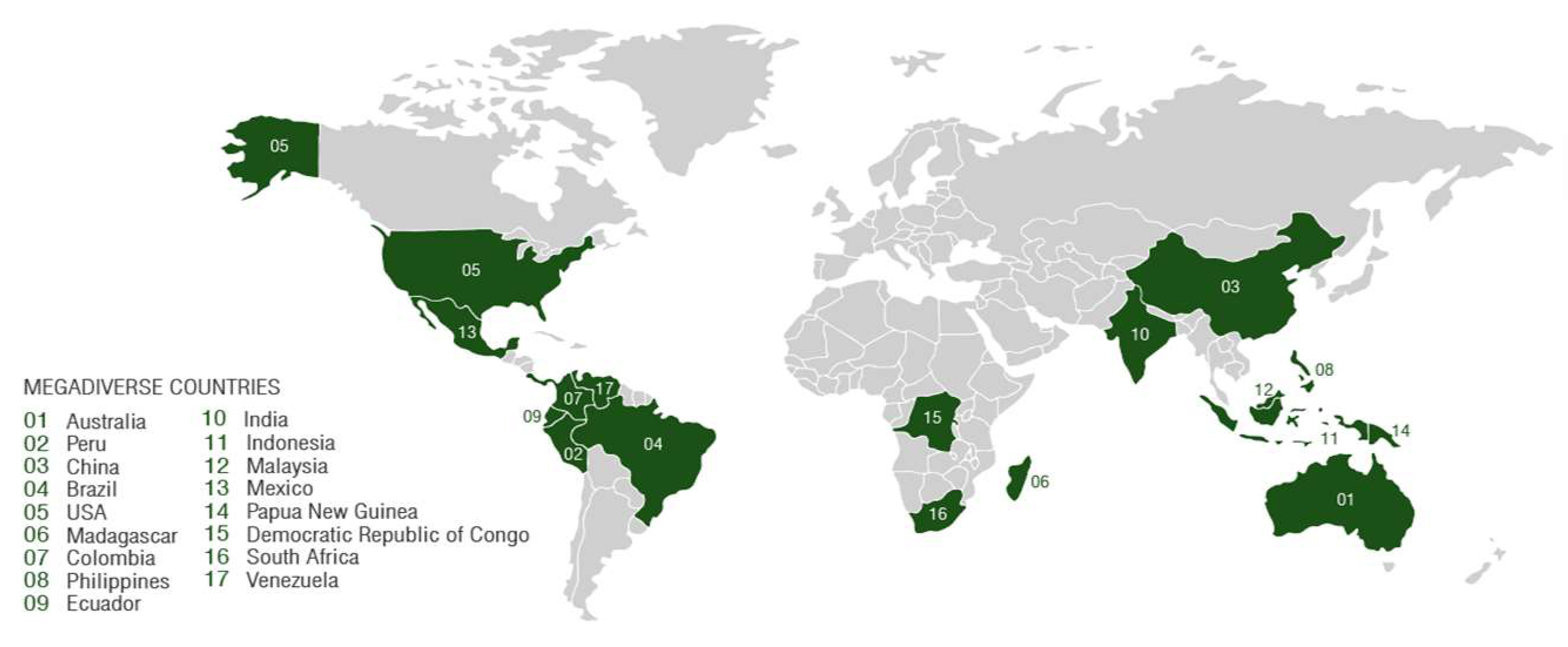
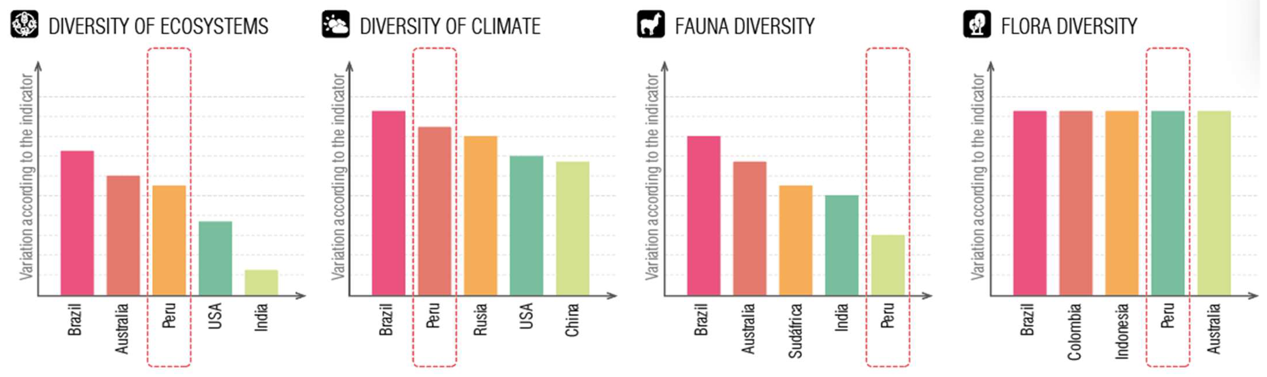
Biodiversity conservation is important to ensure sustainability and human well-being, as it represents the relationship between living beings and the natural environment they inhabit [1]. Currently, on a global scale, 17 megadiverse countries have been classified. Despite occupying only 10% of the total surface area of the planet, they also host 70% of the biodiversity [2]. The ranking of these countries is directly related to the amount of endemic plant and animal species, as well as the climates and ecosystems present (Figure 1).
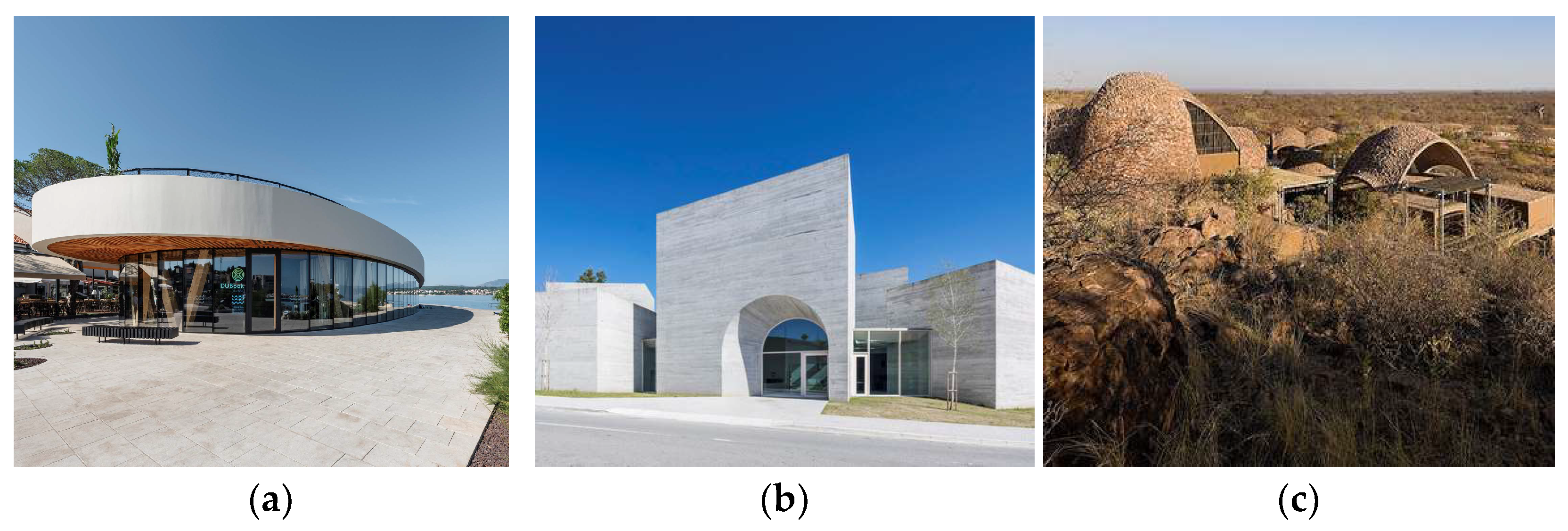
In addition to the environmental significance that biodiversity holds, it also represents the identity of a place through its flora, fauna, climatic variety, topography, and more [3]. Therefore, it is necessary to preserve and disseminate the role that biodiversity plays in the world. Interpretation centers, with the spaces they possess, allow for an impact on individuals regarding the location they are situated in. Likewise, they enable social integration and a closer connection to nature [4]. The primary strategy used to generate a positive effect within the community at the Maritime Heritage Interpretation Center in DUBoak is to promote fishing activity by engaging citizens in productive activities and by highlighting the regional and national importance of marine products [5]. Another approach to community integration is demonstrated by the Romanesque Interpretation Center, creating a new reference point for the population that strengthens the bond between the place and its people [6]. One of the strategies employed to foster a connection with nature is exemplified by the Mapungubwe Interpretation Center. This center stands out for its use of local materials and communal spaces, thus actively involving residents in promoting the significance of these local materials and their diverse functions. (Figure 2).
Similarly, interpretation centers should be developed within an environment that aligns with the same approach as this structure, such as Gran Colombiano Park. This park employed key design strategies to promote accessibility to heritage, reconnect natural and urban systems, engage with the community, and revive vernacular construction traditions. These strategies foster social integration and the development of the population in harmony with nature. Furthermore, they preserve endemic flora and fauna by integrating low-impact public spaces that harmonize with the surroundings, achieved through the use of traditional construction materials and techniques. The park also includes areas dedicated to conserving flora and fauna, especially endemic birds that thrive in the microclimate created by the inclusion of wooded areas within the park.
In the context of global biodiversity, Peru occupies the position of the second most megadiverse nation, marked by the allocation of 17.3% of its national territory to protected natural areas. Within its administrative regions, Cusco emerges as a notable entity due to its role as a reservoir for an extensive array of endemic flora and fauna. Moreover, Cusco showcases a diverse spectrum of microclimates and ecological zones [10]. This assortment of microclimates arises from the variances in altitude characteristic of the Peruvian Andes. Consequently, these altitudinal gradients have given rise to distinct ecological zones, each tailored to specific climatic prerequisites, thereby configuring diverse cultivation systems to accommodate the thriving of individual plant species (Figure 3).
At present, Cusco stands out as the city experiencing the most pronounced influx of visitors, encompassing both domestic and international travelers, contributing to 6.3% of the total national-level journeys [11]. The predominant factor behind Cusco’s substantial appeal lies in the enduring legacy of the Inca civilization. The Inca Empire distinguished itself through its well-defined economic, political, and social structure, positioning it as a prominent and unparalleled entity within the South American context. Within this domain, the Inca achieved a remarkable degree of acclaim for their contributions to scientific, technological, architectural, urban planning, and organizational progressions, which continue to reverberate throughout contemporary society.
Furthermore, the Incas upheld a complex rapport with the universe and the realm of spirituality. Their conviction in the significance of each living entity as an integral component of the community, spanning from the smallest plant to the grandest animal, as well as their spiritual affiliation with celestial bodies such as the sun, moon, and stars, constituted the foundational essence of their society. This comprehensive outlook is denoted as the “Andean cosmovision” [12].
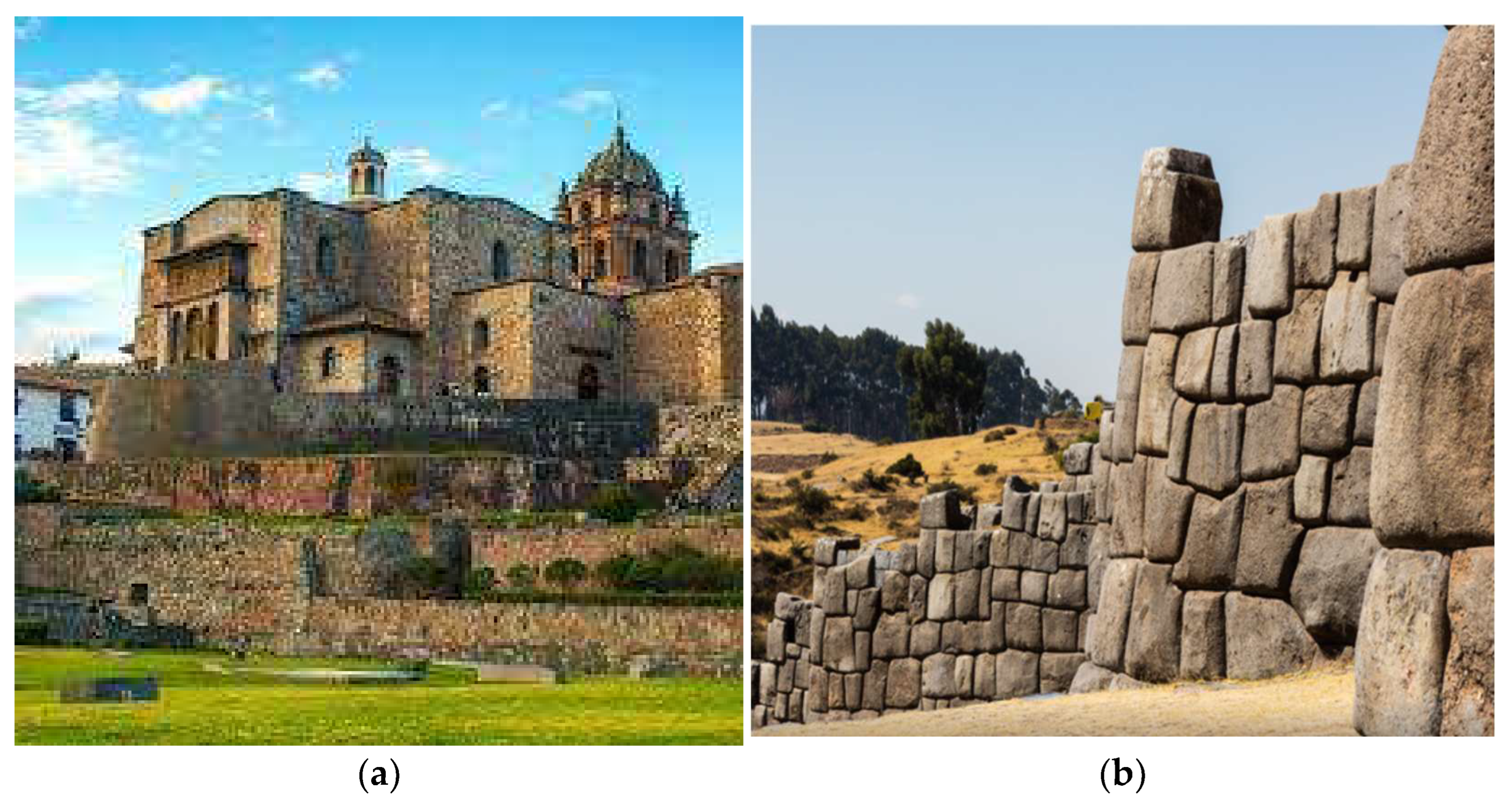
Another salient facet pertained to the Incan architectural undertakings, recognized as “huacas”, some of which are presently under active investigation, including sites like “Coricancha” or “Sacsayhuaman” (Figure 4). This dimension of Peru’s historical narrative occupies a substantial niche within our collective identity and cultural heritage [13].
Nevertheless, despite the substantial quantity of archaeological sites within the Cusco region and their inherent significance, a subset of these sites languishes in a state of inadequate preservation and remains relatively underexplored by tourists. This divergence primarily stems from their geographic placement, distant from the central cluster of tourist focal points situated within Cusco’s historic center. The most prominently visited destination remains Machu Picchu, accounting for a 25% influx of foreign tourists in the year 2022 [16]. Illustrative of this phenomenon is “Markavalle”, positioned in close proximity to the Alejandro Velasco Astete International Airport, yet beset by a state of deterioration [17].
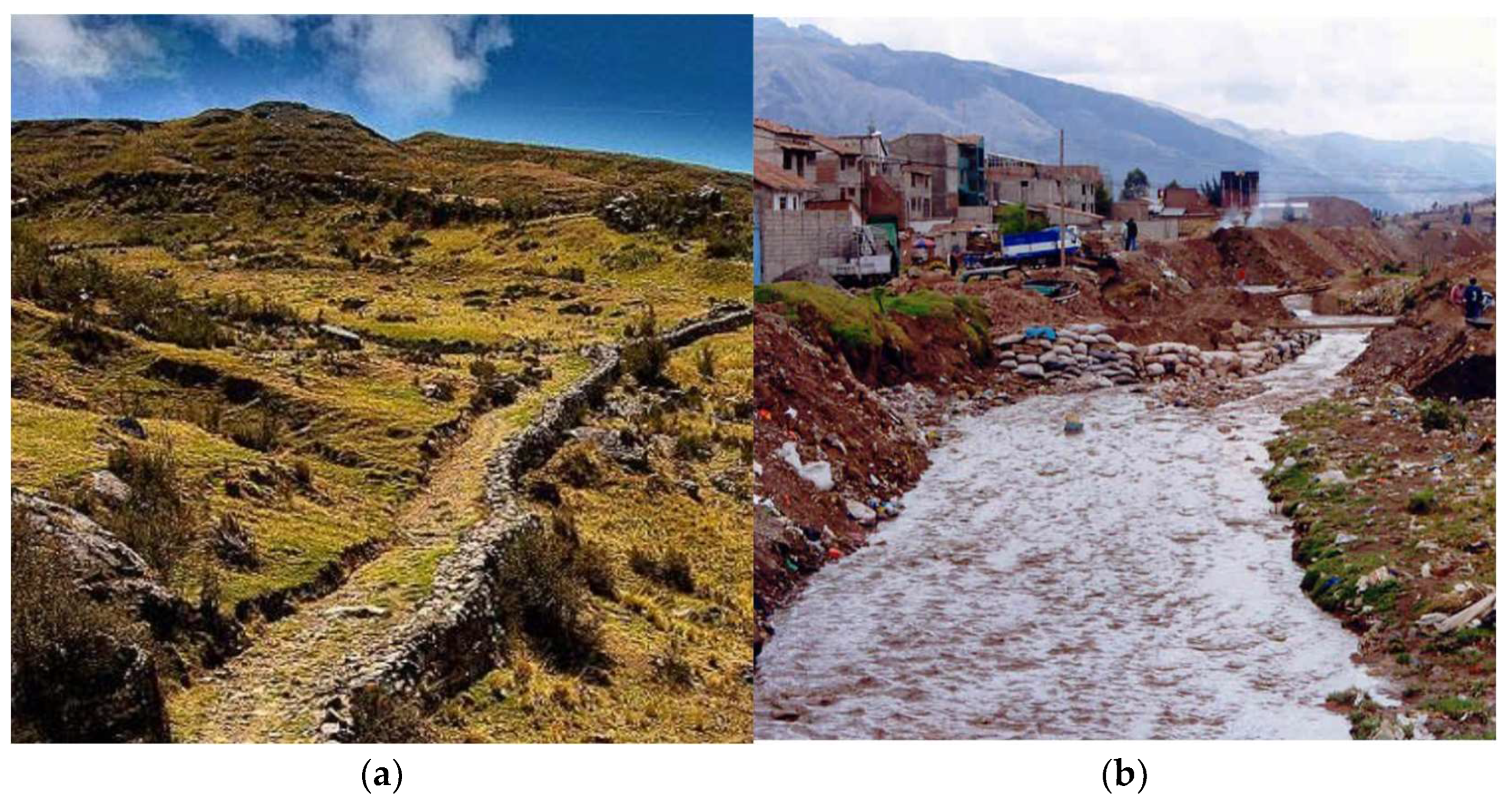
Additional critical components affected by contamination arising from solid waste disposal encompass “Qhapaq Ñan” route and the Huatanay River [18] (Figure 5). Both these entities hold substantial significance, spanning the local district and provincial tiers. The Qhapaq Ñan is continually subject to study as a mechanism of interconnection and communication among communities, while the Huatanay River serves as the paramount water source for the entirety of the Cusco valley [19].
In the context of Cusco’s challenges, the environmental realm highlights an ongoing imbalance between deforestation and reforestation. Merely 9.3% of the appropriate reforestation zones have been addressed [22]. Moreover, environmental disturbances stemming from meteorological occurrences such as hailstorms, frosts, snowfalls, heavy rainfall, cold spells, floods, droughts, lightning storms, strong winds, mudslides, and erosion further compound the situation [23]. In terms of productivity, fish farming and livestock, including wool production, play a significant role. However, these resources remain underutilized as potential income generators within their respective regions [24]. Biologically, the struggle revolves around endangered endemic species due to habitat degradation caused by deforestation, water contamination, and the introduction of non-native species. This results in the erosion of ecosystems. Furthermore, a study of micro-watersheds revealed 11 plant species within the conservation spectrum, ranging from critically endangered to nearly threatened [25].
Within the social sphere, a notable surge in crime and violence prevails. The deterioration extends to educational and healthcare facilities. Despite the existence of tuition-free schools, both infrastructure and furnishings are subpar. Similarly, the healthcare sector grapples with a dearth of health centers to accommodate present needs [26]. Among the foremost challenges facing Cusco, the perpetual jeopardy to local flora and fauna stands out due to the indiscriminate utilization of endemic plants and the illicit hunting of select animal species. This results in the erosion of ecosystems, agricultural lands, and territorial integrity [27].
Hence, the current research endeavors to propose an architectural blueprint for an Interpretation Center aimed at elevating the significance of Cusco’s flora and fauna in Peru in 2023.
2. Methods
2.1. Methodological Scheme
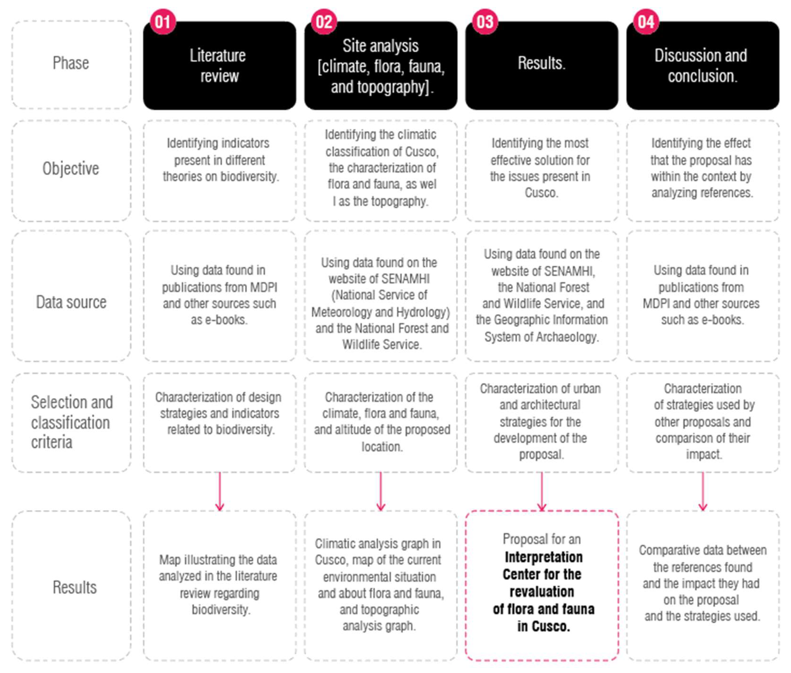
Figure 6 outlines the stages and process of the research, commencing with the review of information according to data sources, followed by characterization based on the presented subtopics, and the development of strategies to achieve an appropriate proposal aligned with the context at hand. In phase 2 for the development of the data and climate analysis, a database is used that is SENMAHI, which is the National Meteorology and Hydrology Service of Peru, it is a public body attached to the Ministry of the Environment whose objective is to generate information and meteorological, hydrological and climatic knowledge, in an accessible and truthful way for the benefit of the Peruvian population, operates with a national network of more than 900 meteorological and hydrological stations in accordance with technical standards of the World Meteorological Organization (WMO).
The present research is of a non-experimental nature, beginning with the compilation of information from scientific articles, followed by the identification of data aligned with the topic and its proper classification. Finally, the correct design strategies are implemented to create a proposal that fulfills the desired objective [28].
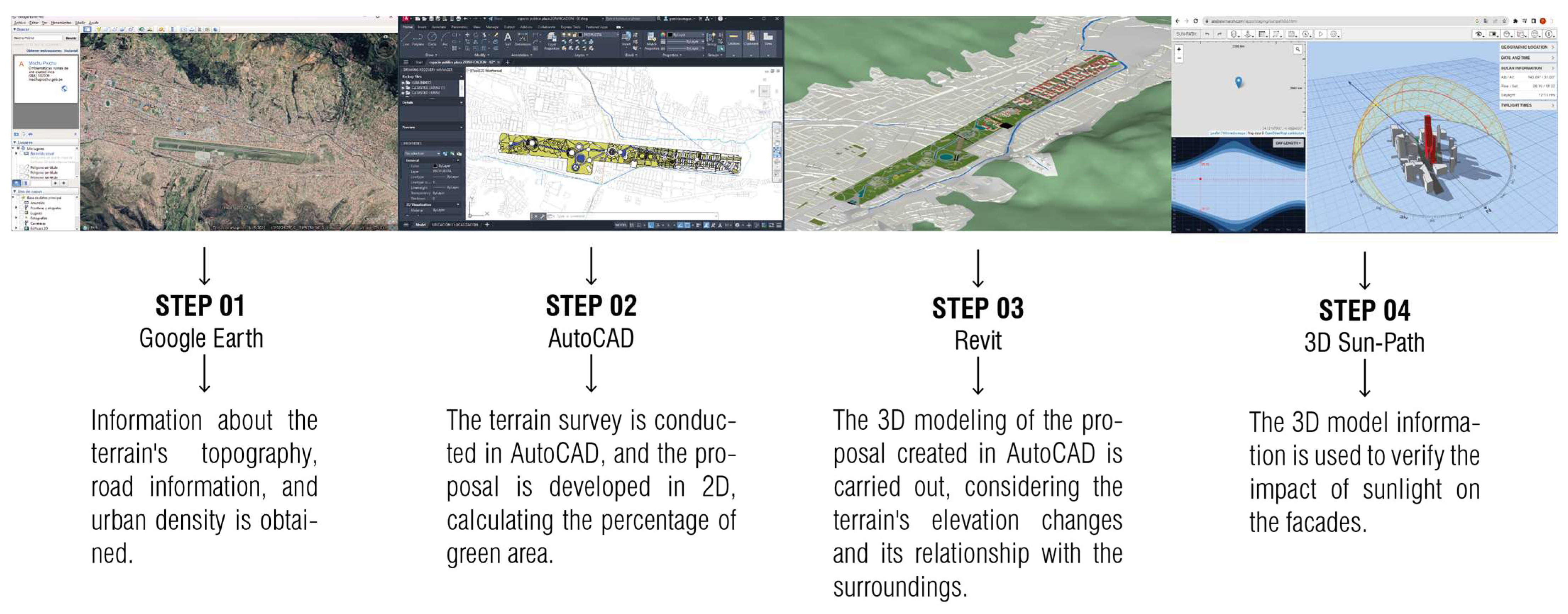
In Figure 7, the procedural steps essential for executing the proposal are delineated. The fundamental objective of this proposal is to establish spaces that actively foster the conservation of endemic species within the Cusco department. The initial step (Step 1) encompasses the acquisition of terrain data through Google Earth, providing crucial information pertaining to elevations and cross-sections of primary roadways. Transitioning to Step 2, an in-depth terrain survey is conducted using AutoCAD 2022, resulting in the delineation of road networks and axes. Notably, this phase also involves the conceptualization of an urban proposition in alignment with the fundamental tenets of the “Inca cosmovision”. Advancing to Step 3, subsequent to the conceptualization in AutoCAD, a sophisticated 3D model of the sanctuary and the interpretation center is actualized using Revit 2022. Finally, in Step 4, a comprehensive 3D Sun-Path 2023 analysis is executed to ascertain the solar influence on the facades and the efficacy of solar protection within the communal spaces intrinsic to the proposal.
2.2. Study Area
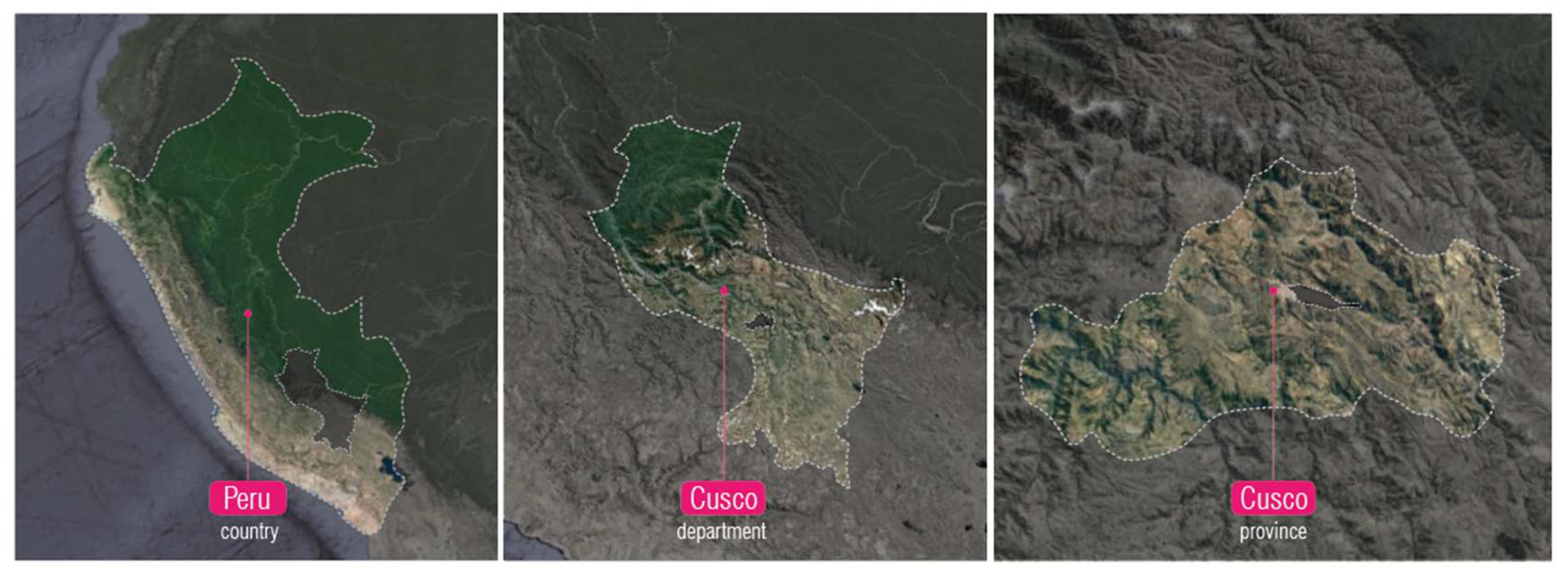
The province of Cusco is part of one of the 13 provinces that make up the Cusco department, located in southern Peru (Figure 8). It borders Calca and Urubamba to the north, Paruro to the south, Anta to the east, and Quispicanchi to the west. Additionally, the Huatanay River is the main river in the Cusco department, forming its sub-basin in the Vilcanota River. It is fed by the Saphy and Tullumayo rivers, which cross the historic center. Latitude: −13.538766, Longitude: −71.943876.
2.3. Climatic Analysis
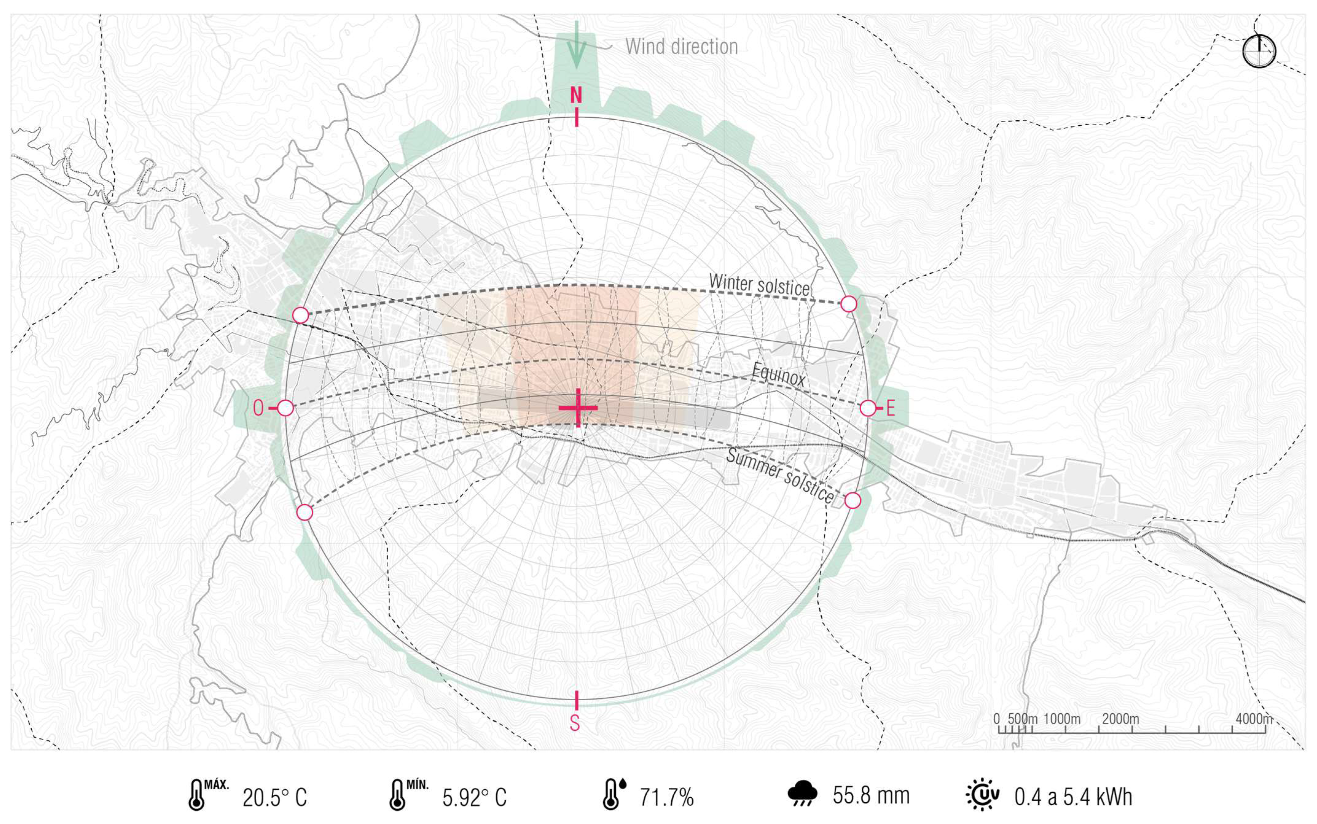
In Figure 9, the analysis of Cusco’s solar chart is presented, delineating the specific periods within the year characterized by heightened solar exposure on building facades.
The climate in Cusco plays a pivotal role in shaping the region’s botanical and zoological composition. Nestled within the Andean landscape, Cusco experiences a distinct mountainous climate distinguished by notable seasonal fluctuations. The region’s rugged terrain and varying elevations further generate an assortment of microclimates, which in turn create a spectrum of habitats conducive to the adaptation and diversification of a myriad of plant and animal species.
Cusco exhibits a temperate climate characterized by dry winters and mild summers. The average annual maximum temperature peaks at 22 °C from July to November, while the coldest months of June to August witness temperatures dropping to as low as −1 °C. These temperature gradients provide a suitable milieu for the growth of indigenous plant species like orchids, puyas, queñuales, as well as fostering habitats for fauna such as the Andean cock-of-the-rock and the Andean condor.
From January to April, humidity reaches its zenith at around 79%, tapering to an average of 66% between July and September. Rainfall patterns follow a more consistent rhythm from December to March, with January experiencing the highest levels at 143 mm. In contrast, precipitation diminishes significantly during the months of June to August, registering around 4 mm. This dynamic interplay between wet and dry seasons propels plant adaptations to fluctuating environmental conditions. Plants have evolved survival mechanisms, including drought-resistant features like cacti, agaves, quinoa, and yareta. Additionally, these species have synchronized their flowering cycles with the appropriate seasons to ensure reproductive success and enduring survival.
Prevailing winds predominantly emanate from the north, with variations spanning from NE to NW, and an average speed of 9.8 km/h. Solar radiation remains relatively constant throughout the year, averaging between 0.4 and 5.4 kW-h. Both solar radiation and wind velocity exhibit limited fluctuations, a factor instrumental in shaping the design of the Interpretation Center. This architectural layout harnesses the augmented solar exposure on the northern façade during the months from March to September, facilitating the incorporation of eaves and design strategies that maintain optimal interior thermal conditions. This design philosophy not only enhances visitor comfort but also instills an awareness of the local climate conditions.
In essence, Cusco’s climatic diversity, defined by its assorted microclimates and elevation gradients, significantly contributes to the proliferation and safeguarding of a diverse range of flora and fauna. This distinctive ecological setting presents avenues for conservation efforts, scientific exploration, and sustainable tourism, thereby underscoring the urgency of protecting these invaluable ecosystems.
2.4. Environmental, Flora, and Fauna Analysis
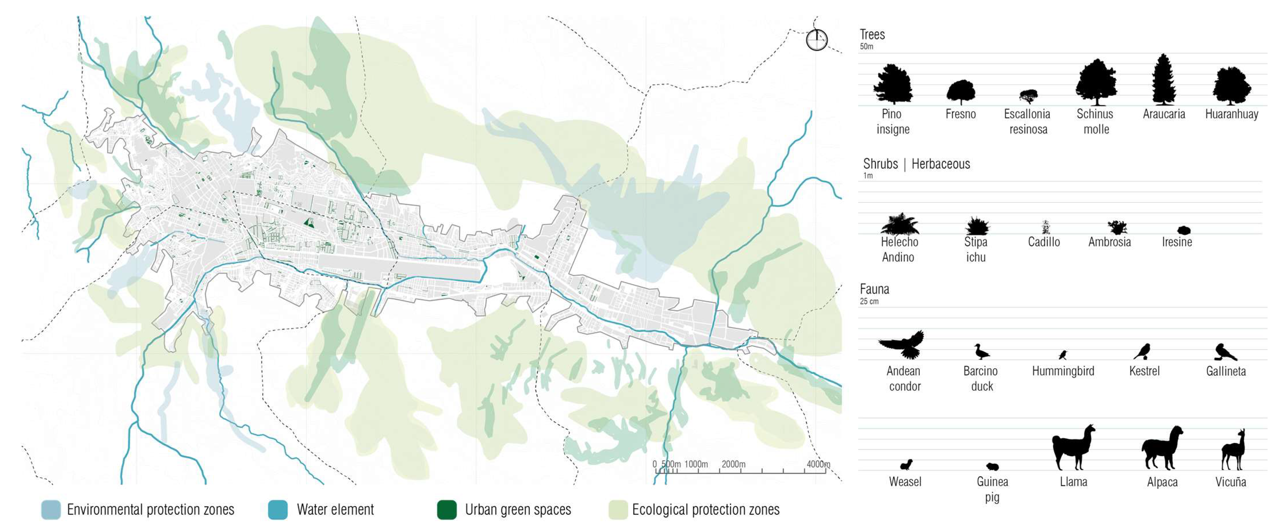
In the district of Wanchaq, the classification of areas differs between the urban area and the external area. The urban area is classified as “areas with human activity” and has low biological diversity. However, the external area, outside the district, is classified as “high and medium biological diversity wet puna grasslands”, indicating a significant presence of diverse ecosystems. Therefore, this sector is considered a zone of ecological and environmental protection according to the provincial development plan [29].
Figure 10 illustrates the distribution of urban public spaces across different regions within the province, with a prevailing presence of sports fields and residual areas. The visual representation also highlights the abundance of water elements, yet a concerning fact emerges: 72% of these water features are contaminated. Notably, substantial portions of the territory are dedicated to environmental protection zones and ecological preservation zones, primarily concentrated within archaeological areas.
Within the realm of flora and fauna, a range of endemic plant and animal species exhibit a notable diversity. However, certain endemic flora is now endangered due to the infiltration of invasive species into their native habitats, compounded by deforestation activities. This issue is mirrored in the fauna domain where, despite a substantial representation of endemic species, the constant threat of poaching and the detrimental influence of human activities pose challenges to their continued development and survival.
3. Results
3.1. Location of the Urban Proposal
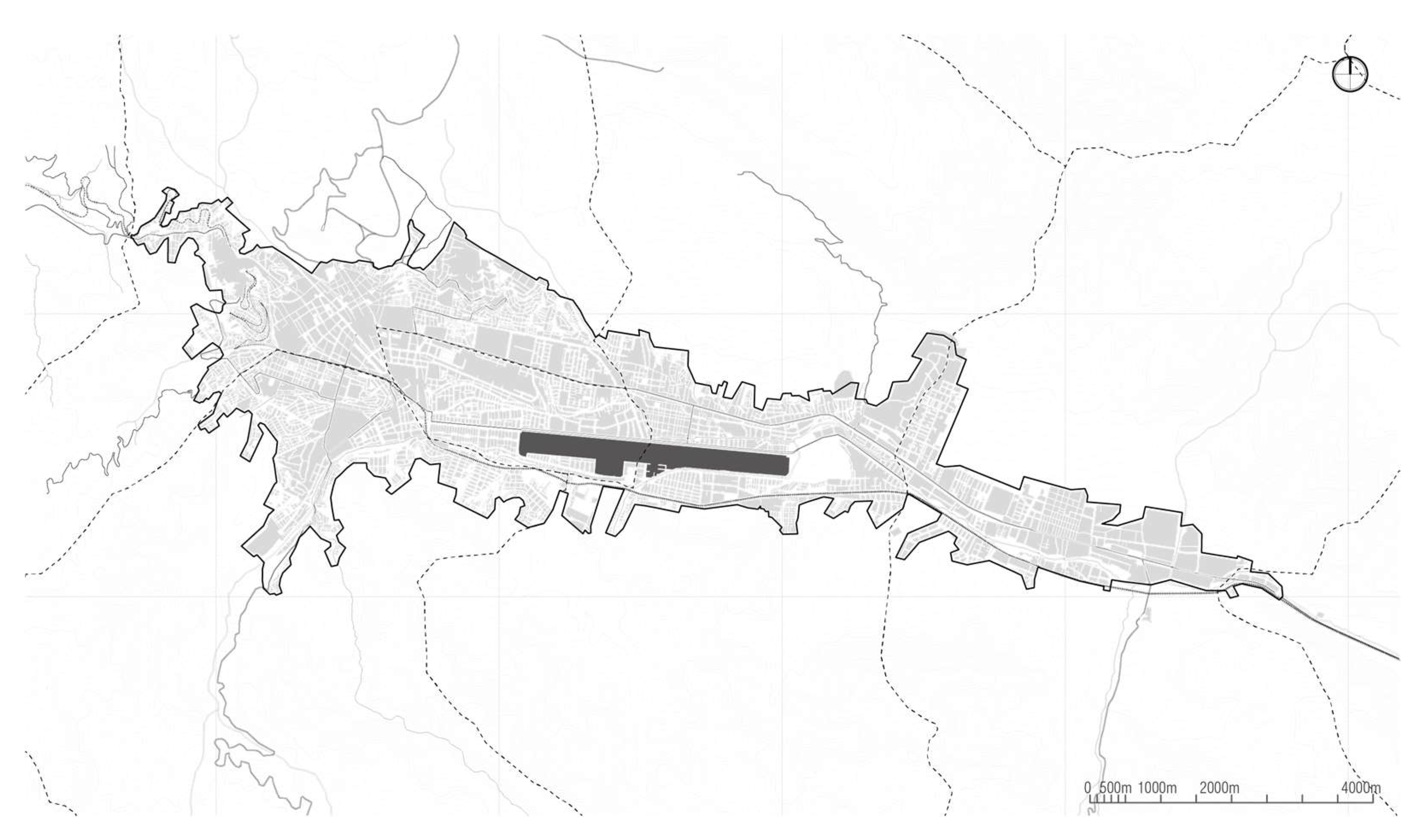
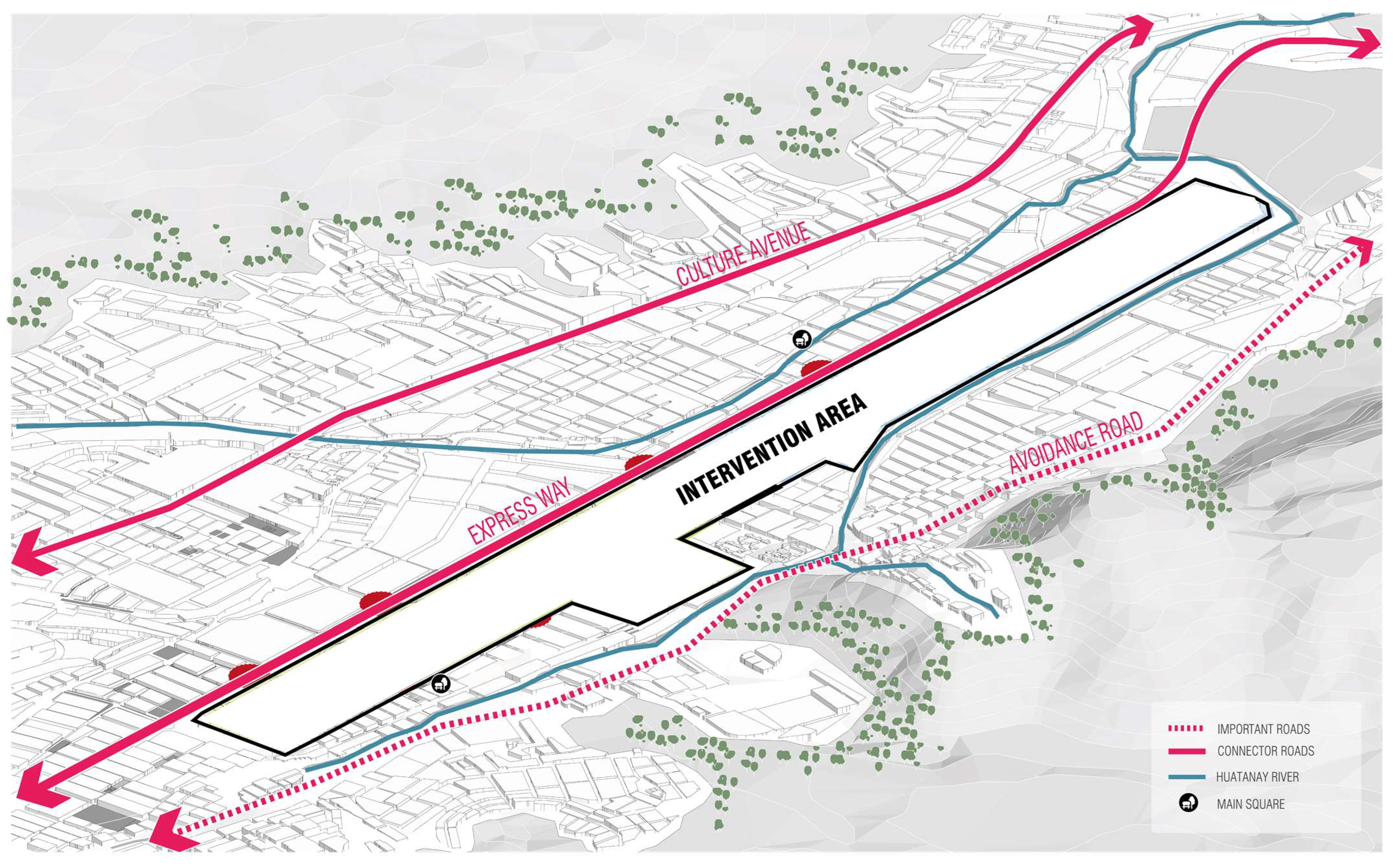
The urban proposal is located on the land currently occupied by the Alejandro Velasco Astete International Airport, in the district of Wanchaq, Cusco. The land has an approximate area of 128 hectares.
The Velazco Astete International Airport is the second most important air terminal in Peru, because of the millions of visits that the city of Cuzco receives annually, many of them for tourist purposes and coming from abroad. These millions of annual visits make the land on which the airport is located a tourist symbol of Cuzco, being the access gates to the city and the starting point for a journey full of history and adventure.
Its existence came into controversy when on 11 October 2001, a project was created for the construction of the Chinchero International Airport located in Urubamba (a decentralized province of Cusco) which would become the official airport of the region and would leave unused to Velasco Astete. This land where the still-operating Velasco Astete is located would not remain vacant, because it is planned that urban development within this area has public buildings, services, and above all green areas, which the city lacks; all with the aim of collaborating with the functioning of the city of Cuzco (Figure 11).
In this context, the land in question takes on great value, being a canvas of thousands of possibilities for the growth of the city. Although this is a positive scenario, one must take the responsibility that what is projected can empower endemic characteristics of Cuzco, or completely renew its image, or perhaps rediscover some concept lost in time.
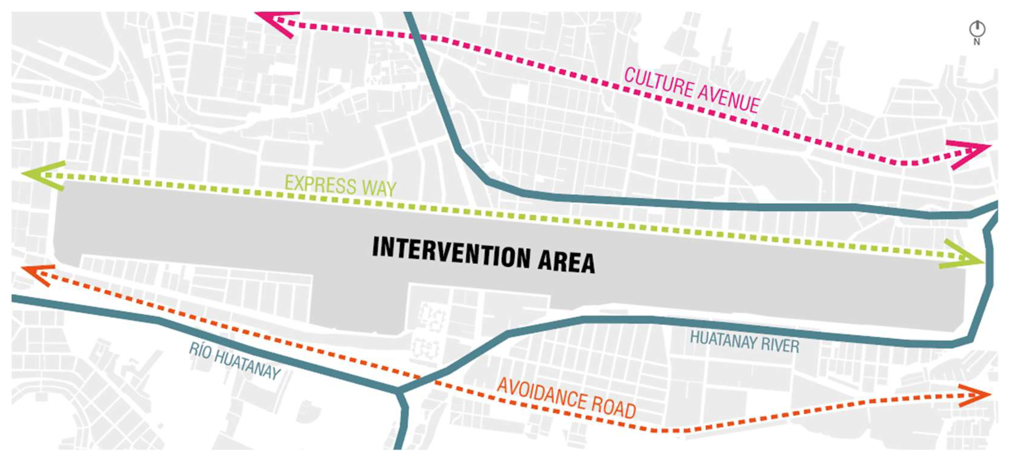
The city of Cusco presents an irregular morphology on its edges. The place of intervention is located at the Teniente Velasco Astete International Airport. Which is the main point of arrival for anyone who wants to know the Inca city (Figure 12). The intervention area (empty) of the project presents an area of 1,279,792.67 m2, equivalent to 127.979267 ha. The land is located 3000 m from the Plaza de Armas of Cusco and about 3000 m from Av. de la Cultura [30].
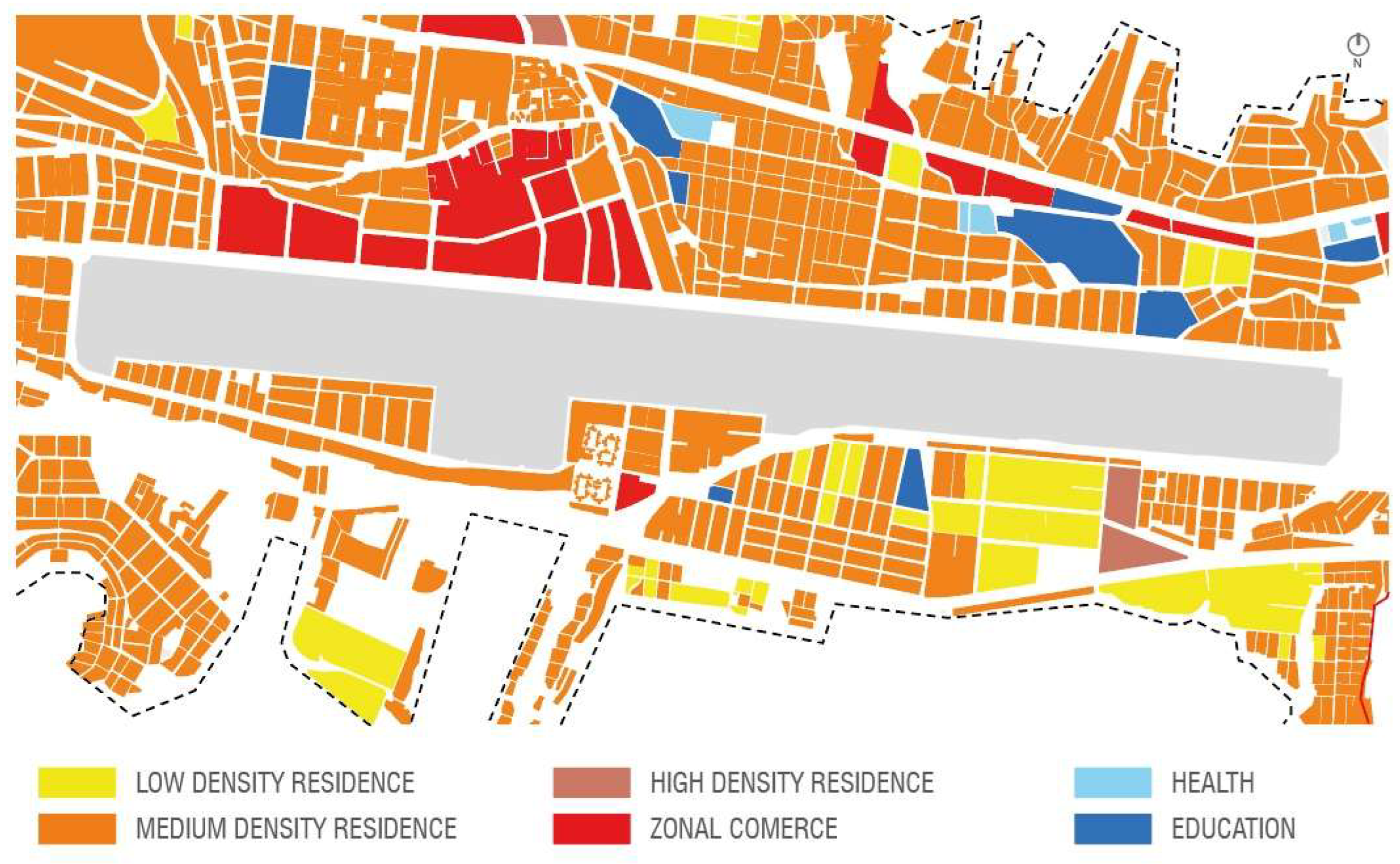
A large concentration of housing (medium-density residences and low-density residences) and a commercial area on top of the runway would allow us to understand of the notorious lack of a buffer zone (Figure 13).
Regarding flows traffic manages to stay within parameters that would classify it between fast or medium fast traffic, so this same issue is not postulated as a latent problem (Figure 14).
3.2. Conceptualization
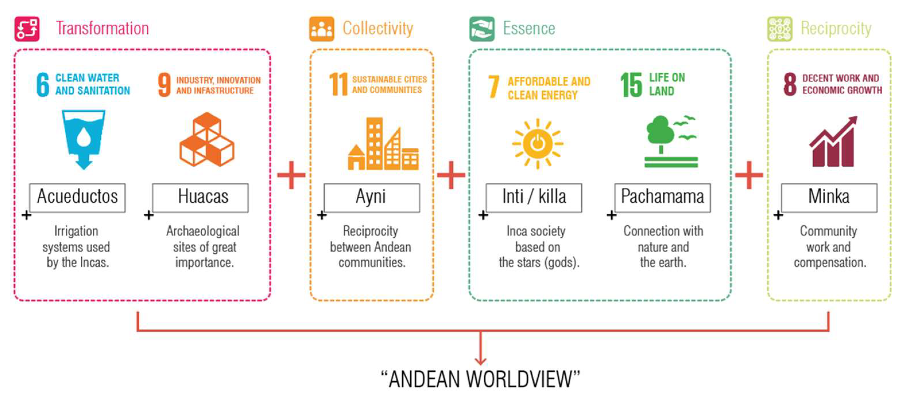
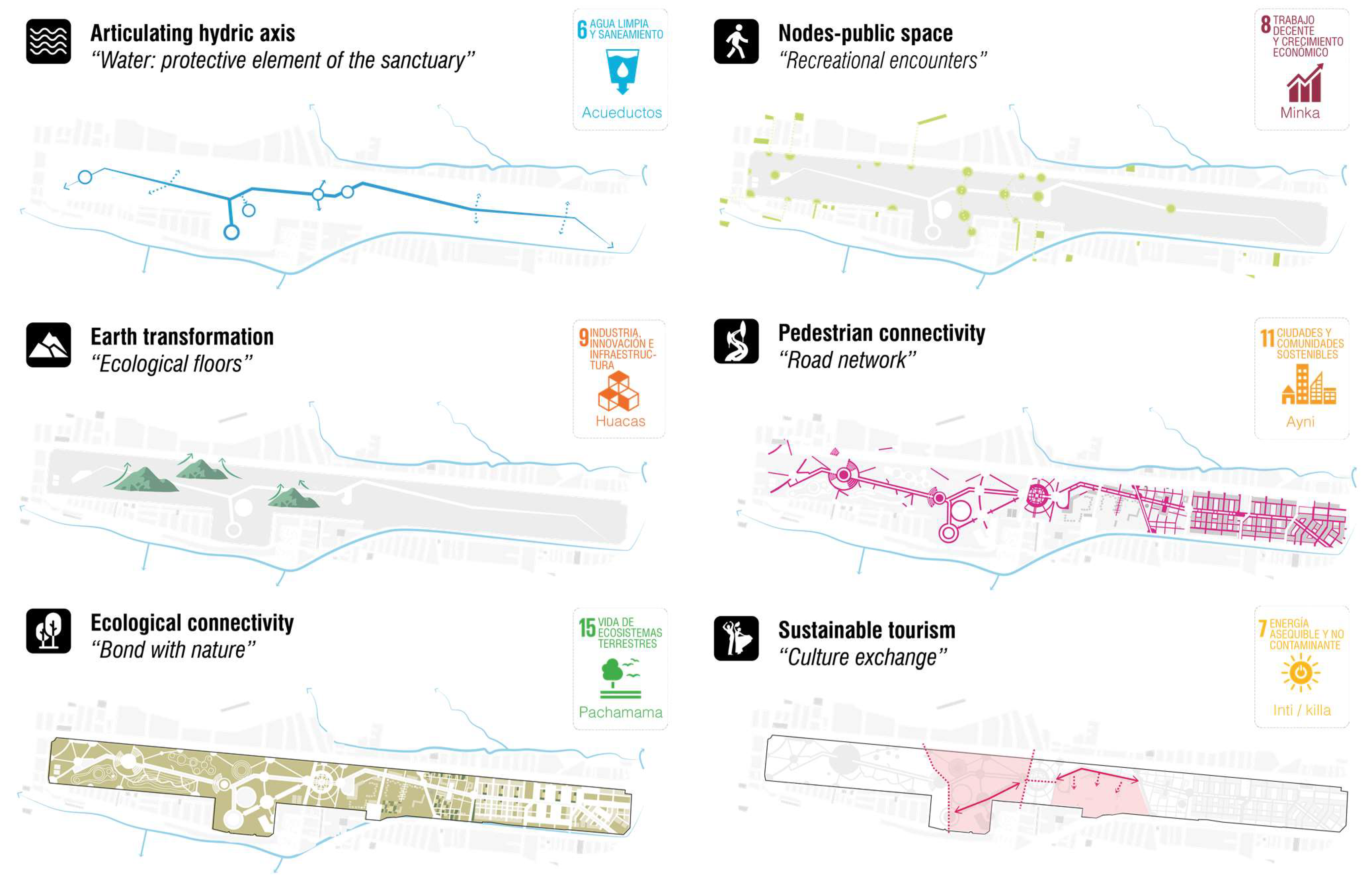
The concept used for the urban and architectural proposal is inspired by the organizational structure of the Inca Empire, as it is the reason for its significance in the world and its vision of the universe, known as the “Andean worldview”. The foundation of the Inca Empire is based on four principles: transformation, collectivity, essence, and reciprocity [31].
Furthermore, the relationship of these strategies with the Sustainable Development Goals (SDGs) was also considered, given their importance in creating a positive impact on the community. The concept used for the urban and architectural proposal is inspired by the organizational structure of the Inca Empire, as it is the reason for its significance in the world and its vision of the universe, known as the “Andean worldview”. The foundation of the Inca Empire is based on four principles: transformation, collectivity, essence, and reciprocity [32]. Furthermore, the relationship of these strategies with the Sustainable Development Goals (SDGs) was also considered, given their importance in creating a positive impact on the community (Figure 15).
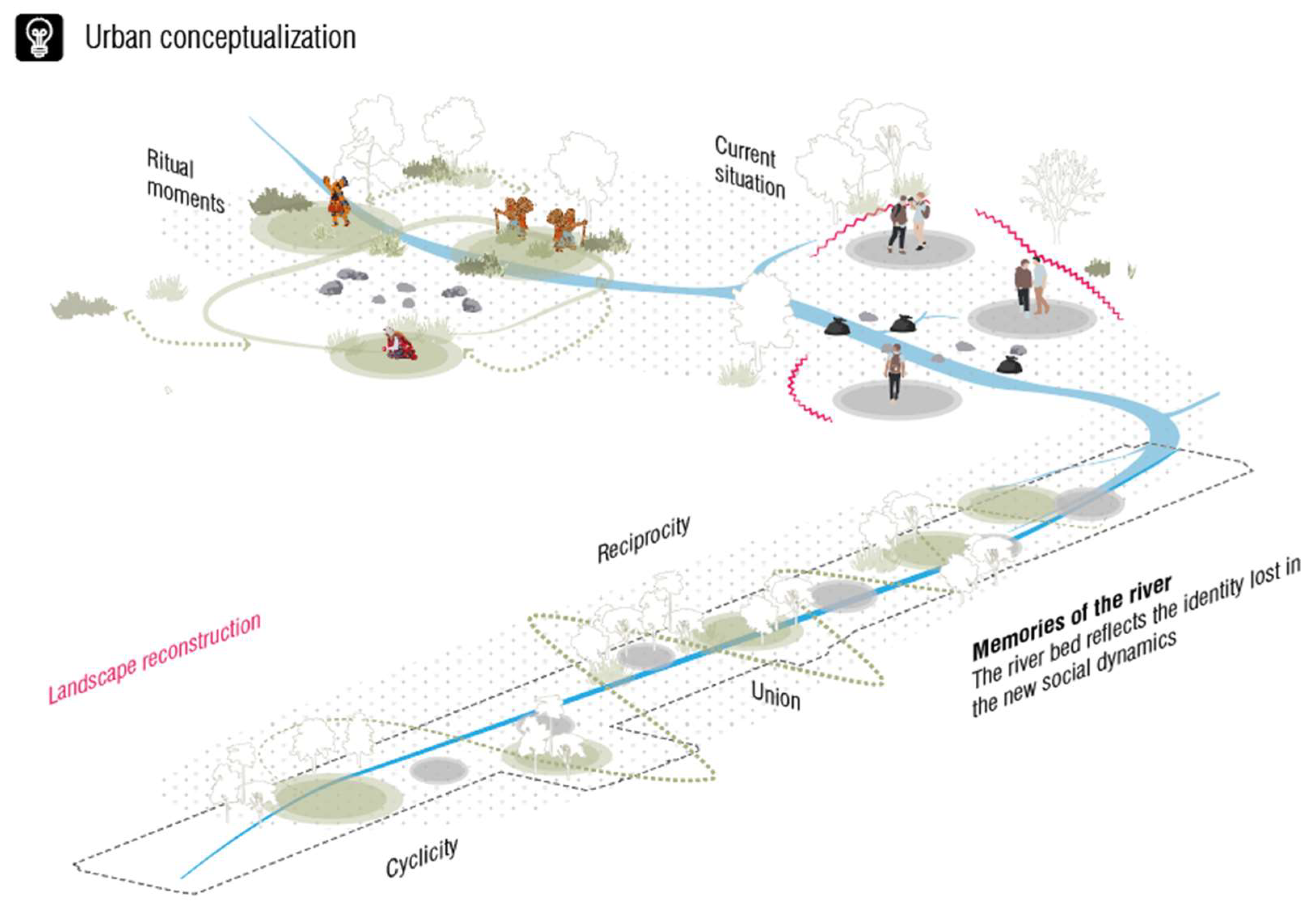
The urban concept based on the Inca cosmovision is grounded in the notion of community as ‘ayni’ and its relevance to the present society, which is focused on the urban proposal with its various public spaces (Figure 16).
Ayni, a core value, has been the foundation for generations of Andean peoples since pre-Incan times. It aided the Inca in accomplishing monumental projects such as an intricate water management system for their vast empire and diversified agriculture to sustain millions. Additionally, Ayni can be seen as the concept of reciprocity or mutualism among individuals in Andean communities or the practice of this concept. Indigenous communities are scattered throughout the Andes. In this rugged landscape, the ancient concept of Ayni (reciprocity) remains highly relevant. Communities collaborate in solidarity for the common good [33].
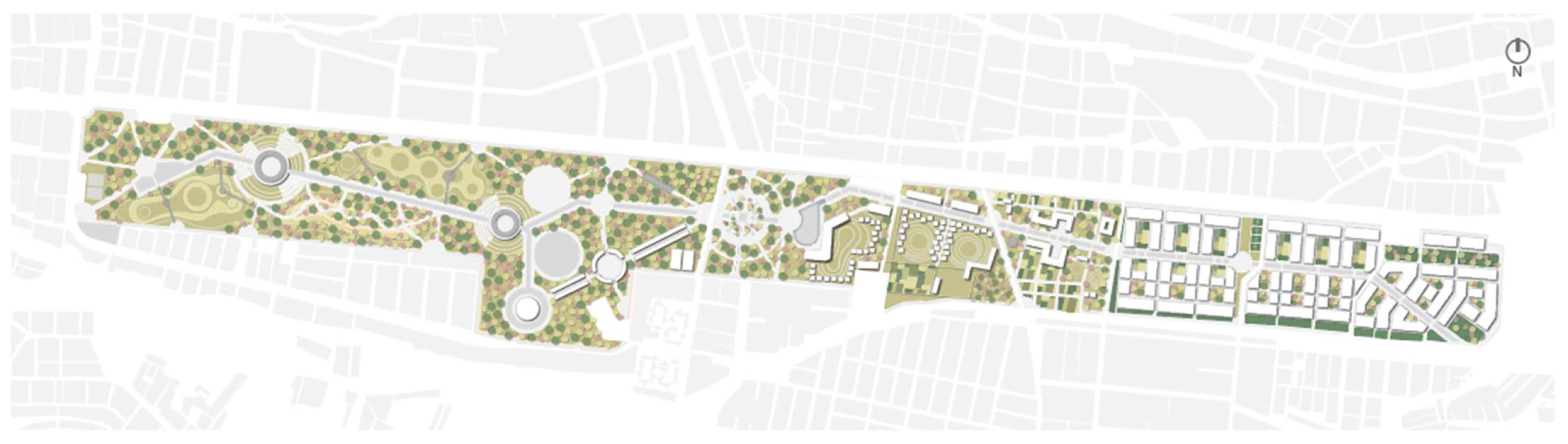
3.3. Master Plan
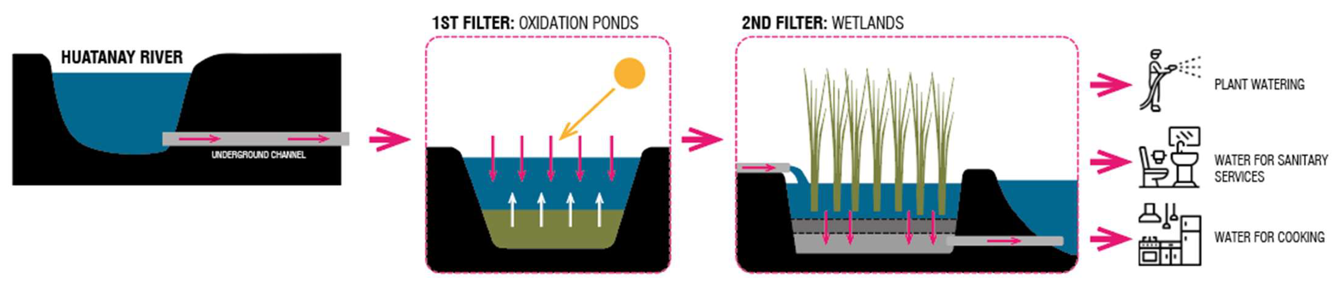
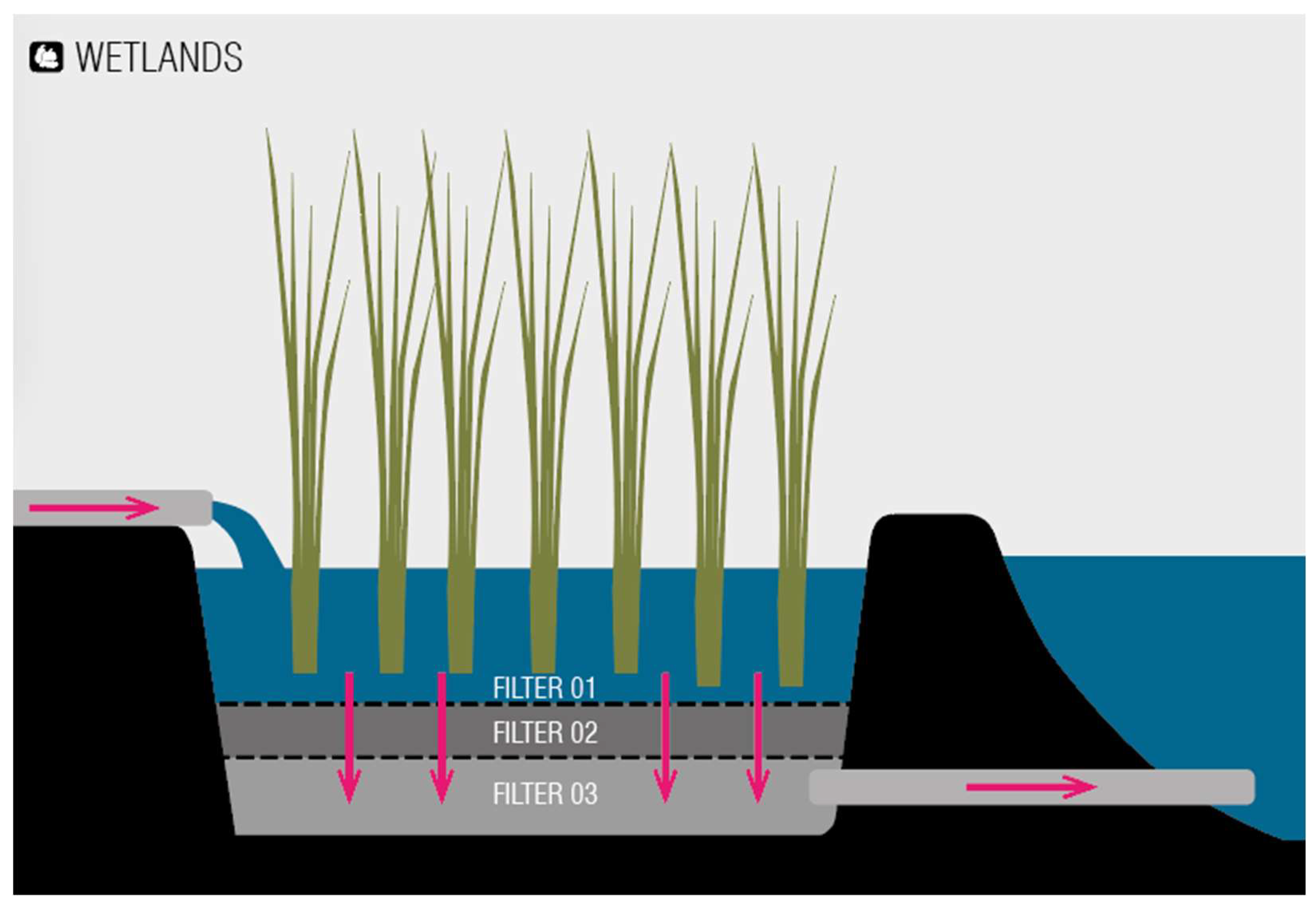
In Figure 17, the water filters of the Huatanay River are shown. In the first phase, an underground canal is proposed, originating from the Huatanay River and channeled towards the project site. The water from the canal passes through oxidation ponds, which are responsible for removing waste, oils, sands, and various sedimentable solids, as well as compounds like nitrates, ammonia, and phosphates, among others.
During Phase 1, 35% of the water is filtered. Subsequently, in Phase 2, the canal passes through artificial wetlands consisting of a bed filled with gravel and sand placed on an impermeable surface (clay) and macrophytic aquatic plants. In this phase, 80% of the water is filtered. Finally, during Phase 3, it undergoes a more extensive filtration process, which will have a final disposition for use in irrigating the preserved species. This system results in a reuse of 0.2 cubic meters of wastewater daily, reducing the pollution impact on the Huatanay River, as it receives a significant amount. The implementation of this wastewater treatment system will lead to pollution reduction.
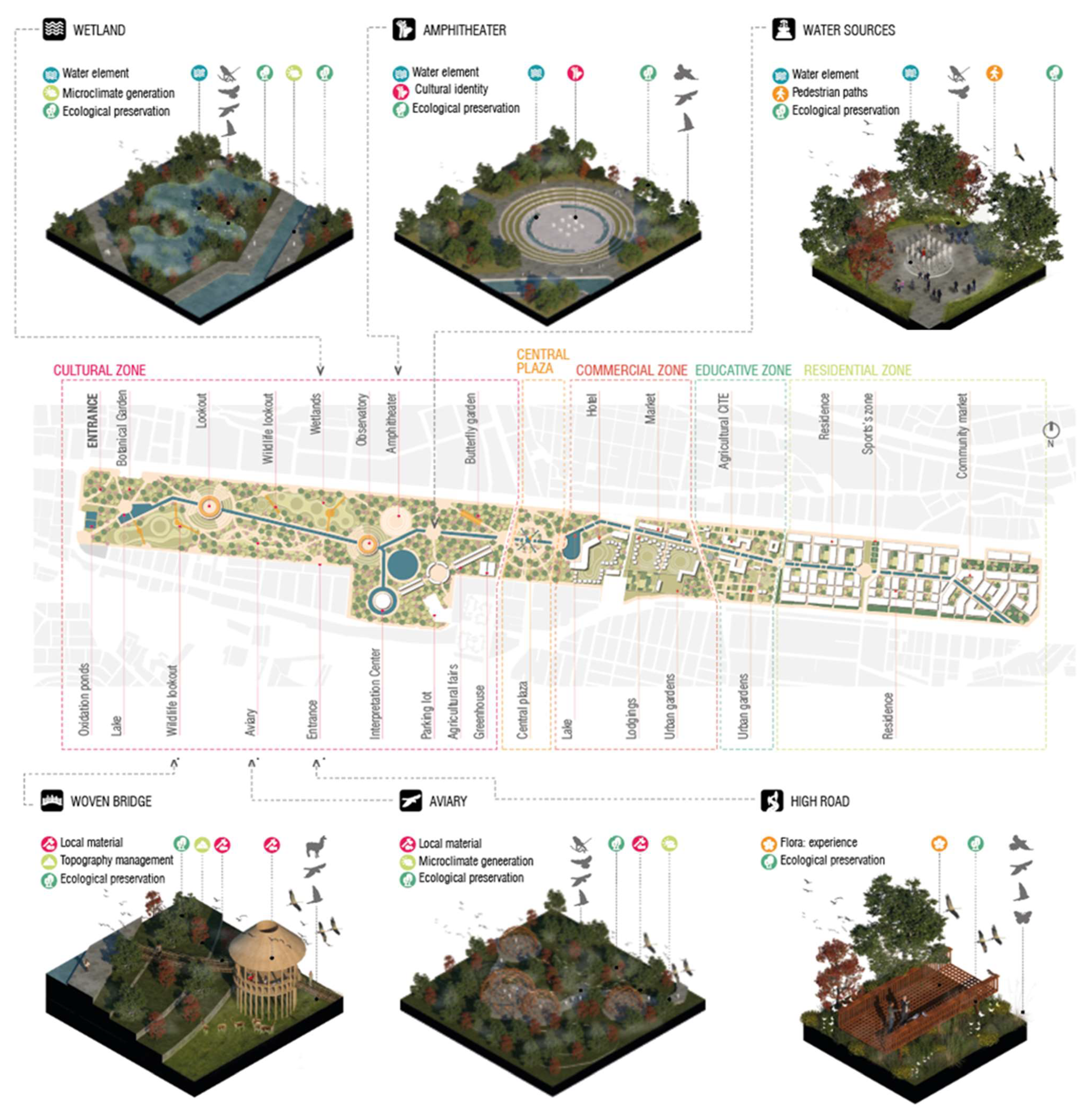
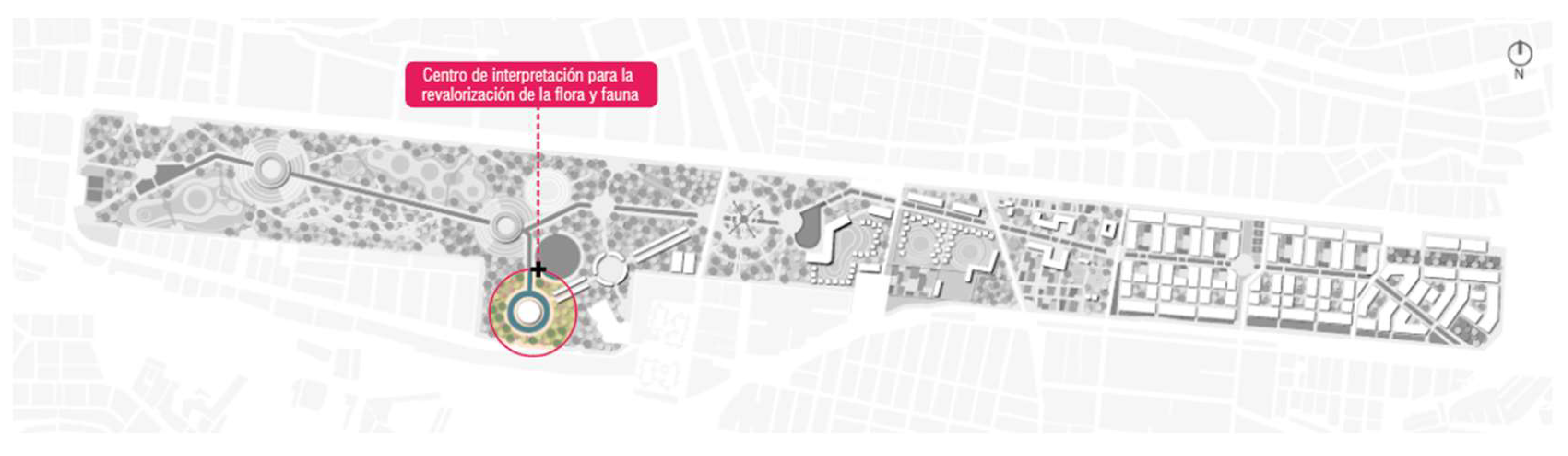
Based on the site analysis, a proposal is put forth comprising five distinct zones: a residential zone accommodating housing for 2000 residents and featuring amenities like sports facilities, urban gardens, and a community market to offer essential services in proximity; an educational zone housing a Center for Technology Transfer and Productive Innovation (CITE) with the objective of showcasing enduring Incan agricultural techniques; a commercial zone that includes an architecturally integrated hotel using local materials to blend with the natural landscape; a central plaza designed to connect both extremities while serving as an entry point to the ultimate cultural zone; this cultural zone operates as a sanctuary preserving the collective memory of the river and the surrounding scenery.
Within the realm of public spaces, wetlands play a pivotal role, particularly considering that constructed wetlands offer a multitude of benefits to both the environmental setting and the community. Ranging from water purification and flood control to the establishment of habitats and ecosystems, these deliberately designed ecological systems provide an array of ecosystem services while also presenting recreational and educational opportunities. The integration of constructed wetlands in both urban and rural contexts can substantially contribute to sustainable development and the overall well-being of both humans and nature [34]. Moreover, this integration fosters the preservation of aquatic fauna species such as Andean ducks, royal herons, and poroncoes, among others, as well as various flora species like ñihua, chillca, willows, poplars, molles, chachacomos, and cantus flowers, to name a few (Figure 18 and Figure 19).
The amphitheater holds significant value as a public space, offering an array of advantages for both individuals and communities. Its capacity to host large audiences, facilitate cultural events, support educational programs, and foster social unity makes it an integral component of urban and community planning. The distinctive design, historical importance, and connection with nature contribute to the amphitheater’s role as a vibrant and memorable gathering spot, enriching the cultural fabric of societies and enhancing overall quality of life [35]. The celebration of Inti Raymi, an ancient Inca festival honoring the sun, within a venue of this scale would provide an enriching cultural and festive experience.
Water fountains serve as dynamic public spaces that foster social integration and community participation. They offer opportunities for individuals to connect, interact, and share experiences, transcending social barriers and promoting a sense of belonging. By incorporating water fountains into urban design and planning, cities can create inclusive and vibrant public spaces that contribute to the well-being, cultural enrichment, and social cohesion of their communities [36].
The woven bridges found in Cusco, such as the Q’eswachaka Bridge, serve as a prominent illustration of the ancient wisdom and technical prowess exhibited by Andean cultures. The annual conservation and renewal of these structures underscore the significance of upholding cultural traditions and regional heritage. These bridges embody a remarkable heritage that encompasses expert craftsmanship, cultural importance, and environmental sustainability. They endure as symbols of collaborative community efforts, ancestral wisdom, and the profound interplay between human beings and their natural environment. Safeguarding and perpetuating this tradition not only enriches the cultural fabric and identity of the region but also evokes admiration and captivation among global visitors [37].
The aviary, as a point of identity and integration with the environment, plays a vital role in promoting ecological awareness, biodiversity conservation, and a sense of harmony between humans and the natural world. It serves as a source of education, inspiration, and pride, fostering a deeper understanding and appreciation for avian life and the importance of preserving their habitats. By creating a space where humans can connect with nature, an aviary becomes a powerful tool for promoting environmental management and ensuring a sustainable future for both birds and humans. The aviary features a dome-shaped structure fabricated of bamboo and wood, designed to facilitate birdwatching of species from the area such as doves, Andean coots, kestrels, tachuris, gallinules, plain-tailed wrens, among others. Aviaries not only provide a secure home for birds but also play a fundamental role in wildlife conservation by contributing to research, education, breeding, and the reintroduction of endangered species.
In Figure 20, it can be observed that the endangered avifauna in Cusco includes species such as the Andean condor (Vultur gryphus) and the Andean flamingo (Phoenicoparrus andinus). These birds face threats such as poaching, habitat loss, and pollution. Among the threatened birds in Cusco are the Torrent duck (Merganetta armata) and the Puna teal (Anas puna), which still have relatively stable populations but continue to face conservation challenges. The preserved birds in Cusco include species like the Ruddy duck (Oxyura ferruginea) and the Black-chested buzzard-eagle (Geranoaetus melanoleucus), which have been the focus of conservation efforts and have healthier populations due to protective measures and habitat management.
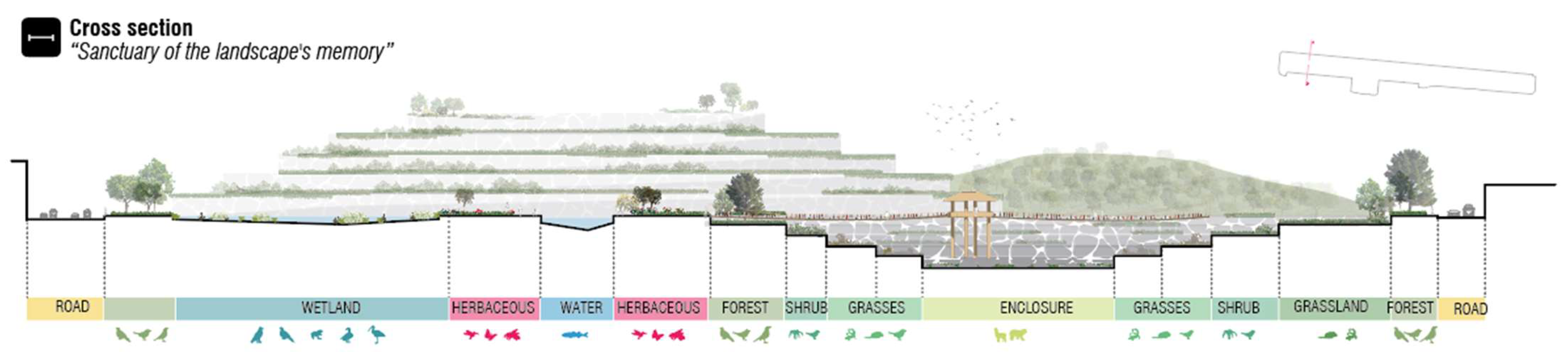
The elevated walkway, functioning as a public space, encompasses a spectrum of benefits for both individuals and the environment. It presents a distinct and immersive encounter, fostering a deeper affinity with nature and cultivating feelings of serenity and well-being. Additionally, the elevated walkway serves as a communal gathering spot, encouraging community engagement and providing avenues for educational enrichment. Ultimately, this pioneering notion of a public space not only exalts the elegance of the flora but also advances environmental consciousness and augments the reverence for the natural world (Figure 21).
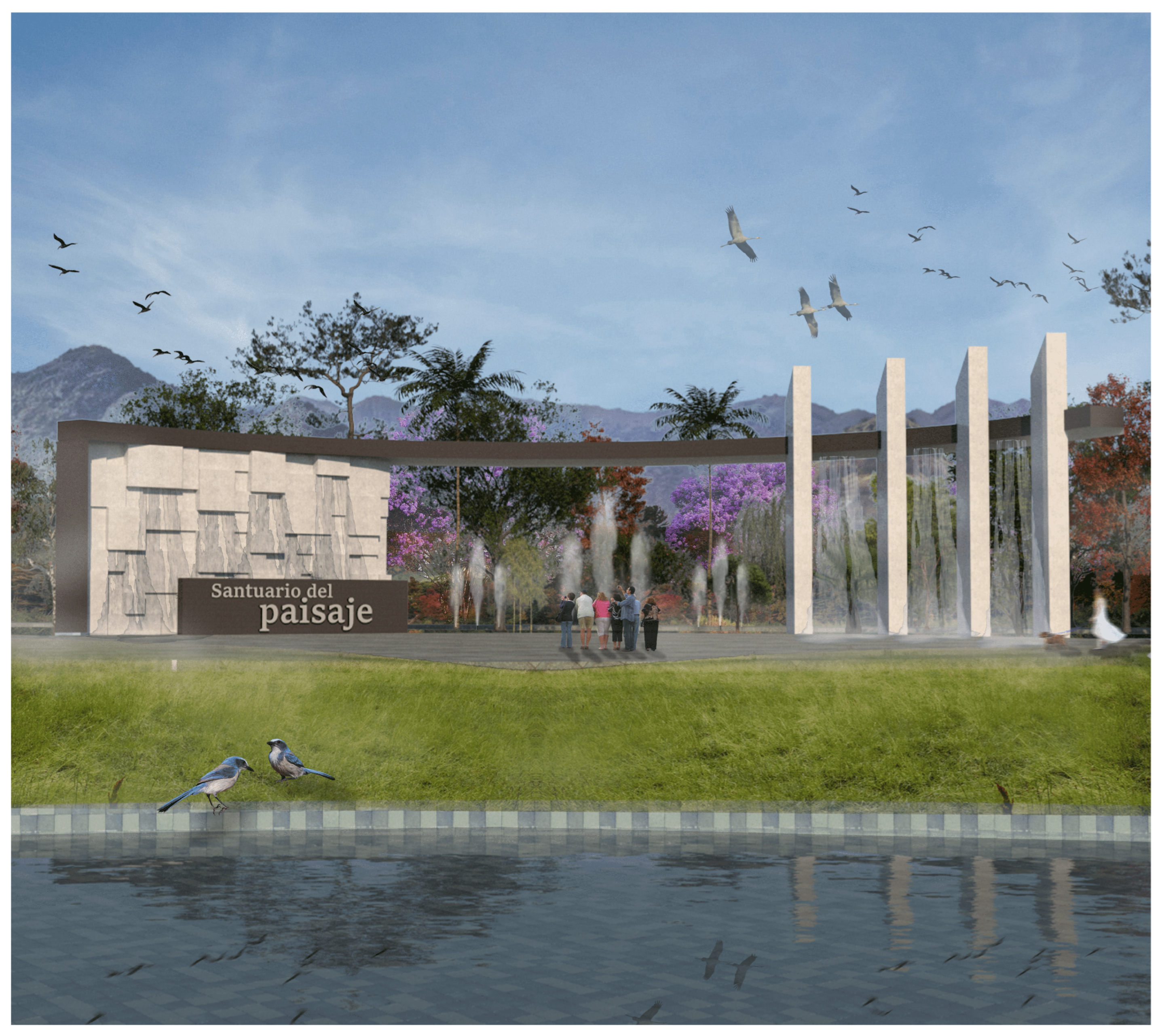
In Figure 22, the proposal for this sanctuary encompasses a detailed landscape intervention, integrating endemic flora species strategically placed according to the nearby public space type and desired microclimate. Emphasis is placed on the watercourse running through the proposal, as well as topographical interventions across the entire terrain.
Figure 16 portrays the main entrance of the proposal, featuring water elements like the “Apu” and stones inspired by Incan geometries. Public spaces were conceived based on principles and strategies employed by the Incas, such as “pirqas” and stone structures inspired by architectural styles found in sacred sites like Machu Picchu. Additionally, terrace cultivation systems known as “andenería” were implemented to create microclimates and support cultivation at various ecological levels.
3.3.1. Urban Design Strategies in the Proposal
Within the strategies for the development of the urban proposal, emphasis is placed on social integration, a sense of place-based identity, the utilization of clean energy and local products, and most notably, a profound connection with nature (Figure 23).
In the urban design strategies, they were formulated based on the Sustainable Development Goals and their alignment with Andean cosmovision, affording equal importance to communal life intertwined with nature, known as “ayni”. Additionally, these strategies integrate principles of economy founded on reciprocity and communal labor, referred to as “minka”.
3.3.2. Classification of Flora in the Urban Proposal
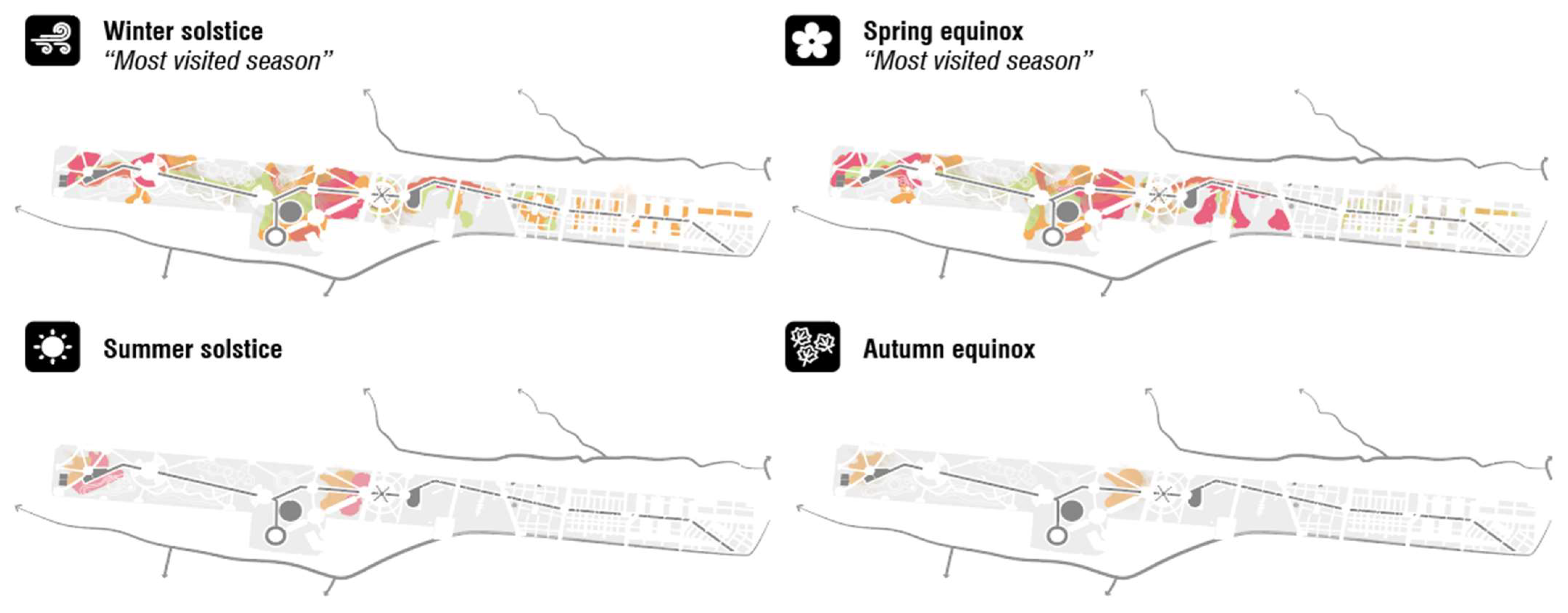
The landscape design is guided by the principle of cyclicality, where the “killa” (moon) marks the beginning of the cycle and calendar, including planting and harvesting seasons. In alignment with the Inca era, it is planned that cultivation within the sanctuary follows seasonal patterns. The aim is to establish controlled flowering zones that coincide with significant festivities, serving as a study area for professionals to comprehend the interaction and co-development of flora and fauna with human interventions. By aligning plant growth cycles with cultural celebrations, the sanctuary seeks to showcase the harmonious relationship between nature and human activities. This approach not only enhances the landscape’s beauty during festive periods but also serves as a learning opportunity for landscape professionals to observe and study how the interaction between humans and the natural environment can shape the development and interconnectedness of flora and fauna.
In Figure 24, the landscape’s color combination during different seasons can be observed, according to crops regulated by the lunar calendar, which served as the foundation for the Incas’ cyclical agricultural system. This connection between the lunar calendar and the blossoming of species has been passed down through generations in many traditional cultures. Some farmers and gardeners still employ this knowledge to determine the optimal timing for planting and harvesting, taking into account lunar phases.
3.4. Location of the Architectural Proposal
The architectural proposal’s location is influenced by its relationship with the mountains and the system of “ceques”, which are radial lines connecting sacred sites (huacas) in Cusco. The site is surrounded by a water element representing the “Apu” within the sanctuary. Additionally, these centers typically offer interactive exhibits, models, audiovisuals, and educational activities that enable visitors to explore and gain a better understanding of the natural world around them. The primary objective of an interpretation center is to promote the conservation and respect for flora and fauna, as well as to foster environmental awareness and ecosystem stewardship. The importance of biodiversity in the world cannot be underestimated. Biodiversity refers to the variety of living organisms, including plants, animals, and microorganisms, as well as the ecosystems in which they exist (Figure 25).
General Plan of the Proposal
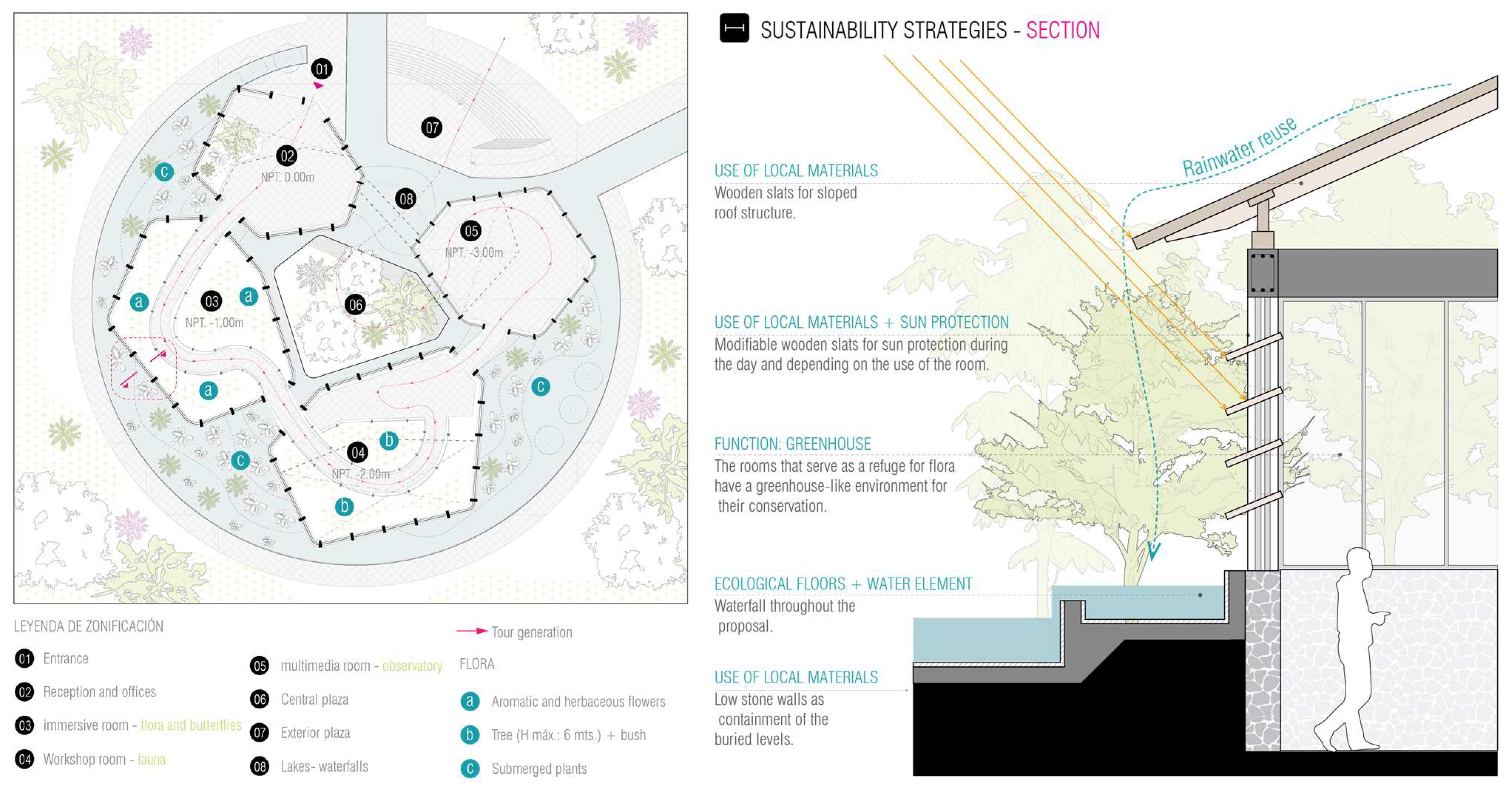
The architectural proposal was developed based on principles of social integration and a connection to nature, prioritizing spaces that have a contextual link. It also incorporates the element of water as the “Apu” of the sanctuary and the Interpretation Center. The establishment of a structured pathway facilitates and offers users the opportunity to traverse different environments that evoke distinct sensations, as these immersive spaces contribute to achieving the proposal’s objective, which is to raise user awareness regarding the current city context (Figure 26).
The architectural proposal incorporates various sustainability strategies, primarily the reuse of rainwater for the wetlands created within the design. This harvested rainwater will be employed for irrigating interior plants located in greenhouses and the plaza, as well as supplying the necessary water for services. Additionally, the use of local materials and construction techniques, such as stone walls to enhance thermal mass and wooden lattices for solar protection and ventilation, is another noteworthy aspect of the proposal.
In Figure 27, it can be observed that the green area represents 51% of the total land area, distributed throughout the proposal. Of this, 36% of the green area is located in the cultural zone. This contributes to the creation of microclimates, improved air quality, and aids in the preservation of wildlife habitats, as well as the optimal development of flora.
The increase in green areas resulting from the implementation of the green area in the interpretation center for the preservation of flora and fauna provides consistent results in the absorption of CO2 and production of clean air. These results were determined using conversion factors provided by the world health organization (WHO) [44], where:
where a = annually absorbed CO2 (kg for a year); b = green area studied, expressed in square meters.
where
a = 2.3 kg for one year.
c = 1.7 kg for a year,
c = annually produced fresh air (kg. year);
b = green area analyzed, expressed in square meters.
Hence, when calculating the results using these factors, the following was obtained.
Table 1 shows the amount of CO2 absorption, which represents 147 kg, producing a total of 108.80 kg of air.
4. Discussion
Among the strategies employed for the design of Gran Colombiano Park is the perception of the landscape as a living heritage, and the recognition of historical heritage as a continuation of events. Nevertheless, despite the local landscape’s significance, the park lacks adequate public spaces that encourage visitor stays and areas suitable for conveying its historical importance. Similarly, the proposed Wanchaq Sanctuary incorporates a range of sustainable strategies that promote landscape development while facilitating diverse types of public spaces. In the landscape regeneration of Cami de Cabrianes, the use of local materials is evident, but a suitable landscape proposal fostering interior microclimates is lacking [45]. Conversely, the Sanctuary proposal transforms the terrain to introduce terracing and varied sensory experiences, involving local materials such as stone and wood, along with well-known and easily executed construction systems.
The Salburua Wetland Interpretation Center, Ataria, features a series of strategies for design, including the dissemination of the ecological diversity’s significance on-site. Educational spaces about wetlands contributed to visitor influx and heightened user awareness, promoting local tourism. The initially dwindling tourism was addressed through the utilization of local materials and labor. Similarly, the proposed Interpretation Center for the revalorization of flora and fauna in Cusco shares a parallel objective with Ataria, the dissemination of biodiversity’s importance at both provincial and national levels. Peru, as one of the world’s 17 megadiverse countries, showcases remarkable diversity in climate, flora, fauna, and history. It employs local materials and ancestral construction techniques. Unlike Ataria, the Flora and Fauna Interpretation Center offers interactive and immersive spaces that develop the landscape and foster interior microclimates. Greenhouses and surrounding wetlands, alongside diverse fauna species, contribute to the attraction of wetland flora, aromatic flowers, and varied tree typology.
5. Conclusions
The urban proposal presents a diversity of public spaces, thanks to the various landscape proposals it encompasses, in addition to the significance of the canal, which serves as a connection to the Huatanay River. The canal features a series of filters due to the contamination of the river, using oxidation ponds and wetlands. This not only preserves endemic species but also contributes to the revaluation of the Huatanay River through the design strategies employed along its banks.
Based on the site analysis, a residential area was added to the terrain, functioning within a circular economy model, including areas for cultivation and greenhouses to produce food. There is also a commercial zone that supplies the residences. Furthermore, the proposal includes the presence of an agricultural CITÉ (neighborhood) for education on ancestral agriculture techniques, given their global importance.
These strategies work towards achieving the objective of the Interpretation Center, which is to generate awareness among visitors about the history of the area, to familiarize them with the reality of endemic flora and fauna, promote social integration, connect people with nature, and reinforce the community’s identity. It will also facilitate training for residents through workshops that aim to raise awareness and provide environmental education, addressing one of the issues facing the area. Additionally, the use of clean energy sources is a key factor in achieving sustainability [46].
The urban proposal proposes a series of public spaces, thanks to the various landscape proposals that it addresses, in addition to the implementation of a channel that serves as a connection with the Huatanay river and allows filtering the contamination of the river through the wetlands, thus managing to preserve endemic species and contribute to the revaluation of the Huatanay river.
The proposal for the Interpretation Center for the revaluation of flora and fauna is of great importance due to the various strategies employed, including the use of local materials and ancestral construction techniques, as well as the diversity of spaces, including greenhouses, immersive rooms, and workshops.
Author Contributions
Methodology, D.E.; conceptualization, W.M.; revision, V.R.; software, P.V. All authors have read and agreed to the published version of the manuscript.
Funding
This research received no external funding.
Data Availability Statement
All data are in the manuscript.
Conflicts of Interest
The authors declare no conflict of interest.
References
- Núñez, I.; González-Gaudiano, É.; Barahona, A. La biodiversidad: Historia y contexto de un concepto. Interciencia 2003, 28, 387–393. [Google Scholar]
- Burneo, S. Megadiversidad. Let. Verdes. Rev. Latinoam. Estud. Socioambientales 2009, 3, 6–7. [Google Scholar] [CrossRef]
- Esenarro, D.; Ruiz, S.; Raymundo, V.; Nizama, P.C.; Huaman, C.R.; Llanos, W.M. Use of Solar Energy in the design of the interpretive trail of the Antankallo waterfall in the district of Matucana, Peru 2022. In Proceedings of the 2022 International Conference on Electrical, Computer and Energy Technologies (ICECET), Prague, Czech Republic, 20–22 July 2022; pp. 1–6. [Google Scholar] [CrossRef]
- Martín-López, B.; González, J.A.; Díaz, S.; Castro, I.; García-Llorente, M. Biodiversidad y bienestar humano: El papel de la di-versidad funcional. Ecosistemas 2007, 16. Available online: https://www.revistaecosistemas.net/index.php/ecosistemas/article/view/94 (accessed on 29 May 2023).
- Silva, V. Centro de Interpretación del Patrimonio Marítimo DUBoak/NFO. Available online: https://www.archdaily.pe/pe/996373/centro-de-interpretacion-del-patrimonio-maritimo-duboak-nfo (accessed on 29 May 2023).
- Caballero, P. Centro de Interpretación del Románico/Spaceworkers. Available online: https://www.archdaily.pe/pe/937707/centro-de-interpretacion-del-romanico-spaceworkers (accessed on 29 May 2023).
- Pintos, P. Centro de Interpretación, Detalle Malinska, Croacia. 2022. Available online: https://www.archdaily.com/988793/duboak-maritime-heritage-interpretation-center-nfo (accessed on 29 May 2023).
- Pereira, M. Interpretation Center Lousada, Portugal. 2019. Available online: https://www.archdaily.com/928758/interpretation-centre-of-romanesque-spaceworkers (accessed on 29 May 2023).
- Bann, I. Mapungubwe Interpretation Centr /Peter Rich Architects. 2020. Available online: https://www.archdaily.com/57106/mapungubwe-interpretation-centre-peter-rich-architects (accessed on 29 May 2023).
- Dourojeanni, M.J. Áreas naturales protegidas e investigación científica en el Perú. Rev. For. Perú 2018, 33, 91–101. [Google Scholar] [CrossRef]
- Landa, E.Y. Biodiversidad y cambio climático: Diversidad de insectos en cuatro ecotipos de papa. Cambio Climático En Los Andes Trop. 2015, 2, 39–43. [Google Scholar] [CrossRef]
- Soledad, S.; Córdova, C.; Isaías, J.; Tume, A.; Alexis, A.; Sanz, S.; Simón, R.; Chinchay-Villarreyes, S.S. Estrategias de Promoción Para El Fomento Del Turismo Religioso En Perú. Available online: https://www.redalyc.org/journal/280/28063519020/28063519020.pdf (accessed on 29 May 2023).
- Escudero, C.G. Cosmovisión Inca: Nuevos Enfoques y Viejos Problemas; Universidad de Salamanca: Salamanca, Spain, 2010; ISBN 9788478001903. [Google Scholar]
- Bauer, B.S. The Sacred Landscape of the Inca: The Cusco Ceque System; University of Texas Press: Austin, TX, USA, 1998; ISBN 9780292708655. [Google Scholar]
- Guerra, A. The Coricancha, continuity and rupture in the Andean World. Surandino Rev. De Humanid. Y Cult. 2021, 2, 93–119. Available online: https://www.surandinorevista.pe/wp-content/uploads/2021/08/04-CORICANCHA.pdf (accessed on 29 May 2023).
- Bayona, D. 10 Archaeological Sites That Every Architect Should Visit in Peru. Available online: https://www.archdaily.com/882555/10-archaeological-sites-that-every-architect-should-visit-in-peru. (accessed on 14 June 2023).
- Velarde, N.D.S. Revisitando las cerámicas tempranas del sitio arqueológico de Marcavalle (Cuzco, Perú): Registro e identificación de pastas mediante microscopía digital portátil in situ. Arqueología 2023, 29, 11142. [Google Scholar] [CrossRef]
- Del Castillo De Loayza, T.; Maldonado, I.; Zirena Vilca, F. Identification and Quantification of Antibiotic Residues and Evaluation of Microbial Resistance to Antibiotics in Huatanay River Waters in Peru. Pollution 2023, 9, 1236–1250. [Google Scholar] [CrossRef]
- Firrone, T.; Bustinto, C. Intervention Strategies for the Enhancement of the Peruvian Route of the Inca Royal Path Qhapaq Ñan. In World Heritage and Dwelling on Earth: XXI International Forum ‘Le Vie dei Mercanti’; Gangemi: Roma, Italy, 2023; Volume 12, pp. 292–301. ISBN 9788849246476. [Google Scholar]
- Programa de Naciones Unidas para el Desarrollo. Qhapaq Ñan, un Símbolo de la Integración Regional Contemporánea. 2018. Available online: https://www.undp.org/es/ecuador/stories/qhapaq-%C3%B1an-un-s%C3%ADmbolo-de-la-integraci%C3%B3n-regional-contempor%C3%A1nea (accessed on 29 May 2023).
- Mendivel, R.; Ariiega, B.; Castañeda, J. Gestión del Agua en la Cuenca del rio Huatanay y la Concertacion para el Tratamiento de Problemas Ambientales. 2002. Available online: https://www.ima.org.pe/publicaciones/experiencias/PUB_huatanay.pdf (accessed on 29 May 2023).
- Mapa de Deforestación del Departamento de Cusco I. Available online: https://sinia.minam.gob.pe/mapas/mapa-deforestacion-departamento-cusco-i (accessed on 30 May 2023).
- Lozano-Povis, A.A. Agricultura y cambio climático: Principales hallazgos y propuestas para la toma de decisiones en dos regiones naturales del Perú. South Sustain. 2023, 4, e068. [Google Scholar] [CrossRef]
- Gobierno Regional Cusco. Available online: https://www.gob.pe/institucion/regioncusco/informes-publicaciones/3689584-proyecto-plan-de-desarrollo-regional-concertado-de-cusco-al-2033 (accessed on 30 May 2023).
- Trujillo, D.; Edquén, J.D.; Rizo-Patrón, F.; Calatayud, G.; Dipaz, A.G.; Salazar, G.A. Redescubrimiento de Chloraea multilineolata (Orchidaceae, Chloraeinae), una especie peruana en peligro de extinción. Acta Bot. Mex. 2023, 130, e2182. [Google Scholar] [CrossRef]
- Comité Provincial de Seguridad Ciudadana—COPROSEC CUSCO Quinto Paradero de Ttio|CEGESEC|084 221118 Www.Cusco.Gob.Pe Jmc. Available online: https://cusco.gob.pe/wp-content/uploads/2021/04/PAPSC-CUSCO-2021.pdf (accessed on 30 May 2023).
- Huamantupa-Chuquimaco, I.; Trujillo, Y.L.M.; Ucamayta, E.O. Valuation of the Diversity of Native Plants and the Cultural-Archaeological Richness as an Integrative Approach for a Potential Use in Ecotourism in the Inter-Andean Valley of Cusco, Southern Peru. Diversity 2023, 15, 760. [Google Scholar] [CrossRef]
- Esenarro, D.; Chicche, P.; Chichipe, V.; Vilchez, A.; Cobenas, P.; Raymundo, V. Bioclimatic Criteria for a Guest House in the District of Canta–Lima. In Proceedings of the 2022 11th International Conference on Power Science and Engineering (ICPSE), Eskisehir, Turkey, 23–25 September 2022; pp. 1–9. [Google Scholar] [CrossRef]
- Yapura, W.B. Santuarios, oráculos, montañas y orden sagrado en la cordillera del Vilcabamba-Cusco. Arqueol. Y Soc. 2021, 2021, 325–350. [Google Scholar] [CrossRef]
- Asociación de Ingeniería Aeroportuaria Del Perú AIA – PERÚ. Evaluación y Alternativa de Solución al Problema de Ahuellamiento en la Calle de Rodaje del Aeropuerto Teniente Alejandro Velasco Astete" del Cusco. 2014. Available online: https://www.icao.int/SAM/Documents/2014-ALACPA11/DIA%204%20-%203_Mora-Ahuellamiento%20TWY%20AD.%20Cusco.pdf (accessed on 29 May 2023).
- Alfaro Curitumay, L.E.; Paiva Prado, G.M.; Espinoza Carrasco, H.Y.; Monteagudo Mendoza, A.; Chávez Huaman, W. Dinámica, Biomasa Aérea y Variables Poblacionales de Dos Parcelas Permanentes En Bosques Montanos de Wiñaywayna, Santuario Histórico de Machupicchu, Cusco, Perú. Arnaldoa 2018, 25, 631–652. [Google Scholar] [CrossRef]
- Pérez, M.A.C. Cosmovisión andina e interculturalidad: Una mirada al desarrollo sostenible desde el sumak kawsay. Rev. Chakiñan Cienc. Soc. Y Humanidades 2018, 119–132. [Google Scholar] [CrossRef]
- Aseto, J. El Cambio Recíproco entre los Aymaras. Cienc. Y Cult. 2016, 37. Available online: http://www.scielo.org.bo/pdf/rcc/v20n37/v20n37_a05.pdf (accessed on 29 May 2023).
- Let, M.; Pal, S. Socio-ecological well-being perspectives of wetland loss scenario: A review. J. Environ. Manag. 2023, 326, 116692. [Google Scholar] [CrossRef]
- Arizaga, X. Espacios de uso público en los conjuntos habitacionales del movimiento moderno: El ambiente urbano en tres casos de Santiago de Chile. Ciudades 2023, 21–45. [Google Scholar] [CrossRef]
- Khan, A.S. A Comparative Analysis of Rainwater Harvesting System and Conventional Sources of Water. Water Resour. Manag. 2023, 37, 2083–2106. [Google Scholar] [CrossRef]
- BBC News Mundo Perú: La técnica ancestral que mantiene vivo el Q’eswachaka, el último puente inca en uso con al menos 6 siglos de antigüedad. BBC, 12 November 2018. Available online: https://www.bbc.com/mundo/noticias-45882911 (accessed on 29 May 2023).
- Marca Perú. El Cóndor Andino: Conoce Más Sobre una de las Aves Más Majestuosas de Nuestros Cielos. Available online: https://peru.info/es-pe/turismo/noticias/3/17/el-condor-andino--conoce-mas-sobre-una-de-las-aves-mas-majestuosas-de-nuestros-cielos (accessed on 25 July 2023).
- Marca Perú. ¿Cómo los Flamencos Influenciaron en la Creación de la Bandera Peruana? Available online: https://www.peru.travel/es/masperu/como-los-flamencos-influenciaron-en-la-creacion-de-la-bandera-peruana (accessed on 25 May 2023).
- EBird. Pato de Torrente. Available online: https://ebird.org/species/pigdov1?siteLanguage=es_AR (accessed on 12 May 2023).
- Birds Colombia. Pato de Puna/Puna Teal/Spatula Puna. Available online: https://birdscolombia.com/2023/06/19/pato-de-puna-puna-teal-spatula-puna/ (accessed on 12 May 2023).
- EBird. Águila Mora. 2020. Available online: https://ebird.org/species/bcbeag1?siteLanguage=es (accessed on 17 July 2023).
- EBird. Andean Duck. 2021. Available online: https://ebird.org/peru/home (accessed on 15 July 2023).
- Gómez, A.; Esenarro, D.; Martinez, P.; Vilchez, S.; Raymundo, V. Thermal Calculation for the Implementation of Green Walls as Thermal Insulators on the East and West Facades in the Adjacent Areas of the School of Biological Sciences, Ricardo Palma University (URP) at Lima, Peru 2023. Buildings 2023, 13, 2301. [Google Scholar] [CrossRef]
- Foncea, J.F.; Escobar, M.A.H.; Villaseñor, N.R. Respuestas de la comunidad de aves a las variables del hábitat local y del paisaje en la ciudad de Santiago de Chile. Ecol. Austral 2023, 33, 455–468. [Google Scholar] [CrossRef]
- Raymundo, V.; Esenarro, D.; Rodríguez, C.; Davila, S.; Prado, M.; Veliz, M. Biodigester Application to Generate Electricity and Improve the Quality of Life. In International Conference on Intelligent Technologies; Springer Nature Singapore: Singapore, 2023; pp. 29–42. [Google Scholar] [CrossRef]
Figure 1.
Map of megadiverse countries.

Figure 2.
(a) Maritime Heritage Interpretation Center DUBoak in Croatia, reprinted with permission from Ref. [7], 2023, Pintos; (b) Romanesque Interpretation Center in Portugal, reprinted with permission from Ref. [8], 2023, Pereira and (c) Mapungubwe Interpretation Center in South Africa, reprinted with permission from Ref. [9], 2023, Bann.

Figure 3.
Diversity data in ecosystems, climates, fauna, and flora.

Figure 4.
Highly significant constructions for the Inca civilization (a) Coricancha, reprinted with permission from Ref. [14], 2010, Escudero; (b) Sacsayhuaman, reprinted with permission from Ref. [15], 2021, Guerra.

Figure 5.
Current Issues with (a) Qhapaq Ñan, reprinted with permission from Ref. [20], 2018, Programa de Naciones Unidas para el Desarrollo; (b) the Huatanay River Due to Solid Waste Disposal, reprinted with permission from Ref. [21], 2022, Mendivel.

Figure 6.
Diagram of research stages.

Figure 7.
Steps for the implementation of the proposal.

Figure 8.
Location of Cusco Province.

Figure 9.
Climatic analysis of Cusco.

Figure 10.
Flora and fauna of Cusco.

Figure 11.
Location of the urban proposal.

Figure 12.
Contest place of intervention and area.

Figure 13.
Zoning of intervention area.

Figure 14.
Automobile flows of intervention area.

Figure 15.
Conceptualization.

Figure 16.
Urban conceptualization.

Figure 17.
Plan general de la propuesta urbana.

Figure 18.
Wastewater treatment system.

Figure 19.
Wetlands.

Figure 20.
Endemic and migratory avifauna in Cusco (a) Vultur gryphus, reprinted with permission from Ref. [38], 2023, Marca Peru; (b) Phoenicoparrus andinus, reprinted with permission from Ref. [39], 2023, Mara Perù; (c) Merganetta armata, reprinted with permission from Ref. [40], 2023, Ebird; (d) Anas Puna, reprinted with permission from Ref. [41], 2023, Ebird; (e) Oxyura ferruginea, reprinted with permission from Ref. [42], 2023, Birds; (f) Geranoaetus melanoleucus, reprinted with permission from Ref. [43], 2023, Ebird.

Figure 21.
Cross-section of the urban proposal.

Figure 22.
View of the sanctuary entrance.

Figure 23.
Urban design strategies in the proposal.

Figure 24.
Representation of the lunar calendar in the blooming of species.

Figure 25.
Location of the architectural proposal.

Figure 26.
General site plan of the architectural proposal and sustainability strategies.

Figure 27.
Green area plan.


Table 1.
Absorbed CO2 and produced fresh air annually.
| Floor | Green Wall (H2) | Absorbed CO2 (kg) | Produced Fresh Air (kg) |
|---|---|---|---|
| 1 | 64 | 147.20 | 108.80 |
| Total | 64 | 147.20 | 108.80 |
Disclaimer/Publisher’s Note: The statements, opinions and data contained in all publications are solely those of the individual author(s) and contributor(s) and not of MDPI and/or the editor(s). MDPI and/or the editor(s) disclaim responsibility for any injury to people or property resulting from any ideas, methods, instructions or products referred to in the content. |
© 2023 by the authors. Licensee MDPI, Basel, Switzerland. This article is an open access article distributed under the terms and conditions of the Creative Commons Attribution (CC BY) license (https://creativecommons.org/licenses/by/4.0/).
Share and Cite
MDPI and ACS Style
Esenarro, D.; Vasquez, P.; Morales, W.; Raymundo, V. Interpretation Center for the Revaluation of Flora and Fauna in Cusco, Perú. Buildings 2023, 13, 2345. https://0-doi-org.brum.beds.ac.uk/10.3390/buildings13092345
AMA Style
Esenarro D, Vasquez P, Morales W, Raymundo V. Interpretation Center for the Revaluation of Flora and Fauna in Cusco, Perú. Buildings. 2023; 13(9):2345. https://0-doi-org.brum.beds.ac.uk/10.3390/buildings13092345
Chicago/Turabian StyleEsenarro, Doris, Patricia Vasquez, Walter Morales, and Vanessa Raymundo. 2023. "Interpretation Center for the Revaluation of Flora and Fauna in Cusco, Perú" Buildings 13, no. 9: 2345. https://0-doi-org.brum.beds.ac.uk/10.3390/buildings13092345
Note that from the first issue of 2016, this journal uses article numbers instead of page numbers. See further details here.