Sand Seas and Dune Fields of Egypt


1
Im Neuenheimer Feld 348, Institute of Geography and Heidelberg Center for the Environment, Heidelberg University, 69120 Heidelberg, Germany
2
Department of Geography, Faculty of Arts, Ain Shams University, Cairo, El-Khalyfa El-Ma’moun Street Abbasya, Egypt
*
Author to whom correspondence should be addressed.
Geosciences 2020, 10(3), 101; https://0-doi-org.brum.beds.ac.uk/10.3390/geosciences10030101
Submission received: 22 August 2019
/
Revised: 16 February 2020
/
Accepted: 5 March 2020
/
Published: 10 March 2020
(This article belongs to the Special Issue Aeolian Processes and Geomorphology)
Abstract
:The article reviews the state of knowledge about distribution, sizes, dynamics, and ages of all sand seas (N = 6) and dune fields (N = 10) in Egypt (1,001,450 km2). However, chronological data (Optically Stimulated Luminescence, Thermoluminescence), used in the INQUA (International Union for Quaternary Research) dune database, only exists from three of the five sand seas located in the Western Desert of Egypt. The North Sinai Sand Sea and four of the ten dune fields are located near the Nile Valley, the delta or the coast and therefore changed drastically due to land reclamation during the last decades. Here, but also in the oases, their sands pose a risk for settlements and farmland. Our comprehensive investigations of satellite images and our field measurements show that nearly all terrestrial dune forms can be observed in Egypt. Longitudinal dunes and barchans are dominant. Sand seas cover about 23.8% (with an average sand coverage of 74.8%), dune fields about 4.4% (with an average sand coverage of 31.7%) of its territory. For the Great Sand Sea and the Farafra Sand Sea, situated in the central and northern part of the Western Desert, a Late Glacial transformation by strong westerlies was found, but not for the Selima Sand Sea, situated in the south of Egypt. Regarding the sparse chronological data up to now, for a reasonable estimation of future sand mobility in the course of global climate change, further data are essential. Finally, further studies concerning sand mobility, local wind systems, and land use are needed.
1. Introduction
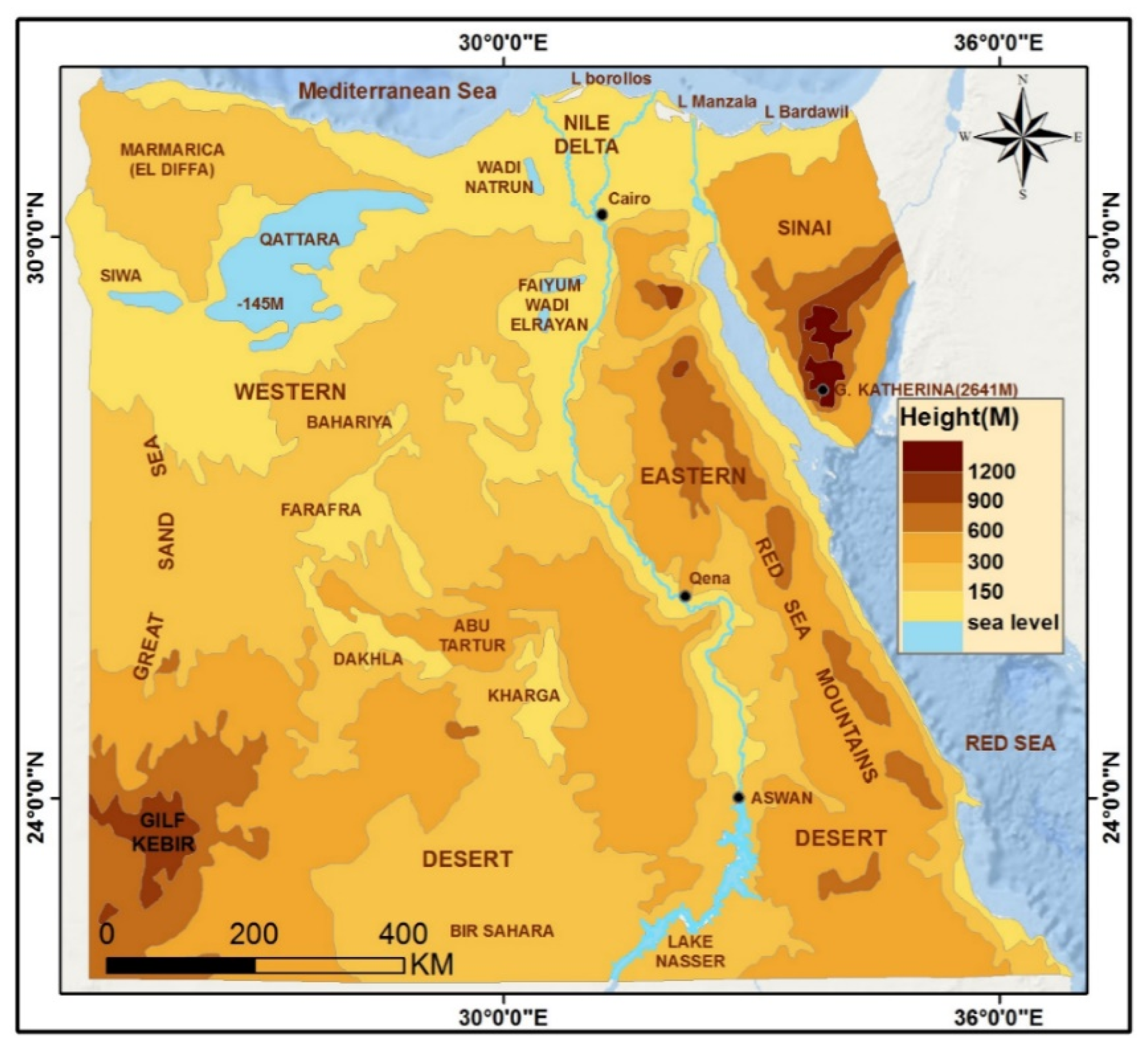
Egypt covers an area of ~1,001,450 km2, taking the neat shape of a square. Geographically, Egypt can be divided into four regions: the Nile Valley, the Western Desert, the Eastern Desert, and Sinai Peninsula (Figure 1).
The Nile enters Egypt from the south, and runs northwards till it reaches the Mediterranean Sea for ~1200 km. It is bordered by a valley which widens northwards, reaching its widest section (~20 km) at the latitude of Beni Suef City. A few kilometers north of Cairo, the Nile Delta starts where the Nile branches into two distributaries (Rosetta and Damietta), representing what is left from several others. Because of the similarity between their triangular shape and the Greek letter Δ, Herodotus (450 BC) called it delta. Both the Nile Valley and the Delta covers ~3.5% of the total area of Egypt. Along the northern, western and eastern margins of the Nile Delta, and the western side of the Nile Valley, sand accumulated at several localities forming small dune accumulations.
The Western Desert is the largest region in Egypt. It covers roughly two-thirds of its total area and is characterized by dunes, plateaus, depressions, and plains. Heights above 1000 m are present in the vicinity of the Gilf El-Kebir and Abu Ras plateaus and Uweinat Mountain, whereas areas below sea level can be found in the northern depressions (Qattara −145 m, Siwa −22 m, Wadi El-Natrun −20 m, Wadi El-Rayan −65 m, El-Fayum −45 m). There are innumerable closed depressions in the Western Desert, which vary in size from minute ones to huge basins such as the Qattara Depression (about 18,000 km2). Dunes spread all over this region as sand seas, dune fields, or sand sheets, of which the Great Sand Sea is the largest and for which the most chronological data are available [1]. Vast plains occupy the southern part of this desert, extending into northern Sudan, notably the Selima Sand Sheet [2,3]. Another plain lies between the northern (El Diffa/Marmarica) Plateau and the Mediterranean, which, as a coastal plain, is characterized by the presence of linear limestone ridges that extend parallel to the coastline.
The Eastern Desert is the second largest region in Egypt and covers roughly one quarter of the country’s total area. It is the region of mountains, plateaus, and large wadi nets. The Red Sea Mountains divide the wadis into two groups: eastern ones that go to the Red Sea, and western wadis that run towards the Nile Valley. Examples are the Wadi Araba, which run towards the Red Sea and separates the two mountain ridges (Galalahs), whereas Wadi Qena runs towards the Nile Valley. Altitudes above 1000 m above sea level (m asl) are present on both the plateaus and mountains. Several peaks in the Red Sea Mountains rise to altitudes of 2000 m or more, such as Gabal El-Shayeb (2187 m asl, latitude 27° N). Low-lying areas are present firstly in the El-Mallaha Basin as part of the coastal plain of the Red Sea south of Ras Ghareb and are occupied by a sabkha and salina. Here, heights are only a few meters above sea level. The second low-lying area is situated at the northern margin of this Desert between Sinai and the Delta. Here, heights decrease gradually from 200 m asl at the latitude Cairo-Suez to a few meters above sea level around El-Manzalah Lake. It is covered by fluvial materials deposited by the wadis coming from the south. Apart from the El-Khanka dune field that lies just to the east of Cairo, sand accumulations are concentrated in the extreme southeast of this desert, where four small dune fields are developed.
The Sinai Peninsula has a triangular shape, bounded by the Mediterranean coast from the north, the Gulf of Aqaba and the border to Israel from the east, and the Gulf of Suez and the Suez Isthmus from the west. It covers about 6% of the total area of Egypt. Nearly all geologic formations, structures, and landforms of Egypt are represented here. High mountains with igneous and metamorphic rocks dominate the landscape in the south, whereas vast limestone plateaus (El-Tih and El-Egma) cover its central parts (Figure 1). The northern section is divided into two subregions, where domal/anticlinal mountains and hills dominate the landscape in the south, while a sandy plain covers its northern parts up to the Mediterranean coast. Bardawil Lake presents a unique form in the coastal plain. Several sabkhas spread around this lake, and extend eastwards, westwards and inland.
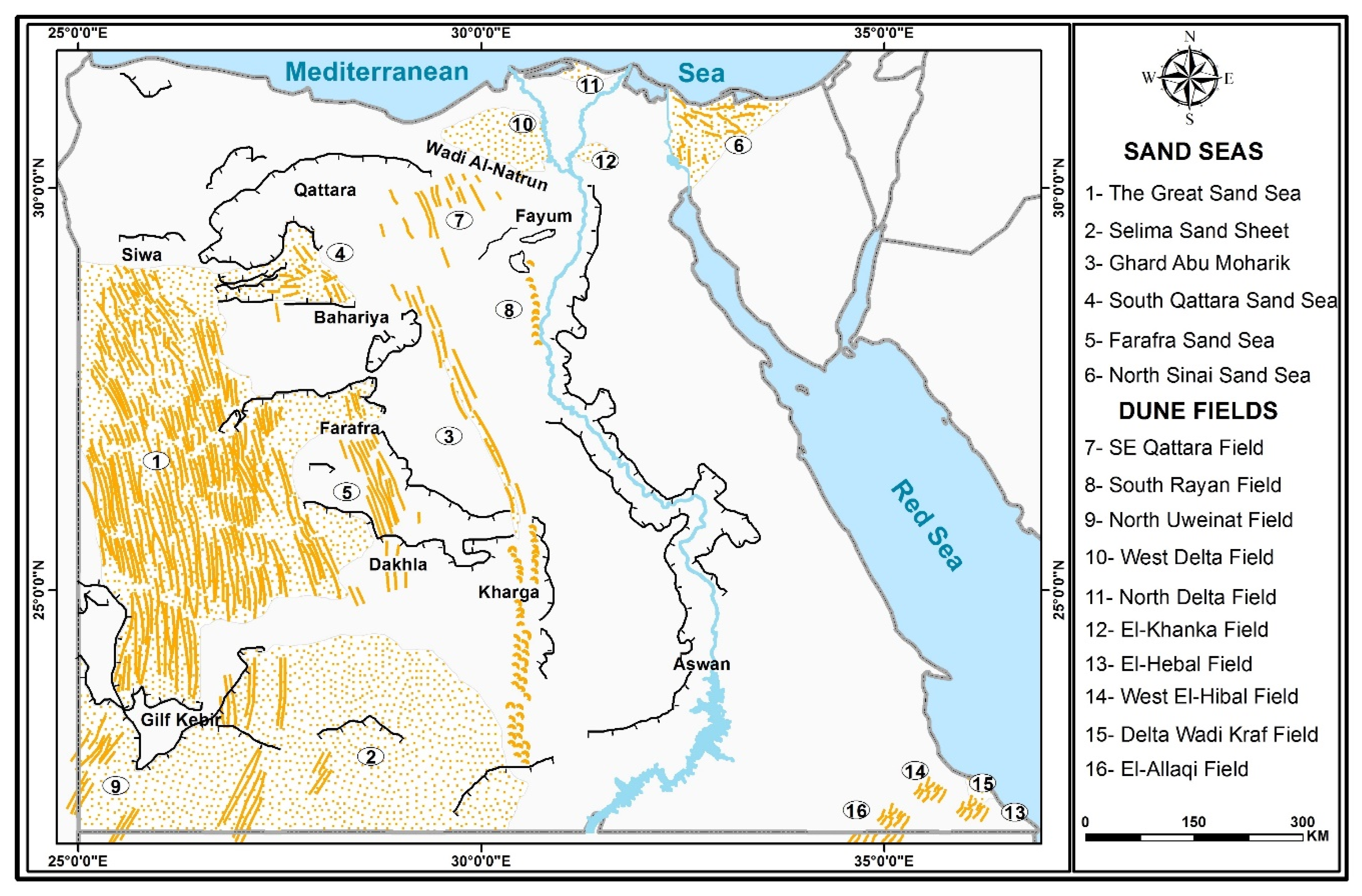
Sand accumulations are present in nearly all regions of Egypt. They cover parts of variable areas (from a few hundred square kilometers to more than hundred thousand kilometers). In dune literature, these sand covered areas are called sand seas or dune fields [4,5,6,7]). Several geomorphologists have considered that sand seas cover a minimum area of 125 km2 [5,6,7]. Previous studies agreed that sand seas should cover wider areas than dune fields and very often contain mega dunes or draa [4]. However, none of them made a numerical distinction between these two groups in Egypt. Here, we take two criteria into consideration: the total area and the percentage of dune coverage in it. In this regard, for the study at hand, the minimum area of a sand sea is 5000 km2 with dune coverage of at least 50%, whereas dune fields cover smaller areas with dune coverage less than 50%. However, a dune field may cover an area exceeding the minimum area of a sand sea, but with less than 50% dune coverage. In 1998, available tools made it possible to recognize six sand seas and four dune fields [8]. Later, due to the availability of high-resolution space images it was possible to recognize another four fields. Finally, careful examination of Google Earth Images added two more fields in the SE Eastern Desert (Figure 2). Although there are three small sand accumulations visible on Google Earth images along the western side of the Nile Valley, they cannot be considered as dune fields.
Except for the North Sinai Sand Sea, all other Egyptian sand seas are located in the Western Desert, whereas the dune fields of the Eastern Desert concentrate in the extreme SE (El-Hebal Dune Fields) and in the NE (El-Khanka Dune Field). All other dune fields and sand seas are developed in the Western Desert, namely the Great Sand Sea. This characteristic was explained by the fact that, among other factors, huge quantities of fluvial sediments during the Tertiary and Quaternary wet climatic periods were deposited in various parts of the Western Desert [9,10,11,12]. In the southern part, the formations mainly belong to the “Nubian Sandstone” with a high potential for aeolian sands [13]. With regard to the recent winds, Hereher [14] deduced that significant aeolian sand deposits are situated in today’s low-energy wind environments. On the other hand, some previous studies concluded that most of the sand seas and dune fields developed in topographic lows [15]. In sum, sand seas (with about 24%) and dune fields (with about 4%) cover in total about 28% of the area of Egypt (Table 1). The following chapters review the knowledge about their distribution, sizes, dynamics, and ages. In addition, hazards caused by sand encroachments are treated.
2. Sand Seas
The term “sand sea” is often used because found (mega) dunes resemble the waves of the ocean [11]. However, the term is also used for large plains without distinct dunes, e.g., the Selima Sand Sea. Therefore, for the study at hand the minimum area of a sand sea is defined as 5000 km2 and with a dune coverage of at least 50%.
2.1. The Great Sand Sea
The Great Sand Sea (GSS) got its name from Rohlfs [16], who mentioned the term with regard to the dune landscape to the west of Dakhla and Farafra [17]. It covers an area of about 114,400 km2 [8,10] and stretches in a direction of NNW-SSE (Figure 2) over about 600 km from the Siwa Oasis in the north to the Gilf Kebir Plateau in the south of Egypt.
2.1.1. Forms and Patterns
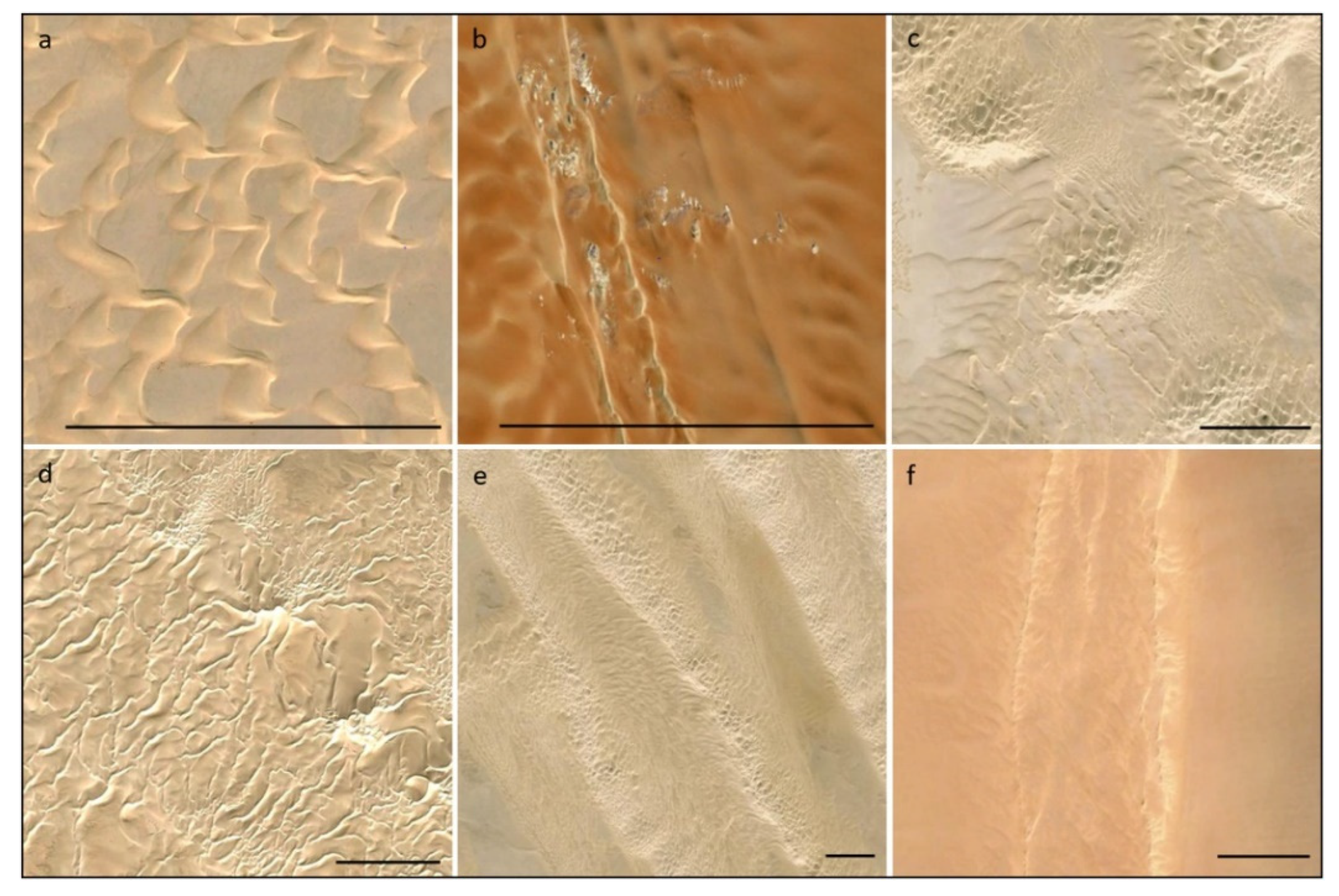
Striking are the about 60 regular longitudinal draa (or megadunes, after Warren [18]), which are superimposed by silk dunes and have nearly sand free interdraa corridors [2,11,13,19,20]. In the southern part, the silk have nearly the same general direction as the underlying draa (Figure 3f). For this reason, this constellation is not easily distinguishable on satellite images [21]. The GSS is underlain by Upper Cretaceous formations dipping approximately north and therefore getting younger in this direction, reaching an Early Tertiary age near Siwa. In the southern part, the formations mainly belong to the “Nubian Sandstone” with a high potential for aeolian sands. Even the silt and clay stones of the Dakhla Formation, which form the prominent Ammonite Scarp in the eastern part, contain sands of the aeolian main fraction (0.125–0.250 mm). The ground slopes from 500 m asl at 25° N towards 200 m asl at 27° N with a mean gradient of 1.36‰ (Table 2, [13]). A reduced topography (and friction) in the western part explains the divergence of the sand ridges towards the south [20]. The longitudinal draa of the GSS trend southwards (180°) in its western part and, because of the rougher surface in the eastern part, were deviated (165°) by the increased friction [13]. The draa wavelength is 2.5–3 km, getting more regular towards the east. The rocky surface of the interdraa corridors is covered by sands north of a line from 25°25′ N in the west to 26°40′ N in the east. Respectively, the southern border of the sand sea is receding from the Gilf Kebir in the west to 25° N (including dunes) in the east, caused by a decreasing sand supply. This is also expressed in the width of the draa, which is reduced from 1.5 km in the west to 0.7 km in the east, and by their heights as well, which decrease from 40–50 m in the west to 20–30 m in the east [11].
In addition to the dominant linear form, there are other forms of dunes which are less frequent, but scientifically significant. Of these forms are the star dunes in the northern margins of the GSS. This form is recently discovered not only here, but also in the South Qattara Sand Sea (Figure 3d) on Google Earth images [10]. They are composed of numerous sinuous arms, radiating from a central peak. In this aspect, they differ from star dunes reported in other deserts of the world, which have three to four arms only [22,23]. Star dunes develop in a multidirectional wind environment [22]. The nearest meteorological station is that of Siwa in the heart of large depression, lying about 20 km to the east of the star dunes. Climatic data of this station shows that wind in this region is multidirectional.
2.1.2. Sand Properties
Sand properties of the Great Sand Sea were studied by several researchers of which those of [11] are the most comprehensive. Results of these previous studies revealed that most of the samples are composed of sands in the medium to fine fractions. This is in accordance with the results of previous studies on other Egyptian sand seas [9] or on other sand seas in other deserts [20]. Coarse sands are found at the plinths of draa ridges, where they represent the particles left behind as winds remove finer grains. Distribution of sand grains showed that all samples are unimodal, except for those of the plinths which are bimodally distributed due to the presence of coarse sand grains.
Scanning electron microscopy of sand grains of the GSS reflect mechanical and chemical features on their surfaces. Mechanical features such as holes and cracks were recorded by Besler [11], while chemical features such as pits with cracks and grooves were recorded by EL-Baz and Prestel [24]. Kaolinite coatings were found on quartz grains at the floor of Wadi Bakht on the eastern side of the Gilf El-Kebir [24].
All previous studies on the minerals of the sands of the GSS concluded that they are mainly composed of quartz with small amounts of feldspar and calcareous materials. Previous studies on heavy minerals showed that they represent 0.27–1.0% of its content. These variations were attributed to differences in sand sources and/or local variations in wind velocities during the development of draa [11]. Due to its significance, the percentage of the ultrastable minerals (zircon, tourmaline and rutile, ZRT) of the total nonopaque minerals was found to be 58.2% and 54.1% by Embabi [9] and Besler [11] consecutively. This high occurrence of ZTR indicates the recycling of sands several times [25]. From this assumption, it can be inferred that the sands of the GSS have been recycled/reworked from older sediments.
2.1.3. Source of Sands
The source of the sands, not only of the GSS, but also other sand accumulations in Egypt, has drawn the attention of geologists since the early years of the 20th century [17,26]. Until recently, most authors adopted the views of Beadnell [26] that sands composing the dunes of the Western Desert must have been derived from the formation of the northern parts of the Western Desert. Ball [17] argued that the sands of the dunes have been derived from the great depressions that extend from Siwa in the west to Wadi El-Natrun in the east, where fine sediments of the Miocene and Oligocene are inexhaustible. More recently, El-Baz and Prestel [24] postulated from their observations of drainage lines in the Western Desert heading northwards towards the Mediterranean and eastwards towards the Nile that the sands of the Western Desert originated from the Nubian sandstones and other sandstones exposed in the southern part of this Desert. According to them, the sand was most likely transported to the northern part by drainage lines during past wetter periods. When the climate became drier, an aeolian regime was set up and sand was transported southwards by northern winds. Recently, these observations were confirmed by the analysis of digital elevation data [12].
Embabi [8] suggested another source for the sands not only for the GSS, but also for the sands of the Western Desert as a whole. During the Oligocene and Mid and Late Miocene, ancient streams from the Red Sea Mountains brought huge quantities of fluvial materials (mainly quartz) and deposited it on the surface of the Eocene Plateau and on other parts of the Western Desert. Owing to the location of the GSS between Siwa Depression in the north and the Gilf Kebir in the south, it was suggested that the eroded material from Siwa was transported to the GSS by the northern winds. This suggestion is confirmed by finding of signs of Moghra sands in the northern parts of this sand sea [11]. On the other hand, all the eroded material (mainly sands) from the sandstone plateaus of the Gilf Kebir was transported by the streams dissecting these plateaus, such as that of Wadi Abdel-Malik, and heading northwards, depositing their load into the basin the GSS [9].
2.1.4. Age
According to the results of four interdisciplinary expeditions [11,27], luminescence dating (sampling method see [28], optically stimulated luminescence dating (records AFNL 00001–AFNL 00016 in the dune database, comp. [1]) by the use of the single-aliquot regenerative-dose (SAR) protocol [29,30] and sediment analyses, such as granulometry, scanning electron microscopy, X-ray diffractometry, and salinity, the following landscape development is suggested [11]. Before and during the last glacial maximum (>20 ka cal BP), the longitudinal draa were modeled by strong trade winds [21,31]. Because of the geomorphological conditions, in particular the flat underlying terrain, the determining morphometric and sedimentological factors and the enhanced pressure gradient, that give rise to higher wind velocities, it is likely that the draa formation took place due to helical roll-vortices. This deduction is supported by the relatively coarse mean grain size of the draa sands, which indicates higher wind speeds, and the wavelengths of the draa that coincide with twice the height of the Planetary Boundary Layer (comp. [32]). In the northern part of the GSS, strong westerlies lead, most probably, to a formation of transverse draa in the time span between around 20 and 11 ka cal BP. At the end of the Pleistocene (12–10 ka cal BP), the strong and dry westerlies pushed further to the south and deposited sand on the eastern slopes of the draa. Therefore the western flanks of the draa show, due to erosion during that time span, older ages of sand deposition near the surface than the eastern flanks (accumulation). According to optically stimulated luminescence data (OSL) and the fact that the original symmetry of the draa was not altered significantly as observed further north [20], this was only a short period. During the Holocene humid phase or Holocene humid optimum (~10.6–7.3 ka cal BP, [2,29,33,34], runoff after annual precipitation amounts of 50–100 mm and intermediate short deflation phases [11,29,35] shaped the draa into the present whalebacks (after Bagnold [19,36]). Runoff from the slightly consolidated draa surfaces and seepage at their bases supplied water for shallow episodic or seasonal ponds and lakes in shallow depressions of the interdraa corridors. These conditions allowed humans to live there as hunters and gatherers [37]. Due to weathering during the Holocene humid phase, these so called playa sediments show red colors and higher silt contents in the southern GSS in comparison to the draa and dune sediments. The sand-sized fraction was incorporated into the modern dunes where patches of red sands are found in many places of the investigated areas of the southern GSS [13]. After approximately 7 ka cal BP, the modern hyper-aridity started and since about 5 ka cal BP more and more sand was reactivated. As a result of the weaker winds, the draa bodies remained stable, and only between one and four silk were formed on their tops, built by a bimodal wind regime. Their heights vary between 5 and 30 m whereas the underlying draa have average heights of 50 m. The eastern part of the southern GSS shows a considerable progression of the Holocene modern dunes south of the Pleistocene draa of about 60 km [21]. Bubenzer et al. [29] showed that, although the resolution of the OSL data is up to ten times lower than that of the radiocarbon data, the former can provide alternative and more compatible ages than 14C data and can expand chronologies.
2.2. The Selima Sand Sea (Selima Sand Sheet)
The Selima Sand Sea (SSS) is considered as “calm” according to Bagnold’s definition [3,38]. It is named after the famous Selima Oasis in N Sudan, about 80 km S of the Egyptian–Sudanese border, and extends eastwards about 400 km from the high ground of the Gilf Kebir, and northwards from the Egyptian-Sudanese borders for about 250 km (Figure 2). Most of its surface rises 200–250 m asl, except for the high rocky exposures interrupting the monotonous flatness of the sheet such as the Black Hill (500 m asl). In addition to the principal sand sheet, giant ripples and dune belts occur in several localities. The extreme flatness is a reflection of the subsurface. It is slightly undulating with some irregularities, e.g., shallow basins, which are several meters deep and as wide as 20–25 km. Beneath the sand sheet, a buried topography of fluvial origin was revealed [39].
Dune belts are gathered into three groups situated along the axis of the main dune belts at Kharga, Dakhla and the eastern margins of the Great Sand Sea. Each belt is composed of several barchans trending 15° E, except for the dunes of the central group, known as “Abu Hussein Dunes” [40], which are trapped in a shallow depression. Beside these dune belts, undulations developed on the surface of the sand sheet, especially around the Bir Misaha, covering an area of several hundred square kilometers. They are called “giant ripples” in some previous studies [39]. Measured on Landsat TM images, they attain amplitudes of about 10 m and wave length of 0.5 km. Unlike dunes, these ripples do not show slip faces, and consist of swells and hollows with internal horizontal planes [39], hence lacking dipping fore-sets. These characteristics do not reveal their mode of development. The surface of the sand sheet is covered by coarse pebble-sized granules (20–25 mm thick), which protect medium to coarse sands. The maximum thickness of the sheet is unknown but is expected not more than a few meters [2]. Granule-size grains exhibit close packing, forming one grain armored surface laminae. In some localities, the sand sheet is a single paired unit, while in some other localities it consists of several pairs, with each set one centimeter or less thick [39].
Sand sheets with multiple pairs of coarse and medium units have been observed in Kharga (depression floor), and were considered to represent several cycles of deposition and removal in their development [41]. In each cycle, the granule or coarse sand layer represents an equilibrium of the surface with the strongest winds in each locality [39]. Haynes [2] and Maxwell [40] conclude that much of the sand and granules are derived from the beds of former rivers and wadis that once dissected the area below the sand sheet in earlier pluvial periods. The other significant source of sand is the weathered and eroded Nubian Sandstone of the floors of the megadepressions of Kharga and Dakhla. The depositional processes responsible for this wide sand sheet are poorly understood, but are thought to be primarily accretion [39]. Maxwell [40] suggested that the selective removal of the saltation size fraction (0.35–0.63 mm) is responsible for the granule surface layer. Coarse grains too heavy for saltation would move primarily by creep, and this happens only during periods of strong winds, which rarely occur. Consequently, the surface of the sand sheet is characterized, in general, by its long-term stability with very low accumulation rates [42]. However, Stokes et al. [43] published five thermoluminescence dates (AFNL 00045-AFNL 00049 in the dune database [1]) and deduce a net vertical accumulation rate of 1–12 cm/yr. This rate is based on two clusters of ages at 16–21 and 3–4 ka. Therefore similar to the Great Sand Sea and the Farafra Sand Sea [29], net accumulation took place during and after the Last Glacial Maximum and after the end of the Holocene humid phase. The latter lasted longer in the south of the Eastern Sahara (e.g., [34,37]). A similar transformation by dry westerlies around 10 ka is not detectable for the SSS.
2.3. The Ghard Abu Moharik Sand Sea
Ghard Abu Moharik (GAM, ~19,545 km2, sand coverage 55.4%) lies centrally in the Western Desert, and extends from the NE Bahariya Depression across the Eocene plateau for about 350 km, taking a general SSE trend, and another 450 km in Kharga Depression and the southern plain with N-S trend (Figure 2). It is unique among other Egyptian sand seas, and probably globally, because it has a linear shape. The length is ~800 km, the mean width is 29 km [44]. According to the classification of Wilson [4], it is an “open erg”, with 20–80% sand cover. Examination of space images (Landsat TM and Google Earth) revealed the development of different dune forms, controlled mainly by local relief, sand supply and wind regime. According to the predominant dune form and density, GAM is divided into three sections: the Upwind Section, the Central Section, and the Downwind Section. According to Porter [45], these three sections are called “Fore-Erg”, “Erg Body”, and “Back Erg” consecutively.
2.3.1. The Northern Section (Fore-Erg)
The fore-erg is composed of isolated small and large linear dunes developed in the leeward side of some outliers and escarpments trending NW-SE. Dune density is very low. A western group of chains of relatively large dunes with lengths varying between 32 km (Ghard William) and 71 km (Ghard Ghorabi), and heights of 30–45 m [46]. Some of the large dunes (e.g., Ghard Ghorabi and Ghard East Ghorabi) are composed of several ridges which converge and unite downwind in a branching pattern, or with a “symmetrical Y-junction” which open upwind (comp. [6,7]).
2.3.2. The Central Section (Erg Body)
The Erg Body comprises dunes of different forms, in which the linear is predominant. They are arranged into a high-density primary chain in the west, and a secondary discontinuous belt in the east. The latter is detectable only on high-resolution images [44]. Therefore, it was ignored in most previous studies. The primary chain also contains barchan and barchanoid belts, and megaripples (Figure 3b). The linear dunes are parallel to each other, have partly no interdune corridors and have sinuous, sharp crests, with slip faces looking east and west according to actual and local wind direction. Length varies from a few to tens of kilometers. In most parts of this western belt, dunes are coalesced where ridges lie side by side. This characteristic was interpreted by the development of GAM in a wide huge wadi bed of a former Paleogene–Neogene drainage system that was formed on the plateau surface [47,48].
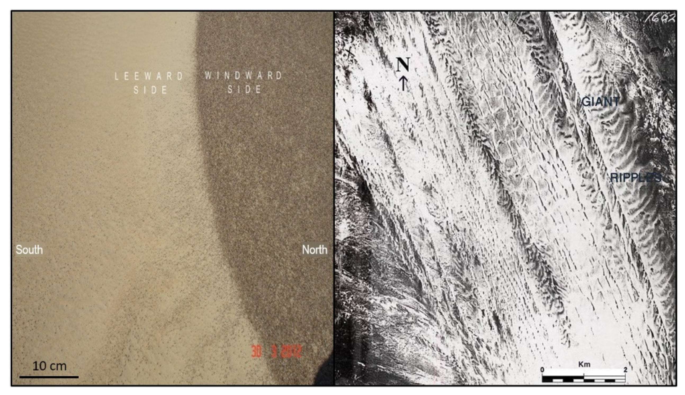
Barchans appear along the western and southern margins of the ‘Erg Body’. Their number and density increase gradually to the southern limit of this section. Barchan chains are organized into two size groups: small and relatively large barchans. Morphologic features suggest that the large ones are older than the smaller dunes in which the eastern horns are longer than the western ones. Some of the long horns are connected to form small linear dunes, as noticed by Bagnold [19] and verified by in the United Arab Emirates [23] and Egypt [49]. This transformation occurs also in Wadi El Rayan Dune Field west of the Nile Valley. Interdune areas of the primary chain of the “Erg Body” are occupied by rows of transverse forms, appearing on aerial photographs, Landsat TM, and Google Earth images as sand giant waves with faces towards the north and lengths of 0.25–0.50 km. In some localities, these megaripples are overridden by some linear dunes, indicating two different periods of formation. The windward side appears darker than the leeward slope (Figure 4). Field investigations confirmed that these transverse forms are giant ripples and that their windward slope is covered with a layer of dark subangular to subrounded very coarse sand [44]. Such forms could have been developed in an earlier period with strong southerly winds.
2.3.3. The Southern Section (Back-Erg)
The southern section of GAM starts on the plateau to the north of Kharga Depression (26° N), and extends southwards into the Kharga Depression and the southern plain to the Egyptian–Sudanese borders (22° N). It is the longest (~450 km) and widest (~50 km at 23°15′ N) section of GAM and is characterized by low dune density and the predominance of barchan, barchanoid forms, and sand sheets. Dunes in this section are organized into chains oriented in an N–S direction. Due to local differences in landforms, relief, and wind regime, barchans are organized into two different patterns: the linear pattern and the protomega barchan pattern. The linear barchans chains are the dominant pattern, and are divided into three groups of which the western one is the largest and widest [50]. As a whole, this western group is composed of barchans and barchanoids, and extends uninterrupted for about 200 km until 24° N. In the southern part, dunes disperse and density decreases, but barchans become larger and complex with several slip faces. The eastern group of barchan chains that run at the feet of the eastern escarpment of the Kharga depression dismantles into several separate small chains due to topographic obstacles. Some of these chains entered some closed small basins, which are filled with excess water coming from the High Dam Lake (Lake Nasser) through Tushka Spillway, and are trapped in these lakes. Protomega crescent belts are composed of numerous, small, closely spaced barchans, arranged in a megabarchanoid shape (Figure 5). They have formed in one locality only in the lee of low escarpments in the extreme south of GAM. This pattern is reported to develop in the desert of the United Arab Emirates [23,51] and the Indian Thar Desert [52]. Their formation is attributed to the effect of a wide unimodal wind regime [52], which seems to prevail in the south of the Western Desert. In the south of the Kharga Depression and in the southern plain, coarse sand that was disintegrated from exposed sandstone bedrock covers the surface beneath the dunes and builds a sand sheet. In fact, this sand sheet represents the eastern part of the much wider Selima Sand Sheet.
2.3.4. Sand Properties
The dunes of the three sections of GAM comprise mainly medium to fine sands (0.125–0.250 mm, 2–3 Φ), skewed towards fine sand. Mean size (MZ) lies between 2–2.15 Φ, in agreement with the global main dune-sand fraction [20]. The grain size in the GAM dunes is unimodal, sorting varies between well to moderately sorted. Samples with coarse sand (1–2 mm, −1–0 Φ) were found in the southern and in the northern section. Such samples represent the sand sheets, which predominate and cover wide areas in the southern plain, where the grain size distribution is bimodal, with a low peak for the coarse fraction. The windward slope of the megaripples rows along the main dune belt of GAM body are composed of coarse sands, ~88% have MZ of 1–2 mm (−1–0 Φ, [44]).
Micromorphological surface features of the dune sands reflect the effect of processes of recent and palaeoenvironments [25,44,46]. Recent mechanical features, mainly saltation impact fractures, striations and breakages due to collision are usually superimposed on surface features formed earlier. Palaeo-mechanical features include linear ridges, small and large depressions, and upturned plates. Chemical features on the most commonly appearing quartz grains comprise triangular solution pits, large deep depressions, and linear depressions, reflecting a complex history of environmental change [11]. Other light minerals are minor constituents, mostly feldspars. In Kharga, quartz is commonly mono-crystalline with minor poly-crystalline grains [25]. The predominance of mono-crystalline quartz indicates multicycling, whereby most polycrystalline quartz and rock fragments were eliminated during transportation, due to their lower stability. Heavy minerals of dune sands comprise opaque (ilmenite, magnetite, and hematite) and nonopaque minerals. The percentage of opaque minerals in the Erg Body is lower (48.7%) than that in the Southern Section (76%), mainly due to local additions from surrounding bedrocks. Nonopaque minerals are varied, ultrastable zircon, tourmaline, and rutile (ZTR) being significant, indicating the maturity of recycled sediments. The total percentage of ZTR minerals of the Erg Body is lower than that of the Southern Section, indicating that the sands of the Erg Body are less mature. Another significant nonopaque is epidote. Its percentage in the Erg Body is more than three times (36.8%) that of the “Southern Section” (10%). Epidote originates in metamorphic rocks. In the GAM, epidote originated in metamorphic rocks of the Eastern Desert, recycled in fluvial sediments of an Oligo-Miocene, pre-Nile drainage system on the Eocene plateau [53]. Preponderance of epidote in the Erg Body is due to proximity of the Neogene source sediments [44].
2.3.5. Dune Displacement
Dune displacement has been studied in the Southern Section of GAM (Kharga Depression) since the early years of the twentieth century [26]. Embabi [54] and, later on, Embabi [55], Stokes et al. [56] and Hassen an El-Leithy [57] (Kharga and plateau), and Embabi et al. [44] (plateau), carried out field measurement. It was concluded that the annual rate of barchan advance in Kharga is 9.0–9.9 m. It was also found that the rate of advancement on the plateau (the Central Section of GAM) is much lower (4.0–5.8 m per year), suggesting a weaker wind environment there. This is confirmed by wind data of the Bahariya station that represent the central section and the Kharga Station, representing the southern section. Bahariya has a low-energy, Kharga an intermediate-energy wind environment according to the classification of Fryberger [5]. In addition, Embabi et al. [44] found that there is an eastward shift as dunes advance southwards on the plateau surface, due to the effect of recent westerly winds. This is supported by the fact that some barchans developed longer eastern horns than the western ones.
2.4. The South Qattara Sand Sea
The South Qattara Sand Sea (~10,400 km2) lies at the southern margins of the Qattara Depression (Figure 2). There have been no detailed studies of this sand sea until recently. However, it was described in some previous studies, depending mainly on Landsat TM images and aerial photographs [8,9,10]. At present, high-resolution images from Google Earth provided an excellent tool for the analysis of the characteristics of dune forms and types (Figure 3e). The sand sea extends for ~200 km in E-W direction from El Bahrain Lake to Al Ghard Al Kabir. Its width varies between 10 km and 150 km. This irregular shape is due to the roughness of the predune surface, resulting in a variety of forms and patterns of changing trends, making the South Qattara Sand Sea one of the most complex sand seas in Egypt. However, it can be divided into an eastern division following an NW-SE trend, and a western one with E-W trend. Both are connected by a saddle of dunes. The eastern division is dominated by linear forms, with local changes in pattern and trend, and has three sections. The northern section lies in a semiclosed local depression, since it is bounded by escarpments from all direction except from the south. It shows two different types of dunes: First the “El-Ghorood El Sooda”, which means the “black dunes” because of its high content of black shale fragments derived from the Oligocene Dabaa Formation [58,59]. They cover the western area (70 km E-W and 40 km N-S) of the basin in a parallel pattern with low density and comprise some compound dunes with a branching pattern and a general NW-SE trend. Some of these branching dunes starts in the leeward side of the northern escarpment, and extend southwards till the southern peripheries of the basin. All dunes are simple narrow ridges, except for one of them which is wider (2.0 km). However, dunes do not have continuous crest lines. On the contrary, they are composed of numerous units of different shapes that coalesce together. Dune length varies between several tens to a few kilometers. Interdune areas of El Ghorood El Sooda are also black, indicating that the shale fragments are either mixed with all sands in this basin, or are spread all-over the surface [10]. This problem needs field investigation to be solved. The second type of dunes occupies the eastern part of this northern basin. It is composed of one bundle of linear branching dunes, 15–45 km long, 2 km wide, with a NW–SE trend and rippled surfaces. At their downwind margins, they dismantle into star and domal/crescentic dunes, also with rippled surfaces (Figure 3c,d). All dunes converge in a curved pattern in the downwind direction, mostly under the effect of the slope of the surface.
At the southern peripheries of El Ghorood El Sooda, dune pattern changes into parallel short sinuous linear with an E-W trend, representing the middle section in the Eastern Division. Dunes here seem to have been developed on an older system of dunes, which appears on images as faint transverse dunes without sharp changes in their slopes. The old system has a very high density since it covers nearly the whole surface. On the contrary, the top linear (more recent) system is less dense. This middle section merges in the east with the southern section of the Eastern Division of the South Qattara Sand Sea.
In the southern section, also two dune systems can be recognized. A system of linear dunes of various sizes and patterns is superimposed on another dune system of transverse form. The former is characterized by low dune density and seems to be active, with sharp sinuous crests and slopes, and lengths varying between several tens to less than one kilometer. The width is within 100–300 m. Dunes extend in nearly all directions, but NW–SE and E–W directions are dominant. This is probably due to the local wind system, in which the direction changes locally. Branching, parallel, and network patterns can be recognized readily in various localities, suggesting that this surface dune system developed since the beginning of the present arid period (~7–5 ka BP). The lower dune system is very dense and totally covers the surface. Dunes have a transverse form, with smooth slopes and without sharp changes in slope angles. It seems that this dune system was developed in an earlier period of dune formation, most probably during the Last Glacial Period, and their slopes were modified and become smooth during periods of less aridity during the Holocene. At their southern extension, similar dunes developed in a linear shape known as Al Ghard El Kebir. This Ghard is ~50 km long and 3–10 km wide. It is a complex of dunes of different forms organized in a dominating linear form. In general, dune density is high in this Ghard, but it decreases at the southern margins due to dismantling into separate linear dunes. A network pattern developed in a low-lying area at the southern margins. This network is joined with a similar pattern developed in the Western Division, where the network pattern prevails over most of it.
The western division of the South Qattara Sand Sea covers only about one third of the total area of the Sand Sea and has an irregular shape, since sand is deposited in various local basins of variable shapes. It extends in a nearly E–W direction to the south of the Qattara salt lakes (El Bahrain, Neweimsa, and Sitra) and starts with two arms, of which the northern one coalesces with the Eastern Division. Although the linear form is predominant, pattern and direction change due to local conditions. It starts in the east with two wide arms separated by a high ground, then after ~25–35 km they unite to the widest patch in this division (40 × 50 km). From here, the dunes extend westwards as a wide (~15 km) belt directly to the south of the lakes of south Qattara till they coalesce with the dunes of the GSS. It seems that this belt lies in a low-lying area which slopes towards the line of the south Qattara lakes and sabkhas. Although the southern boundary is straight, several dunes have a NW trend. Fasulat El Senosi is the largest (30 km long). NW–SE and NE–SW directions prevail. The network pattern is the dominant, which prevails also along the northern peripheries of the GSS, indicating a bidirectional wind regime. Data of the Siwa meteorological station, which is the nearest station at ~200 km to the west, confirms this inference [8].
2.5. The Farafra Sand Sea in Comparison to the Great Sand Sea
In contrast to the Great Sand Sea (GSS), the Farafra Sand Sea (FSS) remained mostly unexplored from a geoscientific point of view. Located between the Dakhla Oasis to the south and the Farafra Oasis to the north (Figure 2), it stretches for about 200 km in a direction of 155° (Table 2) and covers an area of about 17,000 km2. As the southern margin of the FSS lies at roughly 26° N, the geological formations here are younger and belong to the Uppermost Cretaceous and Early Tertiary, mainly consisting of limestones and shales. Although it is very much smaller than the GSS, the FSS has the same appearance with long sand ridges (longitudinal draa with superimposed silk) of similar direction and spacing [13]. The ground elevation is only 100 to 300 m asl because of the basin position, but with a steeper gradient of 1.8‰ to the north. A WNW–ESE running fault in the southern part causes 10 to 20 m-high scarps and hills, but larger obstacles to aeolian modelling are absent. The longitudinal draa of the FSS, also modelled by northerly trade winds in the Pleistocene, show even stronger deviation to the left (155°) than the draa of the eastern GSS (180–165°). This may have been caused by the steeper rise of the underlying surface with increased friction and therefore less Coriolis effects. The draa wavelength is also 2.5–3 km. Even the sand cover of the interdraa corridors north of 26°36′ N is comparable to the eastern GSS. The widths and the heights of the draa, however, with 1.9 km and 30–45 m respectively, are comparable to the western GSS with an ampler sand supply. Five samples of draa sands from two sites have been dated by OSL ([13], AFNL 00017-AFNL 00021 in the dune database [1]). They also show the difference in age between deposits on western and eastern flanks, but in both cases the ages are older than at comparable depths in the GSS: 28–35 ka on the western slope and around 13 ka on the eastern slope. This does not mean that the draa of the FSS are older. From the granulometry of the sand samples, especially from the granulometric sand types [60], it had already been inferred that during accumulation the deflation was stronger than in the GSS. This becomes even more obvious, if the net accumulation rate is calculated. Whereas for the longitudinal draa of the GSS this rate was 110–150 cm/ka [20], the FSS yields only 14 cm/ka [13]. But also here, the extratropical westerlies were effective at the end of the Pleistocene. Thus, the longitudinal draa of the GSS and of the FSS have the same history and both experienced the same shift in palaeowind systems. There are, however, indications that the palaeowinds were stronger in the east. In the GSS, only the eastern part shows a considerable progression of dunes south of the Pleistocene draa. These silks are extending 60 km farther south, and single barchans move ahead. From their rates of migration and from the extension of the silk dunes it was concluded, that barchan migration at least temporarily was involved in this progression so far within a few thousand years [20,27,31].
A similar progression of 50 km to the south has taken place in the FSS where—contrary to the GSS—the change from draa to dunes can even be detected on satellite imagery [13]. This is due to the fact that here transverse barchanoid dunes are predominant which start near the scarps caused by the tectonic fault around 26°20′ N. The southernmost dunes are huge isolated barchans at 25°50′ N. They are very conspicuous because they are even wider than the draa, and some of them are higher (50–70 m). Among the transverse ridges also small silks, chaotic patterns and deep pits are found. The latter indicate the absence of underlying draa. In fact, the bulk of the Farafra sands seem to sit in the modern dunes to the south. However, it cannot entirely be excluded that smaller draa are hidden beneath the dunes [13]. The co-existence of transverse and longitudinal dunes in these ridges under a bimodal wind system resembles the pattern in the southwestern GSS, which was explained by the abundant supply of fine-grained sands [20]. This could be also the reason here because, according to the granulometry, the draa sands farther north are deprived of their original main fraction (sorting of surface sands is much poorer than in the GSS). On the other hand, the mean grain size of dune sands in the FSS is coarser (MZ = 0.2545 mm) and comes closer to the mean grain size of the draa (MZ = 0.3228 mm) than everywhere in the GSS (Table 2). This would mean that also today stronger winds are blowing in the FSS, which is corroborated by the piled-up sands in the south. Besides, the actually blown sands on the eastern slope of the draa also indicate stronger (westerly) winds, because, contrary to the GSS, their depth exceeds 2 m [13]. Similar to the GSS the following landscape evolution is suggested for the FSS: During the Pleistocene (>20 ka BP) longitudinal draa were modelled by strong trade winds in a hyperarid climate. At the end of the Pleistocene (~10 ka cal BP), dry extra-tropical westerlies pushed farther south and deposited sands on the eastern slopes of the draa. During the Holocene humid phase, the draa were shaped into the present whalebacks by fluvial (and aeolian) erosion. At the end of the humid phase (7–5 ka cal BP), the climate became hyper-arid again, leading to the reactivation of draa sands and the formation of the modern dunes.
2.6. The North Sinai Sand Sea
The North Sinai Sand Sea (NSSS, ~13,600 km2) extends over ~120 km from the eastern borders of Egypt to the Suez Canal in the west, and 30–120 km from the Mediterranean coast in the north to the southern slopes of Gabal Um Khisheib, Gabal Maghara, and Gabal Halal in the south. In fact, the Canal separates the western extension lying at present in the eastern margins of the Nile Delta Plain, from the main body of the Sand Sea in Sinai. This Sand Sea extends across the eastern borders to the Negev Desert [61,62]. Directly, east of the Canal, the dunes extend southwards to the latitude of Suez City. According to type, form, pattern, and orientation of the dunes, this sand sea can be divided into two divisions: Firstly, the northern part with dominant linear and transverse dunes, which are oriented in a nearly E–W direction. Coastal dunes along the coastal strip from the Bardawil Lake to Rafah at the northeastern borders represent a distinguished type. Secondly, the area to the east of the Bitter Lakes where parallel N-S compound linear dunes and barchans of various sizes and orientations are developed. This field extends southwards down to the latitude of Suez City. Boundaries between these two divisions are gradual. However, variations in type, form, and pattern of dunes can be recognized. Although numerous detailed studies exist, the NSSS has not been covered by a single comprehensive study. Therefore it will be described in more detail. Previous work covered dune morphology and formation, dune movement and dynamics, sand properties, and controlling factors (wind regime, local relief etc.), e.g., [14,63,64,65,66,67,68,69,70,71,72,73,74,75,76,77,78,79].
2.6.1. Dune Types, Forms, Patterns, and Dynamics in Comparison
The NSSS comprises fixed dunes and active dunes. Although some fixed dunes can be recognized on large-scale maps (1:5000) and aerial photographs (1:10,000) most of them are modified and dissected due to exposure to erosion by wind and water. They are vegetated and appear on aerial photographs as faint forms with flattened crests, while they are represented by contour lines on detailed topographic maps. Forms are linear and barchans dunes, which can be classified into two groups: continental fixed dunes, and drowned dunes. The first are fixed and spread all over the NSSS. Most of them are exposed on the surface, are partially vegetated and were developed during Late Pleistocene [7,75]. Active dunes overlie a relatively small percentage of them. In addition, there are some other fixed dunes on the surfaces of the coastal sabkhas, representing the high sections of lower dunes that are covered and drowned completely by sea water due to rise of the Mediterranean sea level (after 7–5 ka [62,80]). Most probable this submergence happened after the stabilization of dunes by cementation during the Holocene Humid Phase [49,81]. Therefore, it can be inferred that there is an extension of the NSSS into Bardawil Lake, and most probably into the Mediterranean.
Active dunes are composed of loose sand. Due to removal and deposition of sand they grow and, in some instances, move in the downwind direction. They developed mainly atop fixed dunes but do not cover their whole surfaces. Therefore, it can be inferred that the sand of active dunes is mostly originated from the fixed dunes. They can be divided into two subtypes. Firstly, there are continental active dunes, which are spread all-over the NSSS, except for the coastal dune strip. They take several forms of which the linear form is the dominant. Other forms are barchans, transverse, and lee dunes. Secondly, coastal dunes which are present in a zone parallel to the shoreline in a narrow strip up to 6 km wide, which extends from the eastern margin of Bardawil Lagoon to Tel Aviv [79], and in the sand barrier which separates Bardawil Lagoon from the Mediterranean, especially in the locality known as El-Qals, where one of the dunes rises up to 44 m asl. From human remains it was concluded that aeolian sand started to encroach on the coastal plain of Sinai between 7–9th Century AD [79]. Although dune orientation differs greatly from one locality to another, four main trends can be recognized due to the seasonal and local wind systems: N–S, E–W, NE–SW and NW–SE. Dune length varies between 45 m and ~25 km, dune width between eight and 800 m, and height between 2.4 and 64.8 m. Except for the relatively high heights and lengths of some dunes, most of the linear dunes are relatively small in comparison to other sand seas in Egypt [9]. This is probably due to the fact that the active dunes are the most recent dune system in NSSS that developed with the onset of the present arid climate around (~7–5 ka). This relatively recent age did not allow linear dunes to grow and/or coalesce to develop longer ones. There is a weak positive relationship between the dimensions of linear dunes [70]. This indicates that the parameters of linear dunes do not grow at a similar rate like those of barchans [9,82], due to local factors. Table 3 summarizes the data and shows that the dimensions of the barchans of Sinai do not differ from other normal barchans [83].
Linear dunes are organized differently. Spacing and angles are the critical aspects that govern their pattern. Examination of topographic maps, aerial photographs and space images revealed five patterns: straight parallel, curved parallel, braided flat-topped, branching (Y-junction), and network. Since the grain sizes of the dune sands in Sinai vary between normally medium and fine, the wind (direction and velocity) represents the most effective factor. Active (dynamic) dunes are exposed to winds that change seasonally in direction and velocity, resulting in changes in the rate of both sand removals from one side and deposition on the other side (lateral shift). Growth of dunes, elongation of linear dunes and movement of barchans are the main consequences [64,68,72,77]. Tsoar [77] and Tsoar and Yaloon [84] confirmed that the development of linear dunes occurs under bidirectional wind regimes. In sum, linear dunes elongate in the downwind and the cross section changes. Table 4 summarizes the results of four studies on the annual rate of elongation of some linear dunes in various localities. Variations in the rate of elongation were attributed partially to the rate of sand movement along the lee flanks, which depends on the angle of incidence between the wind direction and the crest line [77]. Most of the sand is deposited on the leeside, nearly perpendicular to the crest line. Recent measurements revealed removal and deposition on both sides of the dunes [68,72]. However, lateral shift of the dune body is nearly negligible. Changes in slope form can be noticed during spring and summer months under the effect of relatively strong winds from southwest and northeast [72].

Table 3.
Crescent dune dimensions in the North Sinai Sand Sea.
| Locality | Length (m) | Width * (m) | Height (m) | Eastern Horn (m) | Western Horn (m) | Orientation |
|---|---|---|---|---|---|---|
| West Wadi El-Arish 1 | 142.6 | 256 | 16.3 | 119 | 234 | 305° |
| Various Areas 2 | 137.4 | 133 | 12.4 | Average = 105.8 | - | |
| Wadi El–Masagid 3 | 36.7 | 49 | 4.2 | - | - | - |
| The Mediterranean Coastal Plain 4 | - | - | 2.5–25.5 | - | - | - |
| South Gabal El Magharah 5 | 43.2 | 40.8 | 2.5–7.5 | 11.2 | 9.5 | 74.5° |
Crescent dune movement was measured in the field on three small samples in different localities: on four dunes (one year) in the region of El-Arish City [75], on five dunes (June 2001–June 2002) in the region to the east of Suez Canal [64], and on seven dunes along the coastal plain during the period 12 November 1981–15 August 1982 [85]. In addition, two series of satellite images (1984–2001) were investigated in the region to the east of Suez Canal [64]. Table 5 summarizes the results. It shows that, in spite of the small size of the four samples and the short period of field measurements (one year), there are significant variations in dune advance. These can be interpreted by differences in dune size [75]. Table 5 also shows that most of the movement occurs in winter, especially in the coastal area of El-Arish City. However, there are some differences. In the El-Arish region, dunes move eastwards [75], whereas in the region to the east of Suez Canal, barchans advance in the southeast direction [64]. These differences can be interpreted by regional and seasonal variations in wind direction. Tsoar [75] found that the magnitude of the summer northerlies increases and a southward movement of sand is noticeable. In addition Akl [64] studied the displacement of 32 barchans 1984–2001. He found that barchans move southwards and eastwards, indicating that they are exposed to two effective wind directions: NW and N. Higher annual average shift towards the east (4.6 m) than that towards the south (3.9 m) show that the northwestern winds are stronger and more frequent than the northern winds. It was also noticed that small dunes became larger during their movement. This means that sand deposition overweighed sand removal on these dunes, and that there is a continuous sand supply from the northern upwind region. El-Kayali [85] measured the height of seven dunes is November 1981 and in August 1982. She found, in accordance with Akl [64] that all dunes increased in height by 0.8–1.4 m during this period.
In an attempt to investigate the changes that occur on morphology of barchan dunes, a field survey was carried out on five dunes situated to the east of Suez Canal [64]. Measurements by a geodetic total station revealed that all dunes grew in size from June 2001 to June 2002. The eastern horns grew at a greater rate than the western ones under the effect of the strong NW wind and seasonal changes in the position of the dune crests, especially in winter due to the effect of a reverse wind that comes from the south.
2.6.2. Physical and Mineralogical Aspects of Dune Sands in North Sinai
Sinai sands vary in their grain sizes between medium and fine factions (Table 6). Local differences can be explained by variations in the source region. Standard deviation indicates that in most areas the sands are moderately sorted (So = 0.5–1.0). Well and very well sorted sands (So < 0.50) are present in areas where samples are composed of fine sand, whereas poorly sorted samples (So > 1.0) can be seen in coarse sand. These characteristics are similar to those found in other sand seas in Egypt [9], indicating that the sands of the NSSS reached the mature stage. There are some differences in the grain size composition between different forms and between the various parts of dunes [67,72,73]. The amount of coarse sands is higher in sand sheets (18.1–35.5%) and sand ripples (33.87–46.5%) than in sand dunes (1.61–7.9%). Coarse sand grains are necessary for the development of sand sheets and ripples and protect the underneath sand layers. Finer grains are removed. In the meantime, dune windward sides are coarser than dune crests and leeward sides.
Most of the sand grains of the NSSS are composed of light minerals, of which quartz constitutes 90–97%. Heavy mineral percentage is found to be higher (7.2%) in the sands of coastal dunes than in those (2.4%) of continental dunes [75]. Nearly all heavy minerals are present in all localities, but with different percentages due to changes in the sand source. Khidr [72] revealed one of the significant findings which is the abundance of epidote in nearly all analyzed samples collected from the area to the west of Wadi El- Arish (53.39% out of the all nonopaque minerals). El-Banna [68] also found high amounts of epidote (30.86% in average). In the coastal strip around Bardawil Lake, epidote has smaller amounts (15.7% [66], 16.5% [71] in average). Metamorphic and sedimentary rocks as potential sources are not present in the nearby areas, but in the far south in Sinai, or in the Red Sea Mountains and in the Nubian Sandstone in Southern Egypt. This means that the source of epidote is external. A study of the minerals of the dunes of northern Sinai [73] concluded from the distribution of pattern of heavy minerals that the possible sources of the sands of the area between Risan Aineiza and El-Arish and the area east El-Qantara-El-Shatt are igneous and metamorphic rocks, whereas in the area between El-Arish and El-Tina Bay sands are derived from several sources, i.e., Nubian Sandstone, metamorphic rocks, and pre-existing sediments. According to Khidr [72], the mineralogical analysis of sand samples (N = 28) revealed the presence of hypersthene in low percentages, which is one of the heavy minerals in the Nile sediments in Egypt [86]. Also, augite was found in most samples in very low percentages [68,72]. Its grains have a shape and color similar to those described by Shukri [86] from the recent Nile sediments.
2.6.3. Factors Affecting the Development of the North Sinai Sand Sea
Besides the prevailing wind, other factors like sand supply, climatic changes, sea level oscillations, and the offshore marine current affect the development of the dunes in North Sinai. The wind system is characterized by several aspects [14,68,71,72], after the data of Tsoar [75]:
A Complex wind regime with various directions, durations, and strengths, seasonally and locally.
Higher percentages of effective sand-moving winds (>11 knots/>5.6 m/s) in the western region of North Sinai than the middle and eastern part (Table 7). This indicates that wind energy decreases from west to east.
More frequent effective sand winds during winter and spring than during summer and autumn.
Prevailing NW winds during summer and spring and SW winds during autumn and winter.
Decreasing frequency of effective NW winds eastwards, where they are replaced by the southerly and southwesterly ones.
The coastal offshore current (or East Mediterranean Current) moves eastwards along the Egyptian coasts of the Mediterranean Sea [79]. It transports Nile sediments from the mouths of the present-day Rosetta and Damietta branches and the ancient Nile Branches towards the coasts of Sinai and Gaza. Sand deposited along the beaches is driven inland by northern winds. The sand bulk reaching Sinai beaches decreased drastically after the construction of the High Dam at Aswan, resulting in the deposition of Nile sediments in the basin of Lake Nasser. Climatic changes were responsible for the availability of fluvial sediments in the surroundings of Sinai Sand Sea, from which winds deflated sand necessary for the development of dunes. During the humid periods of the Pleistocene, huge quantities of fluvial materials were laid down in internal basins, flats, wadi beds and fans as indicated on the geological maps of Sinai (e.g., [87]). During the Last Glacial Maximum, sea level dropped by ~100–130 m and the Sinai coastline retreated northward ~50 km. This is suggested to have caused increased aridity and desertification in northern Negev [61] and northern Sinai [62]. As the sea level rose up, the area decreased until it approached its present-day status. The presence of drowned dunes at least in Bardawil Lake confirms this inference.
Aeolian sand is available along the beaches of the northern coasts of Sinai, and in fluvial (particularly from the Nile) playa and sabkha deposits on the mainland. From these sources, winds deflated sands, recycled them, and modeled them into aeolian sand forms [85,88]. The depositional ages of the dunes were discussed in several studies, but no numerical ages are available up to now. It was concluded by Neev et al. [89] that the small erg south of the coastline between El-Arish and the Suez Canal is younger than Late Pleistocene, since the age of the underlying chalky fresh water limestone is approximately 35 ka. In accordance with Roskin et al. [61] and Muhs et al. [62] we can deduce that the initial dune encroachment into the North Sinai took place during the Last Glacial Maximum (comp. also [7,90]).
2.6.4. Hazards Caused by Moving Sand und Dunes in North Sinai
The frequency of sand encroachments increased after human activities in the last three decades [10]. Vast areas are now under reclamation after water was transferred by the El-Salam Canal from the Nile and its canals. Also agricultural projects to the east of the Bitter Lakes started recently. Canals and traffic lines are threatened by sand, especially during periods of high wind velocities. Further studies are planned for measures to protect cultivated land from such threats.
3. Dune Fields
3.1. The North Nile Delta Coastal Dune Field
The North Nile Delta Coastal Dune Field (today ~857 km2) changed drastically under population pressure in the Nile Delta. It has been exposed to intensive land reclamation in the last 30 years, mainly for agricultural purposes. It is concentrated in the central part of the Nile Delta between the Branches of Damietta and Rosetta and is bounded by the Mediterranean in the north and Lake Borollos and the cultivated land in the south. Its dynamic is controlled by the coastal northern margins of the Delta where wetlands of lakes and sabkhas are dominating. Further influences are coming from infiltrated rainwater (winter) and from vegetation growth. Recrystallized salt from seawater spray stabilizes the dune sands. Only the surface layer is mobile during the dry summer. This process of sand movement represents a threat to some villages or palm groves.
Barchans, barchanoids, domal dunes, and linear dunes are the dominant forms in this field. Dunes look as if they are composed of several generations. Recent ones override older dunes, leading to the development of several small slip faces along the windward slopes. This process induces the coalescence of dunes, giving rise to the development of the linear shape 400 m long and 45 m wide [91]. Normally, dunes rise 2–3 m, but occasionally reach 5–6 m, and rarely 9–10 m. Although modest, these heights give the surface a coarse texture. Locally, dunes are called “Elwa” (high ground) or “Kom” (mound), while wet interdune areas are occupied by salt marshes. Fixed old dunes were found to occur south of Lake Idku and underneath the recent dunes at Rosetta, Kom El-Mastoora in the area of El-Borg, Gamasa, and Baltim. Remnants of similar old dunes occur on some of the small islands in El-Borollos and Idko Lagoons. The dunes do not exhibit any specific form. Their surfaces are covered by coarser sand than that of modern dunes with brownish color. The sands resemble the coarse Holocene sands that were met in boreholes at depths of 20 m [92], probably representing a Holocene coastline.
Dune sand is grayish in color due to the presence of a relatively high percentage of black sands. The coastal black sands contain 67% of opaque minerals such magnetite, ilmenite, monazite [93]. These characteristics and the orientation of barchans horns southwards beside the prevailing northern winds indicate that the sands are originated from the fine Nile sediments. The sediments have been cut off since the construction of the High Dam in late sixties of the 20th Century, showing that sand balance at the present time is negative.
3.2. The West Nile Delta Dune Field
The West Nile Delta Dune Field (~4400 km2) appears on the geological map of Egypt [87] as stabilized dunes, which have an E–W maximum length of 160 km and a maximum N–S width of 40 km. It is also called Wadi El-Natrun Dune Field [94], and has an undulating surface and faint forms. On aerial photographs, faint barchans with horns pointing westwards from the Delta margins, crossing the Cairo–Alex highway, passing the northern margins of Wadi El-Natrun and ending at the NE corner of Qattara. The westward orientation of barchans suggests a prevailing easterly winds and the Nile Delta as sand source, since present-day prevailing winds are from the northern directions. According to Kar [53], this dune field overlies the Qena sands (pre-Nile sediments, Middle Pleistocene). The dunes of the West Delta Field were exposed to extensive land reclamation and cultivation during the last four decades, especially in areas nearer to the delta. Only a few bare areas can be seen along the Cairo–Alex highway. It is recommended that this field should be studied in detail so that source of sand and age can be determined accurately.
3.3. The East and Southeast Qattara Dune Field
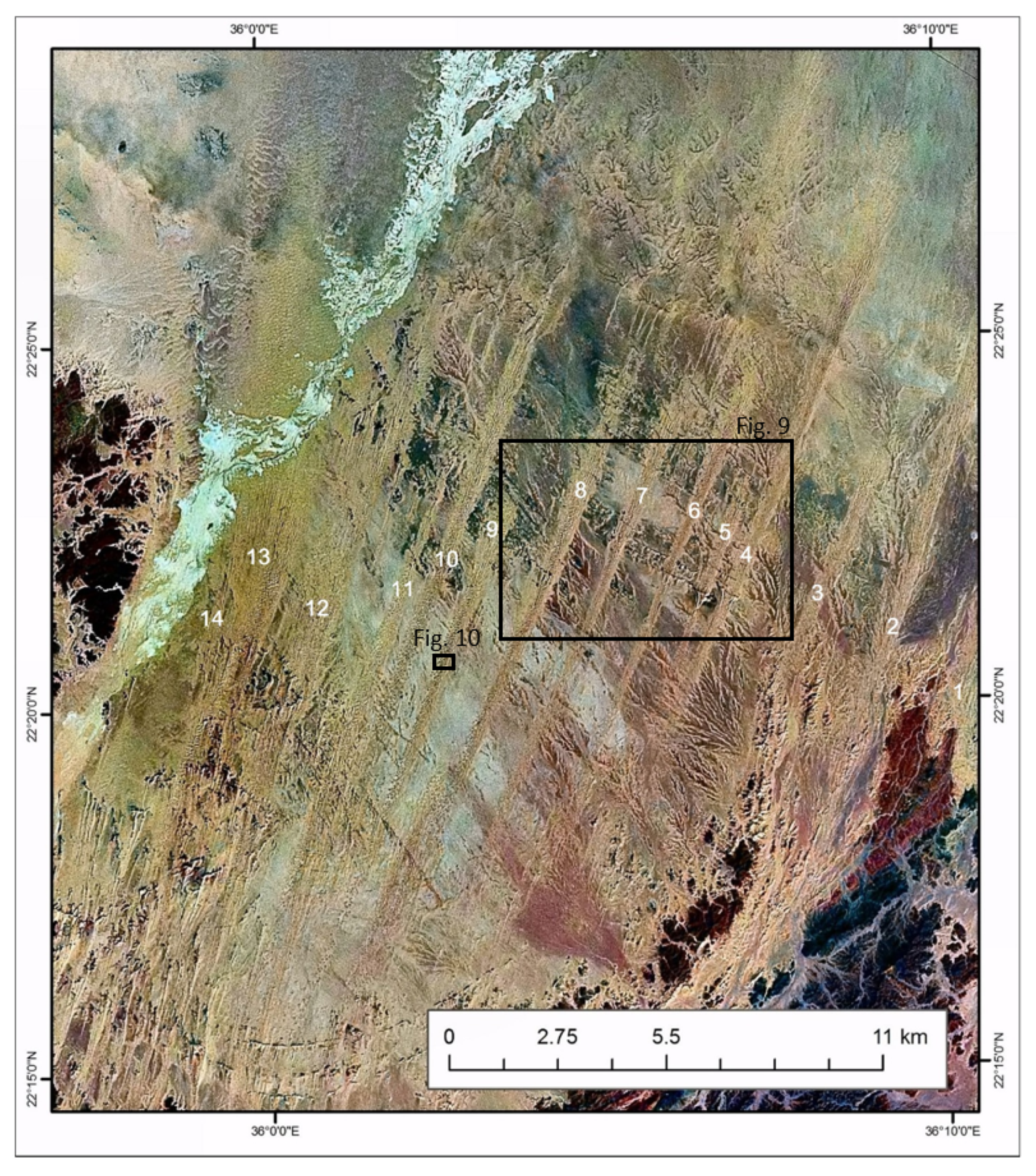
The East and Southeast Qattara Dune Field is the largest in Egypt (28,754 km2, Figure 2, Table 1). However, sand coverage is one of the lowest (21.3%). It was studied by Ali [95] and extends 250 km from E to W, from the NE tip of the Qattara Depression to ~30 km W of Wadi El-Natrun. It also extends 150 km from N to S where some dunes in the E approach the Cairo-Bahariya highway. The topography rises from 15–20 m below sea level in the west to more than 200 m asl, indicating that most of this field lies in Qattara Depression, which is delimited by the 200 asl contour line.
Compound parallel linear dunes prevail which extend in SSE direction. Topographic maps show that all dunes carry names, such as Ghard Abu Sinan, Ghard Ar-Rammak, Ghard Misaa’da, Ghard Abu El-Gharadiq, and Ghard El-Henaishat. This characteristic distinguishes this field from other dune fields in Egypt. Dune lengths vary between 6 and 120 km, widths between 0.4 and 17.4 km, and heights between 18 and 120 m [95]. In general, dunes become wider and more complex westward. The latter are composed of several ridges, which coalesce in an upwind Y-junction, forming in most cases one ridge at the downwind section. However, nearly all dunes in this field are exceptionally wide at their upwind section. They have small barchanoid forms, representing the second dune form in this field. When these areas were examined on topographic maps (scale 1:100,000), it was found that they are located in shallow depressions where they were initiated. As sand accumulation and sand supply continued, dunes grew southwards [95]. In the cross section, sand ridges like those of Farafra and the Great Sand Sea are composed of sharp crests overriding wide plinths or whalebacks. Barchanoid forms developed not only at the upwind sections of linear dunes, but also at their western margins, where sand supply decreases. They vary in size and stage of development from very small (less than a few hundred meters) to more than a kilometer in length and width. Their orientation is towards the west, which is similar to that of the ancient barchans and barchanoid forms of the West Delta Dune Field. On the contrary, the orientation of the linear dune is SSE. This is most probably due to difference in the effective winds on both dune forms. Present-day climatic data show a strong eastern wind vector that might be responsible for the development of barchanoid forms of both West Delta Field and E and SE Qattara Field, suggesting, since the horns are pointing westward, that these dunes were developed under a past wind regime with a strong eastern vector. According to this hypothesis, the source of sand for the barchanoid forms of E and SE Qattara Field could be the Qena sediments of the Nile Delta, which underlie the West Delta Field [53]. Also the linear dunes might be generated from this source. In this respect, the whole dune field of E and SE Qattara can be divided into two divisions according to the origin of the sand: a western division, where the source of sand is the Qattara Depression, and an eastern division in which the Qena sediments of the Nile Delta are the sources.
3.4. The Wadi El-Rayan Dune Field
The Wadi El-Rayan Dune Field (~1200 km2) extends longitudinal from the central part of the depression of Wadi El-Rayan in the north (29°11′ N) to the western margins of the Nile Valley opposite the City of Dayrut in the south (27°30′ N), over a distance of ~185 km [96]. It is composed of several parallel compound and complex dune belts extending in the same SSE direction. Dune forms change from linear ridges in the north to barchans and barchanoid forms in the south. The barchans and barchanoid forms are organized into three parallel belts. In spite of this general orientation, the linear dunes are sinuous due to the bidirectional wind system [96]. Apart from a few, they are concentrated in the eastern part of the Wadi El-Rayan Depression. The barchans of the southern division often show longer eastern horns than western ones, taking the form of linear dunes [96]. Their length varies 0.2–1.2 km, while their orientation varies 133–173° with a mean direction of 158°. Gad [97] concluded that they evolve out of the eastern horns of barchans. This is caused not only by N/NW mean winds, but also by the stormy wind component more from the west. It should be noted that the ground slopes from the west towards the Nile Valley. Thus it is expected that the sand moves preferably downslope.
The Wadi El-Rayan Dune Field represents the third cycle of dune development in this region, which lies to the south of Wadi El-Rayan and to the west of the Nile Valley. In this stretch, aeolian sand and dune remains known as El-Khafoug formation [53], interfinger both the pre-Nile deposits of the Middle Pleistocene and the neo-Nile sediments of the Late Pleistocene [53]. In the southern part, interdune areas of the extreme eastern belt are reclaimed and are cultivated during the last four decades. However, dune movement and sand encroachment on the cultivated fields along the margins of the flood plain are a permanent threat to soil productivity and agricultural production [98].
3.5. The North Uweinat Dune Field
The North Uweinat Dune Field (~8000 km2) occupies the extreme SW corner of Egypt, from the southern margins of the Gilf El-Kebir Plateau to the northern flanks of Gabal Uweinat. It represents the final sand flow driven off the Great Sand Sea. Its topography is very rough due to the presence of many large blocks of igneous, metamorphic, and sandstone rocks, which represent obstacles to the sand flow. Therefore, many dunes are diverted and converge in the downwind direction. Linear lee dunes extend over several kilometers. The wind regime, shown by the regional dune orientation, is unimodal (NNE–NE), similar to that in the southern part of Selima Sand Sea. It seems that wind direction in the southern part of Egypt is in general from NNE and NE since the orientation of El-Hebal Dunes in the extreme SE corner of Eastern Desert also follow this trend.
3.6. The El-Khanka Dune Field
The triangular El-Khanka Dune Field (~80 km2) is situated NE of Cairo in a basin between the Nile Delta and the adjacent desert (Figure 2). The base of the triangle runs for ~9 km in an N–S direction along the cultivated fields of the Delta. The southern side runs for ~13 km in an E–W direction, bounded by the bed of Wadi-Hamra, while the third side of the triangle is irregular due to local relief and extends for ~15 km. It is also known as Gabal El-Asfar (yellow) dunes [99]. Sediments were studied by Philip and Beheiry [100] and Kholeif et al. [101]. Topographic maps show that this field occupies a basin known as “Heliopolis Basin” where wadis (El-Forn, El-A’nqabia, and El-Diba) terminate. The ground gets higher to the N, E, and S of the dunes. According to Beheiry [99] the Khanka Dunes cover the dissected gravelly-sandy surface of the compound local fans formed by the wadis.
Compound and sinuous linear dunes, organized in a parallel pattern, are dominating. The orientation of the dune ridges changes from nearly N–S in the western and northern parts to NW–SE in the southern and eastern parts. In the extreme eastern part the dunes become very complex due to the coalescence of several ridges. Dune length varies between 100 m and 1500 m, width between 20 m and 150 m. The cross-section of the ridges are asymmetrical, but without any general orientation. Its highest point is 176.7 m asl. Taking the nearest lowest point (89.2 m asl), the maximum height of dunes is 87.5 m, while the lowest height is 5 m. However, height increases from N to S and from W to E. In some localities, dune ridges coalesce circularly so that the low interdune areas are basin-like.
The analysis of the wind regime of El-Khanka Meteorological Station by Beheiry [99] showed that the wind is multidirectional, with a relatively high percentage of occurrences from the N, NE, NW, E and SE. This explains the change in dune orientation and the asymmetry in dune cross section. Basins at the margins of the Nile Delta were ideal localities for sand accumulation and the development of dunes. The huge quantities of fluvial sediments either from the Delta or from wadi deposits were the sources [99]. El-Khanka Dune Field has been modified severely due to recent land reclamation for various purposes such as new towns, industrial areas and highways.
3.7. El-Hebal Dune Field
The El-Hebal Dune Field is developed in the remote SE corner of the Eastern Desert. It is one of four dune fields in this region. They were called collectively in a previous work “El-Hebal Dune fields”, since the field of El-Hebal is the only one which carries a local name. Till recently, only two fields were known [9], but due to the availability of high-resolution satellite images, a small third field of fixed barchans and barchanoid forms was discovered on the Delta of Wadi Kraf. The field was first mentioned by Ball [102]. El-Hebal (“the ropes”) is a local name for the dunes that lies at a few kilometers to the S of the Delta of Wadi Kraf, while the second field lies to the west of Wadi Kraf, where the dunes are intruding the foot slopes of the Red Sea Mountains from the NE. Since it lies to the west of El-Hebal Field, it is called here “West El-Hebal Dune Field”. The third field is overriding the northern part of the Delta of Wadi Kraf (Figure 6). The fourth dune field is discovered while examining Google Earth images of this part of the Eastern Desert, and first mentioned by Embabi [10]. It is called “Wadi El-Allaqi Dune Field” because it starts just to the south of the central section of this wadi in Egypt (Figure 7). It extends into the Sudan for several kilometers.
Covering an area of ~400 km2, the dune lines of the El-Hebal Dune Field developed on the bahada plain and the foot hills of Red Sea Mountains. The plain rises gradually from about 50 m asl at the upwind section of dunes to about 300–350 m asl at the downwind section. The dune field starts at ~20 km from the coastline and extends inland for ~25 km. Drainage lines start braiding at the foothills, where they are cut by the dune ridges. Only a few of these drainage lines cross the bahada plain and reach the coastline, forming deltas such as that of Wadi Kraf. The orientation of the dune lines ranges 20–28°, with a mean of 24° (Table 8), similar to the Uweinat Dune Field and the dune belts of the Southern Plain in the Western Desert. Analysis of wind data of the East Uweinat Meteorological station showed that about 40% of the total wind frequency comes from 14–44° [49]. Therefore, it can be said—in the absence of wind data for the region of El-Hebal Dunes—that the orientation of the dune lines in the El-Hebal Field can be explained by a similar wind regime. It is composed mainly of 14 longitudinal units with relatively short lengths that varying between 3.2 km and 18.7 km (average of 10 km, s. Figure 8). They have relatively wide breadth, ranging between 0.3 km and 0.8 km, with an average of 0.49 km, and are composed of three dune forms: linear, barchans and transverse. Linear dunes and transverse are developed along the main body of each unit, while the barchans are formed along the downwind section. In interdune areas between the main units, short lee dunes (0.2–1.0 km) have developed in the leeward side of low-lying ridges (mostly dykes) that extend at right angles to the dominant wind direction.
El-Hebal linear dunes are unique in their morphology and mode of development. It was found that they are composed of several coalesced lee dunes which developed in the lee side of the low sandstone ridges formed at right angles to the prevailing wind direction. These lee dunes extended southwards by time and coalesces forming larger linear dunes. Therefore, the growth and unification of lee dunes resulted in long units of linear dunes [10]. The development of several lee dunes beside each other in the leeside of ridges gave El-Hebal another morphologic characteristics, which is that they are grouped into bundles of three to four parallel linear ridges (Figure 9). Due to a decrease in sand supply, the linear shape dismantled and disappeared, and transformed into barchans.
Barchans are clustered at the downwind sections of the linear dunes. They have lengths and widths of a few hundred meters. Many of them do not have slip faces, while others have small, short ones. Most of those barchans, which do not acquire slip faces, did not develop horns; only those with slip faces have very short horns (Figure 10). Their windward slopes are characterized by low angles, and they are symmetrical in all directions. The surface of the windward side of all barchans are relatively dark, which is mostly due to the presence of a higher content of heavy minerals, under the selection of wind action and the removal of lighter grains. Due to the presence of this surface layer of heavy grain atop the surfaces of barchans, it should be expected that their rate of movement is relatively low. Their rate of movement is also decelerated because the surface of the ground is getting higher in the downwind direction, resulting in a resistance to the sand moving winds.
3.8. The West El-Hebal Dune Field
The West El-Hebal Dune Field (~350 km2) intrudes farther into the foothills of the Red Sea Mountains. Here, the ground rises up from 140–150 m asl on the bahada plain to 350–400 m asl [comp. 10]. Therefore, it is developed on a rough surface with numerous small hills. This is why almost all dunes are lee dunes. It has an irregular shape, with a maximum length of ~26 km from north to south, and a decreasing E-W breadth ~22 km in the upwind section to 4–5 km in the downwind section. Lee dunes are generally short and mostly do not exceed several hundred meters. However, some of them reach 2–10 km. Their orientation is NNE (20–25°) similar to that one of the El-Hebal Dunes. Transverse dunes are common in the northern part of the field where the surface of the ground is not rough. Climbing dunes on wadi sides and mountain slopes occur where orientation of wadis and slopes is favorable for their development.
3.9. The Delta Wadi Kraf Dune Field
The Delta Wadi Kraf Dune Field (~150 km2) differs from the previous ones in two aspects. It is composed of barchans and barchanoids, and the dunes are vegetated and fixed. It has a maximum E-W length of ~18 km and a maximum N-S breadth of ~12 km at the lower section. The deltaic plain rises gradually from 5–10 m asl near the Red Sea coast to 40–45 m asl at the inland extension of the dune field. Apart from the dunes, this plain is covered by a sand sheet. There are five dune forms in this field: crescentic, barchanoid, linear, lee, and nebkhas. Lee dunes are the only active forms. They developed in the leeside of other dunes in the downwind section of the field and are generally small with a length of 100–200 m in general and 300–400 m in rare instances. Barchanoids spread more than barchans in this dune field. Most barchanoids are coalesced, forming curved rows parallel to each other with a general orientation of NNE-SSW. In some cases, barchanoid ridges look like linear dunes, especially those with sharp crests. Heights of barchans, barchanoids, and linear dunes do not exceed a few meters. This is because slip faces of some forms are short and fixed dunes are exposed to sand removal by wind resulting in the reduction of their heights. Although nebkhas are tiny forms, they are the most widespread because of the often small vegetation shrubs. Small dunes have developed here, often with a short tail.
3.10. The Wadi El-Allaqi Dune Field
The Wadi El-Allaqi Dune Field is given its name from its location just to the south of the central section of Wadi El-Allaqi (Figure 7). It was discovered through the visual examination of Google Earth in 2015 [10]. It has an irregular shape, with a maximum E–W length of ~26 km, a maximum N–S extension of ~21 km, and an area of ~500 km2.
Nearly all dune forms are present in this small field. Simple and compound linear are present in various parts. The largest linear dune extends for about 9 km. All large linear dunes are sinuous and compound of several parallel and branching ridges. Lee dunes also developed in this field due to the wide spread of vegetation and rocky obstacles. Barchans and barchanoid forms are the third characteristic forms. Barchans are less frequent because of the roughness of the topography. They are characterized by three aspects. Firstly, they are small, where length and width do not exceed 40 m with low-angle surfaces. Secondly, most of them do not have slip faces or they have very short ones. Thirdly, they developed very short lee dunes. It can be inferred from these characteristics that these barchans are still in their early stage of development.
3.11. Sand Properties in the Southeastern Part of the Eastern Desert
Due to its location and security restrictions, it is hard to undertake detailed scientific fieldwork on dune fields in the remote area of southeastern part of the Eastern Desert. This is why only two preliminary studies were carried out [9,103]. The results of the first study were published, whereas those of the second one are not yet. The first study depends on four samples only, three from a linear dune and the fourth from the beach of Delta Wadi Kraf. Though small, mineral composition is carried out beside the grain size analysis. The second study depends on grain size analysis only of ~70 dune samples (linear, barchans and lee dunes). A synopsis will be given in the following section on the major aspects of the grain size and minerals of the sands of El-Hebal dunes, depending on the results of these two previous studies.
The analysis of the grain size samples showed that sand grains of the El-Hebal dunes ranges between fine and very fine or between medium and fine [9,103]. Most probably, these variations in sand grain size are due to local sand supply from the surrounding areas, especially the underneath is composed of fluvial sediments derived by water flow from the mountains during fluvial periods. The study of Embabi [9] revealed that sorting of all samples is very good, except for the beach sample, which is good. Sorting becomes poor as the sand gets either finer or coarser, comp. [9,22]. This is the case of Wadi Kraf beach sands, whose sorting is poorer than other samples, because it contains a much higher percentage of medium size sand fraction than others.
Table 9 shows that the majority of samples are composed of nonopaque mineral, except for the beach sample where these minerals compose one third of it. On the contrary, the opaque minerals form the majority of the beach sample. Table 9 also shows that the percentage of the stable ZTR minerals in the dune samples is much lower than that of the beach sample, which indicates that the sands passed few cycles of deposition. Consequently the dunes are relatively recent [9].
4. Conclusions
The study at hand summarizes, following the studies of about the sand seas [8,10,11,13], the recent knowledge about all sand accumulations of Egypt. It considers also recent studies written in Arabic. Measurements on available maps, aerial photographs, and (high resolution) satellite images enable to quantify the dune and sand coverage. More than one quarter (28.2%) of Egypt’s surface (1,001,450 km2) is taken up by sand seas (23.8%) and dune fields (4.4%). Whereas the six sand seas are sand covered on average by 74.8%, the ten identified dune fields have an average sand cover of only 31.7%. Nearly all dune forms can be found in Egypt. However, longitudinal and barchanoid dunes prevail. In the meantime, another two forms were discovered very recently. The first is the star dunes in the extreme northern part of the Great Sand Sea and in the southern margins of the South Qattara Sand Sea [10]. The presence of this form is evidence that the wind regime in the NW of Egypt is multidirectional. The second form is the giant ripples of Ghard Abu Moharik, which developed in the Central Section of this sand sea. These ripples are organized in rows parallel to the main trend of linear dunes, with northwards faces contrary to the normal trend of the faces of other forms (e.g., barchans) [44]. In some instances, these giant ripples are covered with linear dunes. These characteristic and the composition of these giant ripples of very coarse, very hard, and dark epidote grains is an evidence that the recent S and SSE winds are very strong. Further investigations are needed to know original trend of the southern wind and age of ripple development.
The Egyptian sand accumulations, although distributed all over the country, are unequally distributed among the four major regions. This fact does not apply on the number of sand seas and dune fields only, but also on the total area of the sand cover. The distribution is correlated with pre-dune topography, where dune accumulations occur in low-lying topographic areas, comp. [4]. With regard to the recent winds, significant aeolian sand deposits are situated in today’s low-energy wind environments [14].
For the Great Sand Sea and for the Farafra Sand Sea, chronological data (OSL) exist [29] and were incorporated in the INQUA (International Union for Quaternary Research) dune database [1]. In combination with additional sedimentological, micromorphological, and geoarchaeological evidence, these data suggest three main phases of aeolian deposition: before and during the Last Glacial Maximum by strong and dry northerly trade winds, during the terminal phase of the Pleistocene by dry westerlies, and after the so-called “Holocene humid optimum phase” by the recent bimodal wind system from the northern direction. Some thermoluminescence data for the Selima Sand Sea [43], located far in the south of Egypt, confirm the results for the Last Glacial Maximum and for recent times but do not show the west-wind phase at the end of the Pleistocene. Therefore the southern part of Egypt (south of approx. 24° N) was and is dominated by northerlies at least since the Last Glacial Maximum.
These results are supported by the results found for the dune fields of Egypt. A comprehensive examination of the other sand seas (Ghard Abu Moharik, South Qattara, and North Sinai) and recent studies from the Negev [61,62] confirm this picture. However, they although most probably originated in the Late Pleistocene, the patterns of the dune fields are lesser organized in comparison to the sand seas. The reasons for this can be found in the lesser sand cover, in lesser sand masses and in the stronger influence of bedrock obstacles and vegetation, which lead to complex patterns, frequent reorganization and therefore to an individual character of each dune field. However, similar to the sand seas, dune fields often show linear pattern at the upwind sections and transverse barchans (as typical sand starving forms) at their downwind sections. Both sand seas and dune fields need further studies and stratified chronologies, not only for a reasonable estimation of future sand mobility in the course of global climate change but also for an evaluation of possible threats to settlements, traffic lines and agricultural land. Parts of the North Sinai Sand Sea, the Farafra Sand Sea, the Abu Moharik and four of the ten dune fields are part of or beside to inhabited regions (in the Western Desert, the Nile Valley, the Nile Delta, and along the Mediterranean coast). As a consequence, they changed drastically due to land reclamation during the last decades. On the other hand, their sands pose a risk for the society. Therefore, further studies concerning sand mobility, local wind systems, and land use are needed.
Author Contributions
Conceptualization, O.B. and N.S.E.; methodology, O.B. and N.S.E.; validation, O.B. and N.S.E.; formal analysis, O.B. and N.S.E.; investigation, O.B., N.S.E. and M.M.A.; resources, O.B., N.S.E. and M.M.A.; data curation, O.B. and N.S.E.; writing—original draft preparation, O.B. and N.S.E.; writing-review and editing, O.B.; visualization, O.B. and N.S.E.; supervision, O.B., N.S.E. and M.M.A.; project administration, O.B., N.S.E. and M.M.A.; funding acquisition, O.B., N.S.E. and M.M.A. All authors have read and agreed to the published version of the manuscript.
Funding
Main results of the study were conducted within the project “Sand Accumulations in Egypt”, funded by the Ain Shams University, Cairo, and within the Collaborative Research Center 389 “Arid Climate, Adaptation and Cultural Innovation in Africa (ACACIA)”, funded by the Deutsche Forschungsgemeinschaft (DFG). The chronological data were integrated in the INQUA Project 0704 “A Global Digital Database und Atlas of Quaternary Dune Fields and Sand Seas”.
Acknowledgments
The authors thank E. Parteli for his invitation to write this review.
Conflicts of Interest
The authors declare no conflict of interest. The funders had no role in the design of the study; in the collection, analyses, or interpretation of data; in the writing of the manuscript, or in the decision to publish the results.
References
- Lancaster, N.; Wolfe, S.; Thomas, D.; Bristow, C.; Bubenzer, O.; Burrough, S.; Duller, G.; Halfen, A.; Hesse, P.; Roskin, J.; et al. The INQUA Dune Atlas chronological database. Quat. Int. 2016, 410, 3–10. [Google Scholar] [CrossRef]
- Haynes, C.V. The Darb El-Ara’in Desert. A product of Quaternary climatic change. In Desert Landforms of Southwest Egypt: A Basis for Comparison with Mars; El Baz, F., Maxwell, T., Eds.; NASA: Washington, DC, USA, 1982; pp. 91–118. [Google Scholar]
- Bagnold, R.A. A further journey through the Libyan Desert. Geogr. J. 1933, 82, 103–129. [Google Scholar] [CrossRef]
- Wilson, I.G. Ergs. Sediment. Geol. 1973, 10, 77–106. [Google Scholar] [CrossRef]
- Fryberger, S.G. Dune forms and wind regime. In A Study of Global Sand Seas; McKee, E.D., Ed.; US Geol. Survey Prof. Paper 1052; US Government Printing Office: Washington, DC, USA, 1979; pp. 137–170. [Google Scholar]
- Thomas, D.S.G. (Ed.) Arid Zone Geomorphology. Process, Forms and Change in Drylands, 2nd ed.; John Wiley & Sons Ltd.: Chichester, UK, 1997; 713p. [Google Scholar]
- Pye, K.; Tsoar, H. Aeolian Sand and Sand Dunes; Unwin Hyman: London, UK, 1990; 396p. [Google Scholar]
- Embabi, N.S. Sand seas of the Western Desert. In Quaternary Deserts and Climatic Change; Alsharihan, A.A., Glennie, K.W., Whittle, G.I., Kendall, C.G.S., Eds.; Balkema: Rotterdam, The Netherlands, 1998; pp. 495–509. [Google Scholar]
- Embabi, N.S. Sand dunes in Egypt. In Sedimentary Geology of Egypt: Applications and Economics, Part I; Soliman, M., Ed.; Special Publication; The Sedimentological Society of Egypt: Cairo, Egypt, 2000; pp. 179–183. [Google Scholar]
- Embabi, N.S. Landscapes and landforms of Egypt. In World Geomorphological Landscapes; Springer International: New York, NY, USA, 2018; 336p. [Google Scholar]
- Besler, H. The Great Sand Sea in Egypt. Formation, Dynamics and Environmental Change: A Sediment—Analytical Approach. Dev. Sedimentol. 2008, 59, 250. [Google Scholar]
- Bubenzer, O.; Bolten, A. Reconstructing palaeodrainage-systems by digital elevation data. In The Great Sand Sea in Egypt. Formation, Dynamics and Environmental Change: A sediment Analytical Approach; Besler, H., Ed.; Elsevier: Amsterdam, The Netherlands, 2008; Volume 59, pp. 39–46. [Google Scholar]
- Bubenzer, O.; Besler, H. Human occupation of sand seas during the early and mid-Holocene. Examples from Egypt. Zeitschrf. Geomorph. Suppl. 2005, 138, 153–165. [Google Scholar]
- Hereher, M.A. Geomorphology and drift potential of major aeolian sand deposits in Egypt. Geomorphology 2018, 304, 113–120. [Google Scholar] [CrossRef]
- El-Baz, F. Origin and evolution of sand seas in the Great Sahara and implications to petroleum and ground water exploration. In Proceedings of the first Conference on the Geology of The Arab World, Cairo University, Giza, Egypt, January 1992; pp. 3–17. [Google Scholar]
- Rohlfs, G. Drei Monate in der Libyschen Wüste; Reprinted: Africa Explorata 1, Köln 1996; Reprint of the 1875 Edition; Verlag von Theodor Fischer: CasselWentworth Press: Sydney, Australia, 1875; 376p. [Google Scholar]
- Ball, J. Problems of the Libyan Desert. Geogr. J. 1927, 70, 21–38. [Google Scholar] [CrossRef]
- Warren, A. The dunes of Wahiba Sands. In Scientific Report of the Royal Geographical Society’s Oman Wahiba Sands Project, 1985, Journal of Oman Studies; Special Report; Diwan of Royal Court: Muscat, Oman, 1988; pp. 131–161. [Google Scholar]
- Bagnold, R.A. The Physics of Blown Sand and Desert Dunes; Methuen: London, UK, 1941; 265p. [Google Scholar]
- Besler, H. The Great Sand Sea (Egypt) during the Late Pleistocene and the Holocene. Zeitschrf. Geomorph. Suppl. 2002, 127, 1–19. [Google Scholar]
- Bubenzer, O.; Bolten, A. The use of new elevation data (SRTM/ASTER) for the detection and morphometric quantification of Pleistocene mega dunes (draa) in the eastern Sahara and the southern Namib. Geomorphology 2008, 102, 221–231. [Google Scholar] [CrossRef]
- Lancaster, N. Geomorphology of Desert Dunes; Routledge: New York, NY, 1995; 310p. [Google Scholar]
- Embabi, N.S. Dune types and forms in the United Arab Emirates using Landsat-TM data. In Proceedings of the 24th International Symposium on Remote Sensing and Environment, Rio de Janeiro, Brazil, 27–31 May 1991; Volume 2, pp. 695–709. [Google Scholar]
- El-Baz, F.; Prestel, D. Coatings on sand grains from Southwestern Egypt. In Desert Landforms of Southwest Egypt: A Basis for Comparison with Mars; El Baz, F., Maxwell, T., Eds.; NASA: Washington, DC, USA, 1982; pp. 175–188. [Google Scholar]
- Sadiek, K.N.; Rashed, M.A.; Mansour, M.A. Textural characteristics and genesis of barchan dune deposits, Kharga Oasis, Egypt. Egypt J. Geol. 1995, 39, 599–629. [Google Scholar]
- Beadnell, H.J.L. The sand dunes of the Libyan Desert. Geogr. J. 1910, 35, 379–395. [Google Scholar] [CrossRef] [Green Version]
- Bubenzer, O.; Besler, H. Sands as archives of environmental change: Examples from Egypt, Sudan and Namibia. In Towards Interdisciplinarity. Experiences of the Long-term ACACIA Project; Möhlig, W., Bubenzer, O., Menz, G., Eds.; Topics in Interdisciplinary African Studies; Rüdiger Köppe Verlag Köln: Cologne, Germany, 2010; Volume 15, pp. 23–48. [Google Scholar]
- Bubenzer, O. Manual coring equipment for the collection of stratified samples from dry sand dunes. Ancient TL 2001, 19, 1–3. [Google Scholar]
- Bubenzer, O.; Besler, H.; Hilgers, A. Filling the gap: OSL data expanding 14C chronologies of Late Quaternary environmental change in the Libyan Desert. Quat. Int. 2007, 175, 41–52. [Google Scholar] [CrossRef]
- Hilgers, A. Laboratory procedures and results. In The Great Sand Sea in Egypt—Formation, Dynamics and Environmental Change—A Sediment-Analytical Approach; Besler, H., Ed.; Developments in Sedimentology; Elsevier: Amsterdam, The Netherlands, 2008; Volume 59, pp. 105–118. [Google Scholar]
- Besler, H. Aktuelle und Paläoformung in der Großen Sandsee Ägyptens. Erste Ergebnisse aus dem Kölner SFB 389. Zeitschrf. Geomorph. Suppl. 1997, 111, 1–16. [Google Scholar]
- Gamo, M. Thickness of the dry convection and large-scale subsidence above deserts. Bound. Layer Meteorol. 1996, 79, 265–278. [Google Scholar] [CrossRef]
- De Menocal, P.; Ortiz, J.; Guilderson, T.; Adkins, J.; Sarntheim, M.; Baker, L.; Yarusinsky, M. Abrupt onset and termination of the African Humid Period: Rapid climate responses to gradual insolation forcing. Quat. Sci. Rev. 2000, 19, 347–361. [Google Scholar] [CrossRef]
- Kuper, R.; Kröpelin, S. Climate-controlled Holocene occupation in the Sahara: Motor of Africa’s evolution. Science 2006, 313, 803–807. [Google Scholar] [CrossRef] [Green Version]
- Bubenzer, O.; Hilgers, A. Luminescence dating of Holocene playa sediments of the Egyptian Plateau, Western Desert, Egypt. Quat. Sci. Rev. 2003, 22, 1077–1084. [Google Scholar] [CrossRef]
- Bagnold, R.A. The surface movement of blown sand in relation to meteorology. Res. Counc. Isr. Spec. Publ. 1953, 2, 89–93. [Google Scholar]
- Bubenzer, O.; Riemer, H. Holocene climatic change and human settlement between the Central Sahara and the Nile Valley: Archaeological and geomorphological results. Geoarchaeology 2007, 22, 607–620. [Google Scholar] [CrossRef]
- Bagnold, R.A. Journeys in the Libyan Desert 1929 and 1930. Geogr. J. 1931, 78, 13–39. [Google Scholar] [CrossRef]
- McCauley, J.F.; Breed, C.; Schaber, G.G.; Haynes, C.V.; Issawi, B.; El-Kilani, A. Palaeodrainages of the Eastern Sahara. The Radar River revisited (SIR-A/B implications for a Mid-Tertiary trans-African Drainage System). IEEE Trans. Geo. Sci. Remote Sens. 1986, 24, 624–648. [Google Scholar] [CrossRef]
- Maxwell, T.A. Sand sheet and lag deposits in the Southwestern Desert. In Desert Landforms of Southwest Egypt: A Basis for Comparison with Mars; El Baz, F., Maxwell, T., Eds.; NASA: Washington, DC, USA, 1982; pp. 157–174. [Google Scholar]
- Embabi, N.S. Kharga Depression: A geomorphologic Study. Ph.D. Thesis, Bristol University, Bristol, UK, 1967; 300p. Unpublished. [Google Scholar]
- Maxwell, T.A.; Haynes, C.V., Jr. Sand sheet dynamics and Quaternary landscape evolution of the Selima Sand Sheet, Southern Egypt. Quat. Sci. Rev. 2001, 20, 1623–1647. [Google Scholar] [CrossRef]
- Stokes, S.; Maxwell, T.A.; Haynes, C.V.; Horrocks, J. Latest Pleistocene and Holocene sand sheet construction in the Selima Sand Sheet, Eastern Sahara. In Quaternary Deserts and Climatic Change; Alsharan, A.S., Glennie, K.W., Whittle, G.L., Kendall, C.G.S.C., Eds.; Brookfield: Rotterdam, The Netherlands, 1998; pp. 175–184. [Google Scholar]
- Embabi, N.S.; Mostafa, A.A.; Mahmoud, A.A.; Azab, M.A. Geomorphology of Ghard Abu Moharik Sand Sea, Egypt. Bull. Soc. Géogr. d’Égypte 2012, 58, 1–28. [Google Scholar]
- Porter, M.I. Sedimentary record of erg migration. Geology 1986, 14, 497–500. [Google Scholar] [CrossRef]
- Ali, A.A. Geomorphology of the linear sand dunes NE of Bahariya Depression, the Western Desert, Egypt. Arab Geogr. J. Egypt. Geogr. Soc. 1999, 34, 323–365. (In Arabic) [Google Scholar]
- Mojzsis, S.J.; El-Baz, F. The Bahariya River: A palaeodrainage system in the Western Desert of Egypt. In Proc. of the First Conference on the Geology of the Arab World; Sadek, A., Ed.; Cairo University: Cairo, Egypt, 1992; pp. 53–65. [Google Scholar]
- Kindermann, K.; Bubenzer, O.; Darius, F.; Nussbaum, S.; Pöllath, N.; Riemer, H.; Smettan, U. Palaeoenvironment and Holocene land-use of Djara, Western Desert of Egypt. Quat. Sci. Rev. 2006, 25, 1619–1637. [Google Scholar] [CrossRef]
- Embabi, N.S. The Geomorphology of Egypt, Vol. I: The Nile Valley and the Western Desert; The Egyptian Geographical Society: Cairo, Egypt, 2004; 447p. [Google Scholar]
- Embabi, N.S. Barchans of Kharga Depression. In Desert Landforms of Southwest Egypt; El-Baz, F., Maxwell, T., Eds.; NASA: Washington, DC, USA, 1982; pp. 141–155. [Google Scholar]
- Cooke, R.A.; Warren, A.; Goudie, A. Desert Geomorphology; UCL Press: London, UK, 1993; 526p. [Google Scholar]
- Kar, A. The megabarchanoids of the Thar: Their environment, morphology, and relationship with longitudinal dunes. Geogr. J. 1990, 156, 51–61. [Google Scholar] [CrossRef]
- Said, R. Geological Evolution of the River Nile; Springer: Heidelberg, Germany; New York, NY, USA, 1981; 151p. [Google Scholar]
- Embabi, N.S. Barchan dune movement and its effect on economic development in the Kharga Oases Depression, Western Desert. J. Middle East Res. Cent. Ain Shams Univ. 1979, 6, 51–84. (In Arabic) [Google Scholar]
- Embabi, N.S. Dune movement in the Kharga and Dakhla Oases Depressions, the Western Desert of Egypt. In Proceedings of the Inter. Workshop on sand Transport and Desertification in Arid Lands, Khartoum, Sudan, November 1985; El-Baz, F., El-Tayeb, A., Hassan, M.H.A., Eds.; World Scientific: Singapore, 1990; pp. 79–105. [Google Scholar]
- Stokes, S.; Goudie, A.S.; Ballard, J.; Gifford, C.; Sameih, S.; Embabi, N.S.; El-Rashidi, O.A. Accurate dune displacement and morphometric data using kinematic GPS. Zeitschrf. Geomorph. Suppl. 1999, 116, 195–221. [Google Scholar]
- Hassan, O.A.; El-Leithy, B.M. Monitoring of sand dunes migration for developing mitigative measures in El-Kharga Depression, Western Desert, Egypt. J. Remote Sens. Space Sci. 2004, 7, 71–88. [Google Scholar]
- Aref, M.A.M.; El-Choirboy, E.; Hamden, M.A. The Role of Salt Weathering in the origin of Qattara Depression, Western Desert of Egypt. Geomorphology 2002, 45, 181–195. [Google Scholar] [CrossRef]
- El-Bassouny, A.A. Sabkhas of Qattara Depression, Western Desert, Egypt, A Survey. Sedimentol. Egypt 1995, 3, 13–26. [Google Scholar]
- Besler, H. Granulometrische Sandtypen im Wüstenvergleich (Häufigkeitsverteilungen als Informationsträger). Zeitschrf. Geomorph. Suppl. 1996, 40, 23–46. [Google Scholar]
- Roskin, J.; Tsoar, H.; Porat, N.; Blumberg, D.G. Palaeoclimate interpretations of Late Pleistocene vegetated linear dune mobilization episodes: Evidence from the northwestern Negev dunefield, Israel. Quat. Sci. Rev. 2011, 30, 3364–3380. [Google Scholar] [CrossRef]
- Muhs, D.M.; Roskin, J.; Tsoar, H.; Skipp, G.; Budahn, J.R.; Sneh, A.; Porat, N.; Stanley, J.-D.; Katra, I.; Blumberg, D.G. Origin of the Sinai-Negev erg, Egypt and Israel: Mineralogical and geochemical evidence for the importance of the Nile and sea level history. Quat. Sci. Rev. 2013, 69, 28–48. [Google Scholar] [CrossRef] [Green Version]
- Abdalla, A. Textural properties of dune sands, south Lake Bardawil. In Sinai N. Proceedings of the Workshop on Environment and Development in Egyptian Deserts; Cairo University: Cairo, Egypt, 2005. (In Arabic) [Google Scholar]
- Akl, M.T. Movement of Dunes to the East of Suez Canal, and its Effect on Human Settlement: A Study in Applied Geomorphology; Special Publication of the Bulletin of Humanities; Faculty of Arts, University of Alexandria (Damanhur Branch): Alexandria, Egypt, 2002; 76p. (In Arabic) [Google Scholar]
- Ali, A.A.; Ashour, M.M. Analysis of surface features of dune sands in North Sinai Sand Sea (in Arabic). Arab Geogr. J. Egypt. Geogr. Soc. 2000, 36, 33–58. [Google Scholar]
- Assal, E.M.E. Sediment Logical Studies on the Quaternary Sand Dunes and Sabkhas, Northern Sinai, Egypt. Ph.D. Thesis, University of Mansoura, Mansoura, Egypt, 1999; 268p. Unpublished. [Google Scholar]
- El-Sayed, A.N.A. Aeolian Sand Forms in North Sinai: A geomorphologic Study. Ph.D. Thesis, Ain Shams University, Cairo, Egypt, 1999; 495p. Unpublished.(In Arabic). [Google Scholar]
- El-Banna, M.M.S. Geological Studies Emphasizing the Morphology and Dynamics of Sand Dunes and Their Environmental Impacts on the Reclamation and Development Areas in Northwest Sinai, Egypt. Ph.D. Thesis, Cairo University, Cairo, Egypt, 2004; 178p. Unpublished. [Google Scholar]
- El-Disouki, S.A. Morphometric analysis of Barchan dunes in the lower section of Wadi El-Masagid, northern Sinai. Arab Geogr. J. Egypt. Geogr. Soc. 1988, 20, 137–159. (In Arabic) [Google Scholar]
- El-Disouki, S.A. Linear Dunes east of Suez Canal: A geomorphologic analysis. Arab Geogr. J. Egypt. Geogr. Soc. 2000, 35, 231–280. (In Arabic) [Google Scholar]
- Hereher, M.E. A Study of Sand Dune Fields in North Sinai, and the Environmental Risk Assessment of Aeolian Processes. Master’s thesis, Mansura University, Mansura, Egypt, 2000; 228p. Unpublished. [Google Scholar]
- Khidr, M.M.M. Geomorphology of Sand Forms to the West of Wadi El-Arish, and Their Hazards. Ph.D. Thesis, Ain Shams University, Cairo, Egypt, 2006; 382p. Unpublished. (In Arabic). [Google Scholar]
- Misak, R.; Attia, S.H. On the sand dunes of in Sinai Peninsula. Egypt J. Geol. 1983, 27, 115–131. [Google Scholar]
- Shata, A. Comparative sedimentological and mineralogical studies on aeolian and alluvial soils in North Sinai, Egypt. Ann. Agric. Sci. (Egypt) 1995, 40, 475–482. [Google Scholar]
- Tsoar, H. Desert dunes morphology and dynamics, El-Arish, Northern Sinai. Zeitschrf. Geomorph. Suppl. 1974, 20, 41–61. [Google Scholar]
- Tsoar, H. Internal structure and surface geometry of longitudinal (Seif) dunes. J. Sediment. Petrol. 1982, 52, 0823–0831. [Google Scholar]
- Tsoar, H. Dynamic processes acting on longitudinal (seif) dune. Sedimentology 1983, 30, 567–578. [Google Scholar] [CrossRef]
- Tsoar, H. Linear dunes—Forms and formation. Prog. Phys. Geogr. 1989, 13, 507–528. [Google Scholar] [CrossRef]
- Tsoar, H. Trends in the development of sand dunes along the South-eastern Mediterranean coast. Catena Suppl. 1990, 18, 51–60. [Google Scholar]
- Kidson, C. Sea level changes in the Holocene. Quat. Sci. Rev. 1982, 1, 121–151. [Google Scholar] [CrossRef]
- Riemer, H. Archaeology and environment of the Western Desert of Egypt: 14C-based human occupation history as an archive for Holocene palaeoclimatic reconstruction. In Proceedings of the International Conference on the Geology of the Tethys, Cairo University, Cairo, Egypt, 12–14 November 2005; pp. 553–564. [Google Scholar]
- Embabi, N. Statistical relationship between barchans shape dimensions. Egypt Comput. Sci. J. 1978, 1, 1–15. [Google Scholar]
- Embabi, N.; Ashour, M. Barchan dunes in Qatar. J. Arid Environ. 1993, 25, 49–69. [Google Scholar] [CrossRef]
- Tsoar, H.; Yaalon, D.H. Deflection of sand movement on a sinuous longitudinal (seif) dune: Use of fluorescent dye as tracer. Sediment. Geol. 1983, 36, 25–39. [Google Scholar] [CrossRef]
- El-Kayali, M.A. The Northern Coastal Plain of Sinai Peninsula, A Geomorphologic Study. Ph.D. Thesis, Ain Shams University, Cairo, Egypt, 1984; 576p. Unpublished. (In Arabic). [Google Scholar]
- Shukri, N. The mineralogy of some Nile sediments. Q. J. Geol. Soc. Lond. 1950, 105, 5–11. [Google Scholar] [CrossRef]
- Conoco Coral and Egyptian General Petroleum Corporation. The Geological Map of Egypt; 20 Sheets, Scale 1:500,000; UNESCO: Cairo, Egypt, 1986. [Google Scholar]
- Shukri, N.; Philip, G.; Said, R. The geology of the Mediterranean coast between Rosetta and Bardia, II Pleistocene sediments: Geomorphology and microfacies. Bull. Inst. d’Égypte 1959, 37, 395–427. [Google Scholar]
- Neev, D.; Baker, N.; Emery, K.O. Mediterranean coasts of Israel and Sinai; Taylor & Francis: New York, NY, USA, 1987; 129p. [Google Scholar]
- Sarntheim, M. Sand deserts during glacial maximum and climatic optimum. Nature 1978, 272, 43–46. [Google Scholar] [CrossRef]
- Gawish, A.M. The Geomorphology of the Coastal Zone of the Nile Delta Between Damietta and Rosetta Nile Branches. Ph.D. Thesis, Cairo University, Cairo, Egypt, 1988; 258p. Unpublished. (In Arabic). [Google Scholar]
- Sestini, G. Geomorphology of the Nile Delta. In Proceedings of the Seminar on the Nile Delta Sedimentology, UNDP/UNESCO project of Coastal Protection; Department of Geology, Alexandria University, and Academy of Scientific Research and Technology: Cairo, Egypt, 1976; pp. 1–23. [Google Scholar]
- Rittman, A.; Nakhla, F.M. Contribution to the study of Egyptian black sands. Egypt. J. Chem. 1958, 1, 127–135. [Google Scholar]
- Gifford, A.W.; Warner, D.M.; El-Baz, F. Orbital observations of sand distribution in the Western Desert of Egypt. In Apollo-Soyuz Test Project; El-Baz, F., Warner, D.M., Eds.; Summary Science Report, Vol. II, Earth Observations and Photography; NASA: Washington, DC, USA, 1979; pp. 219–236. [Google Scholar]
- Ali, A.A. The Geomorphology of Sand Dunes of South and Southeast Qattara Depression. Ph. D. Thesis, Ain Shams University, Cairo, Egypt, 1993; 297p. Unpublished. (In Arabic). [Google Scholar]
- Mostafa, A.A. The Sand Dunes Bordering the Nile Flood Plain, Between South Wadi El-Rayan and Dayrut Town, the Western Desert, Egypt. Master’s Thesis, Ain Shams University, Cairo, Egypt, 2002. Unpublished. (In Arabic). [Google Scholar]
- Gad, A.G.A. The Study of Desertification Processes and Soil Conditions in the Transition Zones Between the Desert and the Nile Valley, Using Remote Sensing. Ph.D. Thesis, University of Gent, Gent, Belgium, 1988; 184p. Unpublished. [Google Scholar]
- Kishk, M.A. Desert encroachment of the fringes of the Nile Valley, Egypt. In Proceedings of the International Workshop on sand transport and Desertification in Arid Lands, Khartoum, Sudan, 17–26 November 1985; El-Baz, F., El-Tayeb, I.A., Hassan, M.A.H., Eds.; World Scientific: Singapore, 1990; pp. 196–208. [Google Scholar]
- Beheiry, S.A. The Geomorphology of the Desert Area to the Southeast of the Nile Delta. Master’s Thesis, Cairo University, Cairo, Egypt, 1959. Unpublished. (In Arabic). [Google Scholar]
- Philip, G.; Beheiry, S. Mechanical analysis and mineral composition of Gabal El-Asfar Dunes. Bull. Fac. Sci. Cairo Univ. 1961, 37, 67–93. [Google Scholar]
- Kholeif, M.M.; Helmy, E.; Shahat, A. Geological and mineralogical studies of some deposits in the Nile Delta. Egypt. J. Sediment. Petrol. 1969, 39, 1520–1529. [Google Scholar]
- Ball, J. The Geography and Geology of South Eastern Desert; Government Press: Cairo, Egypt, 1912.
- Abdel-Hamid, A.M. The Geomorphology of Halaib Area. Ph.D. Thesis, University of Saint Petersburg, Saint Petersburg, Russian, 2001; 205p. Unpublished. (In Russian). [Google Scholar]
Figure 1.
Relief map of Egypt.

Figure 2.
Distribution of sand seas and dune fields in Egypt.

Figure 3.
Examples of dunes and dune pattern in Egypt. a. A section of a barchan field in the southern part of the North Sinai Sand Sea. (a) A section of a barchan field in the southern part of the North Sinai Sand Sea. (b) Megaripples along the eastern margins of the Central Section of Ghard Abu Moharik Sand. (c) Domal dunes with rippled surfaces at the southern margins of South Qattara Sand Sea. (d) Star dunes at the eastern fringe of the South Qattara Sand Sea. (e) Wide linear dunes (silk) with rippled surfaces, South Qattara Sand Sea. (f) Draa (Pleistocene megadune) with superimposed Holocene linear dunes (silk), southwestern part of the Great Sand Sea. All satellite images are orientated to the north. Each scale bar is equal to 1 km. Source: Google Earth image © 2013 CNES/Airbus.

Figure 4.
Giant ripples of Ghard Abu Moharik. (Left): Field photograph with dark-colored windward side and light-colored leeward side. (Right): Landsat TM image with rows of giant ripples in the central section of Ghard Abu Moharik. Source: [44].
Figure 4.
Giant ripples of Ghard Abu Moharik. (Left): Field photograph with dark-colored windward side and light-colored leeward side. (Right): Landsat TM image with rows of giant ripples in the central section of Ghard Abu Moharik. Source: [44].

Figure 5.
Barchans organized in Barchanoid belts in the extreme south of the southern section of Ghard Abu Moharik, near to the Sudanese border. Source: Landsat TM image.
Figure 5.
Barchans organized in Barchanoid belts in the extreme south of the southern section of Ghard Abu Moharik, near to the Sudanese border. Source: Landsat TM image.

Figure 6.
Location of the three dune fields of the SE Eastern Desert. Source: Google Earth image © 2019 CNES/Airbus.
Figure 6.
Location of the three dune fields of the SE Eastern Desert. Source: Google Earth image © 2019 CNES/Airbus.

Figure 7.
The Wadi El-Allaqi Dune Field. Source: Google Earth image © 2019 CNES/Airbus.

Figure 8.
The El-Hebal Dune Field. White numbers mark the identified longitudinal units (comp. Table 8). Source: Landsat TM image.
Figure 8.
The El-Hebal Dune Field. White numbers mark the identified longitudinal units (comp. Table 8). Source: Landsat TM image.

Figure 9.
Compound linear dunes of El-Hebal Dune Field. Source: Google Earth image © 2019 CNES/Airbus.
Figure 9.
Compound linear dunes of El-Hebal Dune Field. Source: Google Earth image © 2019 CNES/Airbus.

Figure 10.
Barchans of El-Hebal Dunes. Source: Google Earth image © 2019 CNES/Airbus.

Table 1.
Names and areas of sand seas and dune fields in Egypt.
| Sand Seas | (1) Total Area (km2) | (2) Sand Coverage (km2) | (3) 2/1 (%) |
|---|---|---|---|
| 1. Great Sand Sea | 114,400 | 85,600 | 74.8 |
| 2. Selima Sand Sea | 63,200 | 56,000 | 88.6 |
| 3. Ghard Abu Moharik | 19,545 | 10,830 | 55.4 |
| 4. South Qattara Sand Sea | 10,400 | 6800 | 65.4 |
| 5. Farafra Sand Sea | 17,000 | 8780 | 51.6 |
| 6. North Sinai Sand Sea | 13,600 | 12,600 | 92.6 |
| Sum 1.–6. | 238,145 | 180,610 | 75.8 |
| Dune Fields | |||
| 7. E and SE Qattara Field | 28,754 | 6127 | 21.3 |
| 8. Wadi El-Rayan Field | 1200 | 375 | 31.3 |
| 9. N Uweinat Field | 8000 | 2800 | 35.0 |
| 10. W Nile Delta Field | 4400 | 3200 | 72.7 |
| 11. N Nile Delta Coastal Field | 857 | 622 | 72.6 |
| 12. El-Khanka Field | 80 | 70 | 87.5 |
| 13. El-Hebal Field | 400 | 320 | 80.0 |
| 14. W El-Hebal Field | 350 | 275 | 78.5 |
| 15. Delta Wadi Kraf Field | 150 | 100 | 66.7 |
| 16. El-Allaqi Field | 500 | 300 | 60.0 |
| Sum 7.–16 | 44,691 | 14,189 | 31.7 |
| Sum 1.–16. | 282,836 | 194,799 | 68.9 |
Measured on TM Photomaps, scale 1:250,000 and Google Earth (2013). Numbers 1–16: comp. Figure 2.
Table 2.
Comparison of characteristic features of the Great Sand Sea and the Farafra Sand Sea.
| Great Sand Sea | Farafra Sand Sea | |
|---|---|---|
| Area | 114.400 km2 | 17.000 km2 |
| Geology | Upper Cretaceous-Early Tertiary | Uppermost Cretaceous-Early Tertiary |
| Draa type | Transverse + Longitudinal | Longitudinal |
| Elevation N-S | 200–500 m asl | 100–300 m asl |
| Gradient | 1.36 ‰ | 1.8‰ |
| Draa | ||
| Direction | 180–165° | 155° |
| Wavelength | 2.5–3 km | 2.5–3 km |
| Width (W-E) | 1.5–0.7 km | 1.9 km |
| Height (W-E) | 50–20 m | 30–45 m |
| Mean Grain Size (W-E) | 0.2801–0.3261 mm | 0.3228 mm |
| OSL-ages Western Slope | 20–24 ka | 28–35 ka |
| OSL-ages Eastern Slope | 10–12 ka | c. 13 ka |
| Dunes | ||
| Type on Draa | Silk + Transverse | Silk |
| Type South | Small silk | Large Transverse |
| Progression South | 60 km | 55 km |
| Mean Grain Size (W-E) | 0.217–0.2421 mm | 0.2545 mm |
Source: Changed after [9].
Table 4.
Annual elongation rate of linear dunes in North Sinai Sand Sea.
| Sample Size | ||||
|---|---|---|---|---|
| 1 | 27 m | 12.3 m | 3.9 m | Sample Size = 50 dunes |
| 3 | - | 6.7 m | 3.6 m | Range of Elongation = 5–15 m |
| 4 | - | 5.1 m | 5.5 m | |
| 5 | - | 9.6 m | 3.2 m | |
| 6 | - | |||
| Source | [72] 1 | 9.6 m [68] 2 | [64] 3 | [70] 4 |
1 West Wadi El-Arish, period 1/3/2003–16/2/2004, 2 East Suez Canal, period 1958–1998, 3 East Suez Canal, period 1984–2001, 4 East Suez Canal, period January–December 1998.
Table 5.
Results of measurements on annual movement of barchan dunes, the North Sinai Sand Sea.
| Sample | Dune Height (m) | Total Advance (m) | Summer Advance (%) | Winter Advance (%) | ||||||||
|---|---|---|---|---|---|---|---|---|---|---|---|---|
| 1 | 1.9 | 4.5 | - | - | 13.1 | 16.0 | 9.6 | 6.8 | 0.9 | 41.7 | 99.1 | 58.3 |
| 2 | 1.0 | 5.2 | - | - | 6.4 | 15.5 | 11.9 | 2.7 | 6.9 | 36.1 | 93.1 | 63.9 |
| 3 | 4.0 | 6.3 | - | - | 6.2 | 14.5 | 15.3 | 3.0 | 10.7 | 32.7 | 89.3 | 67.3 |
| 4 | - | 10.0 | - | - | - | 14.0 | 12.9 | 4.5 | - | 36.4 | - | 63.6 |
| 5 | - | 14.9 | - | - | - | 13.2 | 17.1 | 5.0 | - | 39.8 | - | 60.2 |
| 6 | - | 15.2 | - | - | - | 13.1 | - | 4.2 | - | - | - | - |
| 7 | - | 16.5 | - | - | - | 10.7 | - | 3.3 | - | - | - | - |
| 8 | - | - | - | - | - | - | - | 1.4 | - | - | - | - |
| Source | [75] | [85] | [64] | [68] | [75] | [85] | [64] | [68] | [75] | [64] | [75] | [64] |
Table 6.
Mean grain size and sorting coefficient (So) in some areas of the North Sinai Sand Sea.
| Area | W El-Arish | Various Areas | The Coastal Plain | Around BardawilLake | N Sinai Sand Sea | Northern Part | NW Corner | Southern Margins of Lake Bardawil | W Wadi El-Arish |
|---|---|---|---|---|---|---|---|---|---|
| 2.27 1 | 2.05 3 | 2.2 | 2.19 7 | 1.81 | 0.44 7 | 2.08 9 | 1.51 | 1.65 | |
| 2.21 2 | 1.84 4 | 2.09 8 | 0.47 8 | 1.95 10 | |||||
| MZ | 1.16 5a | 2.19 11 | |||||||
| (mm) | 2.02–1.78 5b | ||||||||
| 2.12 6a | |||||||||
| 1.59 6b | |||||||||
| 0.44 1 | 0.56 3 | 0.34–0.88 | 0.53 7 | 0.57 | 2.01 7 | 0.47 9 | 0.19 | 0.72 | |
| 0.61 2 | 0.57 4 | 0.60 8 | 1.95 8 | 0.53 10 | |||||
| So | 1.11 5a | 0.49 11 | |||||||
| 0.73–0.6 5b | |||||||||
| 0.57 6a | |||||||||
| 0.64 6b | |||||||||
| Source | [75] | [73] | [85] | [66] | [67] | [71] * | [68] | [63] | [72] |
1 Coastal Samples, 2 Continental Samples, 3 Risan Aneiza-El-Arish Area, 4 El-Arish-El-Tina Bay Area, 5a Western Fringes of east El-Qantara-Ismailia area, 5b Eastern Sand Dunes of El- Qantara-Ismailia Area, 6a Gifgafa-El-Hamma Depression, 6b South El-Tih Depression, 7 Linear Dunes, 8 Crescentic Dunes, 9 Windward Side, 10 Leeward Side, 11 Crest, * Calculated by N. Embabi.
Table 7.
Percentage of wind occurrences according to speed in North Sinai.
| Port Said 2 | El-Kantara 1 | Ismailia 1 | El-Malease 1 | Bir El-Abd 1 | El-Arish 2 | Rafah 1 | |
|---|---|---|---|---|---|---|---|
| Effective Winds (>11 knots or >5.6 m/s) | 35.7 | 35.0 | 13.0 | 20.0 | 6.0 | 7.1 | 6.0 |
| Noneffective Winds (<11 knots or < 5.6 m/s) | 63.1 | 64.0 | 70.0 | 74.0 | 60.0 | 84.2 | 86.0 |
| Calm & Variable | 1.2 | 1.0 | 17.0 | 6.0 | 34.0 | 8.7 | 8.0 |
| Total | 100.0 | 100.0 | 100.0 | 100.0 | 100.0 | 100.0 | 100.0 |
Calculated from 1 [72] and 2 Climatological Normals of Egypt, up to 1975, 1980.
Table 8.
Morphological Characteristics of linear dunes of El-Hebal Dune Field.
| Serial (s. Figure 8) | Length (km) | Width (km) | Orien-Tation (°) |
|---|---|---|---|
| 1 | 4.0 | 0.50 | 28 |
| 2 | 14.0 | 0.40 | 22 |
| 3 | 4.9 | 0.30 | 28 |
| 4 | 11.8 | 0.60 | 27 |
| 5 | 4.2 | 0.45 | 28 |
| 6 | 10.2 | 0.55 | 28 |
| 7 | 11.0 | 0.45 | 27 |
| 8 | 17.3 | 0.65 | 25 |
| 9 | 14.2 | 0.50 | 25 |
| 10 | 18.7 | 0.60 | 24 |
| 11 | 11.0 | 0.40 | 24 |
| 12 | 13.0 | 0.35 | 20 |
| 13 | 3.2 | 0.30 | 20 |
| 14 | 5.8 | 0.80 | 20 |
| Average | 10.0 | 0.49 | 24 |
Measurements made on Landsat TM images, scale 1:100,000.
Table 9.
Some aspects of the mineral composition of El-Hebal dunes and beach sands.
| Sample Number | Nonopaques | Opaques | ZTR 2 |
|---|---|---|---|
| 1 | 84.70 | 15.30 | 3.60 |
| 2 | 67.54 | 32.46 | 4.80 |
| 3 | 79.51 | 20.49 | 2.06 |
| 4 1 | 36.71 | 63.29 | 22.98 |
1 Wadi Kraf Beach Sample, 2 ZTR: zircon, tourmaline, and rutile as % of nonopaque totals. Source: [9].
© 2020 by the authors. Licensee MDPI, Basel, Switzerland. This article is an open access article distributed under the terms and conditions of the Creative Commons Attribution (CC BY) license (http://creativecommons.org/licenses/by/4.0/).
Share and Cite
MDPI and ACS Style
Bubenzer, O.; Embabi, N.S.; Ashour, M.M. Sand Seas and Dune Fields of Egypt. Geosciences 2020, 10, 101. https://0-doi-org.brum.beds.ac.uk/10.3390/geosciences10030101
AMA Style
Bubenzer O, Embabi NS, Ashour MM. Sand Seas and Dune Fields of Egypt. Geosciences. 2020; 10(3):101. https://0-doi-org.brum.beds.ac.uk/10.3390/geosciences10030101
Chicago/Turabian StyleBubenzer, Olaf, Nabil S. Embabi, and Mahmoud M. Ashour. 2020. "Sand Seas and Dune Fields of Egypt" Geosciences 10, no. 3: 101. https://0-doi-org.brum.beds.ac.uk/10.3390/geosciences10030101
Note that from the first issue of 2016, this journal uses article numbers instead of page numbers. See further details here.