
Morphotectonic Analysis along the Northern Margin of Samos Island, Related to the Seismic Activity of October 2020, Aegean Sea, Greece

 ,
,
Abstract
:1. Introduction

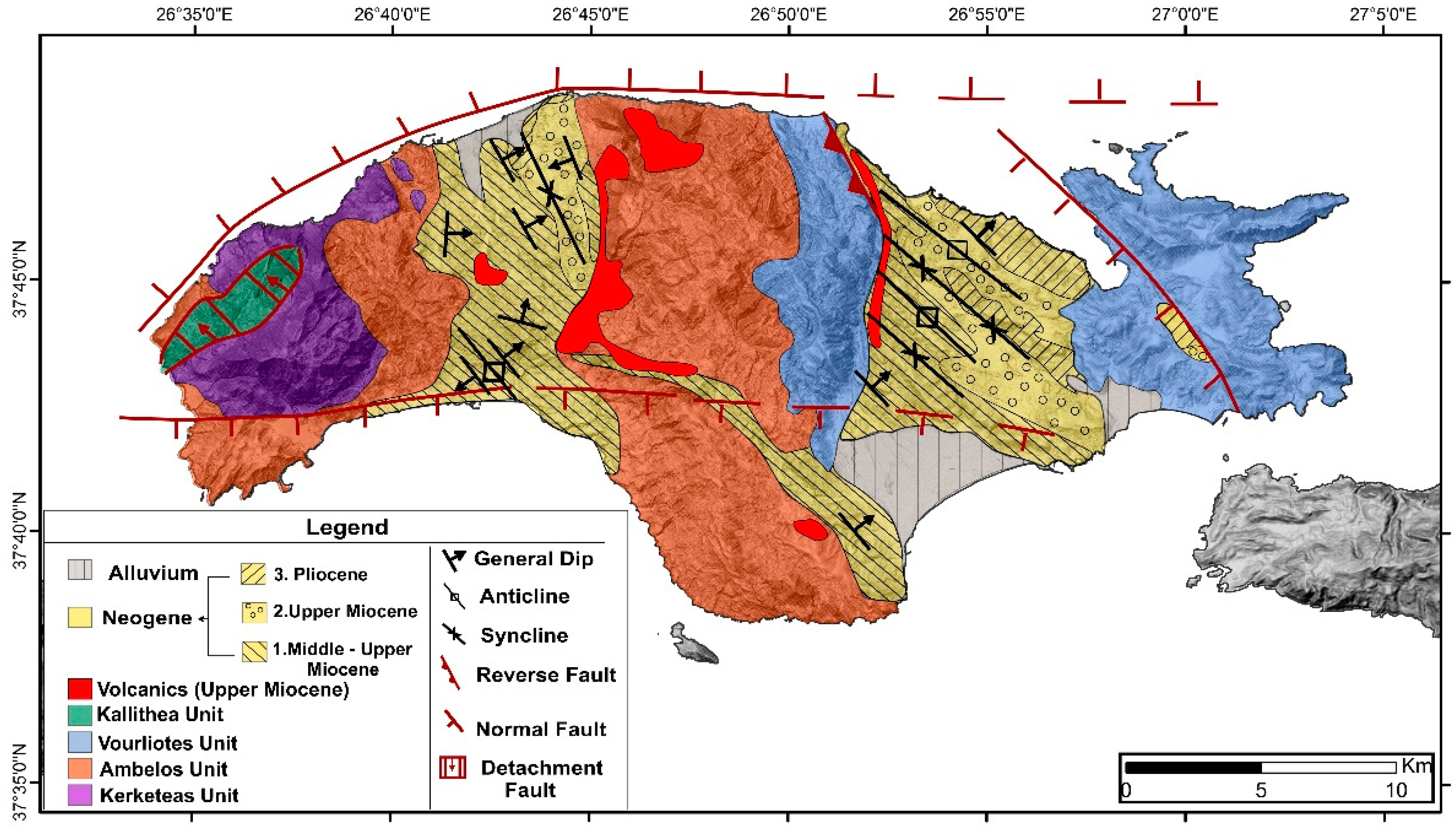
Geological Setting of Samos Island
2. Materials and Methods
3. Results
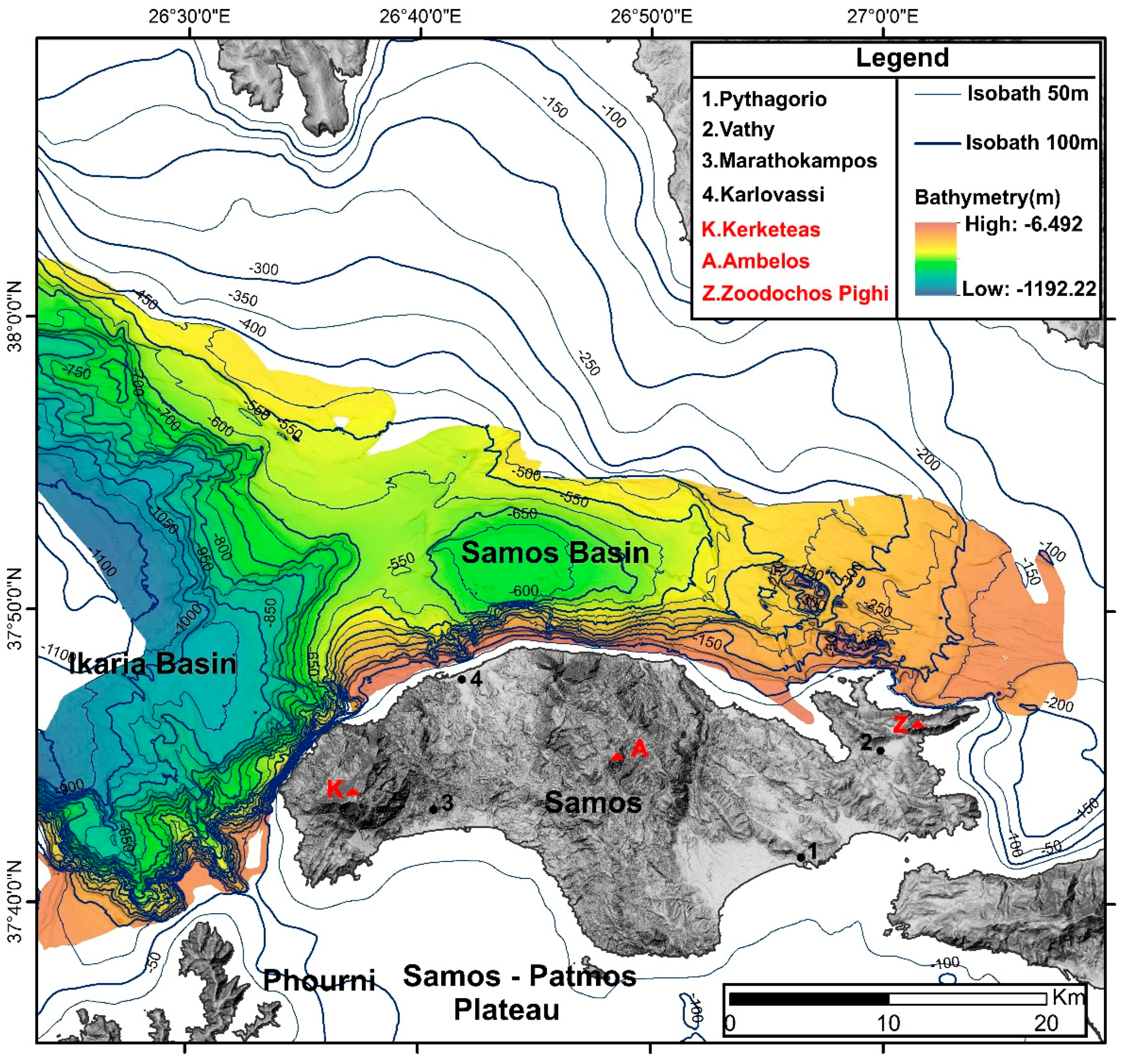
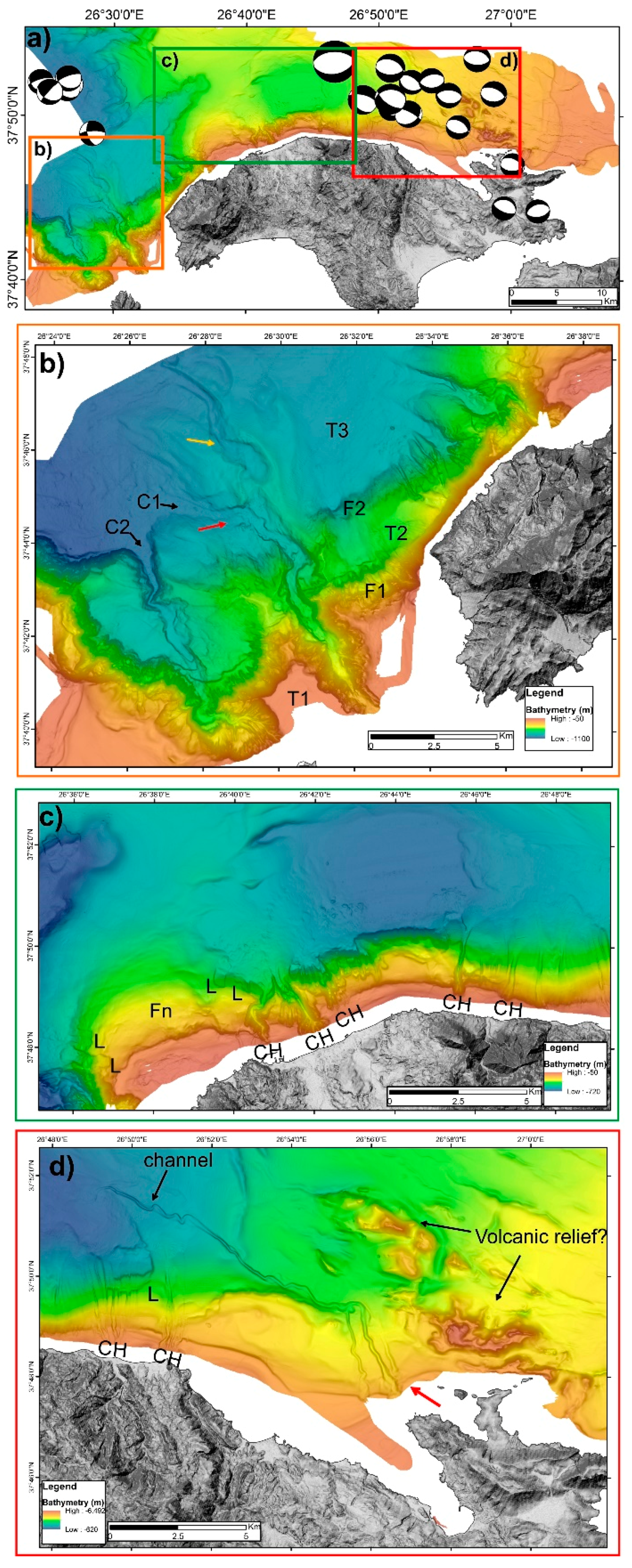
3.1. Bathymetry
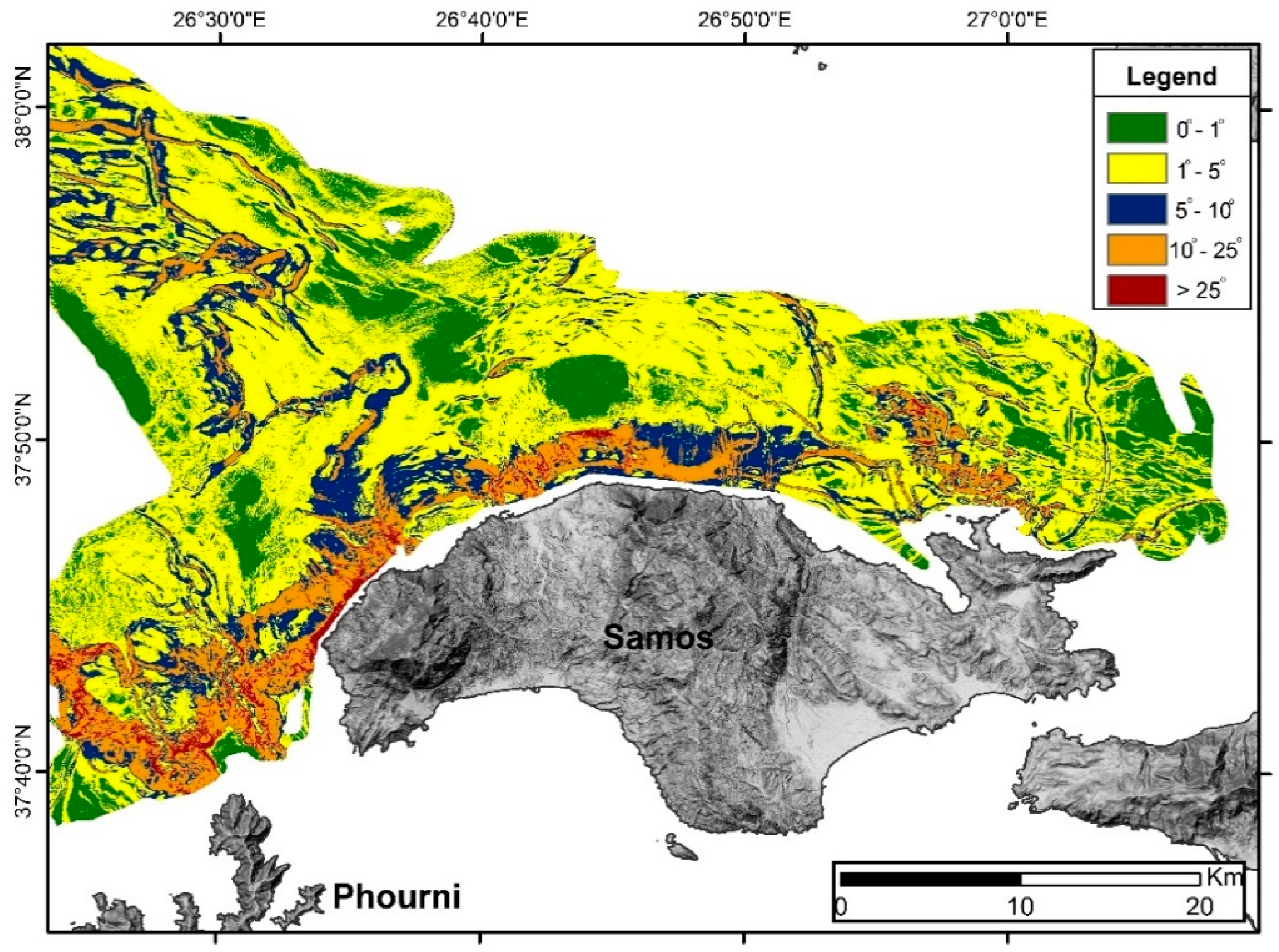
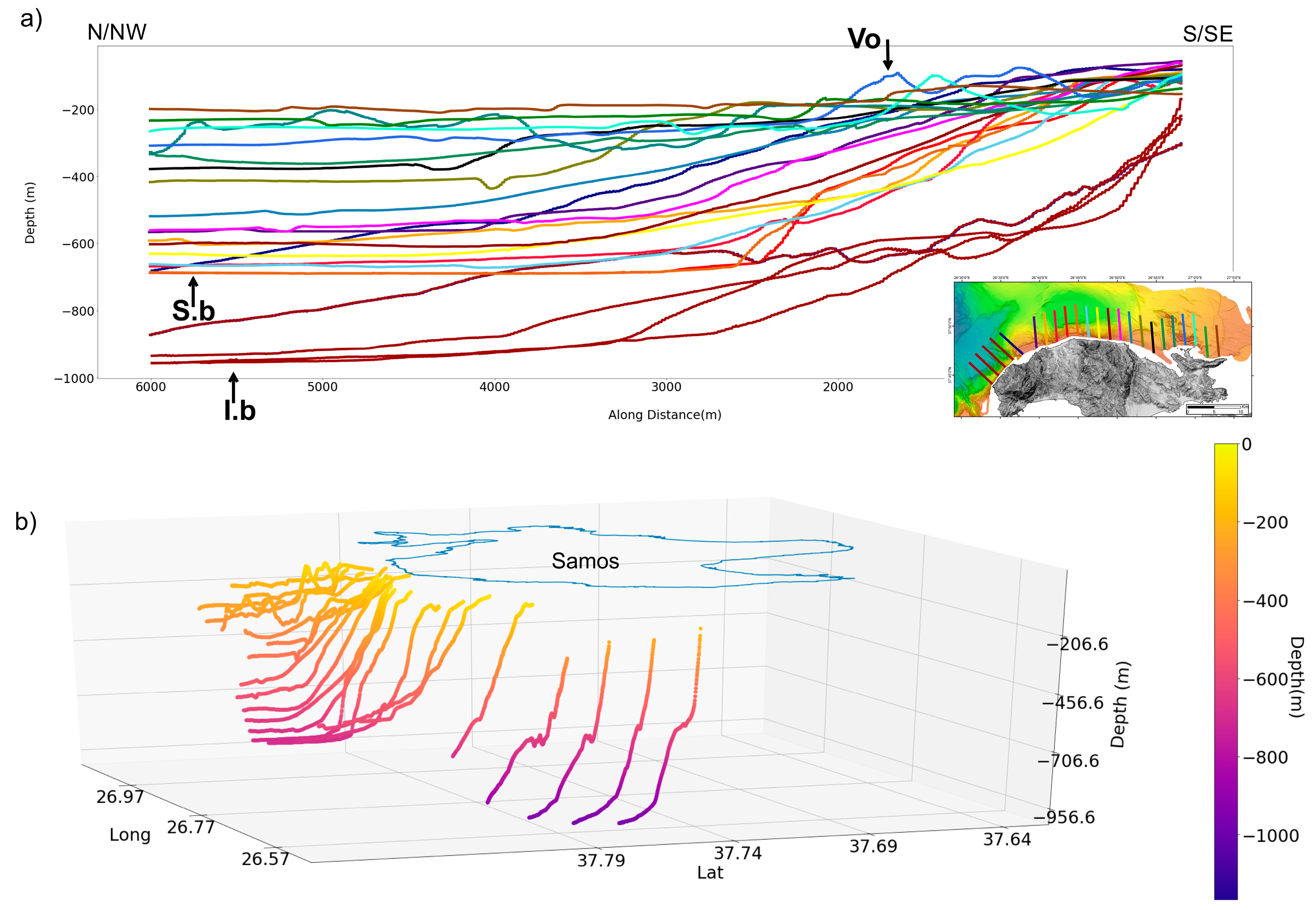
3.2. Morphological Slopes
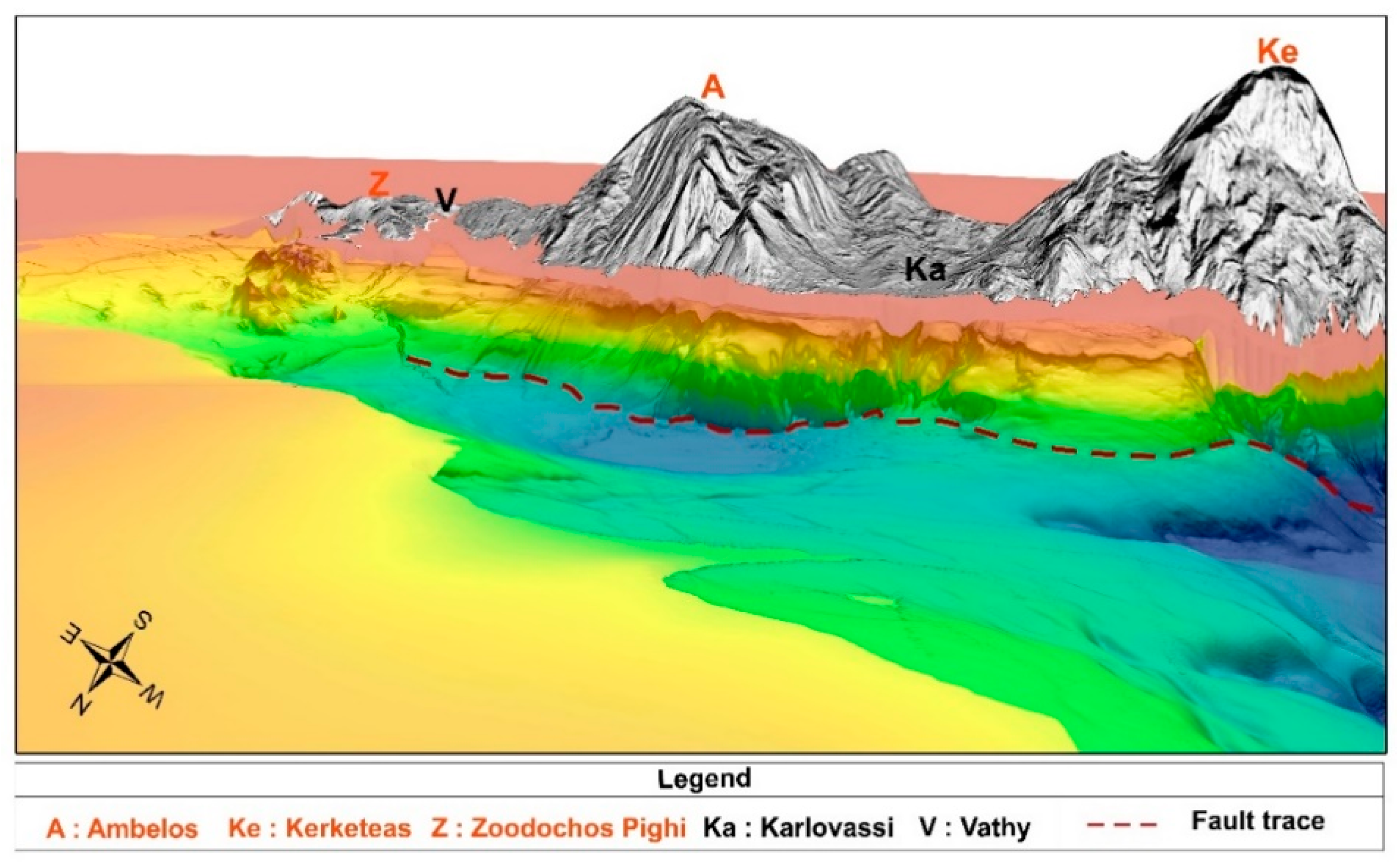
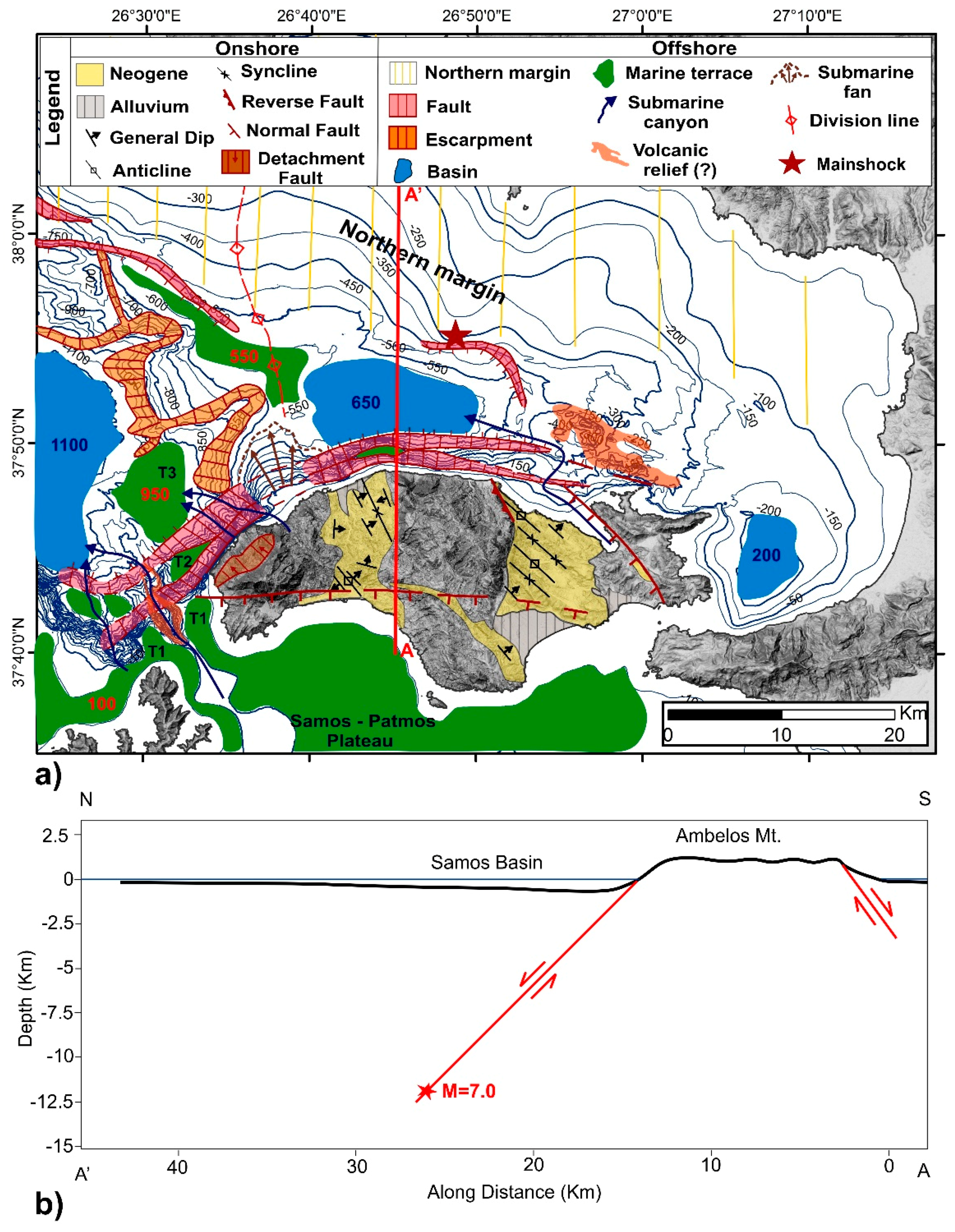
3.3. Morphotectonic Analysis
4. Discussion
5. Conclusions
Supplementary Materials
Author Contributions
Funding
Data Availability Statement
Acknowledgments
Conflicts of Interest
References
- McKenzie, D.P. Plate tectonics in the Mediterranean Region. Nature 1970, 226, 239–243. [Google Scholar] [CrossRef] [PubMed]
- McKenzie, D.P. Active tectonics of the Mediterranean Region. Geophys. J. Int. 1972, 30, 109–185. [Google Scholar] [CrossRef] [Green Version]
- McKenzie, D. Active tectonics of the Alpine—Himalayan belt: The Aegean Sea and surrounding regions. Geophys. J. Int. 1978, 55, 217–254. [Google Scholar] [CrossRef] [Green Version]
- Papanikolaou, D.; Royden, L. Disruption of the Hellenic arc: Late Miocene extensional detachment faults and steep Pliocene-Quaternary normal faults—Or what happened at Corinth? Tectonics 2007, 26. [Google Scholar] [CrossRef]
- McClusky, S.; Balassanian, S.; Barka, A.; Demir, C.; Ergintav, S.; Georgiev, I.; Gurkan, O.; Hamburger, M.; Hurst, K.; Kahle, H.; et al. Global Positioning System constraints on plate kinematics and dynamics in the eastern Mediterranean and Caucasus. J. Geophys. Res. 2000, 105, 5695–5719. [Google Scholar] [CrossRef]
- Reilinger, R.; McClusky, S.; Paradissis, D.; Ergintav, S.; Vernant, P. Geodetic constrains on the tectonic evolution of the Aegean region and strain accumulation along Hellenic subduction zone. Tectonophysics 2010, 488, 22–30. [Google Scholar] [CrossRef]
- Müller, M.; Geiger, A.; Kahle, H.-G.; Veis, G.; Billiris, H.; Paradissis, D.; Felekis, S. Velocity and deformation fields in the North Aegean domain, Greece, and implications for fault kinematics, derived from GPS data 1993–2009. Tectonophysics 2013, 597–598, 34–49. [Google Scholar] [CrossRef]
- Kreemer, C.; Holt, W.E.; Haines, A.J. An integrated global model of present-day plate motions and plate boundary deformation. Geophys. J. Int. 2003, 154, 8–34. [Google Scholar] [CrossRef] [Green Version]
- Papazachos, B.C.; Papazachou, C. The Earthquakes of Greece; Ziti Publ. Co.: Thessaloniki, Greece, 2003; p. 286. (In Greek) [Google Scholar]
- Papadimitriou, P.; Kapetanidis, V.; Karakonstantis, A.; Spingos, I.; Kassaras, I.; Sakkas, V.; Kouskouna, V.; Karatzetzou, A.; Pavlou, K.; Kaviris, G.; et al. First Results on the Mw=6.9 Samos Earthquake of 30 October 2020. Bull. Geol. Soc. Greece 2020, 56, 251–279. [Google Scholar] [CrossRef]
- Onder Cetin, K.; Mylonakis, G.; Sextos, A.; Stewart, J.P. Seismological and Engineering Effects of the M 7.0 Samos Island (Aegean Sea) Earthquake; Hellenic Association of Earthquake Engineering: Athens, Greece, 2020. [Google Scholar] [CrossRef]
- Lekkas, E.; Mavroulis, S.; Gogou, M.; Papadopoulos, G.A.; Triantafyllou, I.; Katsetsiadou, K.-N.; Kranis, H.; Skourtsos, E.; Carydis, P.; Voulgaris, N.; et al. The 30 October 2020, Mw 6.9 Samos (Greece) earthquake. Newsl. Environ. Disaster Cris. Manag. Strateg. 2020, 92–93, 1–156. [Google Scholar]
- Triantafyllou, I.; Gogou, M.; Mavroulis, S.; Lekkas, E.; Papadopoulos, G.A.; Thravalos, M. The Tsunami Caused by the 30 October 2020 Samos (Aegean Sea) Mw7.0 Earthquake: Hydrodynamic Features, Source Properties and Impact Assessment from Post-Event Field Survey and Video Records. J. Mar. Sci. Eng. 2021, 9, 68. [Google Scholar] [CrossRef]
- Evelpidou, N.; Karkani, A.; Kampolis, I. Relative Sea Level Changes and Morphotectonic Implications Triggered by the Samos Earthquake of 30th October 2020. J. Mar. Sci. Eng. 2021, 9, 40. [Google Scholar] [CrossRef]
- Ganas, A.; Elias, P.; Briole, P.; Tsironi, V.; Valkaniotis, S.; Escartin, J.; Karasante, I.; Efstathiou, E. Fault responsible for Samos earthquake identified. Temblor 2020. [Google Scholar] [CrossRef]
- Papanikolaou, D.; Nomikou, P.; Papanikolaou, I.; Lampridou, D.; Rousakis, G.; Alexandri, M. Active tectonics and seismic hazard in Skyros Basin, North Aegean Sea, Greece. Mar. Geol. 2019, 407, 94–110. [Google Scholar] [CrossRef]
- Kreemer, C.; Blewitt, G.; Klein, E.C. A geodetic plate motion and global strain rate model. Geochem. Geophys. Geosyst. 2014, 15, 3849–3889. [Google Scholar] [CrossRef]
- Mariolakos, I.; Papanikolaou, D. The Neogene basins of the Aegean arc from the palaeogeographic and the geodynamic point of view. In Proceedings of the International Symposium Hellenic Arc and Trench (HEAT), Athens, Greece, 8–10 April 1981; pp. 383–399. [Google Scholar]
- Papanikolaou, D. The three metamorphic belts of the Hellenides. A review and a kinematic interpretation. Geol. Soc. Lond. Spec. Publ. 1984, 17, 551–561. [Google Scholar] [CrossRef]
- Mascle, J.; Martin, L. Shallow structure and recent evolution of the Aegean Sea: A synthesis based on continuous reflection profiles. Mar. Geol. 1990, 94, 271–299. [Google Scholar] [CrossRef]
- Kiratzi, A.; Louvari, E. Focal mechanisms of shallow earthquakes in the Aegean Sea and the surrounding lands determined by waveform modeling: A new database. J. Geodyn. 2003, 36, 251–274. [Google Scholar] [CrossRef]
- Theodoropoulos, D. Geological Map of Greece, 1:50.000 Scale; Neon Karlovasi and Limin Vatheos Sheets; IGME: Athens, Greece, 1979. [Google Scholar]
- Papanikolaou, D. Unités tectoniques et phases de déformation dans I’ île de Samos, Mer Egée, Grèce. Bull. Soc. Géol. Fr. 1979, 7, 745–752. [Google Scholar] [CrossRef]
- Papanikolaou, D. The Geology of Greece; Patakis Publ. Co.: Athens, Greece, 2015; p. 443. (In Greek) [Google Scholar]
- Ring, U.; Laws, S.; Bernet, M. Structural analysis of a complex nappe sequence and late orogenic basins from the Aegean island of Samos, Greece. J. Struct. Geol. 1999, 21, 1575–1601. [Google Scholar] [CrossRef]
- Roche, V.; Jolivet, L.; Papanikolaou, D.; Bozkurt, E.; Menant, A.; Rimmele, G. Slab fragmentation beneath the Aegean/Anatolia transition zone: Insights from the tectonic and metamorphic evolution of the Eastern Aegean region. Tectonophysics 2019, 754, 101–129. [Google Scholar] [CrossRef]
- Chatzipetros, A.; Kiratzi, A.; Sboras, S.; Zouros, N.; Pavlides, S. Active faulting in the north-eastern Aegean Sea Islands. Tectonophysics 2013, 597–598, 106–122. [Google Scholar] [CrossRef]
- Weidmann, M.; Solounias, N.; Drake, R.E.; Curtis, G.H. Neogene stratigraphy of the eastern basin, Samos Island, Greece. Geobios 1984, 17, 477–490. [Google Scholar] [CrossRef]
- Angelier, J. Sur l’alternance mio-quaternaire de mouvements extensifs et compressifs en Εgee orientale: L’ ile de Samos. (Grece). C. R. Acad. Sci. 1976, 283, 463–466. [Google Scholar]
- Aksu, A.E.; Piper, D.J.W.; Konuk, T. Quaternary growth patterns of Buyuk Menderes and Kuyuk Menderes deltas, western Turkey. Sediment. Geol. 1987, 52, 227–250. [Google Scholar] [CrossRef]
- Taymaz, T.; Jackson, J.A.; McKenzie, D. Active tectonics of the north and central Aegean Sea. Geophys. J. Int. 1991, 106, 433–490. [Google Scholar] [CrossRef]
- Seyitoglu, G.; Scott, B.C. The cause of NS extensional tectonics in western Turkey: Tectonic escape vs back-arc spreading vs orogenic collapse. J. Geodyn. 1996, 22, 145–153. [Google Scholar] [CrossRef]
- Yilmaz, Y.; Genç, Ş.C.; Gürer, F.; Bozcu, M.; Yilmaz, K.; Karacik, Z.; Altunkaynak, Ş.; Elmas, A. When did the western Anatolian grabens begin to develop? Geol. Soc. Lond. Spec. Publ. 2000, 173, 353–384. [Google Scholar] [CrossRef]
- Stiros, S.C.; Laborel, J.; Laborel-Deguen, F.; Papageorgiou, S.; Evin, J.; Pirazzoli, P.A. Seismic coastal uplift in a region of subsidence: Holocene raised shorelines of Samos Island, Aegean Sea, Greece. Mar. Geol. 2000, 170, 41–58. [Google Scholar] [CrossRef]
- Papanikolaou, D.; Nomikou, P.; Alexandri, S.; Ballas, D. Morphotectonic structure of the western part of the North Aegean basin based on swath bathymetry. Mar. Geol. 2002, 190, 465–492. [Google Scholar] [CrossRef]
- Papanikolaou, D.; Nomikou, P.; Alexandri, S. Active faulting in the North Aegean basin. Geol. Soc. Am. Spec. Pap. 2006, 409, 189–209. [Google Scholar]
- Ocakoglu, N.; Demirbag, E.; Kuscu, I. Neotectonic structures in the area offshore Alacati, Goganbey and Kusadasi (Western Turkey): Evidence of strike-slip faulting in the Aegean extensional province. Tectonophysics 2004, 391, 67–83. [Google Scholar] [CrossRef]
- Ktenas, C. Decouverte du Pliocene inferieur marin dans l’ ile de Nikaria. C. R. Acad. Sci. 1927, 184, 756–758. [Google Scholar]
- Georgalas, G. Les terrasses littorales de la cote sud-oriental de l’ ile de Nikaria (Mer Egee). Prakt. Acad. Athenes 1953, 28, 425–434. [Google Scholar]
- Papanikolaou, D. Contribution to the geology of Ikaria Island, Aegean Sea. Ann. Géol. Pays Hell. 1978, 29, 1–28. (In Greek) [Google Scholar]
- Papanikolaou, D. Les écailles de Thymaena: Témoins d’ un mouvement tectonique miocène vers I’intérieur de I’arc égéen. C. R. Acad. Sci. 1980, 290, 307–310. [Google Scholar]
- Nomikou, P.; Hubscher, C.; Papanikolaou, D.; Farangitakis, P.; Runhau, M.; Lambridou, D. Expanding extension, subsidence and lateral segmentation within the Santorini-Amorgos basins during Quaternary: Implications for the 1956 Amorgos events, central-south Aegean Sea, Greece. Tectonophysics 2018, 722, 138–153. [Google Scholar] [CrossRef]
- Alexandri, M.; Papanikolaou, D.; Nomikou, P.; Ballas, D. Geological Structure of the Myrtoon Basin (Aegean Sea) Based on Swath Bathymetry. In Rapport Commission International Pour L’exploration Scientifique de la Mer Mediterranee; CIESM: Madrid, Spain, 2001; Volume 36. [Google Scholar]
- Nomikou, P.; Papanikolaou, D.; Alexandri, M.; Sakellariou, D.; Rousakis, G. Submarine volcanoes along the Aegean Volcanic Arc. Tectonophysics 2013, 597–598, 123–146. [Google Scholar] [CrossRef]
- Wells, D.I.; Coppersmith, K.J. New empirical relationships among magnitude, rupture length, rupture area and surface displacement. Bull. Seismol. Soc. Am. 1994, 84, 974–1002. [Google Scholar]
- Papazachos, B.C.; Papaioannou Ch, A.; Papazachos, C.B.; Savvaidis, A.A. Atlas of isoseismal maps for strong earthquakes in Greece and surrounding area. Publ. Geophys. Lab. Univ. Thessalon. 1997, 4, 200. [Google Scholar]
- Benetatos, C.; Kiratzi, A.; Ganas, A.; Ziazia, M.; Plessa, A.; Drakatos, G. Strike-slip motions in the Gulf of Siğaçik (western Turkey): Properties of the 17 October 2005 earthquake seismic sequence. Tectonophysics 2006, 426, 263–279. [Google Scholar] [CrossRef]


Publisher’s Note: MDPI stays neutral with regard to jurisdictional claims in published maps and institutional affiliations. |
© 2021 by the authors. Licensee MDPI, Basel, Switzerland. This article is an open access article distributed under the terms and conditions of the Creative Commons Attribution (CC BY) license (http://creativecommons.org/licenses/by/4.0/).
Share and Cite
Nomikou, P.; Evangelidis, D.; Papanikolaou, D.; Lampridou, D.; Litsas, D.; Tsaparas, Y.; Koliopanos, I. Morphotectonic Analysis along the Northern Margin of Samos Island, Related to the Seismic Activity of October 2020, Aegean Sea, Greece. Geosciences 2021, 11, 102. https://0-doi-org.brum.beds.ac.uk/10.3390/geosciences11020102
Nomikou P, Evangelidis D, Papanikolaou D, Lampridou D, Litsas D, Tsaparas Y, Koliopanos I. Morphotectonic Analysis along the Northern Margin of Samos Island, Related to the Seismic Activity of October 2020, Aegean Sea, Greece. Geosciences. 2021; 11(2):102. https://0-doi-org.brum.beds.ac.uk/10.3390/geosciences11020102
Chicago/Turabian StyleNomikou, Paraskevi, Dimitris Evangelidis, Dimitrios Papanikolaou, Danai Lampridou, Dimitris Litsas, Yannis Tsaparas, and Ilias Koliopanos. 2021. "Morphotectonic Analysis along the Northern Margin of Samos Island, Related to the Seismic Activity of October 2020, Aegean Sea, Greece" Geosciences 11, no. 2: 102. https://0-doi-org.brum.beds.ac.uk/10.3390/geosciences11020102