Article

Evaluation of the Environmental Risk of Contaminated Materials: Advice on the Most Appropriate Environmental Remediation Techniques

1
Department of Geosciences, Science and Technology School, Institute of Earth Science (IES), University of Évora, 7000-812 Évora, Portugal
2
AmbiTerra Laboratory—Rua da Barba Rala, No 1, Parque Industrial e Tecnológico, 7005-345 Évora, Portugal
*
Author to whom correspondence should be addressed.
Submission received: 25 February 2021 / Revised: 26 March 2021 / Accepted: 30 March 2021 / Published: 4 April 2021
(This article belongs to the Special Issue Aquatic Systems Quality and Pollution Control)

Abstract

:
This work addresses the contamination of the sediments of an alluvial plain and riverbed of a tributary of the San Francisco River, in the Brazilian state of Minas Gerais, by potentially toxic elements from an industrial unit of metallic alloys production. This area was subdivided into four areas (A1, A2, A3, and A0 (background area)) where sediment samples have been collected followed by geochemical characterization and spatial distribution of the contaminants. This characterization was based on the (1) analysis of dissolved elements in the interstitial waters, (2) identification of exchangeable and carbonates bounded fractions, and (3) leaching tests using deionized water adjusted to the local pH. This analysis revealed high levels mainly in Cd, Pb, and Zn, in the interstitial waters and in the more soluble phases of sediments. The comparison between the levels of these elements in the leached extracts and the more soluble fractions corroborates the high capacity of these elements to be leached from the alluvium following precipitation episodes. The geochemical characterization and spatial distribution of the contaminants will allow, in the near future, a choice of the most appropriate environmental remediation technique(s) for the environmental requalification of this area.

1. Introduction

Contamination by potentially toxic elements is one of the most frequent forms of environmental pollution and it is mostly associated with anthropogenic sources. Their accumulation and distribution in soils, sediments, and waters is a highly dangerous factor since they directly affect the water reservoirs and, subsequently, the living organisms are dependent on it [1]. Some metals such as Cu, Fe, Mn, Ni, and Zn are, in low concentrations, essential as micronutrients for the metabolic processes in animals and plants [2], while other metals, such as Cd, Cr, and Pb, present high toxicity even in trace levels. Rivers and streams are the main transportation ways of these metals, both in dissolved and particulate form, making these elements one of the main environmental hazards, especially in aquatic environments [1]. Metals are non-degradable elements, which can accumulate in the human body, causing damage to the nervous system and internal organs [2]. This type of contamination is mainly associated with the deposition and mobilization of toxic wastes, rich in these elements, in soils located in the vicinity of areas with high industrial activity. Metals can easily infiltrate and move in dissolved and suspended forms in the interstitial water through soils and alluvial materials and can also move by surface run-off towards the watercourses. The mobility of these chemical elements is one of the most relevant factors for the assessment of their environmental impact, toxicity, and bioavailability [3]. Their mobility is associated with several factors, which may be conclusive for a few metals but, on the other hand, it may lead to the immobilization of others existing simultaneously in geological materials. Thus, their behavior in the environment should be taken into account when planning a remediation project [4,5]. The use of remediation techniques to reduce the toxicity level of the existing contaminants and to recover contaminated soils, sediments, and water courses, cost-effective and with reduced execution times is of great importance and, becomes increasingly necessary [4,6]. However, the success of a remediation technique involve, in the first instance, the contamination sources control. The choice of the most appropriate environmental remediation technique(s) depends not only on the nature of the contaminants but also on the intrinsic characteristics of the geological materials [7]. Remediation of soils, sediments, groundwater, and water bodies is usually a complex task that requires the collaboration of multidisciplinary teams of qualified professionals with experience in the elaborations of precise diagnoses and in the definition of the most adequate technology [4,8].
Given the fragilities of an area contaminated by potentially toxic elements, the main goal of this work is to achieve the geochemical characterization and the spatial distribution of potentially toxic elements in a floodplain and in the riverbed sediments of a tributary of the San Francisco River, in the Brazilian state of Minas Gerais, which is under the influence of an industrial unit of metallic alloys production located in its margins. The incorrect disposal of industrial waste and the insufficient legislation promoting the appropriate storage of waste has led to the accumulation of high concentrations of potentially toxic elements in the study area. This work is inserted in a wide study which has as main objective the environmental recovery of this industrial area, in order to minimize the spread of the toxic levels of metals. Despite its high flow rate, the waters of the San Francisco River are increasingly susceptible to contamination, due to the different activities in its margins, such as industries, livestock, agriculture, housing, and land traffic [9,10,11]. The risk is further increased for riverine populations and for those who use river water for agricultural and domestic purposes, as well as for activities related to fishing or tourism, which are very important economic sources in the region [10,11]. Therefore, the high utilization rate of the waters of the San Francisco River makes it very important to monitor and manage its watershed, in order to not compromise its ecological quality. The accurate and complete geochemical characterization and spatial distribution of the contaminants in the sediments of this floodplain and the riverbed of the San Francisco River tributary is intended as a first step towards the environmental requalification of this industrial zone, which is posing the largest Brazilian river a serious risk. This study intends to provide the main tools for the choice of the most appropriate environmental remediation technique(s) to be implemented in a short term. The characterization of the contaminant levels was achieved by field and laboratory works, with the extensive collection of sediment samples from both, alluvial plain and riverbed of the San Francisco affluent which is most affected by this industrial area.
This work first presents an overview of the study area, followed by the field and laboratory methods applied. The integration of the field and lab data makes it possible to provide an accurate description and zonation of the contamination status in the target area, enabling the advice of the most appropriate strategy for its remediation.

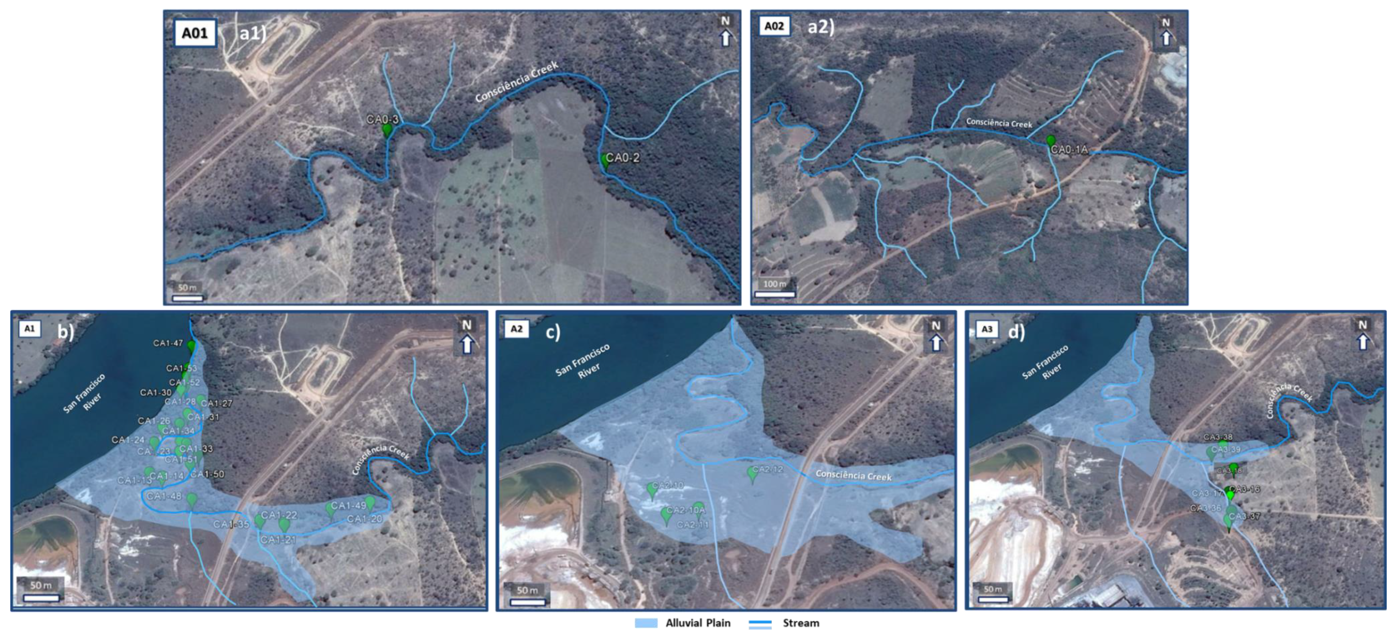
2. Overview of the Study Area

The study area, in the vicinity of a large industrial unit of metallic alloys (mainly Zn processing), is located in the Três Marias municipality, in the Brazilian State of Minas Gerais. The plant is set in one of the banks of the San Francisco River and on the banks of a small tributary (Consciência Creek), which accompanies the entire industrial area and whose alluvial plain receives very high levels of the various metals processed in the unit, in soluble or particulate form, transported either by surface runoff and/or infiltration. The geochemical characterization of the contamination focus in the alluvial plain and in some sediments deposited in the riverbed of this small watercourse, Figure 1.
Geologically the study area is included in Três Marias Formation which belongs to the Bambuí Group. The Bambuí Group, the largest group in the San Francisco Craton, represents the most characteristic unit of the basin and it includes fractions of altered carbonate rocks, spread over different formations including the Três Marias formation [12]. This formation is at the top of the Bambuí Group consisting of a thick sedimentary sequence represented by layers of sandstone of fine to very fine grain size, interlayered with arcosic siltstones rich in quartz, feldspar and heavy/dense minerals of iron oxides, tourmaline, zircon, epidote, and garnet, with an approximate age of 600–650 Ma [12,13,14], Figure 2.
The San Francisco River is one of the most important rivers in Brazil because besides being a river that flows entirely in Brazilian territory, it has a high extension and it has great economic importance, especially related to fishing, irrigation, navigation, having a very important role in the urban supply and rural communities [9,10]. In the area occupied by Três Marias Dam and its surroundings, where the study area is located, the major aquifer is composed of fissured rocks, with groundwater flowing along discontinuity planes and infiltration taking place along the weathered zones [10]. This kind of fissured rocks are generally more vulnerable to contamination if they are not overlaid by low permeability residual soils that increase natural attenuation and contaminant retardation [10,11].
According to the legal parameters legislated in Brazil, surface waters can be classified by their use into 5 classes, the San Francisco River falling into Class 2, which corresponds to water intended for human consumption after conventional treatment, protection of aquatic communities, recreation of primary contact such as swimming, water skiing and diving, irrigation fruit trees and parks, gardens, sports, and leisure fields, with which the public may come into direct contact and/or aquaculture or fishing activity [16]. The Consciência Creek merges with San Francisco River downstream of the old tailings dam of the industrial unit. This stream begins in the vicinity of Três Marias town, with about 11.5 km2 of drainage area. It has a low slope, next to the industrial unit, with a reduced depth and widths (not exceeding 4 m) near the mouth, which explains its poor hydrodynamics [10].
Climatically, the study area has a savanna tropical climate, characterized by a marked seasonality, with an average annual temperature of ≈24 °C and an annual thermal amplitude from 12 °C to 14 °C, average annual precipitation of ≈1000–1500 mm concentrated in the summer months and with a torrential regime [11,17]. The climatic seasonality is an important interference factor in this study due to its role in the occurrence and behavior of heavy metals in this watercourse and alluvial materials. In the rainy season, the surface flow transports high loads of particles deposited in the drainage basin and the movement of the soluble phases that cross soils and alluvial materials is much more accelerated, altering the geochemical conditions of the water [4].
The process of implementation of the Três Marias industrial unit along the banks of the San Francisco River, began in 1959, with the development of zinc ores, from silicates, extracted from two mines near this plant (Vazante and Morro Agudo mines) [4,18,19]. The choice of this location had as decisive factors, the proximity to basic resources (water and electricity) necessary for the industrial operation and for the electrolytic process, required for obtaining metallic zinc alloys [4,18]. From the beginning, the industry has continuously increased the zinc metal production capacity in ingots (cast metal sheets) and high-grade electrolytic zinc. However, it was from 2002 onwards, with the implementation of the metallurgical beneficiation process of zinc in mixed system, with the subsequent increase of the capacity for processing of the silicate ore from both mines that production has reached the highest levels. From 2002 to nowadays the production reaches 180 thousand tons/year of metallic zinc [4,18,19]. This industrial unit has caused from the beginning of its operation vast environmental problems. Until the 1980s, due to the absence of appropriate environmental legislation on waste disposal, no adequate measures were taken, with the waste disposed over large areas on the banks of the San Francisco River [4,17]. Thus, the unit unleashed numerous environmental problems in the soils surrounding the unit, in the alluvium, sediments of the margins and deposited in Consciência Creek, in its water column, and even in the bottom and margins of San Francisco River. In 1983, the company’s first repository was built, the Old Dam, located on the right bank of the San Francisco River, Figure 1. The wastes were stored in the dam directly on the ground without any waterproof. This dam remained active until 2002, when it was completely flooded. Over the years, there were episodes of pollution in the surrounding soils and in the waters of the river, associated with high mortality of fish. These problems led to the closure of the dam and to the construction of a new waste dam, located about 6 km from the plant, Figure 1, [4,9,10,12]. This dam, built in accordance with the directives of the local environmental agencies, receives the tailings from the industrial process since 2002. Avoiding the deposition of the waste directly on the surface [4,10]. Contrary to what would be expected, this dam was also inefficient as a container for all the wastes produced in the unit, leading to its closure in 2011 [4,11,20,21]. With the purpose of stopping the contamination caused by these two waste dams in 2011 the Murici Deposit was built, Figure 1. This new deposit was built according to the latest required environmental parameters, it is totally waterproofed, and it is a target of periodic monitoring, ensuring the storage of the residues coming from the current industrial production and the residues previously deposited in the two inactive dams [4,20].

3. Methodology

3.1. Sampling

The study area was subdivided into four areas, based on a previous diagnostic study carried out by Golder Associates Company, which identified two types: degraded areas and contaminated areas. Contaminated areas correspond to areas where the contents identified in the samples exceeded the LAV (legally admitted values). LAV is, according to Brazilian regulations, the concentration above which there is a potential risk to human health [22]. Degraded areas are the areas where the contents of elements identified in the samples were close to the LAVs admitted for each element [18].
The alluvial sediments were collected in the areas classified as contaminated, which were divided into areas A0 (representative of the geochemical background, samples were collected in areas upstream and outside the influence zone of the industrial activity), A1 (sediments deposited in the margins and in the riverbed of Consciência Creek), A2 (the widest and thickest part of the alluvial plain) and A3 (alluvial plain and riverbed of a secondary watercourse), Figure 1 [4,23,24]. In each area, several points were selected according to a rectangular sampling system, with spacing between 50 and 100 m, and, where possible, it was considered areas of variable topography, to ensure an effective sampling in all alluvial zones, namely: (1) sediments deposited in the floodplain, corresponding to the emergent area where the largest volume of alluvium is found. It contains sediments mixed with large quantities of industrial tailings, only embedded in periods of intense precipitation. During the long dry season, they form an extensive sedimentary platform, covered by a thick layer of metallic sulfates; (2) sediments deposited in the margin of the stream, at a lower level than those deposited in the floodplain, where, they are periodically embedded, and (3) sediments deposited in the bed of the Consciência Creek at water depth varying from 30 cm to 2.5 m.
Three sampling campaigns were carried out in two distinct seasonal periods, two during the dry season (September and November 2013) and the third in the rainy season (March 2014). In these campaigns, some samples were collected exactly at the same place in order to understand the influence of seasonal conditions on the concentrations and chemical behavior of the metallic elements, Figure 3.
The sediments from the extensive floodplain were collected using a 100-cm deep drill-cores, at five depths, whenever possible (0 to 20 cm, 20 to 40 cm, 40 to 60 cm, 60 to 80 cm, and 80 to 100 cm), to verify the variation in depth of the contents of metallic elements and the chemical form in which they occur. From the margins and the stream bed, samples were collected with a manual Shipeck dredge, and with a Kajak core sampler. In some locations, the 0–20 cm surface layer was further subdivided into 5 cm-layers samples. The core samples were frozen on the day of sampling, allowing the best preservation and extraction from the PVC tubes, used as liner. All other samples were preserved at about 4 °C (from the time of collection). In addition, interstitial water were collected in alluvial and riverbed sediment samples with medium to high humidity content, using rhizome samplers, in order of determining the potentially toxic elements in dissolved forms. Replications were made for all the pore water samples preserved from the time of extraction with, concentrated nitric acid (HNO3) so that a pH value of 2–2.5 was reached, thus avoiding the occurrence of metals precipitation [4].

3.2. Laboratory Methods

In order to replicate the leaching imposed by a regional rainfall regime characterized by sudden and intense rainy periods, which can cause flooding of the study area, the extractable fraction was determined by stirring the sediments with an aqueous solution with pH corrected to the chemical characteristics of the rainfall of the region—about 6.4–6.5 [4,23,25]. The leaching was performed by continuous stirring—in an orbital shaker—of samples after drying up to 48 h, and subsamples were withdrawn after 1, 3, 18, 24, and 48 h of stirring [4]. Samples were also subjected to extraction with ammonium acetate (CH3COONH4). This process is based on the solubilization of the more labiles fractions (existing in solution, as exchangeable cations and bounded to carbonates), in order to evaluate the bioavailability of elements in the environment. These methods correspond to the first step of the sequential extraction program, adopted, from the classic model of Tessier in 1979 [26,27,28]. The extraction with ammonium acetate was performed with 1 g of dried sample to which 20 mL of 1 M ammonium acetate at pH +/− 4.5 was added, followed by continuous stirring in an orbital shaker for 10 h. Samples were then centrifuged and the supernatant was filtered and refrigerated [4,28]. All the chemical elements (Al, As, Cd, Cr, Cu, Fe, Mn, Ni, Pb, and Zn) existing in the interstitial waters and in the solutions resulting from the leaching test, and from the extraction with ammonium acetate, were analyzed by optical emission spectroscopy with inductive plasma source (ICP-OES, Perkin-Elmer OPTIMA 8300). The operation conditions were the following: plasma gas flow—8 L/min; auxiliary gas flow—0.2 L/min; nebulizer—MicroFlow PFA-ST operated at a gas flow rate of 0.70 L/min; sample flow—1.50 mL/min; RF Power—1450 watts; viewing modes—radial and axial; reading time—0.02–2 min; read delay—80 s; normal resolution; internal standard—yttrium. Chemical analyses were carried out with three replicates for quality control. The spatial distribution maps were built in the software SURFER12 using the Kriging interpolation method.

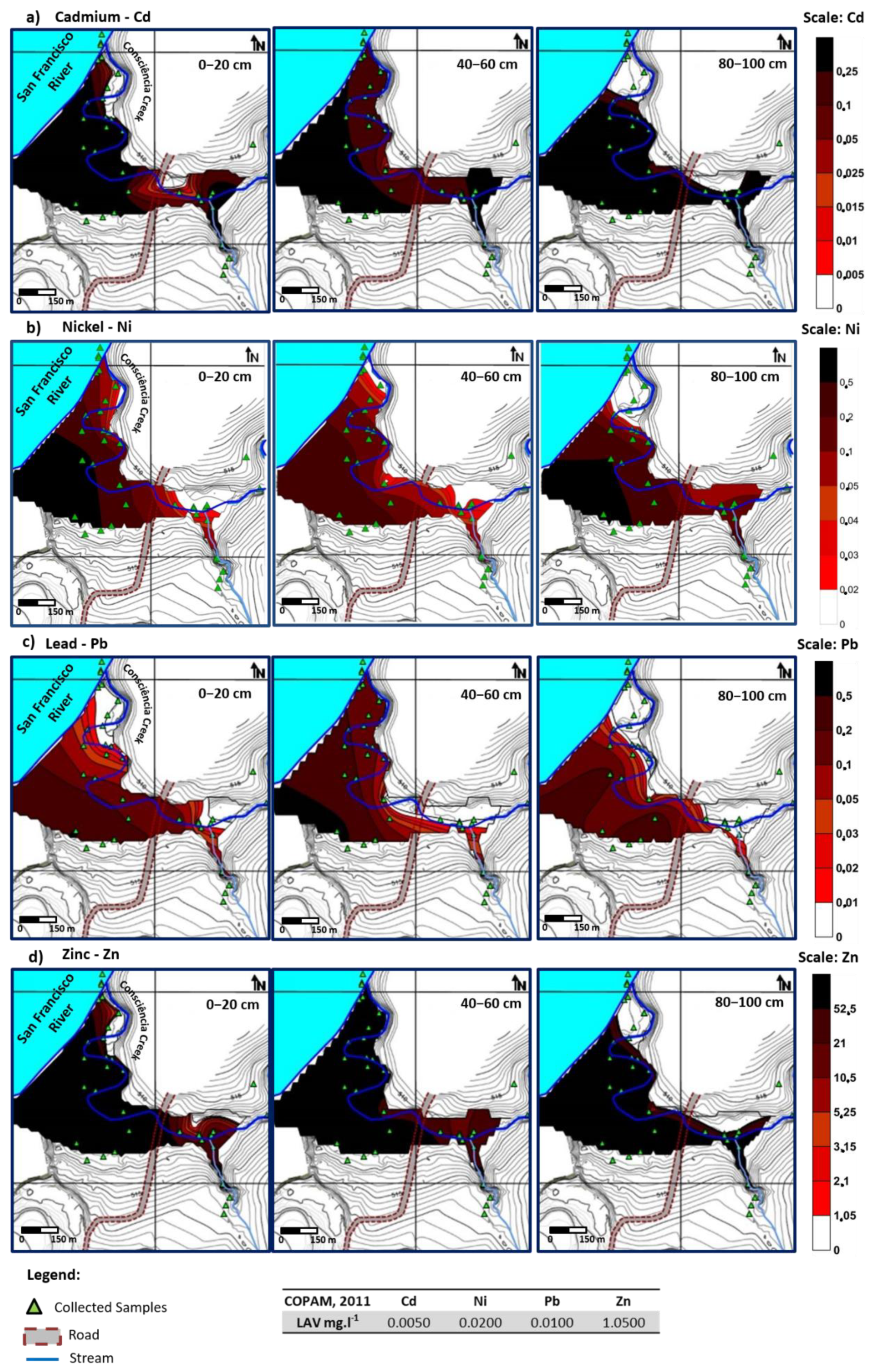
4. Results and Discussion

4.1. Interstitial Waters

The average contents of heavy metals (and arsenic) in the interstitial waters extracted in the various alluvial samples collected during the drought and rainy seasons are shown in Table 1 and Table 2.
The values achieved for interstitial water, in the absence of legal values for this type of water, were compared with the legally admitted levels for groundwater [22]. From this comparison, it was verified that the average levels obtained reached, in most cases, levels higher than the legally admitted values (LAV). Higher levels were obtained for the majority of the analyzed elements, both in the dry and in the rainy seasons. For Cd, average levels of 1.372 mg·L−1 (sample CA1-14—rainy season) were identified, while a LAV is 0.005 mg·L−1. In the same sample, the average values of Mn range between 89.312 mg·L−1 in the dry season and 41.921 mg·L−1 in the rainy season. Other samples such as CA2-12 have similar high values ranging between 16.475 mg·L−1 (rainy season) and 101.850 mg·L−1 (dry season) with a LAV of 0.400 mg·L−1. The average Ni content was higher in the dry season. For instance, sample CA1-14 has 0.331 mg·L−1, of Ni which has 0.020 mg·L−1 as LAV Pb presented similar average values to the legal limit admitted in the two seasonal periods. Similarly to Cd, Zn (the main contaminant of the study area) represents a serious environmental problem, having in the CA1-14 sample, for example, contents of hundreds of times higher than the LAV (1.050 mg·L−1), with the average concentrations in the dry season of 522.202 mg·L−1 and in the rainy season of 714.473 mg·L−1, Table 1 and Table 2. The variation of the contaminants concentration in the seasonal period does not allow identifying common patterns among the samples, however, there are significant differences between the two seasons, with concentrations tending to decrease during the rainy season, Table 1 and Table 2. This behavior is probably related to the dilution effect of the rainwater and consequent leaching of metals to the deeper zones. On the contrary, during the dry season, there is an increase in the concentration of contaminants, which may be due to the evapotranspiration and consequent drag of pollutant elements from the deeper zones to the surface, Table 1 and Table 2 [4,23,24].
The analysis of the geochemistry of the interstitial water in relation to the total concentration of contaminants in the sediments, corresponds to a first approximation for the identification of the elements with the greatest environmental hazard as their concentration in mobile phases are the most harmful to the environment. Thus, and considering these more mobile concentrations, the values obtained at several depths (0–20, 40–60, and 80–100 cm) were interpolated, using kriging, to illustrate the spatial distribution of the most hazardous contaminants (Cd, Ni, Pb, and Zn), Figure 4 [22].
This interpolation demonstrated a general agreement with the geochemical behavior for most interstitial water samples. Cd presents contamination values, at all depths, with values 10 to 50 times above its reference limit for groundwater (LAV) (0.0050 mg·L−1) [22], Figure 4 and Table 1. In general, contents increase to the discharge zone, as expected from a contaminant plume where the primary source was removed years ago [4]. Higher levels tend to occur with increasing depth (80–100 cm), especially during the wet period. Ni also presents levels above the LAV for groundwater (0.0200 mg·L−1) [22] at all the depths considered, Figure 4 and Table 1. However, despite the high general contents, it has higher concentrations in the whole alluvial area in the more superficial and intermediate layers (0–20 and 40–60 cm), which may be related to a higher geochemical dynamism enhanced by the infiltration of the surface water and to a higher groundwater circulation near the surface, due to the rise of the water table. The proximity to the Consciência Creek seems to contribute as a natural attenuation factor, through the dilution effect or the discharge of this contaminant. Pb content in the interstitial waters is also higher than the LAV (0.0100 mg·L−1) [22] for all the depths considered, Figure 4 and Table 1. At 40–60 cm depth, Pb levels exceed 20 to 50 times the reference limit at some locations of the alluvial plain. For the remaining depths, Pb was also found with contents 2 and 5 times above the limit for groundwater (LAV). Zinc, the main contaminant in the study area, Figure 4, shows an average concentration 50 times higher than that of reference value in groundwater (LAV) (1.0500 mg·L−1) [22], at all the analyzed depths and all over the alluvial area. However, despite the widespread distribution of all the elements considered, there appears to be a decrease in their concentrations in the samples collected along the edge of the Conciência Creek and near the mouth of this stream. This phenomenon, in which lower concentrations are found in the vicinity of the discharge zone to the San Francisco River, could result from natural attenuation processes and from the removal of the primary source of contamination [4]. Consciência creek seems to represent a dilution line of the contamination, especially in the superficial layers of the sediments, demonstrating the mass exchange between the mobile phase of sediments and the water column of the stream. However, despite this possible natural attenuation effect, the concentrations are still much higher than the admissible.
The geochemical characterization of the studied area revealed high contamination in heavy metals, such as Zn, Ni, Cd, Co, Cr, Cu, Pb, and As. At high levels of these potentially toxic elements, high concentrations of iron (Fe) and manganese (Mn) are associated, characteristic of tropical sedimentary environments. These elements occur mostly in mobile forms, with high bioavailability, and at levels much higher than those allowed by environmental regulations for industrial areas [23,24,25].

4.2. Leaching Tests

The leaching tests were performed to understand which components mobilize easier by contact with water. Taking into account the average results obtained in Table 3, it is clear that leaching is more pronounced for Cd and Zn, which show average contents above the legally accepted value (LAV) for most samples and for all the stirring periods with the aqueous solution with pH set to local rainwater. The Pb concentrations are above the LAV in a few samples, while in others values are lower than the detection limit. Results also show that the maximum concentrations were achieved after 18 h of stirring. As examples, it can be referred the average value of Cd of 0.276 mg·L−1 (LAV: 0.005 mg·L−1) in the sample CA2-10, values of 0.032 mg·L−1 for Pb (LAV, 0.010 mg·L−1) in the sample CA1-33 and 35.333 mg·L−1 for Zn (LAV: 1.050 mg·L−1) in the CA2-12 sample, Table 3.
From the analysis of the graphs, Figure 5, two distinct behaviors for Cd and Zn are visible. The first behavior was identified in the samples from the background area (A0) where it was observed a Cd increase, up to 18 h of stirring a few samples, while others (e.g., CA0-1A 10–20, CA0-2B 20–40) show an increase up to 24 h followed by a subsequent decrease to the end of the test (48 h). Zinc concentration also increased up to 24 h (CA0-2B 0–20, 20–40, and 40–60), with a marked decrease from that period until the end of the experiment in samples CA0-1A 0–20 and CA0-2B 20–40. The second behavior, verified in the other areas (A1, A2, A3), identified increases in concentrations of both Cd and Zn over the entire test period, with concentrations above the LAV in most of the samples in all the areas, Figure 5. The first behavior corresponds to samples located upstream of the contamination source, which may be associated with less solubility and consequently to less leachable fractions of Cd and Zn, thus reaching, maximums concentrations after 18 h for most of the cases. For the 24 h period and, only for Zn, there were slight variations in the leachable contents, which could denote the attainment of the system equilibrium. In the more contaminated areas, the leaching behavior may be explained by the gradual dissolution of the mineral phases where these potentially toxic metals are associated and/or to the release of the adsorbed or fixed forms from the exchangeable complex of mineral or organic components. Thus, it can be seen that, once again, the two major contaminants (Cd and Zn) in the area have a high solubility rate, corroborating their high solubility by rainwater only after one hour of stirring. When compared to the LAV [22] in all the areas under the influence of the industrial unit, there is a clear violation of the legislated limit for groundwater, Figure 5.

4.3. Ammonium Acetate Extraction

To better understand the significance of the fraction of the sediments extracted with ammonium acetate, which corresponds to the first fraction of the Tessier sequential extraction procedure [26,27], and its relationship with the fraction leached under the effect of precipitation, runoff, or increased water flow, the concentrations of the elements extracted in this first step of chemical fractionation, were compared with the concentrations obtained in the leaching test. This comparison has the objective of quantifying the rate between the most easily removable fraction by water and the most labile fraction extracted in the first step of metals fractionation. The average contents obtained by the ammonium acetate extraction method are shown in Table 4.
The obtained values, Table 4, through ammonium acetate extraction reveal high mobility in what concerns Cd, Pb, and Zn with levels higher than LAV—level of attention and critical in most samples. In the A1, A2 and A3 areas, contents of Cd, between 8.514 mg·kg−1 (CA1-33) and 27.313 mg·kg−1 (CA2-10A), and of Zn between 1610.102 mg·kg−1 (CA1-21) and 12,098.837 mg·kg−1 (CA2-10), were higher than the LAV—critical level, which is (>3.5 mg·kg−1) for Cd and (>315 mg·kg−1) for Zn. In addition, values of Pb between 36.022 mg·kg−1 (CA1-21) and 626.532 mg·kg−1 (CA1-33), range from higher than LAV—critical level (>91.3 mg·kg−1) and LAV level of attention (35–91.3 mg·kg−1). Cu levels range from normal to critical levels. However, the high concentration of this element has less expression than in the case of Cd, Pn, and Zn. Some higher contents found in a few elements in samples from A0 area, classified in the levels of attention and critical may be related, as mentioned before, to the eolic transport of particles or to the transport of tailings between the plant and the Murici deposit, Figure 1.

4.4. Comparison of the Data from Leaching after 18 h of Stirring and from the Extraction with Ammonium Acetate

Figure 6 plots the comparison for Cd and Zn, using the results after 18 h of stirring in the leaching test since it represents the maximum leachable for most samples, and the results obtained from the extraction with ammonium acetate. In general, extraction with ammonium acetate has a higher metal removal capacity than with just water stirring, which may be due to the more acidic pH of the acetate solution, allowing the instability and solubilization of more mineral phases (for example carbonates) which are not fully extractable with water. Cd and Zn are the elements that are more prone to be extracted by stirring with water, and are therefore the contaminants with lower stability and higher possibility of remobilization, as demonstrated by their high concentrations in leachates, Table 4. These values, for some samples, are very close to the levels extracted by ammonium acetate, Figure 6, denoting once again their high environmental hazard, since they are easily mobilized.
The interstitial waters correspond to the aqueous fraction found in the pore of the alluvial sediments analyzed, and this fraction can be considered as part of the groundwater. Its percolation and presence in the pores of the alluvial samples promote the main elementary exchanges between the sedimentary materials and the water column. Thus, considering the high levels identified in this fraction, it can be concluded that the potentially toxic elements (Cd, Mn, Ni, Pb, and Zn) present a high ratio of soluble phase, and therefore they are highly mobile and are, easily leached to the river basin only by the effect of rainwater. The interstitial waters correspond to the most labile and easily extracted through the sequential extraction procedures and its analysis, allowed the identification of the most hazardous contaminants of the alluvial zone. The construction of maps of spatial interpolation allows a more clear demonstration of the impact of the distribution of contamination on the entire floodplain area, also evidencing the most affected depths by the contaminants, as well as areas of possible natural attenuation by the Consciência Creek. The natural attenuation development represents a set of physical, chemical, and biological processes that reduce the mass, toxicity, mobility, volume, or concentration of contaminants in soils, sedimentary deposits, and groundwater without human intervention. This phenomenon is based on processes such as biodegradation, dispersion, dilution, “sorption”, volatilization, and stabilization (transformation or chemical and biological destruction of the contaminant) [4,28,29]. With regard to the study area, the contamination plume presents lower levels in a few areas of the alluvium as a consequence of the removal of the primary sources of contamination and of natural attenuation mechanisms. These mechanisms can include effects of dilution and dispersion due to rainwater infiltration and to the metals migration under the effect of the hydraulic gradient from the center of the contamination plume to the discharge zone.
Considering the high concentration of pollutants in soluble and easily solubilizable fractions, leaching tests were necessary in order to identify which contaminants are more easily extracted by the pH-adjusted water solution to local rainwater. These tests allowed the evaluation and quantification of the elements that are more easily solubilized and enter in the hydrological system, as a consequence of the precipitation.

5. Conclusions

The analysis of the results allowed to identify in all the areas (A1, A2, and A3), levels of the leached potentially toxic elements higher than the legally legislated values for groundwater, thus identifying the high degree of danger of elements such as Cd, Pb, and Zn. Comparison of the values obtained in the leaching tests with those identified in the first step of the sequential extraction (ammonium acetate) showed a relative stability for Cr, Cu, Fe, and Pb, while for Cd, Co, Mn, and Zn they are similar to the values obtained by extraction with ammonium acetate. Considering these results, the most dangerous elements are Cd, Co, Mn and Zn, because they are easily extractable in toxic concentrations only by stirring with water, allowing the conclusion that whenever it rains, high solubilization rates occur followed by the drag of these elements to the water column of the Consciência Creek and, consequently, to the San Francisco river.
Given the contamination characteristics, the recovery of this area will imply the adoption of different remediation techniques, which will ensure the decontamination of all the alluvial area, the groundwater, and the surface water of the Consciência Creek. Ideally, in order of having an effective and not merely a temporary solution, the inhibition of the toxic element migration to the San Francisco River, must necessarily include the removal of any source of pollution from the area. For the remediation process, it is suggested the installation of a PRB (permeable reactive barrier) in the alluvial plain near the discharge zone of the Consciência Creek to the San Francisco River, aiming at the chemical immobilization and removal of contaminants from the water as it crosses this structure, preventing it from reaching in the river [30,31]. In order to achieve a better leaching of the contaminated alluvial sediments towards the reactive barrier, it is suggested the pickling of a small superficial layer and its replace by, a permeable layer covered with vegetal soil and subsequent revegetation (“capping”). It is also suggested the application of flushing with water during the dry season to enhance the solubilization of the toxic metals followed by its channeling to the PRB [30,32]. For this purpose, in situ remediation techniques are proposed, which do not require excavation, handling, transportation, and disposal of large quantities of contaminated material.

Author Contributions

Conceptualization C.P. and R.F.; methodology C.P. and R.F.; software C.P., R.F. and J.C.; validation C.P., R.F., J.C. and A.A.; formal analysis C.P. and R.F.; investigation C.P., R.F., J.C. and A.A.; resources R.F.; data curation C.P. and R.F.; writing original draft preparation C.P., R.F., J.C. and A.A.; writing C.P., R.F. and J.C.; visualization C.P., R.F., J.C. and A.A.; supervision R.F.; project administration R.F.; funding acquisition R.F. All authors have read and agreed to the published version of the manuscript.

Funding

This research was funded Votorantim Metais S.A. Company through the consultant Project “Proposal of remediation strategy of Consciência and Barreiro Grande streams-phase2”. Some of the equipment used in this study was purchased under the project INALENTEJO—Quadro de Referência Estratégica Nacional 2007–2013 (QREN) through the projects ALENT-07-0262-FEDER-001867 and ALENT-07-0262-FEDER-001876.

Institutional Review Board Statement

Not applicable.

Informed Consent Statement

Not applicable.

Acknowledgments

The authors acknowledge the funding provided by ICT, under contract with FCT (the Portuguese Science and Technology Foundation) and by the European Regional Development Fund through COMPETE 2020—Programa Operacional Competitividade e Internacionalização (POCI).

Conflicts of Interest

The authors declare no conflict of interest.

References

  1. Mohiuddin, K.M.; Ogawa, Y.; Zakir, H.M.; Otomo, K.; Shikazono, N. Heavy metals contamination in water and sediments of an urban river in a developing country. Int. J. Environ. Sci. Technol. 2011, 8, 723–736. [Google Scholar] [CrossRef] [Green Version]
  2. Reza, R.; Singh, G. Heavy metal contamination and its indexing approach for river water. Int. J. Environ. Sci. Technol. 2010, 7, 785–792. [Google Scholar] [CrossRef] [Green Version]
  3. Pinho, C. Geochemical Evaluation of Environments Contaminated by Mining in Two Distinct Geological and Climatic Regions. Master’s Thesis, Évora University, Évora, Portugal, 2013. [Google Scholar]
  4. Pinho, C. Characterization of Environmental Risks of Contaminated Materials in the Alluvial Plain of a Metallurgical Unit in the State of Minas Gerais (Brazil). Ph.D. Thesis, University of Évora, Évora, Portugal, 2017. [Google Scholar]
  5. Fonseca, R.; Araújo, A.; Martins, L.; Dias, N.; Pinho, C.; Carneiro, J.; Cavacundo, O.; Borges, J.; Caldeira, B.; Matos, J.; et al. Consciência and Barreiro Grande—2nd Phase. In Report of Remediation Strategy; A Consulting Project between the University of Évora and the Brazilian Company Votorantim Metais S.A.; University of Évora: Évora, Portugal, 2015. [Google Scholar]
  6. USEPA. Nanotechnology for Site Remediation Fact Sheet; Solid Waste and Emergency Response; United States Environmental Protection Agency: Washington, DC, USA, 2008; 17p.
  7. Reis, E.; Lodolo, A.; Miertus, S. International Centre for Science and High Technology. Survey of Sediment Remediation Technologies 2007. Available online: http://www.clu-in.org/download/contaminantfocus/sediments/Survey-of-sediment-remediation-tech.pdf (accessed on 10 November 2017).
  8. Carvalho, G. Preliminary Determination of Constructive Parameters of Permeable Reactive Barriers using Columns for Remediation of Chromium with Zerovalent Iron. Master’s Thesis, Higher Institute of Engineering of Porto (HIEP), Porto, Portugal, 2008. [Google Scholar]
  9. Marinho, A.O.T.; Abreu, A.V.; Pol, A.; Costa, A.L.; Costa, D.A.A.; Ramos, D.B.S.A.; Nascimento, F.S.; Eccard, G.H.A.; Meyer, G.; Christofidis, H.V.; et al. Notebook of the Hydrographical Region of San Francisco; Ministry of the Environment, Secretariat of Water Resources: Brasília, Brazil, 2006; 148p.
  10. Oliveira, M.R. Investigation of the Contamination by Heavy Metals of Water and Current Sediment on the banks of the San Francisco River and tributaries, downstream of the Cemig, in the municipality of Três-Marias, Minas Gerais. Ph.D. Thesis, Federal University of Minas Gerais, Belo Horizonte, Brazil, 2007. [Google Scholar]
  11. Martins, L. Geochemical Evaluation of the Impact of Dredging Sediments from a Waterline with High Concentrations of Heavy Metals, in a Dry Tropical Climate. Master’s Thesis, University of Évora, Évora, Portugal, 2014. [Google Scholar]
  12. Ribeiro, E.V. Evaluation of the Water Quality of the San Francisco River in the Segment between Três Marias and Pirapora-MG: Heavy Metals and Anthropogenic Activities. Master’s Thesis, Federal University of Minas Gerais, Belo Horizonte, Brazil, 2010. [Google Scholar]
  13. Trindade, W.M. Concentration and Distribution of Heavy Metals in San Francisco River Sediments between Três-Marias and Pirapora/Minas Gerais: Natural and Anthropic Factors. Master’s Thesis, Federal University of Minas Gerais, Belo Horizonte, Brazil, 2010. [Google Scholar]
  14. Costa, R.D.; Knauer, L.G.; Prezotti, F.P.S.; Paula, F.L.; Duarte, F.T.; Teixeira, L.F. Geological Map Três-Marias—SE.23-Y-B-III Scale 1: 100,000. CODEMIG—Economic Development Company of Minas Gerais; Ministry of Mines and Energy, CPRM—Geological Service of Brazil: Rio de Janeiro, Brazil, 2011.
  15. Dias, N. Biogeochemical Study and Strategies for Soil Recovery with Critical Heavy Metals under the Influence of a Metallurgical Treatment Unit in the Two River Basin Drainage Basins of the San Francisco River (Minas Gerais, Brazil). Master’s Thesis, University of Évora, Évora, Portugal, 2014. [Google Scholar]
  16. CONAMA. CONAMA Normative Resolutions; Resolutions in Force Published between September 1984 and January 2012; Ministry of the Environment: Brasília, Brazil, 2012; 1125p.
  17. Oliveira, M.A.; Horn, A.H. Comparison of the Concentration of Heavy Metals in the Waters of the San Francisco River in Três Marias, from 1991 to the present, relating the performance of CMM-Três Marias. Geonomos 2006, 14, 55–63. [Google Scholar] [CrossRef] [Green Version]
  18. Golder Associates. Geochemical Diagnosis of the Industrial Area of Votorantim Metals—Três-Marias Unit; Golder Associates, Brasil Consultoria e Projectos Ltd.: Sao Paulo, Brazil, 2007. [Google Scholar]
  19. Santos, J.F. Technical Report 25: Zinc Ore Profile. Ministry of Mines and Geology; 2010. Available online: http://www.mme.gov.br/sgm/galerias/arquivos/plano_duo_decenal/a_mineracao_brasileira/P16_RT25_Perfil_do_Minxrio_de_Zinco.pdf (accessed on 19 April 2016).
  20. Batista, A.A.M.; Ribeiro, M.Q.C.; Macedo, A.T.M.; Tonidandel, D. Technical Advice GEDIN Nº 00107/2008: Murici dam; State Environment Foundation: Belo Horizonte, Brazil, 2008. [Google Scholar]
  21. Environmental Conflicts Minas Gerais. Fight against Pollution and Fish Mortality in the San Francisco River in Três-Marias. Available online: http://conflitosambientaismg.lcc.ufmg.br/conflito/?id=197 (accessed on 20 April 2016).
  22. COPAM. COPAM Normative Resolution No. 166; State Council of Environmental Policy: Belo Horizonte, Brazil, 2011. [Google Scholar]
  23. Pinho, C.; Fonseca, R.; Carneiro, J. Environmental Characterization of an Alluvial Plain and Proposal for its Remediation. In Proceedings of the Congress of Geochemistry of the Portuguese-Speaking Countries—XIX Geochemistry Week, Vila Real, Portugal, 25–29 March 2018. [Google Scholar]
  24. Pinho, C.; Fonseca, R.; Araújo, A. Mineralogical identification and geochemical characterization of heavy metals in different granulometric fractions of contaminated alluvial sediments. In Proceedings of the Congress of Geochemistry of the Portuguese-Speaking Countries—XIX Geochemistry Week, Vila Real, Portugal, 25–29 March 2018. [Google Scholar]
  25. Fia, R.; Frizzarim, S.S.; Fia, F.L.R. Qualitative Analysis of Pollutants in Rainwater in Lavras—Minas Gerais. Br. J. Water Res. 2013, 18, 269–278. [Google Scholar]
  26. Tessier, A.; Campbell, P.G.C.; Bisson, M. Sequential extraction procedure for the speciation of particulate trace metals. Anal. Chem. 1979, 51, 844–851. [Google Scholar] [CrossRef]
  27. Fonseca, R.; Pinho, C.; Oliveira, M. The influence of particles recycling on the geochemistry of sediments in a large tropical dam lake in the Amazonian region, Brazil. J. S. Am. Earth Sci. 2016, 72, 328–350. [Google Scholar] [CrossRef]
  28. Pivetz, B.E. Phytoremediation of Contaminated Soil and Ground Water at Hazardous Waste Sites; United States Environmental Protection Agency, Office of Research and Development, Superfund Technology Support Center for Ground Water: Washington, DC, USA, 2001.
  29. Marques, A.P.G.C.; Rangel, A.O.S.S.; Castro, P.M.L. Remediation of Heavy Metal Contaminated Soils: Phytoremediation as a Potentially Promising Clean-Up Technology. Crit. Rev. Environ. Sci. Technol. 2009, 39, 622–654. [Google Scholar] [CrossRef]
  30. Powell, R.M. Permeable Reactive Barrier Technologies for Contaminant Remediation; EPA: Washington, DC, USA, 1998.
  31. USEPA. Technology Alternatives for the Remediation of Soils Contaminated with As, Cd, Cr, Hg, and Pb; United States Environmental Protection Agency: Washington, DC, USA, 1997.
  32. USEPA. Available online: https://www.epa.gov/superfund (accessed on 30 January 2016).
Figure 1. Study area, with location of the sampling areas (A0 to A3), the Consciência Creek and San Francisco River.
Geosciences 11 00164 g001
Figure 2. Geological setting of the study area in the San Francisco Craton. Adapted from [15].
Geosciences 11 00164 g002
Figure 3. Location of the sampling points in the four selected areas. (a1,a2) correspond to the background area, (b) correspond to the A1 area, (c) correspond to the A2 area and (d) correspond to the A3 area.
Geosciences 11 00164 g003
Figure 4. Spatial distribution maps of the most relevant elements at different depths (0–20, 40–60, and 80–100 cm); The sections (a), (b), (c) and (d) refer to Cd, Ni, Pb and Zn respectively. Scales in accordance with the legally admissible values (LAV) for groundwater [22].
Geosciences 11 00164 g004
Figure 5. Concentrations of Cd, Pb, and Zn in the leachates resulting from the sediments leaching after 1 h, 3 h, 18 h, 24 h, and 48 h of stirring; The red line represents the legislated LAV for groundwater [22]; Samples with designation [III] correspond to the rainy season.
Geosciences 11 00164 g005
Figure 6. Comparison between leaching values of alluvial sediments by stirring the samples with water for 18 h, and the contents extracted by ammonium acetate, for Cd and Zn; Samples with designation [III] correspond to the post-rain season; graphs in logarithmic scale.
Geosciences 11 00164 g006
Table 1. Average values (mg·L−1) of the elements analyzed in the interstitial waters for the dry season.
SamplesAlAsCdCrCuFeMnNiPbZn
CA1-140.291<0.011.0120.2920.83462.16089.3120.3310.274522.202
CA1-220.173<0.010.0440.2680.02514.76311.0130.0090.0036.821
CA1-230.086<0.010.6570.0300.013<0.0014.6680.0590.00290.880
CA1-270.042<0.01<0.0010.0140.0171.0471.289<0.001<0.0011.797
CA1-280.030<0.01<0.0010.009<0.0010.6841.168<0.001<0.0010.834
CA1-290.052<0.01<0.001<0.0010.3941.0570.173<0.001<0.0011.143
CA1-320.0530.0200.3730.0500.01017.7567.4260.0430.00191.003
CA1-350.611<0.010.1520.2460.007<0.0015.4040.044<0.00128.405
CA2-120.3640.0450.4480.5920.20912.661101.8500.2460.142194.062
CA3-380.005<0.010.3960.0690.0243.53618.3940.015<0.00122.434
1LAV(mg·L−1)3.5000.0100.0050.0502.0002.4500.4000.0200.0101.050
1 In the last row of the table, for each element, the LAV (legally admitted values) corresponds to the concentration above which there is a potential risk to human health, according to Brazilian regulations [22].
Table 2. Average values (mg·L−1) of the elements analyzed in the interstitial waters for the rainy season.
SamplesAlAsCdCrCuFeMnNiPbZn
CA1-140.603<0.011.372<0.0010.1523.56341.9210.2640.235714.473
CA1-22<0.0010.017<0.001<0.0010.0030.0495.115<0.001<0.0010.550
CA1-230.057<0.010.022<0.0010.0101.0221.500<0.0010.0090.837
CA1-27<0.01<0.01<0.001<0.001<0.0010.3251.039<0.001<0.0010.528
CA1-28<0.001<0.01<0.001<0.001<0.0010.1956.981<0.001<0.0012.321
CA1-290.049<0.010.008<0.0010.0101.2630.533<0.0010.0020.734
CA1-32<0.001<0.010.402<0.0010.0140.57514.3230.0850.011113.534
CA1-350.095<0.010.005<0.0010.0166.0069.7740.0100.0294.089
CA2-12<0.001<0.010.017<0.0010.03168.60316.4750.1440.01094.610
CA3-380.159<0.010.006<0.0010.0140.4433.621<0.001<0.0010.757
1LAV(mg·L−1)3.5000.0100.0050.0502.0002.4500.4000.0200.0101.050
1 In the last row for the table, for each element, the LAV corresponds to the concentration above which there is a potential risk to human health, according to Brazilian regulations [22].
Table 3. Average values (mg·L−1) obtained in the leaching test for the most relevant elements according to the different stirring periods.
1 h3 h18 h24 h48 h
SamplerCdPbZnC PbZnCdPbZnCdPbZnCdPbZn
CA0-1A<0.0010.0030.009<0.001<0.0010.0070.0070.0140.0130.007<0.0010.0590.002<0.0010.003
CA0-2B<0.001<0.0010.031<0.001<0.0010.0330.0590.0300.0270.005<0.0010.0410.006<0.0010.019
CA0-3A<0.001<0.0010.016<0.001<0.0010.0530.0250.0130.0140.004<0.0010.0650.004<0.0010.029
CA1-140.050<0.00119.2730.065<0.00123.1740.0680.00421.8510.0820.00523.8210.0830.00224.338
CA1-210.005<0.0011.0550.0230.0061.3190.0370.0150.9360.0140.0021.2500.018<0.0011.522
CA1-220.013<0.0010.6870.013<0.0010.8270.0240.0140.7420.0180.0030.8710.0460.0301.024
CA1-23<0.001<0.0010.6910.005<0.0010.9650.0100.0030.7440.0130.0030.9430.0200.0031.039
CA1-320.022<0.0013.9580.0290.0104.9140.0390.0116.7790.0260.0075.7060.0300.0056.220
CA1-330.0230.0164.2720.033<0.0015.2280.0720.0325.5580.0340.0396.1100.0350.0206.542
CA2-100.2280.01525.1050.2770.01629.5510.2760.01132.6680.3130.01234.4380.3170.01135.101
CA2-10A0.127<0.0015.2060.154<0.0016.1290.1890.0047.6330.1970.0087.6420.2180.0038.269
CA2-120.0470.01827.6000.0530.02130.5640.0750.02435.3330.0780.01736.8250.0870.01836.480
CA3-180.037<0.0011.3320.0610.0251.4970.0620.0061.8240.065<0.0011.9150.0670.0041.769
1LVA(mg·L−1)0.0050.0101.0500.0050.0101.0500.0050.0101.0500.0050.0101.0500.0050.0101.050
1 In the last raw of the table are represented the LAV for each element analyzed according to [22].
Table 4. Average values (mg·L−1) obtained in the ammonium acetate extraction test for the most relevant elements.
SamplesCdCrCuNiPbZn
CA0-1A1.998<0.022.104<0.023.50914.375
CA0-2B4.3120.724<0.021.6074.62714.764
CA0-3A0.3860.9002.3970.6735.82441.618
CA1-148.925<0.0235.6321.09988.1923905.684
CA1-2111.0431.5909.3572.14436.0221610.102
CA1-2216.3680.07018.2751.471121.4473037.402
CA1-2315.014<0.0249.7788.82147.3531765.147
CA1-3214.2750.57511.3221.497158.7813762.381
CA1-338.5140.77876.3670.942626.53211,095.956
CA2-109.9570.92910.3482.256151.78012,098.837
CA2-10A27.3130.62854.1801.944269.4547062.099
CA2-1216.8764.936496.9517.421555.86210,823.381
CA3-1824.3240.66474.1681.828136.5944222.505
1 LAV (mg·kg−1)
Normal<0.6<33<17<14<8.4<58
Intermediate33–37.317–35.714–188.4–3558–123
Attention0.6–3.537.3–9035.7–19718–35.935–91.3123–315
Critical>3.5>90>197>35.9>91.3>315
1 In the last rows of the table are indicated the legally admitted values (LAV) for sedimentary samples according to [16].
Publisher’s Note: MDPI stays neutral with regard to jurisdictional claims in published maps and institutional affiliations.

