
Back-Arc Spreading Centers and Superfast Subduction: The Case of the Northern Lau Basin (SW Pacific Ocean)

 and
and
Abstract
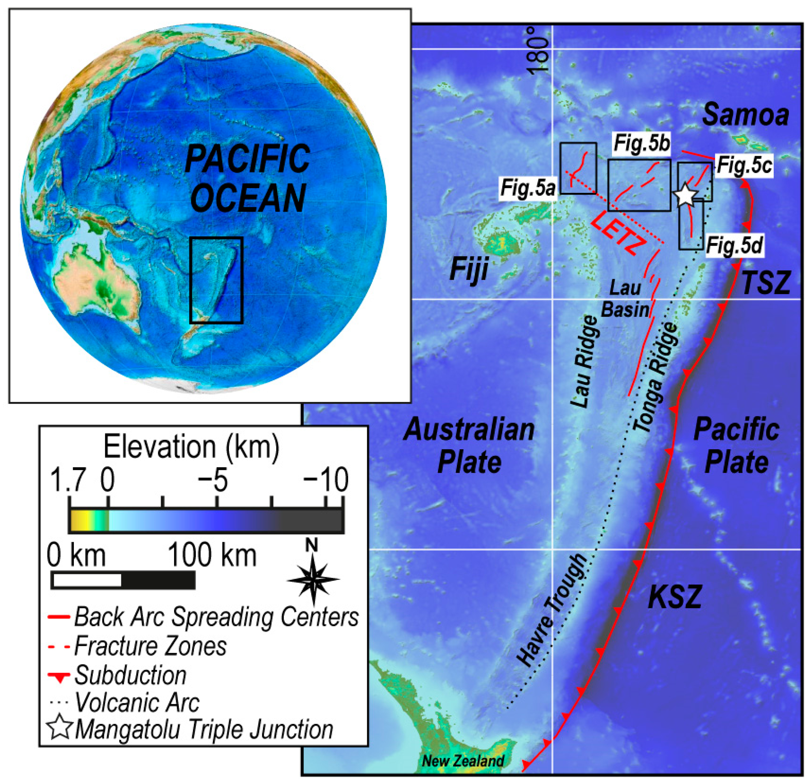
:1. Introduction
2. Materials and Methods
2.1. Bathymetry and Morphological Analysis
2.2. Magnetic Data
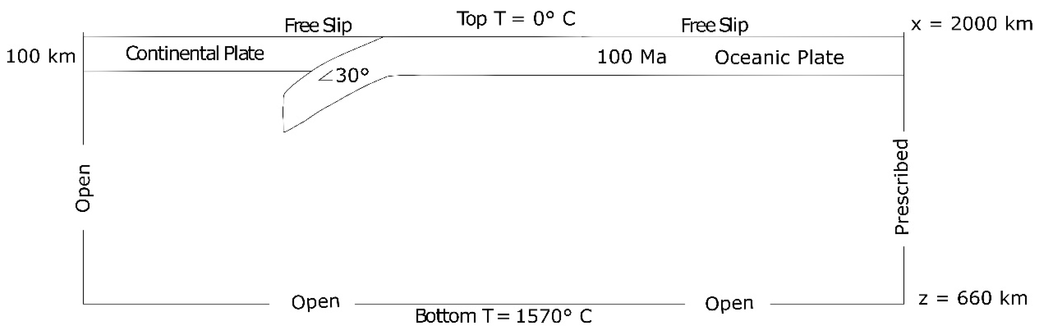
2.3. Numerical Model
3. Results
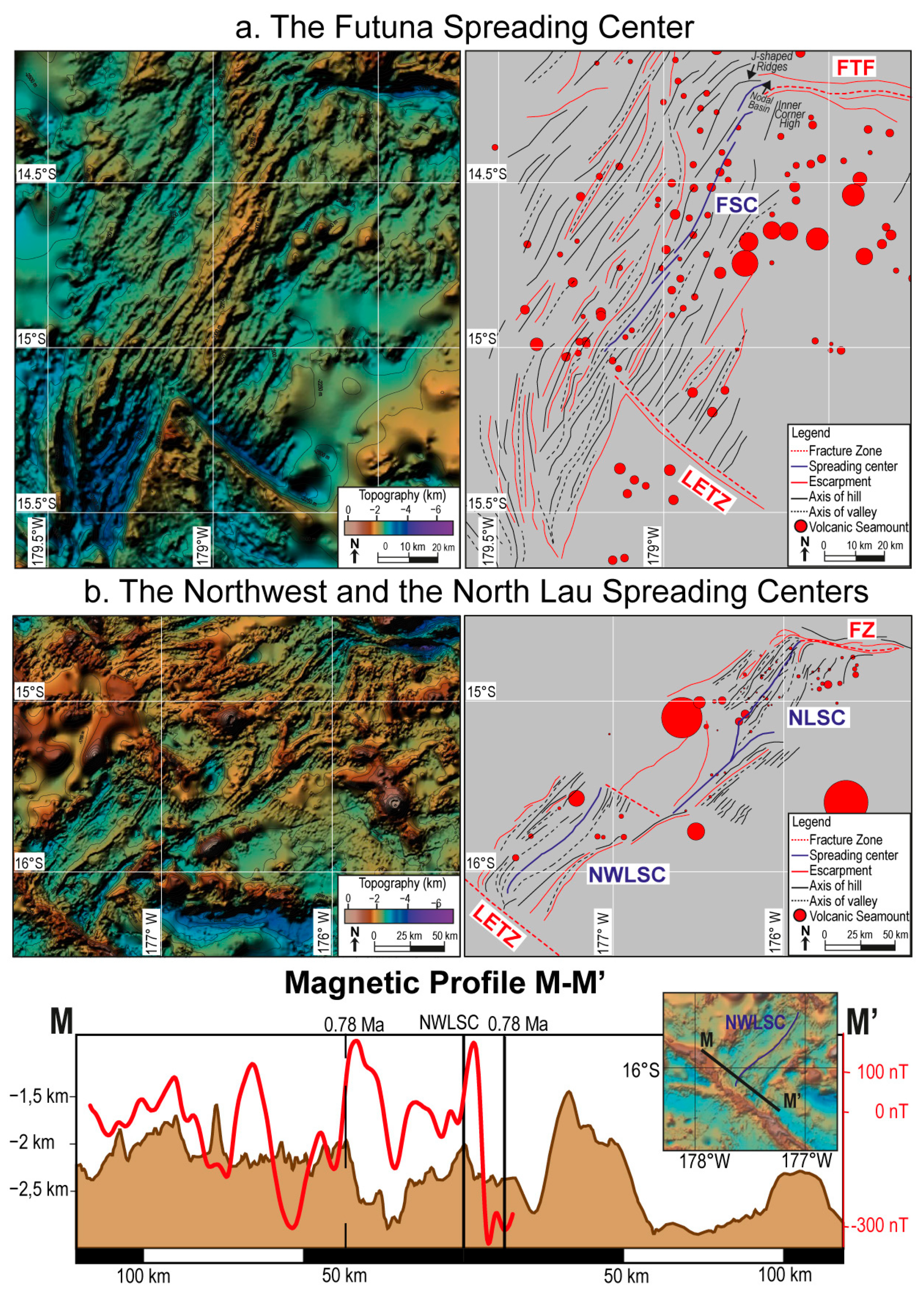
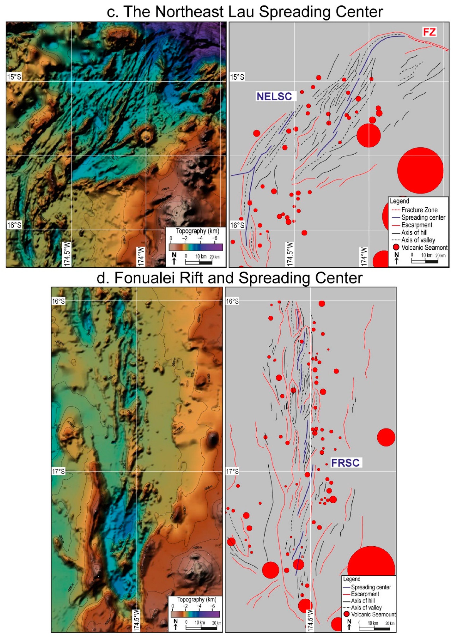
3.1. Morphological and Magnetic Analysis
3.2. Numerical Models
4. Discussion
5. Conclusions
Author Contributions
Funding
Data Availability Statement
Acknowledgments
Conflicts of Interest
References
- Crameri, F.; Conrad, C.P.; Montési, L.; Lithfow-Bertelloni, C.R. The dynamic life of an oceanic plate. Tectonophysics 2019, 760, 107–135. [Google Scholar] [CrossRef] [Green Version]
- Vine, F.J.; Matthews, D.H. Magnetic Anomalies over Oceanic Ridges. Nature 1963, 199, 949. [Google Scholar] [CrossRef]
- Parson, B.; Sclater, J.G. An analysis of the variation of ocean floor bathymetry and heat flow with age. J. Geophys. Res. 1977, 82, 803–827. [Google Scholar] [CrossRef]
- Hynes, A.; Mott, J. On the causes of back-arc spreading. Geology 1985, 13, 387–389. [Google Scholar] [CrossRef]
- Uyeda, S.; Kanamori, H. Back-arc opening and the mode of subduction. J. Geophys. Res. 1979, 84, 1049–1061. [Google Scholar] [CrossRef] [Green Version]
- Doglioni, C.; Gueguen, E.; Harabaglia, P.; Mongelli, F. On the origin of west-directed subduction zones and applications to the western Mediterranean. Geol. Soc. Lond. Spec. Publ. 1999, 156, 541–561. [Google Scholar] [CrossRef]
- Leat, P.T.; Larter, R.D. Intra-oceanic subduction systems: Introduction. Geol. Soc. Lond. Spec. Publ. 2003, 219, 1–17. [Google Scholar] [CrossRef]
- Sdrolias, M.; Muller, R.D. Controls on back-arc basin formation. Geochem. Geophys. Geosyst. 2006, 7, 1–40. [Google Scholar] [CrossRef]
- Greve, S.; Paulssen, H.; Goes, S.; Van Bergen, M. Shear-velocity structure of the Tyrrhenian Sea: Tectonics, volcanism and mantle (de) hydration of a back-arc basin. Earth Planet. Sci. Lett. 2014, 400, 45–53. [Google Scholar] [CrossRef] [Green Version]
- Marcuson, R.; Blackman, D.K.; Harmon, N. Seismic anisotropy predicted for 2-D plate-driven flow in the Lau back—Arc basin. Phys. Earth Planet. Int. 2014, 233, 88–94. [Google Scholar] [CrossRef]
- Perfit, M.R.; Chadwick, W.W. Magmatism at mid-ocean ridges: Constraints from volcanological and geochemical investigations. Geophys. Monogr.-Am. Geophys. Union 1998, 106, 59–116. [Google Scholar]
- Small, C. Faulting and Magmatism at Mid-Ocean Ridges; Buck, W., Delaney, P.T., Karson, J.A., Lagabrielle, Y., Eds.; American Geophysical Union: Washington, DC, USA, 1998; pp. 1–26. [Google Scholar]
- Dick, H.J.B.; Lin, L.; Schouten, H. An ultraslow-spreading class of ocean ridge. Nature 2003, 426, 405–412. [Google Scholar] [CrossRef]
- Magni, V. The effects of back-arc spreading on arc magmatism. Earth Planet. Sci. Lett. 2019, 519, 141–151. [Google Scholar] [CrossRef]
- Van der Broek, J.M.; Magni, V.; Gaina, C.; Biuter, S.J.H. The Formation of Continental Fragments in Subduction Settings: The Importance of Structural Inheritance and Subduction System Dynamics. J. Geophys. Res. Solid Earth 2019, 125, e2019JB018370. [Google Scholar]
- Zellmer, K.E.; Taylor, B. A three-plate kinematic model for the Lau Basin Opening. Geochem. Geophys. Geosyst. 2003, 2, 2000GC000106. [Google Scholar] [CrossRef]
- Karig, D.E.; Anderson, R.N.; Bibee, L.T. Characteristics of back arc spreading in the Mariana Trough. J. Geophys. Res. Solid Earth 1978, 83, 1213–1226. [Google Scholar] [CrossRef]
- Weissel, J.K. Magnetic lineations in marginal basins of the western Pacific. Philos. Trans. R. Soc. Lond. Ser. A Math. Phys. Sci. 1981, 300, 223–247. [Google Scholar]
- Parson, L.M.; Hawkins, J.W. Two-stage ridge propagation and the geological history of the Lau backarc basin. Proc. Ocean Drill. Program Sci. Results 1994, 135, 819–828. [Google Scholar]
- Heezen, B.C.; Johnson, G.L. The South Sandwich Trench. Deep-Sea Res. 1965, 12, 185–197. [Google Scholar] [CrossRef]
- Livermore, R.; Cunningham, A.; Vanneste, L.; Larter, R. Subduction influence on magma supply at the East Scotia Ridge. Earth Planet. Sci. Lett. 1997, 150, 261–275. [Google Scholar] [CrossRef]
- Karig, D.E. Ridges and Basins of the Tonga-Kermadec Island Arc System. J. Geophys. Res. 1970, 75, 239–254. [Google Scholar] [CrossRef]
- Martinez, F.; Taylor, B. Mantle wedge control on back-arc crustal accretion. Nature 2002, 416, 417–420. [Google Scholar] [CrossRef]
- Weissel, J.K.; Hayes, D.E.; Herron, E.M. Plate tectonics synthesis: The displacements between Australia, New Zealand, and Antarctica since the Late Cretaceous. Mar. Geol. 1977, 25, 231–277. [Google Scholar] [CrossRef]
- Malahoff, A.; Feden, R.H.; Fleming, H.S. Magnetic anomalies and tectonic fabric of marginal basins north of New Zealand. J. Geophys. Res. 1982, 87, 4109–4125. [Google Scholar] [CrossRef]
- Taylor, B.; Zellmer, K.; Martinez, F.; Goodlie, A. Seafloor spreading in the Lau back-arc basin. Earth Planet. Sci. Lett. 1996, 144, 35–40. [Google Scholar] [CrossRef]
- Parson, L.M.; Wright, I.C. The Lau-Havre-Taupo back-arc basin: A southward-propagating, milti-stage evolution from rifting to spreading. Tectonophysics 1996, 263, 1–22. [Google Scholar] [CrossRef]
- Fujiwara, T.; Yamazaki, T.; Joshima, M. Bathymetry and magnetic anomalies in the Havre Trough and southern Lau Basin: From rifting to spreading in back-arc basins. Earth Planet. Sci. Rev. 2001, 185, 253–264. [Google Scholar] [CrossRef]
- Ruellan, E.; Delteil, J.; Wright, I.; Matsumoto, T. From rifting to active spreading in the Lau Basin—Havre Trough backarc system (SW Pacific)—Locking/unlocking induced by seamount chain subduction. Geochem. Geophys. Geosyst. 2006, 4. [Google Scholar] [CrossRef] [Green Version]
- Caratori Tontini, F.; Bassett, D.; De Ronde, C.E.J.; Timm, C.; Wysoczanski, R. Early evolution of a young back-arc basin in the Havre Trough. Nat. Geosci. 2019, 12, 856–862. [Google Scholar] [CrossRef] [Green Version]
- Bevis, M.; Taylor, F.W.; Schutz, B.E.; Recy, J.; Isacks, B.L.; Helu, S.; Calmantli, S. Geodetic observations of very rapid convergence and back-arc extension at the Tonga arc. Nature 1995, 374, 249–251. [Google Scholar] [CrossRef]
- Dziewonski, A.M.; Chou, T.A.; Woodhouse, J.H. Determination of earthquake source parameters from waveform data for studies of global and regional seismicity. J. Geophys. Res. 1981, 86, 2825–2852. [Google Scholar] [CrossRef]
- Ekstrom, G.; Nettles, M.; Dziewonski, A.M. The global CMT project 2004-2010: Centroid moment tensors for 13,017 earthquakes. Phys. Earth Planet. Int. 2012, 200, 1–9. [Google Scholar] [CrossRef]
- Wessel, P.; Smith, W.H.; Scharroo, R.; Luis, J.; Wobbe, F. Generic mapping tools: Improved version released. Eos Trans. Am. Geophys. Union 2013, 94, 409–410. [Google Scholar] [CrossRef] [Green Version]
- Crameri, F.; Shepard, G.E.; Heron, P.J. The misuse of colour in science communication. Nat. Commun. 2020, 11, 5444. [Google Scholar] [CrossRef]
- De Mets, C.; Gordon, R.G.; Argus, D.F. Geologically current plate motions. Geophys. J. Int. 2010, 181, 1–80. [Google Scholar] [CrossRef] [Green Version]
- Müller, R.D.; Zahirovic, S.; Williams, S.E.; Cannon, J.; Seton, M.; Bower, D.J.; Tetley, M.G.; Heine, C.; Le Breton, E.; Liu, S.; et al. A global plate model including lithospheric deformation along major rifts and orogens since the Triassic. Tectonics 2019, 38, 1884–1907. [Google Scholar] [CrossRef] [Green Version]
- Baxter, A.T.; Hannington, M.D.; Stewart, M.S.; Emberley, J.M.; Brejer, K.; Kratschell, A.; Petersen, S.; Brandl, P.A.; Klischies, M.; Mensing, R.; et al. Shallow Seismicity and the Classification of Structures in the Lau Back-Arc Basin. Geochem. Geophys. Geosyst. 2020, 21, e2020GC008924. [Google Scholar] [CrossRef] [Green Version]
- Baker, E.T.; Sharon, L.W.; Massoth, G.J.; Resing, J.A. The NE Lau Nasin: Widespread and Abundant Hydrothermal Venting in Back-Arc Region behind a Superfast Subduction Zone. Front. Mar. Sci. 2019, 6, 382. [Google Scholar] [CrossRef]
- Segev, A.; Rybakov, M.; Mortimer, N. A crustal model for Zoelandia and Fiji. Geophys. J. Int. 2012, 189, 1277–1292. [Google Scholar] [CrossRef] [Green Version]
- Sleeper, J.D.; Martinez, F.; Arculus, R. The Fonualei rift and spreading Center: Effects of ultraslow spreading and arc proximity on back-arc crustal accretion. J. Geophys. Res. Solid Earth 2016, 121, 4814–4835. [Google Scholar] [CrossRef]
- Van de Lagemaat, S.H.A.; Van Hinsbergen, D.J.J.; Boschman, L.M.; Kamp, P.J.J.; Spakman, W. Southwest Pacific absolute plate kinematic reconstruction reveals major Cenozoic Tonga-Kermadec slab dragging. Tectonics 2018, 37, 2647–2674. [Google Scholar] [CrossRef]
- Seton, M.; Müller, R.D.; Zahirovic, S.; Gaina, C.; Torsvik, T.; Shephard, G. Global continental and ocean basin reconstructions since 200 Ma. Earth-Sci. Rev. 2012, 113, 212–270. [Google Scholar] [CrossRef] [Green Version]
- Garel, E.; Lagabrielle, Y.; Pelletier, B. Abrupt axial variations along the slow to ultra-slow spreading centers of the northern North Fiji Basin (SW Pacific): Evidence for short wave heterogeneities in a back-arc mantle. Mar. Geophys. Res. 2003, 24, 245–263. [Google Scholar] [CrossRef]
- Szitkar, F.; Dyment, J.; Fouquet, Y. Widespread volcanism Southeast of Futuna Island (SW Pacific Ocean): Near-seafloor magnetic dating and regional consequences. J. Volcanol. Geotherm. Res. 2020, 406, 107064. [Google Scholar] [CrossRef]
- Lytle, M.L.; Kelley, K.A.; Hauri, E.H.; Gill, J.B.; Papia, D.; Arculus, R.J. Tracing mantle sources and Samoan influence in the northwestern Lau back-arc basin. Geochem. Geophys. Geosyst. 2012, 13, Q10019. [Google Scholar] [CrossRef] [Green Version]
- Anderson, M.O.; Norris-Julseth, C.; Rubin, K.H.; Haase, K.; Hannington, M.D.; Baxter, A.T.; Stewart, M.S. Geologic and Structural Evolution of the NE Lau Basin, Tonga: Morphotectonic Analysis and Classification of Structures Using Shallow Seismicity. Front. Front. Earth Sci. 2021, 9, 665185. [Google Scholar] [CrossRef]
- Wilson, J.Y. A new class of faults and their bearing on continental drifts. Nature 1965, 207, 343–347. [Google Scholar] [CrossRef]
- Sykes, L.R. Mechanism of earthquakes and nature of faulting on the Mid-Atlantic Ridge. J. Geoph. Res. 1967, 72, 2131–2153. [Google Scholar] [CrossRef] [Green Version]
- Fox, J.P.; Gallo, G. A tectonic model for Ridge-Transform–Ridge plate boundaries: Implications for the structure of oceanic lithosphere. Tectonophysics 1984, 104, 205–242. [Google Scholar] [CrossRef]
- Smith, D.K.; Cann, J.R. Building the crust at the Mid-Atlantic Ridge. Nature 1993, 365, 707–715. [Google Scholar] [CrossRef]
- Escartin, J.; Cannat, M. Ultramafic exposures and the gravity signature of the lithosphere near the Fifteen-Twenty Fracture Zone (Mid-Atlantic Ridge, 14°–16.5°N). Earth Planet. Sci. Lett. 1999, 171, 411–424. [Google Scholar] [CrossRef]
- Rundquist, D.V.; Sobolev, P.O. Seismicity of mid-oceanic ridges and its geodynamic implications: A review. Earth-Sci. Rev. 2002, 58, 143–161. [Google Scholar] [CrossRef]
- Smith, D.K.; Escartín, J.; Cannat, M.; Tolstoy, M.; Fox, C.G.; Bohnenstiehl, D.R.; Bazin, R. Spatial and temporal distribution of seismicity along the northern Mid-Atlantic Ridge (15°–35°N). J. Geoph. Res. 2003, 108, 8-1–8-22. [Google Scholar] [CrossRef]
- Harris, P.T.; Macmillian-Lawler, M.; Rupp, J.; Baker, E.K. Geomorphology of the oceans. Mar. Geol. 2014, 352, 4–24. [Google Scholar] [CrossRef]
- National Geophysical Data Center (NOAA). Marine Trackline Geophysical Database. 1977. Available online: https://www.ncei.noaa.gov/access/metadata/landing-page/bin/iso?id=gov.noaa.ngdc:G00129 (accessed on 12 December 2021).
- Thébault, E.; Finlay, C.C.; Beggan, C.D. International Geomagnetic Reference Field: The 12th generation. Earth Planet. Sp. 2015, 67, 79. [Google Scholar]
- Mendel, V.; Munschy, M.; Sauter, D. MODMAG, a MATLAB program to model marine magnetic anomalies. Comp. Geosci. 2005, 31, 589–597. [Google Scholar] [CrossRef]
- Cande, S.C.; Kent, D.V. Revised calibration of the geomagnetic polarity time scale for the Late Cretaceous and Cenozoic. J. Geophys. Res. 1995, 100, 6093–6095. [Google Scholar] [CrossRef] [Green Version]
- Kronbichler, M.; Heister, T.; Bangerth, W. High Accuracy Mantle Convection Simulation through Modern Numerical Methods. Geophys. J. Int. 2012, 191, 12–29. [Google Scholar] [CrossRef] [Green Version]
- Heister, T.; Dannberg, J.; Gassmöller, R.; Bangerth, W. High Accuracy Mantle Convection Simulation through Modern Numerical Methods—II: Realistic Models and Problems. Geophys. J. Int. 2017, 210, 833–851. [Google Scholar] [CrossRef]
- Bangerth, W.; Dannberg, J.; Gassmoeller, R.; Heister, T. ASPECT v2.2.0. (Version v2.2.0). Zenodo. 2020. Available online: https://zenodo.org/record/3924604#.YegJmvgRVPY (accessed on 12 December 2021).
- Schubert, G.; Turcotte, D.L.; Olson, P. Mantle Convection in the Earth and Planets; Part 1; Cambridge University Press: Cambridge, UK, 2001. [Google Scholar]
- Glerum, A.; Thieulot, C.; Frater, M.; Blom, C.; Spakman, W. Nonlinear viscoplasticity in ASPECT: Benchmarking and applications to subduction. Solid Earth 2018, 9, 267–294. [Google Scholar] [CrossRef] [Green Version]
- Gerya, T. Introduction to Numerical Geodynamic Modelling; Cambridge University Press: Cambridge, UK, 2010. [Google Scholar]
- Ficini, E.; Cuffaro, M.; Doglioni, C. Asymmetric dynamics at subduction zones derived from plate kinematic constraints. Gondwana Res. 2020, 78, 110–125. [Google Scholar] [CrossRef]
- Doglioni, C.; Carminati, E.; Cuffaro, M.; Scrocca, D. Subduction kinematics and dynamic constraints. Earth Sci. Rev. 2007, 83, 125–175. [Google Scholar] [CrossRef]
- Müller, R.D.; Sdrolias, M.; Gaina, C.; Roest, W.R. Age, spreading rates, and spreading asymmetry of the world’s ocean crust. Geochem. Geophys. Geosyst. 2008, 9, Q04006. [Google Scholar] [CrossRef]
- Müller, R.D.; Seton, M.; Zahirovic, S.; Williams, S.E.; Matthews, K.J.; Wright, N.M.; Shephard, G.E.; Maloney, K.T.; Barnett-Moore, N.; Hosseinpour, M.; et al. Ocean basin evolution and global-scale plate reorganization events since Pangea breakup. Ann. Rev. Earth Planet. Sci. 2016, 44, 107–138. [Google Scholar] [CrossRef]
- Vérard, C.; Stamfli, G.M. Geodynamic reconstructions of the Australides-2: Mesozoic-Cainozoic. Geosciences 2013, 3, 331–353. [Google Scholar] [CrossRef] [Green Version]
- Ribeiro, J.M.; Stern, R.J.; Martinez, F.; Woodhead, J.; Chen, M.; Ohara, Y. Asthenospheric outflow from the shrinking Philippine Sea Plate: Evidence from HfeNd isotopes of southern Mariana lavas. Earth Planet. Sci. Lett. 2017, 478, 258–271. [Google Scholar] [CrossRef]
- Ranalli, G. Rheology of the Earth, 2nd ed.; Chapman Hall: London, UK, 1995. [Google Scholar]
- Clauser, C.; Huenges, E. Thermal conductivity of rocks and minerals. In Rock Physics and Phase Relations; Ahrens, T.J., Ed.; Reference Shelf 3; AGU: Washington DC, USA, 1995; pp. 105–126. [Google Scholar]
- Mallard, C.; Coltice, N.; Seton, M.; Müller, R.D.; Tackley, P.J. Subduction controls the distribution and fragmentation of Earth’s tectonic plates. Nature 2016, 535, 140–143. [Google Scholar] [CrossRef] [Green Version]
- Spiess, F.N.; Macdonald, K.C.; Atwater, T.; Ballard, R.; Carranza, A.; Cordoba, D.; Rangin, C. East Pacific Rise: Hot springs and geophysical experiments. Science 1980, 207, 1421–1433. [Google Scholar] [CrossRef]
- Fornari, D.J.; Von Damm, K.L.; Bryce, J.G.; Cowen, J.P.; Ferrini, V.; Fundis, A.; Adams, D.K. The East Pacific Rise between 9 N and 10 N: Twenty-five years of integrated, multidisciplinary oceanic spreading center studies. Oceanography 2012, 25, 18–43. [Google Scholar] [CrossRef]
- Grevemeyer, I.; Rüpke, L.H.; Morgan, J.P.; Iyer, K.; Devey, C.W. Extensional tectonics and two-stage crustal accretion at oceanic transform faults. Nature 2021, 591, 402–407. [Google Scholar] [CrossRef]
- Lupton, J.; Rubin, K.H.; Arculus, R.; Lilley, M.; Butterfield, D.; Resing, J.; Baker, E.; Embley, R. Helium isotope, C/3He, and Ba-Nb-Ti signatures in the northern Lau Basin: Distinguishing arc, back-arc, and hotspot affinities. Geochem. Geophys. Geosyst. 2020, 16, 1133–1155. [Google Scholar] [CrossRef] [Green Version]


| VH (mm/year) | Reference for VH | VL (mm/year) | Reference for VL | VS (mm/year) |
|---|---|---|---|---|
| 131.3 | [71] | 81.7 ± 0.8 | [36] | 213.0 |
| Overriding Plate | Subducting Plate | Mantle | |
|---|---|---|---|
| Reference density (kg/m3) | 3300 | 3300 | 3300 |
| Viscosity prefactors (dislocation creep) | 1 × 10⁻²⁰ | 1 × 10⁻²¹ | 5 × 10⁻³⁰ |
| Stress exponents | 3.5 | 3.5 | 1 |
| Thermal diffusivity (W/m K) | 1.3 × 10⁻⁶ | 1.3 × 10⁻⁶ | 1.3 × 10⁻⁶ |
| Thermal expansivity (1/K) | 2 × 10⁻⁵ | 2 × 10⁻⁵ | 2 × 10⁻⁵ |
| Heat capacity (J/kg K) | 1250 | 1250 | 1250 |
Publisher’s Note: MDPI stays neutral with regard to jurisdictional claims in published maps and institutional affiliations. |
© 2022 by the authors. Licensee MDPI, Basel, Switzerland. This article is an open access article distributed under the terms and conditions of the Creative Commons Attribution (CC BY) license (https://creativecommons.org/licenses/by/4.0/).
Share and Cite
Palmiotto, C.; Ficini, E.; Loreto, M.F.; Muccini, F.; Cuffaro, M. Back-Arc Spreading Centers and Superfast Subduction: The Case of the Northern Lau Basin (SW Pacific Ocean). Geosciences 2022, 12, 50. https://0-doi-org.brum.beds.ac.uk/10.3390/geosciences12020050
Palmiotto C, Ficini E, Loreto MF, Muccini F, Cuffaro M. Back-Arc Spreading Centers and Superfast Subduction: The Case of the Northern Lau Basin (SW Pacific Ocean). Geosciences. 2022; 12(2):50. https://0-doi-org.brum.beds.ac.uk/10.3390/geosciences12020050
Chicago/Turabian StylePalmiotto, Camilla, Eleonora Ficini, Maria Filomena Loreto, Filippo Muccini, and Marco Cuffaro. 2022. "Back-Arc Spreading Centers and Superfast Subduction: The Case of the Northern Lau Basin (SW Pacific Ocean)" Geosciences 12, no. 2: 50. https://0-doi-org.brum.beds.ac.uk/10.3390/geosciences12020050