
Transtension at the Northern Termination of the Alfeo-Etna Fault System (Western Ionian Sea, Italy): Seismotectonic Implications and Relation with Mt. Etna Volcanism

 , , , and
Abstract
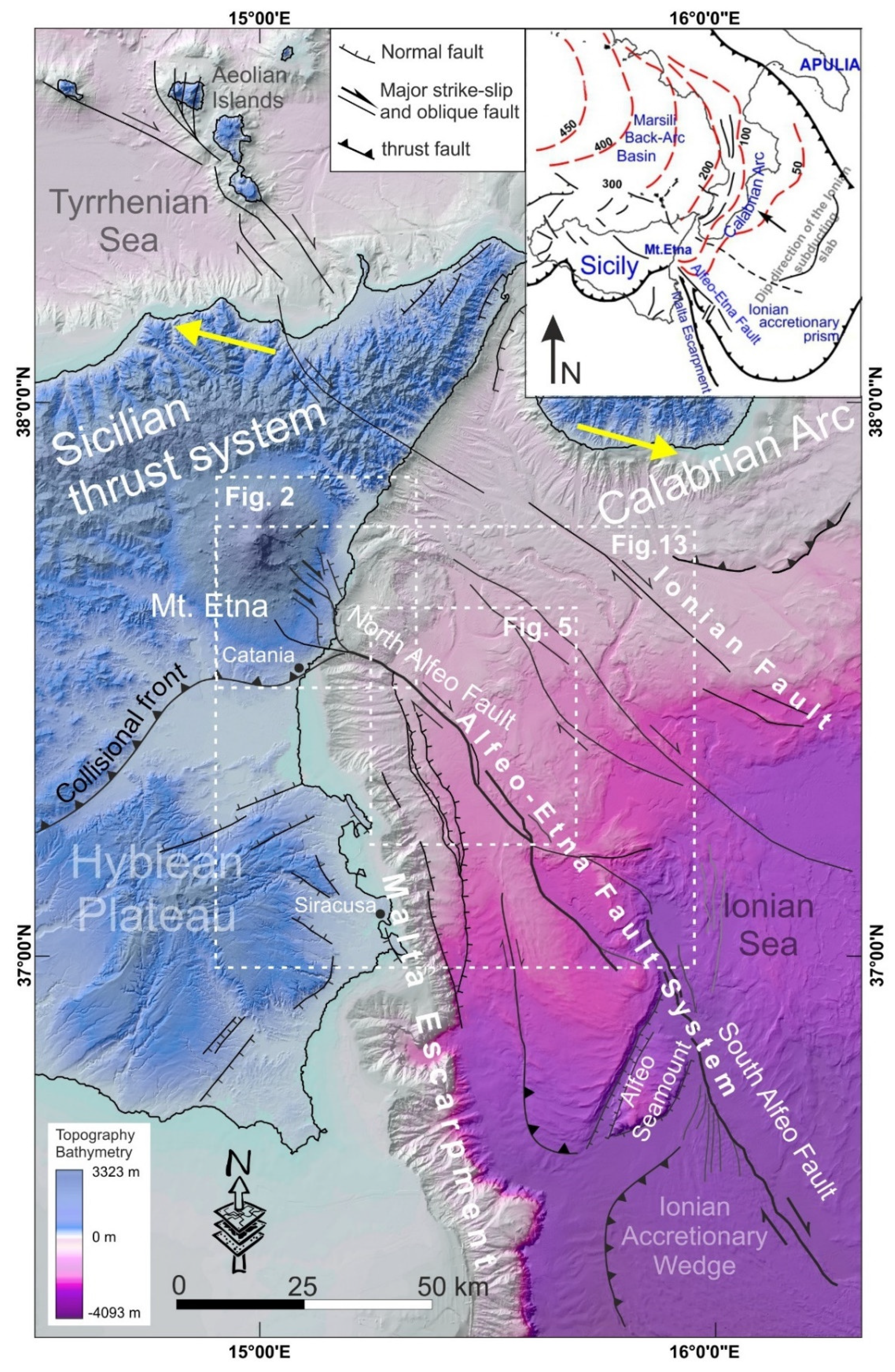
:1. Introduction
2. Geological Setting
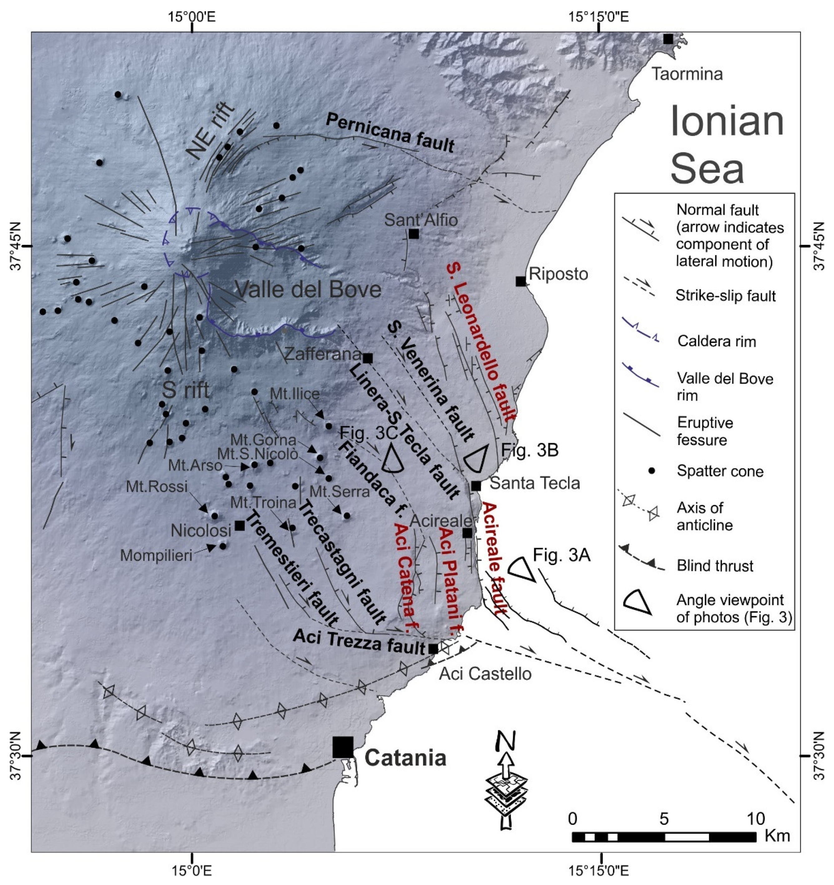
2.1. Mt. Etna Volcano
2.2. Alfeo-Etna Fault System
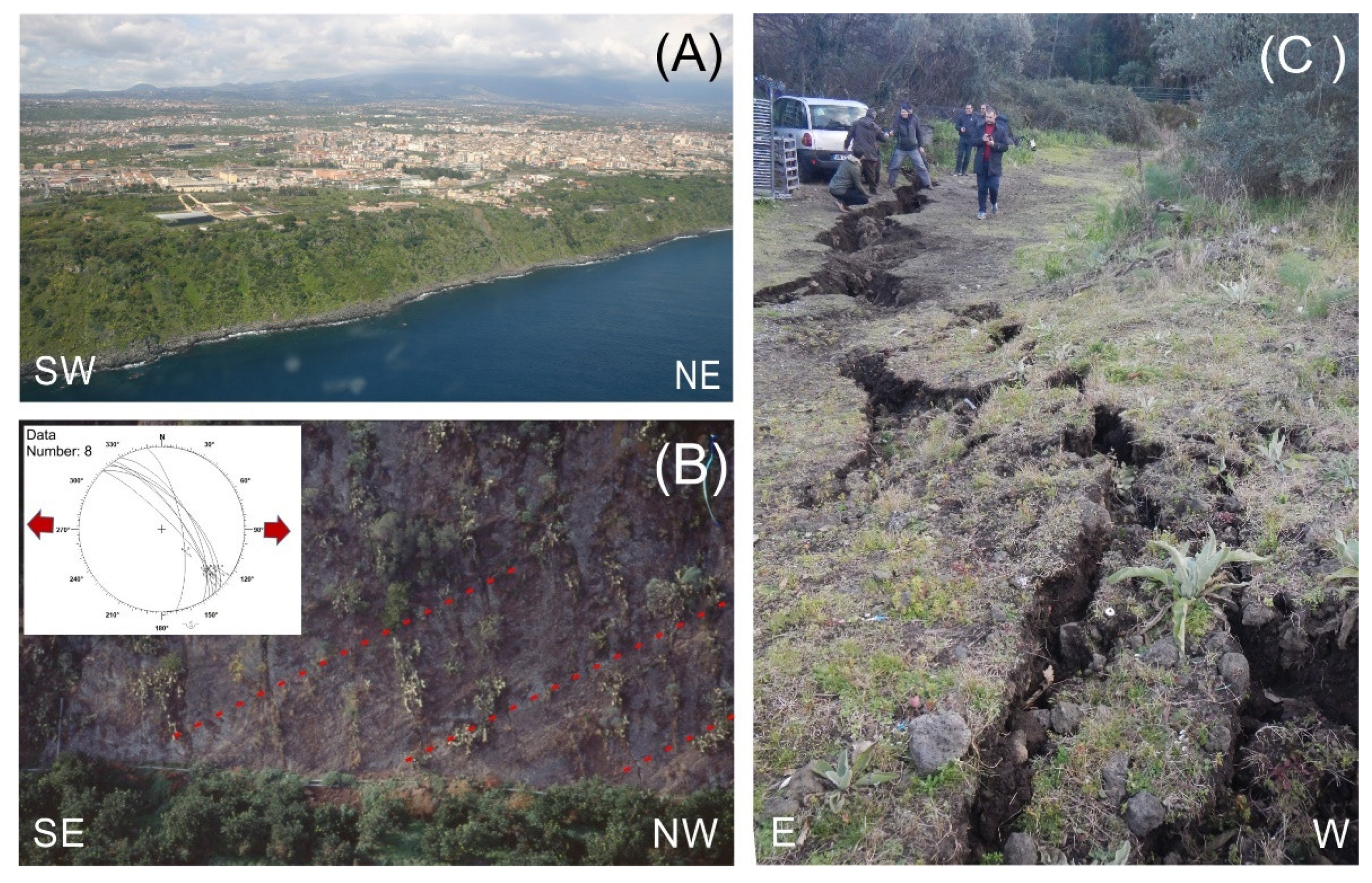
3. Tectonic Structures of the South-Eastern Sector of Mt. Etna
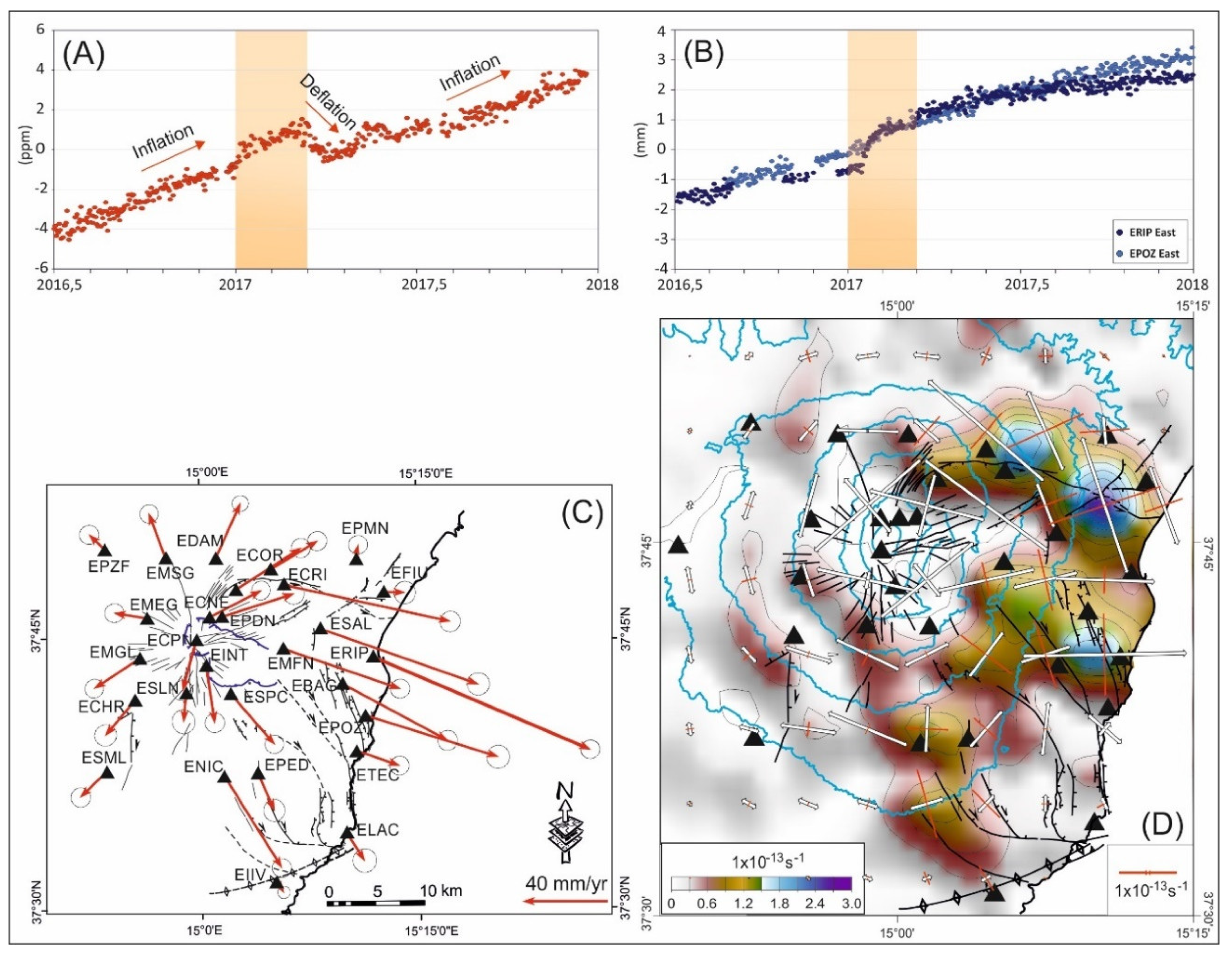
4. Geodetic Data
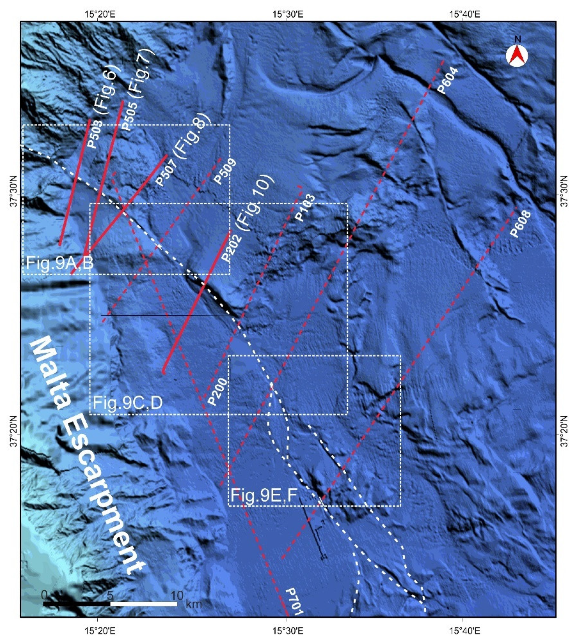
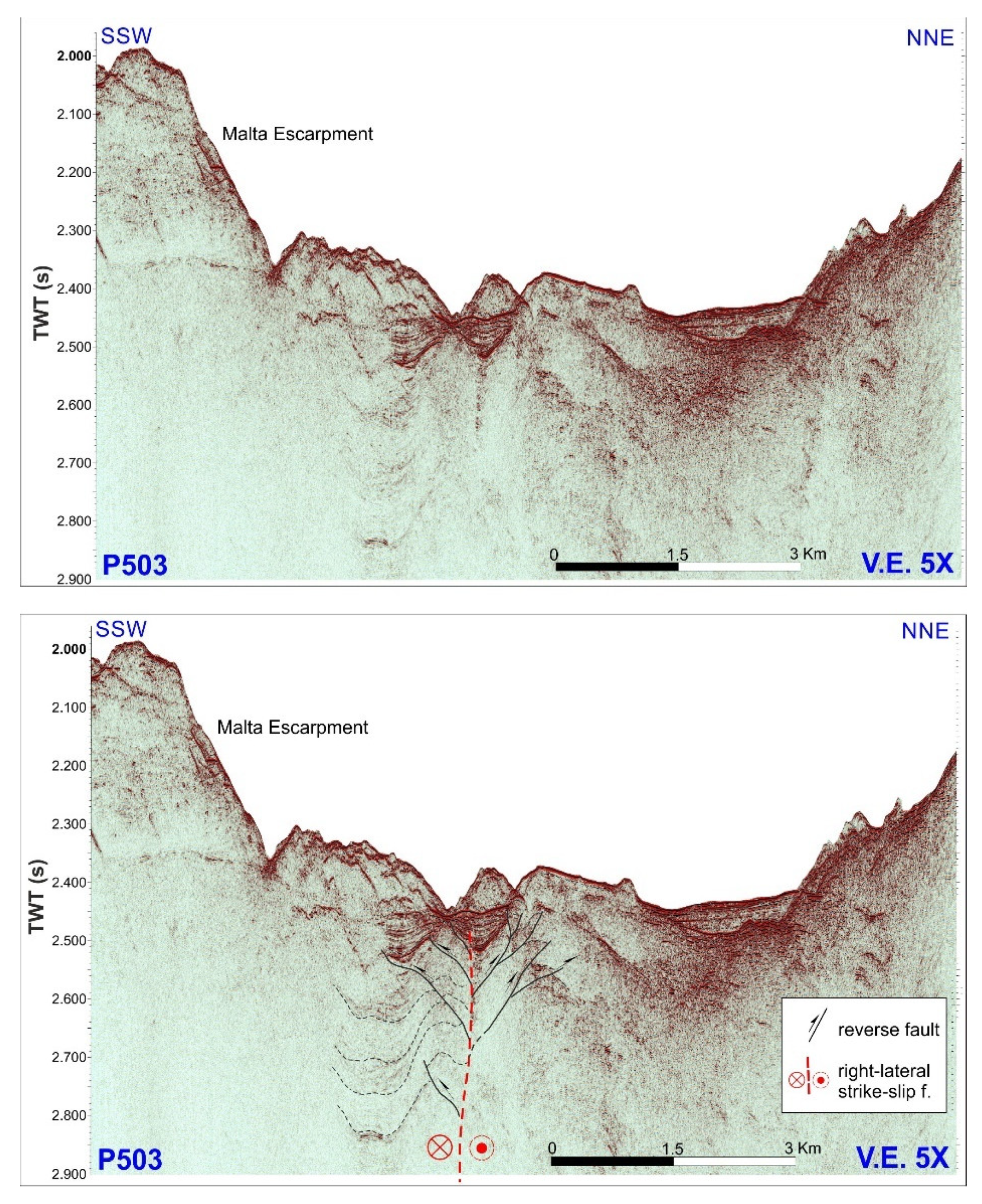
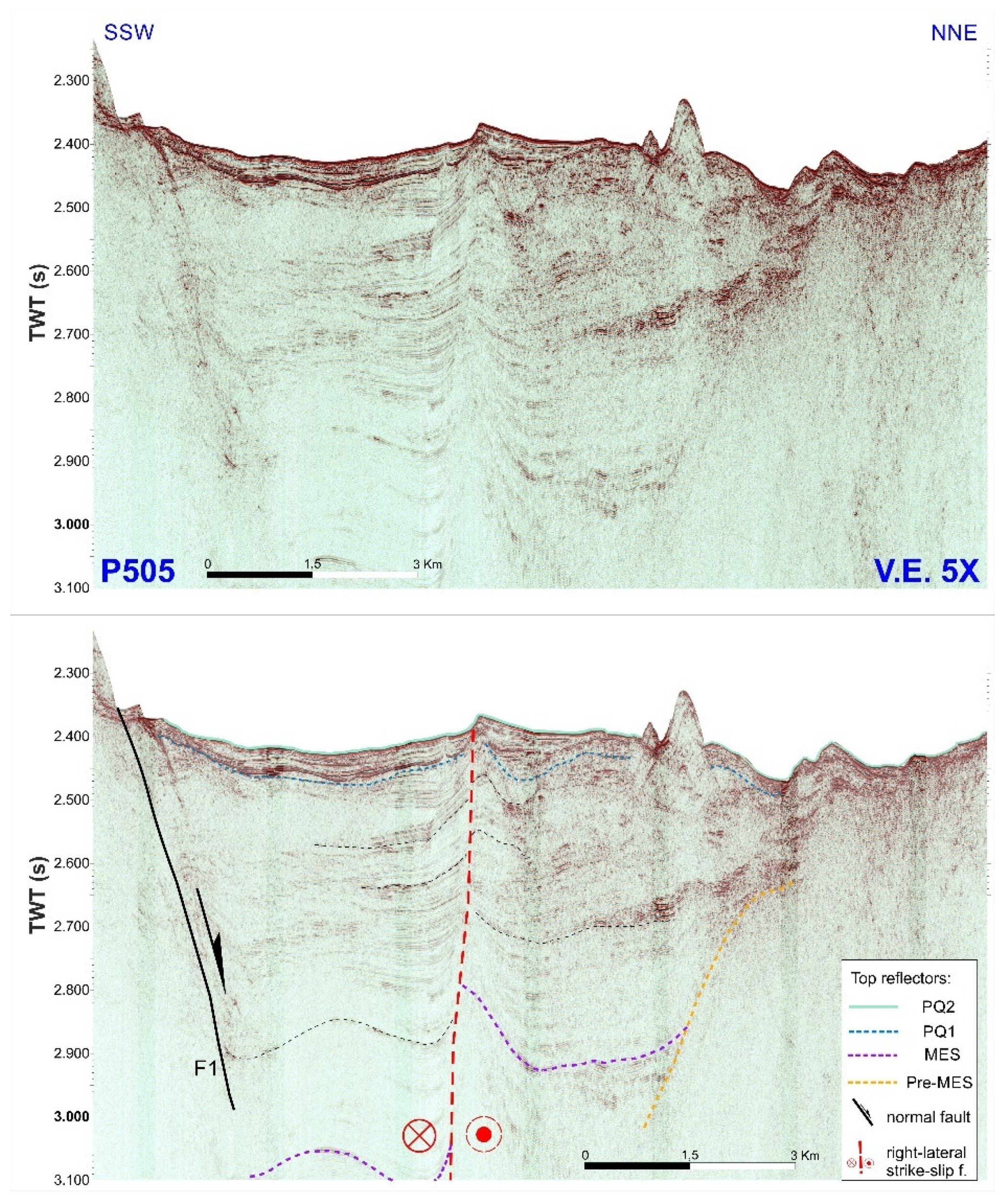
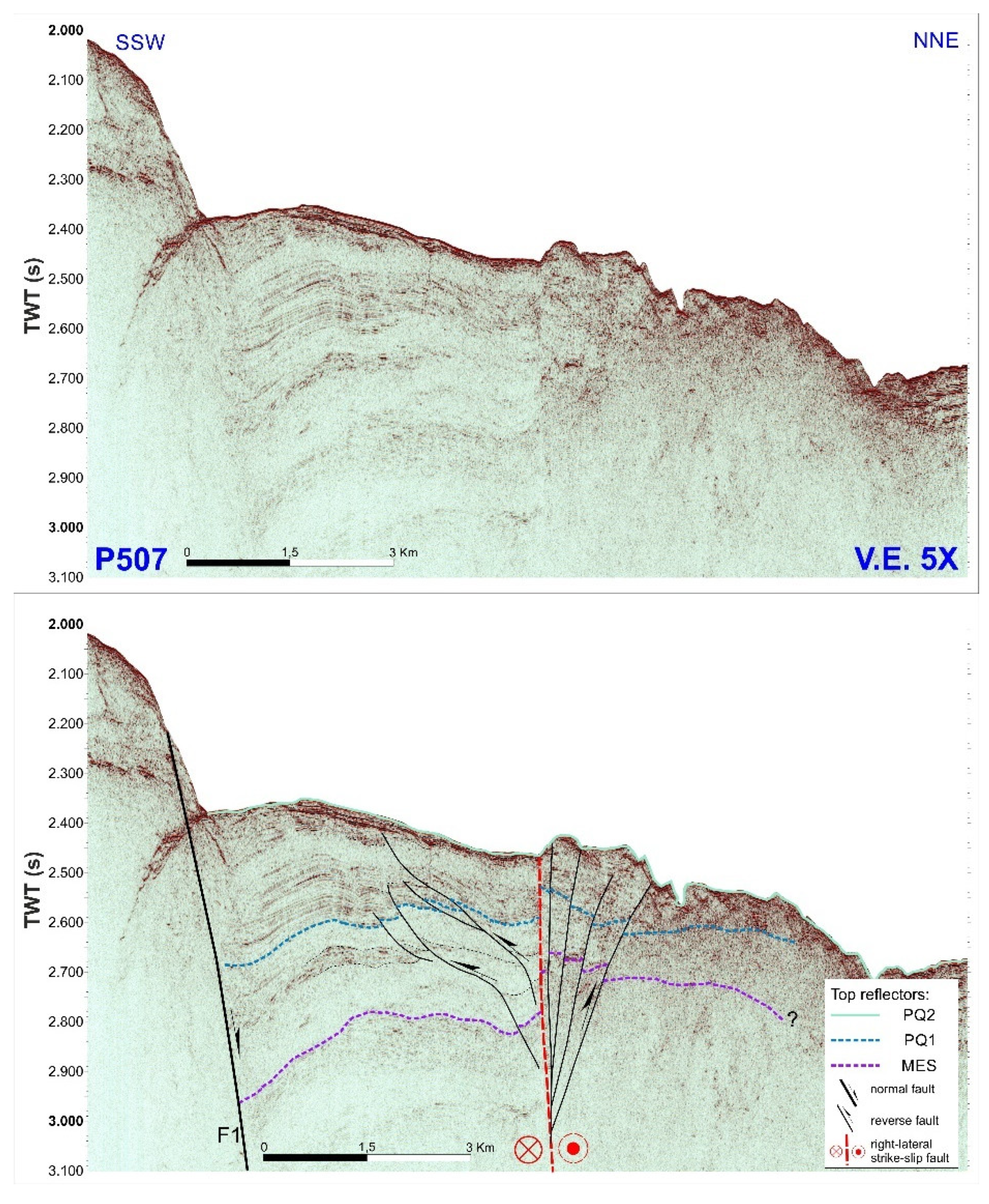
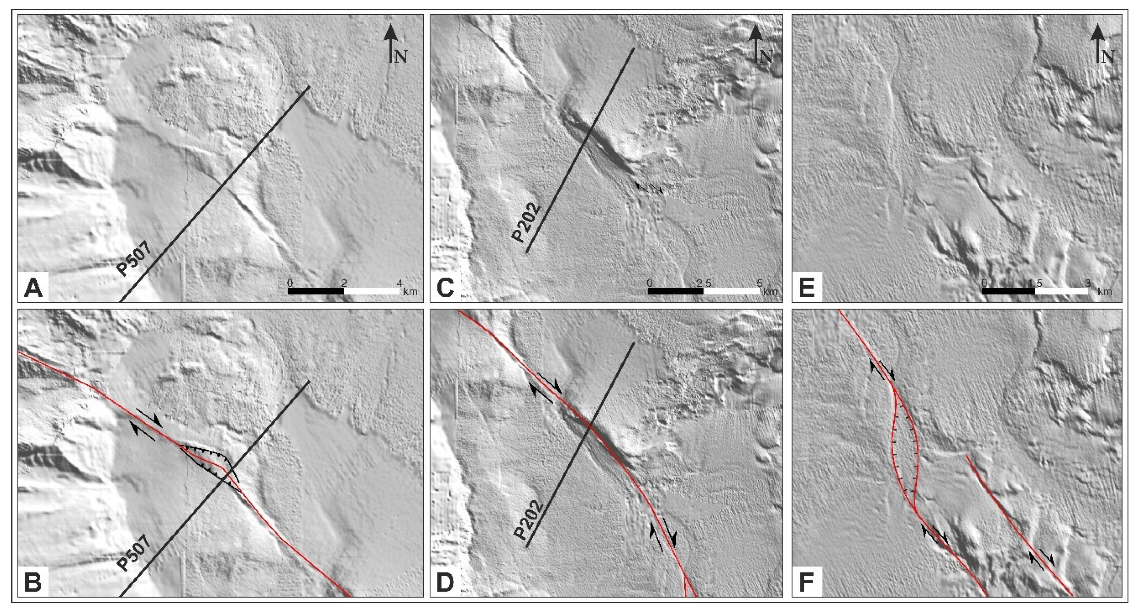
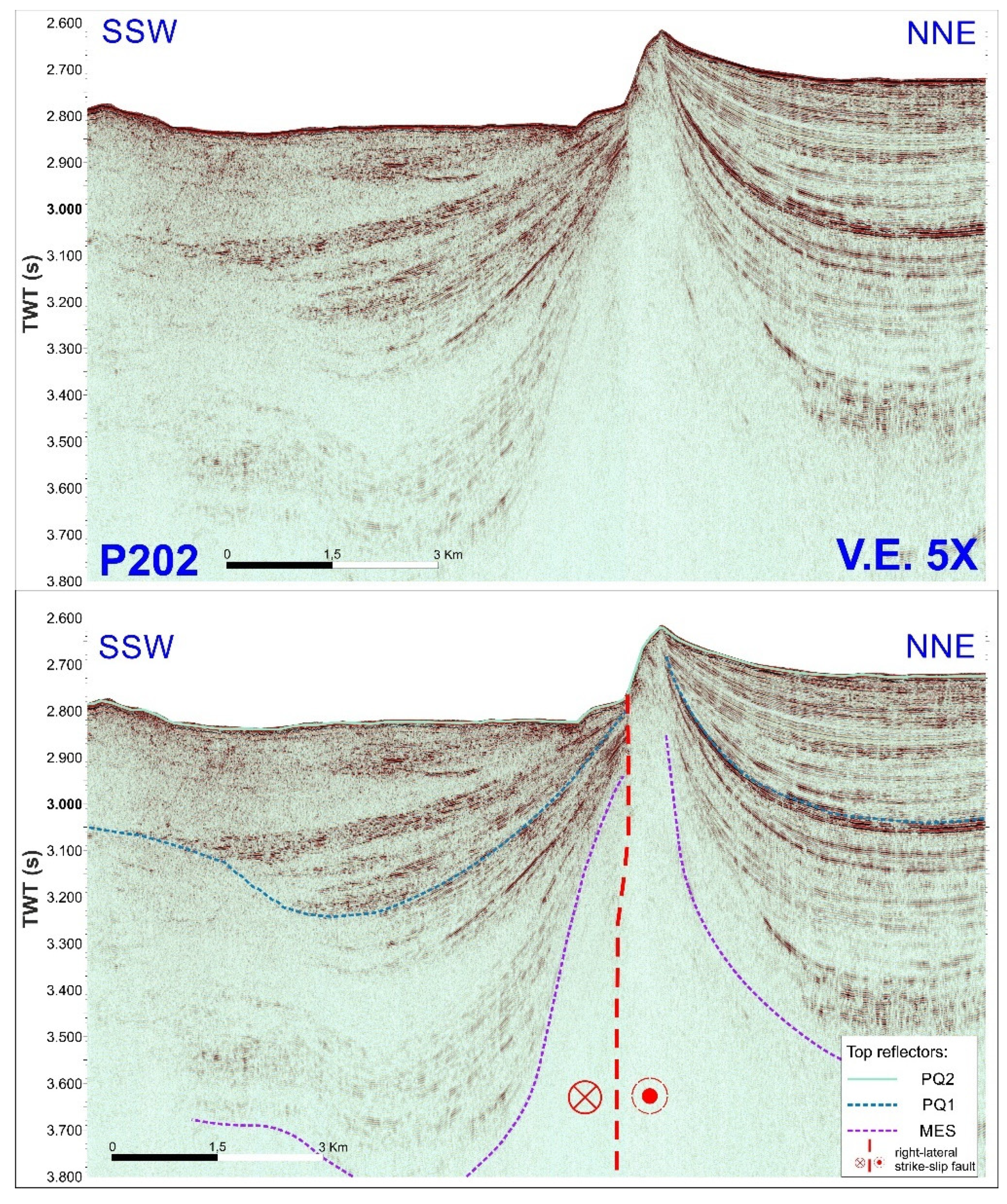
5. Marine Seismic Reflection Data
5.1. Data and Methods
5.2. The Offshore Tectonic Pattern
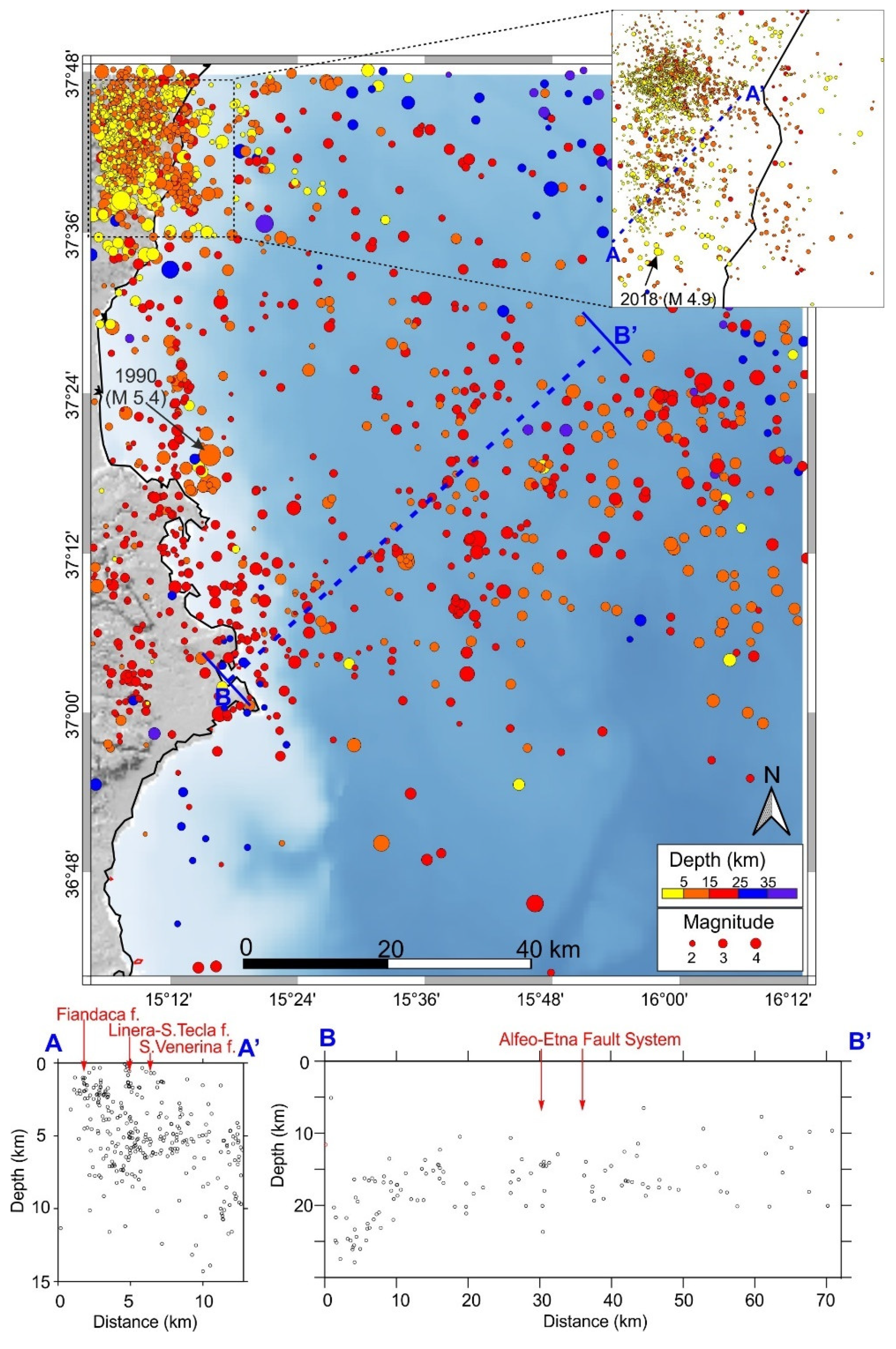
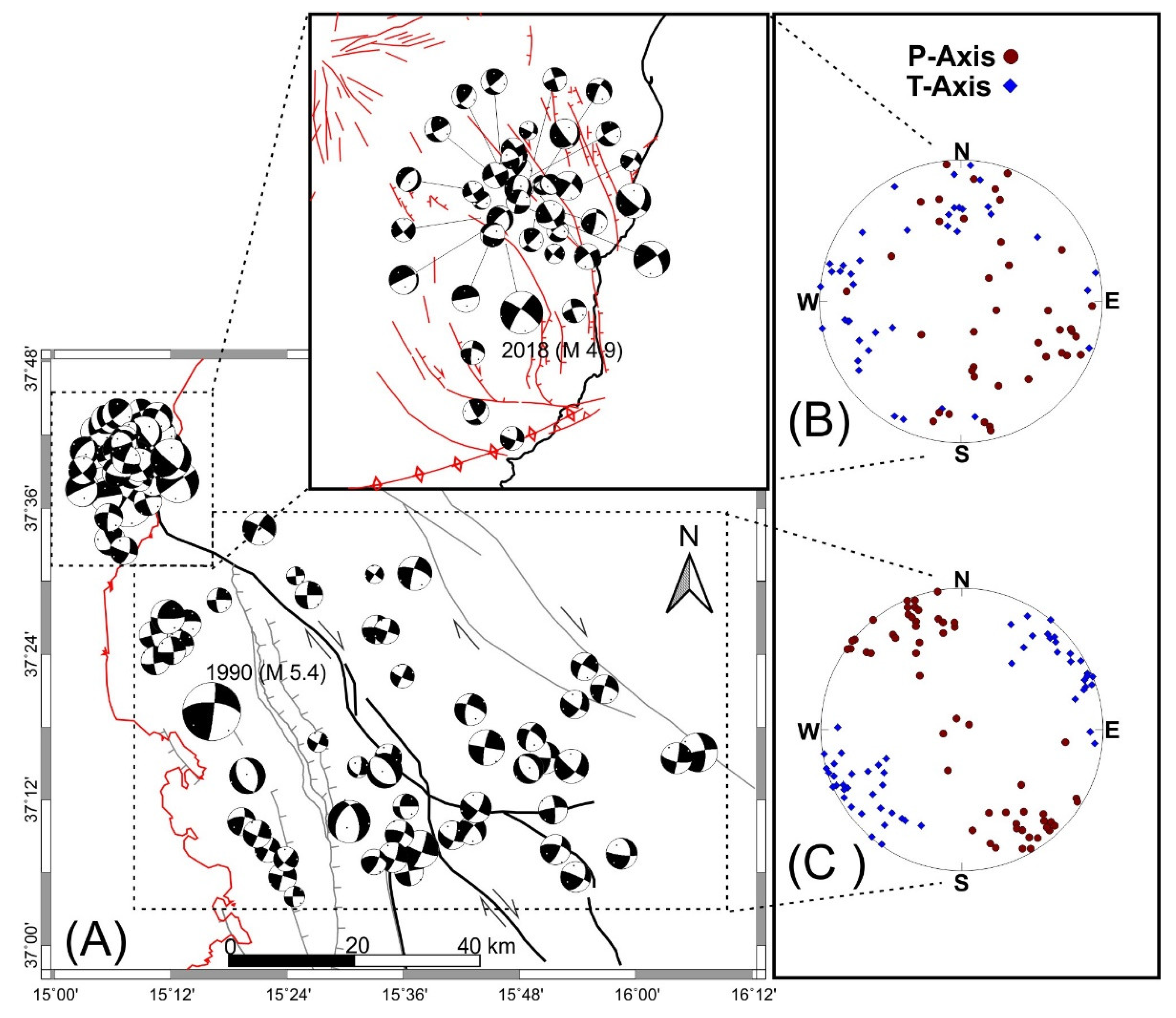
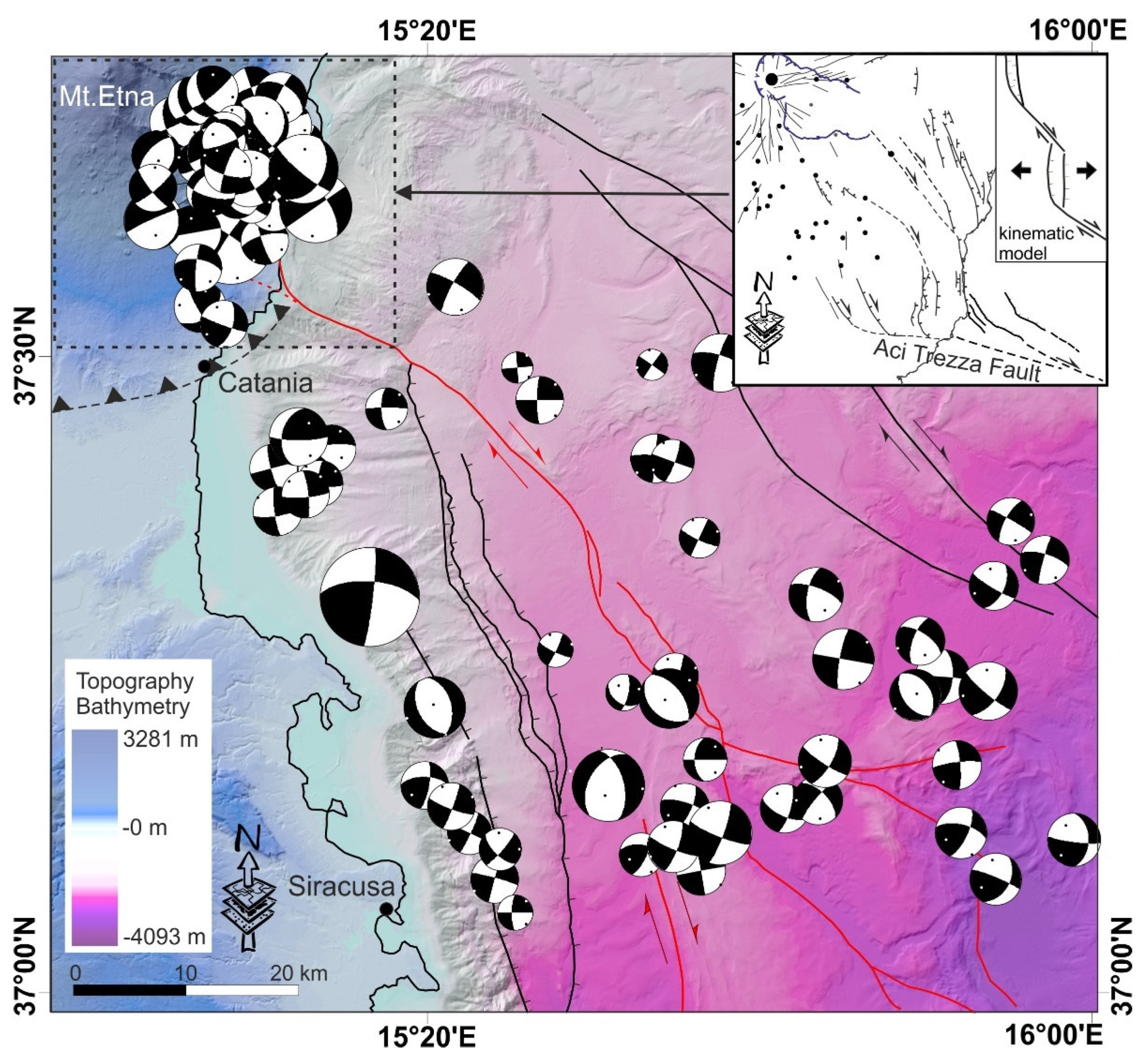
6. Seismological Data
7. Data Analysis
8. Discussion and Conclusions
Author Contributions
Funding
Institutional Review Board Statement
Informed Consent Statement
Data Availability Statement
Acknowledgments
Conflicts of Interest
References
- Branca, S.; Coltelli, M.; De Beni, E.; Wijbrans, J. Geological evolution of Mount Etna volcano (Italy) from earliest products until the first central volcanism (between 500 and 100 ka ago) inferred from geochronological and stratigraphic data. Geol. Rundsch. 2007, 97, 135–152. [Google Scholar] [CrossRef]
- Barreca, G.; Branca, S.; Monaco, C. Three-Dimensional Modeling of Mount Etna Volcano: Volume Assessment, Trend of Eruption Rates, and Geodynamic Significance. Tectonics 2018, 37, 842–857. [Google Scholar] [CrossRef]
- Monaco, C.; Tapponier, P.; Tortorici, L.; Gillot, P.Y. Late Quaternary slip rates on the Acireale-Piedimonte normal faults and tectonic origin of Mt. Etna (Sicily). Earth Planet. Sc. Lett. 1997, 147, 125–139. [Google Scholar] [CrossRef]
- Giacomoni, P.P.; Ferlito, C.; Alesci, G.; Coltorti, M.; Monaco, C.; Viccaro, M.; Cristofolini, R. A common feeding system of the NE and S rifts as revealed by the bilateral 2002/2003 eruptive event at Mt. Etna (Sicily, Italy). Bull. Volcanol. 2012, 74, 2415–2433. [Google Scholar] [CrossRef]
- Bruno, V.; Ferlito, C.; Mattia, M.; Monaco, C.; Rossi, M.; Scandura, D. Evidence of a shallow magma intrusion beneath the NE Rift system of Mt. Etna during 2013. Terra Nova 2016, 28, 356–363. [Google Scholar] [CrossRef]
- Branca, S.; Coltelli, M.; Groppelli, G.; Lentini, F. Geological map of Etna volcano, 1:50,000 scale. Ital. J. Geosci. 2011, 130, 265–291. [Google Scholar] [CrossRef]
- Monaco, C.; Catalano, S.; Cocina, O.; De Guidi, G.; Ferlito, C.; Gresta, S.; Musumeci, C.; Tortorici, L. Tectonic control on the eruptive dynamics at Mt. Etna volcano (eastern Sicily during the 2001 and 2002–2003 eruptions. J. Volcanol. Geother. Res. 2005, 144, 221–233. [Google Scholar] [CrossRef]
- Gambino, S.; Barreca, G.; Gross, F.; Monaco, C.; Gutscher, M.; Alsop, G.I. Assessing the rate of crustal extension by 2D sequential restoration analysis: A case study from the active portion of the malta escarpment. Basin Res. 2022, 34, 321–341. [Google Scholar] [CrossRef]
- Polonia, A.; Torelli, L.; Artoni, A.; Carlini, M.; Faccenna, C.; Ferranti, L.; Gasperini, L.; Govers, R.; Klaeschen, D.; Monaco, C.; et al. The Ionian and Alfeo-Etna fault zones: New segments of an evolving plate boundary in the central Mediterranean Sea? Tectonophys. 2016, 675, 69–90. [Google Scholar] [CrossRef]
- Gutscher, M.-A.; Dominguez, S.; de Lepinay, B.M.; Pinheiro, L.; Gallais, F.; Babonneau, N.; Cattaneo, A.; Le Faou, Y.; Barreca, G.; Micallef, A.; et al. Tectonic expression of an active slab tear from high-resolution seismic and bathymetric data offshore Sicily (Ionian Sea). Tectonics 2016, 35, 39–54. [Google Scholar] [CrossRef] [Green Version]
- Palano, M.; Ferranti, L.; Monaco, C.; Mattia, M.; Aloisi, M.; Bruno, V.; Cannavò, F.; Siligato, G. GPS velocity and strain fields in Sicily and southern Calabria, Italy: Updated geodetic constraints on tectonic block interaction in the central Mediterranean. J. Geophys. Res. Earth Surf. 2012, 117, 07401. [Google Scholar] [CrossRef] [Green Version]
- De Guidi, G.; Lanzafame, G.; Palano, M.; Puglisi, G.; Scaltrito, A.; Scarfì, L. Multidisciplinary study of the Tindari Fault (Sicily, Italy) separating ongoing contractional and extensional compartments along the active Africa–Eurasia convergent boundary. Tectonophys. 2013, 588, 1–17. [Google Scholar] [CrossRef]
- D’Agostino, N.; Selvaggi, G. Crustal motion along the Eurasia-Nubia plate boundary in the Calabrian Arc and Sicily and active extension in the Messina Straits from GPS measurements. J. Geophys. Res. Earth Surf. 2004, 109. [Google Scholar] [CrossRef]
- Serpelloni, E.; Bürgmann, R.; Anzidei, M.; Baldi, P.; Ventura, B.M.; Boschi, E. Strain accumulation across the Messina Straits and kinematics of Sicily and Calabria from GPS data and dislocation modeling. Earth Planet. Sci. Lett. 2010, 298, 347–360. [Google Scholar] [CrossRef] [Green Version]
- Lo Giudice, E.; Rasà, R. Very shallow earthquakes and brittle deformation in active volcanic areas: The Etnean region as an example. Tectonophysics 1992, 202, 257–262. [Google Scholar] [CrossRef]
- De Guidi, G.; Brighenti, F.; Carnemolla, F.; Cataldo, D.; Piro, A.G. New rapid vertical deformation of Santa Tecla Fault scarp (Mt. Etna volcano, Sicily) by lichenometry method. Quat. Int. 2019, 525, 78–88. [Google Scholar] [CrossRef]
- Gresta, S.; Bella, D.; Musumeci, C.; Carveni, P. Some efforts on active faulting processes (earthquake and aseismic creep) acting on the eastern flank of Mt. Etna (Sicily). Acta Vulcanol. 1997, 9, 101–107. [Google Scholar]
- Monaco, C.; De Guidi, G.; Ferlito, C. The Morphotectonic map of Mt. Etna. Ital. J. Geosci. 2010, 129, 408–428. [Google Scholar] [CrossRef]
- Azzaro, R. Earthquake surface faulting at Mount Etna volcano (Sicily) and implications for active tectonics. J. Geodyn. 1999, 28, 193–213. [Google Scholar] [CrossRef]
- Azzaro, R. Seismicity and Active Tectonics in the Etna Region: Constraints for a Seismotectonic Model. In Mt. Etna: Volcano Laboratory; Geophysical Monograph Series; Bonaccorso, A., Calvari, S., Coltelli, M., Del Negro, C., Falsaperla, S., Eds.; AGU: Washington, DC, USA, 2004; Volume 143, pp. 205–220. [Google Scholar]
- Azzaro, R.; Branca, S.; Gwinner, K.; Coltelli, M. The volcano-tectonic map of Etna volcano, 1:100.000 scale: An integrated approach based on a morphotectonic analysis from high-resolution DEM constrained by geologic, active faulting and seismotectonic data. Ital. J. Geosci. 2012, 131, 153–170. [Google Scholar] [CrossRef]
- Barreca, G.; Bonforte, A.; Neri, M. A pilot GIS database of active faults of Mt. Etna (Sicily): A tool for integrated hazard evaluation. J. Volcanol. Geotherm. Res. 2013, 251, 170–186. [Google Scholar] [CrossRef]
- Hirn, A.; Nicolich, R.; Gallart, J.; Laigle, M.; Cernobori, L.; ETNASEIS Scientific Group. Roots of Etna volcano in faults of great earthquakes. Earth Planet. Sci. Lett. 1997, 148, 171–191. [Google Scholar] [CrossRef]
- Gvirtzman, Z.; Nur, A. The formation of Mount Etna as the consequence of slab rollback. Nature 1999, 401, 782–785. [Google Scholar] [CrossRef]
- Doglioni, C.; Innocenti, F.; Mariotti, G. Why Mt Etna? Terra Nova 2001, 13, 25–31. [Google Scholar] [CrossRef] [Green Version]
- Argnani, A.; Mazzarini, F.; Bonazzi, C.; Bisson, M.; Isola, I. The deformation offshore of Mount Etna as imaged by multichannel seismic reflection profiles. J. Volcanol. Geotherm. Res. 2013, 251, 50–64. [Google Scholar] [CrossRef]
- Maesano, F.E.; Tiberti, M.M.; Basili, R. Deformation and Fault Propagation at the Lateral Termination of a Subduction Zone: The Alfeo Fault System in the Calabrian Arc, Southern Italy. Front. Earth Sci. 2020, 8, 107. [Google Scholar] [CrossRef]
- Barreca, G.; Branca, S.; Corsaro, R.A.; Scarfì, L.; Cannavò, F.; Aloisi, M.; Monaco, C.; Faccenna, C. Slab Detachment, Mantle Flow, and Crustal Collision in Eastern Sicily (Southern Italy): Implications on Mount Etna Volcanism. Tectonics 2020, 39, e2020TC006188. [Google Scholar] [CrossRef]
- Sgroi, T.; Polonia, A.; Barberi, G.; Billi, A.; Gasperini, L. New seismological data from the Calabrian arc reveal arc-orthogonal extension across the subduction zone. Sci. Rep. 2021, 11, 473. [Google Scholar] [CrossRef]
- Monaco, C.; Barreca, G.; Bella, D.; Brighenti, F.; Bruno, V.; Carnemolla, F.; De Guidi, G.; Mattia, M.; Menichetti, M.; Roccheggiani, M.; et al. The seismogenic source of the 2018 December 26th earthquake (Mt. Etna, Italy): A shear zone in the unstable eastern flank of the volcano. J. Geodyn. 2021, 143, 101807. [Google Scholar] [CrossRef]
- Sgroi, T.; Lavecchia, G.; De Nardis, R. Crustal structure and seismotectonics of central Sicily (southern Italy): New constraints from instrumental seismicity. Geophys. J. Int. 2012, 189, 1237–1252. [Google Scholar] [CrossRef] [Green Version]
- De Guidi, G.; Barberi, G.; Barreca, G.; Bruno, V.; Cultrera, F.; Grassi, S.; Imposa, S.; Mattia, M.; Monaco, C.; Scarfì, L.; et al. Geological, seismological and geodetic evidence of active thrusting and folding south of Mt. Etna (eastern Sicily): Revaluation of “seismic efficiency” of the Sicilian Basal Thrust. J. Geodyn. 2015, 90, 32–41. [Google Scholar] [CrossRef]
- Scarfì, L.; Barberi, G.; Barreca, G.; Cannavò, F.; Koulakov, I.; Patanè, D. Slab narrowing in the Central Mediterranean: The Calabro-Ionian subduction zone as imaged by high resolution seismic tomography. Sci. Rep. 2018, 8, 5178. [Google Scholar] [CrossRef] [PubMed] [Green Version]
- Barreca, G.; Scarfì, L.; Gross, F.; Monaco, C.; De Guidi, G. Fault pattern and seismotectonic potential at the south-western edge of the Ionian Subduction system (southern Italy): New field and geophysical constraints. Tectonophysics 2019, 761, 31–45. [Google Scholar] [CrossRef]
- Azzaro, R.; Bonforte, A.; Branca, S.; Guglielmino, F. Geometry and kinematics of the fault systems controlling the unstable flank of Etna volcano (Sicily). J. Volcanol. Geotherm. Res. 2013, 251, 5–15. [Google Scholar] [CrossRef]
- Mattia, M.; Bruno, V.; Caltabiano, T.; Cannata, A.; Cannavò, F.; D’Alessandro, W.; Di Grazia, G.; Federico, C.; Giammanco, S.; La Spina, A.; et al. A comprehensive interpretative model of slow slip events on Mt. Etna’s eastern flank. Geochem. Geophys. Geosystems 2015, 16, 635–658. [Google Scholar] [CrossRef]
- Corsaro, R.A.; Neri, M.; Pompilio, M. Paleo-environmental and volcano-tectonic evolution of the southern flank of Mt. Etna during the last 225 ka inferred from the volcanic succession of the «Timpe», Acireale, Sicily. J. Volcanol. Geother. Res. 2002, 113, 289–306. [Google Scholar] [CrossRef]
- Azzaro, R.; D’Amico, S.; Tuvè, T. Estimating the Magnitude of Historical Earthquakes from Macroseismic Intensity Data: New Relationships for the Volcanic Region of Mount Etna (Italy). Seism. Res. Lett. 2011, 82, 533–544. [Google Scholar] [CrossRef]
- Scarfì, L.; Messina, A.; Cassisi, C. Sicily and southern Calabria focal mechanism database: A valuable tool for local and regional stress-field determination. Ann. Geophys. 2013, 56, D0109. [Google Scholar] [CrossRef]
- Scarfì, L.; Langer, H.; Messina, A.; Musumeci, C. Tectonic Regimes Inferred from Clustering of Focal Mechanisms and Their Distribution in Space: Application to the Central Mediterranean Area. J. Geophys. Res. Solid Earth 2021, 126, e2020JB020519. [Google Scholar] [CrossRef]
- Alparone, S.; Barberi, G.; Bonforte, A.; Maiolino, V.; Ursino, A. Evidence of multiple strain fields beneath the eastern flank of Mt. Etna volcano (Sicily, Italy) deduced from seismic and geodetic data during 2003–2004. Bull. Volcanol. 2011, 73, 869–885. [Google Scholar] [CrossRef]
- De Guidi, G.; Scudero, S.; Gresta, S. New insights into the local crust structure of Mt. Etna volcano from seismological and morphotectonic data. J. Volcanol. Geotherm. Res. 2012, 223–224, 83–92. [Google Scholar] [CrossRef]
- Bonaccorso, A.; Aloisi, M.; Mattia, M. Dike emplacement forerunning the Etna July 2001 eruption modeled through continuous tilt and GPS data. Geophys. Res. Lett. 2002, 29, 1–4. [Google Scholar] [CrossRef]
- Bonanno, A.; Palano, M.; Privitera, E.; Gresta, S.; Puglisi, G. Magma intrusion mechanisms and redistribution of seismogenic stress at Mt. Etna volcano (1997–1998). Terra Nova 2011, 23, 339–348. [Google Scholar] [CrossRef]
- Bonforte, A.; Guglielmino, F.; Puglisi, G. Large dyke intrusion and small eruption: The December 24, 2018 Mt. Etna eruption imaged by Sentinel-1 data. Terra Nova 2019, 31, 405–412. [Google Scholar] [CrossRef]
- De Novellis, V.; Atzori, S.; De Luca, C.; Manzo, M.; Valerio, E.; Bonano, M.; Cardaci, C.; Castaldo, R.; Di Bucci, D.; Manunta, M.; et al. DInSAR Analysis and Analytical Modeling of Mount Etna Displacements: The December 2018 Volcano-Tectonic Crisis. Geophys. Res. Lett. 2019, 46, 5817–5827. [Google Scholar] [CrossRef] [Green Version]
- Barreca, G.; Corradino, M.; Monaco, C.; Pepe, F. Active Tectonics along the South East Offshore Margin of Mt. Etna: New Insights from High-Resolution Seismic Profiles. Geosciences 2018, 8, 62. [Google Scholar] [CrossRef] [Green Version]
- Cocina, O.; Neri, G.; Privitera, E.; Spampinato, S. Stress tensor computations in the Mount Etna area (Southern Italy) and tectonic implications. J. Geodyn. 1997, 23, 109–127. [Google Scholar] [CrossRef]
- Lanzafame, G.; Neri, M.; Coltelli, M.; Lodato, L.; Rust, D. North–South compression in the Mt. Etna region (Sicily): Spatial and temporal distribution. Acta Vulcanol. 1997, 9, 121–133. [Google Scholar]
- Patanè, D.; Privitera, E. Seismicity related to 1989 and 1991–1993 Mt. Etna (Italy) eruptions: Kinematic constraints by FPS analysis. J. Volcanol. Geother. Res. 2001, 109, 77–98. [Google Scholar] [CrossRef]
- Labaume, P.; Bousquet, J.C.; Lanzafame, G. Early deformation at a submarinecompressive front: The Quaternary Catania foredeep south of Mt. Etna, Sicily, Italy. Tectonophysics 1990, 177, 349–366. [Google Scholar] [CrossRef]
- Ristuccia, G.M.; Di Stefano, A.; Gueli, A.M.; Monaco, C.; Stella, G.; Troja, S.O. OSL chronology of Quaternary terraced deposits outcropping between Mt. Etna volcano and the Catania Plain (Sicily, southern Italy). Phys. Chem. Earth Parts 2013, 63, 36–46. [Google Scholar] [CrossRef]
- Bonforte, A.; Guglielmino, F.; Coltelli, M.; Ferretti, A.; Puglisi, G. Structural assessment of Mount Etna volcano from Permanent Scatterers analysis. Geochem. Geophys. Geosyst. 2011, 12, 1–19. [Google Scholar] [CrossRef] [Green Version]
- Gross, F.; Krastel, S.; Geersen, J.; Behrmann, J.H.; Ridente, D.; Chiocci, F.L.; Bialas, J.; Papenberg, C.; Cukur, D.; Urlaub, M.; et al. The limits of seaward spreading and slope instability at the continental margin offshore Mt Etna, imaged by high-resolution 2D seismic data. Tectonophysics 2016, 667, 63–76. [Google Scholar] [CrossRef]
- Branca, S.; De Guidi, G.; Lanzafame, G.; Monaco, C. Holocene vertical deformation along the coastal sector of Mt. Etna volcano (eastern Sicily, Italy): Implications on the time–space constrains of the volcano lateral sliding. J. Geodyn. 2014, 82, 194–203. [Google Scholar] [CrossRef]
- Govers, R.; Wortel, M. Lithosphere tearing at STEP faults: Response to edges of subduction zones. Earth Planet. Sci. Lett. 2005, 236, 505–523. [Google Scholar] [CrossRef]
- Gambino, S.; Barreca, G.; Gross, F.; Monaco, C.; Krastel, S.; Gutscher, M.-A. Deformation Pattern of the Northern Sector of the Malta Escarpment (Offshore SE Sicily, Italy): Fault Dimension, Slip Prediction, and Seismotectonic Implications. Front. Earth Sci. 2021, 8, 1–20. [Google Scholar] [CrossRef]
- Musumeci, C.; Scarfì, L.; Palano, M.; Patanè, D. Foreland segmentation along an active convergent margin: New constraints in southeastern Sicily (Italy) from seismic and geodetic observations. Tectonophysics 2014, 630, 137–149. [Google Scholar] [CrossRef]
- Chiocci, F.L.; Coltelli, M.; Bosman, A.; Cavallaro, D. Continental margin large-scale instability controlling the flank sliding of Etna volcano. Earth Planet. Sci. Lett. 2011, 305, 57–64. [Google Scholar] [CrossRef]
- C.N.R. Geological Map of Mt. Etna. Scale 1:50,000; L.A.C.: Florence, Italy, 1979. [Google Scholar]
- Mattia, M.; Bruno, V.; Montgomery-Brown, E.; Patanè, D.; Barberi, G.; Coltelli, M. Combined seismic and geodetic analysis before, during and after the 2018 Mt. Etna eruption. Geochem. Geophys. Geosyst. 2020, 21, e2020GC009218. [Google Scholar] [CrossRef]
- Civico, R.; Pucci, S.; Nappi, R.; Azzaro, R.; Villani, F.; Pantosti, D.; Cinti, F.R.; Pizzimenti, L.; Branca, S.; Brunori, C.A.; et al. Surface ruptures following the 26 December 2018, Mw 4.9, Mt. Etna earthquake, Sicily (Italy). J. Maps 2019, 15, 831–837. [Google Scholar] [CrossRef] [Green Version]
- Rasà, R.; Azzaro, R.; Leonardi, O. Aseismic Creep on Faults and Flank Instability at Mt. Etna Volcano, Sicily. In Volcano Instability on the Earth and Other Planets; McGuire, W.C., Jones, A.P., Neuberg, J., Eds.; Geological Society Special Publication; The Geological Society: London, UK, 1996; Volume 110, pp. 179–192. [Google Scholar]
- Azzaro, R.; D’Amico, S.; Mostaccio, A.; Scarfì, L.; Tuvè, T. Terremoti con effetti macrosismici in Sicilia orientale nel periodo Gennaio 2002–Dicembre 2005. Quad. Geof. 2006, 41, 62. [Google Scholar]
- De Guidi, G.; Brighenti, F.; Carnemolla, F.; Imposa, S.; Marchese, S.A.; Palano, M.; Scudero, S.; Vecchio, A. The unstable eastern flank of Mt. Etna volcano (Italy): First results of a GNSS-based network at its southeastern edge. J. Volcanol. Geotherm. Res. 2018, 357, 418–424. [Google Scholar] [CrossRef]
- Carlino, M.F.; Cavallaro, D.; Coltelli, M.; Cocchi, L.; Zgur, F.; Patanè, D. Time and space scattered volcanism of Mt. Etna driven by strike-slip tectonics. Sci. Rep. 2019, 9, 12125. [Google Scholar] [CrossRef] [PubMed]
- Bruno, V.; Mattia, M.; Aloisi, M.; Palano, M.; Cannavo’, F.; Holt, W.E. Ground deformations and volcanic processes as imaged by CGPS data at Mt. Etna (Italy) between 2003 and 2008. J. Geophys. Res. Earth Surf. 2012, 117, 1–23. [Google Scholar] [CrossRef]
- Aloisi, M.; Mattia, M.; Ferlito, C.; Palano, M.; Bruno, V.; Cannavò, F. Imaging the multi-level magma reservoir at Mt. Etna volcano (Italy). Geophys. Res. Lett. 2011, 38, L16306. [Google Scholar] [CrossRef]
- Bruno, V.; Mattia, M.; Montgomery-Brown, E.; Rossi, M.; Scandura, D. Inflation Leading to a Slow Slip Event and Volcanic Unrest at Mount Etna in 2016: Insights from CGPS Data. Geophys. Res. Lett. 2017, 44, 12–141. [Google Scholar] [CrossRef]
- Herring, T.A.; Floyd, M.A.; King, R.W.; McClusky, S.C. GLOBK: Global Kalman Filter VLBI and GPS Analysis Program. In Reference Manual; Massachusetts Institute of Technology: Cambridge, UK, 2015. [Google Scholar]
- Herring, T.A.; King, R.W.; Floyd, M.A.; McClusky, S.C. GPS Analysis at MIT. In GAMIT Reference Manual; Massachusetts Institute of Technology: Cambridge, UK, 2018. [Google Scholar]
- Haines, A.J.; Holt, W.E. A procedure for obtaining the complete horizontal motions within zones of distributed deformation from the inversion of strain rate data. J. Geophys. Res. Earth Surf. 1993, 98, 12057–12082. [Google Scholar] [CrossRef]
- Holt, W.E.; Haines, A.J. The kinematics of northern South Island, New Zealand, determined from geologic strain rates. J. Geophys. Res. Earth Surf. 1995, 100, 17991–18010. [Google Scholar] [CrossRef]
- Haines, A.J.; Jackson, A.; Holt, W.E.; Agnew, D.C. Representing Distributed Deformation by Continuous Velocity Fields; Science Report 1998, 98/5; Institute of Geology and Nuclear Science: Wellington, New Zeland, 1998. [Google Scholar]
- Krastel, S. Short cruise report: MAGOMET—Offshore Flank Movement of Mount Etna and Associated Landslide Hazard in the Ionian Sea (Mediterranean Sea). In Proceedings of the RV Poseidon-Cruise POS496, Malaga, Catania, 24 March–4 April 2016; Christian-Albrechts-Universität zu Kiel, Institute of Geosciences: Kiel, Germany, 2016. 8p. [Google Scholar]
- Gutscher, M.-A.; Kopp, H.; Krastel, S.; Bohrmann, G.; Garlan, T.; Zaragosi, S.; Klaucke, I.; Wintersteller, P.; Loubrieu, B.; Le Faou, Y.; et al. Active tectonics of the Calabrian subduction revealed by new multi-beam bathymetric data and high-resolution seismic profiles in the Ionian Sea (Central Mediterranean). Earth Planet. Sci. Lett. 2017, 461, 61–72. [Google Scholar] [CrossRef] [Green Version]
- Camerlenghi, A.; Del Ben, A.; Hübscher, C.; Forlin, E.; Geletti, R.; Brancatelli, G.; Micallef, A.; Saule, M.; Facchin, L. Seismic markers of the Messinian salinity crisis in the deep Ionian Basin. Basin Res. 2020, 32, 716–738. [Google Scholar] [CrossRef] [Green Version]
- Micallef, A.; Camerlenghi, A.; Garcia-Castellanos, D.; Otero, D.C.; Gutscher, M.-A.; Barreca, G.; Spatola, D.; Facchin, L.; Geletti, R.; Krastel, S.; et al. Evidence of the Zanclean megaflood in the eastern Mediterranean Basin. Sci. Rep. 2018, 8, 1078. [Google Scholar] [CrossRef] [PubMed] [Green Version]
- Gaillot, A.; Gutscher, M.A.; Murphy, S.; Klingelhoefer, F. Micro-Bathymetric Mapping of the North Alfeo Strike-Slip Fault (Offshore Catania Sicily): Preliminary Results from the FocusX1 Expedition. In Proceedings of the EGU General Assembly 2021, Online, 19–30 April 2021. EGU21-2731. [Google Scholar] [CrossRef]
- Scandone, P.; Patacca, E.; Radoicic, R.; Ryan, W.B.F.; Cita, M.B.; Rawson, M.; Chezar, H.; Miller, E.; McKenzie, J.; Rossi, S. Mesozoic and Cenozoic rocks from Malta escarpment (Central Mediterranean). AAPG Bull. 1981, 65, 1299–1319. [Google Scholar]
- Catalano, R.; Franchino, A.; Merlini, S.; Sulli, A. A crustal section on the eastern Algerian basin to the Ionian ocean (central Mediterranea). Mem. Soc. Geol. It. 2000, 55, 71–85. [Google Scholar]
- Barreca, G. Geological and geophysical evidences for mud diapirism in south-eastern Sicily (Italy) and geodynamic implications. J. Geodyn. 2014, 82, 168–177. [Google Scholar] [CrossRef]
- Polonia, A.; Torelli, L.; Gasperini, L.; Cocchi, L.; Muccini, F.; Bonatti, E.; Hensen, C.; Schmidt, M.; Romano, S.; Artoni, A.; et al. Lower plate serpentinite diapirism in the Calabrian Arc subduction complex. Nat. Commun. 2017, 8, 1–13. [Google Scholar] [CrossRef] [PubMed] [Green Version]
- Woodcock, N.H.; Fischer, M. Strike-slip duplexes. J. Struct. Geol. 1986, 8, 725–735. [Google Scholar] [CrossRef] [Green Version]
- Amato, A.; Azzara, R.; Basili, A.; Chiarabba, C.; Cocco, M.; Di Bona, M.; Selvaggi, G. Decembr 13, 1990 Eastern Sicily earthquake. Ann. Geofis. 1995, 38, 255–266. [Google Scholar]
- Zhang, H.; Thurber, C.; Bedrosian, P. Joint inversion for Vp, Vs, and Vp/Vs at SAFOD, Parkfield, California. Geochem. Geophys. Geosystems 2009, 10, Q11002. [Google Scholar] [CrossRef]
- De Guidi, G.; Caputo, R.; Scudero, S. Regional and local stress field orientation inferred from quantitative analyses of extension joints: Case study from southern Italy. Tectonics 2013, 32, 239–251. [Google Scholar] [CrossRef] [Green Version]
- Fossen, H. Structural Geology, 2nd ed.; Cambridge University Press: Cambridge, UK, 2016; 524p, ISBN 9781107057647. [Google Scholar]
- Woodcock, N.H.; Schubert, C. Continental Strike-Slip Tectonics. In Continental Deformation; Hancock, P.L., Ed.; Pergamon Press: New York, NY, USA, 1994; pp. 251–263. [Google Scholar]
- Sylvester, A.G. Strike-slip faults. Geol. Soc. of Am. Bull. 1988, 100, 1666–1703. [Google Scholar] [CrossRef]
- Spampinato, C.R.; Scicchitano, G.; Ferranti, L.; Monaco, C. Raised Holocene paleo-shorelines along the Capo Schisò coast, Taormina: New evidence of recent co-seismic deformation in northeastern Sicily (Italy). J. Geodyn. 2012, 55, 18–31. [Google Scholar] [CrossRef]
- Murru, M.; Montuori, C.; Wyss, M.; Privitera, E. The locations of magma chambers at Mt. Etna, Italy, mapped byb-values. Geophys. Res. Lett. 1999, 26, 2553–2556. [Google Scholar] [CrossRef]
- Patanè, D.; Chiarabba, C.; De Gori, P.; Bonaccorso, A. Magma ascent and the pressurization of Mt. Etna’s volcanic system. Science 2003, 299, 2061–2063. [Google Scholar] [CrossRef] [PubMed]
- Patanè, D.; Mattia, M.; Aloisi, M. Shallow intrusive processes during 2002–2004 and current volcanic activity on Mt. Etna. Geophys. Res. Lett. 2005, 32, L06302. [Google Scholar] [CrossRef]
- Patanè, D.; Barberi, G.; Cocina, O.; De Gori, P.; Chiarabba, C. Time-Resolved Seismic Tomography Detects Magma Intrusions at Mount Etna. Science 2006, 313, 821–823. [Google Scholar] [CrossRef] [Green Version]
- De Gori, P.; Chiarabba, C.; Patanè, D. Qpstructure of Mount Etna: Constraints for the physics of the plumbing system. J. Geophys. Res. Earth Surf. 2005, 110, B05303. [Google Scholar] [CrossRef]
- Mazzarini, F.; Armienti, P. Flank Cones at Mount Etna Volcano: Do they have a power-law distribution? Bull. Volcanol. 2001, 62, 420–430. [Google Scholar] [CrossRef]
- Favalli, M.; Karátson, D.; Mazzarini, F.; Pareschi, M.T.; Boschi, E. Morphometry of scoria cones located on a volcano flank: A case study from Mt. Etna (Italy), based on high-resolution LiDAR data. J. Volcanol. Geotherm. Res. 2009, 186, 320–330. [Google Scholar] [CrossRef]
- Ferlito, C. Mount Etna volcano (Italy). Just a giant hot spring! Earth-Sci. Rev. 2018, 177, 14–23. [Google Scholar] [CrossRef]
- Ferlito, C.; Viccaro, M.; Cristofolini, R. Volatile-rich magma injection into the feeding system during the 2001 eruption of Mt. Etna (Italy): Its role on explosive activity and change in rheology of lavas. Bull. Volcanol. 2009, 71, 1149–1158. [Google Scholar] [CrossRef]
- Ferlito, C.; Coltorti, M.; Lanzafame, G.; Giacomoni, P.P. The volatile flushing triggers eruptions at open conduit volcanoes: Evidence from Mount Etna volcano (Italy). Lithos 2014, 184–187, 447–455. [Google Scholar] [CrossRef]
- Uslular, G.; Le Corvec, N.; Mazzarini, F.; Legrand, D.; Gençalioğlu-Kuşcu, G. Morphological and multivariate statistical analysis of quaternary monogenetic vents in the Central Anatolian Volcanic Province (Turkey): Implications for the volcano-tectonic evolution. J. Volcanol. Geotherm. Res. 2021, 416, 107280. [Google Scholar] [CrossRef]
- Mazzuoli, R.; Tortorici, L.; Ventura, G. Oblique rifting in Salina, Lipari and Vulcano islands (Aeolian islands, southern Italy). Terra Nova 1995, 7, 444–452. [Google Scholar] [CrossRef]
- Vries, B.V.W.D.; Merle, O. Extension induced by volcanic loading in regional strike-slip zones. Geology 1998, 26, 983–986. [Google Scholar] [CrossRef]
- Alaniz-Álvarez, S.; Nieto-Samaniego, A.; Morán-Zenteno, D.; Aldave, L.A.A. Rhyolitic volcanism in extension zone associated with strike-slip tectonics in the Taxco region, southern Mexico. J. Volcanol. Geotherm. Res. 2002, 118, 1–14. [Google Scholar] [CrossRef]
- Di Giuseppe, P.; Agostini, S.; Lustrino, M.; Karaoğlu, Ö.; Savaşçın, M.Y.; Manetti, P.; Ersoy, Y. Transition from Compression to Strike-slip Tectonics Revealed by Miocene–Pleistocene Volcanism West of the Karlıova Triple Junction (East Anatolia). J. Pet. 2017, 58, 2055–2087. [Google Scholar] [CrossRef] [Green Version]


| Seismic Unit | Period | Age (Ma) | Lithology |
|---|---|---|---|
| PQ2 | Quaternary | 2.58–0.012 | Silty sandstones |
| PQ1 | Upper Pliocene | 3.6–2.58 | Silty sandstones |
| MES | Messinian | 7.2–5.3 | Evaporites |
| Pre-MES | Pre-Messinian | up to 7.2 | Limestones |
Publisher’s Note: MDPI stays neutral with regard to jurisdictional claims in published maps and institutional affiliations. |
© 2022 by the authors. Licensee MDPI, Basel, Switzerland. This article is an open access article distributed under the terms and conditions of the Creative Commons Attribution (CC BY) license (https://creativecommons.org/licenses/by/4.0/).
Share and Cite
Gambino, S.; Barreca, G.; Bruno, V.; De Guidi, G.; Ferlito, C.; Gross, F.; Mattia, M.; Scarfì, L.; Monaco, C. Transtension at the Northern Termination of the Alfeo-Etna Fault System (Western Ionian Sea, Italy): Seismotectonic Implications and Relation with Mt. Etna Volcanism. Geosciences 2022, 12, 128. https://0-doi-org.brum.beds.ac.uk/10.3390/geosciences12030128
Gambino S, Barreca G, Bruno V, De Guidi G, Ferlito C, Gross F, Mattia M, Scarfì L, Monaco C. Transtension at the Northern Termination of the Alfeo-Etna Fault System (Western Ionian Sea, Italy): Seismotectonic Implications and Relation with Mt. Etna Volcanism. Geosciences. 2022; 12(3):128. https://0-doi-org.brum.beds.ac.uk/10.3390/geosciences12030128
Chicago/Turabian StyleGambino, Salvatore, Giovanni Barreca, Valentina Bruno, Giorgio De Guidi, Carmelo Ferlito, Felix Gross, Mario Mattia, Luciano Scarfì, and Carmelo Monaco. 2022. "Transtension at the Northern Termination of the Alfeo-Etna Fault System (Western Ionian Sea, Italy): Seismotectonic Implications and Relation with Mt. Etna Volcanism" Geosciences 12, no. 3: 128. https://0-doi-org.brum.beds.ac.uk/10.3390/geosciences12030128