
Complexity and Geoheritage Importance of Granite Pseudokarst from the Belaya River Gorge (Western Caucasus)


1
K.G. Razumovsky Moscow State University of Technologies and Management, The First Cossack University, Zemlyanoy Val Street 73, 109004 Moscow, Russia
2
Department of Organization and Technologies of Service Activities, Higher School of Business, Southern Federal University, 23-ja Linija Street 43, 344019 Rostov-on-Don, Russia
Geosciences 2022, 12(4), 175; https://0-doi-org.brum.beds.ac.uk/10.3390/geosciences12040175
Submission received: 14 March 2022
/
Revised: 6 April 2022
/
Accepted: 14 April 2022
/
Published: 15 April 2022
Abstract
:New investigations in the Western Caucasus contribute to the understanding of granite pseudokarst (sensu lato) and megaclasts linked to river erosion. A plot on the bank of the Belaya River (Mountainous Adygeya, Western Caucasus) was selected to examine diverse and abundant pseudokarst features (small rock basins, hollows, potholes, and channels) and large clasts. Morphological analysis of these features clarifies their general characteristics and genetic interpretations. Pseudokarst features can be classified into two major categories, namely the relatively small (<1 m) and large (>1 m) features. Potholes, which are usually 1–3 m in size, are the most characteristic features occurring on two levels, i.e., on steep walls of the gorge (half-filled with river water) and on slightly inclined surfaces of a terrace-like landform (subaerial exposure). In both cases, their walls from the side of the river are broken. Apparently, these potholes were formed on the river bottom. Subsequent incision of the gorge elevated potholes and the river has eroded them from one side. Apparently, some pseudokarst features are related to macroturbulent flood flows and granite weathering. Due to its scientific uniqueness and aesthetic attractiveness, this granite pseudokarst constitutes geoheritage, which can be exploited for the purposes of geoscience research and geotourism development.
1. Introduction
Pseudokarst is a relatively widespread geological phenomenon. However, its investigations are significantly less intense than of true karst. Moreover, the conceptual understanding of pseudokarst and the related terminology remain debatable [1,2,3,4,5,6,7,8]. Undoubtedly, advance in the understanding of pseudokarst needs representative factual basis, and, thus, it depends strongly on reporting pseudokarstic features from many regions of the world with different geological and geomrophological settings.
Granite domains are of special importance to the pseudokarst studies because granites are prone to processes producing karst-like features [9,10,11,12]. Granite pseudokarst (sensu lato) has been reported, particularly, from Antarctica [13], Argentina [14], India [15], Malaysia [16], and Spain [17,18,19]. However, many of these studies focused on weathering processes, whereas some other geological processes can also be responsible for granite “karstification”. These include river erosion that leads to formation of potholes (sometimes gigantic in size). Not as many studies have been devoted to the latter, with emphasis on the Spanish localities [20,21,22,23,24]. Field investigations in southwestern Russia have permitted to obtain a new line of evidence of granite potholes evolving under interaction of several geological phenomena in a big and nationally-known gorge [25,26,27] of the Belaya River. Although the presence of “giant cups” and “erosional bathes” on granotoid surfaces linked to the river erosion were already noted very briefly by Mikhailenko et al. [26], these features were neither documented, nor reported systematically from this region.
An objective of the present study is to characterize granite pseudokarst from the Western Caucasus, with special attention to potholes and some other co-occurring features. On the one hand, this study provides novel evidence from the region poorly known to the international research community. On the other hand, it serves to reveal the complexity of granite pseudokarst development and to stress its geoheritage importance. In this work, the term “pseudokarst” is used sensu lato, i.e., as a general term for karst-like features, which cannot be attributed to the “classical”, true karst formed by dissolution of carbonate and salt rocks (see also [28]). Besides pseudokarst, attention is also paid to large clasts occurring widely in the study area and also linked to granite erosion.
2. Geological Setting
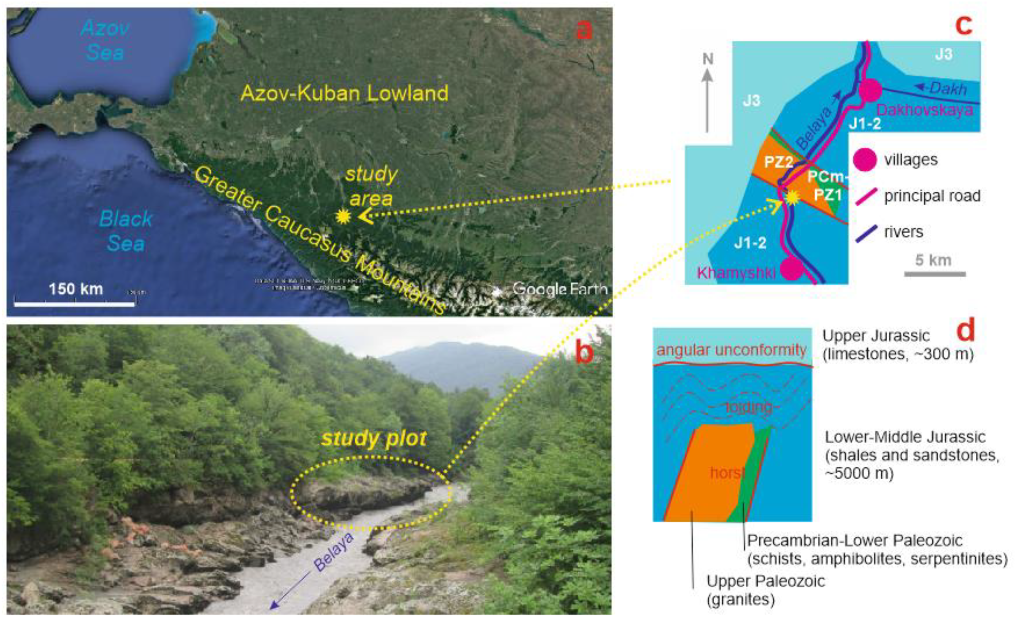
The Greater Caucasus is an elongated late Cenozoic orogen between the Black and Caspian seas [29,30,31]. Its western segment is distinguished geographically and geologically, and it is known as the Western Caucasus [32,33,34]. The study area corresponds to Mountainous Adygeya, which lies on the northern periphery of the Western Caucasus (Figure 1). It is dominated by mountain ranges with heights up to 2000 m (usually <1300 m), which are crossed (almost perpendicularly) by the Belaya River. The latter creates narrow gorges and canyons where it crosses mountain ranges, but it has a well-developed, terraced valley where it crosses the lower depressions between these ranges. In many parts, the area is covered by dense deciduous and mixed forests.
The local geology is dominated by Jurassic deposits [35]. The thick, intensively folded and faulted Sinemurian–Bathonian siliciclastics with rare carbonate layers are overlain unconformably by the thinner Callovian–Tithonian carbonates with the variegated siltstones and evaporites in the upper part (Figure 1). The Dakh crystalline massif, which is a kind of horst structure, is exposed in the center of the study area. Precambrian and Early Paleozoic metamorphic rocks are known on its flanks, but the main part of this massif consists of Late Paleozoic granitoids (Figure 1). The main rock types are light-grey granodiorites (plagioclase—40%; quartz—30%; biotite—15%; microcline—5%; hornblende—5%; and secondary chlorite—5%) and pink granites (plagioclase—30–35%; microcline 15–30%; quartz—25–30%; muscovite—3%; and biotite—2%); the former dominate the northeastern half of the massif, and the latter dominate the southwestern half of the massif [36]. The Dakh crystalline massif is expressed topographically as the Burelom Range, and the Belaya River cuts it to form a lengthy (~5 km), narrow (from several dozens to several hundreds of meters), and deep (up to 500 m) gorge. The latter is named as the Granite Gorge, and it is one of the most spectacular gorges of Russia bearing geoheritage of outstanding value [25,26,27]. In other words, this gorge is formed chiefly in the granitoids of the Dakh crystalline massif (Figure 1).
Very diverse true karst features (both caves and various karren) have been reported from the Lagonaki Highland [37,38,39], which lies in the southwestern part of the study area. In contrast, pseudokarst from Mountainous Adygeya has not attracted as much attention from geoscientists as it really deserves. Only Mikhailenko et al. [26] noted some cavities in granitoids made in the course of the Belaya River erosion. Taking into account the uplift of the Western Caucasus [40,41,42] and the destructive power of mountainous rivers [43], the presence of such erosional features is somewhat expected.
Granite pseudokarst is represented in several places of the Granite Gorge along the banks of the Belaya river. However, these features remain almost inaccessible due to steep slopes. The only well-accessible locality, which also boasts abundance and diversity of pseudokarst features, is found near the southern entrance to the gorge where the river cuts pink granites. There, the study plot with the size of ~300 m2 is chosen on the right bank of the river where a granite surface slightly inclined (~15°) to the south caps a kind of terrace, and this terrace-like landform is elevated by 1–2 m above the river (Figure 1). This surface is uncovered by any vegetation, although the latter is dense a few meters higher and develops there on a similar granitic surface.
3. Methodological Remarks
The present study aims at pioneering reporting of granite pseudokarst from the study area, which determines its methodological simplicity. Essentially, it is based on field observations, measurements, and interpretations undertaken on the representative plot. However, these preliminary investigations have provided important information for both morphological and genetic characteristics. Particularly, attention has been paid to the diversity of shapes, the size, and some qualitative peculiarities (see below) of dozens of pseudokarst features found on the study plot.
The study plot, as well as its vicinities has been examined carefully to reveal the diversity of granite pseudokarst features. These are attributed to pseudokarst tentatively in this case as a generic name of all karst-like features developed in granites. The classification of these features is yet to be developed. The researchers recognize pans, rock basins, hollows, runnels, potholes, etc., as well as use various local names as terms. The related examples and discussions can be found in the seminal works by Campbell [9], Twidale and Vidal Romaní [12], and Migoń [10,11]. For the purposes of the present study, a simplified terminology is employed to avoid misinterpretations. Relatively small pseudokarst features with sizes (diameter) < 1 m (usually 30–50 cm) are distinguished from relatively large pseudokarst features with sizes (diameter) > 1 m (usually 1–3 m). The former include small rock basins, hollows, and channels, and the latter are represented by only potholes. Indeed, some small rock basins may be underdeveloped potholes. It should be noted that pseudokarst is a general, chiefly morphological term, whereas pothole has genetic meaning (river erosion). Tentatively, the latter are assigned to the former (regardless, both are not necessarily linked to granite domains—see also below). The features were identified and characterized in regard to their size, morphology, abundance, possible destruction, and position relative to the river. The presence of water and sediment was also documented.
In addition to the noted features, important elements of the local granite pseudokarst landscape are large (>0.5 m in size) clasts of granite. Studies of large clasts constitute an important direction in contemporary geoscience research [44,45,46,47,48], and attention was also paid to them in this study. The classification of large clasts proposed by Bruno and Ruban [49], who established the boundary between boulders and megaclasts at 1 m, and the basic principles of their studies in mountainous domains [50] were employed. Size, shape, and spatial occurrence of large clasts was addressed.
4. Results
4.1. Pseudokarst Features
Pseudokarst features cover up to 70% of the gradually inclined surface of the study plot, and some of them overlap. The relatively small features are more abundant than the relatively large features, with the approximate share of 80:20. Importantly, pseudokarst features are found not only on the plot’s surface, but also on the steep walls marking the incision of the river. In other words, they occur on several levels. The lowest level corresponds to the bottom of the Belaya river, where pseudokarst is hypothesized, but totally invisible. The middle level corresponds to the noted steep walls of the terrace-like landforms. The upper level corresponds to the inclined surfaces of these landforms.
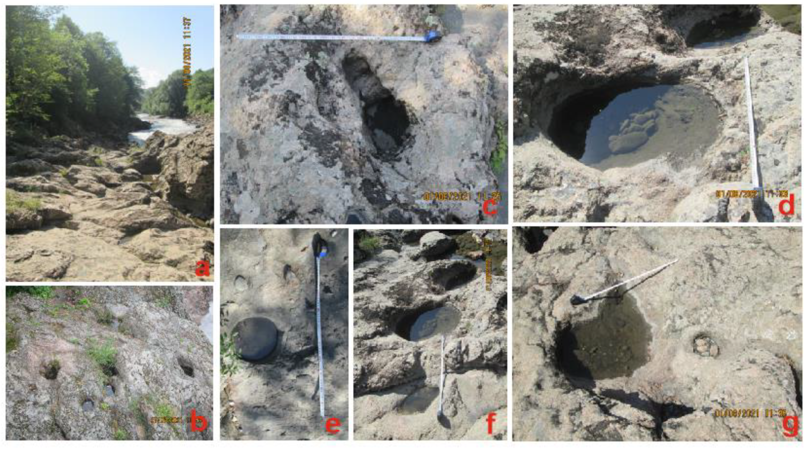
The relatively small features are rather diverse (Figure 2), and they are documented on the only upper level of the plot. Their size (diameter) varies from 5–10 cm to 1 m, but it ranges most commonly between 30–40 and 60–70 cm.
Morphologically, these are small rock basins (these can often be assigned to pits and pans), cylindrical hollows, and channels. Small rock basins have generally rather regular, round shapes, with either steep walls and flat bottom or funnel-like forms. Regardless, their depth is chiefly less than 20 cm. Irregular morphologies are also registered. These features are abundant and occur either individually or in groups. Connection by channels and overlapping also exists. Less than a third of them demonstrate certain destruction, often as a kind of smoothening. Small rock basins are found everywhere, but these tend to concentrate on rather flat surfaces in the middle part of the study plot. The majority of these features bear rainwater. River sand and a few larger clasts (all grades of gravels) are found in some of them.
Cylindrical hollows have regular shapes. They are often filled with rainwater, but they are not too deep—their depth is comparable to their diameter, and the features are attributed to this category very provisionally. These features are rare, and a group of them is found in the vicinity of the study plot, near the edge of the terrace-like landform. Finally, two kinds of channels are found. Some of them are rather short and irregular runnels connecting small rock basins. Their abundance is low-to-moderate. The others are rather long (up to 1 m), very shallow (<10 cm), and smoothened structures on the inclined surface. Their abundance is moderate, and, apparently, they form a local drainage network allowing rainwater discharge to the river. They are not filled with water or sediment.
The relatively large features are less diverse, but more complex (Figure 3). They are represented by potholes. The latter exist on the middle and upper levels of the plot. Their size (diameter) ranges from 1 to 3 m. Their shape is often irregular, although well-rounded elements are almost always present. Their depth reaches 1–1.5 m, and the bottom is either flat or fissure-like. The abundance of these features is moderate-to-high, and they tend to occur in groups being connected sometimes by short channels. A kind of overlapping is also registered. Many potholes demonstrate signs of destruction, and the most characteristic phenomenon is the destruction of one wall facing the river (in other words, potholes are often cirque-like, semi-enclosed features). Potholes often complicate steep walls of the terrace-like landform. On the upper level, they tend to concentrate near the edge of this landform, i.e., right above the river, but they are also found in the other places of the plot. Potholes of the middle level are half-filled by the water of the Belaya river, and those of the upper level are often dry, although bear some rainwater and sediment (sand and gravel particles) in some cases.
4.2. Large Clasts
Large clasts are quite common on the study plot and occupy up to 10% of the latter. Their size (diameter) differs from 0.5 to 2 m, which means these are coarse boulders (0.5–1.0 m) and fine blocks (1.0–2.5 m), according to the classification of Bruno and Ruban [49]. Coarse boulders are twice more abundant than fine blocks. However, the majority of the clasts are 0.7–1.3 m in size, which makes their accumulations look rather homogeneous. The shape of the large clasts is chiefly irregular, although many of them have brick-like views (Figure 4). The clasts are angular, although their edges are slightly smoothened. Most probably, the shapes reflect facture networks in granites.
Although a few individual large clasts are registered, the majority of them constitute several accumulations, which include dozens of particles (Figure 4). These accumulations tend to occur at the very edge of the terrace-like landform where they co-occur with ledges and larger salients of granites. The latter reach 5 m and even more and look like the largest clasts, although, in fact, they retain connection to the parent rocks. What is really notable is a high degree of sorting of the accumulations of large clasts. These are dominated (up to 90%) by coarse boulders and fine blocks, and they do not include much smaller boulders or cobbles. Indeed, smaller particles are found, but their content is limited to 10% of the accumulation volume. Interestingly, some of these particles are well-rounded pebbles, which are not related to granites, but transported by the Belaya River from the other places. In regard to the above, the accumulations of large clasts on the study plot can be referred as local megaclast–boulder deposits.
5. Discussion
5.1. Genetic Inferences
The origin of the studied granite pseudokarst is not evident. On the one hand, it can be related to the river erosion. On the other hand, it occurs mostly on the landform above the river, i.e., weathering may matter. In order to make definite judgments, attention should be paid to potholes, which are the most distinctive features. They are visible on two levels (including the middle level where they are half-filled with the river water), tend to occur near the stream, and often have one wall broken (these are always walls from the side of the river—Figure 3a). These characteristics imply that the potholes are formed on the river bottom (for descriptions of the possible mechanisms see Ji et al. [20], Lorenc et al. [21], and Ortega et al. [24]) even if they are now visible above the water level. Their subsequent development can be hypothesized as follows. When the river incises due its erosion power in the conditions of tectonic uplift, the potholes that originated at the bottom are moved upwards, and the river cuts them and makes semi-enclosed. Simultaneous filling with the river water makes potholes prone to erosion by turbulent (main river) and vortex (water inside pothole) currents, the power of which is especially strong when pebble-size particles are moved. As a result, wall breakage increases, and potholes may still grow. Further uplift leads to their elevation above the river. Therefore, three generations of potholes can be recognized, namely early potholes (actively grown on the river bottom, invisible), mature potholes (degrading near water level, partly visible), and old potholes (degrading above water level, fully visible).
The scenario provided above explains the origin of the relatively large potholes with one broken wall. It cannot be applied to the relatively small features of the upper level, i.e., occurring on the surface of the study plot. One should note that these features occur above the river and remain exposed to rainwater for a long time. If so, one can hypothesize the action of the weathering-related processes, which are well known (although remain debatable in somewhat) from the granite domains in subaerial environments [10,12]. However, many rock basins bear river sediments and well-rounded gravels (Figure 2d). Apparently, their accumulation results from major floods, which occur seasonally (chiefly in May–June, but not only), and catastrophic floods, which tend to occur several times per century (one of the most catastrophic floods occurred in the study area in summer 2002). Most probably, the absence of vegetation on the study plot is linked to seasonal floods, during which the surface is fully drowned (vegetation appears on slopes at generally the same level above the river marking the highest water level during floods). The previous studies [23] demonstrated that macroturbulent flood flows can be responsible for formation of pseudokarst features, which resemble those reported herein from the Western Caucasus. Indeed, gravels “stored” into the surface irregularities are rotated intensively and “drill” rock basins. These processes are generally identical to pothole formation on the river bottom. The size of small rock basins and hollows implies that the power/frequency of floods has not been enough to create full-scale potholes similar to those formed on the river bottom. An important question is whether all relatively small pseudokarst features should be linked to the influence of floods or some of them can be related to weathering processes on the uncovered surface of granite. Answering this question would require additional investigations of granite exposures, which are not influenced by floods. Examination of the study plot indicates the presence of small rock basins, the morphology of which would be difficult to explain by macroturbulent flood flows. These are either well-rounded and too shallow pans or fissure-like cavities, as well as irregular channels connecting rock basins or marking rainwater outflow. One should also note that the study area receives substantial annual rainfall (~1000 m), and strong rainfall is quite common there [37]. If so, it would be difficult to rule out weathering as a factor of pseudokarst development.
Apparently, floods and weathering can “erase” potholes uplifted from the bottom and already damaged, as well as they may “utilize” these potholes for creation of new rock basins. Similarly, the weathering-related features can be either destroyed or re-generated by new pulses of weathering or floods. The co-existence of various features on a small plot and evidence of their overlap proves the expected, above-noted complexity of the studied pseudokarst. The interaction of several geological phenomena, namely tectonic uplift, river erosion, floods, and weathering in the river gorge is responsible for peculiar sculpturing of hard rocks. An important question is whether such phenomena are restricted to only granite domains. In fact, very similar features are found in the other parts of the Belaya River valley, where very hard Lower Triassic and Upper Jurassic limestones are exposed. The most characteristic features are the same potholes with one broken wall (see discussions below).
The origin of the megaclast–boulder deposit from the study plot is difficult to explain. On the one hand, it is evident that large clasts could not be brought by the Belaya River from the other places. They consist of the same granite as the parent rocks exposed on the study plot, and the latter is restricted to the Granite Gorge. On the other hand, large clasts tend to occur closely to the river (not along the toe of the slope) (Figure 4), and their accumulations do not cover the entire plot. This situation challenges their relation to gravitational processes on slopes. It cannot be excluded that these large clasts originated directly on the plot due to destruction of ledges and salients of granites under the influence of temperature changes and rainwater (as occurs on inselbergs in other places—see [9,10,11,12]). Alternatively, some irregularities of the generally flat surface served as barriers and protected large clasts of colluvial origin from washing out during catastrophic floods.
5.2. Geoheritage and Geotourism Inferences
Granite domains often bear geoheritage of high value and are useful to geotourism [11,22,26,51,52,53,54]. The study plot is a part of the lengthy, linear geoheritage site (geosite), namely the Granite Gorge [25,26,27]. However, this plot is the only place in this gorge where pseudokarst features are both diverse and well-accessible. The established interaction of geological phenomena responsible for rock sculpturing is really unique and the pseudokarst features are as peculiar as those reported earlier from Spain [21,23,24]. Potholes with one broken wall seem to be especially notable, and their occurrence on two levels provides a clear illustration of how a mountainous river modifies the forms created on its bottom together with incision. The granite pseudokarst adds value and extends the diversity of the entire geosite. Particularly, the reported pseudokarst features can be assigned to the geomorphological, igneous, and hydro(geo)logical types of geoheritage, and the large clasts can be attributed to the sedimentary geoheritage type (see nomenclature of the types in [55]). Importantly, the study plot demonstrates both co-occurrence and genetic relationships between these types, which itself is important and unique. The present findings prove the importance of the gorge for the international scientific examination of granite pseudokarst related to river erosion, as well as its general complexity.
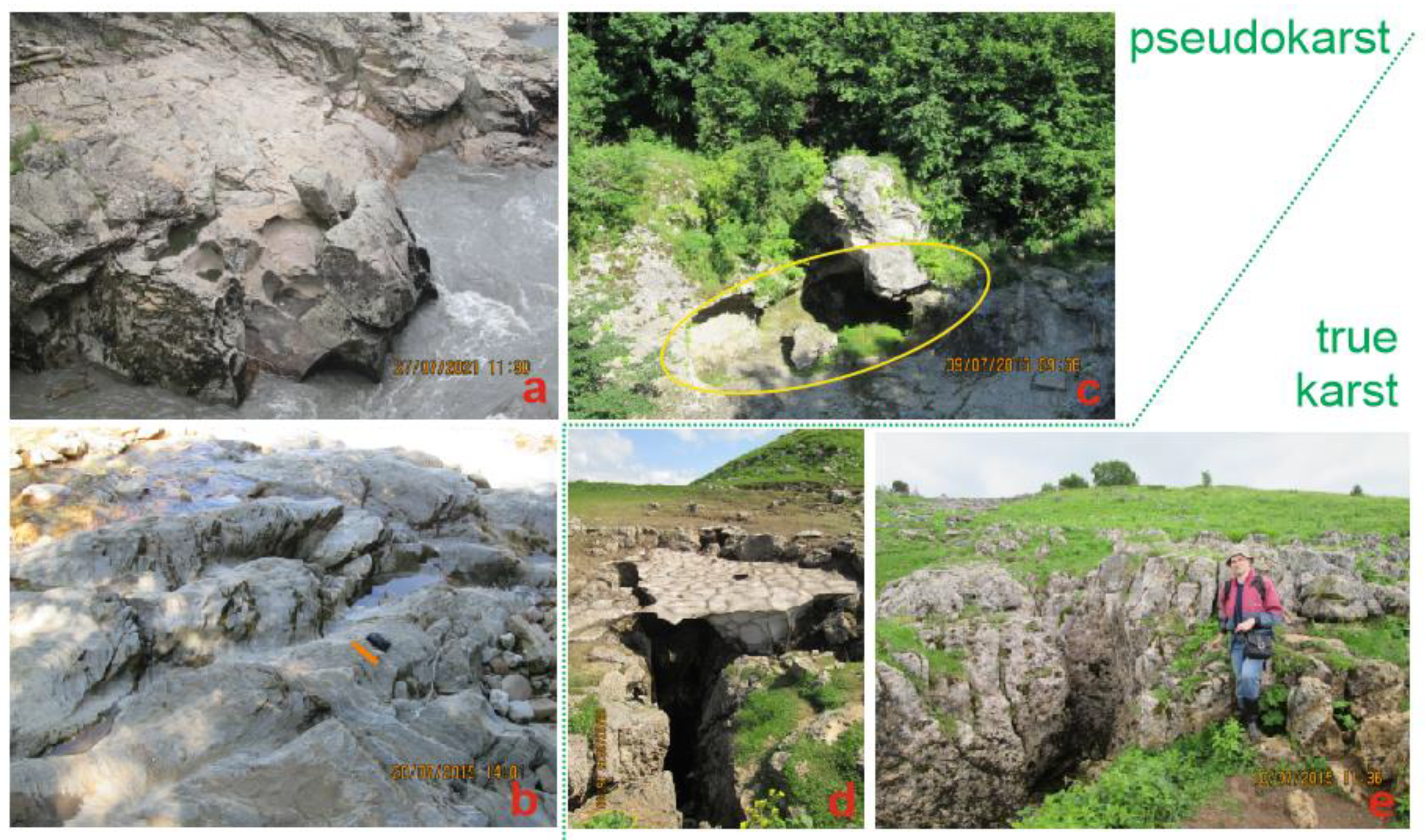
The potential geotourist importance of the analyzed granite pseudokarst is very large. On the one hand, the study plot offers a unique possibility to examine granite geology and geomorphology by relatively large groups of visitors during the course of educational excursions. On the other hand, potholes and large clasts determine high aesthetic properties of landscapes looking like natural, gigantic sculptures, ruins, and thrones. These forms appeal to some basic determinants of the tourists’ judgments of beauty [56], and they can serve ideally as photograph locations. One should also note color diversity of the local landscape, i.e., co-existence of pink granites, blue river, and green (in summer) forest. Moreover, the study area boasts some other localities of pseudokarst and true karst (Figure 5). These can be connected logically by an excursion route, which seems to be very suitable for professional geoscientists, students in geosciences, and nature amateurs (including eco- and geotourists). Particularly, the Lagonaki Highland is a Russian classical area for karst studies [37,38,39], and its close location to the study plot facilitates explanation of the karst–pseudokarst relations and differences. The entire study area seems to be ideal for investigations related to pseudokarst conceptualization and terminology, which is yet to be fixed [1,2,3,4,5,6,7]. These investigations can be arranged in the form of academic geotourism.
Indeed, the geoheritage value and the geotouristic importance of the study plot require efficient geoheritage management. Particularly, the most representative features need to be protected from natural weathering or occasional damage by visitors. Some technical solutions can be offered such as installation of protective walls or transparent plastic covers. It seems to be reasonable to establish fences along the edge of the plot (also for safety reasons) and to install metallic stairs above the plot to facilitate seeing the features from above, without direct contact with the rocks. Local administrations and private organizations interested in tourism and eco-education development in Mountainous Adygeya would support and fund such initiatives.
6. Conclusions
The undertaken investigation of the pseudokarst features in the gorge of the Belaya river permits making five general conclusions:
- (1)
- The studied pseudokarst is dominated by small rock basins, chiefly regular, rounded in shape, and larger potholes, which often have one wall broken;
- (2)
- Potholes originate on the river’s bottom, and they are “erased” from one side by the river due to its incision into the elevated geological block;
- (3)
- Pseudokarst development is linked to interaction of four geological phenomena, namely tectonic uplift, river erosion, floods (seasonal and catastrophic), and granite weathering;
- (4)
- Granite pseudokarst co-occurs with boulder–megaclast deposits, although their genetic relations are unclear;
- (5)
- The studied pseudokarst is unique and, thus, adds value and diversity to the Granite Gorge geosite, and the aesthetic attractiveness of sculptured granites is a premise for local geotourism development.
Further investigations in the study area can be linked to studying granite landforms and the related geological processes in the other parts of the Dakh crystalline massif, outside of the river gorge. Although this territory is difficult to access due to dense vegetation cover, steep slopes, and absence of trails, subaerially exposed surfaces of granitoids exist (they are visible from large distances). Finding pseudokarst there would shed light on the diversity of geological processes responsible for its origin in the study area. At least, this information will be crucial for making a clear distinction between features related to floods and weathering.
The present study is a pioneering one, and, thus, not all factors and conditions of pseudokarst development can be considered (also due to the lack of some previous research). These include granite mineralogy that can influence vulnerability of the rocks to river erosion and weathering and exact hydrological parameters of the Belaya River that determine its erosive ability. Special investigations on the study plot and in the entire gorge are necessary to deal with these issues and to make the related interpretations. Another ambitious and challenging, but very urgent, task is mapping pseudokarst features and large clast accumulations in the entire gorge. Indeed, this will require development of special techniques, as well as involvement of physically trained specialists with climbing skills due to very limited accessibility of many parts of the gorge. However, if realized, such mapping would advance the general understanding of granite pseudokarst.
Funding
This research received no external funding.
Data Availability Statement
Not applicable.
Acknowledgments
The author gratefully thanks the journal’s editors for general support, the three anonymous reviewers for helpful suggestions, P. Migoń (Poland) for provision with some essential literature, G.I. Doludenko (Russia) for driving support, and N.V. Ruban (Russia) for field assistance.
Conflicts of Interest
The author declares no conflict of interest.
References
- Grimes, K.G. Redefining the boundary between karst and pseudokarst: A discussion. Cave Karst Sci. 1997, 24, 87–90. [Google Scholar]
- Eberhard, R.; Sharples, C. Appropriate terminology for karst-like phenomena: The problem with pseudokarst. Int. J. Speleol. 2013, 42, 109–113. [Google Scholar] [CrossRef] [Green Version]
- Lavrusevich, A. Classification of the types and forms of loess pseudokarst. E3S Web Conf. 2019, 135, 01041. [Google Scholar] [CrossRef]
- Otvos, E.G. Pseudokarst and pseudokarst terrains: Problems of terminology. Bull. Geol. Soc. Am. 1976, 87, 1021–1027. [Google Scholar] [CrossRef]
- Parker, G.G.; Higgins, C.G.; Wood, W.W. Piping and pseudokarst in drylands. Spec. Pap. Geol. Soc. Am. 1990, 252, 77–110. [Google Scholar]
- Self, C.A.; Mullan, G.J. Redefining the boundary between karst and pseudokarst. Cave Karst Sci. 1996, 23, 63–70. [Google Scholar]
- Striebel, T. Problems with the terms karst and pseudokarst. Attempts at a genetic classification of sandstone and granite caves in the Bayreuth area (Germany). Mitt. Des Verb. Der Dtsch. Hohlen-Und Karstforscher 2000, 46, 99–105. [Google Scholar]
- Wray, R.A.L. Quartzite dissolution: Karst or pseudokarst? Cave Karst Sci. 1997, 24, 81–86. [Google Scholar]
- Campbell, E.M. Granite landforms. J. R. Soc. West. Aust. 1997, 80, 101–112. [Google Scholar]
- Migoń, P. Granite Landscapes of the World; Oxford University Press: Oxford, UK, 2006; 384p. [Google Scholar]
- Migoń, P. Granite Landscapes, Geodiversity and Geoheritage—Global Context. Heritage 2021, 4, 198–219. [Google Scholar] [CrossRef]
- Twidale, R.; Vidal Romaní, J.R. Landforms and Geology of Granite Terrains; CRC Press: London, UK, 2005; 354p. [Google Scholar]
- Ponti, S.; Pezza, M.; Guglielmin, M. The development of Antarctic tafoni: Relations between differential weathering rates and spatial distribution of thermal events, salts concentration and mineralogy. Geomorphology 2021, 373, 107475. [Google Scholar] [CrossRef]
- de Uña Alvarez, E.; Vidal Romaní, J.R. Some minor features (tafoni, cavernous forms) in the granite terrains of Los Riojanos (Pampa de Achala, Sierra Grande de Córdoba, República Argentina). Geometric and morphologic properties. Cad. Do Lab. Xeol. De Laxe 2008, 33, 83–99. [Google Scholar]
- Krishnaswamy, V.S. The geological environment of some ancient caves of India: Their optimum utilization for speleological exploration and hydrogeological research. J. Geol. Soc. India 2008, 71, 630–650. [Google Scholar]
- Dodge-Wan, D.; Nagarajan, R. Runnel development on granitic boulders on the foothills of Mount Kinabalu (Pinosuk Gravel Formation, Sabah, N Borneo). J. Mt. Sci. 2016, 13, 46–58. [Google Scholar] [CrossRef]
- Roqué, C.; Linares, R.; Rodríguez, R.; Zarroca, M. Granite caves in the north-east of the Iberian Peninsula: Artificial hypogea versus tafoni. Z. Fur Geomorphol. 2011, 55, 341–364. [Google Scholar] [CrossRef]
- Sanjurjo-Sánchez, J.; Chamorro, C.A.; Vidal Romaní, J.R.; Vaqueiro-Rodríguez, M.; Barrientos, V.; Kaal, J. On the genesis of aluminum-rich speleothems in a granite cave of NW Spain. Int. J. Speleol. 2021, 50, 25–40. [Google Scholar] [CrossRef]
- Vaqueiro Rodríguez, M.; Barreiro Ben, B.; Costas Vázquez, R.; Suárez Pérez, R.; Groba González, X. Relation between structure and morphology in the development of the granite cave of O Folón (Vigo, Galicia-Spain). Cad. Do Lab. Xeol. De Laxe 2006, 31, 87–103. [Google Scholar]
- Ji, S.; Li, L.; Zeng, W. The relationship between diameter and depth of potholes eroded by running water. J. Rock Mech. Geotech. Eng. 2018, 10, 818–831. [Google Scholar] [CrossRef]
- Lorenc, M.W.; Barco, P.M.; Saavedra, J. The evolution of potholes in granite bedrock, W Spain. Catena 1994, 22, 265–274. [Google Scholar] [CrossRef]
- Migoń, P.; Kasprzak, M.; Woo, K.S. Granite Landform Diversity and Dynamics Underpin Geoheritage Values of Seoraksan Mountains, Republic of Korea. Geoheritage 2019, 11, 751–764. [Google Scholar] [CrossRef] [Green Version]
- Nemec, W.; Lorenc, M.W.; Saavedra Alonso, J. Potholed granite terrace in the Rio Salor valley, Western Spain: A study of bedrock erosion by floods. Tecniterrae 1982, 50, 1–16. [Google Scholar]
- Ortega, J.A.; Gómez-Heras, M.; Perez-López, R.; Wohl, E. Multiscale structural and lithologic controls in the development of stream potholes on granite bedrock rivers. Geomorphology 2014, 204, 588–598. [Google Scholar] [CrossRef]
- Karpunin, A.M.; Mamonov, S.V.; Mironenko, O.A.; Sokolov, A.R. Geological Monuments of Nature of Russia; Lorien: Sankt-Peterburg, Russia, 1998; 200p. (In Russian) [Google Scholar]
- Mikhailenko, A.V.; Ruban, D.A.; Yashalova, N.N.; Rebezov, M.B. The Unique Granite Gorge in Mountainous Adygeya, Russia: Evidence of Big and Complex Geosite Disproportions. Geosciences 2019, 9, 372. [Google Scholar] [CrossRef] [Green Version]
- Ruban, D.A.; Pugachev, V.I. The Khadzhokhsky canyon and the Granitnoye gorge (Adygeia, Russia) as geological natural monuments. Geogr. Nat. Resour. 2008, 29, 50–53. [Google Scholar] [CrossRef]
- Gines, A.; Knez, M.; Slabe, T.; Dreybrodt, W. (Eds.) Karst Rock Features: Karren Sculpturing; Karst Research Institute: Postojna, Slovenia, 2009; 561p. [Google Scholar]
- Giorgobiani, T.V. Stages, mechanism and geodynamics of formation of the folded system of the Greater Caucasus. Geol. I Geofiz. Yuga Ross. 2020, 10, 35–42. [Google Scholar]
- Tye, A.R.; Niemi, N.A.; Safarov, R.T.; Kadirov, F.A.; Babayev, G.R. Sedimentary response to a collision orogeny recorded in detrital zircon provenance of Greater Caucasus foreland basin sediments. Basin Res. 2021, 33, 933–967. [Google Scholar] [CrossRef]
- van Hinsbergen, D.J.J.; Torsvik, T.H.; Schmid, S.M.; Matenco, L.C.; Maffione, M.; Vissers, R.L.M.; Gurer, D.; Spakman, W. Orogenic architecture of the Mediterranean region and kinematic reconstruction of its tectonic evolution since the Triassic. Gondwana Res. 2020, 81, 79–229. [Google Scholar] [CrossRef]
- Efremov, Y.V.; Zimnitskiy, A.V. Snow cover on the Lagonaky high plateau (Western Caucasus). Led I Sneg-Ice Snow 2017, 57, 365–372. [Google Scholar] [CrossRef] [Green Version]
- Vincent, S.J.; Somin, M.L.; Carter, A.; Vezzoli, G.; Fox, M.; Vautravers, B. Testing Models of Cenozoic Exhumation in the Western Greater Caucasus. Tectonics 2020, 39, e2018TC005451. [Google Scholar] [CrossRef]
- Yanvarev, G.S. Latest structure and geodynamics of Western Caucasus based on decoding of satellite images. Geol. Geofiz. Yuga Ross. 2020, 10, 31–40. [Google Scholar]
- Rostovtsev, K.O.; Agaev, V.B.; Azarian, N.R.; Babaev, R.G.; Besnosov, N.V.; Hassanov, N.A.; Zesashvili, V.I.; Lomize, M.G.; Paitschadze, T.A.; Panov, D.I.; et al. Jurassic of the Caucasus; Nauka: St. Petersburg, Russia, 1992; 192p. (In Russian) [Google Scholar]
- Nenakhov, V.M.; Zhabin, A.V.; Zhavoronkin, V.I.; Ilyin, V.V.; Chebotareva, V.S. Substances, petrophysical properties, and geodynamic conditions for the formation of granitoids in the Dakhovsky crystalline massif (Western Caucasus). Proc. Voronezh State Univ. Ser. Geol. 2021, 2, 4–21. (In Russian) [Google Scholar]
- Lozovoy, S.P. Lagonaki Highland; Krasnodarskoe Knizhnoe Izdatel stvo: Krasnodar, Russia, 1984; 160p. (In Russian) [Google Scholar]
- Mikhailenko, A.V.; Ruban, D.A. Epikarst ‘ruining’ Jurassic reefs in the Lagonaki Highland, Western Caucasus. Int. J. Earth Sci. 2020, 109, 2773–2774. [Google Scholar] [CrossRef]
- Veress, M.; Telbisz, T.; Toth, G.; Loczy, D.; Ruban, D.A.; Gutak, J.M. Glaciokarsts; Springer International Publishing: Cham, Switzerland, 2019; 516p. [Google Scholar]
- Alekseeva, A.E.; Ershov, A.V.; Linev, D.N. Numerical modeling of uplift and erosion at the Western Caucasus orogen in the Neogene-Quaternary. Mosc. Univ. Geol. Bull. 2014, 69, 213–218. [Google Scholar] [CrossRef]
- Blagovolin, N.S.; Lilienberg, D.A.; Pobedonostsev, S.V. Recent vertical crustal movements in the Ponto-Caspian orogenic region. Tectonophysics 1975, 29, 395–399. [Google Scholar] [CrossRef]
- Varshanina, T.P.; Plisenko, O.A.; Solodukhin, A.A.; Korobkov, V.N. Structure-Like Geodynamical Model of the Krasnodar Region and the Republic of Adygeya; Kamerton: Moskva, Russia, 2011; 128p. (In Russian) [Google Scholar]
- Beer, A.R.; Lamb, M.P. Abrasion regimes in fluvial bedrock incision. Geology 2021, 49, 682. [Google Scholar] [CrossRef]
- Blair, T.C.; McPherson, J.G. Grain-size and textural classification of coarse sedimentary particles. J. Sediment. Res. 1999, 69, 6–19. [Google Scholar] [CrossRef]
- Blott, S.J.; Pye, K. Particle size scales and classification of sediment types based on particle size distributions: Review and recommended procedures. Sedimentology 2012, 59, 2071–2096. [Google Scholar] [CrossRef]
- Nwoko, J.; Kane, I.; Huuse, M. Megaclasts within mass-transport deposits: Their origin, characteristics and effect on substrates and succeeding flows. Geol. Soc. Spec. Publ. 2020, 500, 515–530. [Google Scholar] [CrossRef]
- Ruban, D.A.; Ponedelnik, A.A.; Yashalova, N.N. Megaclasts: Term Use and Relevant Biases. Geosciences 2019, 9, 14. [Google Scholar] [CrossRef] [Green Version]
- Terry, J.P.; Goff, J. Megaclasts: Proposed revised nomenclature at the coarse end of the Udden-Wentworth gain-size scale for sedimentary particles. J. Sediment. Res. 2014, 84, 192–197. [Google Scholar] [CrossRef]
- Bruno, D.E.; Ruban, D.A. Something more than boulders: A geological comment on the nomenclature of megaclasts on extraterrestrial bodies. Planet. Space Sci. 2017, 135, 37–42. [Google Scholar] [CrossRef]
- Ruban, D.A.; Sallam, E.S.; Ermolaev, V.A.; Yashalova, N.N. Aesthetic Value of Colluvial Blocks in Geosite-Based Tourist Destinations: Evidence from SW Russia. Geosciences 2020, 10, 51. [Google Scholar] [CrossRef] [Green Version]
- Ali, C.A.; Zawri, N.F.; Simon, N.; Mohamed, K.R. Limestone-granite contact zone in the dayang bunting & Tuba Islands, Malaysia: An educational outdoor geotourism laboratory. Geoj. Tour. Geosites 2017, 19, 50–60. [Google Scholar]
- Mazzoleni, G.; Garofano, M.; Pasqua, C. From the Via GeoAlpina project to a new international project aimed at promoting geotourism and a future Granite Geopark in the Italian-Swiss Central Alps. Rend. Online Soc. Geol. Ital. 2013, 28, 113–116. [Google Scholar]
- Migon, P.; Różycka, M.; Michniewicz, A. Conservation and Geotourism Perspectives at Granite Geoheritage Sites of Waldviertel, Austria. Geoheritage 2018, 10, 11–21. [Google Scholar] [CrossRef]
- Nazaruddin, D.A. Granite landforms of Samui Island (southern Thailand) from geoheritage, geoconservation and geotourism perspectives. Int. J. Geoheritage Parks 2020, 8, 75–86. [Google Scholar] [CrossRef]
- Ruban, D.A. Geological Heritage of the Anthropocene Epoch—A Conceptual Viewpoint. Heritage 2020, 3, 19–28. [Google Scholar] [CrossRef] [Green Version]
- Kirillova, K.; Fu, X.; Lehto, X.; Cai, L. What makes a destination beautiful? Dimensions of tourist aesthetic judgment. Tour. Manag. 2014, 42, 282–293. [Google Scholar] [CrossRef]
Figure 1.
Location of the study area: (a) general geographical setting (the satellite image is obtained with “Google Earth Engine”), (b) view of the study plot, (c) local geology shown schematically on the basis of the personal author’s observations (PCm-PZ1—Precambrian–Lower Paleozoic; PZ2—Upper Paleozoic; J1-2—Lower–Middle Jurassic; J3—Upper Jurassic), (d) simplified geological cross-section.

Figure 2.
The relatively small granite pseudokarst features from the study plot and its vicinity: (a) general view of the plot (the size of ~100 m2) with visible rock basins, channels, and large clasts, (b,c) hollows, (d–f) shallow rock basins, (g) shallow rock basin with complex morphology (the tape indicates 1 m on (c–g), the size of the features is ~30 cm on (b)).

Figure 3.
The relatively large pseudokarst features from the study plot and its vicinity: (a–c) partly submerged, near water level, and elevated potholes (the size of the shown plots is ~50 m2), (d–g) morphological diversity of individual potholes (the tape indicates 1 m); yellow circles indicate the considered features.

Figure 4.
Large clasts from the study plot: (a) accumulation of coarse boulders, (b) small megablock (right) and coarse boulder (left) (the tape highlighted in orange indicates 1 m).
Figure 4.
Large clasts from the study plot: (a) accumulation of coarse boulders, (b) small megablock (right) and coarse boulder (left) (the tape highlighted in orange indicates 1 m).

Figure 5.
Other comparable features from the study area: (a) potholes in the Lower Triassic limestones created by the Belaya River, (b) small potholes and channels in the Upper (?) Triassic limestones (the camera highlighted in orange is ~10 cm in size) created by the Sakhray River, (c) pothole in the Upper Jurassic limestones (indicated by yellow oval) created by the Belaya River, (d,e) epikarst fissures in the Upper Jurassic limestones (the size of the shown plots is ~25 m2) in the Lagonaki Highland.

Publisher’s Note: MDPI stays neutral with regard to jurisdictional claims in published maps and institutional affiliations. |
© 2022 by the author. Licensee MDPI, Basel, Switzerland. This article is an open access article distributed under the terms and conditions of the Creative Commons Attribution (CC BY) license (https://creativecommons.org/licenses/by/4.0/).
Share and Cite
MDPI and ACS Style
Ruban, D.A. Complexity and Geoheritage Importance of Granite Pseudokarst from the Belaya River Gorge (Western Caucasus). Geosciences 2022, 12, 175. https://0-doi-org.brum.beds.ac.uk/10.3390/geosciences12040175
AMA Style
Ruban DA. Complexity and Geoheritage Importance of Granite Pseudokarst from the Belaya River Gorge (Western Caucasus). Geosciences. 2022; 12(4):175. https://0-doi-org.brum.beds.ac.uk/10.3390/geosciences12040175
Chicago/Turabian StyleRuban, Dmitry A. 2022. "Complexity and Geoheritage Importance of Granite Pseudokarst from the Belaya River Gorge (Western Caucasus)" Geosciences 12, no. 4: 175. https://0-doi-org.brum.beds.ac.uk/10.3390/geosciences12040175
Note that from the first issue of 2016, this journal uses article numbers instead of page numbers. See further details here.