1. Introduction
Geoscience courses, such as geology and geomorphology, require not only classroom lessons and laboratory exercises, but field trips as well. Through the latter, students can understand most of the principles taught in the classroom. Students can observe the Earth’s relief, the landforms and other superficial features, and they can gain a better understanding of the geological processes responsible for the shaping of the Earth’s relief [
1]. Moreover, students can co-operate with each other, as well as with their educators, and interact with nature and the environment, thus building a team spirit [
2]. Often, field trips provide the opportunity for more direct interactions of the students with their educators, expressing questions and discussing features, while the inclusion of specific field activities for the students can improve their skills in collaborating. In the field, one can recognize several geological structures and landforms and comprehend the processes that have led to their formation [
1].
However, the COVID-19 restrictions did not allow the execution of most planned field trips. Therefore, an alternative needed to be developed. The use of virtual field trips is one such alternative. Through them, participants are able to observe a site in both two and three dimensions and from several viewpoints. One can visit any area of interest, regardless of its location, as no accessibility issues arise [
3,
4]. They can be attended by anyone, i.e., by both students as well as educators, from all over the world [
3]. Furthermore, photos, videos and maps can be utilized, thus aiding the comprehension of the geological and geomorphological processes [
3]. Among their advantages over actual field trips is the ease of their usage, as they can be attended by anyone who has a corresponding device, such as a computer, cellular phone or tablet, as long as it is connected to the internet [
5].
It is also worth mentioning that virtual field trips are exempt from several drawbacks of actual field trips. It is perceivable that, in order to visit an area, whether for recreational or investigative/educational purposes, several issues arise, such as the transportation cost and time, as well as accessibility issues. For instance, it is very difficult for educators to plan a visit to a remote area, let alone undertake it, as the time and cost of both the transportation and the accommodation would be exorbitant. The situation would be even more difficult for areas in other continents. On the contrary, through the use of virtual field trips, one can navigate over any place on Earth, even in remote and/or inaccessible sites [
1]. Additionally, neither safety issues (such as mountain climbing) nor weather conditions obstruct the smooth running of a virtual field trip, which is not always the case with an actual one [
5].
Furthermore, virtual field trips have much more to offer than a simple presentation, as they can be more interactive and interesting for some students, given that they have the ability to visit interesting sites themselves and perform unofficial research, investigation and/or presentation [
3,
6]. Another advantage is the ability to prepare for actual field work, both educational and investigative. One can study, for instance, any observable superficial feature, such as the drainage network, the landforms, the coastline and the relief itself, and make any geological and geomorphological notes before visiting an area of interest, as well as choosing several sites to be visited when the actual field trip takes place [
3,
7,
8]. This means that, even though they cannot or should not substitute actual field work, virtual field trips can be utilized as a means of preparation.
As has already been mentioned, field trips are essential for geoscience students. In the framework of Erasmus+ CIVIS, a European Civic University formed by the alliance of nine leading research higher education institutions across Europe, a series of virtual field trips were organized, amongst which was a virtual field trip in Naxos Island, Cyclades, Greece. The same virtual field trip was also provided for the third-year students attending the mandatory course of Geomorphology at the Faculty of Geology and Geoenvironment of the National and Kapodistrian University of Athens (NKUA), since the restrictions due to the COVID-19 disease did not allow the realization of any of the initially planned field trips. We prepared a virtual navigation in Naxos, an island of the central Cyclades, an area where corresponding physical field trips have been performed for many years. The main aspects addressed in this virtual field trip were coastal evolution, paleogeographic reconstruction, sea-level changes and geoarchaeology. It was initially developed as an alternative to the field trips that could not be performed, but we also tried to evaluate virtual field trips in general, both as supplements and substitutes of actual field work. Therefore, after its completion, students were asked to evaluate the virtual field trip and their general experience. The objectives of our work were to evaluate the contribution of virtual field trips in the students’ understanding of the principles of geomorphology, to assess the effectiveness of StoryMaps as a tool for virtual field trips and to evaluate to what degree virtual field trips could act as supplements for actual field work.
2. Materials and Methods
The field trip described here is a field trip that has been performed physically for many years.
The virtual field trip was designed using the ArcGIS StoryMaps application. StoryMaps are web applications containing interactive maps, which are usually accompanied by text, as well as images, videos and links. StoryMaps enable the presentation of an area or event, in an interactive way, providing both geographic and descriptive data. Data were initially developed and organized using ArcMap v. 2.6. The GIS data included geological, geomorphological and geoarchaeological information, as well as paleogeographic maps and relative sea-level changes. Our aim was to better familiarize our students with the subject of geomorphology, following different “routes” by environment, such as coastal, fluvial, etc. We mainly used topographic, geological and geomorphological maps that were imported to GIS. Existing literature and research [
9,
10,
11,
12,
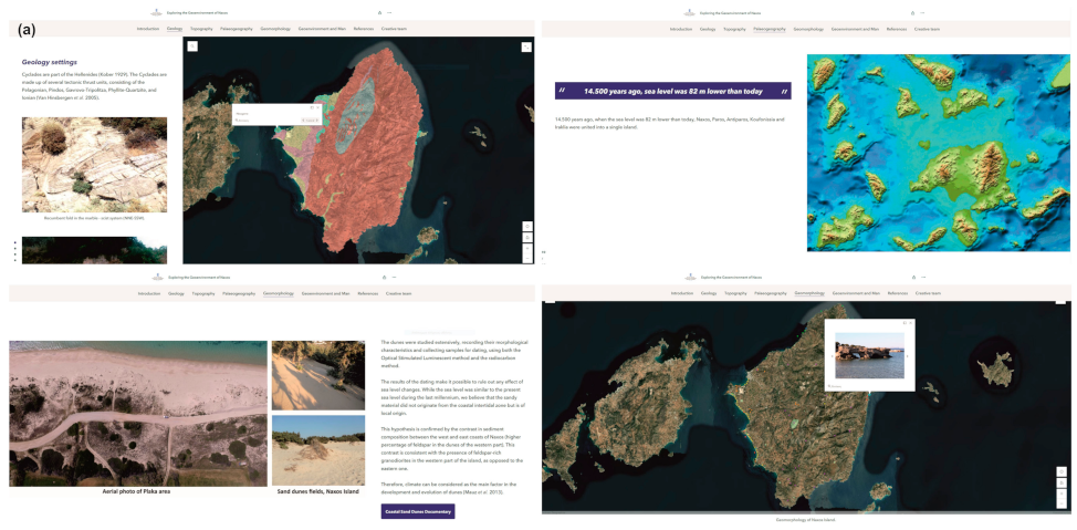
13] for the area was also used and all the collected material was accompanied by photographic material, drone photographs, videos, aerial videos and text. Using ArcGIS StoryMaps, different tabs/chapters were developed containing a number of thematic maps, which were accompanied by texts, videos and drone photographs, as well as external links to documentaries on the features presented (
Figure 1). The developed StoryMap is available at
https://arcg.is/1fqOyC (accessed on 16 June 2022).
We selected ArcGIS StoryMaps as a tool to develop our VFT because, although the main aim in this VFT was for students to better understand the geomorphic processes and landscape evolution, we also wished to increase their skills in mapping. The VFT that we developed helped students to become familiar with the area through multimedia material, text and interactive maps. We had the idea that, through interactive maps, it would be easier for geoscientists to understand better the processes in the landscape. Ιt is important to be able to navigate the area, to move beyond the narrow limits of a specific studied site, because often the processes taking place in the surrounding area affect the site being studied. GIS and interactive maps make this possible. Our students, through the developed VFT, could see the individual geomorphological features, change the scale of the map and move around it so that they could better understand the landscape. In order to provide a more comprehensive overview of the study area, a field trip guide was also composed, where one could find not only general geographical, physiographical, climatic, geological and geomorphological information about the island, but also information about the individual landforms. This information regarded their geographical distribution over the island and their formation processes in connection with the geomorphology and geology of the contextual study areas. Consequently, the virtual field trip was presented to 84 students for the CIVIS presentation and 134 third-year students attending Geomorphology.
Questionnaire Design
In order to obtain feedback from the students who attended the virtual field trip, an anonymous questionnaire was designed and given to the students to complete. We used ArcGIS Survey123 by ESRI, as it is a complete, form-centric solution for creating, sharing and analyzing surveys, using, at the same time, the geographical distribution of the sample. ArcGIS surveys are GIS-based surveys that produce real-time data in order to support decision-making. As a result, data analysis such as statistical calculations and data filtering is possible. Amongst the students attending the virtual field trip, 94 students completed the questionnaire created for this purpose, which can be found at
https://arcg.is/1nm8Hj (accessed on 16 June 2022). The questionnaire was designed so that students could assess the specific virtual field trip, the curriculum covered and virtual field trips in general. The first group of questions regarded the satisfaction of the students with the virtual field trip design and their input on the subjects covered during its duration (
Figure 2). This feedback was important as it would provide information on how the specific virtual field trip could be improved. Moreover, it was important to have feedback from the students regarding whether, during the navigation of the virtual field trip, the curriculum of the course was covered according to their expectations. The second group of questions examined the connection of the virtual field trip topics with other courses and subjects, since it was important to assess the multidisciplinarity of the curriculum (
Figure 2). The last set of questions regarded virtual field trips in general and aimed to gain an overview of the students’ perspectives of virtual field trips, their willingness to attend a similar one in the future and whether their educational needs were covered, taking into consideration the pandemic restrictions and their assessment in comparison to actual ones (
Figure 2). In addition, during the online course, small quizzes (
Figure 3) were used in order to assess how the participants understood the presented concepts. The questions tested the cognitive levels of the participants based on their acquired knowledge, their ability to understand what they heard and their ability to apply, analyze and synthesize the information presented. After the end of each quiz, a discussion of the results took place in order for the correct answers to be clarified by the participants.
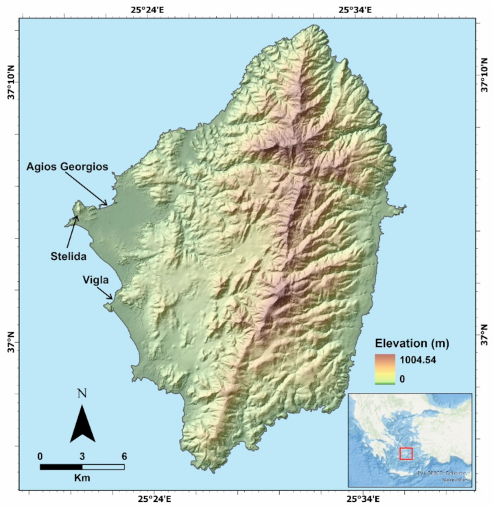
3. Study Area
The Aegean is a unique environment, regarding the active geodynamics, ongoing geological processes and dynamically changing landscapes due to the convergence between the Eurasian and African continental plates. The broader area of the Cyclades is a geotectonically active region, due to this convergence [
14]. The seismicity of the Central Aegean region is, however, not high, as large earthquakes are rare [
15,
16]. Naxos is located in the central Aegean Sea and belongs to the south Cyclades complex (
Figure 4). It is the largest island of the Cyclades, covering an area of approximately 428 km
2. The climate type of the area is Mediterranean, i.e., dry and long summers and mild winters. Storms are common during winter, whereas snow is very rare.
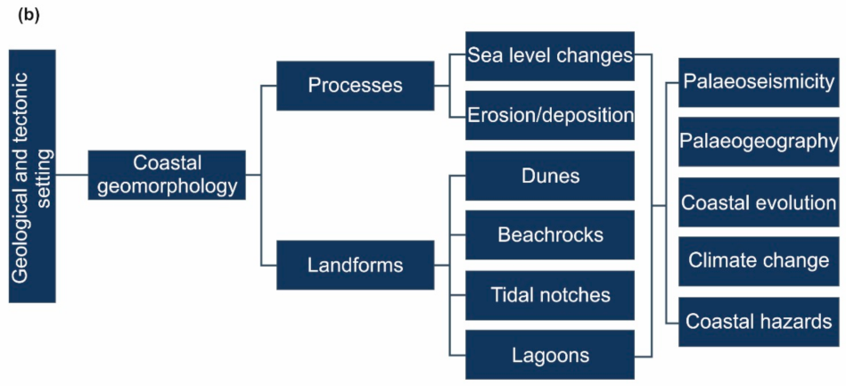
The coasts of Naxos Island, especially since the Late Pleistocene, are determined by eustatic sea-level changes, whereas vertical tectonic movements bear no significant impact [
14]; however, there are indications of tectonic control for the late Holocene in the broader area [
10,
17,
18]. Several submerged tidal notches have been identified in the southeastern Cyclades, which were attributed to former seismic events, which have taken place since 3300 BP [
10]. There are many submerged landforms and other indicators at Naxos, such as beachrocks found down to a depth of 6 m [
11,
13]. Given the fact that many geomorphological features are submerged, the virtual field trip was enriched with many photographs and videos of such features.
The lithology of Naxos consists of various lithological formations with different resistance in erosion. These differences, in combination with the action of the hydrographic network and tectonics, have determined the present morphology. Evelpidou [
9] has identified six lithological units, namely marbles–schists, migmatite, granodiorite, Neogene sediments, Quaternary sediments and colluvial–alluvial sediments. Marbles and schists cover the largest part of the island, namely the central, northern, southern and eastern parts, except for the migmatite dome in the center. Neogene, Quaternary and colluvial–alluvial sediments are almost absent in this part of the island and, alongside the granodiorite, they are abundant on the western coasts of Naxos [
9]. The students were introduced to the geology of Naxos through the StoryMaps, through interactive maps and images of particular lithologies, guided by the tutor.
3.1. Geomorphology
The relief of Naxos is mainly mountainous, especially its eastern, northern and southern parts. It is characterized by a mountain range with a direction of N–S. Its highest summit, Zeus, is found in the center of the range and reaches 1001 m, which is also the highest point of the Cyclades. The western part of the island is, on the contrary, flatter [
9]. Naxos has many landforms and geomorphological features that result from differential erosion [
9]. This geological and tectonic setting has led to the formation of several landforms, associated with several environments (e.g., coastal, lagoonal, aeolian, etc.) [
9]. This is the main reason that this region was chosen as a study area and as a virtual field trip destination. It has the potential to aid students in recognizing various landforms, whereas it can offer them information about their formation processes. Additionally, several sites present an intriguing palaeogeographical evolution during the Quaternary, which can further aid students in understanding the principles of geomorphology. Some characteristic landforms are noted in the following paragraphs and more information can be found on the virtual field trip.
3.2. Landforms
3.2.1. Tafoni
Although there are many tafoni sites over Naxos, the most characteristic tafoni and cavernous weathering formations appear in the Stelida area, developed on granodiorite [
12]. The cavernous weathering forms are found 25 m above the mean sea level. Evelpidou et al. [
12] have studied roughly 200 tafoni and honeycombs, regarding their geomorphological characteristics, mineralogy and geochemistry. Taking into account that the majority of the investigated honeycombs and tafoni present rock fragments in the form of debris and flakes, it appears that their evolution is still active [
12].
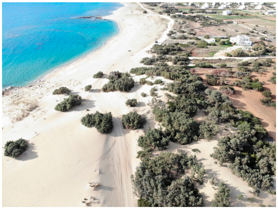
3.2.2. Sand Dunes
Sand dunes are common landforms along the western beaches of Naxos [
11,
19,
20]. They are usually developed in front of coastal lagoons, part of which lie below sea level. The sand dunes of Naxos are very important, not only due to their function as habitats, but also because they play a protective role against coastal flooding due to sea-level rise. Amongst the most characteristic dune fields in Naxos are those with cedar species (
Figure 5), belonging to the Natura 2000 protected areas.
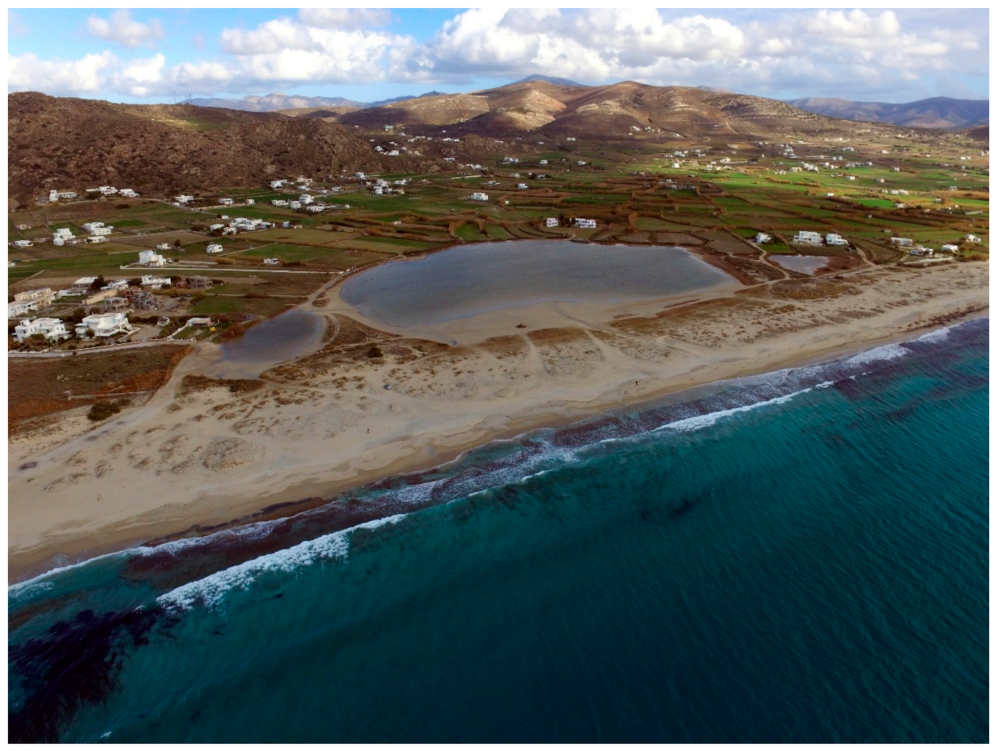
3.2.3. Coastal Wetlands and Lagoons
In Naxos Island, many lagoons have been formed in the western coastal zone. Two characteristic examples highlight the evolution of the western coasts during the late Holocene, Agios Georgios and Mikri Vigla [
11,
19]. For this reason, these sites were presented during the virtual field trip as they bear clear evidence of coastal evolution, using different landforms, such as lagoons and beachrocks.
At Agios Georgios, a series of coring revealed that the area was a lagoon 6000 years ago, while today, it is a wetland. This area used to be a harbor, as it was an active lagoon from at least 6144 BP until 232 BP, and probably served Yria at that time [
19]. Underwater beachrocks in the bay of Agios Georgios represent fossilized shorelines of 1500 years ago and 3400–4500 years ago [
13]. Today, these beachrocks protect the coast from erosion due to wave action and sea-level rise.
A few kilometers to the south, the Vigla area is characterized by low land morphology crossed by torrents of temporary flow, coastal lagoons, dunes and sandy beaches (
Figure 6). In the Vigla area, two beachrock benches, along with sand dunes, represent the dominant coastal landforms. The analysis of sediments and micro-faunal content from Vigla corings revealed that during 3800 BP to 1625 BP, the area of Vigla was an active lagoon [
19]. At least during the Bronze Age (3300 BC–1200 BC), Vigla may have been a place where boats could anchor.
3.2.4. Tidal Notches
Tidal notches form through bioerosion by several endolithic and epilithic organisms that reside near the mean sea level and are mainly found on carbonate cliffs [
21,
22]. They form near the mean sea level, which means that they can offer information about paleo-sea-level changes, if found uplifted or submerged [
23].
In Naxos, there are several sites where tidal notches are found, primarily on the NE and NW coasts, reaching depths of up to 2.8 m [
10]. Evelpidou et al. [
10] have identified seven submerged tidal notches in several islands of the central Cyclades, including Naxos, at depths of between 280 ± 20 and 30 ± 5 cm below the present sea level. The subsidence of the uppermost notch at −30 ± 5 cm was attributed to the global sea-level rise during the last two centuries and, at least partly, to the 1956 Amorgos earthquake [
10]. The deeper coastlines are probably due to repeated subsidence events and not to gradual subsidence [
10]. These landforms were selected for the virtual field trip as they testify to the tectonic regime of the area; they provide information on the seismicity of Naxos, while revealing the impact of ancient earthquakes on coastal civilizations.
3.2.5. Beachrocks
Beachrocks are common coastal landforms formed through the rapid cementation of beach material, the cement usually being aragonite and high-magnesian calcite [
24].
In Western Naxos, a series of extensive submerged beachrock slabs may be found, reaching depths of approximately 6 m. Multiple analyses of beachrocks, sediment coring and archaeological data suggested that the relative sea level rose by at least 3.8 m in the last 4.0 Ka and that relative sea level variations in the last 2.0 Ka did not exceed 2 m with respect to the present mean sea level [
13]. These features were selected for the virtual field trip as they are amongst the most representative beachrocks in the Cyclades in terms of extent, bearing clear evidence of the evolution of the coastline for the last few thousand years.
3.3. Coastal Erosion
Although there are many places around the globe that are facing coastal erosion, in Naxos, this phenomenon is rare, even though it has a very sensitive coastal zone, with several sites with unstabilized sand dunes and a lagoon behind. The reason is that beachrocks are developed parallel to the coastline, along most of the shoreline, acting as a protective agent against wave action, for the sensitive coastal zone. The site of Agios Georgios provides a clear view regarding the role of beachrocks as natural breakwaters, i.e., a natural protection for thousands of years, which inspired the experimental research on artificial beachrocks [
25,
26]. This topic was presented in the virtual field trip as an innovative experimental solution to coastal erosion.
4. Results
The virtual field trip was realized in approximately 3 h, directed by a tutor. The virtual field trip was designed to stand with the presence of the tutor, who encouraged students to examine landforms and landscapes and comment on and discuss the features presented during the field trip. Hence, the students had direct contact and communication with the tutor for the whole duration. During the virtual field trip, students were asked to take small quizzes after each topic was presented and discuss them, to have a better idea of their understanding of the presented curriculum.
Amongst the students who attended the CIVIS virtual field trip and the mandatory course of Geomorphology, 94 filled in the questionnaire (
Figure 7). The vast majority (90.4%) found the overall trip interesting and it aided their understanding of the principles of geomorphology. Moreover, 81.9% also found that there was adequate connection with other courses aside from Geomorphology, and 89.4% stated that the means of this field trip was satisfying, given the COVID-19 restrictions. A few of them (44.7%) had attended another virtual field trip before. It is worth mentioning that 35.1% of those who had attended another virtual field trip before were the students of Geomorphology, given that another virtual field work project had taken place shortly before this one [
27]. Almost all of the students (93.6%) stated that they would attend another virtual field trip in the future, even if the restrictions are abolished, as trainees and in order to prepare themselves for an actual field trip. The main reasons for this are, according to them, the ability to view satellite images of previous time periods (62.8%), to panoramically view an area (56.4%), the easy usage/performance (47.9%), the ability to view areas in three dimensions (42.6%), the fact that virtual field trips are time- (40.4%) and money-saving (38.3%) and other reasons. Overall, 91.5% of the students would use VFs in order to prepare themselves for actual field work, whereas 86.2% would use virtual field trips, as educators, instead of other common teaching methods such as PowerPoint presentations.
The students were asked to freely comment on the specific field trip, as well as virtual field trips in general, as opposed to actual ones. Here, 31 of them (33.0%) commented on and mentioned several drawbacks of virtual field trips. The most frequently mentioned ones included the difficulty/inability to understand the principles taught through a virtual field trip as opposed to an actual one (19.4%), the limited interaction between students, educators and/or nature (16.1%), the inability to observe superficial features (e.g., landforms) in detail (16.1%) and the inability to collect samples (e.g., of rocks) and/or perform in situ measurements (16.1%). Moreover, 25.8% of them stated that a virtual field trip does not provide them with the knowledge, experience, skills, familiarization with the field, etc., that they will need as future geoenvironmentalists. Finally, when asked if virtual field trips can substitute actual ones, only 17 out of the 94 students (18.1%) answered positively.
5. Discussion
One of the main purposes of this virtual “excursion” was to train our students on coastal evolution, paleogeographic reconstructions, sea-level changes and geoarchaeology. Therefore, through this virtual navigation, we intended to show the students some of the main landforms of the island of Naxos and correlate them with the geological and geomorphological setting of the contextual area of interest. Through the ArcGIS StoryMaps application, they had the ability to observe geological, geomorphological and relief maps, photos, satellite images, etc., thus combining the optical factor with their previous geological knowledge and the lectures during the virtual field trip. An important aspect of StoryMaps is the availability of interactive maps. Students are able to freely interact with all the available maps within the developed virtual field trip and obtain geographic and descriptive information for each site, as well as multimedia material (i.e., photographs, videos). This is in contrast with the development of a virtual field trip through Google Earth web or other types of VFTs that do not allow the use of interactive maps using multiple information layers.
As mentioned above, most students were intrigued by this virtual field trip and were aided in understanding the principles of the course of Geomorphology. Additionally, they found it to be a useful means of preparing themselves for live field work. However, as most of them mentioned, virtual field trips can only be used supplementarily and not as substitutes for actual field trips. After all, this is, or should be, how virtual field trips are used [
7]. They can, however, offer students a more interactive experience than other commonly used educational methods (such as PowerPoint presentations)—that is, they should be used in the classroom as an alternative teaching method [
8,
28]. This approach may add to the training in the field, as students; when they visit the field afterwards, they will already be familiar with the study area and have understood the prevailing processes. Therefore, time in the field can be devoted to methods and techniques such as mapping, coring, etc., which are all used for geomorphological research in an area.
Virtual navigations are a very useful tool, offering many opportunities when preparing for a physical visit to an area. Initially, one can determine the sites of interest that are to be visited for sampling collections, field measurements, etc. Furthermore, one can use them to create maps, which can later be corrected, once the said sites have been visited. This can also happen vice versa, i.e., through a virtual field trip, existing data from the field can be reconsidered. Moreover, in this way, remote and/or dangerous sites such as cliffs can be safely visited [
3], and most regions can be panoramically viewed, whereas persons with mobility limitations can also participate in virtual navigations [
1,
29].
However, they cannot act as a substitute for real field work [
7], and they have several limitations for students [
30,
31]. They are deprived of interaction with each other, with the educators and, mainly, with nature, whereas this would not be the case for live field trips [
2,
7]. Even when the former is achieved, interaction with nature is restrained. Students cannot, for instance, use all their senses, namely vision, hearing, smell, touching or even tasting, as the main purpose of a field trip is this interaction [
5,
32]. Another aim of field trips is usually the understanding of the principles of geoscience courses taught in the classroom. This can be achieved to a greater extent in the field than in the classroom. Students can be greatly aided in understanding the geological, geomorphological and other natural processes when in the field [
1], while a field experience can be recalled and remembered by most students, as opposed to a classroom lesson. One significant advantage of virtual field trips is the preparation of students for the actual one. By guiding the students through a virtual field trip to the study area or the sites that they will be visiting during the actual activity, tutors have the opportunity to provide all the necessary tectonic, geological and geomorphological background necessary so that, when in the field, more practical activities can take place. For instance, during a virtual field trip on the paleogeography of an area, the tutor can present interactive maps with the evolution of a particular area and, in the field, show the students how coring can take place.
6. Conclusions
Virtual field trips are a very significant tool for field work preparation, as well as a very effective teaching method. This means that they can be beneficial for both students and researchers. They can aid the actual field work in many ways, whereas they are a very interesting experience for students. They can be more effective than common teaching methods and they can aid the understanding of the fundamentals of geology, geomorphology, physical geography and other geosciences. They are also very helpful when performing investigative field work. However, they cannot take the place of actual field trips, as they are not as interactive as the latter, thus rendering them less effective. However, they can significantly support the realization of actual ones; they can be used as introductory tools to the tectonic and geological elements, the geomorphic processes and landscape evolution of a particular study area or site before the actual field trip. Therefore, time in the field can be devoted to methods and techniques such as mapping, coring, etc., which are all used for geomorphological research in an area.


 ,
, 


