
Ecclesiastical Economies: The Integration of Sacred and Maritime Topographies of Late Antique Cyprus


Department of Late Antique and Byzantine History of Art, Ludwig-Maximilians-Universität München, 80331 Munich, Germany
Religions 2021, 12(11), 989; https://0-doi-org.brum.beds.ac.uk/10.3390/rel12110989
Submission received: 30 August 2021
/
Revised: 31 October 2021
/
Accepted: 2 November 2021
/
Published: 11 November 2021
(This article belongs to the Special Issue Unlocking Sacred Landscapes: Religious and Insular Identities in Context)
Abstract
:This article focusses on the relationship of the church with productive landscapes and coastal topographies within numerous Cypriot contexts of the 4th–8th centuries. Through synthesising the archaeological research and architectural remains of these aspects and categories, the coastal settlements of the island are recontextualised in terms of their mercantile, religious, and cultural networks, on inter- and intraregional scales. The advantages of researching late antique insular societies on local, individual scales and within economic contexts are therefore highlighted. These integrative approaches can illuminate the constructions of religious identity across many coastal contexts, particularly in larger islands with micro-regions and trans-Mediterranean connectivity, like Cyprus. By considering the importance of the administrative and economic roles of the late antique church within these maritime topographies, future archaeological research can integrate both the monumentality and pragmatic aspects of sacred landscapes.
Keywords:
Late Antiquity; Cyprus; economy; sacred topography; churches; landscape archaeology; Early Byzantine1. Introduction
The transformation of agrarian landscapes to incorporate ecclesiastical aspects introduced conceptual boundaries within which settlements operated, communicated, and associated. This article aims to emphasise the advantages of integrating economic and administrative aspects of the church in studying Late Antique archaeology, with a focus on the non-ecclesiastical roles of coastal churches of Cyprus in the 4th–8th centuries. By compiling examples of the ecclesiastical relationships with local economies and productive landscapes, including aspects such as the pilgrimage industry and copper mining, this article considers the pertinence and importance of the economy in Christianised landscapes and coastal topographies. Often described as a crossroads in the eastern Mediterranean, Cyprus’ maritime connections, vast Christian topography, and eventful late antique history culminate in an expansive region with numerous combinations of civic and liturgical complexes (for Cypriot churches of Late Antiquity throughout the Middle Byzantine period, see Maguire 2012; Papacostas 1999; Megaw 1974; Papageorghiou 1985; Chotzakoglou 2005; Stewart 2008). The following endeavours to supplement the study of late antique Cyprus in regard to coastal archaeology and the church’s maintenance of regional supplies, both in maritime networks and hinterland systems.
1.1. Research Context and Methodology
Research on Early and Middle Byzantine churches focusses on architecture, decoration, and historical sources, neglecting non-liturgical annexes and aspects, resulting in various misunderstandings of the Late Antique church (Megaw 1974; Chotzakoglou 2005; Papageorghiou 1986). Earlier scholarship includes the interpretation of the Arab invasions of the 7th century as a catastrophic watershed moment, and as a means to distinguish the Early Byzantine period (4th–7th centuries) from the period of neutrality (7th–10th centuries), but recent research argues for continuity after the Arab raids (Kyrris 1997, pp. 631, 651; Chrysos 1993, pp. 10–11; Metcalf 2009, pp. 202, 277, 474–75; Armstrong 2009; Gabrieli et al. 2007; Rautman 2003; Winther-Jacobsen 2010; Zavagno 2017; Megaw 2007, pp. 121–31, 136). Regarding Late Antique Cyprus, few studies have placed importance on the economic roles of the church until recently (Parani 2013; Papacostas 2001; Rautman 2014; Metcalf 2009; Vionis and Papantoniou 2017; Papantoniou and Vionis 2018; Kyriakou 2019). This is partly as a result of the archaeological attention paid to monuments such as basilicas and wealthy villas, including research from Maguire, Nicolaou, and Papacostas (Maguire 2012; Nicolaou 2013; Papacostas 1999). In recent decades, excavations and Late Antique studies have investigated the social, religious, and economic contexts of Cypriot churches, shedding light on their architectural, ceramic, numismatic, and sigillographic material as well as their topographical settings (Kyriakou 2019; Papantoniou and Vionis 2018; Rautman 2003; Metcalf 2009; Gabrieli et al. 2007; Given 2018; Stewart 2008; Randall 2013). These studies have extended dates of the use of these churches and sites into the 8th century, which is therefore used as a chronological parameter for this article.
By investigating the administrative and economic motivations of the period, progress can be made within methodological approaches to insular communities and identities. This article synthesises archaeological research and landscape studies to provide an overview of late antique Cyprus and highlight the nuances of similar integrated approaches concerning its sacred coastal topographies. In compiling material corroborating the administrative and economic roles of the coastal Cypriot church, various categories and contexts have emerged: general monumentality and administration in urban centres, subcategories of regional distribution and trade (emporia and warehouses, cabotage, agro-towns, markets and shops, and pilgrimage). The following article surveys these categories and closes with a consideration of the distribution of churches throughout the copper mining landscapes.
The conceptual and theoretical frameworks for this article connect the insularity of Cyprus with maritime connectivity and island archaeology generally. In ongoing revisions of previous scholarship on the dichotomies of urban or rural, collapse or continuity, and ecclesiastical or secular, it is possible to advance knowledge of third spaces and peripheral contexts in coastal topographies and Christianised landscapes (Preiser-Kapeller and Daim 2015; Zavagno 2017; Veikou 2009; Horden and Purcell 2000).
The diverse terminology for harbours in antiquity and the Byzantine world demonstrates the importance of maritime connectivity and trade, including the varying degrees to which port installations changed the topography. One such example is the visibility of the Theodosian harbour in Constantinople (Berger 2015). These categories encompass small natural bays, built anchorages, and large commercial centres with breakwaters and facilities to store cargo (Veikou 2015, pp. 39–40). Agency and connectivity may have influenced which sites modified their urban landscape to access the coast and which refurbished port amenities from antiquity to the Byzantine period.
Scholarship regarding the Christianisation of Mediterranean settlements often denotes the prominence of churches as a form of announcement of the communal religious identity to those approaching (Häussler and Chiai 2020, p. 2; Vionis 2019, p. 78). Whether these monuments encircle a region on hilltops or feature at the liminal space of the harbour, a message can be broadcast by their placement and use of imported marble decoration. The earlier foundation of episcopal basilicas within antique cities occupied the peripheral or available quarters, i.e., near city walls (for example, Church E at Sardis (Jacobs 2012, p. 133)). The multifaceted transformation of the classical city involved modifications of temples, theatres, and civic structures into basilicas, and placement in more visible and important locations such as harbours (Jacobs 2013; Kyriakou 2019, p. 47).
As mentioned by Zavagno, the “archaeology of power” concept is relevant here for understanding the strategies deployed by elites or others at the top of social strata: material remains revealing the structures and actions of those with power can be interpreted within the framework of the church’s standing and influence (Fernández Delgado et al. 2013, p. 164; Zavagno 2017, p. 34). Reinforcing and maintaining political and economic control through land ownership manifests in the foundation of settlements, complexes, and buildings, which display power or status through control of productive facilities. When considered in connection to factors like the financial undertaking of building sanctuaries and political circumstances of the island, these monuments and landscapes become more complex (Papantoniou 2013, pp. 44–49).
Examining the local choices in institutions and processes provides a more precise model for understanding human agency or deference to established imperial or religious authorities, and reactions to political events (locally and in Constantinople). The multifaceted nature of ecclesiastical complexes demonstrates the pragmatic and individualized situations of each settlement, ranging from monumental visibility within the landscape to small-scale agricultural production. In analysing the other roles and involvements of churches on the coast of Cyprus, more information can be supplied to ongoing discussions of longevity of occupation, connectivity, orientation toward other regions, and Christian historical contexts like autocephaly and synods (Zavagno 2017; Veikou 2015, p. 49).
1.2. Late Antique Cyprus
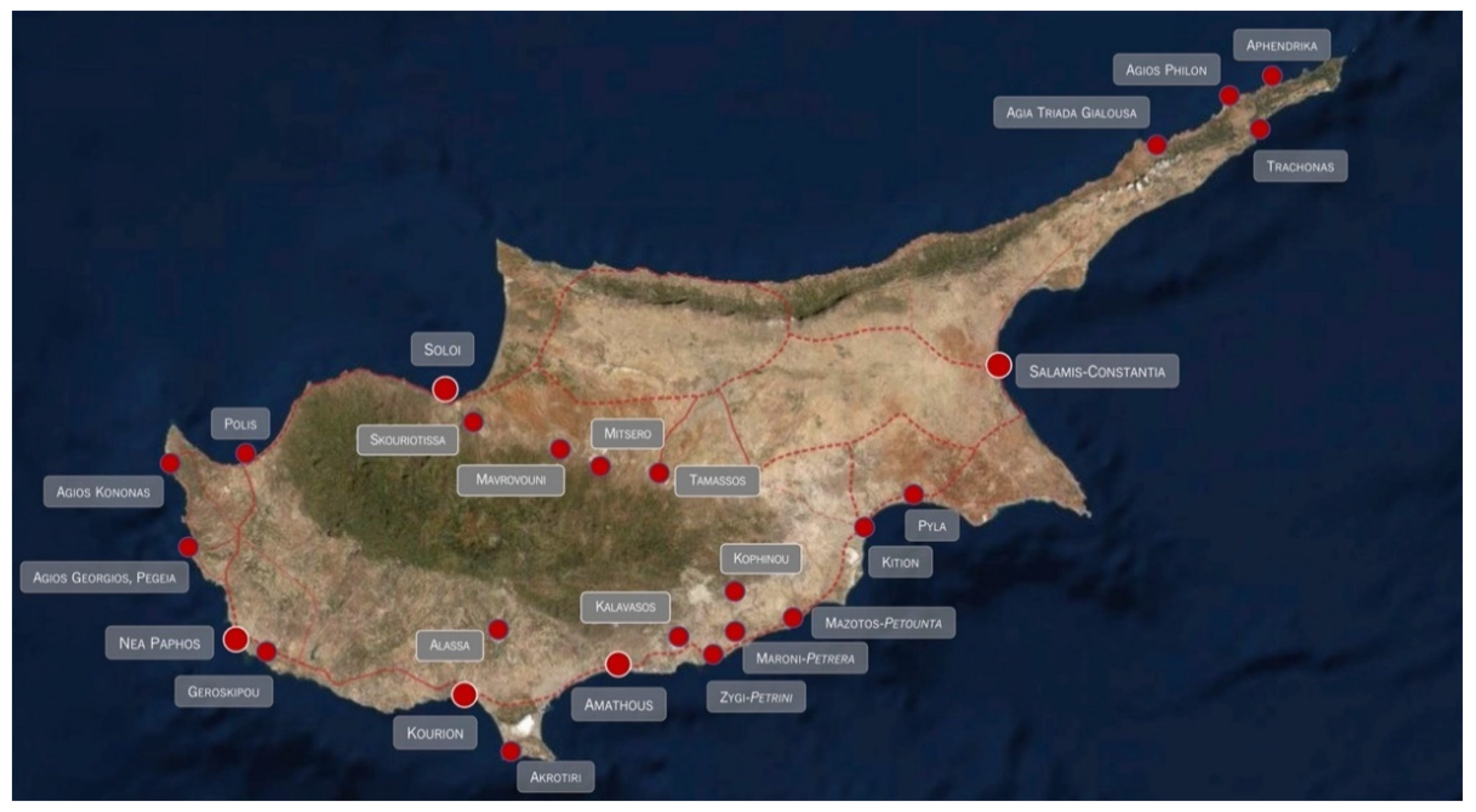
In Late Antiquity, Cyprus was a wealthy, independent island that was able to build its importance through diverse trade relations as a maritime crossroads. Its socioeconomic and cultural development was shaped by invasions and earthquakes, but also by trans-Mediterranean contact and the lively cult of saints and bishops from the earliest years of Christianity (Deligiannakis 2018). As Christianity developed in the eastern Mediterranean, the Church established a great influence over the island, as evidenced by numerous large 4th–6th century basilicas and the formation of many bishoprics (Figure 1).
The church-building of Late Antique Cyprus can be briefly summarised by century following the earthquakes of the mid-4th century. In the late 4th and 5th centuries, many large urban churches were established (Megaw 1974; Papageorghiou 1985). The Roman cities and towns underwent a shift in their topography with these new basilicas encroaching on the forum, city edges, or ports. By the 6th century, Cypriot settlements saw many modifications of their basilicas and construction of even more churches, at least partly due to the new administrative power of the clergy (Kyriakou 2019, p. 50). In the later 5th and 6th centuries, rural and remote churches became more common, which may mirror the shifts in agrarian dispersed populations, the general wealth of the urban centres, and the political stability of the island (Papantoniou and Vionis 2018, pp. 19–21). Examples of these churches outside of metropolitan areas are Kalavasos-Kopetra, Panagia Angeloktisti in Kiti, and Kophinou (Rautman 2003; Papantoniou and Vionis 2018). Renovated and new urban churches of this period include the acropolis basilica in Amathous, Panagia Chrysopolitissa in Nea Paphos, and Soloi (Aupert 1996; Papageorghiou 1986; des Gagniers and Tinh 1985). New churches in the 7th century include one of those at Kalavasos-Kopetra and the monumental double basilica at Katalymmata ton Plakoton (Procopiou 2014). The establishment of new basilicas and architectural innovations of the 7th and 8th centuries (on the Karpas Peninsula, St. Lazarus in Kition, etc.) dispute the prior understanding of the Arab invasions as devastating or paralysing (Stewart 2008).
From coastal to inland communities, the church had many obligations and roles in Late Antique Cyprus. Throughout the Mediterranean, the administrative, juristic, and civic duties were taken over by bishops and clergy (as in the Novellae of Justinian (128.14) Schoell and Kroll 2014; Rapp 2005, pp. 6–16; Angold and Whitby 2008, pp. 573–74; Wickham 2005, pp. 153–258). Revenue and land ownership as factors in the relationship between a church and the surrounding community both influenced and were influenced by its placement and behaviour within the settlement.
The rural wealth traced through the 6th and 7th centuries relied on the association of a community with a church, as from the Middle Byzantine period onward, many of the countryside basilicas were funded by a personal patron (Papacostas 2015a, 2015b); for rural land use strategies of the 7th century, (see Given et al. 2013a, vol. I, pp. 334–35; Rautman 2000, p. 318). The multiple roles and contexts of churches in the Byzantine Mediterranean are present in Cyprus: necropolis churches, monasteries, martyr shrines and pilgrimage churches, episcopal basilicas, churches established over or next to pagan temples, and those placed at harbours or near production sites. These coastal urban, extra-urban, and hinterland Christian sites demonstrate the complexity of the sacred topography.
Integration of churches into the economic networks of the island can be traced through the materials present, the routes on which they lay, and their placements within the landscape. Olive oil and wine properties of the south coast similarly directed their communication and produce through the nearby ports and trade routes, along which churches were built. For the copper mining of the foothills and Troodos Mountains, the settlement topographies follow the natural resources of ore, water, and timber, and the most direct communication routes for cumbersome products such as ore and metal. As demonstrated in Soloi’s hinterland, discrepancies existed between mining communities’ administration and whether the product was intended for long-distance export to the imperial mints or for local entrepreneurs (Winther-Jacobsen 2010, p. 84; Graham et al. 2006, p. 361; Given et al. 2013a, vol. I, pp. 329–30; 2013b, vol. II, pp. 197–98; Kassianidou 2000, p. 751). The latter, at Litharkies and Mavrovouni, is not dependent on the landscape placement: being further inland than Skouriotissa and Soloi is not a factor as the mines of Mitsero were located even more centrally within Cyprus. The presence of churches matches the communities at the points of resource extraction, the areas of workshops, routes of export, and coasts. This economic topography therefore becomes a sacred one through its management and control by the church.
2. Ports and Christianity
The association of monumental basilicas with harbours in Late Antiquity is well-known, where the church acts as a beacon, protector of sailors, and preeminent landmark in the urban topography for both locals and visitors. In Cyprus, this is clear in copper mines and workshops (Skouriotissa, Mitsero and Tamassos (Kassianidou 2000; Given and Knapp 2003, p. 74)) and olive oil presses (Hadjisavvas 1992), as creating workshops and settlements on the spot is more efficient than conveying and processing material centrally (Bintliff 2012, pp. 272, 357). While many Late Antique anchorages and ports in Cyprus have not survived or been researched, major sites such as Salamis, Nea Paphos, Amathous, and Kourion all have portside basilicas characteristic of this protective function. A 6th century basilica in Agios Georgios, Pegeia contains an ambo inscribed with “+ ΥΠΕΡ ΕΥΧHΣ ΝAΥΤΩΝ”, or “in the fulfilment of the vows of sailors”, an epigraphic practice not unknown in Mediterranean dedications, establishing the nautical connection (Michaelides 2001; Nicolaou 2016, pp. 316–18). Another inscription is a graffito of a ship carved into a masonry block at the 6th century basilica of Pyla-Koutsopetria in southeast Cyprus (Christou 1994, pp. 689–90; Leonard 2005, p. 428). These coincide with the new status and stronger agricultural production role for Cyprus within the Justinianic Questura Exercitus of 536 CE (Lokin 1986). The visual and practical roles of these structures are considerable, including the management and redistribution of imported goods and the presence of warehouses, markets, fairs, and coastal regional trade (Leonard 2005, p. 564; Papageorghiou 1986).
Many Late Antique Cypriot basilicas were established on harbours or coastlines, or prominent on a hilltop, visible from the water. Of the former, the church at Agios Philon was to be protected by inclusion within the later reduced city walls, and one of the churches of Polis-Arsinoe was constructed against the fortification tower close to and overlooking the harbour (du Plat Taylor and Megaw 1981; Najbjerg et al. 2002). The latter category comprises many elevated examples, understandably so given the importance of the maritime routes and communication networks of the 4th–8th century. These basilicas could be observed as beacons or landmarks due to their strategic locations on both sea and land routes. They ranged from monumental centres (Soloi, Amathous, Nea Paphos, Salamis, and Kourion) to the smaller-scale (Karpas peninsula, Pegeia, Agios Kononas, Pyla-Koutsopetria, and Mazotos), as well as those constructed or refurbished in the late 6th to late 7th centuries (Agios Lazaros in Larnaca, Soloi, and Akrotiri). The argument that the coastal locations of the Late Antique sites made them easy targets for the mid-7th century invasions is easily supported by mapping these numerous basilicas—many of which are within a few kilometres of the sea.
The ubiquity of basilicas as monumental landmarks in harbour settlements of all sizes is evident throughout the Mediterranean, including Cyprus. In Amathous, four churches encircled the lower town, relatively densely spaced 250–500 m from each other (Aupert 1996; Empereur 2018; Procopiou 2006, 2013). The main coastal road network passed by these churches and through the lower city, indicating their repetitive visibility and centrality. Evenly spaced around the harbour, the churches also demonstrate an ecclesiastical prominence and presence along the routes of regional distribution of goods from larger harbours along the southern coast to smaller ports. The episcopal church potentially had its own anchorage east of the larger port (Empereur and Kozelj 2017; Empereur 2018; Vionis and Papantoniou 2017, p. 280; Kyriakou 2019, pp. 53–54).
Distributive hubs, such as Dreamer’s Bay on Akrotiri, were in use for storage from the 4th century CE onwards, relaying produce on a micro- and macro-regional scale (Figure 2). The warehouses at Dreamer’s Bay appear to have played a role in the collection and distribution of interregional goods, likely sustaining the communities of the south coast such as Kourion (James and Score 2016). The area contained numerous sites of both ecclesiastical and secular nature in the late antique period. The basilica caves of Lania and the early 7th century martyrium and double basilica of Katalymmata ton Plakoton establish the continued occupation of the southern areas of Akrotiri and the religious communities using the harbour facilities (Procopiou 2014, 2015; Christou 1997, p. 902). For pilgrims and travellers along the south coast of Cyprus, these churches give Akrotiri a sacred character in addition to its commercial functions. Roman and Late Roman sites across Akrotiri signal a widespread population, or an “integrated maritime cultural landscape”, not just seasonal warehouse labour (James et al. 2021, p. 18; Kaldelli 2008, p. 200). In this sense, the peninsula and its hinterland can be studied as an entity, rather than examining Dreamer’s Bay as a “discrete ‘site’” (James et al. 2021, p. 5). Future research of Cypriot coastlines can be informed by this approach, incorporating the regional scale of study with the connectivity and monumentality of the immense martyrium of Katalymmata.
Nea Paphos resembles Amathous in its thoroughly Christianised urban landscape, enclosing the harbour with a basilica on either side, in addition to those elsewhere in the settlement. Another church has been identified at the harbour, between Panagia Limeniotissa and Panagia Chrysopolitissa, under the later “Saranda Kolones” castle (Hayes 2003, p. 449). It is unknown whether this church existed contemporaneously with the 7th century glass kiln under the castle, but the 7th century large marble plaque deposited in one of the castle’s wells may have belonged to the basilica. The spatial arrangement of the three basilicas evenly around the harbour is also telling of a unified monumental Christian landscape, among the other churches like so-called “Garrison’s camp” church and Shryvallos in the upper Ktima area (Giudice et al. 2017; Michail 2018, p. 166).
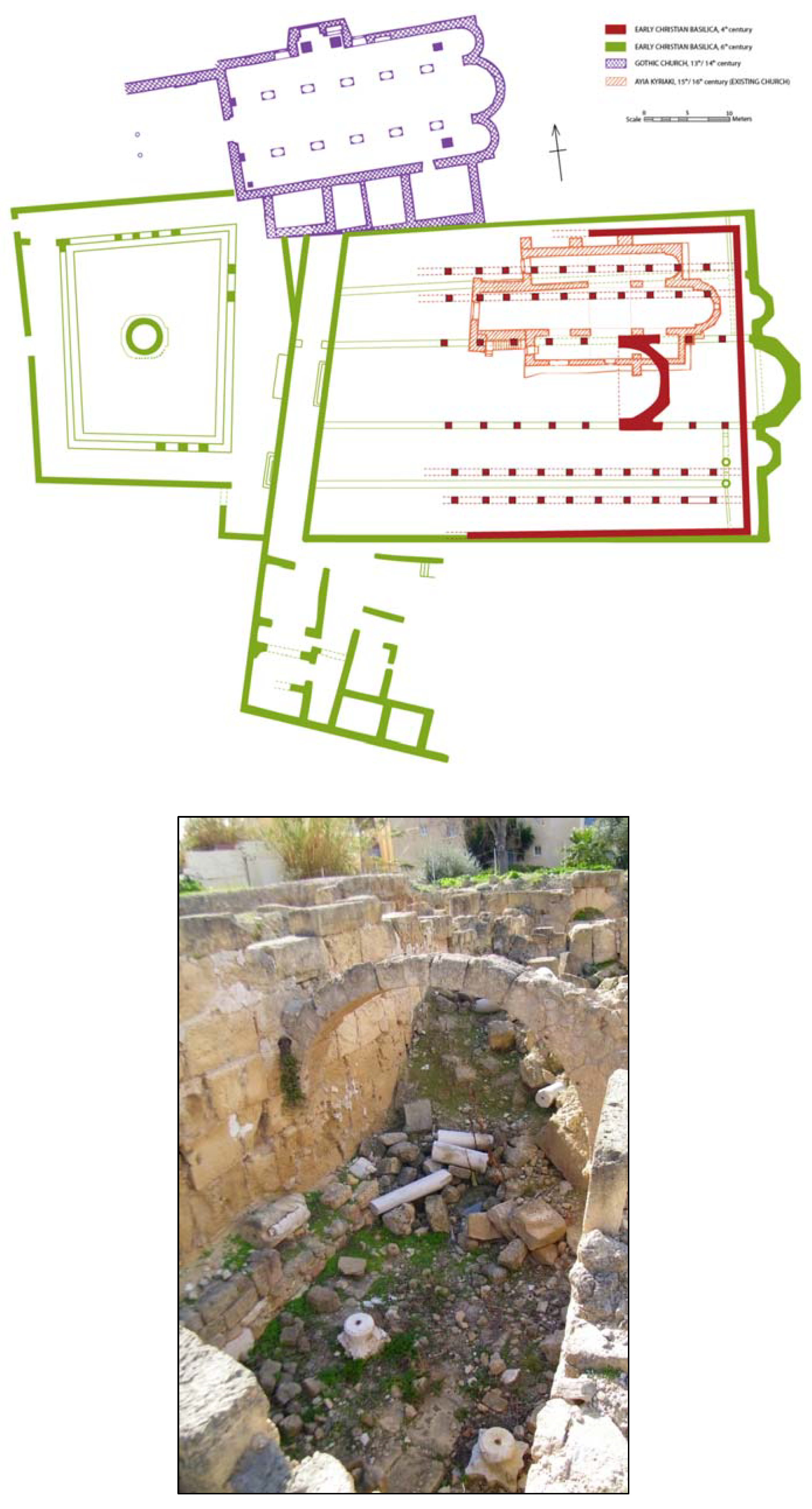
At Panagia Chrysopolitissa, the so-called bishop’s residence is situated between the basilica and the Hellenistic harbour (Figure 3) (ARDAC 1967, p. 18; ARDAC 1968, pp. 17–18; Karageorghis 1960, p. 292; 1968, p. 351; 1969, pp. 564–66; AR 1968–1969, pp. 53–54; Papageorghiou 1969, pp. 82–88; 1985, p. 318; 1986, p. 501; Megaw 1988, p. 140, n. 12; Maier and Karageorghis 1984, p. 301). This residence has not been fully excavated due to its depth—at least 3 or 4 metres lower than the floor level of the basilica. Two of the parallel spaces have doorways at this lower level facing the harbour and might have functioned in the Hellenistic or Roman periods. This building’s alignment with the narthex of the basilica indicates that it either predated or was contemporary with the basilica, but also dictated it, via the continued alignment into the construction of the narthex. The atrium and basilica then accommodated the narthex by the sharp angle in the southwest corner of the basilica and the extra northeast wall of the atrium. That both the 4th and 6th century phases of the church align with the residential building indicates that the 4th century basilica communicated with the residence either while it was still used in a secular way, or that it was already modified into a clerical residence. This interpretation is tentative pending further research and publication, but the reuse and modification of the Hellenistic or Roman spaces as an ecclesiastical residence demonstrates the pragmatic factors of basilica construction and placement in this central commercial location.
The basilica’s immense size dominated the cityscape as viewed from the sea. Its construction in the available space near the harbour occurred during a period of high mercantile activity in late antique Cyprus. The lavish villa mosaics in the southwest area of Nea Paphos, and the churches, theatre, and agora demonstrate the prosperity and centrality of the city, due to its role as a capital and the historical Palaipaphos. The basilicas and the repairs to the Roman houses attest to the growing wealth of Nea Paphos in the 5th and 6th centuries. In addition to the numerous industries of Nea Paphos (copper, ship-building, olive oil, and amphorae production), it has been suggested that in the 6th century, the city also participated in the trade of silk (Maier and Karageorghis 1984, p. 295). The basilicas were deliberately constructed as visibly and centrally as possible, and not just in urban areas that were vacant in antiquity. The monumentality of the harbour and the surrounding two or three basilicas, and the economic and cultural importance of the city, confirm Nea Paphos as a significant coastal centre and reflect known protective, administrative, and symbolic aspects of many Christian complexes (Vionis 2017, pp. 149, 158; Kyriakou 2019, p. 52). These administrative and symbolic roles may have been enacted by the churches surrounding the harbour, as focal points amidst civic and mercantile activity. Panagia Chrysopolitissa functioned as a visual monument integrated into the Late Roman city, adding to Nea Paphos’ historical role as first port of call for imports into Cyprus.
Fifteen kilometres north of Nea Paphos, the unidentified site referred to as Agios Georgios in Pegeia reached a height of occupation in the 5th–7th centuries (Bakirtzis 1996, 2001, 2003). Its three 6th century basilicas were decorated with Proconnesian marble and accompanied by a baptistery, accommodation, clerical residence, and olive oil production facilities. Constantinopolitan marble furnishing as a compensation for basilicas funded by profits from local products and harbouring of annona ships is already known at Karpathos in the Dodecanese (Deligiannakis 2016). The excavator suggests a link between this site and the imperial grain supply, based on the marble and its location on the west coast of Cyprus, on a shipping path between Egypt and the Aegean (Bakirtzis 1995). By recontextualising the site in terms of the island Geronisos (280 m west) and nearby Nea Paphos, an alternative perspective is also possible. The presence of a small-medium potential harbour more than 1.3 km away, past numerous suitable havens, indicates that if Agios Georgios participated in the grain supply at all, it was likely one of many sites including Nea Paphos and Akrotiri. It has also been noted that the majority of the site is unexcavated and would therefore surpass the needs of a small stopover station (Michaelides 2001, p. 53). The workshops and accommodation at basilica A, the olive oil press in the annexes of basilicas C, the bathhouse between these two basilicas, and religious activity on Geronisos tie the site to its hinterland and to pilgrimage (Bakirtzis 2020, p. 28; Bakirtzis 2001).
3. Regional Distribution and Trade
The varieties of production, distribution, and consumption are primarily visible in the coasts and hinterlands of Cyprus. Political circumstances of the past fifty years have resulted in more archaeological attention on the south coast, illuminating numerous coastal settlements and their cabotage. While this has caused an unbalanced view of the island, ongoing research such as ceramic studies and underwater surveys continue to contribute data to the field. This prioritisation of the south coast is partly due to the thorough publications of the Vasilikos Valley (Rautman 2003; Todd 2004), Kourion’s episcopal basilica (Megaw 2007), the Amathous harbour (Empereur and Kozelj 2017; Empereur 2018), the Maroni-Petrera basilica (served by the anchorage at Maroni-Vrysouthkia) (Manning and Manning 2002; Manning and Conwell 1992), the LR1 ceramics kiln at Zygi-Petrini (Manning et al. 2000), and Pyla-Koutsopetria (Caraher et al. 2014), and partly due to the unavailability of the north coast.
As will be discussed below, the prominence of basilicas in both smaller and larger ports is accompanied by the warehouses of Dreamer’s Bay and the prevalence of pithoi at regional organisational churches. Their roles in markets, fairs, and daily labourer’s communities, span from the production of goods and communal resources (threshing floors, ovens, etc.), to the revenue and land ownership of the clergy. Evidence of the church’s role in controlling fairs and economic activity corresponds with religious assemblies like synods or pilgrimage, which were another source of revenue. Despite the relative invisibility of markets in the material record, textual sources and some excavations reveal church-initiated fairs, usually for celebrations of saints or martyrs, as a continuation of the previous pagan festivities, which also catered to social and mercantile needs in addition to religious. The revenue gathered by the church at these fairs matched the activity of other landowners. For Cyprus, the only source mentioning a fair is that of the Vita of St. Spyridon, the 4th century bishop of Trimithous (Van den Ven 1953, pp. 96–99). A comment is made concerning the cheap garments being sold at the annual winter fair held outside the village church, a fair ostensibly held in memory of the saint (Leonard 2005, p. 933; Christodoulou 1959; Parani 2013; see Vryonis 1981, p. 214 for a discussion of the pagan panēgyris). In addition to the hospitality for pilgrims, basilicas retained many administrative and civic duties as monumental markers in coastal and rural settlements.
The organisation of communities around churches in Late Antiquity resulted from many factors: the general establishment of Christianity in Cyprus in the forms of bishoprics, increases in prosperity, and rebuilding after the 4th century earthquakes. For hinterlands and peripheral areas, market nodes and agro-towns functioned for the micro-regions and were similarly endowed with churches (Papacostas 2013). For example, Alassa was located between the copper mines and the coast and centred the industrial and agricultural facilities at the church (Flourentzos 1996). Similarly, the basilica at Kophinou was located inland from the coast and controlled the surrounding micro-region (Papantoniou and Vionis 2018). Throughout the 5th and 6th centuries, the autocephaly of the Cypriot church cemented Christianity in fifteen bishoprics and countless villages with new and refurbished basilicas (von Falkenhausen 1999, pp. 27–29). This was accompanied by the imperial reliance on the island for agricultural produce, copper, and its maritime links.
The institutional church grew in power and authority throughout the Byzantine Empire in Late Antiquity, replacing civic bodies with bishops and clergy to the extent of local administration and jurisdiction. Authority over resources and socio-economic issues would naturally be reflected in the architectural proximity between churches with mills or presses, particularly in medium and smaller towns (for the church’s legislation over economic practice, see Laiou 2013). The basilicas themselves were significant investments of labour and resources and, in areas like Kophinou, represented a social and cultural centre within a day’s journey for the Xeros Valley’s communities (Papantoniou and Vionis 2018, pp. 20–23; Vionis and Papantoniou 2017, pp. 279–82). Similarly, the mining community between Skouriotissa, Soloi, and Polis gathered at chapels and basilicas in each location (Bakirtzis and Papageorghiou 2018, pp. 318–20; Given et al. 2013b, vol. II, pp. 135–36; des Gagniers and Tinh 1985; Papalexandrou 2012, p. 30; Raber 1987, pp. 307–8).
3.1. Emporia and Warehouses
The word ἐμπόριον denotes a commercial centre, as compared to the Greek terminology for a port (λιμήν), satellite harbour or town (ἐπίνειον or κατάβολος), a bay or natural harbour (ὅρμος), or anchorages (σκάλα) (and small anchorages, ἀρσανάς) (Veikou 2015, p. 40). In Veikou’s analysis of port-cities and coastal settlements, a distinction is made between those of antiquity and a form of emporion which came about in the 5th–7th centuries: coastal sites “oriented toward the sea” and located in the vicinity of large urban centres (for example, Chrysoupolis on the Strymon, near Christoupolis (modern Kavala) (Veikou 2015, p. 49)). For Cyprus, this would include Agios Georgios, Pegeia (15 km from Nea Paphos), Pyla-Koutsopetria (11 km from Kition), and Akrotiri-Katalymmata ton Plakoton/Dreamer’s Bay (11–13 km from Kourion).
The spread of 5th–8th century ceramics south from Pegeia to Nea Paphos represents the density of maritime traffic along the west coast of Cyprus and highlights the multifaceted nature of Agios Georgios as an emporion among its other characteristics (large, important site with lavishly decorated basilicas and pilgrimage roles) (Bakirtzis 2020; Harpster 2005, p. 357). The establishment of this ecclesiastical centre created a sacred and economic topography, indicated by the ceramic distribution and the installation of an olive press in the annex connected to the north aisle of Basilica C. Research into the potential harbour of Agios Georgios is focused on Maniki Bay, more than 1.5 km south of the basilicas, which bears parallel rock-cut channels for pulling small to medium boats ashore (Leonard 2005, pp. 598–99; Geronisos Island Excavation 2018). The spread of ceramics includes 6th century pithoi and Palestinian amphorae, the latter demonstrating a mercantile connection with the Levant (Connelly 2010, pp. 308–9, Figures 60 and 61). It also connects the pilgrimage/monastic site of Geronisos with Agios Georgios and this harbour, considering the presence of pilgrims en route to or returning from Palestine. In this sense, the maritime activity at Agios Georgios and Geronisos may not be restricted to purely cabotage and coastal dispersion of goods from Nea Paphos.
Pyla-Koutsopetria is another version of these suburban or rural emporia, although only the basilica and an adjoining structure have been partly excavated. A harbour is not preserved, but the survey team conclude that an embayment did exist into the medieval period (Caraher 2021). After the mid-7th century, interventions such as supportive buttressing walls and plastering over of windows, continued until the site was abandoned. The site was strategically placed on a sloping hillside on both coastal and inland road networks from Amathous to Kition and Salamis, and the popular sea lane along southern Cyprus. As such, the hill ridge above the church at Pyla-Koutsopetria may have served as a landmark and crossroads.
Of the few excavated warehouses of Late Antique Cyprus, Dreamer’s Bay and Nea Paphos meet the characteristics of warehouse storage based on their size and port-side location. Both sites were used or modified into the 5th–7th centuries, contemporary with nearby churches (Kourion and churches on Akrotiri near Dreamer’s Bay, and the dense distribution of churches in Nea Paphos) (Leonard 2005, p. 514; Procopiou 2015, pp. 206–9; Papageorghiou 1986). The facilitation of movement of goods from ships either into the rest of Cyprus or onward in the eastern Mediterranean is clear, especially given their locations as a first port of call from Egypt. These sites with storage facilities demonstrate the intentional first-phase plan of their contexts, as compared to Pyla and Agios Georgios at Pegeia. Pyla may have supplemented the area with a harbour if Kition’s began to silt up in the Late Antique period, but it is just as likely to have functioned simultaneously along with the other harbours of the south coast. Agios Georgios relied on its hinterland for sustenance and profited from its coastal location, its pilgrimage accommodation on Geronisos, and its proximity to Nea Paphos. Sites such as Agios Georgios, Dreamer’s Bay, and Pyla illustrate the type of Late Antique emporia designated by Veikou and represent the variation of Christian maritime settlements in Cyprus.
3.2. Coastal Cabotage
The maintenance of maritime connection between these religious nodes can be addressed on a small scale of mobility, namely, the short-haul shipping between ports known as cabotage. In Cyprus, this continuous movement in short segments functions to redistribute products from the larger ports and to facilitate goods for export. In terms of religious presence in these contexts, Kowalzig notes that “religious networks are in constant motion, in an incessant process of transformation, adaptation, and realignment”, just as networks continuously expand, “adding nodes and producing shortcuts” (Kowalzig 2018, p. 96). Late Antique churches were integrated into the economic and mercantile systems in Cyprus from production to export, and from import to regional distribution. This ranged from churches as civic and social centres for dispersed communities, to pilgrimage stops along coastlines (or even networks between traveling bishops and clergy).
A satellite harbour could function in a similar, but lesser, capacity to these late antique emporia, such as facilitating the movement of commerce along the coast to smaller communities. Leonard’s work on the Roman coasts of Cyprus draws attention to installations at satellite harbours (e.g., Zygi-Petrini) and smaller anchorages (e.g., Kioni on the Akamas peninsula), many of which have associated churches (Leonard 2005, pp. 473–83; 1995). This provides a more balanced view to complement prior attention to the south coast of the island between Kourion and Pyla as densely and regularly populated with late antique settlements (including Amathous, and Kalavasos, Lemesos, Zygi-Petrini, Maroni-Petrera, Pyla-Koutsopetria, Mazotos-Petounta, and Kition). Such studies identified settlements on bays and beaches, which moored smaller boats transporting produce and materials to and from the larger commercial centres (Karyda 2016). Early Byzantine basilicas have also been noted east of Pyla, at Katalymmata and Agia Thekla, both smaller communities oriented toward the coast (Hadjisavvas 1997, pp. 27–28, 32–33; 2008, pp. 8–21).
Analysis of regional administration in rural Late Antiquity has framed these smaller coastal points as another form of a “hinterland” insofar as they meet the definitions of providing material for export and receiving imports via central ports. Consequently, the different areas of production did not need to network to and from a central hub but can gather within rural catchments using the Roman road network and the coastal sailing framework (Leidwanger 2020, p. 181). In the context of the south coast, Amathous, Kition, and the combination of Kourion and Dreamer’s Bay would appear to function as the larger ports. The many south coast sites bear evidence of anchors and ceramics and their locations’ protection from wind point to their use as small commercial stops for coastal cabotage in the late antique period (Karyda 2016, pp. 84–87; Rautman 2003, p. 241). This results in a relatively dense distribution of churches and ports along the coastline.
The rise in Late Antique sites has been interpreted as a result of general prosperity, more well-established networks, investment in Constantinople’s wealth, and economic expansion resulting from imperial investments and administrative reforms (Caraher and Pettegrew 2016, p. 167). Production, consumption, and imported goods are evident across sites of urban and rural natures (for example, Panagia-Ematousa in Kition’s hinterland, occupied until the mid-7th century, and perhaps later into the 8th century (Decker 2009; Sørensen and Winther-Jacobsen 2006; Winther-Jacobsen 2006; Lund 2006)). Elsewhere, local products, such as olive oil and copper, were moved through these smaller ports to the main hubs. Oil produced at the olive presses at Galinoporni-Trachonas and Aphendrika on the Karpas peninsula may have been shipped toward Salamis-Constantia for its local sustenance or traded in the Eastern Mediterranean (from the ports on the Karpas or from Salamis). Similarly, the even distribution of late antique ceramics between Polis and Soloi may correspond with the coastal shipping of copper or metal products from the bays by Soloi.
The presence of churches at many of these satellite ports raises the question of ecclesiastical administration and control over mercantile activity. These basilicas at harbours are of note at the remote end of the Karpas peninsula or at small anchorages like Mazotos on the south coast. An indication of this intersection is the use of pithoi as storage in the annexes and/or vicinity of such coastal basilicas. Even at sites where harbour installations did not survive, grain storage is indicated by the numerous pithoi at an otherwise unrelated location (i.e., not in a bishop’s residence). Agioi Pente at Geroskipou, the coastal basilica at Kourion, Pyla-Koutsopetria, and Kalavasos-Kopetra are all examples of this large pithoi sherd yield (Michaelides 2014, p. 12; Hayes 2007, pp. 438–39; Caraher et al. 2014; Rautman 2003). Elsewhere in the eastern Mediterranean and Aegean, material evidence of agricultural activity at basilicas ranges from pithoi, tanks for olive oil or wine, storage rooms or houses, and production facilities (Saradi 2006). One of the more common categories, rooms with oil and wine production installations, includes sites such as Dion (Basilica “Extra Muros”), Bjagoudi Epanomis, Sikyon, Aigileia, and Panormos (Mailis 2011, p. 147). Annexes serving as storage rooms in Arkitsa and Lechaion (Basilica of Martyr Codratos) differ from those of Brauron and Eleutherna, in that the latter contain bread stamps, ovens, hearths, and mills. The baptistery at Mazotos-Petounta (Cyprus) has two submerged pithoi in a room adjoining the baptismal chapel (Georgiou 2013, pp. 121–23). Whether the grain was kept for distribution as alms or for milling and baking in the church complex, or for sale to the region, it is noteworthy that storage overlapped between imperial warehouses and those on church property (Laiou 2002, p. 720). For the grain supply and distribution (see Harvey 1989, p. 206; Kaplan 1991; The Book of the Eparch, 18:1-4 (Koder 1991)). Ecclesiastical administration of grain and bread production and consumption encompasses liturgical bread, bread stamps, and monastic diets (Galavaris 1970). This is also visible at the episcopal basilica of Amathous, where a flour mill and workbench were installed after the mid-7th century damage (Christou 1997, pp. 904–5; ARDAC 1996, pp. 47–48; Procopiou 1996, p. 164). The ceramics found in many of these sites show links to the Aegean, North Africa, Syria-Palestine, and Anatolia, affirming the importance and connectivity of the regions using these local ports (Rautman and McClellan 1990, pp. 232–34).
Church-controlled trade in the form of ship ownership or other maritime oversight is worth mentioning, such as the priest ship-captain of Yassıada, identified by inscriptions on a steelyard and ceramics (Bass and van Doorninck 1982). The underwater scatter of amphorae at Episkopi Bay, the coast between Pegeia and Nea Paphos, and promontories such as Cape Apostolos attests to seafaring activity in the 5th–8th centuries, potentially including ecclesiastical cargo intended for supplying Heraclian troops in Syria-Palestine (Harpster 2005, pp. 358, 401).
Within the stretch of the south coast, the surveyed area surrounding the church at Maroni-Petrera contained stone elements of olive oil production (settling vats, weightstone, and press base) and querns for grain milling (Manning and Manning 2002, pp. 65–76). It has been understood that the valley of Petrera exported its olive oil and/or wheat in locally produced amphorae via the nearby anchorages. Imported ceramics found at Petrera demonstrate the site’s connections to the eastern Mediterranean, from Egypt to the Aegean (Manning and Manning 2002, p. 78).
The difference in decorative wealth between coastal Cypriot churches, shown by their imported marble, might correlate with their maritime connectivity, economic gain from exploited agricultural and mining resources, or sociocultural trends in various communities. For example, the basilica at Pyla (40–70 ha) yielded opus sectile fragments, while Kalavasos (4 ha) and Maroni-Petrera (1 ha) were paved with gypsum and limestone (with the exception of the Area V basilica which did yield opus sectile). The Theotokos relief at Kalavasos was carved in imitation of larger churches (Caraher et al. 2014, p. 268; Rautman 2014, p. 49; Manning and Manning 2002, p. 21). Further archaeological research might elucidate the complex intersections of wealth, identity, patronage, and political events.
These settlements fall between many definitions and dichotomies: emporia/anchorages, urban/rural, civic/religious, and wealthy yet without every civic amenity. Veikou analyses the correlation between these middle ground attributes alongside the pattern of a lack of built harbours at these sites (Veikou 2015, pp. 52–53). It is possible that such harbours were used contemporaneously and independently of the large urban ports in the vicinity, and that networks of production and trade overlapped due to social and cultural factors. In later centuries, as ships with smaller designs were prevalent, the Middle Byzantine tendency to allow Antique and Late Antique harbours to fall into disrepair without maintenance could be explained by the ubiquity of these small anchorages. The terminology of a late 9th century text mirrors this, using the word ὅρμος (a bay or natural harbour) for lightweight transport at Ephesus (Gerolymatou 2008).
This pattern during Late Antiquity reflects Leidwanger’s description that pragmatism was favoured over monumentality, as compared to port structures of antiquity (Leidwanger 2013, p. 239). Harbour locations and facilities were “opportunistic;” that is to say, they functioned as economically as possible. From the view of Horden and Purcell, frameworks like these consisted of many “nodes of density in a matrix of connectivity” (Horden and Purcell 2000, p. 393). Models such as these can help to highlight the variety of socioeconomic arrangements in island maritime environments. The presence of churches throughout the satellite ports and communities reflects the opportunistic participation of ecclesiastical authorities in local economies, but also in establishing connectivity.
3.3. Agro-Towns
The agricultural landscape of the south coast plains discussed above has focussed on those directly on the sea, or within 10 km of the coast with established exporting routes (e.g., Kalavasos, Alaminos, and Maroni). The prominence of basilicas in topographies like agrarian valleys allowed for a centralised hub of administration from the 6th century, in particular: the communication and organisation of produce and artisanal products could be created, redistributed, and exported from the agro-town. In Cyprus, the term “agro-town” is often used in reference to the Xeros Valley and its central node, Kophinou (Papantoniou and Vionis 2018). From the 6th century, settlements like Kophinou were organised around the foci of churches, extending to hamlets and farms within a certain radius. Churches such as Panagia Kophinou could be prominent in the agricultural production, redistribution, and organisation of goods. Included in this category are Kalavasos and the Vasilikos Valley, and Linou-Vrysi tou Haji Christophi. Similarly, Politiko-Phorades (a small settlement with agricultural ceramics), and Malounda-Panagia Khrysopandanassa (a church with spolia, also surrounded by Late Roman ceramics) likely supported a mining community near Tamassos and Mitsero (Given et al. 1999, p. 27). This presents another thematic category to nuance the traditional discourse of landscape dichotomies (urban vs. rural, coastal vs. inland, local- vs. long-distance trade connections, etc.).
Aside from the large urban centres of Cyprus, most settlements feature a mix of characteristics in size, fortifications, religious topographies (monastic and episcopal, but also commercial and mercantile), harbours, distances from exploited sources, and remoteness from the coast. The overlapping characteristics of Late Antique Cypriot communities allow for many sites to be discussed in multiple categories and underlines the redundancy of categorisation into dichotomies. For example, Pyla has been described as a market town, minor port, and a potential monastery (Caraher et al. 2014, p. 294). The ongoing scholarship for ceramics provides more accurate dates for these sites, but theories conflict over whether larger ports were out of use in Late Antiquity, which would necessitate more activity from the smaller settlements like Pyla. By contrast, it would appear that the establishment of Salamis as the new provincial capital provided extra incentive for the region to flourish, giving smaller communities a market hub to send local products to and in which to live and work. According to the field survey, Pyla experienced a sudden expansion of four times its pre-4th century size (Caraher et al. 2014). Although Pyla lacks historical and epigraphical data which would contribute to the understanding of Cypriot donors and elites, the extent of information on settlement growth would appear to correlate with the building of churches in the 4th and 5th centuries. The conceptual boundaries of a settlement, religious community, valley, coastline, or industrial landscape were likely transformed with the association of churches and monasteries.
3.4. Markets and Shops
Similar to the harbour remains, the market areas (agora, macella, shops, etc.) of Late Antique Cyprus are also relatively unexcavated apart from Nea Paphos, Kourion, Amathous, and Salamis (Miszk and Papuci-Władyka 2016; Papuci-Władyka et al. 2018; Christou 2013; Aupert 1996; Prête 2007; Flourentzos 2002; Argoud et al. 1975). Those attached to basilica complexes had a better chance of being uncovered due to the archaeological priority given to monuments over domestic and industrial life, e.g., the annexes of Pegeia’s Basilica C, the civic intersection by Polis’ E.F2 basilica, and the Huilerie in Salamis between the Campanopetra and Agios Epifanios (Bakirtzis 2003; 2019, p. 15; Papalexandrou and Caraher 2012, pp. 273–74; Najbjerg et al. 2002; Argoud et al. 1980). Many of the workshops and shops have been found via their presence in churches and annexes following damages of the 7th century, for example the episcopal and acropolis churches of Amathous, Agia Triada Gialousa, and the episcopal church in Kourion.
It is also possible to infer the presence of markets in these larger hubs by the growth and activity of smaller surrounding settlements. In the case of Salamis, the prosperity of the Karpas Peninsula and the south-eastern coast (Pyla) likely interacted via the circulation of goods to and from Salamis and increased in employment. Nucleated settlements with outlying farms founded in fertile areas were connected largely through the Roman road network in addition to the maritime links. The wealth fostered by gathering at markets and assembling economic surpluses (whether agricultural or in terms of manufactured goods like ceramics, glass, etc.) would have stimulated the growth of market towns. As a landowner and local authority, the church played a role in many stages of economic life and as a result could sponsor the construction or renovation of churches. A similar dynamic occurs in late antique Kos and in parts of the Dodecanese (Deligiannakis 2016, p. 66). The church as a communal focal point and meeting place included philanthropic and legal duties, but also functioning as a market location, as indicated by adjacent market stall post holes and workshops (Leone 2007, p. 236). In Late Antique Cyprus, this intersection of the church with mercantile activity is demonstrated through workshops and shops in Pegeia, the Huilerie in Salamis, and Agia Varvara in Amathous.
3.5. Pilgrimage Industry
As noted in the corpus of funerary inscriptions from Korykos in southern Anatolia, many ecclesiastical figures did not participate in the working of productive labour but rather provided services to the working class. This included providing alms to the poor and taking care of the fiscal aspects of land ownership, church repair, etc., many of which appear to have been under the jurisdiction of the deacons. These inscriptions provide insight into these socio-economic relationships and occupations of the northeast Mediterranean, via numerous mentions of the clergy’s secondary roles, for example “a lector-wine-importer, a presbyter-potter, a presbyter-money-lender, a subdeacon-net-maker, and a subdeacon-cider-maker” (Trombley 1987, p. 17, nos. 682, 650, 676, 463, 760). Trombley points out that these roles contributed to the employment and sustenance of the labourers, in contrast to an argument regarding the church’s exploitation of labour (Trombley 1987, p. 18). The diverse administrative roles within the Late Antique church ranged from psalmists and deacons to lectors, and among their land ownership and revenue were the facets of pilgrimage activity.
Given its proximity to the Levant, Anatolia, and Egypt, Cyprus has an early Christian relevance (through association with SS. Paul, Barnabas, and Mark (Acts 9:27; 11:19–26)), as well as a later popularity with pilgrims (both locally, transitionally, and between Cyprus and Abu Mena near Alexandria). Although Cyprus is often mentioned as a stopover point on pilgrim’s itineraries, domestic buildings at basilicas are not securely tied to the hospitality industry. However, the journeys of St. Willibald, among others, confirm the island’s popularity on pilgrimage itineraries, as is well-known from the south coast of Anatolia (Wilkinson 1977). The impact of pilgrimage accommodation on local Cypriot settlements is not as well documented as elsewhere in the eastern Mediterranean; however, it could be suggested through hospice structures, ceramic imports, and resulting economic profits. The following three Cypriot sites illustrate this participation in the pilgrimage itineraries and construction of sacred topographies, but further investigation is required to draw conclusions of the benefits of the pilgrimage economy on these micro-regions.
3.5.1. Geronisos
The excavations of Geronisos, the island west of Agios Georgios at Pegeia (Figure 4), have established the presence of a community in the 6th and 7th centuries (Connelly 2002; 2010; Connelly and Wilson 2002). In addition to cisterns, olive presses, and domestic rooms, a structure on the eastern side of the island has been identified as a vaulted subterranean room beneath the narthex of a basilica long since eroded into the sea (Connelly 2010, pp. 306–11). The cisterns could support a handful of people and the olive press and sheep or goat skeletal remains indicate a domestic/semi-permanent residence. Whether this pertains to pilgrims, monks, and/or a small garrison, there is no doubt that the island could host overnight visitors, a role it had fulfilled in the Hellenistic period as well (Karageorghis 1983, p. 945; Connelly 2002). Pilgrimage ampullae from Abu Mina in Egypt were found at Agios Georgios, and part of a pilgrim’s flask was recovered from a cistern on Geronisos, placing these sites as potential accommodation stopovers for pilgrims traveling in the Eastern Mediterranean (Connelly and Wilson 2002, p. 283; Bakirtzis 2020, pp. 31–32).
Pegeia’s wealth, Constantinopolitan influence, and relative safety from attacks all hint at a role of a pilgrimage stopover, in addition to an industrial one. If a basilica and monastery existed on Geronisos, they would function congruently with the extravagant churches on the mainland, which may have grown as a result of the increased pilgrim traffic towards Jerusalem. The pilgrim ampulla found in the complex west of Basilica A and an Alexandrian amphora found at Geronisos indicate the contact Pegeia’s residents and visitors had with Egypt, and the sea winds would have made traveling east from the Aegean a favourable route towards western Cyprus (Connelly and Wilson 2002, pp. 274–75). Additionally, the industrial exploitation of the countryside of Nea Paphos and Pegeia, and the Christian draw of St. Paul’s reputation in Nea Paphos, could have benefited a site like Pegeia in quick expansion into an ecclesiastical landscape of its own (Davis 2012). The olive presses and hospices attached to both larger churches only support this idea, as self-sufficient accommodation, especially considering the high quality domestic and transport ceramics (Bakirtzis 2001, p. 165; 1996, pp. 154, 156).
The connection between 6th century Geronisos and 6th/7th century Pegeia could fit within monasticism, pilgrimage, or as one cohesive site which was modified and expanded on the mainland. The difficulty of accessing Geronisos depends more on its 21 m steep ascent from the sea, rather than its 280 m distance from the mainland. Fulfilling the remoteness of late antique monastic habitats, Geronisos was suitable as a seasonal or short-term retreat for monks or clergy from the Agios Georgios ecclesiastical centre. Increased pilgrimage activity may have resulted from the new level of maritime traffic along the southwestern coast of Cyprus, both for the annona routes and interregional contact across Cyprus with its new increase in building and wealth.
3.5.2. Salamis-Constantia
The basilicas of Agios Epifanios and Campanopetra were both venerated by pilgrims in Late Antiquity. Sources from the 6th, 7th, and 8th centuries mention Salamis as a stopping point along pilgrimage routes in the eastern Mediterranean on the way to Phoenicia and Jerusalem (Antoninus Placentius (Milani 1977, p. 35); Anastasius of Sinai (Flusin 1992); Willibald (Wilkinson 1977, pp. 22, 79)). There is also a mention of an early 7th century visit by John the Almsgiver to the relics of Barnabas and Epifanios, after returning from Egypt (Festugière 1974, vol. XIII, p. 328). Evidence of pilgrimage or monastic accommodation around the atrium of the church of Agios Barnabas is visible in the current topography (Stewart 2008, p. 137).
The 5th century episcopal church, Agios Epifanios, contained the eponymous bishop’s burial in the south aisle. Directly on the coast, the Campanopetra church was built in the later 5th century, also as a pilgrimage site, perhaps as a martyrion for Barnabas (Megaw 2006, pp. 399–403). The excavators suggest that it was rather designated as a basilica to hold a relic of the True Cross, taking architectural inspiration from the Holy Sepulchre in Jerusalem (Roux 1998; Megaw 2006). The basilica’s direct access to the sea and architecture allowed for a processional route around the east atrium and basilica, north apse, and treasury (Roux 1998; Metcalf 2009, p. 368). Corridors on either side of the basilica facilitate direct access from the western atria to the eastern atrium, bypassing the basilica. The presence of a large stone vessel with holes (modified from an animal trough) in the north aisle may have functioned as a sarcophagus through which one could pour oil to be sanctified. The continued pilgrimage to Salamis for into the 7th and 8th centuries denotes the importance of the city and its churches.
3.5.3. Katalymmata ton Plakoton
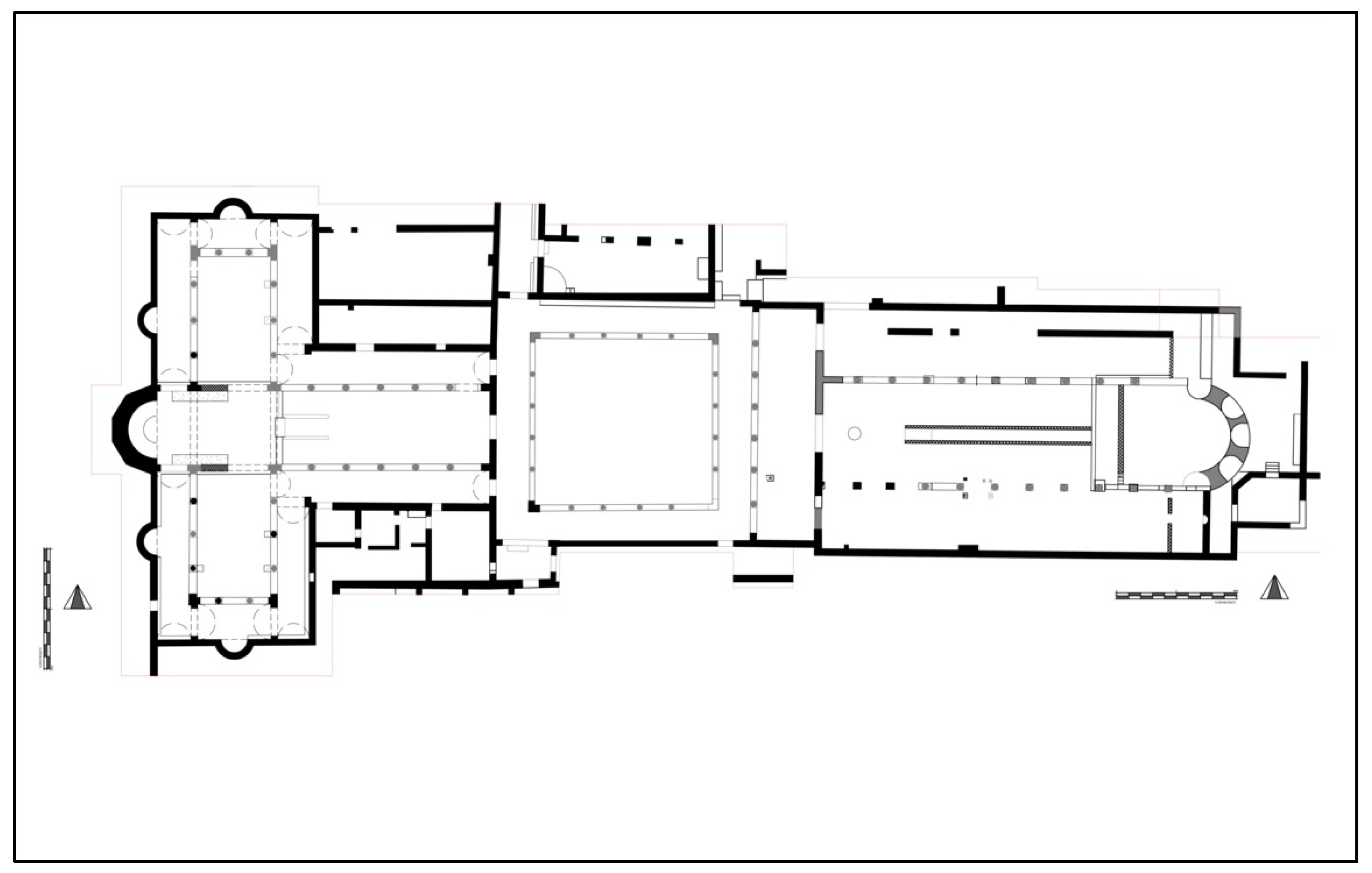
A similar processional route is visible in the early 7th century basilica at Akrotiri-Katalymmata ton Plakoton, the architecture of which imitates that of Abu Mena in Egypt (Figure 5) (Procopiou 2014, p. 83). Pilgrims would access the burials via the ambulatory colonnades. The interior colonnades separate the central aisle and bema from the transept, which was supplemented with martyr burials on five of the six walls. In a liturgical celebration, the gifts could be processed from the diakonikon, past the reliquaries and burials, before being brought to the bema. The site was built after 617 CE (according to a coin found under the martyrium walls) and abandoned around 641 CE or later (Procopiou 2014, p. 76). The basilica has been attributed to the activity of John the Almsgiver, whose return from Egypt in the early 7th century was connected to the introduction of refugees fleeing the Persian invasions in the Levant and Egypt. Burials in the western church may have included the remains of the apostle James and the protomartyr Stephen, which John is said to have saved from the oncoming sieges (Stewart 2018, p. 143). A cave inscription west of the Kourion cliffs names two Beirut men, Sergios and Nektavos, who have been interpreted as refugees as well (Procopiou 2018, pp. 91–93). The arrival of refugees may have contributed to the increase in demographic and economic activity, which in turn is visible through the patterns of church-building.
Connections between Cyprus and Egypt were already established through ceramic studies of Late Roman amphorae and maritime routes, but additional information stems from hagiographic texts. The popularity of Egypt among Cypriot pilgrims, particularly in the 7th century, centred around the shrines of Kyros, John, and Menas (Papacostas 2001, p. 113 (citing Festugière 1974, pp. 345, 362, 409)). Cypriots also frequented the shrine of Thekla near Seleucia in Cilicia (Papacostas 2001, p. 114; Vryonis 1981, p. 200). The pilgrimage routes between Egypt, Palestine, and southern Anatolia certainly interacted with those from every side of Cyprus, including Geronisos, Agios Tychonas, and Salamis. Textual sources (Papacostas 2001) and ceramic studies (Armstrong 2009) testify to the connectivity of Cyprus and pilgrimage routes. The presence and movement of pilgrims throughout the area contributed to creating and maintaining sacred topographies amidst the mercantile activity of the Cypriot coasts.
3.5.4. Construction and Church Architecture
It is worth noting the administrative role of the church and clergy over construction activity, a phenomenon which has so far been traced in workshops of liturgical furnishings and mosaics (Nicolaou 2013, p. 170; Michaelides 2020). In Bowden’s study of late antique Epirus, he proposes that the construction of churches resulted from a combination of donations from bishops or the community and free labour, but that the churches themselves still provided “testimony to the rise of a new elite in late antique society” (Bowden 2001, pp. 57–68). The influence of an individual over the architecture of early basilicas in Cyprus has been suggested for Agios Spyridon in Trimithous, Agios Epifanios in Salamis, and Akrotiri-Katalymmata ton Plakoton. The mosaic inscription at Trimithous names a Karterios as the mosaicist decorating the church under the direction of Spyridon, although this is a tenuous connection (Deligiannakis 2018, p. 345; Nicolaou 2001, p. 14; Efthymiadis 2018, p. 109).
In Maguire’s analysis, he traces Epifanios’ historical movements leading to the construction of the seven-aisled basilica in Salamis (Maguire 2012, pp. 63–96). He notes stylistic outliers, such as the transverse misalignment of the columns and supports, by comparison to other eastern Mediterranean churches where Epifanios had travelled or lived. The Salamis basilica’s similar proportions and scale to that of Mt. Sion in Jerusalem leads Maguire to suggest that the bishop strongly influenced the architectural design of his basilica.
Just as Epifanios directed the architecture of his eponymous basilica two centuries prior, John the Almsgiver relocated from Alexandria to Amathous and likely influenced Katalymmata ton Plakoton’s imitation of Abu Mena. The basilica of Abu Mena is Justinianic and existed for decades before John’s departure for Cyprus. Another potential indication of the Alexandrian martyrion is an inscription at Katalymmata: a marble table with the names of Paul and Menas (Procopiou 2015, p. 197). John’s connection to Niketas, the cousin of Heraclius, explains the presence of the Heraclius stele, which was designed in a style reminiscent of Alexander the Great. The art historical analysis of the stele provided by Stewart (2018) delves into the iconographic and literary contexts into which it may have fit, but also questions its placement in the second story of the martyrium’s gatehouse. This choice of iconography is noteworthy as a decision of the patriarch who was already commanding the architectural style of the entire complex.
The roles of clergy and bishops as influential over new basilica’s architecture can be traced at least through John the Almsgiver and Epifanios of Salamis, by creating sacred landscapes through the emulation of other churches. Numerous basilicas which were established in the late 6th century or early 7th century demonstrate a new level of activity in Cyprus, and the construction of many basilicas at that time indicate a highly organised and wealthy administration of the Christian community (for example, Kophinou, Panagia tou Kampou in Chirokitia, Pyla-Koutsopetria, Kalavasos-Kopetra, and Alassa-Agia Mavri (Procopiou 2015, p. 212)).
4. Sacred Landscapes of Copper Mining
The copper mining landscapes of Cyprus in this period can contextualise the coastal topographies within the hinterland and peripheral regions. Within the mining landscape, visibility and monumentality played a large role for ecclesiastical buildings of both Christian slaves or farming communities providing sustenance for miners, but in particular for the administrative centres such as Polis/Arsinoe, Soloi, and Nea Paphos. The mining environments with supervisory or overseer control of natural outlooks over the mines and routes include Kalavasos-Kopetra, Agia Marina-Agios Kyriakos, and Mitsero-Panagia Lambadiotissa, all of which bear strong evidence for church foundations (Rautman 2003; Given et al. 2013b, vol. II, p. 187; MKE 10, p. 364; Given and Knapp 2003, pp. 187–90; Kyriakou 2019, p. 57).
This conflation of jurisdiction and religious belief is paralleled with the churches of harbours, ports, or warehouses, but in that case, there is also the theme of visibility to the public and divine protection over the harbour. While divine protection can be part of the churches at mines, especially in light of the Christian slaves condemned to them, the quality of the churches varies considerably and brings a new question forward (Figure 6). In the southwestern Troodos and Soloi’s hinterland, roof tiles and orientation of buildings lead to conclusions of their ecclesiastical nature. By contrast, churches such as Skouriotissa, Mitsero-Panagia Lambadiotissa, and Agia Moni/Hieron show evidence of marble decorations or multiple phases of high-quality masonry and paintwork (Bakirtzis and Papageorghiou 2018). Kalavasos-Kopetra, though made with local gypsum, imitates the Christian architecture and decoration of churches in larger urban centres, and thereby brings a similar monumentality to the rural industrial landscape.
The identities created and confirmed in these deliberate architectural choices reflect not only wealth but tie the essential role of the churches to the suburban and rural environments. As ecclesiastical monuments are the most visible manifestation of Christianity in a topography, their very construction embeds the spirituality of the community into the landscape. From the Iron Age kingdoms and their competition over mining resources and settings of boundaries, through to the Hellenistic and Roman legalities concerning the administration of copper working, a diachronic view shows the centrality of the industry to sacred landscapes. Whether the cult sites are Archaic-Classical polytheistic temples, or Late Roman monotheistic churches, viewers were reminded of sanctity and identity. Studies of the Iron Age have noted the importance of rivers and ore deposit areas as relevant factors around which the political spaces and territories were conceived (Papantoniou and Kyriakou 2018). Through earthquake damage and subsequent renovation in the main cities, the establishment of new Christian monuments replaced pagan temples as focal points of the population.
In the pillow lava regions, at the mines themselves, the basilicas were small, one-aisled, and sometimes decorated with marble, for example, Panagia Skouriotissa or Mitsero-Panagia Lambadiotissa. In the administrative centres like Kalavasos, Soloi, or Polis, they were three-aisled, larger and at the centre of everyday life, performing liturgical and civic roles in their local immediate environs as well as the participation in mining control. In addition to communal faith, political power, settlement control, and function were all tied to this Christian landscape. As Caraher notes, churches are “seen as the projection of episcopal authority rather than the producers of it… [and]… represent both a medium for Christianisation and modes of its expression” (Caraher 2003, p. 58).
Within a micro-region, churches can act as the central socio-economic meeting place and religious authority. The sight of these monuments imposes a social memory on the community and newcomers, more so with multiple churches. At those with supervision roles, the viewers of such a presence are the miners, farmers, and families. In Naxos, multiple churches encircle a valley at the heights of the ridges and in the settlement at the valley floor, thereby creating a network of basilicas (Vionis 2019, p. 78). This interconnectedness not only distinguishes the micro-region as Christian but also creates a conceptual boundary between the community and the outside world. Combining the natural topographical features of mountains, rivers, coastlines, caves, etc. with Christianity results in agrarian, social, religious, and personal aspects uniting under a new distinct identity. In this sense, territory markers can redefine the nature of the territory and its borders.
At numerous copper export routes, a sense of Christian control and visibility was established by the presence of the churches, and these patterns were clearly emerging in Late Antiquity. Compared to the divine protection over ports and harbours, the church’s visibility at the mines and metal workshops is notably lesser in terms of monumentality and quality (perhaps due to less elite involvement in the mines), yet still maintains a strong conceptual identity throughout the landscape.
5. Conclusions
For Cyprus, an island with a high percentage of coastal sites, the situating of monuments at harbours and coastlines is an obvious and deliberate strategy. Centrality and access to an urban congregation provided the clergy the resources needed for its administrative participation, and vice versa for the community’s various needs. Alongside aspects like communal threshing floors or ovens, Cypriot churches also behaved as a hub for markets, a rural monument around which agrarian groups could define a community, and visible markers of Christianity in seaside towns. The ubiquity of multiple churches in sites like Amathous and Nea Paphos is imitated on smaller scales in places like Pegeia and Kalavasos.
The appearance of these churches at mines, farms, transportation routes, miner’s settlements, urban centres, and ports must have instilled a sense of supervision and protection over the extraction, processing, storage, and trade of these goods, in addition to protection of the individuals themselves. A narrative begins to emerge at the churches individually about their roles in the micro-region and the dynamic interactions of late antique sites in Cyprus with the maritime networks to the broader Mediterranean. Themes of regional distribution, pilgrimage accommodation, post-destruction occupation, and copper mining are major components at these basilicas. The centrality of economic activity at the churches and as a factor in deciding the construction of a church within a landscape deserves more focus within the “archaeology of power” conceptual framework.
This article has outlined various forms of distribution and administration by the placement of churches within coastal and rural communities in order to underline the advantages of integrating economic aspects into archaeological investigations of insular communities. The complex roles of the church are demonstrated by illuminating their active participation in sanctity and industry from many angles and on different scales. These examples highlight the economic participation of the church, whether in the planned inclusion of workshops in a church complex’s original design, or later additions of facilities to an atrium. The variety of combinations of pragmatism and monumentality contribute to discussions of third spaces and peripheral contexts, not only in complicating the binary perspectives of urban or rural, ecclesiastical, or administrative, etc., but in ongoing scholarship of sacred landscapes and insular archaeology. Socioeconomic aspects of Late Antique maritime settlements are significant in contextualising the construction of religious identity.
In the coastal and copper mining landscapes, the foundation of churches in existing industrial contexts is meaningful, projecting a Christian identity and serving as a sacred centre for the community. The visibility and connectivity of these churches range from large episcopal complexes at the port to small one-aisle chapels within the Troodos foothills, and provide ample material through which to study archaeologies of power and reflections of communal belief. The impact of the changing environment on the Late Antique individual or community, but also their influence through transitional and innovative urban developments, builds a new understanding of dynamic insular settings.
Funding
This research received no external funding.
Institutional Review Board Statement
Not applicable.
Informed Consent Statement
Not applicable.
Data Availability Statement
Not applicable.
Acknowledgments
The Department of Antiquities of Cyprus showed enormous generosity in permitting my access not only to closed sites, field notes, and photographic archives, but to the complete material of two basilicas. I would also like to thank my doctoral advisors for their supervision.
Conflicts of Interest
The author declares no conflict of interest.
Abbreviations
| AR | Archaeological Reports in JHS |
| ARDAC | Annual Report of the Department of Antiquities of Cyprus |
| MKE | Megali Kypriaki Enkyklopaidia |
References
- Ancient World Mapping Center. “Roads”. n.d. Available online: https://awmc.unc.edu/wordpress/map-files// (accessed on 9 November 2021).
- Angold, Michael, and Michael Whitby. 2008. The Church: Structures and administration. In The Oxford Handbook of Byzantine Studies. Edited by Elizabeth Jeffreys, John Haldon and Robin Cormack. Oxford: Oxford University Press, pp. 571–82. [Google Scholar]
- Milani, Celestina. 1977. Itinerarium Antonini Placentini, Un viaggio in Terra Santa del 560–70 d.C. (Itinerarium Antonini Placentini, A Journey to the Holy Land in 560–70 CE). Milan: Vita e Pensiero. [Google Scholar]
- Argoud, Gilbert, Olivier Callot, Bruno Helly, and Anne-Marie Larribeau. 1975. Le Temple de Zeus Salamine. Report of the Department of Antiquities, Cyprus. Nicosia: Department of Antiquities, Cyprus, pp. 122–41. [Google Scholar]
- Argoud, Gilbert, Olivier Callot, and Bruno Helly. 1980. Salamine de Chypre XI: Une Résidence Byzantine “L’Huilerie”. Paris: De Boccard. [Google Scholar]
- Armstrong, Pamela. 2009. Trade in the east Mediterranean in the 8th century. In Byzantine Trade, 4th–12th Centuries: The Archaeology of Local, Regional and International Exchange: Papers of the Thirty-eighth Spring Symposium of Byzantine Studies, St. John’s College, University of Oxford, March 2004. Edited by Marlia Mundell Mango. London: Routledge, pp. 157–78. [Google Scholar]
- Aupert, Pierre. 1996. Guide d’Amathonte. Paris: De Boccard. [Google Scholar]
- Bakirtzis, Charalambos. 1995. The Role of Cyprus in the Grain Supply of Constantinople in the Early Christian Period. In Cyprus and the Sea: Proceedings of the International Symposium, Nicosia, 25–26 September 1993. Edited by Vassos Karageorghis and Demetrios Michaelides. Nicosia: University of Cyprus, pp. 247–53. [Google Scholar]
- Bakirtzis, Charalambos. 1996. Description and metrology of some clay vessels from Agios Georgios, Pegeia. In The Development of the Cypriot Economy: From the Prehistoric Period to the Present Day. Edited by Vassos Karageorghis and Demetrios Michaelides. Nicosia: University of Cyprus, pp. 153–61. [Google Scholar]
- Bakirtzis, Charalambos. 2001. Aποτελέσματα ανασκαφών στον Áγιο Γεώργιο Πέγειας (Aκρωτήριον Δρέπανον), 1991–1995. In Πρακτικά του Τρίτου Διεθνούς Κυπρολογικού Συνεδρίου (Λευκωσία, 16-20 Aπριλίου 1996). Edited by Stelios A. Hadjistyllis and Georgios Ioannides. Nicosia: Society of Cypriot Studies, pp. 155–70. [Google Scholar]
- Bakirtzis, Charalambos. 2003. Archaeological Site of Agios Georgios of Peyia (Paphos). Bulletin of the European Center for Byzantine and Post-Byzantine Monuments 4: 167–241. [Google Scholar]
- Bakirtzis, Charalambos. 2019. Παλαιοχριστιανικές αρχαιότητες στον Άγιο Γεώργιο της Πέγειας (Δρέπανον) (Early Christian antiquities at Agios Georgios tis Pegeias). Aπόστολος Βαρνάβας 58: 9–23. [Google Scholar]
- Bakirtzis, Charalambos. 2020. Sea Routes and Cape Drepanon. Excavations at Agios Georgios tis Pegeias, Paphos, Cyprus. In From Roman to Early Christian Cyprus. Edited by Laura Nasrallah, Charalambos Bakirtzis and Annemarie Luijendijk. Tübingen: Mohr Siebeck, pp. 25–32. [Google Scholar]
- Bakirtzis, Charalambos, and Athanasios Papageorghiou. 2018. Ἡ Μονὴ τῆς Παναγίας τῆς Σκουριώτισσας. Report of the Department of Antiquities, Cyprus. Nicosia: Department of Antiquities, Cyprus, pp. 313–40. [Google Scholar]
- Bass, George F., and Frederick van Doorninck. 1982. Yassı Ada, Volume I: A Seventh-Century Byzantine Shipwreck. College Station: Texas A&M University Press. [Google Scholar]
- Berger, Albrecht. 2015. Konstantinopel und seine Häfen. In Häfen im 1. Millenium AD. Edited by Thomas Schmidts and Martin Marko Vučetić. Mainz: RGZM, pp. 77–88. [Google Scholar]
- Bintliff, John. 2012. The Complete Archaeology of Greece: From Hunter-Gatherers to the 20th Century AD. Chichester: Wiley-Blackwell. [Google Scholar]
- Bowden, William. 2001. A new urban elite? Church builders and church building in Late Antiquity. In Recent Research in Late Antique Urbanism. Edited by Luke Lavan. Leiden: Brill, pp. 57–68. [Google Scholar]
- Caraher, William. 2003. Church, Society, and the Sacred in Early Christian Greece. Ph.D. thesis, Ohio State University, Columbus, OH, USA. [Google Scholar]
- Caraher, William. 2021. Long Late Antiquity in the Chrysochou Valley. Presented at the Conference Cyprus in the Long Late Antiquity. History and archaeology between the 6th and the 8th Centuries, Oxford, UK, January 13–15. [Google Scholar]
- Caraher, William, and David K. Pettegrew. 2016. Imperial Surplus and Local Tastes: A Comparative Study of Mediterranean Connectivity and Trade. In Across the Corrupting Sea: Post-Braudelian Approaches to the Ancient Eastern Mediterranean. Edited by Cavan Concannon and Lindsey A. Mazurek. London: Routledge, pp. 165–92. [Google Scholar]
- Caraher, William, R. Scott Moore, and David K. Pettegrew. 2014. Pyla-Koutsopetria I: Archaeological Survey of an Ancient Coastal Town. American Schools of Oriental Research Archaeological Reports. Boston: The American Schools of Oriental Research, vol. 21. [Google Scholar]
- Chotzakoglou, Charalampos. 2005. H Βυζαντινή τέχνη στνη Κύπρο. In Ιστορία της Κύπρου. Edited by Theodoros Papadopoullos. Nicosia: Cultural Foundation of Archbishop Makarios III, pp. 465–787. [Google Scholar]
- Christodoulou, Demetrios. 1959. The Evolution of the Rural Land Use Pattern in Cyprus. Bude: Geographical Publications. [Google Scholar]
- Christou, Demos. 1994. Chronique des fouilles et découvertes archéologiques à Chypre en 1993 (Chronicle of archaeological excavations and discoveries in Cyprus in 1993). Bulletin de Correspondance Hellénique 118: 647–93. [Google Scholar]
- Christou, Demos. 1997. Chronique des fouilles et découvertes archéologiques à Chypre en 1996. Bulletin de Correspondance Hellénique 121: 891–933. [Google Scholar]
- Christou, Demos. 2013. Excavations at Kourion 1975–1998. Nicosia: Department of Antiquities, Cyprus. [Google Scholar]
- Chrysos, Evangelos. 1993. Cyprus in early Byzantine times. In The Sweet Land of Cyprus: Papers Given at the Twenty-Fifth Jubilee Spring Symposium of Byzantine Studies, Birmingham, March 1991. Edited by Anthony A. M. Bryer and Georgios S. Georghallides. Nicosia: Cyprus Research Centre, pp. 3–14. [Google Scholar]
- Connelly, Joan Breton. 2002. Excavations on Geronisos (1990–1997): First Report. Report of the Department of Antiquities, Cyprus. Nicosia: Department of Antiquities, Cyprus, pp. 245–68. [Google Scholar]
- Connelly, Joan Breton. 2010. Excavations on Geronisos, Third Report: The Circular Structure, East Building, and the Square Houses. Report of the Department of Antiquities, Cyprus. Nicosia: Department of Antiquities, Cyprus, pp. 295–348. [Google Scholar]
- Connelly, Joan Breton, and Andrew I. Wilson. 2002. Hellenistic and Byzantine cisterns on Geronisos Island. Report of the Department of Antiquities, Cyprus. Nicosia: Department of Antiquities, Cyprus, pp. 269–91. [Google Scholar]
- Davis, Thomas. 2012. Saint Paul on Cyprus: The Transformation of an Apostle. In Do Historical Matters Matter to Faith? A Critical Appraisal of Modern and Postmodern Approaches to Scripture. Edited by James K. Hoffmeier and Dennis R. Magary. Wheaton: Crossway, pp. 405–26. [Google Scholar]
- Decker, Michael J. 2009. Tilling the Hateful Earth: Agricultural Production and Trade in the Late Antique East. Oxford Studies in Byzantium. New York: Oxford University Press. [Google Scholar]
- Deligiannakis, Georgios. 2016. The Dodecanese and the Eastern Aegean Islands in Late Antiquity, AD 300–700. Oxford: Oxford University Press. [Google Scholar]
- Deligiannakis, Georgios. 2018. From Aphrodite(s) to Saintly Bishops in Late Antique Cyprus. In Authority and Identity in Emerging Christianities in Asia Minor and Greece. Edited by Cilliers Breytenbach and Julien M. Ogereau. Leiden: Brill, pp. 326–46. [Google Scholar]
- des Gagniers, Jean, and Tran Tam Tinh. 1985. Soloi: Dix campagnes de fouilles (1964–1974). Sainte-Foy: Presses de l’Université Laval. [Google Scholar]
- du Plat Taylor, Joan, and Arthur H. S. Megaw. 1981. Excavations at Ayios Philon, the Ancient Carpasia. Part II. The Early Christian Buildings. Report of the Department of Antiquities, Cyprus. Nicosia: Department of Antiquities, Cyprus, pp. 209–50. [Google Scholar]
- Efthymiadis, Stephanos. 2018. The Cult of Saints in Early Byzantine Cyprus as Mirrored in Church Building and Epigraphy. In Church Building in Cyprus (Fourth to Seventh Centuries). A Mirror of Intercultural Contacts in the Eastern Mediterranean. Edited by Marietta Horster, Doria Nicolaou and Sabine Rogge. Münster and New York: Waxmann, pp. 99–118. [Google Scholar]
- Empereur, Jean-Yves, ed. 2018. The Hellenistic Harbour of Amathus: Underwater Excavations, 1984–1986. Vol. 2, Artefacts Found during Excavation. Athens: École française d’Athènes. [Google Scholar]
- Empereur, Jean-Yves, and Tony Kozelj, eds. 2017. The Hellenistic Harbour of Amathus: Underwater Excavations, 1984–1986. Vol. 1: Architecture and History. Athens: École française d’Athènes. [Google Scholar]
- Fernández Delgado, Aitor, Javier Martínez Jiménez, and Carlos Tejerizo García. 2013. Old and New Elites in the Visigothic Kingdom. In Tough Times: The Archaeology of Crisis and Recovery. Edited by Elsbeth M. van der Wilt and Javier Martínez Jiménez. Oxford: Archaeopress, pp. 161–70. [Google Scholar]
- Festugière, André-Jean. 1974. Leontios of Neapolis, Vie de Syméon le Fou et Vie de Jean de Chypre (Life of Symeon the Fool and Life of John the Almsgiver). Paris: Librairie Orientaliste Paul Geuthner. [Google Scholar]
- Festugière, A.-J., ed. 1974. Vie de Syméon le Fou et Vie de Jean de Chypre (Life of Symeon the Fool and Life of John the Almsgiver.). Leontios of Neapolis, trans. Patrologia Graeca 93, col. 1623; BHG 886b-d. Paris: Meretseger Books. [Google Scholar]
- Flourentzos, Pavlos. 1996. Excavations in the Kouris Valley, II. The Basilica of Alassa. Nicosia: Department of Antiquities, Cyprus. [Google Scholar]
- Flourentzos, Pavlos. 2002. A Rare Magic Bronze Pendant from Amathous. Report of the Department of Antiquities, Cyprus. Nicosia: Department of Antiquities, Cyprus, pp. 365–67. [Google Scholar]
- Flusin, Bernard. 1992. Saint Anastase le Perse et l’histoire de la Palestine au début du VIIe siècle. Paris: Éditions du Centre national de la recherche scientifique. [Google Scholar]
- Gabrieli, Ruth Smadar, Mark P. C. Jackson, and Anthi Kaldelli. 2007. Stumbling into the darkness: Trade and life post-Roman Cyprus. In Proceedings of the 2nd International Conference on Late Roman Coarse Wares, Cooking Wares and Amphorae in the Mediterranean: Archaeology and Archaeometry. Aix-en-Provence-Marseille-Arles, 13th–16th April 2005. BAR International Series 1662. Edited by Michel Bonifay and Jean-Christophe Treglia. Oxford: BAR Publishing, pp. 791–801. [Google Scholar]
- Galavaris, George. 1970. Bread and the Liturgy. The Symbolism of Early Christian and Byzantine Bread Stamps. Madison: University of Wisconsin Press. [Google Scholar]
- Georgiou, George. 2013. An Early Christian baptistery on the south coast of Cyprus. Cahiers du Centre d’Etudes Chypriotes 43: 117–26. [Google Scholar] [CrossRef]
- Gerolymatou, Maria. 2008. Aγορές, έμποροι και εμπόριο στο Βυζάντιο (9ος-12ος αι.). Athens: Εθνικό Ιδρυμα Ερευνών, Ινστιτούτο Βυζαντινών Ερευνών. [Google Scholar]
- Geronisos Island Excavation. 2018. Geronisos Island Excavation: New York University. Department of Antiquities Press Release. Available online: http://www.mcw.gov.cy/mcw/da/da.nsf/All/2EC1767270AED8F9422577AE0048AAD5?OpenDocument (accessed on 7 November 2021).
- Giudice, Filippo, Elvia Giudice, and Giada Giudice. 2017. Paphos, Garrison’s Camp. XIIa Campagna (1999) (Fogli 1-3, Tavole I-II). Report of the Department of Antiquities, Cyprus. Nicosia: Department of Antiquities, Cyprus, pp. 771–810. [Google Scholar]
- Given, Michael, A. Bernard Knapp, Jay Noller, Luke Sollars, and Vasiliki Kassianidou. 2013a. Landscape and Interaction: The Troodos Archaeological and Environmental Survey Project, Cyprus. Volume 1: Methodology, Analysis and Interpretation. Levant Supplementary Series; London: Council for British Research in the Levant. [Google Scholar]
- Given, Michael, A. Bernard Knapp, Jay Noller, Luke Sollars, and Vasiliki Kassianidou. 2013b. Landscape and Interaction: The Troodos Archaeological and Environmental Survey Project, Cyprus. Volume 2: The TAESP Landscape. Levant Supplementary Series; London: Council for British Research in the Levant. [Google Scholar]
- Given, Michael, A. Bernard Knapp, Nathan Meyer, Timothy E. Gregory, Vasiliki Kassianidou, Jay Noller, Lisa Wells, Neil Urwin, and Haddon Wright. 1999. The Sydney Cyprus Survey Project: An Interdisciplinary Investigation of Long-Term Change in the North Central Troodos, Cyprus. Journal of Field Archaeology 26: 19–39. [Google Scholar]
- Given, Michael, and A. Bernard Knapp. 2003. The Sydney Cyprus Survey Project: Social Approaches to Regional Archaeological Survey. Monumenta Archaeologica. Los Angeles: UCLA Institute of Archaeology, vol. 21. [Google Scholar]
- Given, Michael. 2018. The Materiality, Monumentality, and Biography of Copper Slag on Cyprus. In An Age of Experiment: Classical Archaeology Transformed (1976–2014). Edited by Lisa Nevett and James Whitley. Cambridge: McDonald Institute for Archaeological Research, pp. 161–76. [Google Scholar]
- Graham, Angus, Kristina Winther-Jacobsen, and Vasiliki Kassianidou. 2006. Agia Marina-Mavrovouni. Preliminary Report on the Roman Settlement and Smelting Workshop in the Central Northern Foothills of the Troodos Mountains, Cyprus. Report of the Department of Antiquities, Cyprus. Nicosia: Department of Antiquities, Cyprus, pp. 345–67. [Google Scholar]
- Hadjisavvas, Sophocles. 1992. Olive Oil Processing in Cyprus: From the Bronze Age to the Byzantine Period. Studies in Mediterranean Archaeology. Göteborg: Paul Astroms Forlag. [Google Scholar]
- Hadjisavvas, Sophocles. 1997. Agia Napa: Excavations at Makronisos and the Archaeology of the Region. Nicosia: Agia Napa Municipality and the Cyprus Department of Antiquities. [Google Scholar]
- Hadjisavvas, Sophocles. 2008. The Agia Napa Aqueduct. Nicosia: Agia Napa Municipality. [Google Scholar]
- Harpster, Matthew B. 2005. A Re-Assembly and Reconstruction of the 9th-Century AD Vessel Wrecked off the Coast of Bozburun, Turkey. Ph.D. thesis, Texas A&M University, College Station, TX, USA. [Google Scholar]
- Harvey, Alan. 1989. Economic Expansion in the Byzantine Empire, 900-1200. Cambridge: Cambridge University Press. [Google Scholar]
- Häussler, Ralph, and Gian Franco Chiai. 2020. Interpreting sacred landscapes: A cross-cultural approach. In Sacred Landscapes in Antiquity: Creation, Manipulation, Transformation. Edited by Ralph Häussler and Gian Franco Chiai. Oxford: Oxbow Books, pp. 1–13. [Google Scholar]
- Hayes, John W. 2003. Hellenistic and Roman pottery deposits from the ‘Saranda Kolones’ castle site at Paphos. The Annual of the British School at Athens 98: 447–516. [Google Scholar]
- Hayes, John W. 2007. Pottery. In Kourion: Excavations in the Episcopal Precinct. Edited by Arthur H. S. Megaw. Washington, DC: Dumbarton Oaks Research Library and Collection, pp. 435–57. [Google Scholar]
- Horden, Peregrine, and Nicholas Purcell. 2000. The Corrupting Sea: A Study of Mediterranean History. Oxford: Blackwell. [Google Scholar]
- Jacobs, Ine. 2012. The Creation of the Late Antique City: Constantinople and Asia Minor during the ‘Theodosian Renaissance’. Byzantion 82: 113–64. [Google Scholar]
- Jacobs, Ine. 2013. Aesthetic Maintenance of Civic Space: The ‘Classical’ City from the 4th to the 7th c. AD. Leuven: Peeters Publishers. [Google Scholar]
- James, Simon, and Vicki Score. 2016. Ancient Akrotiri Project: Dreamer’s Bay Excavation & Survey, September 2016. Interim Report. Available online: https://www2.le.ac.uk/departments/archaeology/research/projects/ancient-akrotiri/ (accessed on 7 November 2021).
- James, Simon, Lucy Blue, Adam Rogers, and Vicki Score. 2021. From phantom town to maritime cultural landscape and beyond: Dreamer’s Bay Roman- Byzantine ‘port’, the Akrotiri peninsula, Cyprus, and Eastern Mediterranean maritime communications. Levant 52: 337–60. [Google Scholar] [CrossRef]
- Kaldelli, Anthi. 2008. Roman Amphorae from Cyprus: Integrating Trade and Exchange in the Mediterranean. Ph.D. thesis, University of London, London, UK. [Google Scholar]
- Kaplan, Michel. 1991. Maisons impériales et fondations pieuses: Réorganisation de la fortune impériale et assistance publique de la fin du VIIIe à la fin du Xe siècle. Byzantion 61: 441–64. [Google Scholar]
- Karageorghis, Vassos. 1960. Chronique des fouilles et découvertes archéologiques à Chypre en 1959 (Chronicle of archaeological excavations and discoveries in Cyprus in 1959). Bulletin de Correspondance Hellénique 84: 242–99. [Google Scholar] [CrossRef]
- Karageorghis, Vassos. 1968. Chronique des fouilles et découvertes archéologiques à Chypre en 1967 (Chronicle of archaeological excavations and discoveries in Cyprus in 1967). Bulletin de Correspondance Hellénique 92: 261–358. [Google Scholar]
- Karageorghis, Vassos. 1969. Chroniques de fouilles et découvertes archéologiques à Chypre en 1968 (Chronicle of archaeological excavations and discoveries in Cyprus in 1968). Bulletin de Correspondance Hellénique 93: 431–569. [Google Scholar]
- Karageorghis, Vassos. 1983. Chronique des fouilles et découvertes archéologiques à Chypre en 1982 (Chronicle of archaeological excavations and discoveries in Cyprus in 1982). Bulletin de Correspondance Hellénique 107: 905–53. [Google Scholar]
- Karyda, Evi. 2016. Sailing from Coast to Coast: Cabotage on the Cypriot South Coast. In Approaching Cyprus: Proceedings of the Post-Graduate Conference of Cypriot Archaeology (PoCA) Held at the University of East Anglia, Norwich, 1st–3rd November 2013. Edited by Richard Maguire and Jane Chick. Newcastle: Cambridge Scholars Publishing, pp. 78–97. [Google Scholar]
- Kassianidou, Vasiliki. 2000. Hellenistic and Roman Mining in Cyprus. In Acts of the Third International Congress of Cypriot Studies (Πρακτικὰ τοῦ Τρίτου Διεθνοῦς Κυπρολογικοῦ Συνεδρίου (Λευκωσία, 16-20 Ἀπριλίου 1996). Edited by Georgios Ioannides and Stelios A. Hadjistyllis. Nicosia: Society of Cypriot Studies, pp. 745–56. [Google Scholar]
- Koder, Johannes. 1991. Das Eparchenbuch Leons des Weisen (Book of the Eparch). Vienna: Verlag der Österreichischen Akademie der Wissenschaften. [Google Scholar]
- Kowalzig, Barbara. 2018. Cults, Cabotage, and Connectivity: Experimenting with Religious and Economic Networks in the Greco-Roman Mediterranean. In Maritime Networks in the Ancient Mediterranean World. Edited by Justin Leidwanger and Carl Knappett. Nicosia: Astrom Editions, pp. 47–66. [Google Scholar]
- Kyriakou, Niki. 2019. The sacred landscapes of Cyprus in Late Antiquity: Cityscapes and peripheries in context. In Unlocking Sacred Landscapes: Spatial Analysis of Ritual and Cult in the Mediterranean. Edited by Giorgos Papantoniou, Christine E. Morris and Athanasios K. Vionis. Nicosia: Astrom Editions, pp. 47–66. [Google Scholar]
- Kyrris, Costas P. 1997. Cyprus, Byzantium and the Arabs from the Mid-7th to the Early 8th Century. In Oriente e Occidente fra Medioevo ed età moderna: Studi in onore di Geo Pistarino. Edited by Laura Belletto. Genoa: Brigati, pp. 668–91. [Google Scholar]
- Laiou, Angeliki E. 2002. Exchange and Trade, Seventh-Twelfth Centuries. In The Economic History of Byzantium: From the Seventh through the Fifteenth Century. Edited by Angeliki E. Laiou. Washington, DC: Dumbarton Oaks Research Library and Collection, pp. 697–770. [Google Scholar]
- Laiou, Angeliki E. 2013. Economic Thought and Economic Life in Byzantium. Farnham: Routledge. [Google Scholar]
- Leidwanger, Justin. 2013. Opportunistic Ports and Spaces of Exchange in Late Roman Cyprus. Journal of Maritime Archaeology 8: 221–43. [Google Scholar] [CrossRef]
- Leidwanger, Justin. 2020. Roman Seas: A Maritime Archaeology of Eastern Mediterranean Economies. New York: Oxford University Press. [Google Scholar]
- Leonard, John R. 1995. The Anchorage at Kioni. In Ancient Akamas I: Settlement and environment. Edited by Jane Fejfer. Aarhus: Aarhus University Press, pp. 133–70. [Google Scholar]
- Leonard, John R. 2005. Roman Cyprus: Harbors, Hinterlands, and “Hidden Powers”. Ph.D. thesis, State University of New York at Buffalo, Buffalo, NY, USA. [Google Scholar]
- Leone, Anna. 2007. Changing Townscapes in North Africa from Late Antiquity to the Arab Conquest. Bari: Edipuglia. [Google Scholar]
- Lokin, Johannes H. A. 1986. Administration and jurisdiction in Cyprus, in the sixth century AD. In Acts of the Second International Conference on Cypriot Studies. Edited by Theodoros Papadopoulos and Benedictos Egglezakis. Nicosia: Society of Cypriot Studies, pp. 35–46. [Google Scholar]
- Lund, John. 2006. On the Circulation of Goods in Hellenistic and Early Roman Cyprus: The Ceramic Evidence. In Panayia Ematousa. Edited by Lone Wriedt Sørensen and Kristina Winther-Jacobsen. Aarhus: Aarhus University Press, pp. 31–49. [Google Scholar]
- Maguire, Richard. 2012. Late Antique Basilicas on Cyprus: Sources, Contexts, Histories. Ph.D. thesis, University of East Anglia, Norwich, UK. [Google Scholar]
- Maier, Franz Georg, and Vassos Karageorghis. 1984. Paphos. History and Archaeology. Nicosia: A. G. Leventis Foundation. [Google Scholar]
- Mailis, Athanassios. 2011. The Annexes at the Early Christian Basilicas of Greece (4th-6th c.). BAR International Series 2312; Oxford: Archaeopress. [Google Scholar]
- Manning, Sturt W., and David H. Conwell. 1992. Maroni Valley Archaeological Survey Project: Preliminary Report on the 1990–1991 Seasons. Report of the Department of Antiquities, Cyprus. Nicosia: Department of Antiquities, Cyprus, pp. 271–84. [Google Scholar]
- Manning, Sturt W., and Andrew Manning. 2002. The Late Roman Church at Maroni Petrera. Survey and Salvage Excavations 1990–1997, and Other Traces of Roman Remains in the Lower Maroni Valley, Cyprus. Nicosia: A. G. Leventis Foundation. [Google Scholar]
- Manning, Sturt W., Sarah J. Monks, David A. Sewell, and Stella Demesticha. 2000. Late Roman Type 1a Amphora Production at the Late Roman Site of Zygi-Petrini, Cyprus. Report of the Department of Antiquities, Cyprus. Nicosia: Department of Antiquities, Cyprus, pp. 233–57. [Google Scholar]
- Megaw, Arthur H. S. 1974. Byzantine architecture and decoration in Cyprus: Metropolitan or provincial? Dumbarton Oaks Papers 28: 59–88. [Google Scholar] [CrossRef]
- Megaw, Arthur H. S. 1988. Reflections on Byzantine Paphos. In Kathegetria: Essays Presented to Joan Hussay. Edited by Julian Chrysostomides. Camberley: Porphyrogenitus, pp. 135–50. [Google Scholar]
- Megaw, Arthur H. S. 2006. The Campanopetra reconsidered: The pilgrimage church of the Apostle Barnabas? In Byzantine Style, Religion and Civilization. In Honour of Sir Steven Runciman. Edited by Elizabeth Jeffreys. Cambridge: Cambridge University Press, pp. 394–404. [Google Scholar]
- Megaw, Arthur H. S. 2007. Kourion: Excavations in the Episcopal Precinct. Washington: Dumbarton Oaks Research Library and Collection. [Google Scholar]
- Metcalf, David M. 2009. Byzantine Cyprus 491-1191. Nicosia: Cyprus Research Centre. [Google Scholar]
- Michaelides, Demetrios. 2001. The Ambo of Basilica A at Cape Drepanon. In Mosaic. Festschrift for Arthur H. S. Megaw. Edited by Judith Herrin, Margaret Mullett and Catherine Otten-Froux. London: British School at Athens, pp. 43–56. [Google Scholar]
- Michaelides, Demetrios. 2014. The Significance of the Basilica at Agioi Pente of Yeroskipou. In Cyprus and the Balance of Empires: Art and Archaeology from Justinian I to the Coeur de Lion. Edited by Charles Stewart, Thomas Davis and Annemarie Weyl Carr. Boston: American Schools of Oriental Research, pp. 1–16. [Google Scholar]
- Michaelides, Demetrios. 2020. Mosaic Workshops in Cyprus from the Fourth to the Seventh Centuries CE: Two Parallel Lives? In From Roman to Early Christian Cyprus. Edited by Laura Nasrallah, Charalambos Bakirtzis and Annemarie Luijendijk. Tübingen: Mohr Siebeck, pp. 93–110. [Google Scholar]
- Michail, Rania. 2018. The Early Christian Baptismal Complexes of Cyprus and Their Liturgical Arrangement. In Church Building in Cyprus (Fourth to Seventh Centuries). A Mirror of Intercultural Contacts in the Eastern Mediterranean. Edited by Marietta Horster, Doria Nicolaou and Sabine Rogge. Münster and New York: Waxmann, pp. 153–74. [Google Scholar]
- Miszk, Łukasz, and Ewdoksia Papuci-Władyka. 2016. Nea Paphos and its harbours. Gates to the Mediterranean in the light of the Jagiellonian University research. In North Meets East 3: Aktuelle Forschungen zu antiken Häfen. Edited by Martina Seifert and Leon Ziemer. Aachen: Shaker Verlag, pp. 1–19. [Google Scholar]
- Najbjerg, Tina, Charles Nicklies, and Amy Papalexandrou. 2002. Princeton University Excavations at Polis/Arsinoe: Preliminary Report on the Roman and Medieval Levels. Report of the Department of Antiquities, Cyprus. Nicosia: Department of Antiquities, Cyprus, pp. 139–54. [Google Scholar]
- Nicolaou, Doria. 2013. Liturgical Furnishings from Early Christian Basilicas of Cyprus (4th–7th century). Cahiers du Centre d’Etudes Chypriotes 43: 155–74. [Google Scholar] [CrossRef]
- Nicolaou, Doria. 2016. Gli amboni paleocristiani ciprioti. Rivista di Archeologia Cristiana 92: 313–48. [Google Scholar]
- Nicolaou, Ino. 2001. The Transition from Paganism to Christianity as revealed in the Mosaic Inscriptions of Cyprus. In Mosaic. Festschrift for Arthur H. S. Megaw. Edited by Judith Herrin, Margaret Mullett and Catherine Otten-Froux. London: British School at Athens, pp. 13–17. [Google Scholar]
- Papacostas, Tassos. 1999. Byzantine Cyprus: The Testimony of Its Churches, 650–1200. Ph.D. thesis, University of Oxford, Oxford, UK. [Google Scholar]
- Papacostas, Tassos. 2001. The economy of Late Antique Cyprus. In Economy and Exchange in the East Mediterranean during Late Antiquity. Proceedings of a One-Day Conference at Somerville College, Oxford, 29th May 1999. Edited by Sean Kingsley and Michael Decker. Oxford: Oxbow Books, pp. 107–28. [Google Scholar]
- Papacostas, Tassos. 2013. The Troodos Mountains of Cyprus in the Byzantine Period: Archaeology, Settlement, Economy. Cahiers du Centre d’Etudes Chypriotes 43: 175–200. [Google Scholar] [CrossRef]
- Papacostas, Tassos. 2015a. Monastic estates in the middle Byzantine period: Evidence from Cyprus for local and overseas landowners. In Medieval Cyprus: A Place of Cultural Encounter. Edited by Michael Grünbart and Sabine Rogge. Münster: Waxmann, pp. 121–46. [Google Scholar]
- Papacostas, Tassos. 2015b. Neapolis—Nemesos—Limassol: From Late Antiquity to the time of the Crusades. In The Tale of a City: Lemesos/Limassol from Antiquity to ca. 1900. Edited by Angel Nicolaou-Konnari and Chris Schabel. Cambridge: Cambridge Scholars Publishing, pp. 96–188. [Google Scholar]
- Papageorghiou, Athanasios. 1969. Ἡ Παλαιοχριστιανικὴ καὶ Βυζαντινὴ Ἀρχαιολογία καὶ Τέχνη ἐν Κύπρῳ κατὰ τὰ ἔτη 1967–1968. Ἀπόστολος Βαρνάβας 30: 81–93, 145–60, 218–24, 280–90, 354–63. [Google Scholar]
- Papageorghiou, Athanasios. 1985. L’architecture paléochrétienne de Chypre. Corsi di Cultura sull’Arte Ravennate e Bizantina 32: 229–334. [Google Scholar]
- Papageorghiou, Athanasios. 1986. Foreign influences on the Early Christian architecture of Cyprus. In Acts of the International Archaeological Symposium ‘Cyprus Between the Orient and the Occident’, Nicosia, 8–14 September 1985. Edited by Vassos Karageorghis. Nicosia: Department of Antiquities, Cyprus, pp. 490–503. [Google Scholar]
- Papalexandrou, Amy. 2012. Polis/Arsinoë in Late Antiquity: A Cypriot town and its sacred sites. In Approaches to Byzantine Architecture and Its Decoration. Studies in Honor of Slobodan Ćurčić. Edited by Mark J. Johnson, Robert Ousterhout and Amy Papalexandrou. Farnham: Routledge, pp. 27–46. [Google Scholar]
- Papalexandrou, Amy, and William Caraher. 2012. Arsinoe in Late Antiquity and the Middle Ages. In City of Gold. The Archaeology of Polis Chrysochous, Cyprus. Edited by William A. P. Childs, Joanna S. Smith and J. Michael Padgett. New Haven: Princeton University Art Museum, pp. 266–82. [Google Scholar]
- Papantoniou, Giorgos. 2013. Cyprus from Basileis to Strategos: A Sacred-Landscapes Approach. American Journal of Archaeology 117: 33–57. [Google Scholar] [CrossRef]
- Papantoniou, Giorgos, and Athanasios K. Vionis. 2018. The River as an Economic Asset: Settlement and Society in the Xeros Valley in Cyprus. Land 7: 157. [Google Scholar] [CrossRef] [Green Version]
- Papantoniou, Giorgos, and Niki Kyriakou. 2018. Revisiting Cypriot Sacred Landscapes: A Regional GIS Approach. American Journal of Archaeology 122: 541–77. [Google Scholar] [CrossRef]
- Papuci-Władyka, Ewdoksia, Wojciech Machowski, and Łukasz Miszk. 2018. ‘Paphos Agora Project’ (PAP) 2011–2014: First Preliminary Report on Excavations by the Jagiellonian University in Kraków, Poland. Report of the Department of Antiquities, Cyprus New Series 1; Nicosia: Department of Antiquities, Cyprus, pp. 533–66. [Google Scholar]
- Parani, Maria. 2013. Artisanal Production in Late Antique Cyprus. In The Insular System of the Early Byzantine Mediterranean. Archaeology and History. Edited by Demetrios Michaelides, Philippe Pergola and Enrico Zanini. Oxford: Archaeopress, pp. 131–38. [Google Scholar]
- Preiser-Kapeller, Johannes, and Falko Daim, eds. 2015. Harbours and Maritime Networks as Complex Adaptive Systems. Mainz: Verlag des Römisch-Germanischen Zentralmuseums. [Google Scholar]
- Prête, Jean-Paul. 2007. Topographie due centre monumental d’Amathonte à l’époque hellénistique. In From Evagoras I to the Ptolemies: The Transition from the Classical to the Hellenistic Period in Cyprus. Edited by Pavlos Flourentzos. Nicosia: Department of Antiquities, Cyprus, pp. 115–29. [Google Scholar]
- Procopiou, Eleni. 1996. Basilique Paléochrétienne. Bulletin de Correspondance Hellénique 120: 1069. [Google Scholar]
- Procopiou, Eleni. 2006. Τα μνημεία της πόλης και Επαρχίας Λεμεσού κατά την παλαιοχριστιανική, πρωτοβυζαντινή και μεσοβυζαντινή περίοδο 324-1191. In Λεμεσός: Ταξίδι στους χρόνους μιας πόλης. Edited by Άννα Μαραγγού. Limassol: House of Cyprus and Cyprological Publications, pp. 113–28. [Google Scholar]
- Procopiou, Eleni. 2013. L’architecture chrétienne dans la région d’Amathonte à l’époque byzantine (IVe-XIIe siècles). Cahiers du Centre d’Études Chypriotes 43: 253–74. [Google Scholar] [CrossRef]
- Procopiou, Eleni. 2014. The Katalymmata ton Plakoton: New Light from the Recent Archaeological Research. In Cyprus and the Balance of Empires: Art and Archaeology from Justinian I to the Coeur de Lion. Edited by Charles Stewart, Thomas Davis and Annemarie Weyl Carr. Boston: American Schools of Oriental Research, pp. 69–98. [Google Scholar]
- Procopiou, Eleni. 2015. The Excavations at Akrotiri-Katalymata ton Plakoton. In Medieval Cyprus: A Place of Cultural Encounter. Edited by Sabine Rogge and Michael Grünbart. Münster: Waxmann Verlag, pp. 185–218. [Google Scholar]
- Procopiou, Eleni. 2018. New Evidence for the Early Byzantine Ecclesiastical Architecture of Cyprus. In Church Building in Cyprus (Fourth to Seventh Centuries). A Mirror of Intercultural Contacts in the Eastern Mediterranean. Edited by Marietta Horster, Doria Nicolaou and Sabine Rogge. Münster and New York: Waxmann, pp. 73–98. [Google Scholar]
- Raber, Paul. 1987. Early copper production in the Polis region, western Cyprus. Journal of Field Archaeology 14: 297–312. [Google Scholar]
- Randall, Ian. 2013. Continuity and Change in the Ceramic Data: “The Byzantine Problem” and Cyprus during the Treaty Centuries. Cahiers du Centre d’Etudes Chypriotes 43: 275–86. [Google Scholar] [CrossRef]
- Rapp, Claudia. 2005. Holy Bishops in Late Antiquity: The Nature of Christian Leadership in an Age of Transition. Berkeley: University of California Press. [Google Scholar]
- Raptis, Konstantinos, and Styliani Vassiliadou. 2005. Διαχρονική χρήση, διαδοχικές θέσεις και απόπειρα επανένταξης των μαρμάρινων αρχιτεκτονικών μελών των βασιλικών A, Β, Γ Aγίου Γεωργίου Πέγειας (Πάφος): από την παραγωγή στα παλαιοχριστιανικά λατομεία της πρωτεύουσας στην διαμόρφωση του αρχαιολογικού χώρου. Report of the Department of Antiquities, Cyprus. Nicosia: Department of Antiquities, Cyprus, pp. 199–224. [Google Scholar]
- Rautman, Marcus. 2000. The Busy Countryside of Late Roman Cyprus. Report of the Department of Antiquities, Cyprus. Nicosia: Department of Antiquities, Cyprus, pp. 317–31. [Google Scholar]
- Rautman, Marcus. 2003. A Cypriot Village of Late Antiquity: Kalavasos-Kopetra in the Vasilikos Valley. Supplementary Series 52; Portsmouth: Journal of Roman Archaeology. [Google Scholar]
- Rautman, Marcus. 2014. The Troodos in Twilight: A Provincial Landscape in the Time of Justinians. In Cyprus and the Balance of Empires: Art and Archaeology from Justinian I to the Coeur de Lion. Edited by Charles Stewart, Thomas Davis and Annemarie Weyl Carr. Boston: American Schools of Oriental Research, pp. 39–56. [Google Scholar]
- Rautman, Marcus, and Murray McClellan. 1990. The 1989 Field Season at Kalavasos-Kopetra. Report of the Department of Antiquities, Cyprus. Nicosia: Department of Antiquities, Cyprus, pp. 231–38. [Google Scholar]
- Roux, Georges. 1998. La basilique de la Campanopétra. Salamine de Chypre. Vol. XV. Paris: Mission Archéologique Française de Salamine de Chypre. [Google Scholar]
- Saradi, Helen. 2006. The Byzantine City in the Sixth Century: Literary Images and Historical Reality. Athens: Society of Messenian Archaeological Studies. [Google Scholar]
- Schoell, Rudolf, and Wilhelm Kroll. 2014. Corpus Iuris Civilis, Vol. 3: Novellae. Cambridge: Cambridge University Press. [Google Scholar]
- Sørensen, Lone Wriedt, and Kristina Winther-Jacobsen, eds. 2006. Panayia Ematousa. Aarhus: Aarhus University Press. [Google Scholar]
- Stewart, Charles. 2008. Domes of Heaven: The Domed Basilicas of Cyprus. Ph.D. thesis, Indiana University, Bloomington, IN, USA. [Google Scholar]
- Stewart, Charles. 2018. A Byzantine Image of Alexander: Literature Manifested in Stone. Report of the Department of Antiquities, Cyprus. Nicosia: Department of Antiquities, Cyprus, pp. 141–201. [Google Scholar]
- Todd, Ian A. 2004. Vasilikos Valley Project 9: The Field Survey of the Vasilikos Valley. Studies in Mediterranean Archaeology: Vol. LXXI. Uppsala: Astroms Vorlag. [Google Scholar]
- Trombley, Frank R. 1987. Korykos in Cilicia Trachis: The Economy of a Small Coastal City in Late Antiquity (Saec. V-VI)—A Precis. The Ancient History Bulletin 1: 16–23. [Google Scholar]
- Van den Ven, Paul. 1953. La légende de S. Spyridon, évêque de Trimithonte. Leuven: Publications Universitaires. [Google Scholar]
- Veikou, Myrto. 2009. “Rural Towns” and “In-Between” or “Third” Spaces. Settlement Patterns in Byzantine Epirus (7th-11th c.) from an interdisciplinary approach. Archeologia Medievale 36: 43–54. [Google Scholar]
- Veikou, Myrto. 2015. Mediterranean Byzantine Ports and Harbours in the Complex Interplay between Environment and Society. Spatial, Socio-Economic and Cultural Considerations Based on Archaeological Evidence from Greece, Cyprus and Asia Minor. In Harbours and Maritime Networks as Complex Adaptive Systems. International Workshop “Harbours and maritime Networks as Complex Adaptive Systems” at the Römisch-Germanisches Zentralmuseum in Mainz, 17.-18.10.2013, within the framework of the Special Research Programme (DFG-SPP 1630) “Harbours from the Roman Period to the Middle Ages”. Edited by Johannes Preiser-Kapeller and Falko Daim. Mainz: Verlag des Römisch-Germanischen Zentralmuseums, pp. 39–60. [Google Scholar]
- Vionis, Athanasios K. 2017. Sacred Townscapes in Late Antique Greece: Christianisation and Economic Diversity in the Aegean. Journal of Mediterranean Archaeology 30: 141–65. [Google Scholar] [CrossRef]
- Vionis, Athanasios K. 2019. The spatiality of the Byzantine/Medieval rural church: Landscape parallels from the Aegean and Cyprus. In Unlocking Sacred Landscapes: Spatial Analysis of Ritual and Cult in the Mediterranean. Edited by Giorgos Papantoniou, Christine E. Morris and Athanasios K. Vionis. Nicosia: Astrom Editions, pp. 67–84. [Google Scholar]
- Vionis, Athanasios K., and Giorgos Papantoniou. 2017. Sacred Landscapes as Economic Central Places in Late Antique Naxos and Cyprus. Antiquité Tardive 25: 263–86. [Google Scholar] [CrossRef]
- von Falkenhausen, Vera. 1999. Bishops and Monks in the Hagiography of Cyprus. In Medieval Cyprus: Studies in Art, Architecture, and History in Memory of Doula Mouriki. Edited by Nancy Patterson Ševčenko and Christopher Moss. Princeton: Princeton University Press, pp. 21–33. [Google Scholar]
- Vryonis, Speros. 1981. The panegyris of the Byzantine saint. In The Byzantine Saint. Edited by Sergei Hackel. Crestwood: St Vladimir’s Seminary Press, pp. 196–226. [Google Scholar]
- Wickham, Christopher. 2005. Framing the Early Middle Ages: Europe and the Mediterranean 400-800. Oxford: Oxford University Press. [Google Scholar]
- Wilkinson, John. 1977. Jerusalem Pilgrims before the Crusades. Warminster: Aris & Philips. [Google Scholar]
- Winther-Jacobsen, Kristina. 2006. Utility Wares. In Panayia Ematousa. Edited by Lone Wriedt Sørensen and Kristina Winther-Jacobsen. Aarhus: Aarhus University Press, pp. 244–302. [Google Scholar]
- Winther-Jacobsen, Kristina. 2010. From Pots to People: A Ceramic Approach to the Archaeological Interpretation of Ploughsoil Assemblages in Late Roman Cyprus. Leuven: Peeters. [Google Scholar]
- Zavagno, Luca. 2017. Cyprus between the Late Antiquity and the Early Middle Ages (ca. 600-800): An Island in Transition. London: Routledge. [Google Scholar]
Figure 1.
Map of Cyprus and late Roman road network (Adapted from Ancient World Mapping Center, and Dig-TIB, ÖAW).
Figure 1.
Map of Cyprus and late Roman road network (Adapted from Ancient World Mapping Center, and Dig-TIB, ÖAW).

Figure 2.
Late Antique sites on the Akrotiri peninsula. 1: Agia Iphigenia; 2: Kato Katalymmata; 3: Pano Katalymmata; 4: Shillastasia; 5: Arkosykia; 6: Agios Markos; 7: Agios Sylas cave; 8: Dreamer’s Bay; 9: Lania cave basilicas, 10: Katalymmata ton Plakoton (Adapted from James et al. 2021, p. 19).
Figure 2.
Late Antique sites on the Akrotiri peninsula. 1: Agia Iphigenia; 2: Kato Katalymmata; 3: Pano Katalymmata; 4: Shillastasia; 5: Arkosykia; 6: Agios Markos; 7: Agios Sylas cave; 8: Dreamer’s Bay; 9: Lania cave basilicas, 10: Katalymmata ton Plakoton (Adapted from James et al. 2021, p. 19).

Figure 3.
Plan of Panagia Chrysopolitissa and view south of the residence (Plan courtesy of the Department of Antiquities Cyprus, Photo: C. Keane).
Figure 3.
Plan of Panagia Chrysopolitissa and view south of the residence (Plan courtesy of the Department of Antiquities Cyprus, Photo: C. Keane).

Figure 4.
Plan of Agios Georgios, Pegeia (Raptis and Vassiliadou 2005, p. 200, courtesy of the Greek Archaeological Mission at Agios Georgios Pegeias).
Figure 4.
Plan of Agios Georgios, Pegeia (Raptis and Vassiliadou 2005, p. 200, courtesy of the Greek Archaeological Mission at Agios Georgios Pegeias).

Figure 5.
Katalymmata ton Plakoton basilicas (Procopiou 2018, p. 86).
Figure 5.
Katalymmata ton Plakoton basilicas (Procopiou 2018, p. 86).

Figure 6.
Map of the Troodos range with slag heaps and churches marked (Given 2018, p. 167).
Figure 6.
Map of the Troodos range with slag heaps and churches marked (Given 2018, p. 167).

Publisher’s Note: MDPI stays neutral with regard to jurisdictional claims in published maps and institutional affiliations. |
© 2021 by the author. Licensee MDPI, Basel, Switzerland. This article is an open access article distributed under the terms and conditions of the Creative Commons Attribution (CC BY) license (https://creativecommons.org/licenses/by/4.0/).
Share and Cite
MDPI and ACS Style
Keane, C.T. Ecclesiastical Economies: The Integration of Sacred and Maritime Topographies of Late Antique Cyprus. Religions 2021, 12, 989. https://0-doi-org.brum.beds.ac.uk/10.3390/rel12110989
AMA Style
Keane CT. Ecclesiastical Economies: The Integration of Sacred and Maritime Topographies of Late Antique Cyprus. Religions. 2021; 12(11):989. https://0-doi-org.brum.beds.ac.uk/10.3390/rel12110989
Chicago/Turabian StyleKeane, Catherine T. 2021. "Ecclesiastical Economies: The Integration of Sacred and Maritime Topographies of Late Antique Cyprus" Religions 12, no. 11: 989. https://0-doi-org.brum.beds.ac.uk/10.3390/rel12110989
Note that from the first issue of 2016, this journal uses article numbers instead of page numbers. See further details here.