
The Construction of Sacred Landscapes and Maritime Identities in the Post-Medieval Cyclades Islands: The Case of Paros


Archaeological Research Unit, University of Cyprus, Nicosia 1678, Cyprus
Religions 2022, 13(2), 164; https://0-doi-org.brum.beds.ac.uk/10.3390/rel13020164
Submission received: 30 December 2021
/
Revised: 31 January 2022
/
Accepted: 8 February 2022
/
Published: 14 February 2022
(This article belongs to the Special Issue Unlocking Sacred Landscapes: Religious and Insular Identities in Context)
Abstract
:The Cyclades islands in the South Aegean initially attracted the attention of prehistorians approaching islands as ‘laboratories’ for the study of cultural development, examining the notions of ‘isolation’ and ‘connectivity’, or, more recently, by introducing new terminologies, such as ‘seascape’ and ‘islandscape’. The wealth of material remains of the post-medieval era in the Cyclades islands (e.g., ecclesiastical architecture, ceramics) and the textual record available (e.g., Ottoman tax registers, travellers’ accounts) provide fascinating evidence regarding the construction of sacred landscapes, self-expression, community, and maritime identities throughout the period of Ottoman domination. The main aim of this article is to examine the historical contingencies and the distribution of a vast number of rural churches, primarily as evidence for religious expression, in order to capture island dynamics and the formation of religious and community identities, as imprinted onto the sacred landscapes of the island of Paros. By shifting our focus from the imperial Ottoman to the local Cycladic, we come to appreciate islanders as decisive agents of their maritime identities, creating rituals and sacred spaces, sometimes beyond the strict borders of institutional religion.
1. Introduction
The concept and historical reality of isolation, connectivity, identities, and ‘island archaeologies’ in the Cyclades have been discussed in the framework of studies dealing with the prehistoric past, the Classical Greek and Byzantine eras, and the period of Ottoman domination. The Mediterranean region, whether fragmented by the sea, creating a network of ‘true islands’ defined as landmasses surrounded by water, or comprising ‘isolated patches’ of terrestrial habitat defined as ‘islands that the sea does not surround’ (Braudel 1972, pp. 149–51, 160–61; Whittaker 1998, p. 7), has been examined both as an area of isolation and exoticism and as a highway of travel and connectivity (Boomert and Bright 2007, pp. 4–9). Respectively, the position of the ‘Greek Archipelago’ (the Aegean Sea) between isolation and communication networks, without a centre of its own, as Spyros Asdrachas (1985, p. 236; 2018, p. 4) has noted, demonstrates not only cultural diversity between islands of different sizes (Renfrew and Wagstaff 1982, pp. 1–3), but also that the identity of island communities was never static (Gordon 2018, p. 10).
Inspired by evolutionary biology and island biogeography, which emphasised that islands are isolated habitats with a high degree of floral and faunal endemism, archaeologists, exploring past island communities in the Mediterranean and the Aegean, viewed islands as ‘laboratories’ for the study of cultural evolution and colonisation by humans (Evans 1973; Cherry 1981; Rainbird 2007; cf. Boomert and Bright 2007, pp. 5–9; DiNapoli and Leppard 2018, p. 157). The appreciation of the sea as a means of connection and communication, and the understanding of insularity as a constantly changing element, came as a reaction to previous ‘insular’ approaches to islands, with specialists proposing the term ‘islandscape’ to grasp the diverse behaviour of island communities in the prehistoric Aegean (Broodbank 2000, pp. 17–22; Cherry and Leppard 2015, p. 18). Meanwhile, the concept of ‘agency’ (with local people as active agents in island life) and historical and social contingencies have also played a role in the exploration of insularity in both prehistory and historical times, on both small and larger islands, from the Caribbean to the eastern Mediterranean (Lape 2004; Knapp 2008; Papantoniou 2012, 2013; cf. Gordon 2018, p. 9). In this framework, it is important that we stress the diversity that characterises islands and the need for plurality in our interpretative approaches (Broodbank 2000, p. 7; Papantoniou 2012, p. 47).
Recognising the multiple facets of insularity in the Aegean Sea in later centuries, with a special focus on the Classical Greek and Byzantine periods in the Cyclades, it has become clear that the islands acted both as ‘closed’ and as ‘open’ and interacting entities, as attested in the literary sources and the archaeological record (Constantakopoulou 2007, pp. 2–3; Vionis 2017, pp. 167–69). In the context of the ancient Athenian Empire and its domination over the Aegean, Christy Constantakopoulou (2007, pp. 119–20) has argued that islands could also be perceived as territories of ‘safety’, away from the centre and the oppression of empires. One can observe a similar situation in Byzantine times, when islands functioned both as places of exile and remoteness (Malamut 1988, p. 175) and as a ‘zone of interaction’ between antagonistic powers, e.g., the Byzantines and the Arabs (Constantakopoulou 2007, p. 133; Vionis 2017, p. 168; Vionis and Papantoniou 2019, p. 277).
Reference to the Aegean Sea in the Ottoman period as ‘Adalar Denizi’, or ‘Sea of Islands’ (Constantakopoulou 2007, p. 1), implies the active role of islands, such as the Cyclades, in the maritime networks of communication. This interaction between islanders and the ‘outside world’ comprises a constant reminder of our need to always consider the role that the sea (Vogiatzakis et al. 2017) and the special natural and/or anthropogenic features of each island (Rackham 2012) played in shaping their particularity, individuality and distinct communal/group identity (cf. Vionis and Papantoniou 2019, pp. 258–59). Previous individual scholars and specialised collective volumes have already paid attention to the aforementioned issues. Some have underlined that insularity in the Ottoman Empire did not equal isolation (cf. Vatin and Veinstein 2004), others that internal and external impositions are equally important factors (cf. Hadjikyriacou 2018), or that local agents contributed to the formation of island identities in a period when islands did not comprise ‘strategic’ naval entities (cf. Imber 2002; Kolovos 2006, 2007). Meanwhile, detailed information about population, settlements and production deriving from the Ottoman tax registers (tahrir defterleri) of 1570 (Kiel 2007) and 1670 (Slot 1982) provide the wellspring from which we may generate economic patterns in the Cyclades, as well as aspects related to the formation of community and religious identities (cf. Vionis 2012).
Revisiting the seminal paper on ‘Greek insularity’ by Asdrachas (1985, pp. 238–39), we may set off on our exploration of island sacred landscapes and maritime identities in the Cyclades with the observation that the islands succeeded in maintaining maritime contact between the two halves of the Mediterranean, cultivating, at the same time, their feeling of belonging (to the Ottoman Empire). What united Aegean islanders during the eras they comprised part of the Byzantine and Ottoman Empires was that they were oriented towards the ‘Hellenic-spirited’ capital of Constantinople/Istanbul (Spiridonakis 1977), no matter whether the ruler was Christian or Muslim. As the textual record affirms, since the early 17th century, the administrative division of the Aegean islands into ‘pairs’ (e.g., Paros and Naxos, Andros and Syros, etc.) inevitably strengthened the relations between islands (Asdrachas 1985, p. 239; Kolovos 2007, pp. 54–55). This fact obviously testifies to local or interregional connections, mutuality and common experiences, if nothing else. Foreign travellers in the Cyclades, from Joseph Pitton de Tournefort (1718) to James Theodore Bent (1885), also stress the individuality of the islands (in accent, dress code, etc.) on the one hand and their shared expression of religiosity and superstition on the other, when it comes to citing practices outside the borders of institutional religion.
The distribution of 36 monasteries and 310 churches in villages and the countryside of the island of Paros alone, constructed between the mid-16th and the late 18th centuries, not only implies a prominent sense of piety and Christian-Orthodox identity amongst islanders, but also attests to a general stability and economic recovery due to historical contingency (Vionis 2012, pp. 45–56). The 17th century, when church-building activity on Paros and other Cycladic islands climaxed, comprises a case to examine, not only in the context of historical contingency in the Aegean, but also in continental Europe; as David Abulafia has put it when referring to earlier historical periods, “one person’s impoverishment can be another person’s economic opportunity” (Abulafia 2019, p. 291). The centrality of the Ottoman State and the Sultan’s ‘disinterest’ in the small Aegean islands (Kolovos 2018, p. 10), the special privileges in local administration and religious expression granted to Cycladic communities by successive Sultans (Slot 1982, p. 78; Davis 1991, p. 143; Vionis 2012, pp. 47–48), and the islanders’ increased involvement in maritime trade within and outside the Ottoman borders in the 17th–18th centuries (Vionis 2012, pp. 52, 332) created opportunities and led to the consolidation of a new socio-economic order by Christian Orthodox families in the Cyclades (Kolovos 2007, pp. 67–68). This article examines the distribution of a large number of rural and town private and community churches on Paros in the framework of the aforementioned historical conjectures, discussing the creation of sacred landscapes, the formation of individual/family or community/parochial identities, the establishment of stopping-sites in ‘pilgrimage’ kinetic rituals and the consolidation of the ownership of the landscape. Shifting our attention from the imperial to the local (cf. Hadjikyriacou 2014), the post-medieval history and material culture of the Cyclades in general and Paros in particular highlight the remarkable resilience of island communities and the Church through their ability to network and adapt to political change, socio-economic crisis and religious reforms.
2. The Cyclades Islands: A Special Historical Reality
The post-medieval era for the islands of the Cyclades (Figure 1) began with their conquest in 1537/38 by Hayreddin Barbarossa, the Grand Admiral of the Ottoman fleet, while their incorporation into the Empire was completed with the capture of the island of Tinos in 1715 (Slot 1982, pp. 73–78, 250–54). The 16th century can be considered a transitional period for the Cyclades in terms of their status and position within the Ottoman Empire. This was because, on the one hand, the Latin elite was retained in power by delivering the poll tax to the Ottoman treasury (Kolovos 2007, p. 52). On the other, in 1566, Sultan Selim II granted the islands of the former Duchy of Naxos (Naxos, Paros, Melos, Santorini, Syros, Andros) to Joseph Nassi, an Iberian Jew who never visited the Cyclades, but delegated the task of administration and revenue collection to Francesco Coronello (Cheetham 1981, p. 254; Vionis 2012, p. 46) until Nassi’s death in 1579. Similarly, the Patriarchate of Constantinople took action by restoring Greek-Orthodox bishops on the islands only after their gradual incorporation into the Empire, beginning in 1537 (Notitia IX, 5i; Zerlentis 1913, pp. 40–41; Slot 1982, pp. 80–81).
Despite the location of the (smaller) Aegean islands in the middle of commercially vital maritime routes, their limited agricultural potential acted as a drawback to Ottoman ‘attention’ in comparison to larger islands in the Aegean (e.g., Chios) and beyond (e.g., Cyprus), the substantial surplus of which satisfied the appetite of the Empire and local/private agents (cf. Hadjikyriacou 2014, p. 450). The fact that island communities in the Cyclades experienced a phase of unsettled affairs in the Aegean region and ‘disinterest’ on behalf of the Ottoman State in the first eight decades of the 16th century must have generated relief in certain elite groups but also frustration for the majority of the islanders, caught between the old Latin aristocracy and the Ottomans. This situation likely promoted inter-island connectedness, as testified to by migration from one neighbouring island to another (Asdrachas 2018, p. 10), e.g., from Siphnos to Kimolos and Sikinos (Slot 2001, p. 60), due to population rise and the subsequent need to make up for the limited agricultural production on barren and infertile islands.
What followed the establishment of the administrative district (sancak) of Naxos in 1580 (Slot 1982, pp. 98–99; Davis 1991, pp. 142–43; Kolovos 2007, pp. 54–55), which incorporated Naxos, Paros, Syros, Andros, Melos and Santorini, marks a new era for most of the Cyclades in terms of community formation and self-administration, economy and church-building. The issuing of imperial decrees (ahdname) by successive Sultans, initiated by Murad III in 1580 (and renewed in 1628 and 1646), granted islanders important privileges, such as substantial rights of self-administration, land-ownership, freedom of religious expression and the prohibition of devşirme, i.e., the forced recruitment of Christian male children (Kontogiorgis 1982, pp. 122–37; Slot 1982, p. 78; Davis 1991, p. 143). The Ottoman tax records of 1570 and 1670 reveal population increase, investment mostly in vines and grains, and the overall production of subsistence goods enough to cover local needs, as well as specialised goods for export (cf. Slot 1982; Kiel 2007; Vionis 2012, pp. 52–56). Moreover, ecclesiastical reports confirm the Patriarchate’s concern for the reorganisation of the Church on the islands, the foundation of monasteries, in some cases for the first time since 1204 (Legrand 1889, pp. 184–99, in Kolovos 2007, p. 57), and the settlement of priests and monks in different parishes and monasteries (Kolovos 2006, pp. 102–11). We could argue that the relative economic stability, population growth and the reorganisation of the Church was the result of the aforementioned privileges granted to island communities from 1580 to the 1640s. Thus, personal initiative, historical contingency and ‘imperial agency’ were apparently at work, considering that the first ahdname was issued in 1580 by Murad III, son of Selim II and princess Cecilia Bafo (later known as Nur Banu), a Hellenised Venetian from the island of Paros (cf. Miller 1908; Vionis 2012, p. 360).
The gradual abandonment of the timar system in the period of economic transformations in the 17th century (Kolovos 2007, pp. 58–60) led to the rise of tax-farming (İnalcık 1972, 1991), which, in certain regions (e.g., mainland Greece), involved the leasing out of abandoned plots of land to individual holders, controlling small farms or çiftlik estates (Vionis 2016, pp. 377–78). These farming estates were established to generate commercial agricultural produce, mainly cash crops, intended to satisfy the growing demand for raw materials by the rising industrial and capitalist states in Europe. The islands of the sancak of Naxos, on the other hand, had to pay their poll tax to the Kapudan Paşa (the Grand Admiral of the Ottoman navy) when the Ottomans started investing in naval warfare and heavily armed sailing ships (Kolovos 2007, p. 67). It was around this time that French trade boomed in the Aegean (throughout the late 17th and early 18th centuries), while the War of the League of Augsburg (1688–1697) and the War of the Spanish Succession (1701–1713) made even the comparatively small, yet accessible, surpluses of the Cyclades particularly valuable (Vionis 2012, p. 52). Despite all the shortcomings and inadequate agricultural production on certain small islands (cf. Asdrachas 2018, p. 5), this was a time of opportunism for the Cycladic communities that could export grains (produced beyond subsistence on Paros, Kea and Melos) to Italy and Spain, where their price had risen considerably (Vionis 2012, p. 52). Combined with Western Europe’s demand for cheap raw materials (e.g., silk from Andros, cotton and flax from Siphnos and Paros) to support its thriving textile industry (cf. İnalcık 1973), most Cycladic islands participated in a commercial network (in some cases, even through illegal trade) with the western Mediterranean and northwest Europe, with local Christian elites accumulating wealth and acquiring power. Black market trade through piracy was also practiced regularly among Muslims, Jews and Christians in the Ottoman Aegean (and beyond) by turning island ports, such as Melos, Ios and Mykonos not only into sources of predation, but also into piratical bases and markets for booty (Krantonelli 1991; White 2018, pp. 41–44). The distinction between Christian and Muslim corsairs, pirates, and islanders was somehow blurred from the late 16th century onwards, when parts of the Aegean region had become no man’s land, with certain islands providing supplies to corsairs and pirates.
The economic advancement of island communities accelerated throughout the 18th century, when their products, carried on large and smaller vessels that were granted safe anchorage in Cycladic harbours, found their way to the wider Euro-Mediterranean market. Numerous maps of the islands’ ports drawn by travellers and geographers, as well as the positioning of foreign consuls acting for various countries (such as the Venetian Republic, England, France and the Netherlands) since the early 18th century, testify to the importance of the islands and their involvement in sea-borne trade. The French ambassador François Pouqueville (1821, pp. 70–71), for example, describes seven trading ships from Kea in 1820. A rising class of Greek Orthodox merchants, who slowly invested in the shipping of goods in their caiques (large fishing boats) from the late 17th and early 18th centuries, initiated and gradually developed a breakthrough in Cycladic economy. The fact that a port tax (gümrük) is not mentioned amongst the taxable products and sources of Kea, Kythnos and possibly Siphnos (although they had perfect harbours) implies that one of the greatest and most profitable activities in some of the Cyclades escaped taxation (Slot 2001, p. 64; Vionis 2012, pp. 54–55).
The continuous acquisition and exploitation of lands by a rising Greek Orthodox elite, investment in specific products on certain islands (e.g., grains, silk, cotton, flax) and the historical conjectures related to the unstable affairs in the western half of the Mediterranean from the last decades of the 17th century created an unparalleled impetus for the development of Cycladic societies. The gradual accumulation of wealth, the acquisition of posts with local administration and the commercial connection with both halves of the Mediterranean resulted in a ‘fascinating eclecticism’ of fashions among the leading Christian Orthodox families, who invested in imported furniture, table ceramics and clothing during the 17th and 18th centuries (Bintliff 2007, p. 231; Vionis 2012, pp. 347–57). The archaeological and architectural record from the Cyclades reflect a ‘pretentious’ tendency for comfort and the display of wealth through the construction of multi-roomed houses and the import of ceramics from northwest Europe, Italy and Anatolia, especially during the 17th and 18th centuries. Bartmann stoneware jugs from Germany, stoneware gin bottles from the Netherlands, maiolica tableware from Faenza and Montelupo in Italy, coffee cups from Kütahya, plates and spouted jars from Çanakkale in Anatolia (Figure 2), found on land and in the harbours of Paros, confirm the need of the new elites for display and the island’s centrality in the commercial maritime networks. The growing power of the Church and the Greek Orthodox population’s well-being is also reflected in the construction of an outstanding number of monasteries and churches in towns and in the countryside, as noted above. Nearly 350 new cult buildings (Figure 3) were constructed between the mid-16th and late 18th centuries in different parts of the island.
3. The Post-Medieval Churches of Paros
The churches constructed on Paros during the period of Ottoman domination, both in rural environments and within the main settlements of the island, although humble in appearance, present similarities with the architectural tradition of other neighbouring islands, as well as the building traditions of the Byzantine and Latin eras in the Cyclades. Architectural variations do exist, however, and seem to be related to their topographical/landscape context and role, i.e., town vs. countryside, and monastic vs. parish church. Previous scholarship has examined the main architectural types recorded on the island of Paros (Orlandos 1961, 1964; Patelis 2004), the variability of the flat-roofed rural churches (Vasileiadis 1962) and the history of monastic monuments (Aliprantis 1970). The 210 churches (out of 248) built in the countryside, representing 87% of the surviving rural chapels on the island, together with another 100 churches (out of 103) located in settlements, date to the period between the late 16th and late 18th centuries, according to their architectural style and the surviving inscriptions in 90 of them (Figure 4). The main church types that emerge, as defined by the structure of their roofs, are (a) those with a vaulted roof (barrel vault or pointed barrel vault), (b) those with a pseudo-vaulted roof, and (c) those with a dome (single-aisled, free cross, or cross-in-square type of church) (cf. Georgiadi 2014).
3.1. Churches with Vaulted Roof (Barrel Vault and Pointed Barrel Vault)
This is the most common type of rural and town church on Paros and other islands in the Cyclades, such as neighbouring Naxos. The two versions of a vaulted roof found are the barrel vault, an almost semi-circular roof (Figure 5b: left structure) found in churches of the Latin and Ottoman eras, and the pointed barrel vault (Figure 5a,c), which, despite the fact it is traditionally attributed a date to the Latin period, was mainly popular during post-medieval times. Most of the surviving churches on Paros actually bear a vaulted roof and they are either single-aisle and free-standing, such as Agios Demetrios in the region of Marpissa (Figure 5a), or come in pairs as twin chapels, such as Agioi Apostoloi in the region of Prodromos (Figure 5b) (Vionis 2012, pp. 189–91).
3.2. Churches with Pseudo-Vaulted Roof
‘Pseudo vault’ (pseudotholos) is a term introduced by Demetrios Vasileiadis (1962) to refer to a type of church roof, the lower part of which takes the shape of a barrel vault, while its upper part is completed with horizontally placed schist stone slabs (Figure 5f) (Georgiadi 2014). The exterior of such structures appears to be flat-roofed (Figure 5d,e), as is the case with surviving examples of late medieval, post-medieval and early modern domestic architecture in the Cyclades and on many other islands in the southern Aegean. It is interesting that this church type of rather small dimensions, both ‘single’ (Figure 5d) and ‘twin’ (Figure 5e), is exclusively present in the rural countryside of the island of Paros, in isolated areas and away from villages. Although some scholars (Dimitrokallis 1993, p. 190; cf. Georgiadi 2014) have argued that pseudo-vaulted churches may date back to the Byzantine period, as only a few dated examples on Naxos may imply, their architectural individuality and surviving dated inscriptions on Paros suggest that they are of post-medieval date (Orlandos 1961, p. 133; Patelis 2004, pp. 20–22; cf. Georgiadi 2014). A noteworthy exception to this roof type appears in the town of Paroikia (the main town of Paros), where wooden beams (covered with reeds, seaweed and clay) support the roof of larger and higher structures, replacing the aforementioned flat stone slabs. According to Anastasia Georgiadi (2014), there are only 20 such churches in Paroikia, dated to the 17th and 18th centuries, with some of them preserving clear indications that the beams and the flat roof were placed at a later stage (during renovation or restoration works), replacing the original vaulted upper part of those chapels.
3.3. Churches with Dome (Single-Aisled, Free Cross and Cross-in-Square)
Domed churches comprise one of the most characteristic landmarks in the Cyclades, dominating the skyline of several islands and considered as the most typical example of island sacred architecture. Domed churches obviously date back to Byzantine times, with several examples dating to Justinian’s reign (Ćurčić 1991, 2010; Ousterhout 2019); the domed basilica of Panagia Hekatontapyliane on Paros comprises a representative case. The vast majority of domed churches surviving on the island of Paros, as well as on other islands, however, date to the period of Ottoman domination. They mainly constitute monastic and settlement/parish churches, while their occurrence in the rural countryside is rare (Orlandos 1961, 1964; Aliprantis 1970; Patelis 2004). A hexagonal or circular drum with alternating openings supports the dome (Figure 6), which forms the most characteristic element of the three main church types on Paros and other islands: the single aisle (Figure 6a), the free cross (Figure 6b) and the cross-in-square. The domed single-aisled and the cross-in-square structures have been common types since the 11th century throughout Byzantium, functioning as ‘parish’ and monastic churches (Vionis 2019a, pp. 71–72).
4. An Island Topography of Post-Medieval Churches
The number of churches built and used on the island of Paros from the late 16th century onwards is remarkable, inhabiting the residential fabric of settlements and their immediate periphery (up to 300 m away) as parekklisia or ‘extra-mural chapels’ and the extensive agricultural coastal areas and upland regions (up to 5–6 km away) as exokklisia or ‘outlying churches’ (Figure 7). Thus, an island of 193 km2 hosts 388 identified and dated churches and monasteries (2 per km2), in the countryside and within the core of these post-medieval settlements.
As noted in the context of sacred topography in other regions of the Byzantine world (cf. Vionis 2019a), ‘parish’ churches comprised the spiritual, architectural and social centre of settlement communities (Gerstel 2005, p. 166; Vionis 2014, p. 338). They also acted as a protective sacred barrier between the outside and inside worlds of the inhabitants as ‘outlying chapels’ (Kalas 2009, p. 90) and as markers of important resources and property ownership, or as entry points to geographical units (Nixon 2006, pp. 23–26; Crow et al. 2011, pp. 130–32). Visualising the topographical location and the distance of humble rural churches from post-medieval nucleated settlements, we can appreciate how ‘extra-mural chapels’ and ‘outlying churches’ demarcate community boundaries, sacred space, social memory, and family relations with the aid of texts documenting ecclesiastical administration, private property and daily affairs. Seifreid and Kalaycı (2019) have followed a similar approach from a long-term perspective by employing statistical analysis to explore the potential spatial relationships between churches and settlements in the southern Mani peninsula from the Byzantine to the early modern period.
The distribution and concentration of post-medieval churches on Paros (Figure 7) reveal different zones or community areas shaped by the island’s topography and the available agricultural lands. The largest concentration of churches is located on the central east coastal valley of the island, the former territory of the late medieval kastro of Kephalos, the administrative seat of the Latin rulers from the late 14th century until its abandonment in the mid-16th (Vionis 2012, p. 150). The second largest concentration is located in the elongated inland valley between the port town of Paroikia and Naousa, extending to the southwest coastal plain within the catchment area of the main town of Paros. A third concentration is located in an upland zone between the villages of Lefkes and Kostos.
All three aforementioned areas engaged in the cultivation of vines, grains and pulses, cotton and flax, as confirmed by the 1670 Ottoman fiscal record for Paros (Slot 1982; Vionis 2012, p. 53). As is the case with other regions in mainland Greece (Kiel 1990, 1997; Vionis 2016; Seifreid and Kalaycı 2019), the increase in the number of churches and new settlements goes hand-in-hand with population growth during the early Ottoman era. The three nucleated defended towns (kastra) of Paroikia, Naousa and Kephalos were the only settlements on the island until the middle 16th century. According to historical sources and the 1670 tahrir defter, Marpissa, Marmara and Prodromos, as well as the upland settlements of Lefkes and Kostos, came into existence after the abandonment of Kephalos, while Paroikia and Naousa became large and substantial settlements numbering 568 and 281 households, respectively, in the late 17th century (Vionis 2012, p. 347).
What is particularly interesting about extra-mural chapels and outlying churches is their specific topographic location. Their function remains, in some cases, undetermined, as they did not serve a role as parish or cemetery churches. Some of them are located in close proximity to settlements and up to 5–6 km away (Figure 8), at a lower altitude (≤100 m), or higher up, on hills overlooking the coastal and upland valleys (Figure 9). In Byzantine Naxos, a similar phenomenon points to their function as ‘liminal’ churches, acting both as village–territory markers and as loci of interaction between different communities (Vionis 2019a, p. 80). The great number of post-medieval churches on several islands offers multiple explanations. Charalambos Bouras (2001, pp. 238–64) notes that Tinos claims 419 churches, Santorini 300, Naxos almost 1000 and Paros approximately 700 (including ruined churches and modern private chapels). Most of the post-medieval and early modern churches in the Cyclades and other regions in the Aegean comprised private property and were the result of experiential miraculous healings, individual promises and near-death experiences (Bouras 2001, p. 264; Vidali 2009, pp. 24–26; Aliprantis 2020, pp. 65–67). In other contexts, extra-mural churches in faraway locations, in transitional zones between agricultural and pastureland (Crow et al. 2011, p. 131) and on ‘neutral’ ground, served as meeting places for family and friends from different villages during annual religious feasts or paniyiria on saints’ name days (Forbes 2007, p. 372).
Different groups living and moving within the landscapes of different scale and cultural identity perceive and encounter space and distance personally; thus, such notions “are always relative and qualitative” (Tilley 1994, p. 16). Although, for example, there is a distinction between ‘edge’ and ‘outside’ churches in the case of the southern Mani according to their relative distance from the nearest settlement, there is a potential overlap within the ‘inside’ and ‘edge’ categories, “indicating that a separation between the topological groups is not clear-cut” (Seifreid and Kalaycı 2019, p. 529). In another context, as Bent (1885, p. 329) noted in the late 19th century, the distance between the ‘gateway’ port town of Naxos and its several inland villages a few hours away resulted in the preservation of Greek communities of “undoubted pedigree.” Here, the openness of the island to the external world and its economic and cultural network through its port town could have had a negative effect on the cultural or other DNA of the island’s remotest inhabitants if it was not for the kilometric distance between the main town and the mountains. It is also worth noting that settlement change during the pre-modern era in different regions of the Mediterranean determined the routes of daily life, memory and travel from villages to agricultural fields and rural churches (Gibson 2007, p. 77). On the northern Troodos in Cyprus, for example, villagers in the 17th–18th centuries would commute daily from their place of residence to their fields at a distance of 4–7 km away, whereas in other regions of the island, rural populations would cover a distance of 1–3 km (Given 2000, p. 215; Sollars 2005, p. 214; Gibson 2007, p. 77). Paros is an island of a much smaller scale, where ethnographic research confirms that the notion of distance is relative and that the varying functions of site locations determined travel frequency and the concept of ‘inside’, ‘edge’ and ‘outside’. More specifically, in the early 1930s, the family of S.V. would commute daily from their townhouse to their nearest farm 1 km away, whereas a second farmstead at a distance of 2.2 km and a third at 4 km away functioned as temporary residences in periods of intensive cultivation–harvest and processing, respectively, within the community area of Naousa.
The aforementioned examples cannot provide a definitive answer to the question of where ‘extra-mural’ space ended or at what distance from any settlement one can recognise ‘outlying churches’ in the post-medieval countryside of Paros. Noting, however, that the largest concentration of churches (outside the residential fabric of the seven nucleated settlements) is located primarily at a distance of 1–3 km (Figure 8), we could argue that an area of this extent around each post-medieval settlement would better integrate the various daily economic, social and religious practices of its community. The island’s topography determined church location, as the vast majority of them (65%) are located at an altitude of up to 100 m and along the coastal plains of the island (Figure 9), where settlement and intensive cultivation were concentrated, at least since Roman times and the early Byzantine period (cf. Roussos 2017). On the other hand, ‘outlying churches’ connected with folk religiosity or agrarian religion, which have tended to be overlooked by modern scholarship, were located at greater distances (4–6 km) and at a higher altitude, and would have served different roles. One of their roles possibly included local ‘pilgrimage’, if we are to accept that travelling some distance between the daily living environment and the pilgrimage site comprised one of the main criteria diachronically (cf. Margry 2008). A photograph of the town of Paros in the 1950s (Figure 10) preserves some of the settlement’s extra-mural landmarks in the post-medieval era: the monastery of Panagia Hekatontapyliane (320 m from the town’s post-medieval market), Agios Nikolaos (330 m), Agia Eleni Varoucha (700 m) and the monastery of Taxiarchaki (1300 m), all of them extra-mural chapels and outlying churches. The photograph illustrates how settlement growth over time shaped the perception of extra-mural space and churches from the Ottoman period to the middle 20th century (when the residential fabric of Paroikia expanded as far as Hekatontapyliane), or even today (with Agia Eleni Varoucha being organically integrated into the urban fabric, no longer belonging to the ‘outside’ category of churches).
The question arises as to how extra-mural chapels and outlying churches, as indicated above, demarcated community boundaries and family relations in the case of the six post-medieval communities and parishes (Marmara and Prodromos comprised a single community, that of Archilochos) on the island of Paros (Figure 7). Apart from the obvious concentration of churches around each of the main settlements, pointing to their immediate association with the nearest community, notarial documents of the 16th–18th centuries from the communities of Archilochos and Marpissa (or Dragoulas and Tzipidos, respectively, in texts of the Ottoman period) are revealing in terms of community boundaries, landscape appropriation and social memory. On 7 September 1785, Maroussaki, wife of Demetrakis Roussos from Tzipidos, sells to her nephew a share of land next to the church of Agia Triada, 930 m south of Marpissa (Aliprantis 2020, p. 45). On 27 January 1757, Maria Tzioti from Tzipidos leaves as inheritance to her son Eleftherios the church of Agios Demetrios at Mersini, 1.6 km south of Marpissa, along with other landed property in the area (Aliprantis 2020, p. 59). On 30 April 1670, the priest Manuel Vitzaras from Tzipidos donates a field next to the church of Agios Georgios at Lefos (3.6 km southwest of Marpissa) to the monastery of Panagia Xechoriani (580 m southeast of Marpissa), a dependency (metochi) of the monastery of Agios Ioannis Theologos on Patmos (Saint John Theologian) (Aliprantis 2020, p. 55). On 9 April 1556, Philotheos Gemeliaris from Tzipidos dedicates to the monastery of Panagia Chozoviotissa on Amorgos the church of Agia Aikaterini (1.9 km southwest of Marpissa), which he built himself, along with farmhouses, an oven, a threshing floor, a wine press, olive groves and fields with fig trees for the salvation of his soul and his parents’ (Aliprantis 2020, p. 34). Similarly, on 2 June 1710, Tzanis Tzanias from Marmara gives as inheritance to his son a field next to the church of Agios Vassileios, 1.2 km northwest of the village (Aliprantis 2020, p. 51). The churches of Timios Stavros and Taxiarchis (750 m and 1.2 km northeast of Marmara) feature in the context of family property and inheritance in notarial documents from Marmara on 3 November 1820 and 24 February 1831, respectively (Aliprantis 2020, pp. 101–2). The diagram below (Figure 11) visualises some of the surviving records pertaining to private churches, property, and the relationship between families and the catchment areas of their respective communities.
Apart from the churches within the post-medieval settlements that satisfied the communities’ need for regular liturgical services and burial (mostly on the edge of settlements), it becomes clear that extra-mural chapels and outlying churches demarcated community space and affirmed family ownership. As notarial documents confirm, some rural churches were endowed to certain monasteries on the island or other major monastic foundations in the Aegean for the salvation of the owners’ soul. Other outlying churches comprised family property, passed from parents to children and celebrated the memory of the saints to whom they were dedicated, gathering related families and residents from different villages at least once a year, as ethno-archaeological research also attests (cf. Forbes 2007). Even in cases when a family with landed property in the periphery of a rural church did not own the church itself, the church functioned as a point of reference for the family that occasionally catered to it by lighting its candles or by offering olive oil and incense (during their field visits). In this sense, the rural church became a material and spiritual tie not only to community but also to family identity. It is important that, as noted in the context of early modern Scotland (Given et al. 2019, p. 84), when dealing with upland historical structures in faraway locations, we identify and understand interconnections rather than marginality. The rural landscape of Paros, with its dominating yet humble outlying churches, created a sense of belonging and a stage for lived religious and social experiences that triggered social memory and promoted family identity (cf. Tilley 1994, pp. 27–28; Thomas 2001, pp. 172–73).
The example of Treis Ekklisies or “Three Churches” (Figure 11), a three-aisled pseudo-vaulted outlying church in a remote upland location between the communities of Marpissa and Lefkes, is exceptional in that it comprised a reference point for both communities. This rural church not only functioned as a landmark for families from both villages who owned landed property in the area as attested to by relevant 18th-19th-century documents (Aliprantis 2020, pp. 102–3), but also functioned as a notional border between the two. A memorandum signed on 22 January 1940 between representatives from the communities of Marpissa and Lefkes reassigns Treis Ekklisies the role of community boundary (Aliprantis 2020, p. 103). The location of such outlying churches and the religious feasts (taking place there at least once a year), instead of separating the residents, would have promoted communication between neighbouring village communities through the churches’ dual role as ‘places’ of periodic interaction in terms of both ritual and social life.
At first sight, the spatial distribution of monasteries may not be particularly telling in the case of Paros, considering that they are located both in the immediate periphery of villages (as private foundations) and in faraway locations in the interior of the island (Figure 7 and Figure 11). This is not an exceptional phenomenon; recent studies (Seifreid and Kalaycı 2019, pp. 531–32) have observed that monasteries occupied not only the core of post-medieval and early modern settlements, but also the more obvious ‘monastic’ remote and/or upland localities and sources of wealth. Solitude and tranquillity have been important criteria for the location of monasteries since Byzantine times, together with visibility and accessibility (Smyrlis 2020), providing sacredness and spirituality, charity and hospitality. The location of monasteries on Paros obviously met all the aforementioned criteria, as is also evident in the case of the study area of Marpissa, Prodromos/Marmara and Lefkes. More interestingly, ‘wilderness’ and in-between localities became sacred through the construction or presence of proprietary churches (acquired by monasteries as gifts), forming a ‘ring’ on the edge/border of community territories (Figure 11, blue dots), some of them becoming sites of pilgrimage, especially in the early modern period. As we shall observe in further detail in the following section, monastic and outlying churches, especially those in the relatively more remote areas of Paros, were deeply embedded in the social landscape of the island, despite the oxymoron. Henri Lefebvre summarises the interrelation of sacred spaces and travel superbly by stating that monasteries “were the strong points anchoring the network of lanes and main roads to a landscape transformed by peasant communities” (Lefebvre 1991, p. 53). This is a point to explore when it comes to the construction of sacred landscapes in post-medieval Paros.
5. Discussion: Proskynesis and Kinesis
The permanent installation of churches dedicated to Mary, Christ and the saints sanctified the rural landscapes and provided a dynamic link between sacred and profane, religiosity and superstition, cyclical and linear time, pilgrims and residents, men and women. The dedication of churches to certain saints who were celebrated on special feast days within the calendar year may be revealing in terms of superstition, spirituality and human suffering. The islanders’ desire for veneration (proskynesis), prayer and religious travel to churches through kinetic processions (kinesis) from their houses to their destination sanctified and physically and mentally connected places of significance within the rural landscape. These issues are essential to examine in order to fully grasp how saints, churches, people and movement created sacred landscapes and produced common memories and identities.
5.1. The Veneration of Saintly Figures
The veneration of saints and the respect the faithful paid to their memory is everywhere evident, since the Byzantine era, in the rural landscapes of the Aegean. Religious life, cathartic experience, the liturgical calendar with its fasting and feasting seasons, and the struggles of daily life resulted in church construction in different zones on the island of Paros, as shown above. Even places associated with ‘dangerous spirits’, ‘harpies’ and ‘witches’ were domesticated through the erection of outlying churches dedicated to certain saintly figures, as well as through processions or acts that would remedy suffering and would draw the evil away. Bent (1885) is a remarkable source of information in this domain. The people of Paros invented nicknames for various saints, rural churches and monasteries on the island, such as ‘Saint John the Rainy’, ‘Saint Nicholas the Seafarer’ and ‘Drunken Saint George’ (Bent 1885, pp. 373–74). On Saint George’s name day, the people of Paros would get drunk with their new wine and would dance in front of the church of Agios Georgios in the presence of the priest; on the eve of Saint Nicholas’ name day, men would sing love songs to the tune of an oud, telling the story of their beloved who visited the church of Agios Nikolaos the Seafarer; in times of drought, the islanders would organise a procession to the monastery of Agios Ioannis the Rainy (Bent 1885, pp. 373–74, 389–90). The demons inhabiting a grotto close to the monastery of Agios Georgios southwest of Marpissa, and the evil spirits and witches that haunted springs and wells in the surroundings of the village of Lefkes, ready to devour unbaptised children after dark (Bent 1885, pp. 387–88), were cast out by the local Saint Arsenios through the divine power of Saint George.
The human need to invoke the saints’ healing and protective powers and their attempt to sanctify their surrounding landscapes is more evident from the late 10th century onwards with the growing popularity of the cult of saints (cf. Papaconstantinou 2007; Vionis 2019a). These saintly, but at the same time human, figures were believed to have the power of intercession between God Almighty and humankind (cf. Cormack 1985). Saints were honoured because they also gave examples to the faithful, while their depiction on the lower parts of church walls or on portable wooden icons brought them down to the level of their imitators, narrowing the division between sacred and profane (Gerstel 1998, p. 102; Brown 2000, pp. 16–17; Magennis 2001, pp. 29–30). A recent and illuminating case study by Theodora Konstantellou (2020) illustrates all the aforementioned points through the example of Agios Ioannis Baptistis ‘Rigodioktis’ (Saint John the Baptist and ‘Fever Healer’) on the neighbouring island of Naxos. The depiction of the saint in the church of Panagia at Archatos, accompanied by the dated inscription Rigodioktes (1 September 1285), refers to John’s protective and healing powers, especially against malaria, as attested in oral tradition and in the narratives of the Ottoman and early modern eras (Konstantellou 2020, pp. 188–91). Besides the saints’ working of miracles, near-death experiences and other human misfortunes, combined with the display of family wealth and individual landed property, other factors, such as the onomastics of outlying churches (Figure 12), are also particularly enlightening in various respects.
Naming can be considered an active process of ‘place-making’: the dedication of outlying churches and monasteries to specific saints, consequently attributing the churches’ names to surrounding landscapes, created a palimpsest of collective memory and identity, connecting local/community stories with the physical terrain, ritual practices and pilgrimage (cf. Gardiner 2012; Gilchrist 2020, p. 149). This dedication of churches to specific saints comprises an unparalleled source for investigating local tradition and memory, identity and patronage in the sacred landscapes of Paros and other places in the Aegean from the Byzantine period to today. The popularity of the Virgin Mary, Christ and several saints of different qualities reveals an interesting pan-Aegean pattern of dedication to ‘maritime’ saintly figures, such as the Virgin, Saint Nicholas, Saint George, perhaps equivalent to pre-Christian cults, such as those of Aphrodite and Isis (cf. Papadopoulou 2010; Papagiannaki 2010; Papantoniou 2012; Papantoniou and Morris 2019). Physician saints associated with the sick and dying, such as Cosmas and Damian, Paraskevi, Kyriaki, John the Baptist (Figure 12) were also popular. The cult of saints and icons since the late 6th century has been seen as “an instrument of power relations and socio-economic strategies” (Papaconstantinou 2007, p. 351) and “a capitulation of the elites” (Brown 1981, p. 18). However, as already noted above, one cannot underestimate the fact that the veneration of ‘holy persons’ was rooted in the story of their righteous and ascetic lives and comprised powerful examples for faithful Christians throughout the ages (cf. Meri 2015). Post-medieval sources, as well as oral testimonies and traditions, affirm that the general tendency did not change much from the Byzantine period, when individuals venerated saints and invoked them for protection from disease, death or other misfortunes. As Arietta Papaconstantinou (2007, pp. 362–63) has illustrated in the case of Egypt, there were direct and indirect ways of calling for the saints’ protection, one of which was naming a child after a saint. The surviving post-medieval notarial documents from Paros testify to this, where the pairings of names between private outlying churches and members of the owning families have an obvious connection. Ethnographic research in other insular contexts has illustrated how vows to particular saints resulted in naming children after a saint or the Virgin (Kenna 1976, p. 25). However, apart from satisfying vows and appointing the saint with the responsibility for the wellbeing of a child, there existed the tradition of naming a newborn child after one of his/her grandparents. This had practical consequences, in that the child inherited some of the property belonging to the grandparent (whose name he/she was given), as well as metaphysical effects, in a way facilitating the transfer of personal qualities from one generation to the other (Kasdagli 1991, p. 81; Hartnup 2004, p. 128).
Despite the fact that some of the most popular saints to whom churches are dedicated on Paros (Figure 12) are recognised as ‘military’ saints, such as Georgios, Demetrios and Taxiarchis (Archangel), they seem to have acquired a dual identity by the post-medieval period, being identified as both ‘military’ and ‘maritime’. The increased popularity of military saints in the Aegean and other provinces from the 10th century onwards likely signifies the need for Christians living on the ‘frontier zones’ of the Empire to protect the people against their ‘infidel’ persecutors and to express their military and cultural supremacy over their Muslim and other neighbours (Vionis 2017, p. 178; 2019a, p. 75). During the so-called ‘Macedonian Renaissance’, a period when Byzantium recovered some of the provinces lost in previous centuries to the Arabs, military saints had become virtual state symbols (Nelson 2011–2012, pp. 188–89).
It is probably not a coincidence that even churches built during the post-medieval period on the ‘borders’ between settlement communities and the remote areas on Paros were dedicated to military saints, the protectors of the Empire’s frontiers. What is even more interesting, however, is that churches dedicated to Saint George, the most celebrated military saint, are located not only on liminal zones in the interior of the island, but also along the coasts, a place traditionally reserved for the ‘maritime’ Saint Nicholas. Among the 26 post-medieval churches on the coasts of Paros and its offshore islets, seven are dedicated to Saint George and only five to Saint Nicholas. The popularity of military saints (Figure 13) and the placing of churches dedicated to their memory along the coasts or in inland notional border areas probably comprises a ‘maritime’ phenomenon throughout the post-medieval and early modern eras. It would not be an exaggeration to note that the popularity of the maritime and military/equestrian saints and the perception of their ‘apotropaic’ role by the islanders may be connected to piracy and banditry in the Aegean. Apart from the danger faced by those who sailed the sea, piracy also affected some of the islands’ populations that resided in proximity to ports and the coasts. The raid on Naxos in 1574, when hundreds of women and children were seized and sold in the markets of coastal Anatolia, comprises one such example (White 2018, pp. 41, 67). These outlying churches located both inland and along the coasts played an important role in the liturgical and festive cycle of the island of Paros, when the faithful visited them and performed the same embodied acts from the post-medieval period as they do today. The dance outside the church of ‘Drunken Saint George’ on the evening of December 5th by the locals having become drunk with their new wine, or the blessing and drinking of milk taken by the shepherds to the church of ‘Saint Nicholas Damouli’ on the day of the Ascension of Christ comprise such acts of ‘popular religion’. The term may not precisely represent the set of beliefs and ritual acts of the island populations in the Cyclades. Thus, it could be replaced with ‘agrarian’ or ‘maritime religion’, since such ritual practices did not involve only the ‘folk’, but the entire social and economic order in the periphery of the Ottoman Empire, moving away from the use of scriptures and other religious texts to cure individual and collective psychological reactions, vulnerabilities, and fears (cf. Grehan 2014, pp. 1–19).
The veneration and dedication of churches to the memory of saintly figures, the local pilgrimages that may have developed around their cult through the centuries, followed by legends and stories about the miracles they may have performed, comprise aspects of popular/agrarian/maritime religion. The founders of those churches, usually the local elites, promoted such repositories of memoria, perpetuating the memory of saints and their own legacy (Meri 2015, p. 514). It is evident, though, that the popularity and memory of saints continued uninterrupted from the Byzantine era to early modern times, mainly thanks to their healing and other properties. It is obvious that apart from the military saints, those associated with healing qualities and gynaecological issues were amongst the most popular (Figure 13). The cult of Virgin Mary, Saint Anna, Saint Marina and other female saints stressed the maternal role of women and issues associated with children, marriage and the domestic sphere, and they intended to appeal to and satisfy the needs of female parishioners. The growing popularity of saints under certain circumstances and in cases of urgent need was a common situation in the East and West, somehow changing the materialities and practices of religion. The imagery of Saint Christopher, for example, offering protection against sudden death, became more prevalent following the Black Death in mid-14th century southern England (Gilchrist 2012, pp. 173–74). At the same time, the bubonic plague of the 1340s–1350s led to the foundation of a great number of churches dedicated to Saint Athanasios in Crete as a result of the meaning of the saint’s name, i.e., ‘immortal’ in Greek (Gasparis 2016; Papantoniou and Vionis 2020, p. 96).
As noted above, the cult of the Virgin became increasingly popular during the post-medieval period on the island of Paros, as would be evident if one were to evaluate the great number of churches dedicated to Mary (Figure 12 and Figure 13). This is certainly not a bizarre phenomenon, but is rather common throughout the Aegean, especially on the islands. Next to Christ, the value of and dedication to the Marian cult is unquestionable, through the numerous surviving miraculous icons and relics from Byzantine Constantinople to early modern Tinos (Dubisch 1995; Krausmüller 2016). Numerous post-medieval narratives and 19th–20th-century testimonies confess the miraculous appearance of Mary, either as a living person or through her icons, as has been the case since the 9th–10th centuries in Byzantium (Baun 2016, p. 206). Her universally recognised feasts celebrating the events of her life, such as the Presentation (2 February), the Annunciation (25 March), the Dormition (15 August) and her Nativity (8 September), spread rapidly throughout the Byzantine Empire (Krausmüller 2016, pp. 219–20), having become major religious feasts in the Greek Orthodox world by the post-medieval era. How can one explain her popularity on Paros and perhaps other islands? Even if her cult was not an exclusively ‘maritime’ phenomenon, it certainly was a ‘female issue’, since Mary (Panagia) was a human and quasi-divine figure, a virgin and a mother, serving as a role model for women as “gentle, humble, domestic creatures” (Hall 2010, p. 107).
Proportionally, the popularity of the cult of the Virgin Mary and other female saints (Figure 12 and Figure 13) is also evident when compared with the number of parish and outlying churches dedicated to Christ and male saints (Figure 14). Although there is no balance in church dedication between the two genders on Paros (Mary + female saints = 27% vs. Christ + male saints = 73%), one cannot underestimate that the position of women in the domestic and public sphere in medieval and post-medieval times must have promoted the cults of the Virgin and female saints, along with women’s participation in certain ritual activities. Their roles as mothers, wives, midwives, nurses, nuns and mourners in a male-dominated Christian society does not always seem to have left much space for female activity and expression beyond their love and care for their families, and their concern with fertility and infertility, health and infant mortality (Vionis 2019b, p. 255). The depiction of female saints in humble Byzantine churches, for example, illustrates their role as delimiters of female ritual, especially in burial churches, while the choice of certain female saints carrying the same names as those of certain female donors testifies to the deliberate correspondence between the two (Gerstel 1998; Vionis 2019b, p. 257).
Christianity perceived women in a bipolar way, both as ‘evil’, required to deny their sexuality or retain their virginity in order to enter Paradise, or as ‘good’, with Mary being the epitome of piousness and humility (Holst-Warhaft 2008, p. 16; Vionis 2019b, pp. 257–58). Both extremes become evident through two examples from Paros itself. The first is a female sculpted figure, powerfully displaying her genitalia, used to decorate the post-medieval entrance of the courtyard of Panagia Hekatontapyliane and perceived as an effective warning against the sins of the flesh (Vionis 2019b, p. 259, figure 4). The second relates to Holy Week, when following the evening service of the Crucifixion on Holy Thursday, women gather under the Cross and recite moirologia, folk poetic lamentations, participating in Mary’s drama as mothers and wives (Papantoniou and Vionis 2020, p. 92). The close association of women with certain rituals and folk practices, including birth and burial rites, together with the cult of female saints, and especially the Virgin in the church/monastery of Panagia Hekatontapyliane, mark the explicit connection between the sacred and the female lifecycle.
5.2. Kinetic Rituals and Paths of Local Pilgrimage
The post-medieval churches of Paros and other Aegean islands have rarely received an archaeological or anthropological focus (or any attention at all) when it comes to their landscape perspective and their relation to settlement change and population movement. As shown in a number of examples above, the distribution of extra-mural chapels and outlying churches in the countryside of Paros may have multiple meanings when examined through different angles, such as serving as notional community borders, markers of family property and memory, and expressions of religiosity and individual vows. An important aspect not yet examined in the context of the post-medieval Aegean is the study of movement and the social landscapes facilitated by the maintenance and use of countryside roads and paths; a similar approach with stimulating results has been employed in the context of the Troodos region in Cyprus (Gibson 2007). A network of paths dated as late as the post-medieval period in the region of Marpissa in central east Paros comprises a fascinating case study for examining how paths and cult locations were ‘connected’ spatiotemporally, structuring experiences and creating kinetic rituals through annual local pilgrimages, establishing a sense of linear order (Tilley 1994, pp. 30–31).
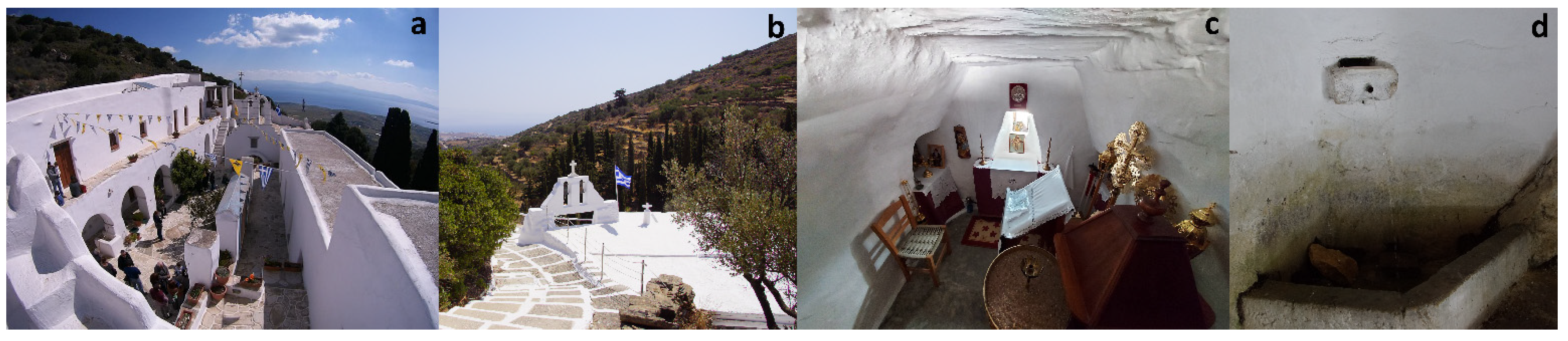
There are two key sites in the case study area southwest of Marpissa (Figure 15). The first is the Monastery of Agios Georgios at Lagkada, built in 1664 (Aliprantis 1970) and dedicated to the military/equestrian Saint George (Figure 16a). The second is the cave church of the Metamorphosis (Transfiguration of Christ) (Figure 16b,c), constructed in the late 17th or early 18th century and connected with the sacred spring of Afklaki nearby (Figure 16d), used by Arsenios (1800–1877), monk at the Monastery of Agios Georgios, in the 19th century as a stopover during his travels to other monasteries and churches inland. The cave church was later dedicated to and renamed after Arsenios, following his canonisation as a new saint by the Ecumenical Patriarchate in 1967. Both cult sites are located within the catchment area of the village of Marpissa. From the outskirts of Marpissa, a cemented path leads to both sites, following the original route of an older footpath. A network of other interlocking paths (most of them currently abandoned and overgrown with vegetation) mark the only means of communication between the villages of Marpissa, Marmara and Prodromos in the plain and the numerous private outlying churches and other landed properties on the way to the two cult sites of Agios Georgios Monastery and the Metamorphosis/Agios Arsenios cave church. The aforementioned network of paths also physically connects the numerous extra-mural chapels and outlying churches with other agricultural installations (farmhouses and stables, winepresses and threshing floors, wells and field terraces) that sprang up in the post-medieval landscape of the island after settlement spread outside the nucleated settlements in the Ottoman era (Figure 17).
Physical movement by paths during post-medieval times, from the village house to the fields on a daily basis, or from villages to outlying churches once a year to celebrate the memory of a saint at the local paniyiri, created narrative stories and palimpsests of memories that connected ancestral and present-day individual and community experiences with the topography. The rural landscape between the permanent settlements and the sacred destination was not devoid of structures, life and senses; it was filled with stories, myths and superstitions, farming activities, countryside smells and the sounds of grazing animals and church bells (cf. Tilley 1994, pp. 30–31; Bintliff 2013, pp. 49–50). The view of this scenery, next to the outlying chapels along the paths and amongst the cultivated fields to which people showed their respect by making the sign of the cross, created a kind of kinetic axis for the community, connecting the domestic with the sacred and the past with the present. Thus, the physical landscape transformed into a sacred one and was woven into ritual and kinetic linear space, as worshippers, villagers and travellers traversed the distance from the coast or from the closest village to the outlying church or the monastery and back again (cf. Williamson 2021, pp. 289–91). As also argued in the context of ancient paths and embodied ritual movement (cf. Connerton 1989; Williamson 2021, p. 56), or in the case of Byzantine Constantinople (Manolopoulou 2019), movement following physical paths, as well as visual paths or ‘sightlines’ between the individual and the sacred site (in our case, the outlying churches along the way), created ‘sacred roads’ as a vehicle for everyday/domestic and ritual processions. Travelling on foot or on donkeyback to the cave church of the Metamorphosis/Agios Arsenios on August 5th–6th and 17th–18th or to the Monastery of Agios Georgios at Lagkada on 23 April was/is not an easy task, considering that the uphill journey would take someone 60 and 70 min, respectively, from the outskirts of Marpissa. Local pilgrimage is an important issue to consider (this was what kept paniyiria alive), with people travelling on the eve and on the festive day to attend the mass, receive the saint’s blessing and participate in the festive meal. On such occasions, pilgrims from outside the island would have been extremely rare, and this was likely the case during the Byzantine period as well (Papaconstantinou 2007, p. 362).
No matter how long the journey would take for both local pilgrims and visitors/travellers, it was the physical challenge of the journey and the contact with nature and the religious monuments of the historical past that adorned the final destination (the sacred sites of veneration) and the in-between ‘stations’ (the multiple outlying churches) with a higher value (cf. Andriotis 2009, p. 67; Gilchrist 2020, p. 25). Admittedly, in some cases, Paros included, the process of sacred travel, as defined above, would currently seem more like ‘religious tourism’ than ‘faith-based pilgrimage’, with participants submitting their spirituality and senses to experience the sacred and embark on a private journey to their personal exploration of the place’s cultural roots (Thouki 2019). The travel to join the annual religious festivals of Saint George, the Transfiguration of Christ or Saint Arsenios involves the full engagement with all material things in the domesticated landscape of the island, such as the humble churches and sacred or demonic caves, the field walls and sacred stones, the winding paths, and the springs and streams, similar to the case of major pilgrimages elsewhere (Andriotis 2009; Eade 2020). This fascination with nature and humble sacred landmarks required no official sponsorship, but rural shrines were kept alive by travellers and nearby communities through the established local religious festive days and visitation (cf. Grehan 2014, pp. 89, 117). Even if the actual liturgy at the place of destination could be simply “abstract doctrines and formulas” for some, the travel to the place of veneration and the visual contact with numerous other cult locations along the way constitute expressive worship and an unmediated communication with sacred landscapes and God (Aspray 2021).
6. Conclusions
Summing up the main points that this article has raised, I should first underline that this comprises a preliminary attempt to understand the distribution of a large number of extra-mural and outlying churches on the Cycladic island of Paros in the framework of religious space and maritime identities. A number of historical conjectures contributed immensely to the creation of sacred landscapes on this and other Aegean islands through the construction of private town and rural churches, the demarcation of individual/family or community/parochial identities, the establishment of stopping-sites in ‘pilgrimage’ kinetic rituals and the consolidation of the ownership of the landscape. Within the framework of the general tendency to shift our focus from the imperial or global to the local, the post-medieval history and material culture of the Cyclades in general and Paros in particular highlight the remarkable resilience of island communities and the Church through their ability to network and adapt to political change, socio-economic crisis and religious needs.
The historical circumstances in the Aegean, with island communities being largely self-governing, distant from the imperial capital, safe from direct Ottoman presence, but at the same time, exposed to piratical and other threats in the middle of a nautical no man’s land, created a diverse human geography. The local Christian islanders, some of whom engaged in long-distance trading and other activities, not only gave way to women managing their dowries and property, but also gradually brought back cash and prestigious goods, elevating their status in the community and investing in the construction of churches. Through the establishment of shrines dedicated to certain saintly figures, along with annual commemoration and visitation to these sites, both men and women were able to contribute to the sanctification of their surrounding landscapes as stages for their dramas and successes. The fear of pirates and corsairs, pandemics and infertility, gave rise to the cult of saints, attributing these saints not only with healing and protective powers, but also with the capacity for harm and vengeance against the wicked and impious. This form of ‘agrarian’ or ‘maritime’ religion was enriched with superstitions and traditions that echoed the social and sexual transformation of women through female demonic figures (e.g., harpies and witches) associated with the female nature. The cult of certain female saints was intended to overcome misfortunes associated with maternity and chthonic powers. Overall, the construction and distribution of churches on the island of Paros (and perhaps other islands in the Aegean during the same period), and the ideology associated with them, give the Church a genuine resilience, deconstructing the polarised model of institutional versus domestic religious practice.
Funding
This research received no external funding.
Institutional Review Board Statement
Not applicable.
Informed Consent Statement
Not applicable.
Data Availability Statement
Not applicable.
Acknowledgments
This article falls within the research activities of the Unlocking the Sacred Landscapes of Cyprus research project and network (UnSaLa-CY, EXCELLENCE/1216/0362), co-funded by the European Regional Development Fund and the Republic of Cyprus through the Research and Innovation Foundation, and hosted by the Archaeological Research Unit of the University of Cyprus. The author would like to express his gratitude to Giorgos Papantoniou (Trinity College Dublin) for his editorial assistance, encouragement, and inspiring discussions on sacred landscapes and pilgrimage. Special thanks go to Christine E. Morris (Trinity College Dublin) for her editorial assistance and the linguistic refinement of my article and to the anonymous reviewers for their valuable comments and suggestions.
Conflicts of Interest
The author declares no conflict of interest.
References
- Abulafia, David. 2019. Islands in Context, A.D. 400–1000. In Change and Resilience: The Occupation of Mediterranean Islands in Late Antiquity. Edited by Miguel Ángel Cau Ontiveros and Catalina Mas Florit. Oxford and Philadelphia: Oxbow, pp. 285–96. [Google Scholar]
- Aliprantis, Nikos C. 1970. Μεταβυζαντινά μνημεία της Πάρου. Επετηρίς Εταιρείας Κυκλαδικών Μελετών 8: 412–83. [Google Scholar]
- Aliprantis, Nikos C. 2020. Προσκυνητές στα Ιερά Σεβάσματα της Λατρείας των Παριανών Προγόνων. H Συμφωνία των Ερειπίων, 13ος-18ος αι. Athens: Pariana. [Google Scholar]
- Andriotis, Konstantinos. 2009. Sacred Site Experience: A Phenomenological Study. Annals of Tourism Research 36: 64–84. [Google Scholar] [CrossRef]
- Asdrachas, Spyros I. 1985. The Greek Archipelago: A Far-Flung City. In Maps and Map-Makers of the Aegean. Edited by Vasilis Sphyroeras, Anna Avramea and Spyros Asdrachas. Athens: Olkos, pp. 235–48. [Google Scholar]
- Asdrachas, Spyros I. 2018. Observations on Greek Insularity. In Islands of the Ottoman Empire. Edited by Antonis Hadjikyriacou. Princeton: Markus Wiener Publishers, pp. 3–36. [Google Scholar]
- Aspray, Barnabas. 2021. How Can Phenomenology Address Classic Objections to Liturgy? Religions 12: 236. [Google Scholar] [CrossRef]
- Baun, Jane. 2016. Apocalyptic Panagia: Some Byways of Marian Revelation in Byzantium. In The Cult of the Mother of God in Byzantium: Texts and Images. Edited by Leslie Brubaker and Mary B. Cunningham. London: Routledge, pp. 199–211. [Google Scholar]
- Bent, James Theodore. 1885. The Cyclades or Life among the Insular Greeks. London: Longmans, Green, and Co. [Google Scholar]
- Bintliff, John L. 2007. Considerations for Creating an Ottoman Archaeology in Greece. In Between Venice and Istanbul: Colonial Landscapes in Early Modern Greece. Edited by Siriol Davies and Jack L. Davis. Princeton: The American School of Classical Studies at Athens, pp. 221–36. [Google Scholar]
- Bintliff, John L. 2013. Contextualizing the Phenomenology of Landscape. In Human Expeditions: Inspired by Bruce Trigger. Edited by Stephen Chrisomalis and Andre Costopoulos. Toronto: University of Toronto Press, pp. 41–50. [Google Scholar]
- Boomert, Arie, and Alistair Bright. 2007. Island Archaeology: In Search of a New Horizon. Island Studies Journal 2: 3–26. [Google Scholar] [CrossRef]
- Bouras, Charalampos. 2001. Βυζαντινή και Μεταβυζαντινή Aρχιτεκτονική στην Ελλάδα. Athens: Melissa. [Google Scholar]
- Braudel, Fernand. 1972. The Mediterranean and the Mediterranean World in the Age of Philip II. Translated by Siân Reynolds. New York: Harper & Row. [Google Scholar]
- Broodbank, Cyprian. 2000. An Island Archaeology of the Early Cyclades. Cambridge: Cambridge University Press. [Google Scholar]
- Brown, Peter. 1981. The Cult of the Saints. Its Rise and Function in Latin Christianity. Chicago: The University of Chicago Press. [Google Scholar]
- Brown, Peter. 2000. Enjoying the Saints in Late Antiquity. Early Medieval Europe 9: 1–24. [Google Scholar] [CrossRef]
- Cheetham, Nicolas. 1981. Medieval Greece. New Haven: Yale University Press. [Google Scholar]
- Cherry, John F. 1981. Pattern and Process in the Earliest Colonization of the Mediterranean Islands. Proceedings of the Prehistoric Society USA 47: 41–68. [Google Scholar] [CrossRef]
- Cherry, John F., and Thomas P. Leppard. 2015. A Little History of Mediterranean Island Prehistory. In The Cambridge Prehistory of the Bronze and Iron Age Mediterranean. Edited by A. Bernard Knapp and Peter van Dommelen. Cambridge: Cambridge University Press, pp. 10–24. [Google Scholar] [CrossRef]
- Connerton, Paul. 1989. How Societies Remember. Cambridge: Cambridge University Press. [Google Scholar] [CrossRef]
- Constantakopoulou, Christy. 2007. The Dance of the Islands: Insularity, Networks, the Athenian Empire, and the Aegean World. Oxford: Oxford University Press. [Google Scholar]
- Cormack, Robin. 1985. Writing in Gold: Byzantine Society and Its Icons. Oxford: Oxford University Press. [Google Scholar]
- Crow, Jim, Sam Turner, and Athanasios K. Vionis. 2011. Characterizing the Historic Landscapes of Naxos. Journal of Mediterranean Archaeology 24: 111–37. [Google Scholar] [CrossRef]
- Ćurčić, Slobodan. 1991. Architecture. Oxford Dictionary of Byzantium 1: 157–59. [Google Scholar]
- Ćurčić, Slobodan. 2010. Architecture in the Balkans: From Diocletian to Süleyman the Magnificent. New Haven: Yale University Press. [Google Scholar]
- Davis, Jack L. 1991. Contributions to a Mediterranean Rural Archaeology: Historical Case Studies from the Ottoman Cyclades. Journal of Mediterranean Archaeology 4: 131–215. [Google Scholar] [CrossRef]
- Dimitrokallis, Georgios. 1993. Τυπολογική και μορφολογική θεώρηση της μεταβυζαντινής ναοδομίας των Κυκλάδων. In Εκκλησίες στην Ελλάδα μετά την Άλωση (1453–1830). Athens: National Polytechnic University Publications, vol. 4, pp. 185–12. [Google Scholar]
- DiNapoli, Robert J., and Thomas P. Leppard. 2018. Islands as Model Environments. The Journal of Island and Coastal Archaeology 13: 157–60. [Google Scholar] [CrossRef] [Green Version]
- Dubisch, Jill. 1995. In a Different Place. Pilgrimage, Gender, and Politics at a Greek Island Shrine. Princeton: Princeton University Press. [Google Scholar]
- Eade, John. 2020. The Invention of Sacred Places and Rituals: A Comparative Study of Pilgrimage. Religions 11: 649. [Google Scholar] [CrossRef]
- Evans, John D. 1973. Islands as Laboratories of Culture Change. In The Explanation of Culture Change: Models in Prehistory. Edited by Colin Renfrew. London: Duckworth, pp. 517–20. [Google Scholar]
- Forbes, Hamish. 2007. Meaning and Identity in a Greek Landscape: An Archaeological Ethnography. Cambridge: Cambridge University Press. [Google Scholar]
- Gardiner, Mark. 2012. Oral Tradition, Landscape and the Social Life of Place-Names. In Sense of Place in Anglo-Saxon England. Edited by Richard Jones and Sarah Semple. Donington: Shaun Tyas, pp. 16–30. [Google Scholar]
- Gasparis, Charalambos. 2016. O λοιμός και το τάμα: Oι εκκλησίες του Aγίου Aθανασίου στον μεσαιωνικό Χάνδακα. In Μαργαρίται. Μελέτες στη Μνήμη του Μανόλη Μπορμπουδάκη. Edited by Manolis S. Patedakis and Kostas D. Giapitsoglou. Siteia: Panagia Akroteriane Foundation, pp. 411–27. [Google Scholar]
- Georgiadi, Anastasia. 2014. Θολωτές κατασκευές στους μεταβυζαντινούς ναούς της Πάρου. In Ιστορία Δομικών Κατασκευών, 2ο Διεπιστημονικό Συνέδριο. 5–7 Δεκεμβρίου 2014, Ξάνθη. Conference Proceedings. Xanthi: Department of Architectural Engineering and City Council of Xanthi. [Google Scholar]
- Gerstel, Sharon E. J. 1998. Painted Sources for Female Piety in Byzantium. Dumbarton Oaks Papers 52: 89–111. [Google Scholar] [CrossRef]
- Gerstel, Sharon E. J. 2005. The Byzantine Village Church: Observations on its Location and on Agricultural Aspects of its Program. In Les Villages dans l’Empire Byzantin, IVe–XVe Siècle. Edited by Jacques Lefort, Cécile Morrisson and Jean-Pierre Sodini. Paris: Lethielleux, pp. 165–78. [Google Scholar]
- Gibson, Erin. 2007. The Archaeology of Movement in a Mediterranean Landscape. Journal of Mediterranean Archaeology 20: 61–87. [Google Scholar] [CrossRef]
- Gilchrist, Roberta. 2012. Medieval Life: Archaeology and the Life Course. Woodbridge: The Boydell Press. [Google Scholar]
- Gilchrist, Roberta. 2020. Sacred Heritage: Monastic Archaeology, Identities, Beliefs. Cambridge: Cambridge University Press. [Google Scholar]
- Given, Michael. 2000. Agriculture, Settlement and Landscape in Ottoman Cyprus. Levant 32: 215–36. [Google Scholar] [CrossRef] [Green Version]
- Given, Michael, Oscar Aldred, Kevin Grant, Peter McNiven, and Tessa Poller. 2019. Interdisciplinary Approaches to a Connected Landscape: Upland Survey in the Northern Ochils. Proceedings of the Society of Antiquaries of Scotland 148: 83–111. [Google Scholar] [CrossRef]
- Gordon, Jody Michael. 2018. Insularity and Identity in Roman Cyprus: Connectivity, Complexity, and Cultural Change. In Insularity and Identity in the Roman Mediterranean. Edited by Anna Kouremenos. Oxford and Philadelphia: Oxbow, pp. 4–40. [Google Scholar]
- Grehan, James. 2014. Twilight of the Saints. Everyday Religion in Ottoman Syria and Palestine. Oxford: Oxford University Press. [Google Scholar]
- Hadjikyriacou, Antonis. 2014. Local Intermediaries and Insular Space in Late-18th Century Ottoman Cyprus. Osmanlı Araştırmaları/The Journal of Ottoman Studies 44: 427–56. [Google Scholar] [CrossRef] [Green Version]
- Hadjikyriacou, Antonis. 2018. Envisioning Insularity in the Ottoman World. In Islands of the Ottoman Empire. Edited by Antonis Hadjikyriacou. Princeton: Markus Wiener Publishers, pp. vii–xix. [Google Scholar]
- Hall, Mark A. 2010. Wo/men Only? Marian Devotion in Medieval Perth. In The Cult of Saints and the Virgin Mary in Medieval Scotland. Edited by Steve Boardman and Eila Williamson. Woodbridge: The Boydell Press, pp. 105–24. [Google Scholar]
- Hartnup, Karen. 2004. On the Beliefs of the Greeks. Leo Allatios and Popular Orthodoxy. Leiden: Brill. [Google Scholar]
- Holst-Warhaft, Gail. 2008. Death and the Maiden: Sex, Death, and Women’s Laments. In Women, Pain and Death: Rituals and Everyday Life on the Margins of Europe and Beyond. Edited by Evy Johanne Håland. Newcastle upon Tyne: Cambridge Scholars Publishing, pp. 15–33. [Google Scholar]
- Imber, Colin. 2002. The Ottoman Empire, 1300–1650: The Structure of Power. Basingstoke: Palgrave Macmillan. [Google Scholar]
- İnalcık, Halil. 1972. The Ottoman Decline and its Effects upon the Reaya. In Aspects of the Balkans, Continuity and Change, Contributions to the International Balkan Conference held at UCLA, Oct. 23–8, 1969. Edited by Henrik Birnbaum and Speros Vryonis. Paris: Mouton, pp. 338–54. [Google Scholar]
- İnalcık, Halil. 1973. The Ottoman Empire: The Classical Age, 1300–1600. New York: Praeger Publishers. [Google Scholar]
- İnalcık, Halil. 1991. The Emergence of Big Farms, Çiftliks: State, Landlords and Tenants. In Landholding and Commercial Agriculture in the Middle East. Edited by Çağlar Kayder and Faruk Tabak. Albany: State University of New York Press, pp. 17–34. [Google Scholar]
- Kalas, Veronica. 2009. Sacred Boundaries and Protective Borders: Outlying Chapels of Middle Byzantine Settlements in Cappadocia. In Sacred Landscapes in Anatolia and Neighboring Regions. British Archaeological Reports International Series 2034; Edited by Charles Gates, Jacques Morin and Thomas Zimmermann. Oxford: Archaeopress, pp. 79–91. [Google Scholar]
- Kasdagli, Aglaia E. 1991. Gender Differentiation and Social Practice in Post-Byzantine Naxos. In The Byzantine Tradition After the Fall of Constantinople. Edited by John J. Yiannias. Charlottesville: University of Virginia Press, pp. 61–94. [Google Scholar]
- Kenna, Margaret E. 1976. Houses, Fields, and Graves: Property and Ritual Obligation on a Greek Island. Ethnology 15: 21–34. [Google Scholar] [CrossRef]
- Kiel, Machiel. 1990. Byzantine Architecture and Painting in Central Greece, 1460–1570: Its Demographic and Economic Basis According to the Ottoman Census and Taxation Registers for Central Greece Preserved in Istanbul and Ankara. Byzantinische Forschungen 16: 429–46. [Google Scholar]
- Kiel, Machiel. 1997. The Rise and Decline of Turkish Boeotia, 15th–19th Century. In Recent Developments in the History and Archaeology of Central Greece. British Archaeological Reports International Series 666; Edited by John L. Bintliff. Oxford: Archaeopress, pp. 315–58. [Google Scholar]
- Kiel, Machiel. 2007. The Smaller Aegean Islands in the 16th–18th Centuries According to Ottoman Administrative Documents. In Between Venice and Istanbul: Colonial Landscapes in Early Modern Greece. Edited by Siriol Davies and Jack L. Davis. Princeton: The American School of Classical Studies at Athens, pp. 35–54. [Google Scholar]
- Knapp, Bernard A. 2008. Prehistoric and Protohistoric Cyprus: Identity, Insularity, and Connectivity. Oxford: Oxford University Press. [Google Scholar]
- Kolovos, Elias. 2006. H Nησιωτική Kοινωνία της Άνδρου στο Oθωμανικό Πλαίσιο. Πρώτη προσέγγιση με Bάση τα Oθωμανικά ‘Eγγραφα της Καϊρείου Βιβλιοθήκης (1579–1821). Andros: Kaireios Vivliothiki. [Google Scholar]
- Kolovos, Elias. 2007. Insularity and Island Society in the Ottoman Context: The Case of the Aegean Island of Andros (Sixteenth to Eighteenth Centuries). Turcica 39: 49–122. [Google Scholar] [CrossRef]
- Kolovos, Elias. 2018. Introduction: Across the Aegean. In Across the Aegean: Islands, Monasteries and Rural Societies in the Ottoman Greek Lands. Edited by Elias Kolovos. Istanbul: The Isis Press, pp. 9–28. [Google Scholar]
- Konstantellou, Theodora. 2020. Saint John the Baptist Rigodioktes. A Holy Healer of Fevers in the Church of the Panaghia at Archatos, Naxos (1285). Deltion of the Christian Archaeological Society 41: 173–96. [Google Scholar]
- Kontogiorgis, Giorgos D. 1982. Κοινωνική Δυναμική και Πολιτική Aυτοδιοίκηση: Oι Eλληνικές Κοινότητες της Τουρκοκρατίας. Athens: Ekdoseis Livani. [Google Scholar]
- Krantonelli, Alexandra. 1991. Ιστορία της Πειρατείας στους Mέσους Xρόνους της Τουρκοκρατίας, 1538–1699. Athens: Estia. [Google Scholar]
- Krausmüller, Dirk. 2016. Making the Most of Mary: The Cult of the Virgin in the Chalkoprateia from Late Antiquity to the Tenth Century. In The Cult of the Mother of God in Byzantium: Texts and Images. Edited by Leslie Brubaker and Mary B. Cunningham. London: Routledge, pp. 219–45. [Google Scholar]
- Lape, Peter V. 2004. The Isolation Metaphor in Island Archaeology. In Voyages of Discovery: The Archaeology of Islands. Edited by Scott M. Fitzpatrick. Westport: Praeger, pp. 223–32. [Google Scholar]
- Lefebvre, Henri. 1991. The Production of Space. Translated by Donald Nicholson-Smith. Oxford: Blackwell. [Google Scholar]
- Legrand, Emile. 1889. Notice biographique sur Jean et Théodose Zygomalas. In Recueil de Textes et de Traductions Publié par les Professeurs de l’Ecole des Langues Orientales Vivantes (VIIIe Congrès International des Orientalistes, Stockholm 1889). Paris: E. Leroux, pp. 69–264. [Google Scholar]
- Magennis, Hugh. 2001. Warrior Saints, Warfare, and the Hagiography of Aelfric of Eynsham. Traditio 56: 27–51. [Google Scholar] [CrossRef]
- Malamut, Elisabeth. 1988. Les îles de l’Empire Byzantin: VIIIe-XIIe Siècles. Paris: Publications de la Sorbonne. [Google Scholar]
- Manolopoulou, Vicky. 2019. Processing Time and Space in Byzantine Constantinople. In Unlocking Sacred Landscapes: Spatial Analysis of Ritual and Cult in the Mediterranean. Edited by Giorgos Papantoniou, Christine E. Morris and Athanasios K. Vionis. Nicosia: Astrom Editions, pp. 155–67. [Google Scholar]
- Margry, Peter J. 2008. Secular Pilgrimage: A Contradiction in Terms? In Shrines and Pilgrimage in the Modern World: New Itineraries into the Sacred. Edited by Peter J. Margry. Amsterdam: Amsterdam University Press, pp. 13–46. [Google Scholar]
- Meri, Yousef. 2015. The Cult of Saints and Pilgrimage. In The Oxford Handbook of the Abrahamic Religions. Edited by Adam J. Silverstein and Guy G. Stroumsa. Oxford: Oxford University Press, pp. 499–517. [Google Scholar] [CrossRef]
- Miller, William. 1908. The Latins in the Levant: A History of Latin Greece (1204–1566). London: John Murray. [Google Scholar]
- Nelson, Robert S. 2011–2012. ‘And So, with the Help of God’: The Byzantine Art of War in the Tenth Century. Dumbarton Oaks Papers 65/66: 169–92. [Google Scholar]
- Nixon, Lucia. 2006. Making a Landscape Sacred: Outlying Churches and Icon Stands in Sphakia, Southwestern Crete. Oxford: Oxbow. [Google Scholar]
- Orlandos, Anastasios K. 1961. Oι Mεταβυζαντινοί Nαοί της Πάρου. Aρχείον των Βυζαντινών Μνημείων της Ελλάδος 9. Athens: Estia. [Google Scholar]
- Orlandos, Anastasios K. 1964. Oι Mεταβυζαντινοί Nαοί της Πάρου. Aρχείον των Βυζαντινών Μνημείων της Ελλάδος 10. Athens: Estia. [Google Scholar]
- Ousterhout, Robert G. 2019. Eastern Medieval Architecture: The Building Traditions of Byzantium and Neighboring Lands. New York: Oxford University Press. [Google Scholar]
- Papaconstantinou, Arietta. 2007. The Cult of Saints: A Haven of Continuity in a Changing World? In Egypt in the Byzantine World, 300–700. Edited by Roger S. Bagnall. Cambridge: Cambridge University Press, pp. 350–67. [Google Scholar]
- Papadopoulou, Chryssanthi. 2010. Aphrodite and the Fleet in Classical Athens. In Brill’s Companion to Aphrodite. Edited by Amy C. Smith and Sadie Pickup. Leiden: Brill, pp. 217–33. [Google Scholar]
- Papagiannaki, Anthousa. 2010. Aphrodite in Late Antique and Medieval Byzantium. In Brill’s Companion to Aphrodite. Edited by Amy C. Smith and Sadie Pickup. Leiden: Brill, pp. 321–46. [Google Scholar]
- Papantoniou, Giorgos. 2012. Religion and Social Transformations in Cyprus: From the Cypriot ‘Basileis’ to the Hellenistic ‘Strategos’. Leiden: Brill. [Google Scholar]
- Papantoniou, Giorgos. 2013. Cypriot Autonomous Polities at the Crossroads of Empire: The Imprint of a Transformed Islandscape in the Classical and Hellenistic Periods. Bulletin of the American Schools of Oriental Research 370: 169–205. [Google Scholar] [CrossRef]
- Papantoniou, Giorgos, and Christine E. Morris. 2019. Kyprogenes Aphrodite: Between Political Power and Cultural Identity. In Gods of Peace and War in the Myths of the Mediterranean People. Edited by Konstantinos I. Soueref and Ariadni Gartziou-Tatti. Ioannina: Ministry of Culture and Sports—University of Ioannina, pp. 147–73. [Google Scholar]
- Papantoniou, Giorgos, and Athanasios K. Vionis. 2020. Popular Religion and Material Responses to Pandemic: The Christian Cult of the Epitaphios during the COVID-19 Crisis in Greece and Cyprus. Ethnoarchaeology 12: 85–117. [Google Scholar] [CrossRef]
- Patelis, Panagiotis I. 2004. Παρεκκλήσια και Eξωκλήσια της Πάρου. Paros: Holy Pilgrimage of Panagia Hekatontapyliane. [Google Scholar]
- Pouqueville, François Charles Hugues Laurent. 1821. Voyage dans la Grèce. Paris: Chez Firmin Didot, père et fils. vol. 5. [Google Scholar]
- Rackham, Oliver. 2012. Island Landscapes: Some Preliminary Questions. Journal of Marine and Island Cultures 1: 87–90. [Google Scholar] [CrossRef] [Green Version]
- Rainbird, Paul. 2007. The Archaeology of Islands. Cambridge: Cambridge University Press. [Google Scholar]
- Renfrew, Colin, and Malcolm Wagstaff. 1982. An Island Polity: The Archaeology of Exploitation in Melos. Cambridge: Cambridge University Press. [Google Scholar]
- Roussos, Konstantinos. 2017. Reconstructing the Settled Landscape of the Cyclades: The Islands of Paros and Naxos during the Late Antique and Early Byzantine Centuries. Leiden: Leiden University Press. [Google Scholar]
- Seifreid, Rebecca, and Tuna Kalaycı. 2019. An Exploratory Spatial Analysis of the Churches in the Southern Mani Peninsula, Greece. In Unlocking Sacred Landscapes: Digital Humanities and Ritual Space. Edited by Giorgos Papantoniou, Apostolos Sarris, Christine E. Morris and Athanasios K. Vionis. Open Archaeology 5. Berlin: De Gruyter, pp. 519–39. [Google Scholar] [CrossRef]
- Slot, Ben J. 1982. Archipelagus turbatus: Les Cyclades entre Colonisation Latine et Occupation Ottomane, c. 1500–1718. 2 vols, Leiden: Nederlands Instituut voor het Nabije Oosten. [Google Scholar]
- Slot, Ben J. 2001. H Σίφνος: μία ειδική νησιωτική οικονομία (15ος-17ος αιώνας). In Πρακτικά A΄ Διεθνούς Σιφναϊκού Συμποσίου. Σίφνος 25-28 Ιουνίου 1998. Βυζάντιο, Φραγκοκρατία, Νεότεροι Χρόνοι. Athens: Etaireia Sifnaikon Meleton, vol. 2, pp. 59–72. [Google Scholar]
- Smyrlis, Kostis. 2020. Monasteries, Society, Economy, and the State in the Byzantine Empire. In The Oxford Handbook of Christian Monasticism. Edited by Bernice M. Kaczynski. Oxford: Oxford University Press. [Google Scholar] [CrossRef]
- Sollars, Luke. 2005. Settlement and Community: Their Location, Limits and Movement through the Landscape of Historical Cyprus. Ph.D. thesis, University of Glasgow, Glasgow, UK. [Google Scholar]
- Spiridonakis, Vasilis G. 1977. Essays on the Historical Geography of the Greek World in the Balkans during the Turkokratia. Thessaloniki: Institute for Balkan Studies. [Google Scholar]
- Thomas, Julian. 2001. Archaeologies of Place and Landscape. In Archaeological Theory Today. Edited by Ian Hodder. Cambridge: Polity Press, pp. 165–86. [Google Scholar]
- Thouki, Alexis. 2019. The Role of Ontology in Religious Tourism Education–Exploring the Application of the Postmodern Cultural Paradigm in European Religious Sites. Religions 10: 649. [Google Scholar] [CrossRef] [Green Version]
- Tilley, Christopher. 1994. A Phenomenology of Landscape: Places, Paths and Monuments. Oxford: Berg. [Google Scholar]
- Tournefort, Joseph Pitton de. 1718. A Voyage into the Levant Performed by Command of the Late French King. London: D. Browne, vol. 1. [Google Scholar]
- Vasileiadis, Dimitrios V. 1962. Aι επιπεδόστεγοι μεταβυζαντιναί βασιλικαί των Κυκλάδων. Επετηρίς Εταιρείας Κυκλαδικών Μελετών 2: 318–645. [Google Scholar]
- Vatin, Nicolas, and Gilles Veinstein. 2004. Insularités Ottomanes. Paris: Institut Français d‘ études Anatoliennes. [Google Scholar]
- Vidali, Maria. 2009. Γη και Χωριό. Τα Εξωκλήσια της Τήνου. Athens: Futura. [Google Scholar]
- Vionis, Athanasios K. 2012. A Crusader, Ottoman, and Early Modern Aegean Archaeology: Built Environment and Domestic Material Culture in the Medieval and Post-Medieval Cyclades, Greece (13th–20th Century AD). Leiden: Leiden University Press. [Google Scholar]
- Vionis, Athanasios K. 2014. The Archaeology of Landscape and Material Culture in Late Byzantine-Frankish Greece. In Recent Developments in the Long-Term Archaeology of Greece. Edited by John L. Bintliff. Pharos 20.1. Leuven: Peeters, pp. 313–46. [Google Scholar] [CrossRef]
- Vionis, Athanasios K. 2016. A Boom-Bust Cycle in Ottoman Greece and the Ceramic Legacy of Two Boeotian Villages. Journal of Greek Archaeology 1: 353–84. [Google Scholar]
- Vionis, Athanasios K. 2017. Imperial Impacts, Regional Diversities and Local Responses: Island Identities as Reflected on Byzantine Naxos. In Imperial Lineages and Legacies in the Eastern Mediterranean: Recording the Imprint of Roman, Byzantine and Ottoman Rule. Edited by Rhoads Murphey. London and New York: Routledge, pp. 165–96. [Google Scholar]
- Vionis, Athanasios K. 2019a. The Spatiality of the Byzantine/Medieval Rural Church: Landscape Parallels from the Aegean and Cyprus. In Unlocking Sacred Landscapes: Spatial Analysis of Ritual and Cult in the Mediterranean. Edited by Giorgos Papantoniou, Christine E. Morris and Athanasios K. Vionis. Nicosia: Astrom Editions, pp. 67–83. [Google Scholar]
- Vionis, Athanasios K. 2019b. The Materiality of Death, the Supernatural and the Role of Women in Late Antique and Byzantine Times. Journal of Greek Archaeology 4: 252–69. [Google Scholar]
- Vionis, Athanasios K., and Giorgos Papantoniou. 2019. Economic Landscapes and Transformed Mindscapes in Cyprus from Roman Times to the Early Middle Ages. In Change and Resilience: The Occupation of Mediterranean Islands in Late Antiquity. Edited by Miguel Ángel Cau Ontiveros and Catalina Mas Florit. Oxford and Philadelphia: Oxbow, pp. 257–84. [Google Scholar]
- Vogiatzakis, Ioannis N., Maria Zomeni, and Antoinette M. Mannion. 2017. Characterising Landscapes: Conceptual and Methodological Challenges Exemplified in the Mediterranean. Land 6: 14. [Google Scholar] [CrossRef] [Green Version]
- White, Joshua M. 2018. Piracy and Law in the Ottoman Mediterranean. Stanford: Stanford University Press. [Google Scholar]
- Whittaker, Robert J. 1998. Island Biogeography: Ecology, Evolution, and Conservation. Oxford: Oxford University Press. [Google Scholar]
- Williamson, Christina G. 2021. Urban Rituals in Sacred Landscapes in Hellenistic Asia Minor. Leiden: Brill. [Google Scholar]
- Zerlentis, Pericles G. 1913. Ιστορικαί ‘Eρευναι περί τας Εκκλησίας των Nήσων της Aνατολικής Μεσογείου Θαλάσσης. Hermoupolis: Nicolaos G. Freris, vol. 1. [Google Scholar]
Figure 1.
The Aegean, the Cyclades, and other locations mentioned in the text (map by the author).

Figure 2.
Imported tableware (late 16th–late 18th centuries) found on the island of Paros. (a). Bartmann salt-glazed stoneware jug from Germany; (b). salt-glazed stoneware gin bottle from the Netherlands; (c). armorial maiolica table basin from Faenza; (d). maiolica table basin from Montelupo; (e). coffee cup from Kütahya; (f). painted plate from Çanakkale; (g). painted ibrik from Çanakkale (photos by the author).

Figure 3.
The number of monasteries and churches built in towns and in the countryside on the island of Paros from the 5th to the 18th century (data and graph by the author).
Figure 3.
The number of monasteries and churches built in towns and in the countryside on the island of Paros from the 5th to the 18th century (data and graph by the author).

Figure 4.
Ninety monastic, town and country/rural churches on the island of Paros, dated by their surviving inscriptions (data and graph by the author).
Figure 4.
Ninety monastic, town and country/rural churches on the island of Paros, dated by their surviving inscriptions (data and graph by the author).

Figure 5.
Representative examples of rural churches on Paros. (a). Pointed barrel-vaulted, free-standing church; (b). barrel-vaulted (north chapel) and pointed barrel-vaulted (south chapel) twin churches; (c). pointed barrel vault, interior; (d). pseudo-vaulted free-standing church; (e). pseudo-vaulted twin churches; (f). pseudo vault with stone slabs, interior (photos by the author).

Figure 6.
Representative examples of domed churches on Paros. (a). Single-aisled, Agios Konstantinos, Paroikia; (b). Free cross, Agios Nikolaos, Paroikia (photos by the author).
Figure 6.
Representative examples of domed churches on Paros. (a). Single-aisled, Agios Konstantinos, Paroikia; (b). Free cross, Agios Nikolaos, Paroikia (photos by the author).

Figure 7.
Monasteries (red crosses) and churches (black crosses) in the countryside of the island of Paros and its offshore islets (map by the author).
Figure 7.
Monasteries (red crosses) and churches (black crosses) in the countryside of the island of Paros and its offshore islets (map by the author).

Figure 8.
The distances between monastic and rural churches and their nearest settlement on the island of Paros. The community of Archilochos refers to the two neighbouring settlements of Marmara and Prodromos (data and graph by the author).
Figure 8.
The distances between monastic and rural churches and their nearest settlement on the island of Paros. The community of Archilochos refers to the two neighbouring settlements of Marmara and Prodromos (data and graph by the author).

Figure 9.
The altitude of monastic and rural churches on Paros (data and graph by the author).

Figure 10.
The town of Paroikia and its immediate territory in the 1950s. Red circles indicate the extent of the town in post-medieval times and the location of monasteries and churches visible on the photograph, together with their distance from the market (Agora) of Paroikia in the Ottoman era (© The History of Paros private collection, Paros, adapted by the author).

Figure 11.
A diagram (in scale) showing the direct relationship between residents in the villages of Marpissa, Marmara/Prodromos and Lefkes (in yellow) and their private chapels (in green) or their landed property around rural churches (in black). It also shows the distribution of monasteries (in red) and rural churches (in blue) endowed to monasteries either in the same region (indicated with a link) or outside it (diagram by the author).

Figure 12.
A graph showing the number of churches dedicated to certain saintly figures. The graph includes the names of the saints to whom the dedication occurs in more than five monastic, settlement and outlying churches (data and graph by the author).
Figure 12.
A graph showing the number of churches dedicated to certain saintly figures. The graph includes the names of the saints to whom the dedication occurs in more than five monastic, settlement and outlying churches (data and graph by the author).

Figure 13.
A graph showing the number of churches dedicated to saintly figures possessing certain qualities and powers (data and graph by the author).
Figure 13.
A graph showing the number of churches dedicated to saintly figures possessing certain qualities and powers (data and graph by the author).

Figure 14.
A pie chart showing the percentage of post-medieval churches dedicated to Mary, other female saints, Christ and male saints on the island of Paros (data and graph by the author).
Figure 14.
A pie chart showing the percentage of post-medieval churches dedicated to Mary, other female saints, Christ and male saints on the island of Paros (data and graph by the author).

Figure 15.
A map of the central east plain of Paros with settlements (yellow dots), monasteries (red crosses), outlying churches (black crosses) and paths (dotted lines) leading to the Monastery of Agios Georgios and the cave church of the Transfiguration/Agios Arsenios (map by the author).
Figure 15.
A map of the central east plain of Paros with settlements (yellow dots), monasteries (red crosses), outlying churches (black crosses) and paths (dotted lines) leading to the Monastery of Agios Georgios and the cave church of the Transfiguration/Agios Arsenios (map by the author).

Figure 16.
(a). Monastery of Agios Georgios; (b). exterior of cave church of the Transfiguration/Agios Arsenios; (c). interior of cave church; (d). spring of Afklaki (photos by the author).
Figure 16.
(a). Monastery of Agios Georgios; (b). exterior of cave church of the Transfiguration/Agios Arsenios; (c). interior of cave church; (d). spring of Afklaki (photos by the author).

Figure 17.
Various agricultural installations in the post-medieval and early modern countryside of Marpissa: (a). farmhouse and stables; (b). winepress; (c). threshing floor; (d). path and field terraces (photos by the author).
Figure 17.
Various agricultural installations in the post-medieval and early modern countryside of Marpissa: (a). farmhouse and stables; (b). winepress; (c). threshing floor; (d). path and field terraces (photos by the author).

Publisher’s Note: MDPI stays neutral with regard to jurisdictional claims in published maps and institutional affiliations. |
© 2022 by the author. Licensee MDPI, Basel, Switzerland. This article is an open access article distributed under the terms and conditions of the Creative Commons Attribution (CC BY) license (https://creativecommons.org/licenses/by/4.0/).
Share and Cite
MDPI and ACS Style
Vionis, A.K. The Construction of Sacred Landscapes and Maritime Identities in the Post-Medieval Cyclades Islands: The Case of Paros. Religions 2022, 13, 164. https://0-doi-org.brum.beds.ac.uk/10.3390/rel13020164
AMA Style
Vionis AK. The Construction of Sacred Landscapes and Maritime Identities in the Post-Medieval Cyclades Islands: The Case of Paros. Religions. 2022; 13(2):164. https://0-doi-org.brum.beds.ac.uk/10.3390/rel13020164
Chicago/Turabian StyleVionis, Athanasios K. 2022. "The Construction of Sacred Landscapes and Maritime Identities in the Post-Medieval Cyclades Islands: The Case of Paros" Religions 13, no. 2: 164. https://0-doi-org.brum.beds.ac.uk/10.3390/rel13020164
Note that from the first issue of 2016, this journal uses article numbers instead of page numbers. See further details here.