
Geoturist Evaluation of Geosites in the Tuchola Forest Biosphere Reserve (N Poland)


1
Faculty of Earth Sciences and Spatial Management, Nicolaus Copernicus University, ul. Lwowska 1, 87-100 Toruń, Poland
2
Institute of Geology, Adam Mickiewicz University, B. Krygowskiego 12, 61-680 Poznań, Poland
*
Author to whom correspondence should be addressed.
Resources 2022, 11(2), 13; https://0-doi-org.brum.beds.ac.uk/10.3390/resources11020013
Submission received: 20 December 2021
/
Revised: 21 January 2022
/
Accepted: 23 January 2022
/
Published: 26 January 2022
(This article belongs to the Special Issue Geodiversity Assessment: What, Why and How?)
Abstract
:The geotourist evaluation of 32 geosites, including mineral deposits occurrence (1), petrological (12), sedimentological (2), and geomorphological (9), as well as hydrological and hydrogeological (8) sites, located in the area of Tuchola Forest Biosphere Reserve (TFBR), has been carried out. The study aims to provide a qualitative assessment of geodiversity via the evaluation of abiotic nature objects, as well as propose modifications in geotourist valuation criteria, for the purpose of applying it to the areas located in the Central European Plains. The evaluated geosites represent both perfect examples of typical features for the physiography of the TFBR, as a young glacial landscape, e.g., erratic boulders, glaciofluvial landforms, postglacial landforms, and lakes or peatbogs, as well as values proving the uniqueness of the area on both regional and international scales, e.g., disused underground lignite mine “Montania”. High scores of geotourist attractiveness (between 36 and 44 points) have been received by 14 evaluated geosites (1 mineral deposits occurrence geosite, 4 petrological geosites, 1 sedimentological geosite, and 5 geomorphological geosites, as well as 3 hydrological and hydrogeological geosites). The remaining 18 geosites have received a medium score (between 25 and 34 points). Three areas of high concentration of geosites, which overlap with the boundaries of Tuchola, Wdecki, and Zaborski (area of the greatest diversity of highly-ranked geosites) landscape parks, were distinguished. The authors proposed geosites that require improving their accessibility to enhance the geotourist attractiveness, recognized the necessity of marking out geotourist trails in the most attractive and diversified areas, and noticed the influence of extreme weather phenomena (whirwinds) on changes in the geotourist attractiveness of some geosites. It is believed that the results of the conducted evaluation may favorably affect the importance, position, and publicity of the whole area by supplementing the well-recognized biodiversity with the geodiversity presented in the study.
1. Introduction
The Tuchola Forest (in Polish: Bory Tucholskie) constitutes one of the largest forest complexes in the northern part of Poland, which belongs to the plains of Central Europe. It is situated in the postglacial area, within the range of the Weichselian glaciation (Last Glaciation, Vistulian). The area of the Tuchola Forest Biosphere Reserve (TFBR) is unique, both in terms of landscape and nature. It is characterized by exceptional biodiversity [1,2,3,4]; however, literature devoted to the subject lacks specific studies concerning its geodiversity, geological heritage, and geotourist potential, as well as the evaluation and valorization of abiotic objects (geosites). Unlike biodiversity, the term geodiversity, and by extension the whole concept of geodiversity, have appeared in Poland relatively recently [5]. Internationally, the notion of geodiversity was used for the first time in German literature (Geodiversität), in the study by Wiedenbein [6]; simultaneously, this term was introduced into English literature (geodiversity) by Sharples in 1993 [7,8]. Since then, the definition of geodiversity has undergone repeated modifications [7,8,9,10,11,12,13,14,15,16,17,18]. At the same time, the methods of geodiversity assessment (valorization) have also changed [5,14,17,19,20,21,22,23,24]. In the relevant literature, geodiversity is associated with geological heritage, as a neutral term, in terms of values describing the diversity of abiotic nature that can be found on Earth, whereas geological heritage is a term burdened with values used for the identification of all the components of geodiversity selected for the purpose of geoconservation [25]. Geodiversity, defined in the Polish language, by Kozłowski [26], as a diversification of abiotic natural monuments, can be qualitatively assessed and quantitatively measured for a given area [8,27].
The most essential elements of the material geological heritage are called ‘geological sites’, frequently referred to as geosites (geomorphosites, geotopes). They are spatially limited fragments of the Earth’s crust or its surface, as well as effects of processes occurring at these sites in the past or at present, which we are capable of defining and determining their value, in terms of the heritage [28]. The majority of studies, concerning the assessment of geosites and geotourist evaluation in Poland, focus on upland and mountain areas, e.g., [29,30,31,32,33,34,35,36], whereas a significantly smaller number of studies are devoted to geodiversity, geotourism, and geological heritage in postglacial lowland areas, which constitute the largest part of the country, e.g., [37,38,39,40,41,42]. One of the few examples of projected geoparks in central and northern Poland, for which only a preliminary assessment of geotourist attractiveness has been made, is the “Postglacial land of Drawa and Dębnica Rivers Geopark” located in NW Poland [42]. Therefore, applying evaluation system to the area of the TFBR required a certain modification of specific criteria. The objective of the following study is filling this gap, by means of providing a qualitative assessment of geodiversity, evaluating the abiotic nature objects in TFBR, and proposing modifications in geotourist valuation criteria, for the purpose of applying it to the areas located in the Central European Plains. The authors of the study have chosen such a conceptual and methodological approach to evaluating geotourist objects as an essential part of assessing the geodiversity of the area.
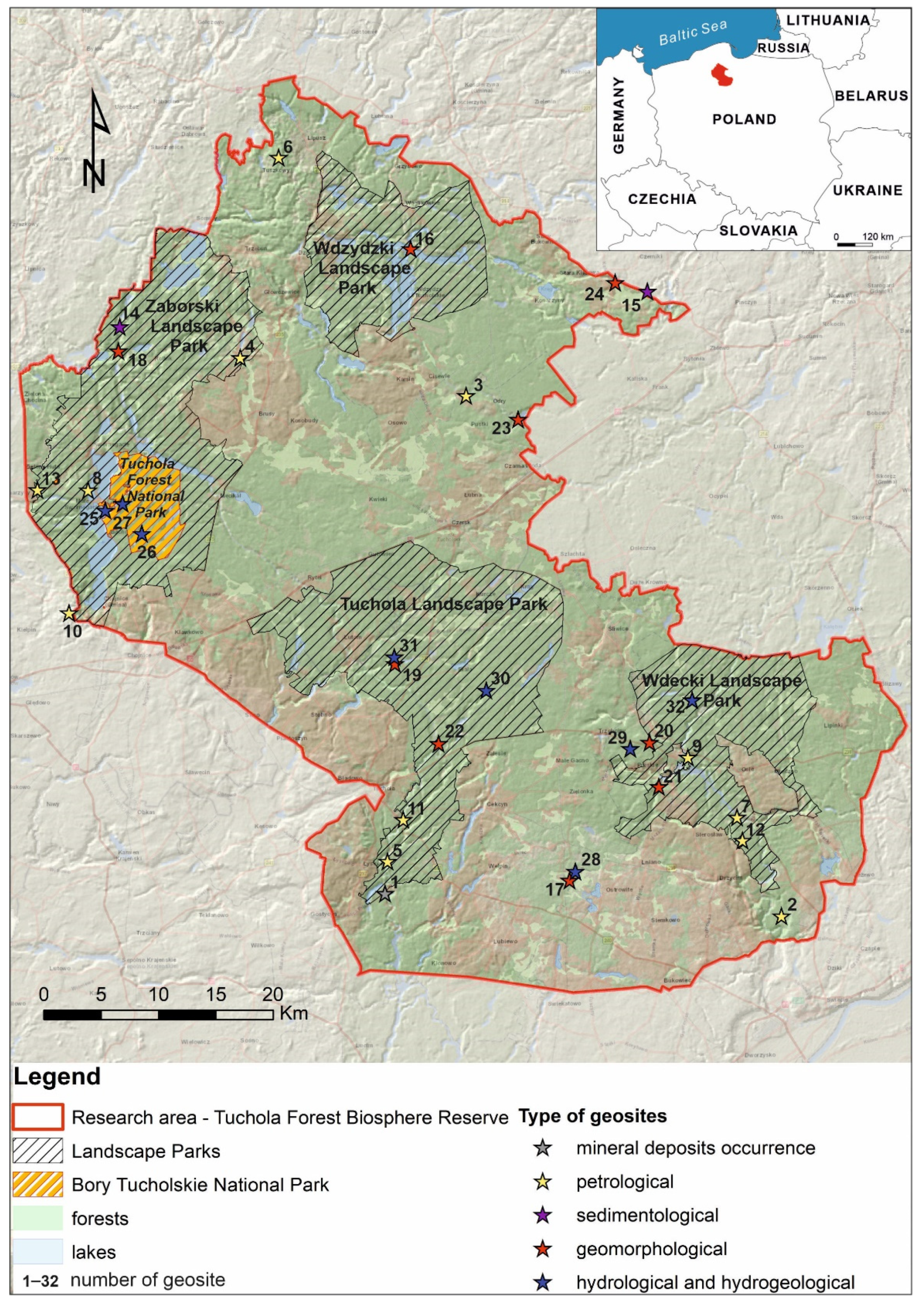
2. Study Area—Tuchola Forest Biosphere Reserve (TFBR)
As far as the study area is concerned, the following article has concentrated on the Tuchola Forest Biosphere Reserve (TFBR), which includes within its borders the most valuable parts of the Tuchola Forest, in terms of both nature and scenery. The study area covers 3195 km2 (Figure 1 and Figure 2). More than 86% of its area is currently overgrown with woodland. The TFBR was created under the Man and Biosphere Programme (MAB), which has been implemented by UNESCO all over the world, since 1970. Biosphere reserves are areas that contain outstanding natural features and preserve their natural character. Simultaneously, they present typical features of habitats, which are globally diversified and established for both conservation and scientific reasons, as well as for the purposes of both ecological education, according to the rules of sustainable development, enhancement of environmental protection, and other promotional purposes. The TFBR can be found on the list of eleven such areas in Poland and is the largest of all, in terms of the surface area. It was founded on 2 June 2010 and, in accordance with the requirements of the UNESCO-MAB programme, it was divided into three zones [4,43]: (1) the core zone—occupying the surface area of approximately 7881 hectares and constituting the most valuable areas in the Tuchola Woodland, in terms of natural beauty, the Tuchola Forest National Park, covering the area of 4613.05 hectares and containing 25 nature reserves. (2) The buffer zone—covering the surface area, in excess of 104,631 hectares, it is formed of four landscape parks: Tuchola Landscape Park, Wdecki Landscape Park, Zaborski Landscape Park, and Wdzydzki Landscape Park (Figure 1), as well as 19 nature reserves (faunistic, peat-bog, floristic, floristic aquatic, landscape, forest, and archaeological nature reserves). This zone also includes areas surrounding six nature reserves located beyond the borders of landscape parks. (3) The transit zone— which occupies an area of approximately 207,000 hectares.
The TFBR covers an area of 22 communes, belonging to four counties in two voivodeships: Kuyavian-Pomeranian (13 communes) and Pomeranian (9 communes). The main forms of human activity in the TFBR are forestry, tourism, and recreation, as well as wood processing, fishery, and agriculture [43]. In 2018, an update of the borders of the TFBR was proposed, assuming the extension of the existing reserve, which entailed the acquisition of some parts of the neighboring administrative, as well as physical and geographical units [44]. Currently, the work is still in progress on this update. The area of TFBR has been regularly affected by extreme weather conditions in recent years, including whirlwinds. In 2012, a whirlwind, which was passing through a corridor between 300 and 800 m wide, caused the complete destruction of approximately 550 hectares of forest. In 2017, another whirlwind resulted in the devastation of around 1000 hectares of forest. Finally, in 2021, a whirlwind destroyed about 1000 hectares of forest [45,46].
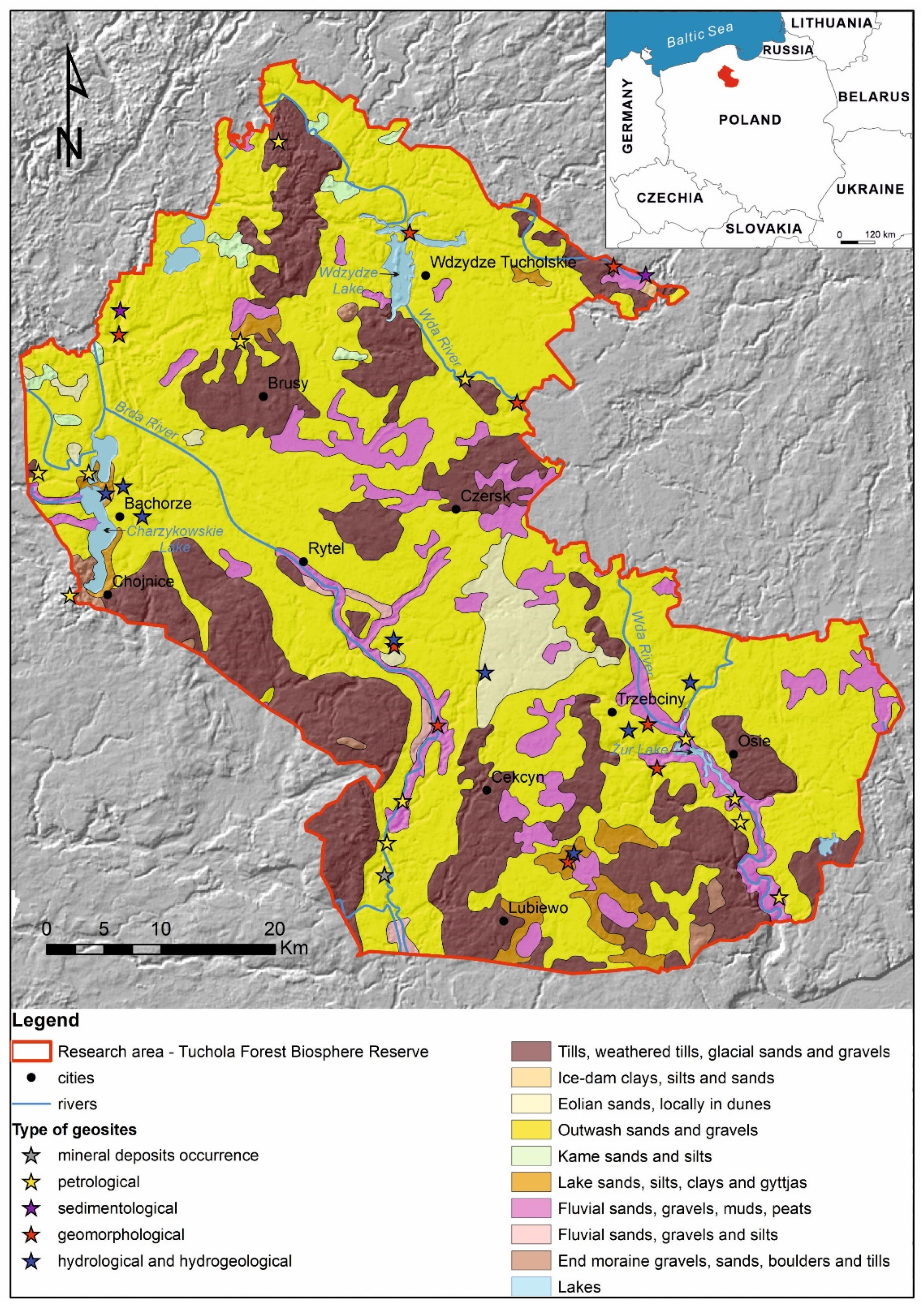
According to geographical regionalization [47,48], TFBR is situated within the province of the Central European Plain, sub-province of Southern Baltic Lakelands, and two physical and geographical macro-regions, i.e., the Southern-Pomeranian Lakeland (99.3% of the study area) and Eastern-Pomeranian Lakeland (0.7% of the study area). Within them, 8 physical and geographical mesoregions and 32 micro-regions can be distinguished. The largest mesoregion, the Tuchola Forest, occupies 56% of the area of the TFBR. In terms of the area, it is followed by other mesoregions, such as Świecie Upland, Charzykowska Plain, Northern Krajna Lakeland, the Brda River Valley, Kashubian Lake District, and Starogard Lakeland [47]. In terms of type of sediments, these areas within the maximum extent of the Fennoscandian Ice Sheet during the Last Glaciation belong to outwash plains with lakes (for example, the micro-regions of the Brda Outwash and the Wda Outwash Plains) and young glacial moraine plateaux (for instance, the micro-region of Brusy-Karsin-Czersk Upland), criss-crossed by valleys discharging glaciofluvial water from outwash plains (for example, the micro-region of the Brda River Valley). The study area is characterized by lowland and lakeland landscapes, as well as the diversity concerning altitudes above sea level (from approximately 66.5 m above sea level in the southern part up to 206.2 m above sea level in the northern part [4]).
2.1. Biodiversity
In the area of the TFBR, there occurs a range of natural systems marked on the Natura 2000 list of conservation objectives as priority ecological systems. They include, among others, moorlands, mid-forest lobelia lakes, and dystrophic lakes with charophyte grassland, as well as peat bogs of the Atlantic type and deciduous forests [4,43]. They are inhabited by numerous rare, relict, and protected species of vascular and sporulated plants and fungi, as well as by vertebrate and invertebrate animals, including representatives of endangered species [4,43]. Almost the entire study area, with the exception of moraine hills, is covered with one of the largest pine forests in Poland [49]. The forest area is composed mainly of pine monoculture, with a small mixture of the common white birch, aspen, and pedunculate oak [50]. The lower parts of the forest are most commonly overgrown with European rowan and juniper, whereas the forest floor consists of moss, as well as many species of berries and heather [3].
The crust vegetation of the Tuchola Forest, in the present form, constitutes the remains of the former Tuchola Primeval Forest, overgrown predominantly by beech and pine, which were accompanied by larger patches of forest, consisting of other deciduous trees, such as oak, hornbeam, aspen, or lime. Forest communities began to grow in these areas soon after the end of the Weichselian glaciation. Initially, they constituted birch and pine forest complexes. Over the years, natural factors, which later combined with anthropogenic factors, led to a significant restructuring of the primary forest ecosystems. As the climate was getting warmer, pine was gradually replaced by such species as lime or oak [1,51]. Along with the emergence of human settlement, the process of the gradual degradation of forest flora began. It suddenly accelerated, together with the development of industry. Today’s forest structure is shaped by middle-aged stands coming from planting, whereas specimens that are over a century old are rather uncommon [51]. The area of the TFBR is distinguishable from neighboring areas by virtue of the fact that a great number of rare and endangered species, as well as relicts, can be found [3]. Primeval forest ecosystems currently occupy rather small areas and are under strict protection. Among them one can find the yew reserve by Mukrz Lake or the primary deciduous forest reserve with the wild service tree stands in the vicinity of Tleń [50]. Currently, the most common forest type is the fresh coniferous forest, which overgrows podzolic soils on sands of outwash plains. In addition to natural forest sites, essential elements of the Tuchola Forest flora are concentrations of bog and peat vegetation, as well as diverse flora of lichens, which has around 300 species [1,2,3].
2.2. Geology and Geomorphology
According to geological regionalization of Poland, without the Cenozoic cover, the area of the area of TFBR belongs to the Kościerzyna Segment of the Kościerzyna-Puławy Synclinorium and the Pomeranian Segment of the Mid-Polish Anticlinorium [52]. The Cenozoic sediments in the study area reach a thickness of approximately 200 m. The Paleogene and Neogene sediments are represented by mudstones, sands, and limestones, as well as clays and silts, with some interbedding of lignites (brown coals) [53,54]. During the Pleistocene, the Fennoscandian Ice Sheet repeatedly expanded in the study area. The present relief of the TFBR was shaped during the Last Glaciation (Weichselian glaciation or Vistulian). Its main elements include sandy glaciofluvial outwash plains, which developed in front of the Ice Sheet during the Pomeranian phase of the Weichselian glaciation (Figure 2). In the area of the TFBR, two main outwash plains connected with the drainage basins of the Wda and Brda Rivers (Figure 2). The outwash plains are diversified by numerous kettle-holes, scattered over the entire study area, e.g., [55,56], as well tunnel valleys (subglacial valleys), Holocene river valleys predominantly running from the north-west to the south-east, and aeolian forms—dunes (currently covered by vegetation). The two biggest concentrations of the latter occur on the eastern and western sides of Charzykowskie Lake (Figure 2), as well as in the central part of the study area, between the Czerska Struga and the Bielska Struga Rivers. The depth of the tunnel valleys reaches between 20 and 30 m, whereas their width oscillates between 200 and 2600 m [4]. Within the area of the TFBR, the biggest tunnel valleys run in the approximately longitudinal form. They include the Byszewo tunnel valley, which is 2.3 km wide and 55 km long [57], and the Charzykowskie Lake tunnel valley, which is several hundred meters wide and over 20 km long. Other commonly encountered landforms include end moraines composed of clays, silts, sands, and gravels with boulders (Figure 2). They are mainly located in the western part of the study area, to the south-west of Charzykowskie Lake. Moreover, a significant part of the study area is occupied by the moraine plateaux (moraine uplands), composed of clays formed during the Poznań phase of the Weichselian glaciation. The Holocene sediments are represented by gyttjas, lacustrine chalk, peats, and aggradate muds, as well as clays, sands, and gravels, filling the beds of tunnel valleys, river valleys, and kettle holes (Figure 2).
3. Materials and Methods
In order to conduct the assessment of the current visual condition of geosites and tourist development of their surroundings, a field inspection has been carried out and photographic documentation has been provided. The geosites in the Tuchola Forest Biosphere Reserve (TFBR) have been identified on the basis of in-house and field studies, carried out involving the Central Geosites Register of the Polish Geological Institute–National Research Institute (PGI-NRI) [59]. A detailed analysis of historical archives, such as tourist maps, guidebooks of different regions, local magazines, and Internet resources, has been conducted. The locations of the 23 geosites that have been evaluated in this study come from the Central Geosites Register of PGI-NRI [59], whereas 9 geosites have been proposed by the authors of the article on the basis of the remaining sources (tourist maps, guidebooks of different regions, local magazines, and Internet resources). The natural objects presented in this study constitute a representative selection, including geosites, typically taking into consideration the geological history of the region, as well as unique specimens or forms.
The geotourist evaluation of the geosites in TFBR has been conducted on the basis of the criteria proposed by Dmytrowski and Kicińska [60], with modifications by the authors (Table 1). There are 5 basic values and 19 assessment criteria that have been selected. The basic values are as follows: I—intrinsic value of the site, II—positioning value of the site, III—cultural value of the site, IV—scope of information on the site and its availability, and V—tourist development of the site (Table 1). The necessity to modify the geotourist evaluation criteria, by the authors of the study, has resulted from the need to adjust them to the lowland character of the TFBR, since the majority of publications, concerning geotourist evaluations, involve upland and mountain areas, e.g., [29,30,31,33,34,35,61]. The changes had content-related character. The value (I) indicates the several criteria inappropriate to the study area, which have been rejected, such as: the occurrence of peculiar geological structures (for instance, sedimentary, erosional, or tectonic), as well as the occurrence of petrographic and mineralogical peculiarities in the rocks. In view of the inability to carry out the detailed geological studies and the lack of available data, this criterion can only be treated as complementary criteria [62]. However, the educational value of the geosites has been taken into account by adding the criterion of thematic differentiation [32]. Another change has been introduced to the criterion concerning the positioning value of the site (II), in relation to tourism centers or destinations. The threshold distance of 5 km has been extended to 10 km, after taking into account the lowland nature of the terrain relief and possibility of visiting the geosites within the framework of cycling tourism, which is not always possible in mountain areas. The cultural value (III) has been supplemented by a criterion concerning the connection of a geosite with religion, which constitutes an essential element of culture. Moreover, the criteria concerning the connection of a monument with history and local folklore or legends, which hitherto were considered separately, have been combined, in view of the difficulty of clear qualification of a given event as a historical fact or folklore tale. As far as an adequate evaluation of the criterion, concerning the scope of information on the site and its availability (IV) is concerned, it has required the separation of the availability of information in literature and the Internet. Finally, when it comes to the notion of tourist development of the site (V), the criterion concerning the assessment of the geotourist trail has been omitted, due to the fact that “no formal trail along which any geotourist attractions are located has been mapped out” [63] and no route concentrating on the values of inanimate nature sites that could perform the function of a geotourist trail.
As a result of the conducted evaluation, two indicators have been obtained. The educational value (EV), calculated as a total sum of all partial assessments for the criteria from I to IV, determines the possibility of the educational use of geosites and necessity to establish or improve legal protection or geotourist development [60]. The geotourist attractiveness value (GA) is calculated as a total sum of the educational value (EV) and geotourist development. In terms of the educational value, geosites could score a minimum of 13 points and maximum of 42 points, whereas, in terms of geotourist attractiveness, they could score 16 and 51 points, respectively. On the basis of the adopted classification, a table has been created that enables the attribution of generalized descriptive assessments (from “low” through “average” to “high”) to a numeric value within a specific score range (Table 2).
Map presentations have been made by means of the ArcGIS software. A digital terrain model has been created, on the basis of data made available by the Central Surveying and Cartographic Documentation Centre, Poland.
4. Results and Discussion
The results of the geosite evaluation in the area of the Tuchola Forest Biosphere Reserve (TFBR) are presented in Table 3, in the form of a map diagram (Figure 3). The selected geosites represent the typical features of the Tuchola Forest as a young glacial landscape and typical values, which prove the uniqueness of this natural site at the regional or international level. Among the evaluated geosites, natural and cultural objects that depict the relationship between man and the natural environment can be found. Since there are various kinds of geosites, they have been allocated to one of the different thematic groups, including such subjects as: mineral deposits occurrence, petrology, sedimentology, and geomorphology, as well as hydrology and hydrogeology (Table 3, Figure 1, Figure 2 and Figure 3).
Geosites have been categorized according to type, which has been determined on the basis of particular dominant features represented by the site. The petrological sites include erratic boulders (9 geosites), erratic boulders in the form of megalithic structures (2), and boulder areas (1). The sedimentological sites are represented by natural exposures (2), while the mineral deposits occurrence site by exposure of lignite-bearing sediments (1). The geomorphological sites consist of the following types: glaciofluvial landforms (3), postglacial landforms (2), and viewing points, providing a view of the particular landforms (3). The hydrological and hydrogeological geosites are represented by lakes (5), peat bogs (2), and springs (1). The list of the selected geosites, along with their division, in terms of type and theme of the site, has been presented in Table 4.
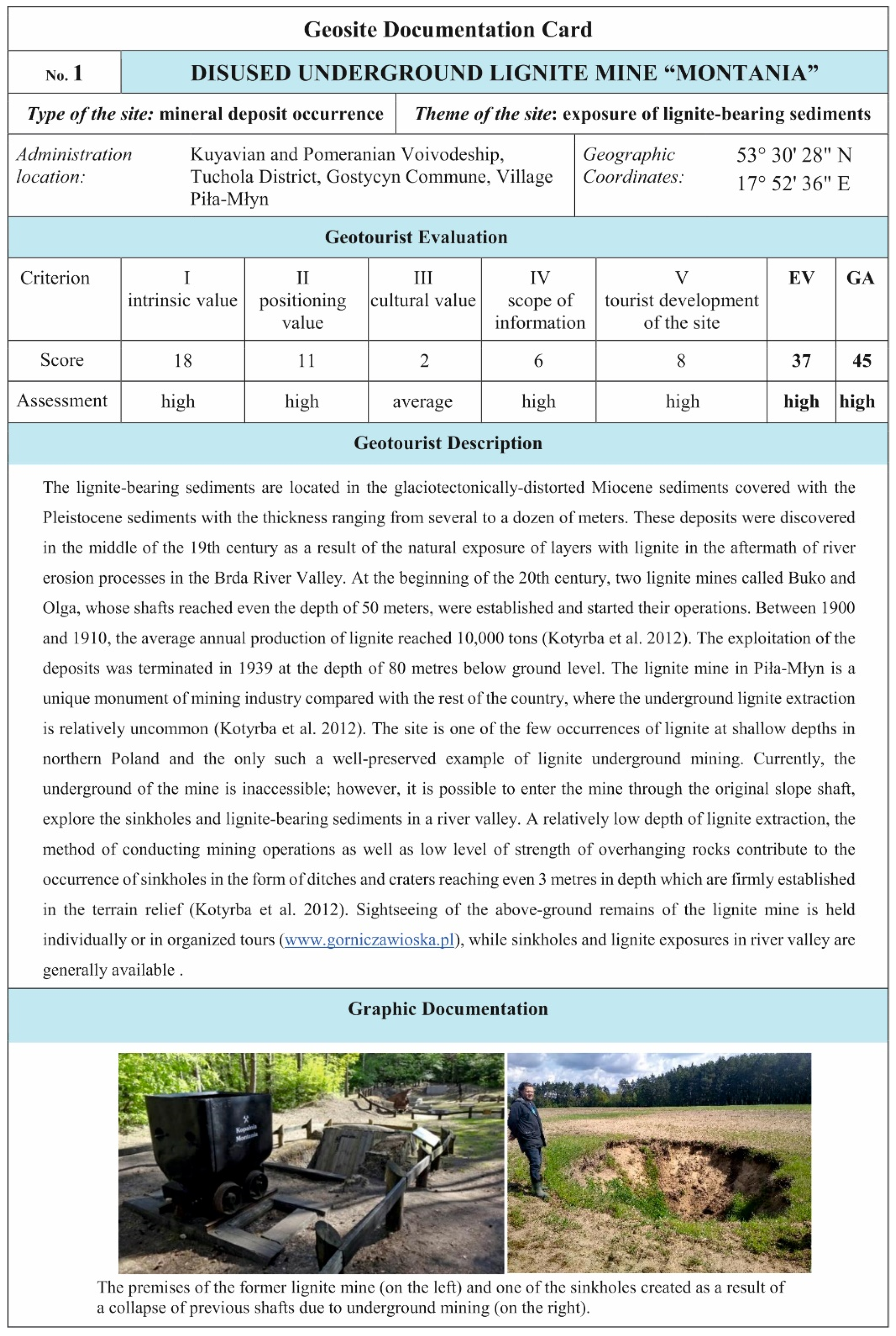
Every single geosite is accompanied by a special geosite documentation card (GDC). A sample card, translated from Polish language, has been presented in Figure 4.
4.1. The Diversity of the Types of Geosites in the Tuchola Forest Biosphere Reserve—Case Studies
4.1.1. Mineral Deposits Occurrence
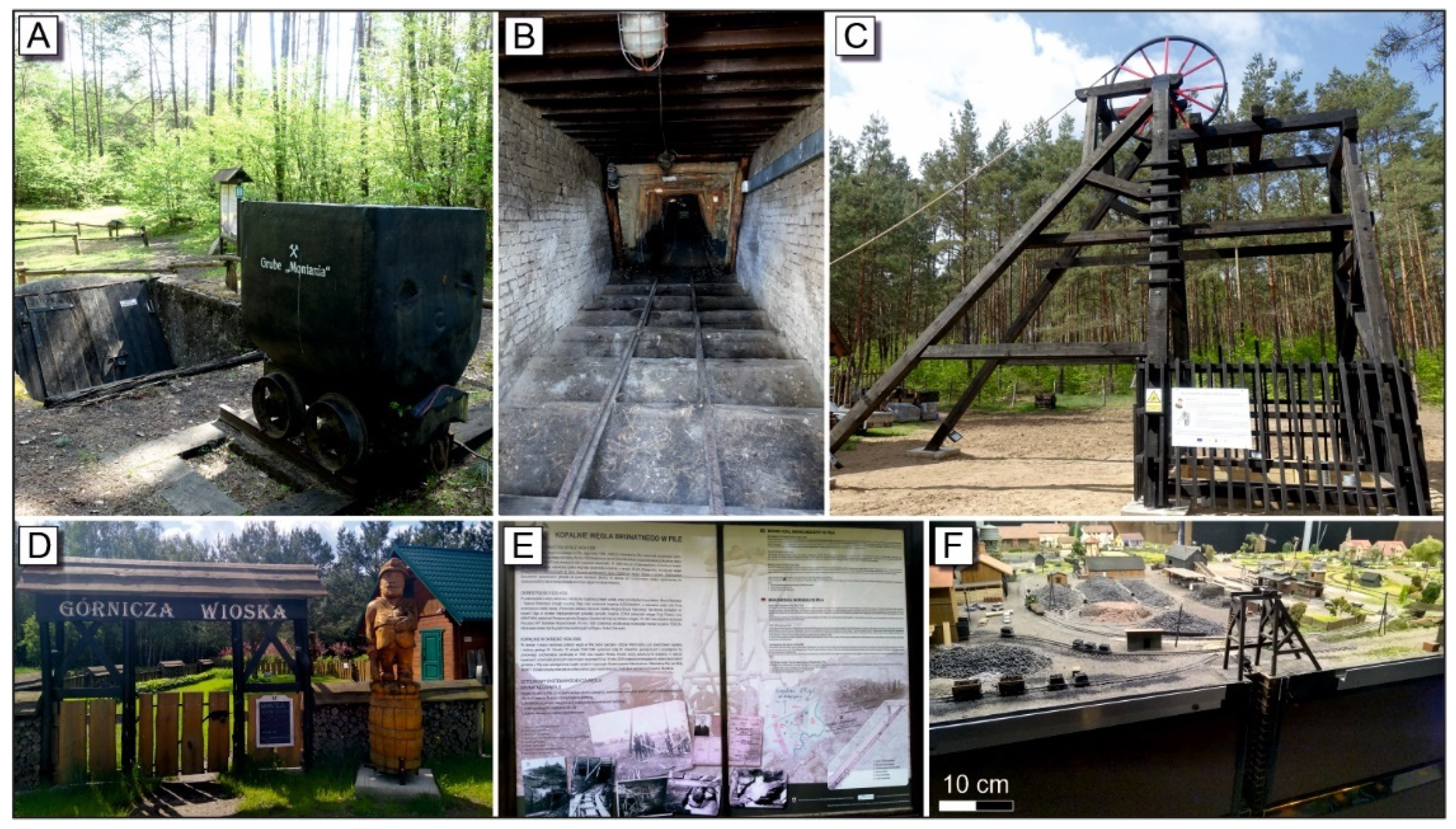
Mineral deposits occurrence geosite is represented by exposure of lignite-bearing sediments in the disused underground lignite mine “Montania” in Piła-Młyn (no. 1; 45 points of Geotourist attractiveness (GA)—Table 3 and Table 4; Figure 4 and Figure 5A–F).
The lignite deposits occur within the Miocene sediments, which were severely distorted glaciotectonically, covered with the Pleistocene sediments. The thickness of the deposits ranges from several to more than a dozen meters. The deposits were discovered in the middle of the 19th century, as a result of the natural exposure of layers with lignite in the aftermath of river erosion processes in the Brda River Valley. At the beginning of the 20th century, two lignite mines, called Buko and Olga, whose shafts reached a depth of 50 m, were established and started their operations. Between 1900 and 1910, the average annual production of lignite reached 10,000 tons [64]. The site is one of the few occurrences of lignite at shallow depths in northern Poland. The mine is a unique monument of lignite mining in Poland, where the extraction of lignite is carried out using mainly open pit methods. The exploitation of the deposits was terminated in 1939, at a depth of 80 m below ground level. A relatively low depth of lignite extraction, the method of conducting mining operations, as well as low levels of strength of overhanging rocks, contributes to the occurrence of sinkholes, in the form of ditches and craters reaching 3 m in depth, which are firmly established in the terrain relief (Figure 4) [64]. The site is currently developed as a “Mining Village”, which, apart from visiting the shafts or examining mining equipment or interactive models, offers the organization of thematic events connected with the mining tradition of the site (Figure 5A–F). The development of the site has been continuously improving for a few years, whereby the geosite demonstrates an increasing attractiveness to tourism and is of supra-regional importance. The remains of the former lignite mine “Montania” in Piła-Młyn, as a result of the evaluation process, has been given the highest score for its geotourist attractiveness (45 points; Table 3), which consists of high educational value (37 points), as well as a high level of geotourist development (8 points) (Table 3 and Table 4).
4.1.2. Petrological Geosites
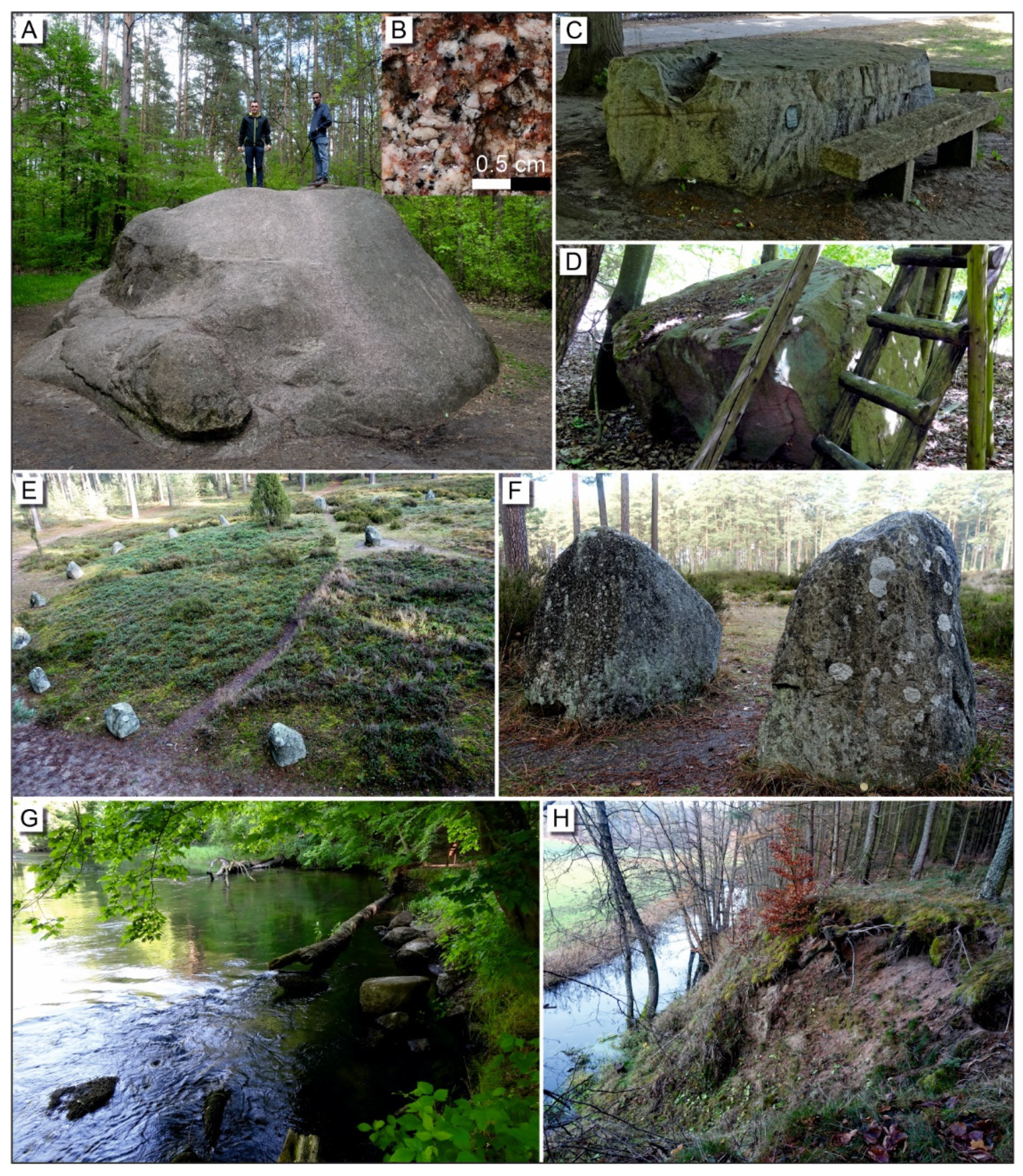
The petrological geosites are represented by erratic boulders (9 geosites), erratic boulders in the form of megalithic structures, and a boulder area (1) (Figure 6A–G). The highest score belongs to the geosite that is typical for the physiography of the Tuchola Forest, namely the erratic boulder called St. Wojciech’s (St. Adalbert’s) Stone, also commonly referred to as the Devil’s Stone (no. 2; 43 points—Table 3 and Table 4; Figure 6A,B). It is the largest erratic boulder in Pomerania and one of the largest in Poland. Its circumference measures 24.5 m, and its height reaches more than 3 m (Figure 6A). It is pink and grey medium-crystalline granite (Figure 6B). The geosite is located on one of the Wda River terraces, approximately one kilometer away from its today’s valley (Figure 1 and Figure 2). The history of the boulder includes numerous local folktales, according to which the stone used to be a pagan sacrificial altar or was used by the devil to barricade the river, whereas St. Wojciech (St. Adalbert) used to preach his sermons from this stone during his pilgrimage to the land of the pagan Prussians. In the vicinity of the geosite, there is a car park and several benches designed for tourists. In spite of the supra-regional importance of the geosites, resulting from the sheer size of the boulder, there is no information board at the site. As a result of the evaluation process, the St. Wojciech’s (St. Adalbert’s) Stone has scored 42 points, which proves its high intrinsic value, as well as high geotourist development (Table 3).
The most highly assessed geosite belonging to the group of megalithic structures is the stone circle complex in Odry (no. 3; 42 points—Table 3 and Table 4), which is situated in the northern part of the study area on the Wda River bank (Figure 1 and Figure 2). Within the boundaries of a reserve, which was established in 1958 and covers an area of 0.17 km2, there are stone barrows and circles made of erratic boulders of Scandinavian origin (Figure 6E,F). They include different kinds of granitoids and gneisses, as well as quartzites. Apart from the petrological value, the area of the reserve has quite a remarkable cultural and botanical value. The site documents the development of cultural heritage, showing traces of early human activity—a unique cemetery of the Goths, originating from between the first and the third century AD. As a result of the examination of the lichen flora, on the surfaces of the boulders, approximately 80 species of lichens, including many typically mountainous and unique lichens, on a national scale have been identified [65]. In the area of the reserve, there are numerous information boards and a viewing terrace.
4.1.3. Sedimentological Geosites
Sedimentological geosites are represented by two natural exposures. The first one—lacustrine chalk in the Kulawa River Valley geosite (no. 14; 38 points—Table 3 and Table 4) exposes layers and/or intercalations of lacustrine chalk of the late Pleistocene/Holocene age, underlain by detritus gyttja. The site locally shows traces of mineral exploitation. The second sedimentological geosite is Bożepole Szlacheckie—late Glacial fossil lake (no. 15; 32 points—Table 3 and Table 4; Figure 6H). The exposed profile consists of sand, silt, and carbonate sediments with lake fauna—ostracods and bivalves—that indicate the occurrence of a lake of increasing depth existing there in the period of late Glacial—early Holocene [59,66].
4.1.4. Geomorphological Geosites
In the area of the TFBR, there are numerous geosites that present a collection of well-developed landforms, typical of young glacial areas, cf. [37,57]. They include glaciofluvial landforms (e.g., meandering river valleys, oxbow lakes, slope scars in slopes of river valleys, tunnel valleys, and outwash plains), postglacial landforms (e.g., kettle holes, dead-ice moraines, kames, and kame terraces), and viewing points that provide access to them (Figure 7).
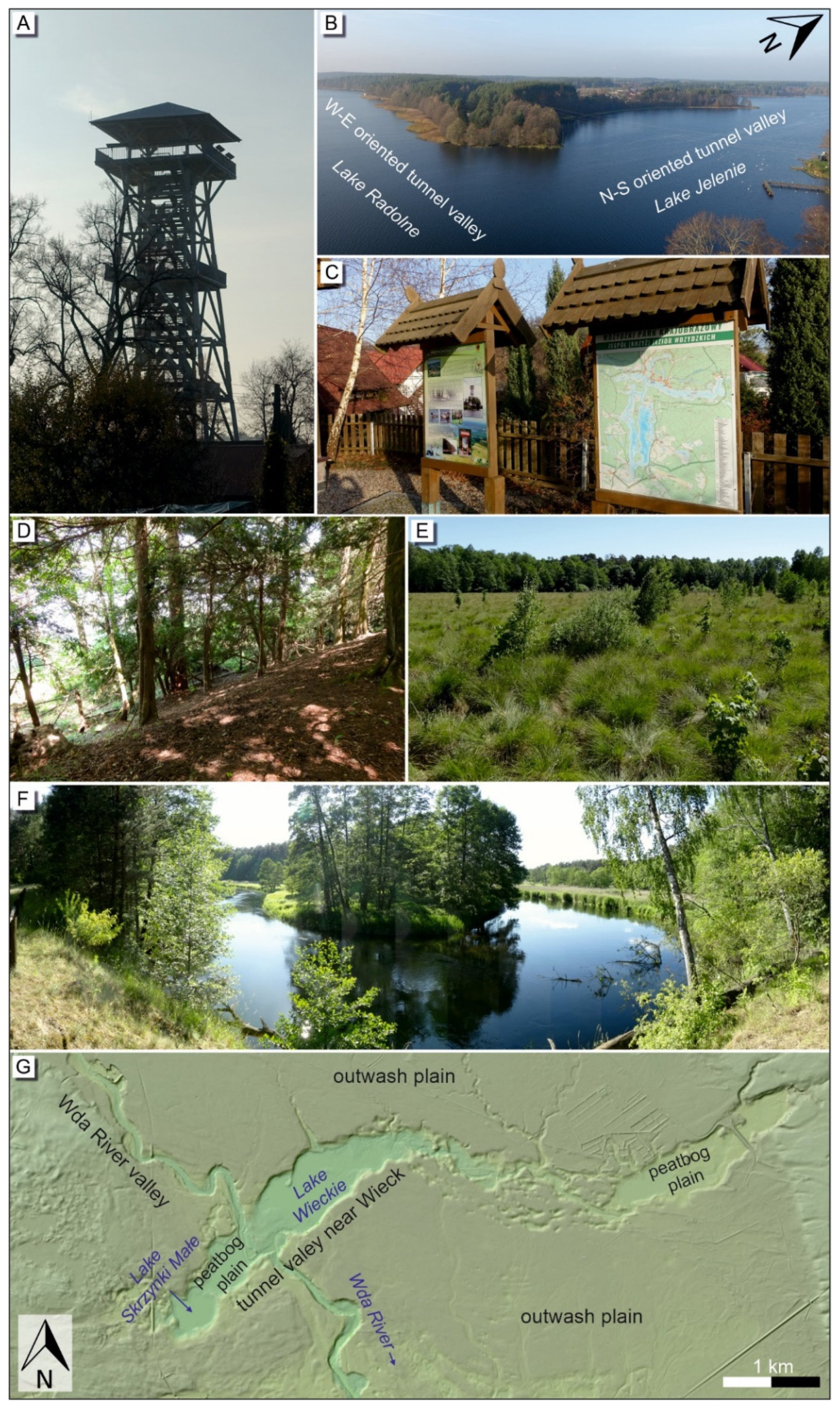
As far as viewing points displaying terrain relief forms are concerned, the highest score has been given to the Wdzydzkie Lake Cross geosite (Wdzydze Lake observation tower) (no. 16; 44 points—Table 3 and Table 4; Figure 7A–C), located in the main tourist resort of the northern part of the TFBR, called Wdzydze Kiszewskie (Figure 1 and Figure 2). From the top of the tower (Figure 7A), at a height of 36 m, the “Wdzydzkie Lakes Cross”, commonly called by the local inhabitants “the Kashubian Sea”, can be seen (Figure 7B). It consists of two intersecting tunnel valleys, measuring 9 and 11 km in length, surrounded by the sands and gravels of the Kościerzyna outwash plain. The first valley, running from the West to the East, is filled with water from Radolne and Gołuń Lakes, whereas the other one, running from the North to the South, is filled with water from Wdzydze and Jelenie Lakes (Figure 7B). With a depth of 72 m, Wdzydze Lake is the sixth deepest lake in Poland. The coastlines of these lakes are highly diversified (Figure 7B). There are 10 islands on these lakes that provide sanctuaries to rare and protected species of wetland birds, as well as habitats for numerous protected species of plants. The largest of them, called Ostrów Wielki, covers an area of 0.96 km2 and is 3 km long, which makes it the second largest lake island in Poland. The Kozłowiec Peninsula, which is a typical example of kame, is perfectly visible from the observation tower in the southern-westerly direction. The observation tower is situated by an asphalt paved road, as well as in the immediate vicinity of walking and cycling trails. There is a car park, catering, and recreation facilities, as well as numerous information boards, installed by the Wdzydzki Landscape Park authorities (e.g., Figure 7C). The geotourist attractiveness of this site has been assessed as high (44 points, Table 3 and Table 4).
Of all the evaluated postglacial landforms, the highest score belongs to the Wierzchlas Reserve geosite (no. 17; 40 points—Table 3 and Table 4), which is located in the central part of the TFBR (Figure 1 and Figure 2). The reserve is distinguished by its unique geomorphological and natural features—it is a cluster of many areal deglaciation forms, connected with the disintegration of the ice sheet into blocks and patches of ice, as well as the process of gradual melting [59]. The highest elevations are kame hills (e.g., Figure 7D), formed out of fine sands and silts, whereas lower hills constitute gravelly, sandy, and clayey dead-ice moraines surrounded by flat surfaces of kame terraces [67]. The largest kettle hole in the immediate neighborhood of the reserve is occupied by the vanishing Mukrz Lake. In the south-eastern part of the reserve, there is another smaller kettle hole, currently almost totally overgrown with peat vegetation (Figure 7E). The reserve constitutes an environmental peculiarity, due to the frequent occurrence of the yew tree (Taxus baccata) in the natural state, which is an extremely rare phenomenon. In 1827, the first nature reserve on the Polish ground was established in this area, called Ziesbusch (translated from German as “yew thickets”). This geosite is commonly associated with a well-known Polish painter Leon Wyczółkowski.
The best-ranked example of glaciofluvial landforms is the Kulawa River Valley (no. 18; 39 points—Table 3 and Table 4), located in the north-western part of the TFBR, within the boundaries of the Zaborski Landscape Park (Figure 1 and Figure 2). The Kulawa River, which is a tributary to the Zbrzyca River, reaches 7 km in length and is characterized by an uneven slope, which results in the diversity of its erosive force, depending on the section of the river [68]. In the vicinity of Małe Głuche Lake, the river has created 10 meters’ of high undercuts, with a slope inclination exceeding 40°. The valley crosses an outwash plain, formed by the sands and gravels of the Last Glaciation age. At the end of Pleistocene, water covered the valley up to several meters above the bottom of the river, gradually accumulating calcium carbonate, in the form of lacustrine chalk, which is exposed in some places. The Kulawa River Valley has a 5 kilometers’ long educational path, running along the bottom of a tunnel valley. The path crosses also anthropogenic meadows, which were created as a result of artificial drainage. There are nine information boards along this trail.
4.1.5. Hydrological and Hydrogeological Geosites
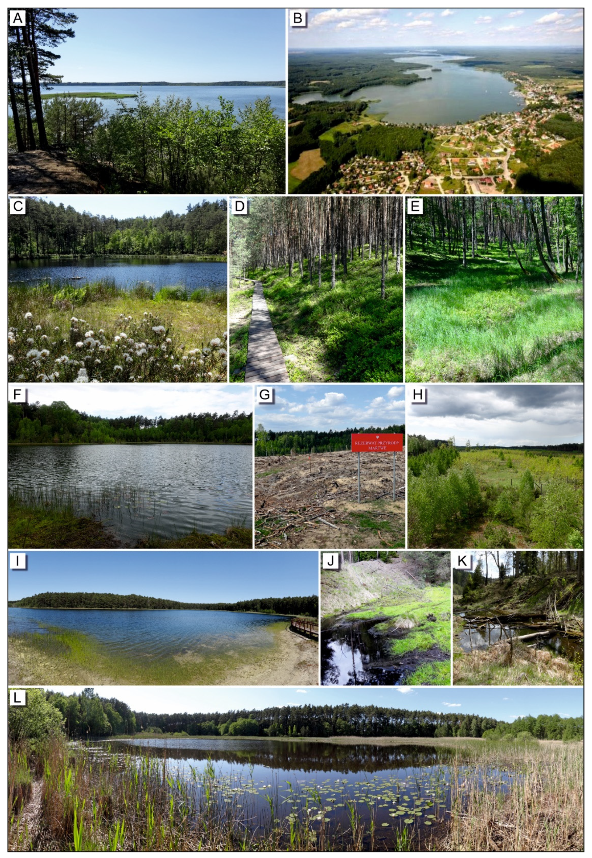
Hydrological and hydrogeological geosites are represented by lakes (5), peatbogs (2), and a spring (1) (Figure 8). The most highly assessed representative of this category is Charzykowskie Lake (no. 25; 42 points—Table 3 and Table 4), situated in the western part of the studied area (Figure 1 and Figure 2). Charzykowskie Lake is a flow-through ribbon lake, having a characteristic longitudinally elongated shape (Figure 8A,B). It has an area of 13.64 km2, which makes it the second largest lake in the Tuchola Forest. Its average depth reaches 9.8 m, whereas the maximum depth is 30.5 m [70]. The lake is characterized by grade II water purity. The genesis of the lake is connected with filling a tunnel valley with dead-ice blocks in the Late Weichselian period (approx. 15,000 years ago) [59], and then with the climate warming, causing the ice to melt. On the north-eastern shores of the lake, the height of which reaches 25 m, a viewing point has been located, which simultaneously is the location of the geosite (Figure 8A). In the nearest neighborhood, there is a very well-developed accommodation and catering base, which is tourist-oriented and focused on water-sports and recreation. The first sailing club in Poland was founded in the nearby village of Charzykowy in 1922.
The basin peatbog Kacze Oko Lake is also remarkable for its high level of geotourist attractiveness (no. 27; 38 points—Table 3 and Table 4). This site represents a group of basin bogs, which are characterized by a small area, which allows them to be perfectly preserved naturally or semi-naturally [71]. The dystrophic Kacze Oko Lake (Figure 8C), covering the area of 0.3 ha and with a maximum depth of 5.4 m, constitutes the water surface of a raised peatbog, which has created a complex of raised peat moss, together with Magellanic peat moss. A typical feature of this site is the accumulation of a several meter-deep layer of detritus gytia, reaching the mineral bedrock formations. The Kacze Oko peatbog has many traces of anthropogenic conversions. The sites bears signs of former exploitation of peat, in the form of resurgent peat trenches [71] (Figure 8E). The geosite has an educational trail, running along a wooden footpath, which enables sightseeing the area without any harm to the ecosystem (Figure 8D).
4.2. Discussion of Value and Spatial Diversification of Geosites in the Area of the Tuchola Forest Biosphere Reserve
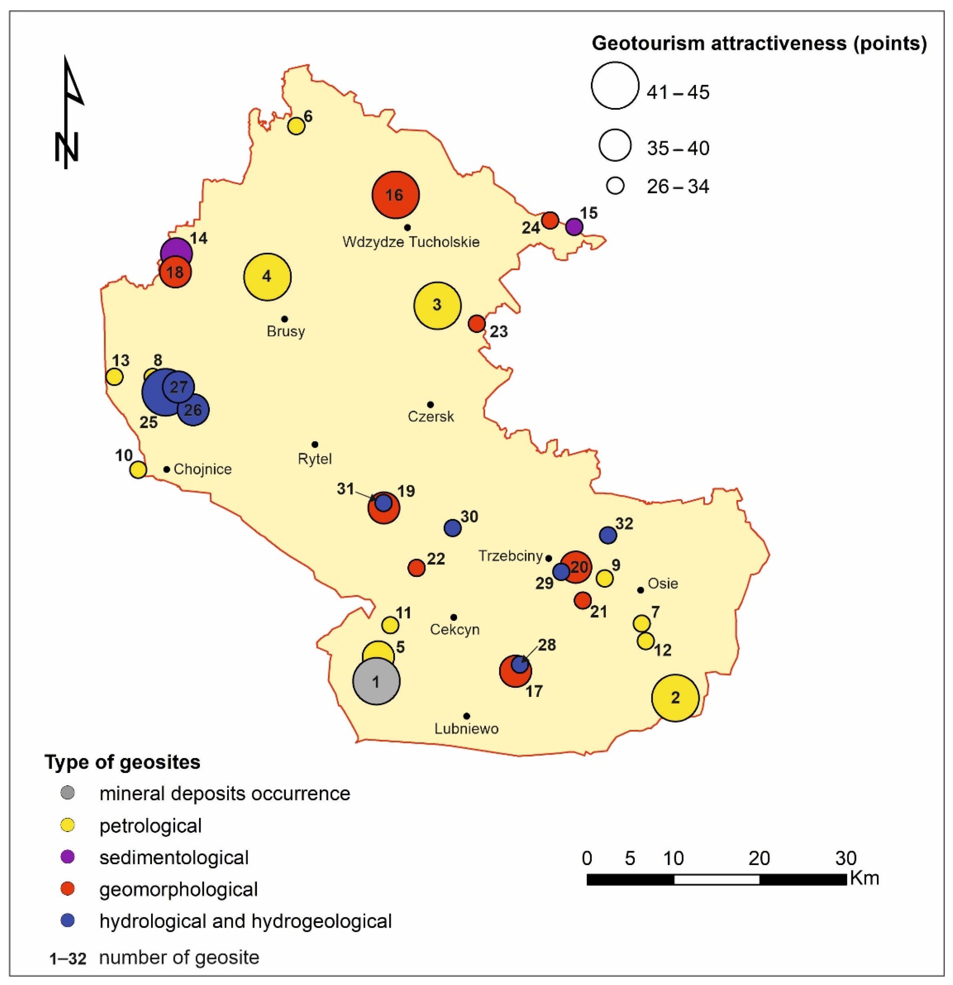
None of the evaluated geosites has received a low score (<21), in terms of geotourist attractiveness. The most attractive geotourist site is a mineral deposit occurrence geosite—a disused lignite mine, called “Montania” in Piła-Młyn—the score of which was 45 points. Apart from this geosite, high scores (between 36 and 44 points) have been received by 13 other geosites (4 petrological geosites, 1 sedimentological geosite, and 5 geomorphological geosites, as well as 3 hydrological and hydrogeological geosites). The highest rated geosites in each group were characterized in Section 4.1. The remaining 18 geosites have received a medium score (Table 3 and Table 4). All the most highly assessed hydrological and hydrogeological geosites (Charzykowskie Lake, no. 25, 42 points; Wielkie Gacno Lake, no. 26, 40 points; and basin peatbog at Kacze Oko Lake, no. 27, 38 points) are concentrated in the area of the Zaborski Landscape Park, while the most highly assessed petrological and geomorphological sites are scattered around the entire TFRB area (Table 3 and Table 4; Figure 3). As far as the most poorly evaluated geosites (<30 points) are concerned, these are mostly sites of the petrological (three geosites), as well as hydrological and hydrogeological (three geosites) types, which is mostly caused by their common occurrence (low level of uniqueness) and insufficient geotourist development (Table 3 and Table 4). Moreover, the most poorly evaluated geosites include one geomorphological site (morainic plateau in the vicinity of Zamek Kiszewski, no. 24, 27 points). Its score is mainly affected by low positioning and low cultural values of the site, as well as bad tourist development (Table 3). The main criteria causing such a large diversity of the geotourist attractiveness of petrological, as well as hydrological and hydrogeological, geosites are the: condition of the site (criterion I/c), size of the site (criterion I/d), esthetic qualities of the site (criterion I/e), uniqueness of the site (criterion I/f), presence or lack of the information board at the site (criterion V/b), and presence or lack of the accompanying equipment (criterion V/c, Table 1).
The evaluation results have also been presented in a spatial form, by means of a map diagram (Figure 3). Such a method of presentation made it possible to indicate places of the highest level of geodiversity and point to those areas where the geosites with the highest score are situated. The evaluated geosites are scattered around the entire research area (Figure 1, Figure 2 and Figure 3). On the whole, three places of high concentration of geosites can be distinguished, and they tend to overlap with the boundaries of landscape parks: the Tuchola Landscape, Wdecki Landscape, and Zaborski Landscape Parks, with the Tuchola Forest National Park. The areas of the greatest diversity of geosites are the Zaborski Landscape and Tuchola Landscape Parks (Figure 1 and Figure 3). Their borders encompass four out of five types of geosites identified in this area. The Zaborski Landscape Park is the area of the greatest concentration of diverse and highly-ranked geosites. They include hydrological and hydrogeological geosites: the Charzykowskie Lake (no. 25; 42 points—Table 3 and Table 4), Wielkie Gacno Lake (no. 26; 40 points), and basin peatbog at Kacze Oko Lake (no. 27, 38 points); petrological geosites: the stone circles in Leśno (no. 4, 41 points), erratic boulder in the village of Małe Swornegacie (no. 8, 32 points), erratic boulder at Wzgórze Wolność (no. 10, 31 points), anderratic boulder in the village of Chociński Młyn (no. 13, 26 points); geomorphological geosites: the Kulawa River Valley (no. 18, 39 points); and sedimentological geosites: natural exposure of lacustrine chalk in the Kulawa River Valley (no. 14, 38 points). The Tuchola Landscape Park includes the following types of geosites: mineral resources occurrence (an absolutely unique site in this part of Poland—exposures of lignite-bearing sediments in disused underground mine “Montania”, no. 1, 45 points), petrological (Piekiełko boulder area, no. 5, 37 points, and Jagiello’s Stone erratic boulder, no. 11), geomorphological (Kozie Lakes postglacial landform, no. 19, 39 points, and viewing point over the Brda River in Gołąbek, no. 22, 33 points), as well as hydrological and hydrogeological (the Stążka River springs, no. 30, 28 points, and Zdręczno lake, no. 31, 26 points). In the Wdecki Landscape Park, there is a large concentration of objects representing three different types of geosites in a relatively small area (petrological—erratic boulder in the township of Tleń, no. 9, 32 points); geomorphological—the Ryszka River Valley, no. 21, 34 points; and hydrological and hydrogeological—Czyściewica spring peatbog, no. 32, 26 points. However, these are geosites of medium geotourist attractiveness (between 27 and 34 points).
Geosites with high intrinsic (>15) and educational value (>26), but low geotourist development value (<4), require improving their accessibility by installation of information boards, benches, and liter bins (criteria V/b and V/c, Table 1). Geosites with a high rate of educational value but low or medium geotourist development value include: the Płociczno (Devil’s Stone), Tleń erratic boulders, late Glacial fossil lake in Bożepole Szlacheckie, the Ryszka River Valley, and Mukrz Lake. The improvement of accessibility of the above mentioned geosites could enhance the geotourist attractiveness of the whole Tuchola Forest region. It points to the necessity of urgently improving geotourist development in these places.
4.3. Impact of External Factors on Changes in Geotourist Attractiveness of Geosites
During the process of geosite evaluation, both the negative and positive impact of extreme weather conditions, such as whirlwinds, on geotourist attractiveness of two geosites was observed.
The petrological geosite erratic boulder Płociczno (Devil’s Stone) (no. 6; Table 3 and Table 4) is located on the north-western edge of the study area (Figure 1 and Figure 2), which suffered the greatest extent of damage, as a result of a whirlwind, which took place at night between 11 and 12 August 2017 [45]. Currently, the forest administration authorities have decided to prevent access to the site until the process of removing fallen trees has come to an end. The educational path with information boards and signposts, which was marked out earlier, has been closed. The consequences of the whirlwind have considerably affected the tourist attractiveness of the geosite by lowering the value of the assessment criteria twice: before and after the disaster of 2017 (Figure 9A–C). The educational value of the geosite has been reduced from 29 points to 23 points (compare values 6 and 6a in Table 3), which results from a lower score given to the current condition of the geosite (criterion I/c, Table 1), positioning in relation to tourist trails (criterion II/b, Table 1), and level of difficulty during sightseeing (criterion II/d, Table 1). The tourist development of the geosite assessment has been negatively affected by the lower score, given for administration and management of the geosite (criterion V/a, Table 1). As a result of this, the assessment value of the geotourist attractiveness of the site has fallen from 34 points before the whirlwind to 26 points after the disaster (Table 2 and Table 3). Additionally, it has been observed that in the Central Register of Polish Geosites by Polish Geological Institute, National Research Institute [59], the information, concerning the condition and accessibility of the geosites, as well as the photographic documentation of the geosites, have not undergone any modifications, which could be regarded as a potential threat to unsuspecting visitors, who do not anticipate any difficulties.
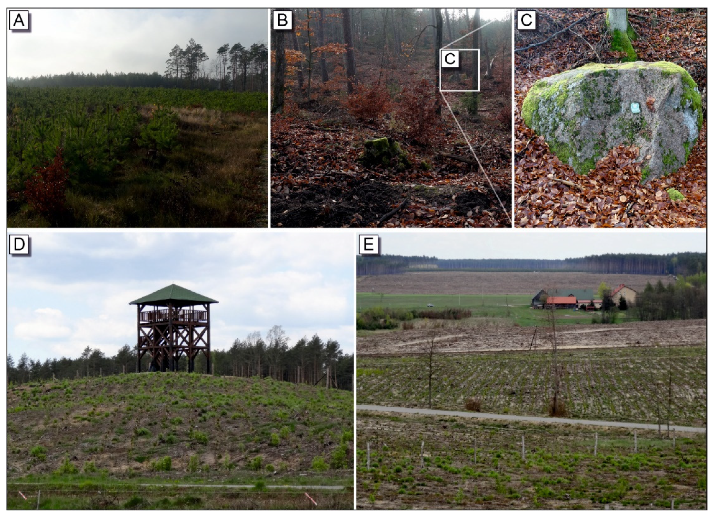
The geomorphological site, referred to as the viewing point near Łążek (no. 20; EV = 27, GA = 36; see Table 3 and Table 4), was created after the whirlwind that swept through the Tuchola Forest on 14 July 2012. The removal of destroyed trees has highlighted the beauty of the landscape; as a result of which, the site has acquired a unique geotourist value. In 2014, an observation tower was erected on the nearby moraine hill (Figure 9D); a year later, an information board and memorial boulder, commemorating the effort of forest workers during the process of cleaning-up the natural debris, were planted. The observation tower offers an excellent view of the outwash plain and Prusina River terrace (Figure 9E). The viewing point clearly demonstrates the scale of destruction of trees and extent of damage (Figure 9D,E).
This observation led us to the conclusion that the condition of geosites requires permanent geomonitoring (site condition monitoring) or episodic monitoring after each significant, extreme weather event, as a tool of geoconservation and geoheritage management, cf. [72].
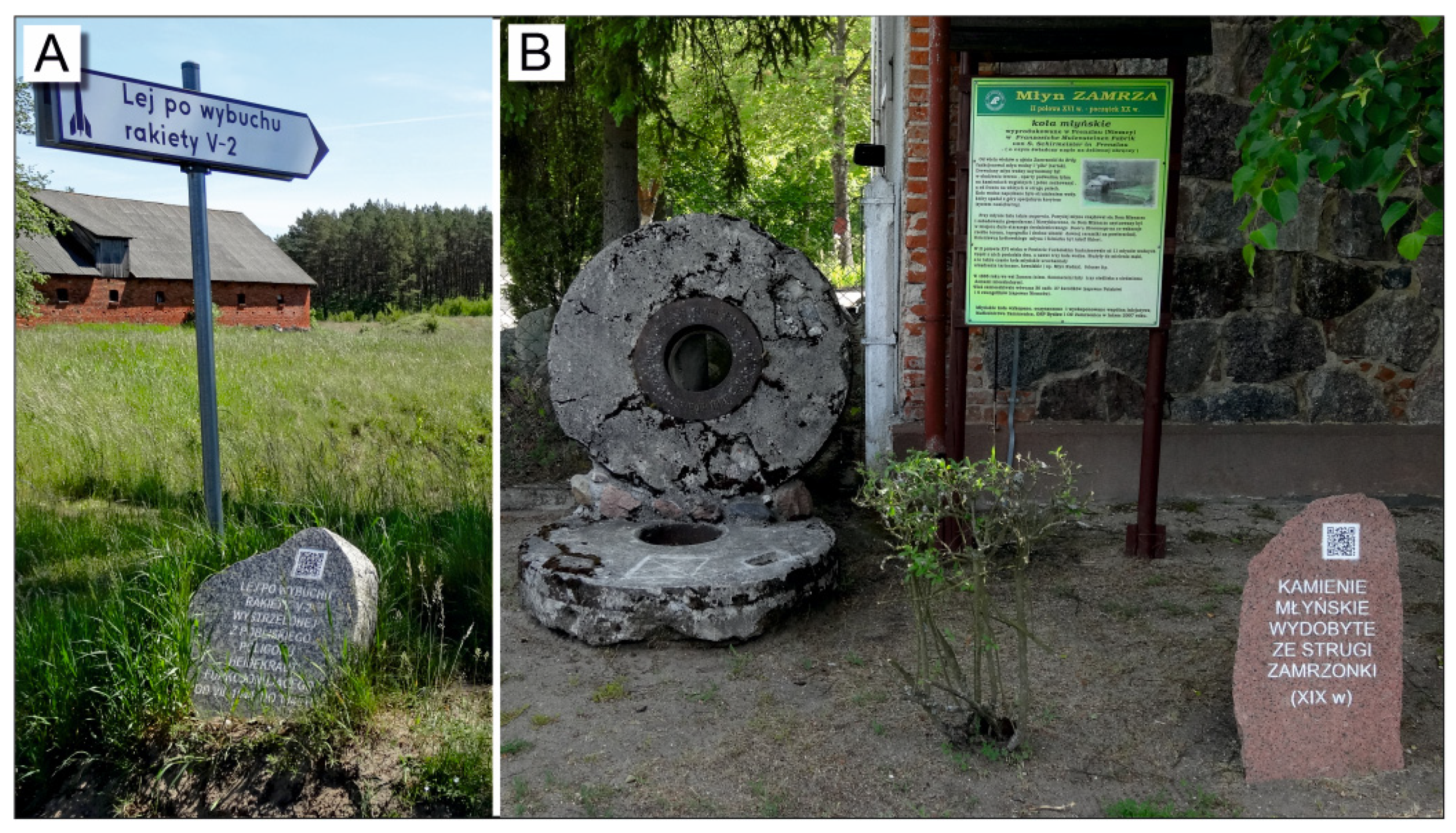
4.4. “Speaking Stones”—Form of Communicating Tourist Information Which Enhances Geotourist Attractiveness
In recent years, in the Tuchola district, which, as an administrative unit, occupies 26% of the total area of the TFBR, located in its very centre, a new innovative form of communicating tourist information has been introduced. Commonly occurring erratic boulders have been used as information storage media (Figure 10A,B). Each of 150 boulders, the height of which does not exceed 1 m, contains short information about the site engraved on it, as well as a QR code, which enables acquiring more information about the geosite on a mobile device. The system of the so-called “speaking stones” was created as a part of the project referred to as “Borowieckie Trails”, the purpose of which was to revitalize 540 km of tourist trails in the Tuchola Forest and create a tourist website and mobile e-guide around tourist attractions of the Tuchola district [73]. In the case of a few analysed geosites, the presence of “speaking stones” has favorably affected the assessment of the following criteria: scope of information about the site, accessibility of the geosites, and geotourist development (criteria IV and V; Table 1). This observation is a good example of the possible positive human-induced impact on geoheritage, cf. [72].
4.5. Importance of the Study and Recommendations
The area of TFBR was assessed to be on the early (development) phase of Stansfield-Butler tourist area cycle of evolution, which means that the present pressure of tourism on the environment is low but expected to increase in the near future, with an increasing number of tourists visiting [74,75]. Simultaneously, the quality of sustainable tourism implementation level in the study area was evaluated as a low [74]. In this context, it is believed that the results of conducted evaluation may favorably affect the importance, position, and publicity of the whole TFBR by supplementing the well-recognized biodiversity with geodiversity, presented in the study. Moreover, the authors claim that the results of the study may be used as an inventory for the process of the establishing geoconservation protected areas and geoheritage management in the area of TFBR, cf. [72]. We also recognize the necessity of marking out geotourist trails in the most attractive and diversified areas (for example, in the areas of Zaborski and Wdecki Landscape Parks, where several attractive geosites are concentrated in a relatively small area with good communication infrastructure).
The authors of the study recommend entering nine geosites, which have been described in the study, into the Central Register of Polish Geosites by Polish Geological Institute, National Research Institute, as so far, they have gone unrecognized (Table 4).
5. Conclusions
- In the area of the Tuchola Forest Biosphere Reserve (TFBR), which is distinguished by its biodiversity, numerous and diverse valuable geosites of inanimate nature can be found;
- The evaluation of 32 sites has been carried out, among which mineral deposits occurrence (1), petrological (12), sedimentological (2), and geomorphological (9), as well as hydrological and hydrogeological (8). Geosites represent both perfect examples of typical features for the physiography of the TFBR as a young glacial area (for instance, kettle holes, outwash plains, tunnel valleys, erratic boulders, lakes, and peatbogs) and values proving the uniqueness of the TFBR, on both the regional and international scales (for example, disused underground lignite mine “Montania” or stone circle reserve in Odry);
- There are three areas of high concentration of geosites that overlap with the boundaries of landscape parks: Tuchola Landscape, Wdecki Landscape, Zaborski Landscape Parks. The area of the greatest diversity of highly-ranked geosites is Zaborski Landscape Park;
- The most highly assessed geosite is the disused lignite mine “Montania”. This site has scored 45 points for its geotourist attractiveness. The site, in Piła-Młyn, where lignite-bearing sediments are exposed, is a unique monument of underground lignite mining in northern Poland. The high intrinsic value of the geosite is supplemented by very good geotourist development;
- Some of the geosites have changed their geosite attractiveness, as a result of extreme weather phenomena. Thus, the condition of geosites requires the introduction of geomonitoring, as a tool of geoconservation and geoheritage management.
Author Contributions
Conceptualization, A.K. and W.W.; methodology, A.K., W.W. and I.J.; GIS analysis, I.J. and W.W.; field trips, W.W., S.B., A.K. and I.J.; archive resources and literature: W.W.; writing—original draft preparation, W.W.; S.B., I.J. and A.K.; writing—review and editing, S.B., I.J. and A.K.; figures, W.W., S.B. and I.J. All authors have read and agreed to the published version of the manuscript.
Funding
Research has been partially financed from the grant for young academic faculty and doctoral students of Faculty of Earth Sciences and Spatial Management, Nicolaus Copernicus University (S. Belzyt).
Institutional Review Board Statement
Not applicable.
Informed Consent Statement
Not applicable.
Data Availability Statement
All data are available from the corresponding author upon reasonable request.
Acknowledgments
The authors thank the anonymous reviewers for their constructive comments that helped improve the manuscript.
Conflicts of Interest
The authors declare no conflict of interest. The funders had no role in the design of the study; in the collection, analyses, or interpretation of data; in the writing of the manuscript, or in the decision to publish the results.
References
- Boiński, M. Rezerwat Biosfery “Bory Tucholskie”. In Proceedings of the Bory Tucholskie: Walory Przyrodnicze, Problemy Ochrony, Przyszłość, Bachorze, Poland, 17–20 September 1992; Nicolaus Copernicus University: Toruń, Poland, 1993; pp. 361–375. [Google Scholar]
- Boiński, M.; Boińska, U. Interesting plant species and communities of Wdecki Landscape Park and its environs. In Rola i Funkcjonowanie Parków Krajobrazowych w Rezerwatach Biosfery; Kunz, M., Ed.; Wydawnictwo UMK: Toruń, Poland, 2020; pp. 247–270. [Google Scholar]
- Grzempa, M.; Kowalewski, G.; Kunz, M.; Rymon Lipińska, J. Rezerwat Biosfery Bory Tucholskie; Pomorski Zespół Parków Krajobrazowych: Charzykowy, Poland, 2014; pp. 1–39. [Google Scholar]
- Nienartowicz, A.; Domin, D.J.; Kunz, M.; Przystalski, A. Biosphere Reserve Tuchola Forest. Nomination form; Sandry Brdy: Chojnice, Poland, 2010. [Google Scholar]
- Najwer, A.; Zwoliński, Z. Semantyka i metodyka oceny georóżnorodności—Przegląd i propozycja badawcza. Landf. Anal. 2014, 26, 115–127. [Google Scholar] [CrossRef]
- Weidenbein, F.W. Ein Geotopschutzkonzept für Deutschland. In Proceedings of the Geotopschutz Probleme: Der Methodik und der Praktischen, Saarbrucken, Germany, 10–17 September 1995; University of Saarland: Saarbrucken, Germany, 1993; p. 56. [Google Scholar]
- Sharples, C. A Methodology for the Identification of Significant Landforms and Geological Sites for Geoconservation Purposes; Forestry Commission Tasmania: Tasmania, Australia, 1993. [Google Scholar]
- Gray, M. Geodiversity: Valuing and Conserving Abiotic Nature, 2nd ed.; Wiley-Blackwell: Hoboken, NJ, USA, 2013. [Google Scholar]
- Sharples, C. Geoconservation in forest management—Principles and procedures. Tasforests 1995, 7, 37–50. [Google Scholar]
- Kiernan, K. An Atlas of Tasmanian Karst: Volumes 1–2 Research Report No. 10; Tasmanian Forest Research Council Inc.: Tasmania, Australia, 1995. [Google Scholar]
- Kiernan, K. Conserving Geodiversity and Geoheritage: The Conservation of Glacial Landforms; Forest Practices Unit: Hobart, Australia, 1996. [Google Scholar]
- Dixon, G. Geoconservation: An International Review and Strategy for Tasmania. Ocasional Paper 35; Parks and Wildlife Service: Tasmania, Australia, 1996. [Google Scholar]
- Eberhard, R. Pattern & Process: Towards a Regional Approach for National Estate Assessment of Geodiversity; Environment Australia: Canberra, Australia, 1997. [Google Scholar]
- Pellitero, R.; Manosso, F.C.; Serrano, E. Mid- and Large-Scale Geodiversity Calculation in Fuentes Carrionas (NW Spain) and Serra do Cadeado (Paraná, Brazil): Methodology and Application for Land Management. Geogr. Ann. Ser. A Phys. Geogr. 2015, 97, 219–235. [Google Scholar] [CrossRef]
- Gray, M. Geodiversity: Valuing and Conserving Abiotic Nature, 1st ed.; John Wiley and Sons: Chichester, UK, 2004. [Google Scholar]
- Gray, M. Geodiversity: The origin and evolution of a paradigm. In The History of Geoconservation; Special Publication 300; Geological Society of London: London, UK, 2008; pp. 31–36. [Google Scholar]
- Zwoliński, Z. The routine of landform geodiversity map design for the Polish Carpathian Mts. Landf. Anal. 2009, 11, 77–85. [Google Scholar]
- Miśkiewicz, K. Problemy badawcze georóżnorodności w geoturystyce. Geoturystyka 2009, 1–2, 3–12. [Google Scholar]
- Serrano, E.; Ruiz-Flaño, P. Geodiversity: A theoretical and applied concept. Geogr. Helv. 2007, 62, 140–147. [Google Scholar] [CrossRef]
- Serrano, E.; Ruiz-Flaño, P.; Arroyo, P. Geodiversity assessment in a rural landscape: Tiermes-Caracena area (Soria, Spain). Mem. Descr. Cart. Geol. d’It. 2009, 87, 173–179. [Google Scholar]
- Hjort, J.; Luoto, M. Geodiversity of high-latitude landscapes in northern Finland. Geomorphology 2010, 115, 109–116. [Google Scholar] [CrossRef]
- Pellitero, R.; González-Amuchastegui, M.J.; Ruiz-Flaño, P.; Serrano, E. Geodiversity and geomorphosite assessment applied to a natural protected area: The ebro and rudron gorges natural park (spain). Geoheritage 2010, 3, 163–174. [Google Scholar] [CrossRef]
- Comanescu, L.; Nedelea, A. The assessment of geodiversity—A premise for declaring the geopark Buzǎului County (Romania). J. Earth Syst. Sci. 2012, 121, 1493–1500. [Google Scholar] [CrossRef] [Green Version]
- Kot, R. Zastosowanie indeksu georóżnorodności dla określenia zróżnicowania rzeźby terenu na przykładzie zlewni reprezentatywnej Strugi Toruńskiej, Pojezierze Chełmińskie (Application of the geodiversity index for defining the relief’s diversity based on the examp. Probl. Ekol. Kraj. 2012, 33, 87–96. [Google Scholar]
- Brilha, J.; Gray, M.; Pereira, D.I.; Pereira, P. Geodiversity: An integrative review as a contribution to the sustainable management of the whole of nature. Environ. Sci. Policy 2018, 86, 19–28. [Google Scholar] [CrossRef] [Green Version]
- Kozłowski, S. Geodiversity. The concept and scope of geodiversity. Prz. Geol. 2004, 52, 833–837. [Google Scholar]
- Zwoliński, Z.; Najwer, A.; Giardino, M. Methods for assessing geodiversity. In Geoheritage: Assessment, Protection, and Management; Reynard, E., Brilha, J., Eds.; Elsevier: Amsterdam, The Netherlands, 2018; pp. 27–53. [Google Scholar]
- Urban, J.; Migoń, P.; Radwanek-Bąk, B. Dziedzictwo geologiczne. Przegląd Geol. 2021, 69, 16–20. [Google Scholar] [CrossRef]
- Alexandrowicz, Z. Sandstone rocky forms in Polish Carpathians attractive for education and tourism. Prz. Geol. 2008, 56, 680–687. [Google Scholar]
- Alexandrowicz, Z.; Alexandrowicz, W.P.; Buczek, K. Conservation of the Natura 2000 Areas in the Context of Environmental Changes in Past and Present: A Case from the Polish Carpathians Geoheritage. Geoheritage 2019, 11, 517–529. [Google Scholar] [CrossRef] [Green Version]
- Alexandrowicz, Z.; Poprawa, D.; Ra̧czkowski, W. The regional network of geosites in the Polish Carpathians. Prz. Geol. 1998, 46, 775–781. [Google Scholar]
- Migoń, P.; Sobczyk, A. Opracowanie metodyki waloryzacji i waloryzacja geostanowisk Karkonoskiego Parku Narodowego i jego otuliny. In Inwentaryzacja i Waloryzacja Geostanowisk Karkonoskiego Parku Narodowego i Jego Otuliny Oraz Wykonanie Mapy Geologicznej Tego Obszaru; Ministerstwo Środowiska: Warszawa, Poland, 2010; pp. 5–16. [Google Scholar]
- Migoń, P.; Pijet-Migoń, E. Overlooked Geomorphological Component of Volcanic Geoheritage—Diversity and Perspectives for Tourism Industry, Pogórze Kaczawskie Region, SW Poland. Geoheritage 2016, 8, 333–350. [Google Scholar] [CrossRef]
- Urban, J.; Gągol, J. Geological heritage of the Świetokrzyskie (Holy Cross) mountains (Central Poland). Prz. Geol. 2008, 56, 618–628. [Google Scholar]
- Zwolinski, Z. Aspekty turystyczne georóżnorodności rzeźby Karpat. Pr. Kom. Kraj. Kult. PTG 2010, 14, 316–327. [Google Scholar]
- Skibiński, J.; Kultys, K.; Baran-Zgłobicka, B.; Zgłobicki, W. Geoparks in SE Poland as areas of tourism development: Current state and future prospects. Resources 2021, 10, 113. [Google Scholar] [CrossRef]
- Jamorska, I.; Sobiech, M.; Karasiewicz, T.; Tylmann, K. Geoheritage of Postglacial Areas in Northern Poland—Prospects for Geotourism. Geoheritage 2020, 12, 12. [Google Scholar] [CrossRef] [Green Version]
- Nizicka, D.; Pochocka-Szwarc, K.; Ber, A. Geotourism in the Suwałki Landscape Park. Prz. Geol. 2008, 56, 614–617. [Google Scholar]
- Graniczny, M.; Kowalski, Z.; Czarnogórska, M.; Krzeczyńska, M.; Pupienis, D.; Satkunas, J. Projected Geopark Yotvings—Polish-Lithuanian cross border area. Prz. Geol. 2008, 56, 611–613. [Google Scholar]
- Zwoliński, Z.; Hildebrandt-Radke, I.; Mazurek, M.; Makohonienko, M. Existing and Proposed Urban Geosites Values Resulting from Geodiversity of Poznań City. Quaest. Geogr. 2017, 36, 125–149. [Google Scholar] [CrossRef] [Green Version]
- Kozłowska-Adamczak, M.; Krupa, A. Projekt koncepcji geoparku o randze lokalnej pod nazwą “Krajna—Polodowcowa Kraina Ozów”, jako produkt finalny opracowania Strategii Rozwoju Turystyki Lokalnej Grupy Działania Stowarzyszenia “Nasza Krajna”—raport z badań przeprowadzonych w latach 2011. J. Health Sci. 2013, 3, 25–34. [Google Scholar]
- Kamieńska, K.; Giemza, A. Inwentaryzacja geostanowisk w projektowanym Geoparku “Polodowcowa Kraina Drawy i Dębnicy”. Przegląd Geol. 2014, 62, 15–22. [Google Scholar]
- Nienartowicz, A.; Kunz, M. 10 lat funkcjonowania Rezerwatu Biosfery Bory Tucholskie. In Rola i Funkcjonowanie Parków Krajobrazowych w Rezerwatach Biosfery; Kunz, M., Ed.; Wydawnictwo UMK: Toruń, Poland, 2020; pp. 13–38. [Google Scholar]
- Nienartowicz, A.; Kunz, M. Tuchola Forest Biosphere Reserve 2.0—The Grounds and the Scope of the Proposed Changes; Lokalna Grupa Działania Sandr Brdy: Chojnice, Poland, 2018. [Google Scholar]
- Chojnacka-Ożga, L.; Ożga, W. Meteorological Conditions of the Occurrence of Wind Damage on August 11−12, 2017 in the Forests of Central−Western Poland. Sylwan 2018, 162, 200–208. [Google Scholar]
- Chojnacka-Ożga, L.; Ożga, W. Silne wiatry jako przyczyna zjawisk klęskowych w lasach. Studia Mater. Cent. Edukac. Przyr. Leśnej 2017, 20, 13–23. [Google Scholar]
- Kistowski, M. Regionalizacja fizycznogeograficzna Rezerwatu Biosfery Bory Tucholskie w świetle aktualnych doświadczeń badawczych. In Rola i Funkcjonowanie Parków Krajobrazowych w Rezerwatach Biosfery; Kunz, M., Ed.; Wydawnictwo UMK: Toruń, Poland, 2020; pp. 39–60. [Google Scholar]
- Solon, J.; Borzyszkowski, J.; Bidłasik, M.; Richling, A.; Badora, K.; Balon, J.; Brzezińska-Wójcik, T.; Chabudziński, Ł.; Dobrowolski, R.; Grzegorczyk, I.; et al. Physico-geographical mesoregions of poland: Verification and adjustment of boundaries. Geogr. Pol. 2018, 91, 143–170. [Google Scholar] [CrossRef]
- Kondracki, J. Geografia Regionalna Polski, 3rd ed.; PWN: Warszawa, Poland, 2009. [Google Scholar]
- Umiński, J. Bory Tucholskie; Krajowa Agencja Wydawnicza: Warszawa, Poland, 1980. [Google Scholar]
- Boiński, M. Zróżnicowanie szaty roślinnej Borów Tucholskich. Echo Borów Tucholskich 2001, 1, 28–29. [Google Scholar]
- Żelaźniewicz, A.; Aleksandrowski, P.; Buła, Z.; Karnkowski, P.H.; Konon, A.; Oszczypko, N.; Ślączka, A.; Żaba, J.; Żytko, K. Regionalizacja Tektoniczna Polski; Komitet Badań Geologicznych PAN: Wrocław, Poland, 2011. [Google Scholar]
- Karasiewicz, T.; Weckwerth, P.; Adamczyk, A.; Redzimska, B. Budowa geologiczna i geomorfologia Tucholskiego Parku Krajobrazowego. In Stan Poznania Środowiska Przyrodniczego Tucholskiego Parku Krajobrazowego i Rezerwatu Biosfery Bory Tucholskie; Kunz, M., Ed.; Polskie Wydawnictwa Reklamowe: Toruń, Poland, 2015; pp. 15–30. [Google Scholar]
- Krawiec, A.; Labak-Mechowska, E. Wody podziemne Tucholskiego Parku Krajobrazowego. In Stan Poznania Środowiska Przyrodniczego Tucholskiego Parku Krajobrazowego i Rezerwatu Biosfery Bory Tucholskie; Kunz, M., Ed.; Polskie Wydawnictwa Reklamowe: Toruń, Poland, 2015; pp. 68–79. [Google Scholar]
- Liberacki, M. Formy wytopiskowe na obszarze sandru i doliny Brdy. Zesz. Nauk. Uniw. Mikołaja Kopernika W Tor. Geogr. 1959, 4, 49–70. [Google Scholar]
- Karasiewicz, T.M. The kettle-hole mire as archives of postglacial changes in biogenic sedimentation (Tuchola Forest, north-Central Poland). Catena 2019, 176, 26–44. [Google Scholar] [CrossRef]
- Adamczyk, A.; Wysota, W.; Sobiech, M. A morphometric analysis of an exceptionally long and complex tunnel valley: A case study of the Byszewo Landform, NW Poland. Z. Geomorphol. 2017, 61, 27–44. [Google Scholar] [CrossRef]
- Marks, L. Geological Map of Poland 1: 500-000 with Explanatory Text; Państwowy Instytut Geologiczny: Warszawa, Poland, 2015. [Google Scholar]
- Central Register of Polish Geosites by Polish Geological Institute—National Research Institute. Available online: https://cbdgportal.pgi.gov.pl/geostanowiska/ (accessed on 15 December 2021).
- Dmytrowski, P.; Kicińska, A. Waloryzacja geoturystyczna obiektów przyrody nieożywionej i jej znaczenie w perspektywie rozwoju geoparków. Probl. Ekol. Kraj. 2011, 29, 11–20. [Google Scholar]
- Miśkiewicz, K.; Stadnik, R.; Waśkowska-Oliwa, A. Geodiversity of the Gościbia Stream valley as a geotouristic attraction of the Flysch Carpathians. In Proceedings of the GEOTOUR 2008: Geotourism and Minning Heritage, 4th International Conference, Kraków, Poland, 26–28 June 2008; Słomka, T., Ed.; Wydawnictwo AGH: Kraków, Poland, 2008; pp. 41–42. [Google Scholar]
- Alexandrowicz, Z.; Kućmierz, A.; Urban, J.; Otęska-Budzyń, J. Waloryzacja Przyrody Nieożywionej Obszarów i Obiektów Chronionych w Polsce. In Evaluation of Inanimate Nature of Protected Areas and Objects in Poland; Polish Geological Institute: Warszawa, Poland, 1992. [Google Scholar]
- Kicińska-Świderska, A.; Słomka, T. Projektowanie tras geoturystycznych. Folia Tur. 2004, 15, 179–184. [Google Scholar]
- Kotyrba, A.; Frolik, A.; Kortas, Ł.; Siwek, S. Zagrożenia pogórnicze na terenach dawnych podziemnych kopalń węgla brunatnego w rejonie Piły-Młyna (województwo kujawsko-pomorskie). Przegląd Górniczy 2012, 68, 58–66. [Google Scholar]
- Kiszka, J.; Lipnicki, L. Wstępne uwagi o wynikach badań lichenoflory głazów narzutowych w rezerwacie “Kręgi Kamienne”. In Proceedings of the Bory Tucholskie: Walory Przyrodnicze, Problemy Ochrony, Przyszłość, Bachorze, Poland, 17–20 September 1992; Rejewski, M., Nienartowicz, A., Boiński, M., Eds.; Uniwersytet Mikołaja Kopernika: Toruń, Poland, 1993; pp. 108–110. [Google Scholar]
- Błaszkiewicz, M.; Krzymińska, J. Ewolucja późnoglacjalnego jeziora w depresji końcowej. In Proceedings of the Rozwój i Zanik Lądolodu Fazy Pomorskiej Zlodowacenia Wisły na Pomorzu Wschodnim (Kociewie). XVIII Konferencja Naukowo-Szkoleniowa Stratygrafia Plejstocenu Polski, Stara Kiszewa, Poland, 5–9 September 2011; Kordowski, J., Lamparski, P., Pochocka-Szwarc, K., Eds.; Polish Geological Institute: Warszawa, Poland, 2011; pp. 134–140. [Google Scholar]
- Karasiewicz, T.; Gromek, P. Morfogeneza Obszaru Rezerwatu “Cisy Staropolskie im. L. Wyczółkowskiego” w Wierzchlesie i jego najbliższego otoczenia. In Rezerwat Przyrody “Cisy Staropolskie im. Leona Wyczółkowskiego” w Wierzchlesie; Pająkowski, J., Ed.; Zespół Parków Krajobrazowych Chełmińskiego i Nadwiślańskiego i Towarzystwo Przyjaciół Dolnej Wisły: Świecie, Poland, 2011; pp. 34–43. [Google Scholar]
- Słowański, W. Wczesnoholoceńskie osady jeziorne w Lasce koło Brus. Kwart. Geol. 1961, 5, 719–737. [Google Scholar]
- Błaszkiewicz, M. Późnoglacjalna i Wczesnoholoceńska Ewolucja Obniżeń Jeziornych na Pojezierzu Kociewskim (Wschodnia część Pomorza); Prace Geog.; Polska Akademia Nauk, Instytut Geografii i Przestrzennego Zagospodarowania: Warszawa, Poland, 2005. [Google Scholar]
- Choiński, A. Katalog Jezior Polski; Wydawnictwo Naukowe UAM: Poznań, Poland, 2013. [Google Scholar]
- Tobolski, K. Torfowiska Parku Narodowego Bory Tucholskie; Park Narodowy Bory Tucholskie: Charzykowy, Poland, 2006. [Google Scholar]
- Crofts, R.; Gordon, J.E.; Brilha, J.; Gray, M.; Gunn, J.; Lawood, J.; Santucci, V.L.; Tormey, D.; Worboys, G.L. Guidelines for GEOCONSERVATION in Protected and Conserved Areas; IUCN: Gland, Switzerland, 2020. [Google Scholar]
- Website of the Tuchola County. Available online: www.tucholski.pl (accessed on 15 December 2021).
- Kistowski, M.; Kowalczyk, J. Rozwój turystyki w wybranych parkach krajobrazowych Polski w świetle koncepcji cyklu ewolucji obszarów turystycznych. Probl. Ekol. Kraj. 2013, 34, 77–85. [Google Scholar]
- Butler, R.W. The Concept of a Tourist Area Cycle of Evolution: Implications for Management of Resources Change on a remote island over half a century View project. Can. Geogr. 1980, 24, 5–12. [Google Scholar] [CrossRef]
Figure 1.
Study area—Tuchola Forest Biosphere Reserve (TFBR), with the locations of national parks, landscape parks, and geosites. Base layers: OpenStreetMap; Corine Land Cover; Digital Elevation Model—www.geoportal.gov.pl (accessed on 20 December 2021).
Figure 1.
Study area—Tuchola Forest Biosphere Reserve (TFBR), with the locations of national parks, landscape parks, and geosites. Base layers: OpenStreetMap; Corine Land Cover; Digital Elevation Model—www.geoportal.gov.pl (accessed on 20 December 2021).

Figure 2.
Geological map of the study area (after geological map of Poland, in scale 1:500,000 [58]; changed) and location of geosites. Base layers: OpenStreetMap; digital elevation model—www.geoportal.gov.pl (accessed on 20 December 2021).
Figure 2.
Geological map of the study area (after geological map of Poland, in scale 1:500,000 [58]; changed) and location of geosites. Base layers: OpenStreetMap; digital elevation model—www.geoportal.gov.pl (accessed on 20 December 2021).

Figure 3.
Map diagram showing the spatial diversification of geosites in the area of the Tuchola Forest Biosphere Reserve.
Figure 3.
Map diagram showing the spatial diversification of geosites in the area of the Tuchola Forest Biosphere Reserve.

Figure 4.
A sample geosite documentation card of a disused underground lignite mine “Montania” in Piła-Młyn, no. 1—the geosite with the highest score, in terms of geotourist attractiveness, in the area of the Tuchola Forest Biosphere Reserve (photo by: W. Wysocki and A. Krawiec).
Figure 4.
A sample geosite documentation card of a disused underground lignite mine “Montania” in Piła-Młyn, no. 1—the geosite with the highest score, in terms of geotourist attractiveness, in the area of the Tuchola Forest Biosphere Reserve (photo by: W. Wysocki and A. Krawiec).

Figure 5.
The disused lignite mine “Montania” in Piła-Młyn, no. 1—the geosite with the highest score, in terms of geotourist attractiveness in the area of the Tuchola Forest Biosphere Reserve. (A) entrance to the old shaft and old mining equipment; (B) original entrance to the shaft; (C) exhibition of renovated mining equipment; (D) entrance to the “Mining Village”; (E) example of information boards installed in the “Mining Village”; (F) interactive model of the former mining town (photo by: A. Krawiec and S. Belzyt).

Figure 6.
Examples of geosites typical for young glacial landscape. Petrological geosites: (A,B) St. Wojciech’s (St. Adalbert’s) Stone, no. 2; (C) erratic boulder in the village of Żur, no. 7; (D) erratic boulder at the Wzgórze Wolność, no. 10; (E,F) erratic boulders in stone circle reserve in Odry, arranged in stone circles (megalithic structure), no. 3; (G) Piekiełko boulder area—erratic boulders located along the riverbank in the river gap section of the Brda River, no. 5; sedimentological geosite: (H) natural exposure of Late Glacial fossil lake in Bożepole Szlacheckie, no. 15 (photo by: A. Krawiec, W. Wysocki and S. Belzyt).

Figure 7.
Examples of geomorphological geosites typical for young glacial landscape. (A) Wdzydzkie Lakes Cross site—the observation tower over Wdzydze Lake, no. 16; (B) fragment of the panorama view from the top of observation tower in Wdzydze Kiszewskie, no. 14—intersection of two tunnel valleys, filled with water from Wdzydze and Jelenie Lakes; (C) information boards installed by the Wdzydzki Landscape Park authorities; (D) fragment of a slope of kame in Wierzchlas Reserve, no. 17; (E) former kettle hole, currently almost totally overgrown with peat vegetation in Wierzchlas Reserve, no. 17; (F) viewing point over the meandering Brda River Valley in Gołąbek, no. 22 (photo by: S. Belzyt and W. Wysocki); (G) contact of the tunnel valley, in the vicinity of Wiecko, with the erosive part of Wda River valley, no. 23 (interpretation after Błaszkiewicz, 2005 [69]). Base layer: digital elevation model—www.geoportal.gov.pl (accessed on 20 December 2021).

Figure 8.
Examples of hydrological and hydrogeological geosites. (A) View point on the north-eastern shores of the Charzykowskie Lake, no. 25; (B) aerial view of the south-eastern shores of the Charzykowskie Lake, no. 25; (C) view of the Kacze Oko Lake basin peatbog, no. 27; (D) educational trail, along the kettle-hole in Kacze Oko Lake basin peatbog geosite, no. 27; (E) traces of former exploitation of peat in Kacze Oko Lake basin peatbog geosite, no. 27; (F) view on the dystrophic Martwe Lake, no. 29; (G) trees destroyed by whirlwind, which swept through the area on 14 July 2012, in the closest vicinity of the Martwe Lake geosite (no. 29)—the comparison of views on the exposed southern part of the kettle-hole in years 2014 and (H) 2021; (I) inland lobelia lake Wielkie Gacno, no. 26; (J) Czyściewnica spring complex peatbog, no. 32, and (K) a part of the longest beaver dam in TFBR (50 m long); (L) eutrophic part of the Zdręczno Lake, surrounded by a highmoor peatland, no. 31 (photo A and C–L by: W. Wysocki, A. Krawiec and S. Belzyt; photo B, courtesy of the Promotion of the Chojnice Region Organization—www.turystyka-chojnice.pl (accessed on 15 September 2021)).

Figure 9.
Impact of extreme weather phenomena on changes in geotourist attractiveness of geosites. (A–C) The destroyed trees and current availability of the petrological site Płociczno erratic boulder (Devil’s Stone), no. 6, after a whirlwind that took place at night, between 11 and 12 August 2017; (D) geomorphological site viewing point near Łążek, no. 20, that was created on the area affected by a whirlwind that took place on 14 July 2012; (E) view of the outwash plain and the Prusina River terrace from the observation tower—viewing point near Łążek, no. 20 (photo by: S. Belzyt and W. Wysocki).

Figure 10.
Examples of the “speaking stones”—form of communicating tourist information that enhances geotourist attractiveness of the sites. (A) Cultural site—crater after the explosion of a V-2 missile; (B) archaeological and cultural site—millstones extracted from the Zamrzonka River (photo by: W. Wysocki).


Table 1.
Basic values, assessment criteria, and scores of geotourist evaluation of the geosites in Tuchola Forest Biosphere Reserve, on the basis of Dmytrowski and Kicińska [60], with modifications by the authors.
Table 1.
Basic values, assessment criteria, and scores of geotourist evaluation of the geosites in Tuchola Forest Biosphere Reserve, on the basis of Dmytrowski and Kicińska [60], with modifications by the authors.
| No. | Criterion | High Score (3 Points) | Medium Score (2 Points) | Low Score (1 Point) |
|---|---|---|---|---|
| I—intrinsic value of the site | ||||
| I/a | significance of the site, in the context of geology and geomorphology of the region (the rank of the site) | high the site well describes the formation of the region and all the processes happening | medium the site partially describes the formation of the region | low the site of little or no significance to the formation of the region |
| I/b | geological and geomorphological value of the site | high complex structure or very well visible geological or geomorphological processes | medium partly visible monothematic structure or geomorphology | low poorly visible or invisible geological or geomorphological structure |
| I/c | condition of the site | high the site in a very good condition, not overgrown with vegetation or littered | medium the site partly overgrown with vegetation or partly littered | low the site in a very bad condition, virtually invisible, due to being totally overgrown with vegetation or extremely littered |
| I/d | the size of the site (relevant to the type of the site) | high outstanding in terms of size | medium of average size | low rather insignificant in terms of size |
| I/e | esthetic qualities of the site | high the site located in excellent visibility with its structure drawing attention | medium the site only partially visible with its structure of rather average attractiveness | low the site indistinguishable from the surrounding scenery, not drawing any attention |
| I/f | uniqueness of the site | high the site is the only example occurring in the region | medium the site is one of few specimens of this type in the region | low the site is one of many specimens of this type in the region |
| I/g | thematic variations of the sites | high the site represents more than 3 different themes | medium the site represents between 2 and 3 different themes | low the site represents less than 2 themes |
| II—the positioning value of the site | ||||
| II/a | location in relation to main communication routes | good location of the site within 1 km from a communication route with a parking | average location of the site within 1–3 km from a communication route | bad location of the site within a distance longer than 3 km from a communication route |
| II/b | location in relation to main tourist trails (cycling, walking, and others) | good location of the site within 0–10 m from a tourist trail | average location of the site within 10–200 m from a tourist trail | bad location of the site within a distance longer than 200 m from a tourist trail |
| II/c | location in relation to main tourist centers | good location of the site on the premises of a tourist centre or on its periphery | average location of the site within 10 km from a tourist centre | bad location of the site within a distance longer than 10 km from a tourist centre |
| II/d | degree of difficulty during sightseeing | low easy access and sightseeing, no specialist equipment needed | average occasional difficulty during sightseeing and steeper climbs | high difficult access, harsh terrain, or considerably overgrown with vegetation |
| III—the cultural value of the site scoring system: answer “yes”—1 point, answer “no”—0 points. | ||||
| III/a | connection of the site with mining | the site is directly connected with previous or present mineral resource exploitation | ||
| III/b | connection of the site with religion | the site is connected with previous or present religious cult or activity | ||
| III/c | connection of the site with history | the site is connected with a historical event or a local folk tale, it constitutes an element of the history of a region | ||
| IV—scope of information on the site and its availability | ||||
| IV/a | availability and accessibility of information on the site in literature | good many specialist and popular science publications, as well as research | average few specialist publications or research articles on the site | bad only basic information in scientific literature and lack of detailed publications |
| IV/b | availability and accessibility of information on the site on the Internet | good comprehensive and sufficient amount of information on the site | average small amount of information on the site on the Internet | bad total lack of information on the site |
| V—tourist development of the site | ||||
| V/a | administration and management of the site | good the site is properly managed and available to tourism | average the site is available to tourism, with certain limitations | bad the site is unavailable to tourism, the owner is not interested in improving its accessibility |
| V/b | information board at the site | good presence of an information board that briefly and clearly describes the site | average presence of an information board that rather unclearly describes the site | bad presence of an information board with content that is unintelligible the information board is damaged or destroyed or a lack of any information board |
| V/c | accompanying development | good presence of benches and rubbish bins within a suitable distance from the site | average presence of incomplete accompanying development | bad total lack of accompanying development in the immediate vicinity of the site |
Table 2.
Assessments and score ranges for specific geotourist evaluation results, on the basis of Dmytrowski and Kicińska [60], with amendments.
Table 2.
Assessments and score ranges for specific geotourist evaluation results, on the basis of Dmytrowski and Kicińska [60], with amendments.
| Value | High Score | Medium Score | Low Score |
|---|---|---|---|
| Over 70% | 40–69% | Below 40% | |
| Intrinsic value of the site (I = I/a + I/b + I/c + I/d + I/e + I/f + I/g) | >15 | 15–8 | <8 |
| Positioning value of the site (II = II/a + II/b + II/c + II/d) | >8 | 8–5 | <5 |
| Cultural value of the site (III = III/a + III/b + III/c) | 3 | 2 | 1–0 |
| Scope of information on the site and its availability | >4 | 4–2 | <2 |
| Educational value (EV) (EV = I + II + III + IV) | >29 | 29–17 | <17 |
| Tourist development of the site (V = V/a + V/b + V/c) | >6 | 6–4 | <4 |
| Geotourist attractiveness (GA) (GA = EV + V) | >35 | 35–21 | <21 |
Table 3.
Results of geotourist evaluation of the Tuchola Forest Biosphere Reserve. The evaluation of the geosite called “Płociczno erratic boulder (Devil’s Stone)” has been made both for the state before the 2017 whirlwind (6) and its state afterwards (marked with italics, 6a). EV—Educational Value, GA—Geotourist attractiveness. Geosites representing one group are marked with background grey or white color.
| No. | Type of the Geosite | Results of the Geotourist Evaluation | Final Score | |||||||||||||||||||
|---|---|---|---|---|---|---|---|---|---|---|---|---|---|---|---|---|---|---|---|---|---|---|
| I/a | I/b | I/c | I/d | I/e | I/f | I/g | II/a | II/b | II/c | II/d | III/a | III/b | III/c | IV/a | IV/b | V/a | V/b | V/c | EV (EV = I + II + III + IV) | GA (GA = EV + V) | ||
| 1. | mineral resource occurrence | 2 | 3 | 3 | 2 | 3 | 3 | 2 | 3 | 3 | 2 | 3 | 1 | 0 | 1 | 3 | 3 | 3 | 3 | 2 | 37 | 45 |
| 2. | petrological | 3 | 2 | 3 | 3 | 3 | 3 | 2 | 3 | 3 | 1 | 3 | 0 | 1 | 1 | 2 | 3 | 3 | 1 | 3 | 36 | 43 |
| 3. | 2 | 2 | 2 | 3 | 3 | 2 | 2 | 3 | 3 | 1 | 3 | 0 | 1 | 1 | 3 | 3 | 2 | 3 | 3 | 34 | 42 | |
| 4. | 2 | 2 | 3 | 3 | 3 | 2 | 2 | 3 | 1 | 1 | 3 | 0 | 1 | 1 | 3 | 3 | 3 | 3 | 2 | 33 | 41 | |
| 5. | 3 | 2 | 3 | 2 | 2 | 2 | 2 | 2 | 3 | 2 | 3 | 0 | 0 | 0 | 2 | 3 | 3 | 2 | 1 | 31 | 37 | |
| 6. | 3 | 2 | 3 | 1 | 2 | 1 | 2 | 3 | 3 | 2 | 3 | 0 | 0 | 1 | 1 | 2 | 3 | 1 | 1 | 29 | 34 | |
| 6a. | 3 | 2 | 1 | 1 | 1 | 1 | 2 | 3 | 1 | 2 | 2 | 0 | 0 | 1 | 1 | 2 | 1 | 1 | 1 | 23 | 26 | |
| 7. | 3 | 2 | 3 | 1 | 2 | 1 | 2 | 3 | 3 | 1 | 3 | 0 | 0 | 0 | 1 | 2 | 3 | 1 | 2 | 27 | 33 | |
| 8. | 3 | 2 | 3 | 1 | 2 | 1 | 2 | 2 | 3 | 2 | 2 | 0 | 0 | 0 | 1 | 2 | 3 | 2 | 1 | 26 | 33 | |
| 9. | 3 | 2 | 2 | 2 | 3 | 1 | 2 | 3 | 3 | 3 | 1 | 0 | 0 | 0 | 1 | 2 | 2 | 1 | 1 | 28 | 32 | |
| 10. | 3 | 2 | 2 | 1 | 2 | 1 | 2 | 2 | 3 | 2 | 3 | 0 | 0 | 0 | 1 | 2 | 2 | 2 | 1 | 26 | 31 | |
| 11. | 3 | 2 | 1 | 1 | 2 | 1 | 2 | 3 | 3 | 1 | 1 | 0 | 0 | 1 | 1 | 2 | 2 | 1 | 1 | 24 | 28 | |
| 12. | 3 | 2 | 1 | 1 | 1 | 1 | 2 | 3 | 2 | 1 | 1 | 0 | 0 | 1 | 2 | 3 | 2 | 1 | 1 | 24 | 28 | |
| 13. | 3 | 2 | 1 | 1 | 1 | 1 | 2 | 3 | 1 | 2 | 2 | 0 | 0 | 0 | 1 | 2 | 2 | 1 | 1 | 22 | 26 | |
| 14. | sedimentological | 3 | 3 | 2 | 2 | 2 | 2 | 1 | 2 | 3 | 1 | 3 | 1 | 0 | 0 | 3 | 2 | 3 | 2 | 2 | 31 | 38 |
| 15. | 3 | 3 | 1 | 1 | 2 | 3 | 2 | 3 | 2 | 2 | 2 | 0 | 0 | 0 | 2 | 2 | 2 | 1 | 1 | 28 | 32 | |
| 16. | geomorphological | 3 | 2 | 3 | 3 | 3 | 2 | 2 | 3 | 3 | 3 | 3 | 0 | 0 | 0 | 2 | 3 | 3 | 3 | 3 | 35 | 44 |
| 17. | 3 | 2 | 2 | 2 | 2 | 3 | 2 | 3 | 2 | 1 | 3 | 0 | 1 | 1 | 3 | 2 | 3 | 2 | 3 | 32 | 40 | |
| 18. | 3 | 3 | 2 | 2 | 3 | 2 | 2 | 2 | 3 | 1 | 2 | 1 | 0 | 0 | 2 | 3 | 3 | 3 | 2 | 31 | 39 | |
| 19. | 3 | 3 | 3 | 2 | 3 | 1 | 2 | 3 | 1 | 2 | 3 | 0 | 0 | 0 | 2 | 3 | 3 | 3 | 2 | 31 | 39 | |
| 20. | 3 | 2 | 3 | 1 | 3 | 2 | 1 | 3 | 3 | 2 | 2 | 0 | 0 | 0 | 1 | 1 | 3 | 3 | 3 | 27 | 36 | |
| 21. | 3 | 3 | 2 | 2 | 3 | 2 | 2 | 2 | 2 | 2 | 2 | 0 | 0 | 0 | 2 | 2 | 2 | 2 | 1 | 29 | 34 | |
| 22. | 2 | 2 | 3 | 1 | 3 | 1 | 1 | 3 | 3 | 1 | 3 | 0 | 0 | 0 | 1 | 2 | 3 | 2 | 2 | 26 | 33 | |
| 23. | 3 | 3 | 2 | 3 | 1 | 1 | 1 | 3 | 1 | 1 | 3 | 0 | 0 | 0 | 2 | 2 | 2 | 1 | 1 | 26 | 30 | |
| 24. | 2 | 3 | 2 | 2 | 1 | 1 | 1 | 3 | 1 | 2 | 2 | 1 | 0 | 0 | 2 | 1 | 1 | 1 | 1 | 24 | 27 | |
| 25. | hydrological and hydrogeological | 3 | 2 | 2 | 3 | 3 | 1 | 2 | 3 | 3 | 3 | 3 | 0 | 0 | 0 | 3 | 3 | 3 | 2 | 3 | 34 | 42 |
| 26. | 3 | 3 | 3 | 2 | 3 | 1 | 2 | 2 | 2 | 2 | 3 | 0 | 0 | 0 | 2 | 3 | 3 | 3 | 3 | 31 | 40 | |
| 27. | 2 | 2 | 3 | 2 | 3 | 2 | 2 | 2 | 2 | 2 | 3 | 1 | 0 | 0 | 2 | 2 | 3 | 3 | 2 | 30 | 38 | |
| 28. | 3 | 2 | 2 | 2 | 2 | 1 | 2 | 3 | 2 | 1 | 3 | 0 | 0 | 0 | 2 | 2 | 2 | 1 | 2 | 27 | 32 | |
| 29. | 3 | 2 | 2 | 1 | 2 | 1 | 2 | 2 | 1 | 2 | 3 | 0 | 0 | 0 | 2 | 2 | 2 | 2 | 1 | 25 | 30 | |
| 30. | 2 | 2 | 2 | 1 | 3 | 2 | 1 | 1 | 1 | 1 | 3 | 0 | 0 | 0 | 2 | 2 | 2 | 2 | 1 | 23 | 28 | |
| 31. | 3 | 2 | 1 | 1 | 2 | 1 | 2 | 3 | 1 | 2 | 1 | 0 | 0 | 0 | 1 | 2 | 2 | 1 | 1 | 22 | 26 | |
| 32. | 2 | 2 | 1 | 1 | 2 | 2 | 2 | 1 | 2 | 2 | 2 | 0 | 0 | 0 | 1 | 2 | 2 | 1 | 1 | 22 | 26 | |
Table 4.
List of selected geosites that have undergone geotourist evaluation. The names of geosites included in the Central Geosites Register of Poland by Polish Geological Institute-National Research Institute have been bolded. The evaluation of the geosite called “Płociczno erratic boulder (Devil’s Stone)” has been made both for the state before the 2017 whirlwind (6) and its state afterwards (marked with italics, 6a). EV—Educational Value, GA—Geotourist attractiveness. Geosites representing one group are marked with background grey or white color.
| No. | Type of the Geosite | Form | Name of Geosites | EV | GA |
|---|---|---|---|---|---|
| 1. | mineral deposits occu rrence | exposure of lignite-bearing sediments | disused underground lignite mine “Montania” | 37 | 45 |
| 2. | petrological | erratic boulder | St. Wojciech’s (St. Adalbert’s) Stone | 36 | 43 |
| 3. | petrological | megalithic structure | stone circles in Odry | 34 | 42 |
| 4. | petrological | megalithic structure | stone circles in Leśno | 33 | 41 |
| 5. | petrological | boulder area | Piekiełko boulder area | 31 | 37 |
| 6. | petrological | erratic boulder | Płociczno erratic boulder (Devil’s Stone) | 29 | 34 |
| 6a. | evaluation after the 2017 whirlwind | 23 | 26 | ||
| 7. | petrological | erratic boulder | erratic boulder in the village of Żur | 27 | 33 |
| 8. | petrological | erratic boulder | erratic boulder in the village of Małe Swornegacie | 26 | 32 |
| 9. | petrological | erratic boulder | erratic boulder in the township of Tleń | 28 | 32 |
| 10. | petrological | erratic boulder | erratic boulder at the Wzgórze Wolność | 26 | 31 |
| 11. | petrological | erratic boulder | Jagiello’s Stone | 24 | 28 |
| 12. | petrological | erratic boulder | Napoleon’s Stone | 24 | 28 |
| 13. | petrological | erratic boulder | erratic boulder in the village of Chociński Młyn | 22 | 26 |
| 14. | sedimentological | natural exposure | lacustrine chalk in the Kulawa River Valley | 31 | 38 |
| 15. | sedimentological | natural exposure | Bożepole Szlacheckie—Late Glacial fossil lake | 28 | 32 |
| 16. | geomorphological | viewing point | Wdzydzkie Lakes Cross | 35 | 44 |
| 17. | geomorphological | postglacial landform | Wierzchlas Reserve | 32 | 40 |
| 18. | geomorphological | glaciofluvial landform | the Kulawa River Valley | 31 | 39 |
| 19. | geomorphological | postglacial landform | Kozie Lakes | 31 | 39 |
| 20. | geomorphological | viewing point | viewing point near Łążek | 27 | 36 |
| 21. | geomorphological | glaciofluvial landform | the Ryszka River Valley | 29 | 34 |
| 22. | geomorphological | viewing point | viewing point over the Brda River Valley in Gołąbek | 26 | 33 |
| 23. | geomorphological | glaciofluvial landform | tunnel valley in the vicinity of Wiecko | 26 | 30 |
| 24. | geomorphological | viewing point | moraine plateau in the vicinity of Zamek Kiszewski | 24 | 27 |
| 25. | hydrological and hydrogeological | lake | Charzykowskie Lake | 34 | 42 |
| 26. | hydrological and hydrogeological | lake | Wielkie Gacno Lake | 31 | 40 |
| 27. | hydrological and hydrogeological | peatbog | basin peatbog at Kacze Oko Lake | 30 | 38 |
| 28. | hydrological and hydrogeological | lake | Mukrz Lake | 27 | 32 |
| 29. | hydrological and hydrogeological | lake | Martwe Lake | 25 | 30 |
| 30. | hydrological and hydrogeological | springs | the Stążka River springs | 23 | 28 |
| 31. | hydrological and hydrogeological | lake | Zdręczno Lake | 22 | 26 |
| 32. | hydrological and hydrogeological | peatbog | Czyściewnica spring peatbog | 22 | 26 |
Publisher’s Note: MDPI stays neutral with regard to jurisdictional claims in published maps and institutional affiliations. |
© 2022 by the authors. Licensee MDPI, Basel, Switzerland. This article is an open access article distributed under the terms and conditions of the Creative Commons Attribution (CC BY) license (https://creativecommons.org/licenses/by/4.0/).
Share and Cite
MDPI and ACS Style
Krawiec, A.; Wysocki, W.; Jamorska, I.; Belzyt, S. Geoturist Evaluation of Geosites in the Tuchola Forest Biosphere Reserve (N Poland). Resources 2022, 11, 13. https://0-doi-org.brum.beds.ac.uk/10.3390/resources11020013
AMA Style
Krawiec A, Wysocki W, Jamorska I, Belzyt S. Geoturist Evaluation of Geosites in the Tuchola Forest Biosphere Reserve (N Poland). Resources. 2022; 11(2):13. https://0-doi-org.brum.beds.ac.uk/10.3390/resources11020013
Chicago/Turabian StyleKrawiec, Arkadiusz, Włodzimierz Wysocki, Izabela Jamorska, and Szymon Belzyt. 2022. "Geoturist Evaluation of Geosites in the Tuchola Forest Biosphere Reserve (N Poland)" Resources 11, no. 2: 13. https://0-doi-org.brum.beds.ac.uk/10.3390/resources11020013
Note that from the first issue of 2016, this journal uses article numbers instead of page numbers. See further details here.