Geotourism in the Cilento, Vallo di Diano and Alburni UNESCO Global Geopark (Southern Italy): The Middle Bussento Karst System


Abstract
:
1. Introduction
1.1. Geoparks and Geotourism: An Overview
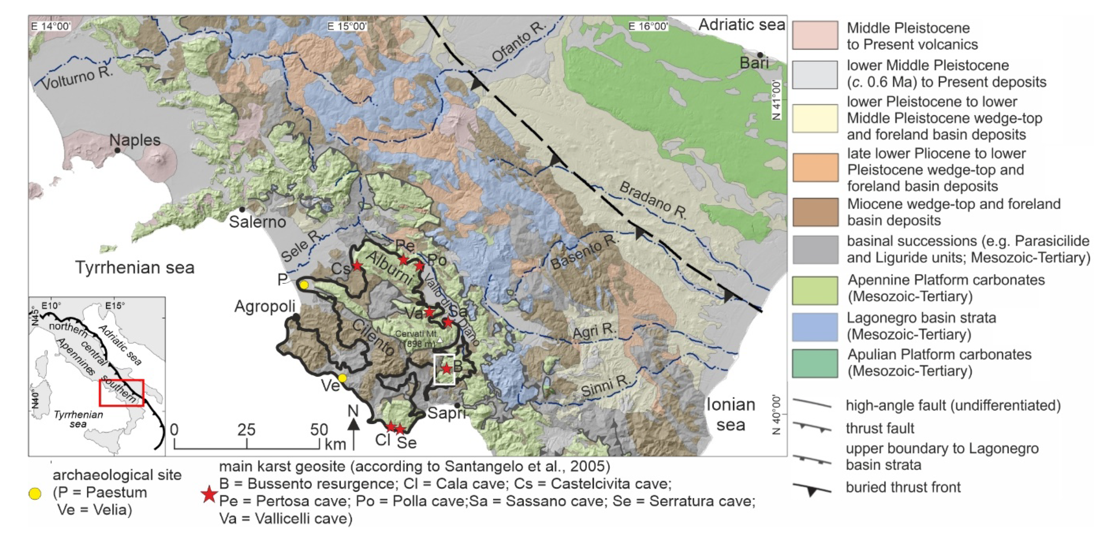
1.2. The Cilento, Vallo di Diano and Alburni UNESCO Global Geopark
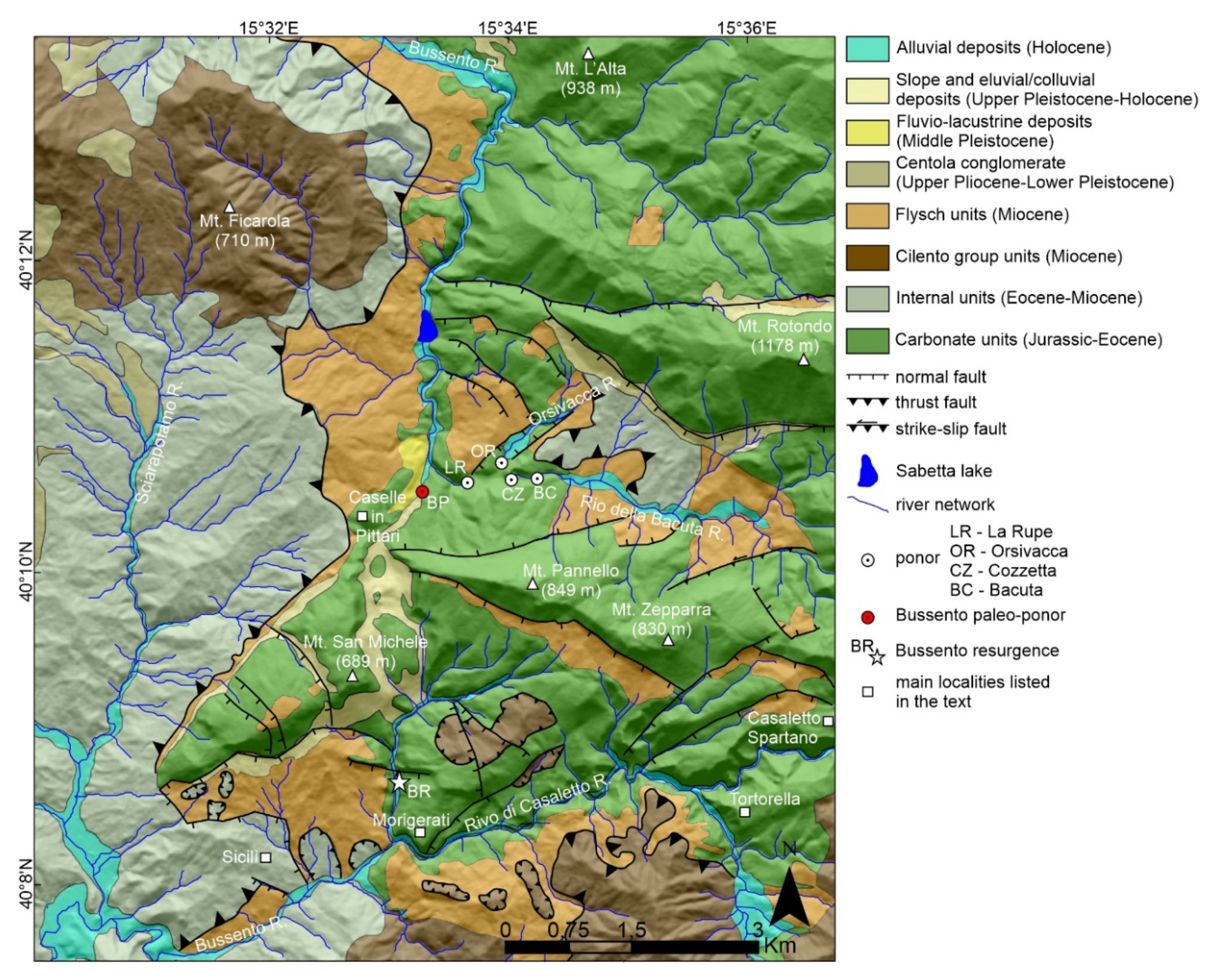
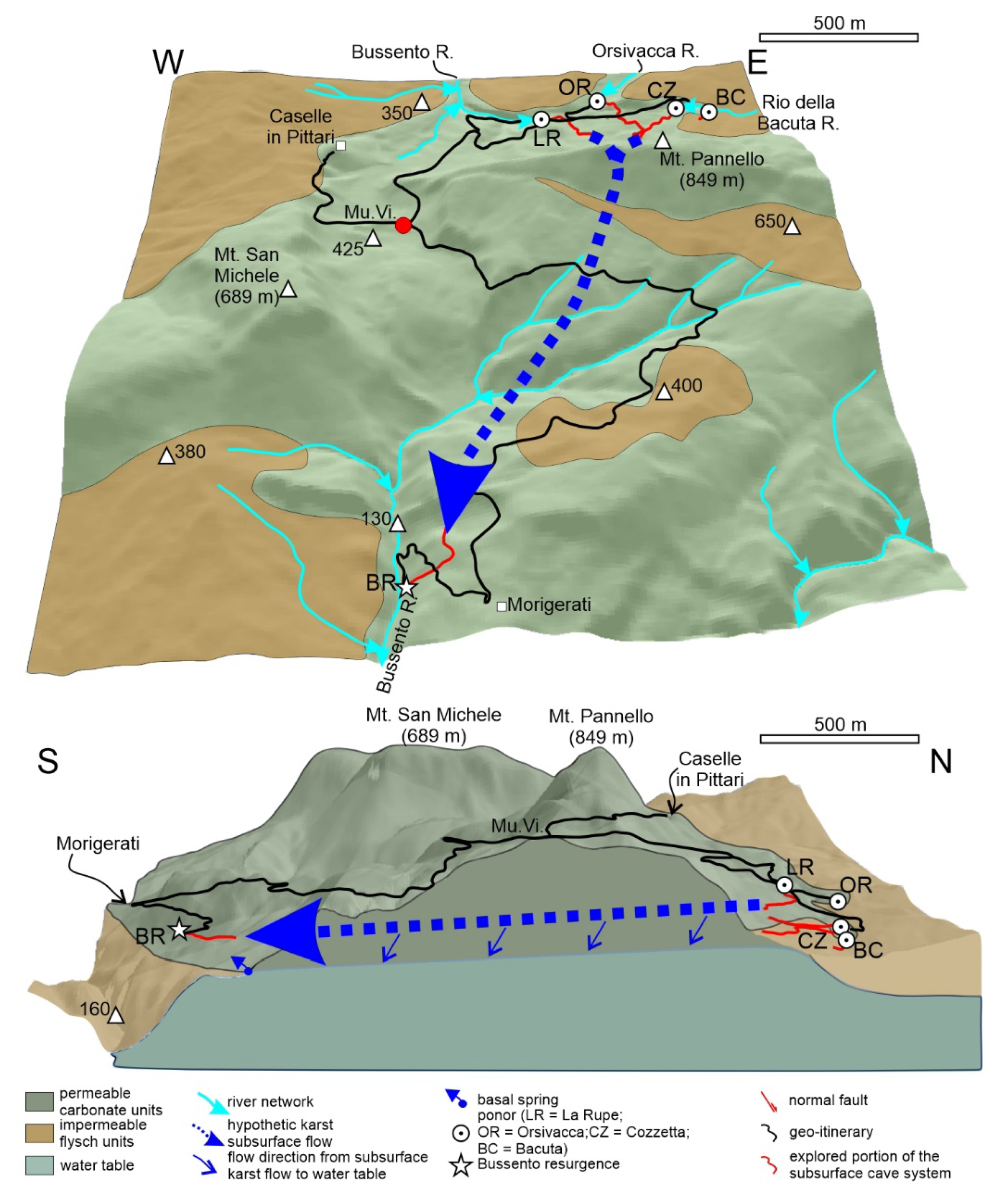
2. Study Area: The Middle Bussento Karst System
3. Materials and Methods
4. Results
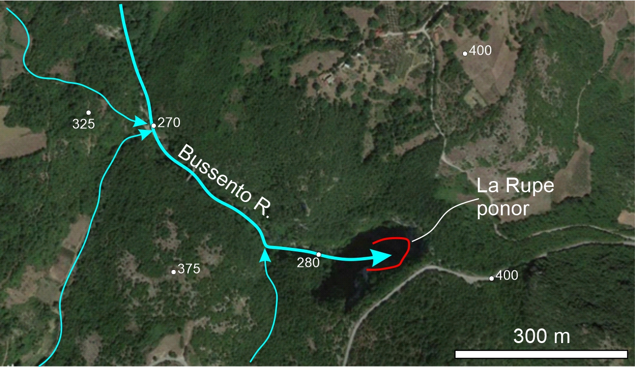
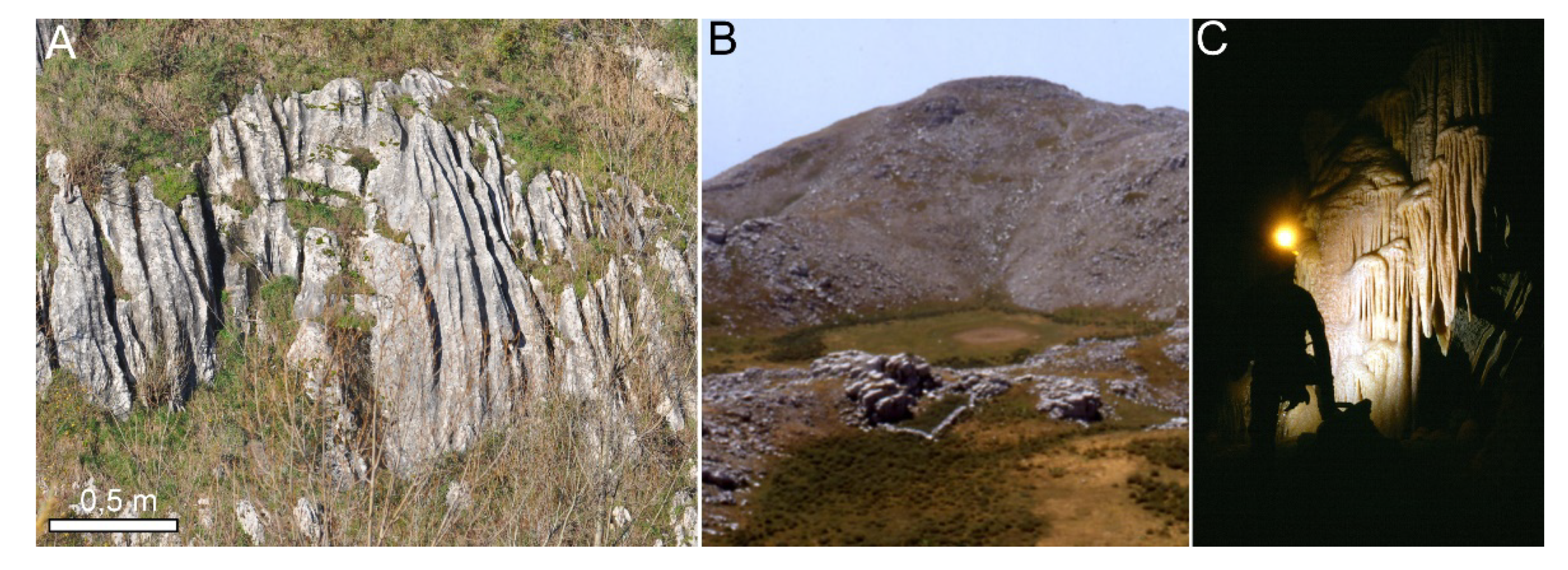
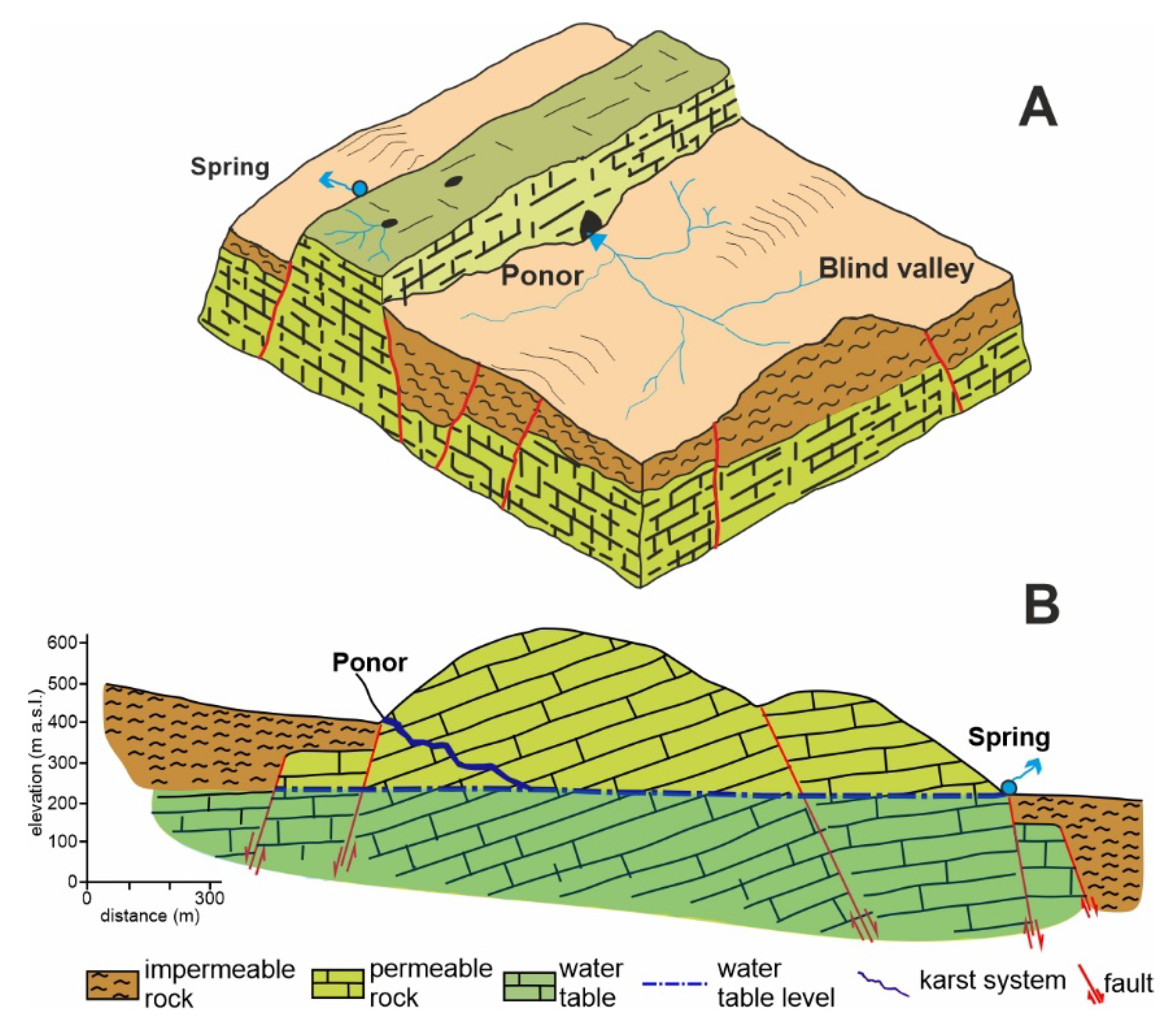
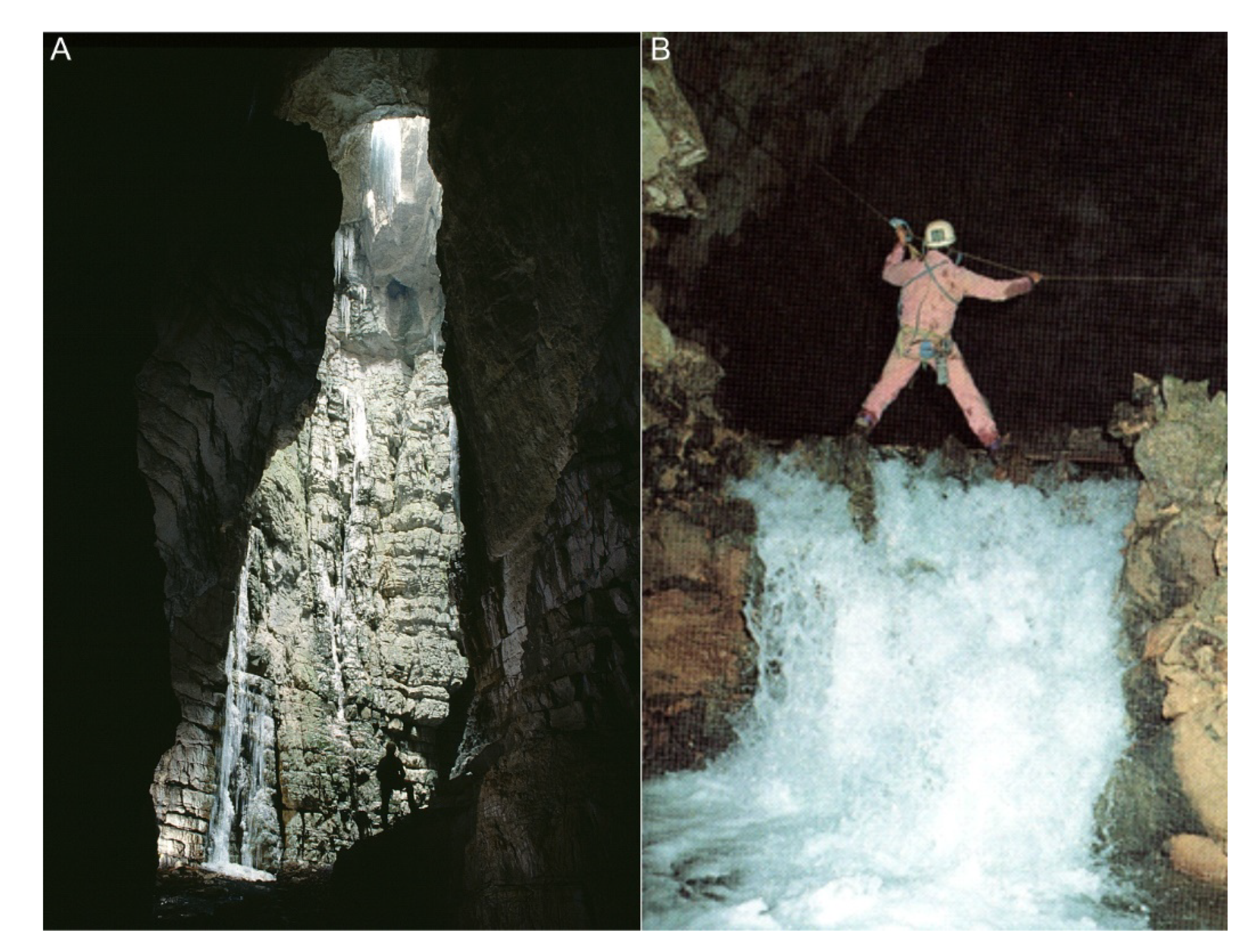
4.1. Karst Landforms (Ponors, Blind Valleys, Resurgences, and Karst Springs): Importance for Environmental Education
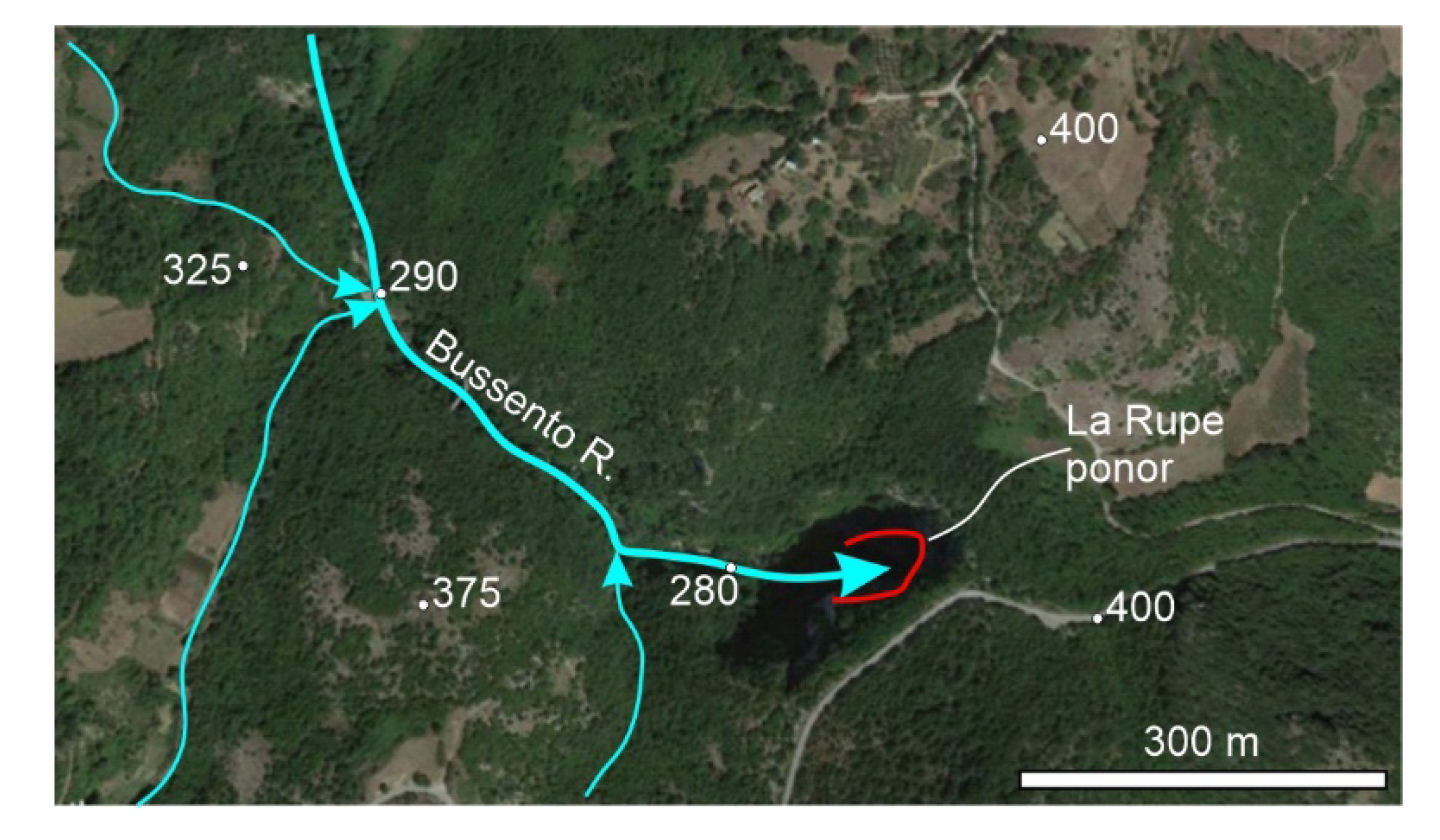
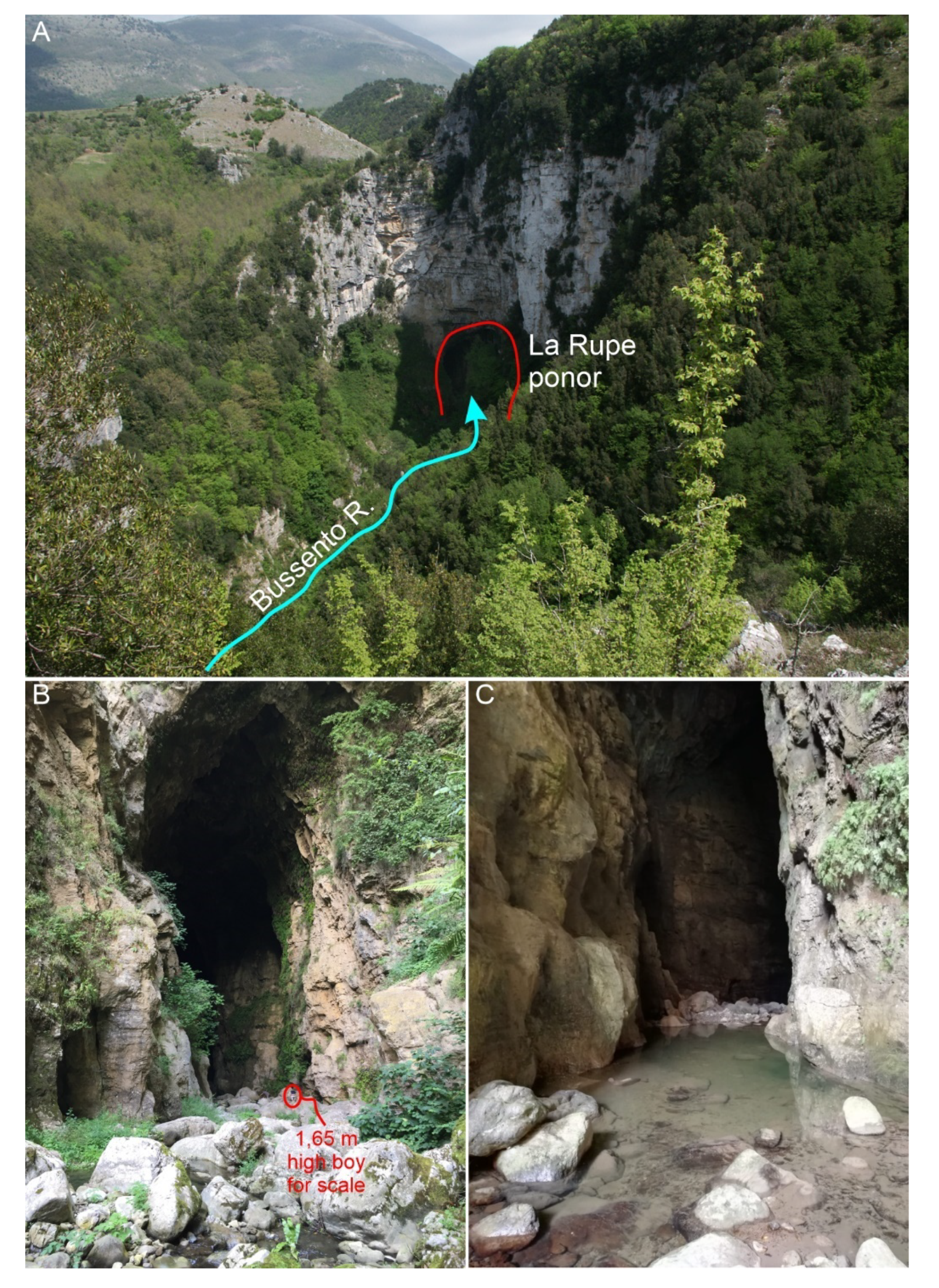
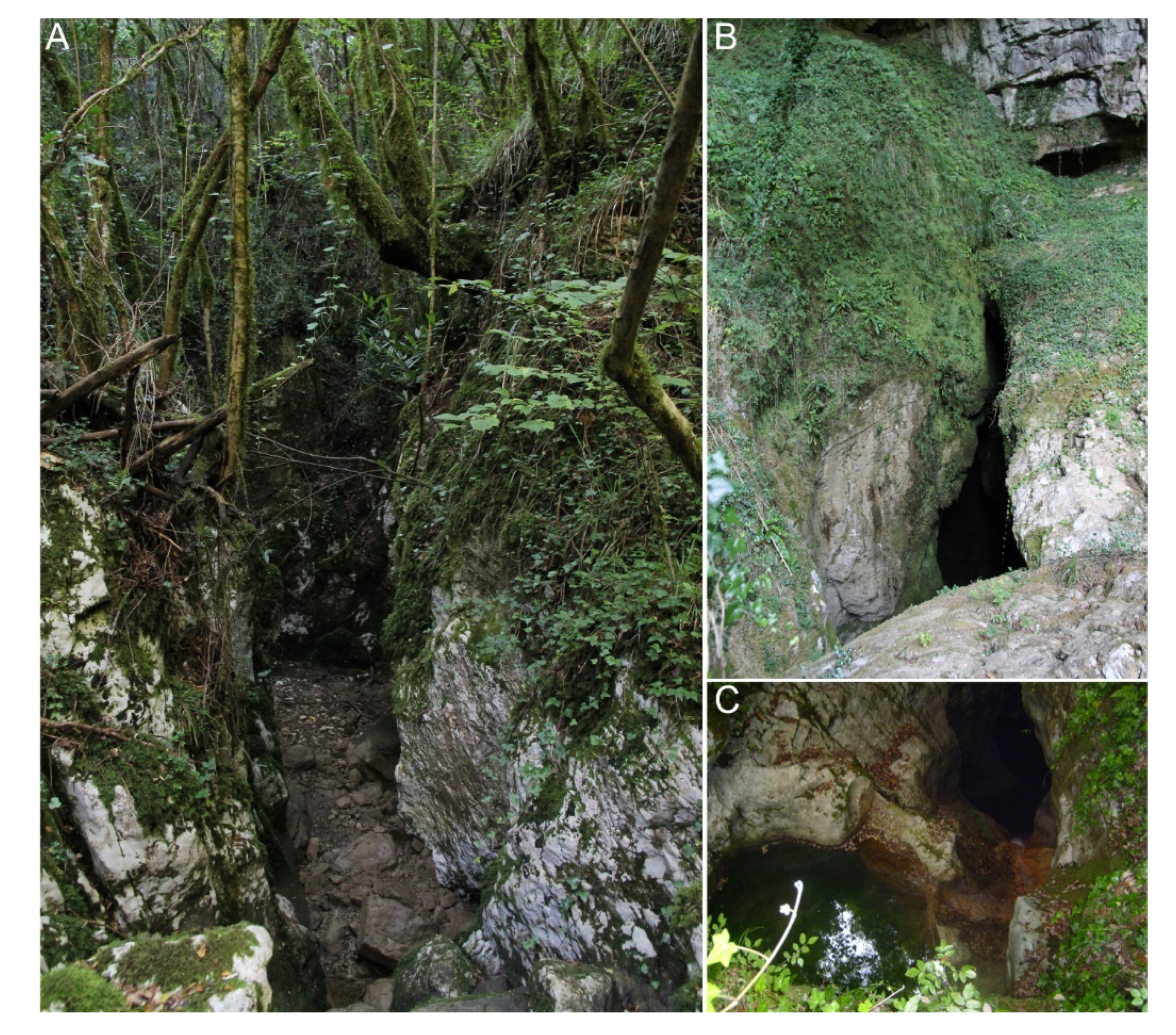
4.2. The Karst Ponors and the Blind Valley of the Bussento River: Proposed Geoitinerary
5. Discussion
5.1. Geotourism in Karst Area
5.2. Promoting Geotourism in the Middle Bussento Karst System: What Has Been Done and What Can Be Done
5.3. SWOT Analysis and VSG Index
6. Conclusions
Author Contributions
Funding
Acknowledgments
Conflicts of Interest
References
- Senato Della Repubblica Italiana. Available online: https://www.senato.it/documenti/repository/istituzione/costituzione.pdf (accessed on 3 March 2020).
- Eder, F.W.; Patzak, M. Geoparks—Geological attractions: A tool for public education, recreation and sustainable economic development. Episodes 2004, 27, 162–164. [Google Scholar] [CrossRef] [Green Version]
- Brilha, J. Geoheritage and geoparks. In Geoheritage. Assessment, Protection, and Management; Reynard, E., Brilha, J., Eds.; Elsevier: Amsterdam, The Netherlands, 2018; pp. 323–334. [Google Scholar] [CrossRef]
- UNESCO Website. Available online: https://whc.unesco.org/en/list/ (accessed on 3 March 2020).
- Patzak, M.; Eder, W. “UNESCO GEOPARK” A new Programme—A new UNESCO label. Geol. Balc. 1998, 28, 33–35. [Google Scholar]
- Zouros, N. The European Geoparks Network Geological heritage protection and local development. Episodes 2004, 27, 165–171. [Google Scholar] [CrossRef] [Green Version]
- Nowlan, G.S.; Bobrowsky, P.; Clague, J. Protection of geological heritage: A North American perspective on Geoparks. Episodes 2004, 27, 172–176. [Google Scholar] [CrossRef] [PubMed] [Green Version]
- Global Geopark Website. Available online: http://www.globalgeopark.org/aboutGGN/list/index.htm (accessed on 3 March 2020).
- UNESCO Global Geopark Definition. Available online: http://www.globalgeopark.org/aboutGGN/6398.htm (accessed on 1 April 2020).
- Bruschi, V.M.; Coratza, P. Geoheritage and environmental impact assessment (eia). In Geoheritage. Assessment, Protection, and Management; Reynard, E., Brilha, J., Eds.; Elsevier: Amsterdam, The Netherlands, 2018; pp. 251–264. [Google Scholar] [CrossRef]
- Brilha, J. Inventory and Quantitative Assessment of Geosites and Geodiversity Sites: A Review. Geoheritage 2016, 8, 119–134. [Google Scholar] [CrossRef] [Green Version]
- Newsome, D.; Dowling, R. Geoheritage and geotourism. In Geoheritage. Assessment, Protection, and Management; Reynard, E., Brilha, J., Eds.; Elsevier: Amsterdam, The Netherlands, 2018; pp. 305–321. [Google Scholar] [CrossRef]
- Reynard, E.; Brilha, J. Geoheritage: A Multidisciplinary and Applied Research Topic. In Geoheritage. Assessment, Protection, and Management; Reynard, E., Brilha, J., Eds.; Elsevier: Amsterdam, The Netherlands, 2018; pp. 3–9. [Google Scholar] [CrossRef]
- Hose, T.A. Selling the Story of Britain’s Stone. Environ. Interpret. 1995, 10, 16–17. [Google Scholar]
- Hose, T.A. 3G’s for modern geotourism. Geoheritage 2012, 4, 7–24. [Google Scholar] [CrossRef]
- Dowling, R.; Newsome, D. The scope and nature of geotourism. In Geotourism; Dowling, R., Newsome, D., Eds.; Routledge: Oxford, UK, 2006; pp. 31–53. [Google Scholar]
- Newsome, D.; Dowling, R.K. Setting an agenda for geotourism. In Geotourism: The Tourism of Geology and Landscape; Newsome, D., Dowling, R., Eds.; Goodfellow Publishers Limited: Oxford, UK, 2010; pp. 1–12. [Google Scholar]
- Migoń, P.; Różycka, M.; Michniewicz, A. Conservation and Geotourism Perspectives at Granite Geoheritage Sites of Waldviertel, Austria. Geoheritage 2018, 10, 11–21. [Google Scholar] [CrossRef]
- Bentivenga, M.; Cavalcante, F.; Mastronuzzi, G.; Palladino, G.; Prosser, G. Geoheritage: The Foundation for Sustainable Geotourism. Geoheritage 2019, 11, 1367–1369. [Google Scholar] [CrossRef] [Green Version]
- Ólafsdóttir, R.; Tverijonaite, E. Geotourism: A Systematic Literature Review. Geosciences 2018, 8, 234. [Google Scholar] [CrossRef] [Green Version]
- Dowling, R.; Newsome, D. Geotourism: Definition, characteristics and international perspectives. In Handbook of Geotourism; Dowling, R., Newsome, D., Eds.; Edward Elgar: Cheltenham, UK, 2018; pp. 1–22. [Google Scholar]
- Hose, T.A. Geotourism, or can tourists become casual rock hounds? In Geology on Your Doorstep; Bennett, M.R., Doyle, P., Larwood, J.G., Prosser, C.D., Eds.; The Geological Society: London, UK, 1996; pp. 207–228. [Google Scholar]
- Hose, T.A. European geotourism: Geological interpretation and geoconservation promotion for tourists. In Geological Heritage: Its Conservation and Management; Barretino, D., Wimbledon, W.A.P., Gallego, E., Eds.; Instituto Tecnologico GeoMinero de Espana: Madrid, Spain, 2000; pp. 127–146. [Google Scholar]
- Hose, T.A. Towards a history of Geotourism: Definitions, antecedents and the future. In The History of Geoconservation; Burek, C.V., Prosser, C.D., Eds.; The Geological Society: London, UK, 2008; pp. 37–60. [Google Scholar]
- Pralong, J.P. Geotourism: A new form of tourism utilising natural landscapes and based on imagination and emotion. Tour. Rev. 2006, 61, 20–25. [Google Scholar] [CrossRef]
- The Arouca Declaration. Available online: http://www.unesco.org/new/fileadmin/MULTIMEDIA/HQ/SC/pdf/Geopark_Arouca_Declaration_EGN_2012.pdf (accessed on 2 April 2020).
- Reynard, E. Protecting Stones: Conservation of erratic blocks in Switzerland. In Dimension Stone 2004. New Perspectives for a Traditional Building Material; Prykril, R., Ed.; A.A. Balkema Publishers: Leiden, The Netherlands, 2004; pp. 3–7. [Google Scholar]
- Panizza, M. Geomorphosites: Concepts, methods and examples of geomorphological survey. Chin. Sci. Bull. 2001, 46, 4–6. [Google Scholar] [CrossRef]
- Reynard, E.; Panizza, M. Geomorphosites: Definition, assessment and mapping. Géomorphologie 2005, 11, 177–180. [Google Scholar] [CrossRef] [Green Version]
- Reynard, E.; Coratza, P. Geomorphosites and geodiversity: A new domain of research. Geogr. Helv. 2007, 62, 138–139. [Google Scholar] [CrossRef]
- Reynard, E.; Coratza, P. Scientific research on geomorphosites. A review of the activities of the IAG working group on geomorphosites over the last twelve years. Geogr. Fis. Dinam. Quat. 2013, 36, 159–168. [Google Scholar] [CrossRef]
- Reynard, E.; Fontana, G.; Kozlik, L.; Scapozza, C. A method for assessing the scientific and additional values of geomorphosites. Geogr. Helv. 2007, 62, 148–158. [Google Scholar] [CrossRef]
- Reynard, E.; Coratza, P.; Regolini-Bissig, G. (Eds.) Geomorphosites; Pfeil: München, Germany, 2009; p. 240. [Google Scholar]
- Serrano, E.; González Trueba, J.J. Assessment of geomorphosites in natural protected areas: The Picos de Europa National Park (Spain). Géomorphologie 2005, 3, 197–208. [Google Scholar] [CrossRef] [Green Version]
- Zouros, N. Geomorphosite assessment and management in protected areas of Greece. Case study of the Lesvos Island-coastal geomorphosites. Geogr. Helv. 2007, 62, 69–180. [Google Scholar] [CrossRef]
- Miccadei, E.; Piacentini, T.; Esposito, G. Geomorphosites and geotourism in the parks of the Abruzzo region (Central Italy). Geoheritage 2011, 3, 233–251. [Google Scholar] [CrossRef]
- Pralong, J.P. A method for assessing the tourist potential and use of geomorphological sites. Géomorphologie 2005, 3, 189–196. [Google Scholar] [CrossRef]
- Piacente, S.; Coratza, P. (Eds.) Geomorphological sites and geodiversity. Il Quat. 2005, 18, 332. [Google Scholar]
- Pereira, P.; Pereira, D.; Caetano Alves, M.I. Geomorphosite assessment in Montesinho Natural Park (Portugal). Geogr. Helv. 2007, 62, 159–168. [Google Scholar] [CrossRef] [Green Version]
- Gregori, L.; Melelli, L. Geotourism & Geomorphosites: The G.I.S. Solution. Il Quat. 2005, 18, 285–292. [Google Scholar]
- Coratza, P.; Hoblea, F. The Specificities of Geomorphological Heritage. In Geoheritage. Assessment, Protection, and Management; Reynard, E., Brilha, J., Eds.; Elsevier: Amsterdam, The Netherlands, 2018; pp. 87–106. [Google Scholar] [CrossRef]
- Coratza, P.; De Waele, J. Geomorphosites and natural hazards: Teaching the Importance of Geomorphology in Society. Geoheritage 2012, 4, 195–203. [Google Scholar] [CrossRef]
- Mucivuna, V.C.; Reynard, E.; Garcia, M.d.G.M. Geomorphosites Assessment Methods: Comparative Analysis and Typology. Geoheritage 2019, 11, 1799–1815. [Google Scholar] [CrossRef]
- Pescatore, E.; Bentivenga, M.; Giano, S.I.; Siervo, V. Geomorphosites: Versatile Tools in Geoheritage Cultural Dissemination. Geoheritage 2019, 11, 1583–1601. [Google Scholar] [CrossRef]
- Santos, D.S.; Reynard, E.; Mansur, K.L.; Seoane, J.C.S. The specificities of geomorphosites and their influence on assessment procedures: A methodological comparison. Geoheritage 2019, 11, 2045–2064. [Google Scholar] [CrossRef]
- Bollati, I.; Zucali, M.; Giovenco, C.; Pelfini, M. Sport climbing sites as a new approach for education in Earth Science: Scientific representativeness of Montestrutto area (Austroalpine Domain, Piemonte, Italy). Ital. J. Geosci. 2014, 133, 187–199. [Google Scholar] [CrossRef]
- Bollati, I.; Coratza, P.; Panizza, V.; Pelfini, M. Lithological and structural control on italian mountain geoheritage: Opportunities for tourism, outdoor and educational activities. Quaest. Geogr. 2018, 37, 53–73. [Google Scholar] [CrossRef] [Green Version]
- Panizza, V.; Mennella, M. Assessing geomorphosites used for rock climbing: The example of Monteleone Rocca Doria (Sardinia, Italy). Geogr. Helv. 2007, 62, 181–191. [Google Scholar] [CrossRef] [Green Version]
- Piacentini, T.; Castaldini, D.; Coratza, P.; Farabollini, P.; Miccadei, E. Geotourism: Some examples in northern-central Italy. GeoJ. Tour. Geosites 2011, 8, 240–262. [Google Scholar]
- Aringoli, D.; Gentili, B.; Pambianchi, G.; Piscitelli, A.M. The contribution of the “Sibilla appenninica” legend to karst knowledge in the Sibillini Mountains (central Apennines, Italy). In Myth and Geology; Piccardi, L., Masse, W.B., Eds.; Geological Society, London, Special Publications: London, UK, 2007; Volume 273, pp. 329–340. [Google Scholar] [CrossRef]
- Aringoli, D.; Farabollini, P.; Gentili, B.; Materazzi, M.; Pambianchi, G. Geoparks and geoconservation: Examples in the southern Umb.ro-Marchean Apennines (central Italy). Geoacta Spec. Publ. 2008, 3, 1–14. [Google Scholar]
- Coratza, P.; Ghinoi, A.; Piacentini, D.; Valdati, J. Management of geomorphosites in high tourist vocation area: An example of Geo-Hiking maps in the Alpe di Fanes (Natural Park of Fanes-Senes_Braies, Italian Dolomites). GeoJ. Tour. Geosites 2008, 2, 106–117. [Google Scholar]
- Venturini, C.; Pasquarè Mariotto, F. Geoheritage Promotion Through an Interactive Exhibition: A Case Study from the Carnic Alps, NE Italy. Geoheritage 2019, 11, 450–469. [Google Scholar] [CrossRef]
- Santangelo, N.; Romano, P.; Santo, A. Geo-itineraries in the Cilento Vallo di Diano Geopark: A Tool for Tourism Development in Southern Italy. Geoheritage 2015, 7, 319–335. [Google Scholar] [CrossRef]
- Sisto, M.; Di Lisio, A.; Russo, F. The Mefite in the Ansanto Valley (Southern Italy): A Geoarchaeosite to Promote the Geotourism and Geoconservation of the Irpinian Cultural Landscape. Geoheritage 2020, 12, 29. [Google Scholar] [CrossRef]
- Margiotta, S.; Sansò, P. Abandoned Quarries and Geotourism: An Opportunity for the Salento Quarry District (Apulia, Southern Italy). Geoheritage 2017, 9, 463–477. [Google Scholar] [CrossRef]
- Pilogallo, A.; Nolè, G.; Amato, F.; Saganeiti, L.; Bentivenga, M.; Palladino, G.; Scorza, F.; Murgante, B.; Las Casas, G. Geotourism as a Specialization in the Territorial Context of the Basilicata Region (Southern Italy). Geoheritage 2019, 11, 1435–1445. [Google Scholar] [CrossRef]
- Bucci, F.; Tavarnelli, E.; Novellino, R.; Palladino, G.; Guglielmi, P.; Laurita, S.; Prosser, G.; Bentivenga, M. The History of the Southern Apennines of Italy Preserved in the Geosites Along a Geological Itinerary in the High Agri Valley. Geoheritage 2019, 11, 1489–1508. [Google Scholar] [CrossRef]
- Santangelo, N.; Santo, A.; Guida, D.; Lanzara, R.; Siervo, V. The geosites of the Cilento-Vallo di Diano national park (Campania region, southern Italy). Il Quat. 2005, 18, 101–112. [Google Scholar]
- Aloia, A.; De Vita, A.; Guida, D.; Toni, A.; Valente, A. National Park of Cilento and Vallo di Diano: Geodiversity, geotourism, geoarchaeology and historical tradition. In Proceedings of the 9th Europena Geopark Conference—European Geopark Network Mytilene Lesvos, Lesvos, Greece, 1–5 October 2010; p. 41. [Google Scholar]
- Aloia, A.; Guida, D.; Valente, A. Geodiversity in the Geopark of Cilento and Vallo di Diano as heritage and resource development. Rend. Online Soc. Geol. Ital. 2012, 21, 688–690. [Google Scholar]
- Aloia, A.; Guida, D. The Geosites: Geopark’s Gaia Synphony in the Cilento, Vallo Diano and Alburni Geopark, Geopark Book n. 1; Cilento, Vallo di Diano and Alburni Geopark: Vallo della Lucania, Italy, 2014. [Google Scholar]
- Calcaterra, D.; D’Argenio, B.; Ferranti, L.; Pappone, G.; Petrosino, P. Guide Geologiche Regionali, Campania e Molise; Società Geologica Italiana: Rome, Italy, 2016; p. 276. [Google Scholar]
- Valente, E.; Ascione, A.; Ciotoli, G.; Cozzolino, M.; Porfido, S.; Sciarra, A. Do moderate magnitude earthquakes generate seismically induced ground effects? The case study of the M w = 5.16, 29th December 2013 Matese earthquake (southern Apennines, Italy). Int. J. Earth Sci. 2018, 107, 517–537. [Google Scholar] [CrossRef] [Green Version]
- Italian National Parks Website. Available online: http://www.parks.it/parco.nazionale.cilento/map.php (accessed on 6 March 2020).
- ISPRA Geosites Database. Available online: http://sgi.isprambiente.it/GeositiWeb/default.aspx?ReturnUrl=%2fgeositiweb%2f (accessed on 5 March 2020).
- Cilento, Vallo di Diano and Alburni Geopark Geosites Database. Available online: http://www.cilentoediano.it/it/geositi-gli-ambiti-paesaggio (accessed on 5 March 2020).
- Allocca, V.; Celico, F.; Celico, P.; De Vita, P.; Fabbrocino, S.; Mattia, C.; Monacelli, G.; Musilli, I.; Piscopo, V.; Scalise, A.R.; et al. Note Illustrative Della Carta Idrogeologica Dell’italia Meridonale; Istituto Poligrafico e Zecca dello Stato: Rome, Italy, 2007; p. 217. [Google Scholar]
- Guida, D.; Guida, M.; Luise, D.; Salzano, G.; Vallario, A. Idrogeologia del Cilento. Geol. Romana 1980, 19, 349–369. [Google Scholar]
- Santangelo, N.; Santo, A. Endokarst processes in the Alburni massif (Campania, southern Italy): Evolution of ponors and hydrogeological implications. Z. Geomorphol. 1997, 41, 229–246. [Google Scholar]
- Geosites Census in the Bussento River Area by the Geopark. Available online: http://www.cilentoediano.it/it/node/1112 (accessed on 6 March 2020).
- Piperno, M. La Preistoria alle Falde del M. Cervati. Parco Nazionale del Cilento e Vallo di Diano; Cilento, Vallo di Diano and Alburni Geopark: Vallo della Lucania, Italy, 2001; p. 12. [Google Scholar]
- Fondazione MIDA Website. Available online: http://fondazionemida.com/ (accessed on 5 March 2020).
- Braitenberg, C.; Pivetta, T.; Rossi, G.; Ventura, P.; Betic, A. Karst caves and hydrology between geodesy and archeology: Field trip notes. Geodesy Geodynamics 2018, 9, 262–269. [Google Scholar] [CrossRef]
- Sheet 520—Sapri of the Geological Map of Italy at Scale 1:50000, Carg Project. Available online: http://www.isprambiente.gov.it/Media/carg/520_SAPRI/Foglio.html (accessed on 6 March 2020).
- Cello, G.; Mazzoli, S. Apennine Tectonics in Southern Italy: A review. J. Geodyn. 1998, 27, 191–211. [Google Scholar] [CrossRef]
- Menardi Noguera, A.; Rea, G. Deep structure of the Campanian–Lucanian Arc (Southern Apennine, Italy). Tectonophysics 2000, 324, 239–265. [Google Scholar] [CrossRef]
- Vitale, S.; Ciarcia, S. Tectono-stratigraphic and kinematic evolution of the southern Apennines/Calabria–Peloritani Terrane system (Italy). Tectonophysics 2013, 583, 164–182. [Google Scholar] [CrossRef]
- Ciarcia, S.; Vitale, S.; Di Staso, A.; Iannace, A.; Mazzoli, S.; Torre, M. Stratigraphy and tectonics of an Internal Unit of the southern Apennines: Implications for the geodynamic evolution of the peri-Tyrrhenian mountain belt. Terra Nova 2009, 21, 88–96. [Google Scholar] [CrossRef]
- Ciarcia, S.; Mazzoli, S.; Vitale, S.; Zattin, M. On the tectonic evolution of the Ligurian accretionary complex in southern Italy. Geol. Soc. Am. Bull. 2012, 124, 463–483. [Google Scholar] [CrossRef]
- Vitale, S.; Ciarcia, S.; Mazzoli, S.; Iannace, A.; Torre, M. Structural analysis of the ‘Internal’ Units of Cilento, Italy: New constraints on the Miocene tectonic evolution of the southern Apennine accretionary wedge. CR Geosci. 2010, 342, 475–482. [Google Scholar] [CrossRef]
- Vitale, S.; Ciarcia, S.; Mazzoli, S.; Zaghloul, M.N. Tectonic evolution of the ‘Liguride’ accretionary wedge in the Cilento area, southern Italy: A record of early Apennine geodynamics. J. Geodyn. 2011, 51, 25–36. [Google Scholar] [CrossRef] [Green Version]
- D’Elia, G.; Guida, M.; Terranova, C. Osservazioni sui fenomeni di deformazione gravitativa profonda nel bacino del fiume Bussento (Campania). Boll. Soc. Geol. Ital. 1987, 106, 253–264. [Google Scholar]
- Cvijc, J. La geographie des terrains calcaires. Monographies Acad. Serbe Sc. et Arts 1960, 26, 141–207. [Google Scholar]
- Ford, D.; Williams, P. Karst Geomorphology and Geology; Unwin Hyman: London, UK, 1989. [Google Scholar]
- Bovolin, V.; Cuomo, A.; Guida, D. Hydraulic modeling of flood pulses in the Middle Bussento Karst System (MBSKS), UNESCO Cilento Global Geopark, southern Italy. Hydrol. Process. 2017, 31, 639–653. [Google Scholar] [CrossRef]
- Guida, M.; Guida, D.; Guadagnuolo, D.; Cuomo, A.; Siervo, V. Using Radon-222 as a Naturally Occurring Tracer to investigate the streamflow-groundwater interactions in a typical Mediterranean fluvial-karst landscape: The interdisciplinary case study of the Bussento river (Campania region, Southern Italy). WSEAS Trans. Syst. 2013, 12, 85–104. [Google Scholar]
- Pica, A.; Fredi, P.; Del Monte, M. The Ernici Mountains Geoheritage (Central Apennines, Italy): Assessment of the geosites for Geotourism development. GeoJ. Tour. Geosites 2014, 14, 193–206. [Google Scholar]
- Santo, A.; Budetta, P.; Forte, G.; Marino, E.; Pignalosa, A. Karst collapse susceptibility assessment: A case study on the Amalfi Coast (Southern Italy). Geomorphology 2017, 285, 247–259. [Google Scholar] [CrossRef]
- Ford, D.; Williams, P.D. Karst Hydrogeology and Geomorphology; John Wiley & Sons: Hoboken, NJ, USA, 2013. [Google Scholar]
- De Waele, J.; Gutiérrez, F.; Parise, M.; Plan, L. Geomorphology and natural hazards in karst areas: A review. Geomorphology 2011, 134, 1–8. [Google Scholar] [CrossRef]
- Celico, F. Idrogeologia dei massicci carbonatici delle piane quaternarie e delle aree vulcaniche dell’Italia centro-meridionale (Marche e Lazio meridionale, Abruzzo, Molise e Campania). Quad. Cassa Mezzog. 1983, 4, 1–225. [Google Scholar]
- Santo, A. Karst processes and potential vulnerability of the Campanian carbonatic aquifers: The state of the knowledge. In Proceedings of the International Conference on Enviromental Changes in Karst areas. I.G.U.-U.I.S.-University of Padua, Padua, Italy, 15–27 September 1991; pp. 95–107. [Google Scholar]
- Russo, N.; Del Prete, S.; Giulivo, I.; Santo, A. Grotte e Speleologia della Campania; Elio Sellino Editore: Avellino, Italy, 2005; pp. 363–396. [Google Scholar]
- Santo, A.; Liguori, M.; Aquino, S.; Galasso, M. Problemi di geologia ambientale nei polje appenninici: l’esempio della Piana di Forino (Campania). Il Quat. 1998, 11, 233–245. [Google Scholar]
- Parise, M.; Santo, A. Tracer Tests History in the Alburni Massif (Southern Italy). IOP Conf. Ser. Earth Environ. Sci. 2017, 95, 062006. [Google Scholar] [CrossRef] [Green Version]
- Italian Excursionist Federation Website, Classification of Muletrack. Available online: https://www.fieitalia.com/fie/cosa-facciamo/sport/escursionismo/classificazione-dei-sentieri/ (accessed on 13 March 2020).
- Campania Region Cave Database. Available online: http://sit.regione.campania.it/catastogrotte/ (accessed on 13 March 2020).
- Calaforra, J.M.; Fernandez-Cortes, A. Geotourism in Spain: Resources, environmental management. In Geotourism. Sustainabilty, Impact and Management; Dowling, R., Newsome, D., Eds.; Elsevier: Oxford, UK, 2006; pp. 199–220. [Google Scholar]
- Chen, Z.; Auler, A.S.; Bakalowicz, M.; Drew, D.; Griger, F.; Hartmann, J.; Jiang, G.; Moosdorf, N.; Richts, A.; Stevanovic, Z.; et al. The World Karst Aquifer Mapping project: Concept, mapping procedure and map of Europe. Hydrogeol. J. 2017, 25, 771–785. [Google Scholar] [CrossRef] [Green Version]
- Ruban, D. Karst as Important Resource for Geopark-Based Tourism: Current State and Biases. Resources 2018, 7, 82. [Google Scholar] [CrossRef] [Green Version]
- Cigna, A.A.; Forti, P. Caves: The Most Important Geotouristic Feature in the World. Tour. Karst Areas 2013, 6, 9–26. [Google Scholar]
- Kim, S.S.; Kim, M.; Park, J.; Guo, Y. Cave tourism: Tourists’ characteristics, motivations to visit, and the segmentation of their behavior. Asia Pac. J. Tour. Res. 2008, 13, 299–318. [Google Scholar] [CrossRef]
- Rivas, A.; Durán, J.J.; López-Martínez, J. Spanish show caves as elements of the geological heritage. In Proceedings of the 4th International Show Caves Association Congress, Use of Modern Technologies in the Development of Caves for Tourism, Postojna, Slovenia, 21–27 October 2002; pp. 155–158. [Google Scholar]
- Doorne, S. Caves, cultures and crowds: Carrying capacity meets consumer sovereignty. J. Sustain. Tour. 2000, 8, 116–130. [Google Scholar] [CrossRef]
- Allan, M.; Dowling, R.K.; Sanders, D. The motivation for visiting geosites: The case of Cristal Cave, Western Australia. GeoJ. Tour. Geosites 2015, 16, 141–152. [Google Scholar]
- Hurtado, H.; Downling, R.K.; Sanders, D. An explanatory study to develop a Geotourism typology model. Int. J. Tour. Res. 2014, 16, 608–613. [Google Scholar] [CrossRef]
- Kiernan, K. The nature conservation, Geotourism and poverty reduction nexus in developing countries: A case study from the Lao PDR. Geoheritage 2013, 5, 207–225. [Google Scholar] [CrossRef]
- Pulido-Bosch, A.; Martin-Rosales, W.; Lopez-Chicano, M.; Rodriguez-Navarro, C.M.; Vallejos, A. Human impact in a tourist karstic cave (Aracena, Spain). Environ. Geol. 1997, 31, 142–149. [Google Scholar] [CrossRef] [Green Version]
- Baker, A.; Genty, D. Environmental pressures on conserving cave speleothems: Effects of changing surface land use and increased cave tourism. J. Environ. Manag. 1998, 53, 165–175. [Google Scholar] [CrossRef]
- Calaforra, J.M.; Fernandez-Cortes, A.; Sanchez-Martos, F.; Gisbert, J.; Pulido-Bosch, A. Environmental control for determining human impact and permanent visitor capacity in a potential show cave before tourist use. Environ. Conserv. 2003, 30, 160–167. [Google Scholar] [CrossRef]
- Eagles, P.F.J.; McCool, S.F.; Haynes, C.D. Sustainable Tourism in Protected Areas Guidelines for Planning and Management; IUCN: Gland, Switzerland, 2002. [Google Scholar]
- Williams, P. World Heritage Caves and Karst; IUCN: Gland, Switzerland, 2008; p. 57. [Google Scholar]
- Del Vecchio, U.; Mitrano, T.; Ruocco, M. Recenti esplorazioni al corso sotterraneo del fiume Bussento. In Proceedings of the Atti del II Convegno Regionale di Speleologia, Caselle in Pittari, Italy, 3–4 June 2010; pp. 21–29. [Google Scholar]
- Guida, D.; Ragone, G. Valutazione parametrica della vulnerabilità del sistema carsico del medio Bussento (parco nazionale del Cilento e Vallo di Diano). In Proceedings of the Atti del II Convegno Regionale di Speleologia, Caselle in Pittari, Italy, 3–4 June 2010; pp. 263–276. [Google Scholar]
- Mitrano, T. Inghiottitoio del Bussento (CP18). L’Appennino Meridionale 2008, 5, 252–257. [Google Scholar]
- Mitrano, T. Atti del II Convegno Regionale di Speleologia; Federazione Speleologica Campana: Caselle in Pittari, Italy, 2010; p. 281. [Google Scholar]
- Ruocco, M.; Avitabile, M.; Catuogno, F. Mostre ed attività didattiche al II convegno regionale di speleologia, 3–4 Guigno 2010. In Proceedings of the Atti del II Convegno Regionale di Speleologia, Caselle in Pittari, Italy, 3–4 June 2010; pp. 277–281. [Google Scholar]
- Middle Bussento Ponors Website. Available online: http://www.inghiottitoiodelbussento.it/ (accessed on 15 March 2020).


| Value of a Site for Geotourism | ||
|---|---|---|
| VSG = RP + RR + SCE + SAC + AC, VSG max = 25 | ||
| Attributes | Values | |
| Representativeness RP | 0, 1, 3, 5 | |
| Ideal model correspondence | 5, 3, 3, 1, 0 |  |
| Peculiarity (lithostratigraphy, carsism, hydrology, paleontology, geomorphology, structural geology, mineralogy) | 5, 3, 3, 1, 0 | |
| Typicality | 5, 3, 3, 1, 0 | |
| Interest peculiarity | 5, 3, 3, 1, 0 | |
| Rareness RR | 0, 1, 3, 5 | |
| Geographical range | local, regional, national, international | Two-way table |
| Frequency | 5, 4, 3, 1, 0 | |
| Scenic-aesthetic SCE | 0, 1, 3, 5 | |
| Viewpoints | 5, 3, 1, 0 |  summarize intervals summarize intervals |
| Cromatic contrast | 5, 3, 1, 0 | |
| Landform queerness | 5, 0 | |
| Historical-archeological-cultural SAC | 0, 1, 3, 5 | |
| National restriction | 3, 5 (area, geosite) |  summarize intervals summarize intervals |
| Regional/local restriction | 1, 3 (area, geosite) | |
| Protected area | 3, 5, 1 | |
| Other (archeological, monumental, architectural values; legends, stories, tradition; toponym) | 2, 2, 1 | |
| Accessibility AC | 0, 1, 3, 5 | |
| Ways to approach the site | 5, 3, 1 |  summarize intervals summarize intervals |
| Difficulty to approach the site | 5, 4, 3, 1 | |
| Services | 5, 4, 3, 1, 0 | |
| The Middle Bussento Karst System Geoitinerary | |||||
|---|---|---|---|---|---|
| Length | Duration | Number of Stops | How to Move between Stops | Type of Itinerary (According to Italian Excursionist Federation classification, [97]) | |
| ~17 km | It could be completed in a one-day itinerary (expected duration is 8 h) or split in a two-day itinerary | 5 | by walking or by car | excursionist | |
| Stop no. 1: La Rupe ponor (3 km far from the urban center of Caselle in Pittari) | |||||
| Path Length | Duration | Difference in elevation | Main geological and geomorphological features | ||
| 1 km | 2 h | 180 m | La Rupe ponor; Bussento River blind valley; dissolution pans; karren | ||
| Stop no. 2: Orsivacca ponor (0.8 km far from stop no. 1) | |||||
| Path Length | Duration | Difference in elevation | Main geological and geomorphological features | ||
| 300 m | 1 h | 40 m | Orsivacca ponor; Orsivacca River blind valley | ||
| Stop no. 3: Rio della Bacuta valley (1.6 km far from stop no. 2) | |||||
| Length | Duration | Difference in elevation | Main geological and geomorphological features | ||
| 500 m | 1 h | 60 m | Cozzetta ponor; Bacuta ponor; Rio della Bacuta River blind valley | ||
| Stop no. 4: MU.VI. (3.2 km far from stop no. 3) | |||||
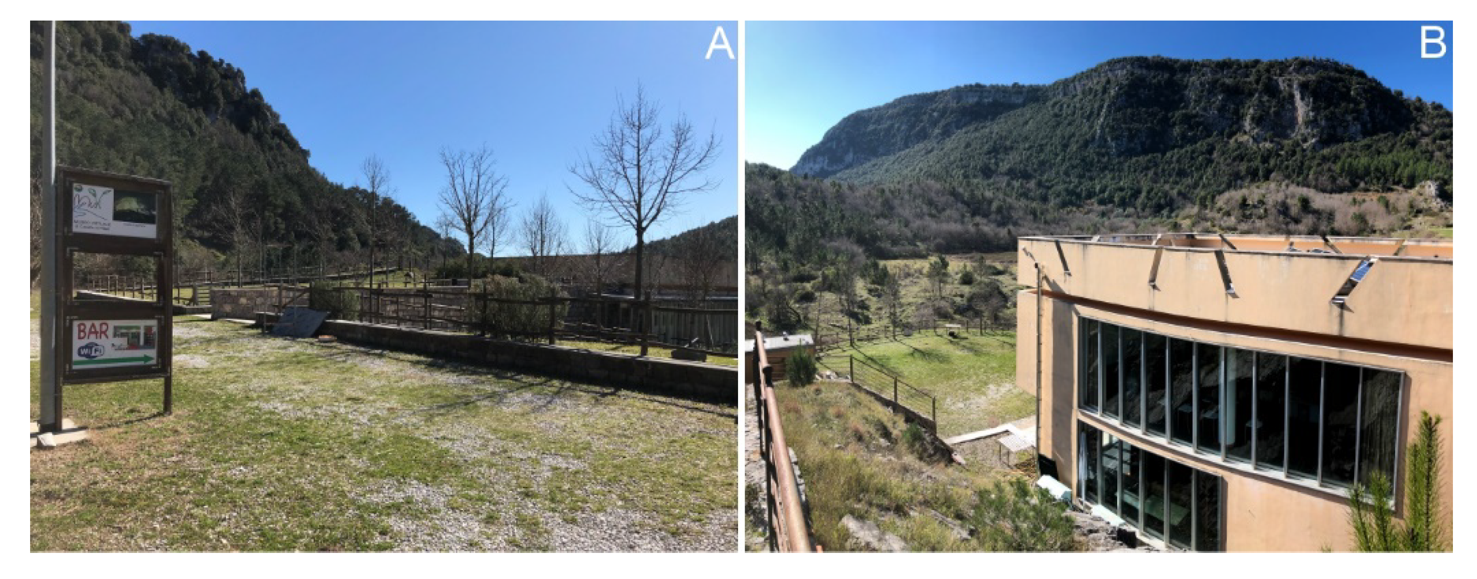
| Duration of the visit | Main geological and geomorphological features | ||||
| 1 h | Virtual tour of the Middle Bussento Karst System | ||||
| Stop no. 5: Bussento Resurgence (6.5 km far from stop no. 5) | |||||
| Length | Duration | Difference in elevation | Main geological and geomorphological features | ||
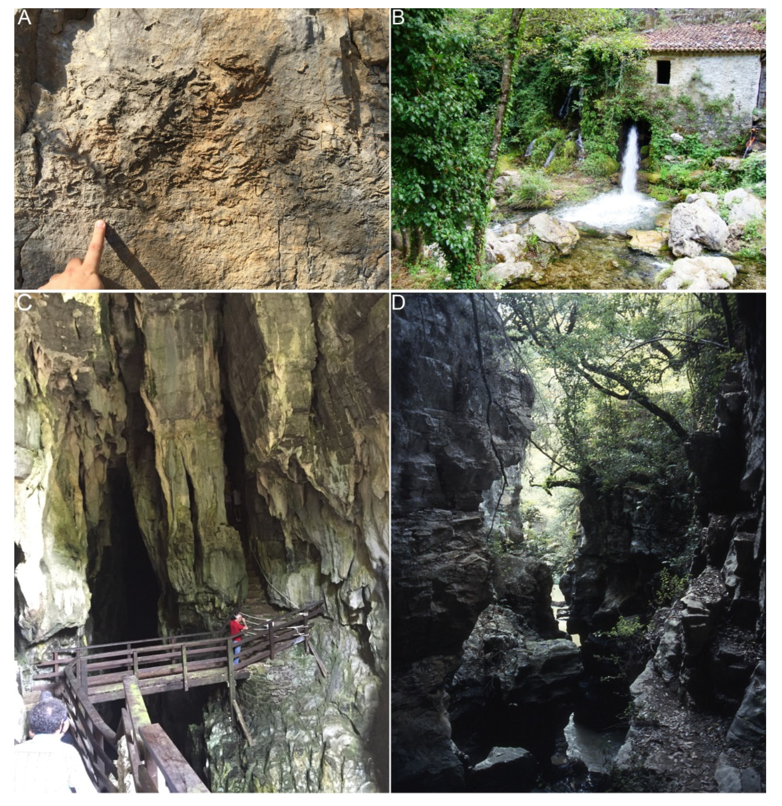
| 700 m | 2 h | 120 m | Bussento Resurgence; Bussento gorge; fossils of rudists; Mulino spring | ||
| Strengths | Weaknesses |
|---|---|
|
|
| Opportunities | Threats |
|
|
© 2020 by the authors. Licensee MDPI, Basel, Switzerland. This article is an open access article distributed under the terms and conditions of the Creative Commons Attribution (CC BY) license (http://creativecommons.org/licenses/by/4.0/).
Share and Cite
Valente, E.; Santo, A.; Guida, D.; Santangelo, N. Geotourism in the Cilento, Vallo di Diano and Alburni UNESCO Global Geopark (Southern Italy): The Middle Bussento Karst System. Resources 2020, 9, 52. https://0-doi-org.brum.beds.ac.uk/10.3390/resources9050052
Valente E, Santo A, Guida D, Santangelo N. Geotourism in the Cilento, Vallo di Diano and Alburni UNESCO Global Geopark (Southern Italy): The Middle Bussento Karst System. Resources. 2020; 9(5):52. https://0-doi-org.brum.beds.ac.uk/10.3390/resources9050052
Chicago/Turabian StyleValente, Ettore, Antonio Santo, Domenico Guida, and Nicoletta Santangelo. 2020. "Geotourism in the Cilento, Vallo di Diano and Alburni UNESCO Global Geopark (Southern Italy): The Middle Bussento Karst System" Resources 9, no. 5: 52. https://0-doi-org.brum.beds.ac.uk/10.3390/resources9050052