Review

Climate Risks Resilience Development: A Bibliometric Analysis of Climate-Related Early Warning Systems in Southern Africa

by
Israel Edem Agbehadji
1,*,
Stefanie Schütte
2,
Muthoni Masinde
3,
Joel Botai
1,4 and
Tafadzwanashe Mabhaudhi
1,2,4
1
Centre for Transformative Agricultural and Food Systems, School of Agricultural, Earth and Environmental Sciences, University of KwaZulu-Natal, Private Bag X01, Pietermaritzburg 3209, South Africa
2
Centre for Water Resources Research, School of Agricultural, Earth and Environmental Sciences, University of KwaZulu-Natal, Private Bag X01, Pietermaritzburg 3209, South Africa
3
Department of IT, Central University of Technology, Private Bag X20539, Bloemfontein 9301, South Africa
4
International Water Management Institute, Southern Africa Office, 333 Grosvenor Street, Pretoria 0083, South Africa
*
Author to whom correspondence should be addressed.
Submission received: 13 November 2023 / Revised: 20 December 2023 / Accepted: 21 December 2023 / Published: 26 December 2023
(This article belongs to the Special Issue Hydroclimate Dynamics and Extreme Weather Events in Africa)

Abstract

:
Early warning systems (EWS) facilitate societies’ preparedness and effective response capabilities to climate risks. Climate risks embody hazards, exposure, and vulnerability associated with a particular geographical area. Building an effective EWS requires consideration of the factors above to help people with coping mechanisms. The objective of this paper is to propose an approach that can enhance EWSs and ensure an effective climate risk resilience development. The paper focuses on the Southern African Development Community (SADC) region and highlights the issues with EWS, identifying weaknesses and characteristics of EWS to help in climate risk adaptation strategies. The SADC region was chosen as the context because it is a climate variability and change hotspot with many vulnerable populations residing in rural communities. Trending themes on building climate risk resilience were uncovered through scientific mapping and network analysis of published articles from 2008 to 2022. This paper contributes to on-going research on building climate risks resilience through early warning systems to identify hidden trends and emerging technologies from articles in order to enhance the operationalization and design of EWS. This review provides insight into technological interventions for assessing climate risks to build preparedness and resilience. From the review analysis, it is determined that there exists a plethora of evidence to support the argument that involving communities in the co-designing of EWS would improve risk knowledge, anticipation, and preparedness. Additionally, Fourth Industrial Revolution (4IR) technologies provide effective tools to address existing EWS’ weaknesses, such as lack of real-time data collection and automation. However, 4IR technology is still at a nascent stage in EWS applications in Africa. Furthermore, policy across societies, institutions, and technology industries ought to be coordinated and integrated to develop a strategy toward implementing climate resilient-based EWS to facilitate the operations of disaster risk managers. The Social, Institutional, and Technology model can potentially increase communities’ resilience; therefore, it is recommended to develop EWS.

1. Introduction

An early warning system is fundamental in building preparedness and response mechanisms to climate risks. Climate risks negatively impact society, adversely affecting lives, economic activities, and services, hindering education, water resources quality and supply, and wreck infrastructure [1]. When early warnings are communicated to vulnerable communities, it mitigates the negative impacts on communities. However, pre-empting the possible impacts of any climate-related event can be hindered by the lack of climate data and necessary supporting tools or devices. Unfortunately, there seems to be a “de-link” in climate risk information flow from established institutions to communities, influencing the ease of identifying vulnerable communities.
Climate risks are becoming more severe, and identifying and communicating climate risks is crucial for sustainable development. Though poorly developed infrastructures in developing nations could increase the vulnerability to climate-induced factors [2], failure to also communicate the climate risks can lead to reduced investment decisions and the continuation of “business as usual” trade practices, which led to climate change in the first place. Climate risk is a multi-dimensional construct of factors on hazards, exposure, vulnerability, and coping mechanisms. These factors ought to be considered in the EWS design to determine the risk level and the appropriate responses. For example, climate-sensitive sectors such as agriculture, built-environment, and water would need knowledge of climate risks to help build resilience to climate hazards, including floods, extreme heat, thunderstorms and lightning, wildfires, and drought [3]. The cardinal point in climate risk response is building resilience and understanding the nature of extreme climate events for an effective response strategy [4,5]. Though EWS is key to reducing the climate hazard impacts [6], it is often given a lower priority than other operational risks [7].
Adaptation strategy is key in building resilience to climate risks, which involves the ability of different systems to interact and facilitate society’s capacity to cope with climate risks. Building climate resilience enables the socio-ecological system and its components to anticipate, prepare for, or adapt and respond to events or trends related to climate in a timely and efficient manner. A system’s ability to generate climate information services and inform society has become relevant because of the increasing impact of weather events and the socio-economic implications [8]. For example, a system can leverage climate-related socio-economic data to create a required set of indices that can be used to assess the impact of diverse climate events. When these sets of indices are built in to EWS, it helps with risk adaptation strategies [9]. Often, policymakers define these indices and rely on them to evaluate a country’s strategy and vulnerability to climate events. Yet the lack of EWS capacity limits effective response and anticipation of events in lower-and middle-income countries [10,11]. Moreover, inadequate or non-existence EWS are weaknesses in Africa’s weather and climate systems [12], thereby creating a challenge in identifying vulnerable communities.
The pace of mobile devices use has been tremendous worldwide. The number of mobile devices used is estimated at 15 billion [13] worldwide and 650 million in Africa [14]. In southern Africa, it is estimated that 60 per cent of the population uses mobile devices [15], which is gradually shifting towards an internet-based information environment [16]. However, despite the high mobile penetration, the region also has high data costs, limiting mobile smartphone usage. Aside from mobile devices, climate hazard detection and monitoring devices, such as underground sensing, are other technological advancements that help build climate risk resilience. To this end, the EWS is a major aspect of disaster risk reduction; however, with inadequate EWS in Africa’s climate system, even if these climate hazard detection and monitoring devices are available, they have to be re-designed to operate with existing EWS. Unfortunately, Africa is experiencing the most devastating impacts from increasing weather and climate-related extreme events, which calls for ambitious mitigation measures and stepping up adaptation and resilience efforts [17]. This highlights a challenge in building adaptable climate-related systems, which can be due to the lack of a guiding framework to support its implementation.
An effective EWS should save lives, infrastructure, and properties and support the long-term sustainability efforts of every country. However, the lack of community engagement at the conceptualisation stage of EWS and the lack of coordination among key stakeholder institutions have been highlighted as challenges influencing the effective development of EWS [18,19]. Thus, the re-evaluation of an existing framework of warning systems would improve climate risk preparedness [9,20,21,22]. There is a need to assess how emerging technology products (e.g., remote sensors and mobile devices) could be embedded into existing EWS to enhance information acquisition, presentation, and dissemination [23].
An EWS is essential in advancing development, strengthening resilience, and improving disaster risk response. The problem of building resilience through EWS needs to be re-examined in the context of emerging technology, society involvement, and the coordination among stakeholders in the value chain of climate risks. The rise in mobile device usage in the southern Africa region motivates us to find ways to leverage mobile technology use in climate risk preparedness. Additionally, this study is motivated by the call that “Africa will continue to be exposed to climate extremes unless it makes serious efforts to enhance and remodel its early warning systems” [24]. Therefore, the study’s objective is to propose an approach for enhancing EWS design that can assist society and established climate-related agencies to build resilience and bridge the gap in the climate risk information value chain. To achieve the study goal, the following questions are raised:
(a)
What factors contribute to climate risk issues within the SADC region?
(b)
What is the scientific evolution in extant literature that uncovers trends in thematic areas of climate risk resilience?
(c)
How do EWS and emerging technologies facilitate climate risk resilience development?
(d)
What factors are considered in the design of EWS?
This paper contributes to research on building climate risks resilience through early warning systems to identify hidden trends and emerging technologies that can support practitioners in the design of EWS. This review aims to contribute toward benefiting climate-sensitive sectors and helping managers with climate risk adaptation strategies [9].
Sections of this paper are presented as follows: related work (Section 2), material and method (Section 3), results (Section 4), discussions (Section 5), limitation, policy and practical implication (Section 6), followed by conclusions (Section 7).

2. Related Work

The review of related work would help address climate risks to resilience development through early warning systems. In this regard, the framework on climate risk is presented, as well as the weaknesses of early warning systems, application of emerging technology, and community involvement in the early warning system.

2.1. Southern African Development Community (SADC) and Climate Risk Profile

The Southern African Development Community (SADC) comprises 16 member states: South Africa, Botswana, Mauritius, Angola, Eswatini, Zimbabwe, Madagascar, Lesotho, Malawi, Mozambique, Seychelles, Tanzania, Zambia, Namibia, Comoros, and Democratic Republic of Congo. Notably, climate risk impacts vary among these member states and can be increasingly devastating if the climate event is not anticipated, notwithstanding the geopolitics of these regions. Adaptation strategies help build resilience to manage the impact of climate risk and improve coordination and communication among member states, thereby widening the scope of the warning systems. However, adaptation decisions can be complex sometimes because of the need to carefully consider multiple factors and expertise that require balancing priorities over different timescales. Approximately 70 per cent of citizens in the SADC region depend primarily on agriculture as a livelihood [25]. Therefore, an effective early warning system for crop production and drought is crucial to empower farmers and take appropriate actions before a disaster. This could help mobilize resources to mitigate the impacts of disasters on a community. The increasing incidence of extreme climate events, such as droughts and floods, makes investing in EWS in the SADC region more urgent [26]. Climate risks are becoming more severe, potentially affecting ecosystems and society [27]. Unfortunately, the SADC region is often caught unprepared, thus leading to reactive instead of planned interventions [28]. The inadequate climate risk systems and response mechanisms for early identification in the SADC region have been highlighted [29].
The World Meteorological Organization [6] estimates that less than 45 per cent of Africans receive early warnings of adverse climate events. Besides, climate-related hazards accounted for approximately 50 per cent of disasters, 45 per cent of the reported deaths, and 74 per cent of all reported economic losses worldwide from disasters between 1970 and 2019 [30]. This indicates that more than 11,000 cases of reported disasters are due to global climate-related hazards, accounting for over 2 million deaths and 3.64 trillion US dollars in losses from 1970 to 2019. From 1970 to 2019, there were 1695 reported disasters in Africa, causing 731,747 deaths, accounting for 38.5 billion USD in economic loss [30,31]. Africa accounts for 15 per cent of weather, climate-related, and water-related disasters [7]. Flood disasters are most prevalent (60 percent), whereas drought-related disasters result in high deaths [7]. In southern Africa, climate disasters generally accounted for 110,978 deaths, affecting approximately 140 million people, and leaving 2.47 million homeless from 1980 to 2015 [32]. As climate risks threaten human lives, an early warning system is imperative in reducing the impact.
Extreme weather events within the SADC region are increasing [33]. For instance, six cyclones were experienced in the region from 2021 to 2022, affecting over 2.5 million persons in Mozambique, Malawi, Madagascar, and Zimbabwe. Southern Africa faced severe flooding in 2022, affecting neighbouring regions, including South Africa [34]. These disasters call for countries in the region to step up their efforts to develop the capacity to utilise modern early warning technologies. Southern Africa is among the world’s most vulnerable regions to hydro-meteorological hazards, such as cyclones, floods, extreme temperatures, and droughts [35,36,37]. The inadequacy of climate information from the meteorological observation network to support short- or long-term risk management has been a challenge across SADC member states. Meteorological pitfalls of prediction systems within the SADC member states are attributed to the scarcity of meteorological data as a result of the poor maintenance of meteorological equipment and lack of finance. Thus, majority of the member states do not have adequate computing capability for rapid data exchange to perform numerical weather prediction and climate models activities [38].
Notwithstanding these challenges, climate technology transfer initiatives have been championed to help support adaptation measures in vulnerable countries in SADC [39]. However, the geographical location with the associated reliance on climate-sensitive resources generally puts developing and low-income economies at great risk of climate hazards. Unfortunately, extreme climate events continue to adversely impact agricultural production and economic activities in the SADC region [40]. Consequently, climate hazards increase poverty, food insecurity, and health challenges, which could reverse the years of development successes [41].
The informal settlements in the SADC region could likely accelerate climate risks and pressure infrastructure. An informal settlement is where people live on non-proclaimed lands, sometimes in flood plain areas, leading to little access to public services [42]. Currently, it is estimated that 179 million people live in urban settlements in southern Africa [43]. Unfortunately, most urban settlements are informal and lack access to basic services. These settlements’ poorly constructed houses or structures could be a public safety hazard that can worsen during a climate-related disaster (e.g., landslide). Disasters often devastate the informal settlements, their livelihoods, and the infrastructure they depend on [44]. This highlights the need for resilience to climate risks among people who live in informal settlements as they constitute a vulnerable group in the SADC region [45].
Addressing climate risk resilience issues is a collective effort as it is an existential threat impeding the development progress of the SADC region [46]. Development is progressive, and as the demand for climate information and services grows, more interactions with key stakeholders in the SADC region are required to enhance the usability of EWS. Undoubtedly, sustainable development can be achieved by mainstreaming climate information services within society to reduce climate risk impact [47]. Fortunately, some SADC countries like Madagascar have integrated early warning action into their national development strategies [48]. This notwithstanding, there is still a gap in integrating EWS into the development agendas of the SADC region, compromising its effectiveness [49]. Climate services help to manage climate risks [50]; therefore, adaptation strategies are needed to manage the impact of climate risks [7,27]. Again, this facilitates the process of human and natural systems to adjust to the actual and expected adverse effects of climate change. This highlights a need to adapt to climate risks on a large scale and provide innovative technological solutions [51].

2.2. Community Engagement in Early Warning Systems (EWS) in the SADC Region

A key attribute in the definition of EWS is creating meaningful warning information on possible extreme events in society. The effort to have a community-led EWS design ensures that the community has buy-in to the EWS and would react appropriately to warning messages. Most EWS are designed at the national or global level, which sometimes might not involve community members at the early stage of the design [11]. Though EWS designs could be customized to a community’s needs, EWS has traditionally been focused on technology and infrastructure without intensive community engagement at each stage of development of the framework. Sufri, Dwirahmadi [19] reviewed community engagement across the four components of EWS, focusing on Low- and Middle-Income nations in the Asian region and then followed by the African region. The authors noted that there was lack of sustained community engagement in EWS design and inadequate local and scientific knowledge integration into EWS design. In this context, any alerts to vulnerable communities should have an associated impact [52,53]. A socio-ecological perspective creates the opportunity to identify the needs of affected or vulnerable communities in order to inform disaster risk profiles and prioritise the needs of the affected community [54].
In Africa, community-based EWS focus on climate events such as floods, landslides, and drought, while few EWS focus on human diseases. The success of EWS hinges on community training relating to climate information interpretation [55] and community participation in the design of warning messages; early warning information should be provided in the language known to the affected persons using an appropriate communication channel [56].

2.3. Climate Risks and Hazards within the SADC Region

The SADC region is adversely affected by several climate hazards [57]. The four main climate risks within the SADC region are drought, flood, fire, and storms. Floods (riverine, flash, and coastal) are the most frequent climate disasters, affecting approximately 37% of the SADC population. Droughts affected 7.6% of the SADC population and resulted in the highest economic cost of damages, affecting a large proportion of the SADC region between 1980 and 2015 [32]. Recent studies [58] and reports [59,60] have indicated that droughts have become more intense and widespread and are the most devastating natural disasters in the SADC region. This highlights the need to manage the uncertainty of the long-term effect of these climate risks across the SADC region [61]. Approximately 30% of the SADC region’s physical area is exposed to climate hazards, including flood, heat stress, and drought [51]. Some initiatives to address, for example, drought in SADC include the Southern Africa Drought Resilience Initiative (SADRI) [62], which builds a profile of the SADC region’s drought resilience scenario, helping to improve collaboration among member states. Furthermore, another online tool (“Green Book”) that provides climate-resilient and adaptation profiles in terms of weather-related disasters was highlighted [63]. The factors that help understand these climate hazards are the magnitude, extent, and rate of change.
The SADC has mandated government entities responsible for monitoring weather and climate patterns to make informed decisions on climate-related issues. For example, in the case of South Africa, the South African Weather Service (SAWS) regularly disseminates up to five months of seasonal climate forecasts. Once a forecast is announced, relevant stakeholders must disseminate the information to affected communities to minimize the potential impacts. However, the likelihood of people adhering to the notification in their communities is a challenge that has to be addressed towards building a climate-resilient society [64].

2.4. Climate Risk and Resilience Framework

A climate-resilient framework facilitates humans and systems learning, adapting, and transforming in response to risk induced by changing climate conditions, supporting flexible development. A framework of EWS (Table 1) focuses on risk knowledge acquisition and assessment, monitoring and prediction, warning information dissemination, and resilience response capability [7,11,65]. Risk knowledge acquisition and assessment refers to the knowledge of hazards and people’s vulnerabilities, including societies affected by natural hazards [66]. Risk assessment helps in knowing the likelihood and impact of risks so that the necessary preparations can be made. Risk assessment methods provide the necessary framework for disaster mitigation and prevention, thus forming a key component in designing EWS. Understanding the nature of the hazards, exposure, and vulnerability in assessing climate risk is important. Hazards refer to the potential occurrence of climate-related actual events that lead to damage and losses, which can influence or impact human systems. Human systems include socio-cultural, ecological, economic, and infrastructural. Exposure refers to the numerical and spatial level to which climate risks adversely affect or impact human systems. Vulnerability refers to the predisposition or propensity of those human systems to be adversely affected. Human systems are highly vulnerable, resulting in the need to strengthen the capacity for preparedness, response, and recovery. Vulnerability relates to several factors, including physical (e.g., poor construction of buildings), social, economic, and environmental. The characteristics determined by these factors increase the susceptibility of an individual, the community, or any integrated system.
Monitoring and Predicting refers to the ability of systems to observe natural occurrences to provide timely early warning services [67]. Monitoring progress towards resilience is a challenging task because of the complex adaptive dimensions of human systems. One of the approaches to address this complexity is the use of metrics. However, the challenge with this approach is that the risks measured might not be the best indicators to describe the actual resilience [68] and therefore often lack contextual meaning. Metrics that link early warning system functionalities to climate risk resilience measures may overly focus efforts on one factor.
Furthermore, there is a possibility of indicators not predicting imminent system failures reliably. To this end, 4IR technologies open the opportunity to develop monitoring systems e.g., for the agricultural sector [69]. The large volumes of data and information via the internet has made the development of climate-driven EWS or climate monitoring system a more executable task [70]. Tools for monitoring and visualisation of climate-related events (e.g., flood) include, e.g., Early Warning eXplorer (EWX) [71].
Warning Information refers to communication systems that facilitate warning messages to alert stakeholders. Currently, social media platforms serve as one of the mediums to disseminate warning messages to a larger group of people.
The response is the appropriate action plan by authorities, which is key to effective early warning. Formal responses by established authorities and external relief agencies are frequently challenging [72].
Table 1. Framework for Early Warning Systems.
Risk Knowledge
Prior knowledge of the climate risk faced by communities:
Monitoring and warning services
Technical monitoring and warning service:
  • Are the hazards and the vulnerability well known?
  • What are the patterns and trends in these factors?
  • Are the map and data widely available?
  • Are the right parameters being monitored and processed in real-time or near real-time?
  • Is there a sound scientific basis for making forecasts?
  • Can accurate and timely warnings be generated?
Dissemination warning
Dissemination of understandable warnings to communities at risk:
Response capability
Knowledge and preparedness to act by those threatened:
  • Do the warnings reach those at risk?
  • Do people understand the warnings?
  • Do they contain relevant and useful information?
  • Do the communities understand their risk?
  • Do they obey the warning service?
  • Are action plans up to date and practised?
Source: [73].
Measuring resilience is multi-dimensional and involves multiple feedbacks. However, a single indicator is often applied to build resilience instead of the interactions between indicators [74]. The likelihood of using a single indicator can be avoided by having innovative resilience assessment toolkits such as SHARP [75] use an indicator framework where all the elements within the framework are essential to represent resilience holistically. Only when these elements/properties are considered in an assessment can it be considered adequate. Thus, assessment methods should be objective and logical. Logical validity may require SADC member states to define a set of properties that must be coordinated to effectively build EWS.
Using climate information and the required supporting technology to provide early warning predictions on risk is important in building resilience [76]. Unfortunately, climate information services are often not used because they are not translated into effective adaptation and resilience to help raise awareness for reducing climate-related risks to an infrastructure [77]. Thus, specific influencing factors of climate risk resilience include, but are not limited to, human systems and communication tools. One of the methods of implementation climate risk resilience is social media platforms due to its popularity and usage among the majority of persons.

2.5. Early Warning Systems

An EWS is a set of functionalities to help generate and disseminate timely and meaningful warning information to support people’s preparedness during a natural disaster [66,78]. It serves as human security [79] because it is a means by which people systematically receive relevant and timely information to make an informed decision. EWS has both social and technological underpinning processes [67]. The social process addresses the need to avoid harm due to hazards. Thus, a fundamental principle of EWS embodies hazards and vulnerability, impact, location, who is at risk, and the likely threat. Contextualizing EWS to adapt to people’s needs must be intensified to ensure climate information availability.
As reported by [80], early warning effectively reduces vulnerabilities, and therefore early warning information must be reliable, timely, and consistent. This notwithstanding, different types of disasters have different human and economic losses. Their management approaches are different, and the type and effectiveness of early warning systems for each disaster are also different, suggesting the need to focus on a specific group of disasters. Despite this, there should be clear processes of feeding climate information into a decision about when and how to respond; clear and rapid response mechanisms should be in place [81]. Moreover, once a warning is issued, four sequential processes should occur: people obtain warning information, understand the warning message, believe the warning message, and personalization of the warning message [82].
The different types of EWS could be categorised into geological, hydro meteorological, forest, veld and crop fires, biological, health, crop yield production, and livestock. The EWS exist at different levels and categories, which are determined by the magnitude of the problem and the capacity to address it. Examples are using EWS to deal with certain outbreaks of health-related issues [83] and drought-based EWS [84]. Some of the EWS that have been developed for the agricultural sector include “the USAID’s Famine Early Warning System (FEWS)”, “SADC Food Security Programme (SFSP)”, “FAO Global Information and Early Warning System (GIEWS) on Food and Agriculture”, “FAO Food Insecurity and Vulnerability Information and Mapping Systems (FIVIMS)”, and “World Food Programme (WFP) Vulnerability Analysis and Mapping (VAM)” [11]. Examples of models on EWS for disaster risk management [9] are the three-phase model by de León, Bogardi [5] and the integrated model by Basher [85]. However, these models rarely consider all the levels of EWS [86]. An example of EWS includes the Flash Flood Guidance system (SARFFG) that hydrologic forecasters in Southern Africa use.
EWS to support geological hazards such as earthquakes include “Project of Risk Evaluation, Vulnerability, Information and Early Warning (PREVIEW)”, which is a global integrated internet-based portal [87] and the geological disaster early warning monitoring system, which uses IoT (sensor network) [88]. EWS to support forest fires include Drought and Fire Observatory and early warning system (DISARM) [89], optical remote sensing technology, which provides a survey on both smoke and flame detection [90], and the use of satellite sensors to detect and estimate the risk of forest fires [91]. The “United Nations Framework Convention on Climate Change (UNFCCC)” has identified EWS as a top priority [6]. In this regard, the relevance of EWS has been central to many discussions, including climate risks.
Among the technologies to support EWS include sensor networks, alarms, and monitoring devices to effectively capture climate events. Space technologies such as satellite telecommunications, Global Navigation Satellite Systems (GNSS), and earth observation are used to develop EWS [92]. These modern technologies systematically generate a high volume of data, which require timely processing. However, their use has been one of the main challenges, particularly from developing nations’ perspectives.

2.6. Approach to Climate Events Categorisation

Climate events not captured effectively may result in missing drought events, missing climate projections, and limited uptake of weather information. Extreme events such as droughts have essential characteristics: intensity, frequency, severity, duration, and spatial coverage, varying among countries and regions. Drought recognises no borders or economic or political differences [93]. Droughts are context-specific hazards categorised into meteorological, hydrological, agricultural, and socio-economic. Although various indicators/indices (e.g., Low-Flow Index (LFI), Soil Moisture Anomaly (SMA), Combined Drought Indicator (CDI), and many more) have been developed for these contexts, the forecast information needs to be translated into meaningful information to support adaption. Similarly, other climate events have different characteristics that make the development of EWS complex [94]. This is because different events have different vulnerability groups, requiring early warning systems to be tailored for groups of events with similar characteristics, which clustering models can achieve. Clustering focuses on identifying similar groups of events and labels these events according to their group [95]. Clustering enables the definition of the right set of metric characteristics and scales, leading to the segmentation of similar attributes and their similarity measure to enable early warning systems to perform analysis of groups of events with the same attributes. The clustering models identified in the literature include the K-means clustering model for disaster precursor [96], k-means for homogeneous characterization in drought [97], similarity coefficient approach for clustering [98], and scaling in drought early warning systems [99].
Climate events cannot be under-estimated because of their impact on peoples’ lives and property. Climate scenario is an important step towards adaptation planning as it suggest the human adaptation and risk assessment approach [100]. There are different criteria in selecting climate scenarios, including consistency of the climate change across different geographical location; impact assessment models requiring data with varying attributes such as precipitation, temperature, humidity, and wind speed at spatial scales; the potential range of a country’s future climate change; and the global warning projection. Therefore, climate scenario serves as a tool to assess the relationship between climate change and climate events to determine the risk impact threshold. In [101], time series models are identified as a method that perform better at long-term forecasting while machine learning models are effective at short-to-medium range forecasting. The advantage of long-term climate models is sustainable resource allocation to equip disaster response managers and other related agencies with the data necessary to plan effective response strategies. Short-term forecasts provide the needed guide for daily operation and provide early warnings for fires, floods, and other related natural disasters. Predicting climate patterns are challenging problem, both in theory and approach of prediction, because of the climatic variability at multiple time scales (e.g., seasonal, intraseasonal, interannual, and interdecadal) and interactions among ocean, land, atmosphere, and cryophere [102]. These challenges affect the accuracy of climate pattern prediction. Weather and climate scenarios have varied forecast accuracy due to the underlying data quality, prediction method, and the nature of atmosphere, which influences the accuracy. Therefore, climate scenario information is central in determining what or who is vulnerable and proffers the approach to enhance the adaptation capacity for the vulnerable communities. Thus, the lack of climate scenario can negatively impact adaptation strategies, suggesting climate scenarios as the core of adaptation; therefore, reducing the uncertainties in climate projection is imperative.

2.7. Weaknesses of EWS

An early warning system is effective for disaster risk reduction. However, Quansah, Engel [103] cited some weaknesses:
  • EWS is labour-intensive and expensive, resulting in some complexities in creating a fully automated EWS for different geologic events.
  • Real-time data collection and transition to where it is required is still challenging.
  • False positive and false negative readings lead to misinformation, resulting in the loss of lives.
  • Lack of institutional capacity and collaboration with global, regional, national, and local communities.

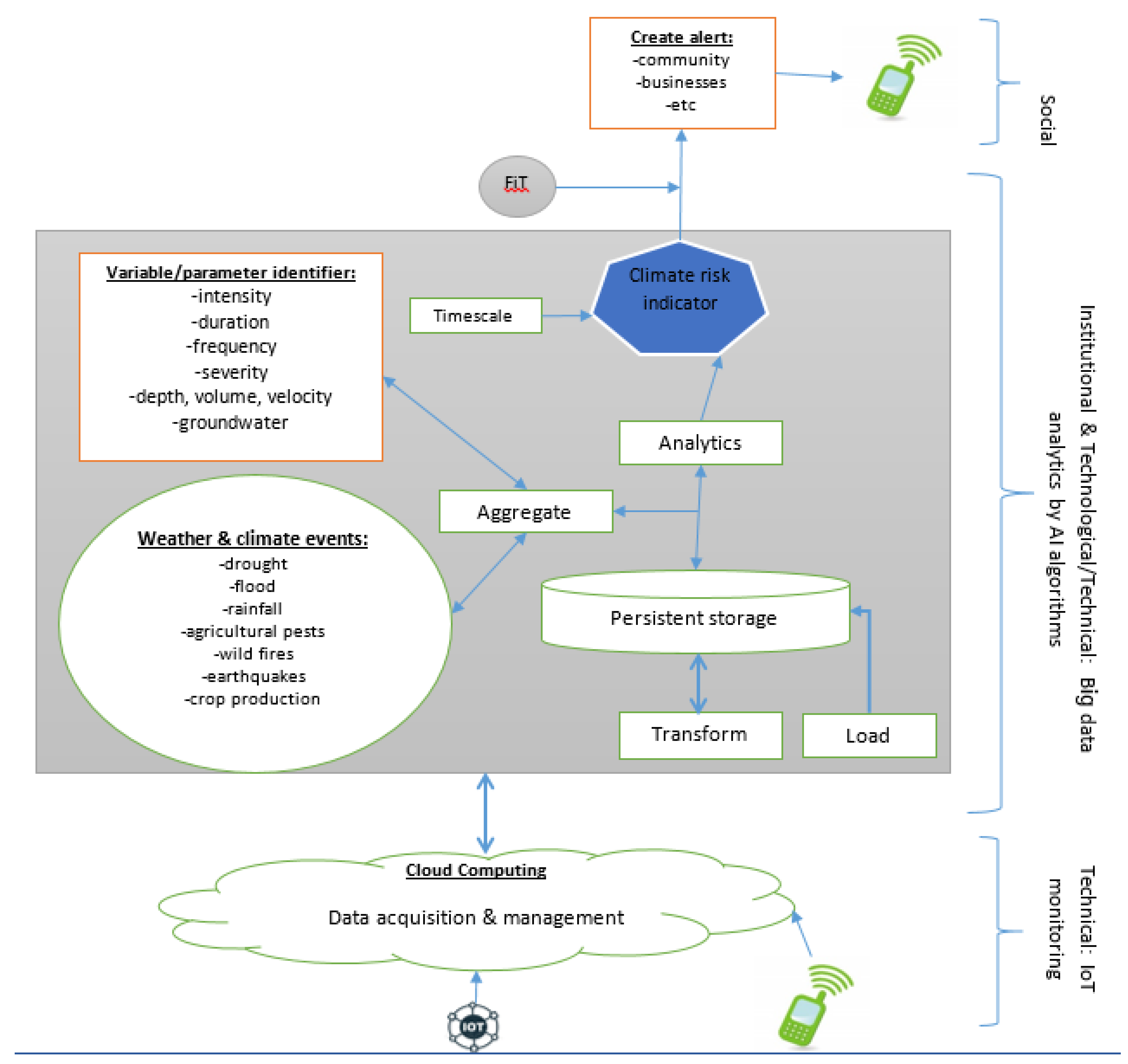
2.8. Application of 4IR Technologies in Early Warning Systems

Early warning systems appear to blend physical, biological, and digital systems. This blending of systems introduces the concept of cyber-physical systems, which require the fusion of digital, physical, and biological spheres and has been championed in many applications that require timely data acquisition and processing [104]. Cyber-physical systems are systems equipped with sensing capability, able to perform computation, control, and networking, where these capabilities are embedded into physical objects and infrastructure to facilitate internet connection. Another term associated with cyber-physical systems is the “Fourth Industrial Revolution” (4IR), which is creating the required technologies to support effective automation and integration of systems [105]. The technologies that have facilitated such integration include Artificial Intelligence (AI) and Machine Learning [106], the Internet of Things (IoT) [107], Cloud Computing [108,109], Big Data [110,111,112], Blockchain [113], 3D printing [114], Biotechnology and Robotics [115], and many more. Table 2 describes 4IR technologies as presented by [116].
Applying each technology or its combination creates resilience to ensure a timely response to climate events. For instance, the combination of sensors and AI in precision agriculture [118] and the use of AI and big data in detecting and predicting a pandemic. Organizing these individual technologies into functional EWS requires monitoring, analysis, value creation, and action. With monitoring, real-time data is collected from sensors and fed to the EWS. The AI models then analyse the streaming data from the sensor in near-real time. The 4IR technologies can rapidly evolve social-ecological systems, which calls for a multi-disciplinary approach to make such systems more relevant for policy and practice. Among the areas where 4IR technologies have been applied are monitoring waste treatment plants via AI, smart sensors, and other IoT technologies [119]; excess water to be traded via blockchain [120]; and monitoring waterways and large reservoirs via AI, IoT, and drones [121]. Real-time remote sensing technologies have been successfully used to analyse and predict adverse impacts on land degradation and pollution variables in water quality [122]. Though technologies such as cloud computing facilitates real time monitoring and prediction of climate related events [123], 4IR technology suggests that disruptive technologies can change business operations and impact society [124]. Thus, applying 4IR technologies in EWS could create a need for new data types and formats to help identify new elements of EWS [125]. Table A1 in the Appendix A presents the categorisation of 4IR technologies into the climate risk resilience framework. It also indicates the recent trends in 4IR technology applications to different aspects of the climate risk framework. The cyber-physical space has witnessed the use of technologies and tools for climate-events prediction. These tools can support EWS to analyse data captured from IoT devices and ensure effective monitoring of useful indicators for managing natural and man-made disasters. AI can support EWS to mine early warning signals from a dataset to identify climate-related event indicators [126]. These 4IR or “disruption technologies” facilitate the mapping of disaster areas captured in satellite imagery for targeted relief interventions [127]. For instance, satellite data is linked to ground data inputs from sensors, weather stations, and local communities through SMS-based platforms, which support the modelling and quantifying risks [10].
Furthermore, communication tools such as email, radio, TV, sirens, megaphones, and online services are used for warning information dissemination, thereby reducing human fatalities and saving property. While technologies and data required for resilience and sustainable development in southern Africa are not readily available, the adoption and utilization of these technologies and the coordination by stakeholders to effectively react to early warning messages compounds major challenges of EWS adoption. Furthermore, as more technologies (e.g., sensors) are widely deployed to facilitate disaster recovery planning, the scalability of the underlining IT infrastructure becomes another challenge [128].

3. Materials and Methods

The literature search was conducted primarily on the Scopus database because of its vast coverage; 1021 documents were exported for analysis. Articles published in the Scopus database have been peer-reviewed, adhering to research article quality assessment criteria. Thus, only peer-reviewed articles are subjected to bibliometric analysis. Literature search keywords are climate risks, resilience, climate early warning systems, 4IR technologies, climate hazards, and SADC. The search keywords constitute the research area for this study.
Bibliometric analysis is more rigorous as it explores and analyses large volumes of research and scientific data to effectively uncover emerging trends and intellectual structures of the specified research domains in the extant literature. Through this method, the academic output of researchers was measured and evaluated [129] to reveal the scientific knowledge of well-established research fields [130]. Bibliometric analysis helps to conduct a more structured literature review to identify research patterns. A software package called “Biblioshiny“, available on the R studio application, was used during this bibliometric analysis. This package provides the relevant web-based interfaces that enable visual analyses of the data collected from Scopus. The data processing capability of biblioshiny provides the specific trends on countries spearheading climate risk research.
The bibliometric analysis approach showed the scientific mapping and network analysis of academic research output from 2008 and 2022. Science mapping presents the relationship between research disciplines and documents from several authors to reveal the hidden themes in literature [131]. Scientific mappings also show the citation and co-citation analyses to help understand the research trends. Co-citation presents the analyses of intellectual and social structures in scientific research from the authors’ (co-authorship) perspective and the authors’ affiliations [132]. Network analysis provides network metrics, clustering, and visualization to help understand the relative importance of authors, their institutions, and countries, which might not be seen through publications or citations. Combining scientific mapping and network analysis presents the research domain’s bibliometric and intellectual structures. It is imperative to have a metric that can show an objective view of the bibliometric analysis result. Thus, a metric to provide such objectivity would indicate the degree of centrality (that is, relation on research in a network), PageRank (that is, publication impact), eigenvector centrality (nodes interconnectedness), betweenness centrality (nodes interrelation with unconnected nodes), and closeness centrality (how close nodes are with another).

4. Results

The bibliometric analysis results are presented and discussed to understand the issues of climate risk and resilience, focusing on early warning systems. The section commences with the bibliometric analysis results of the database.

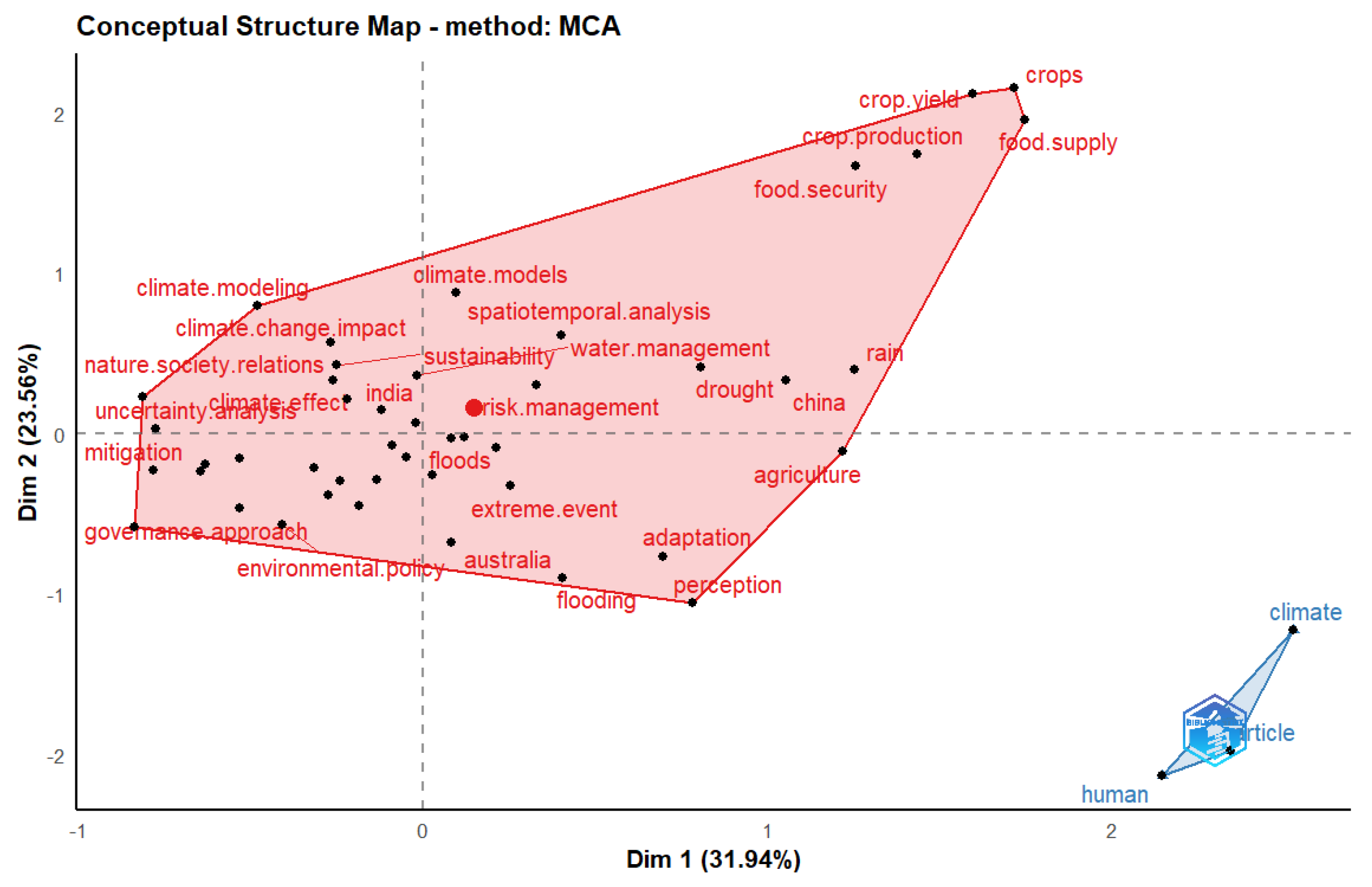
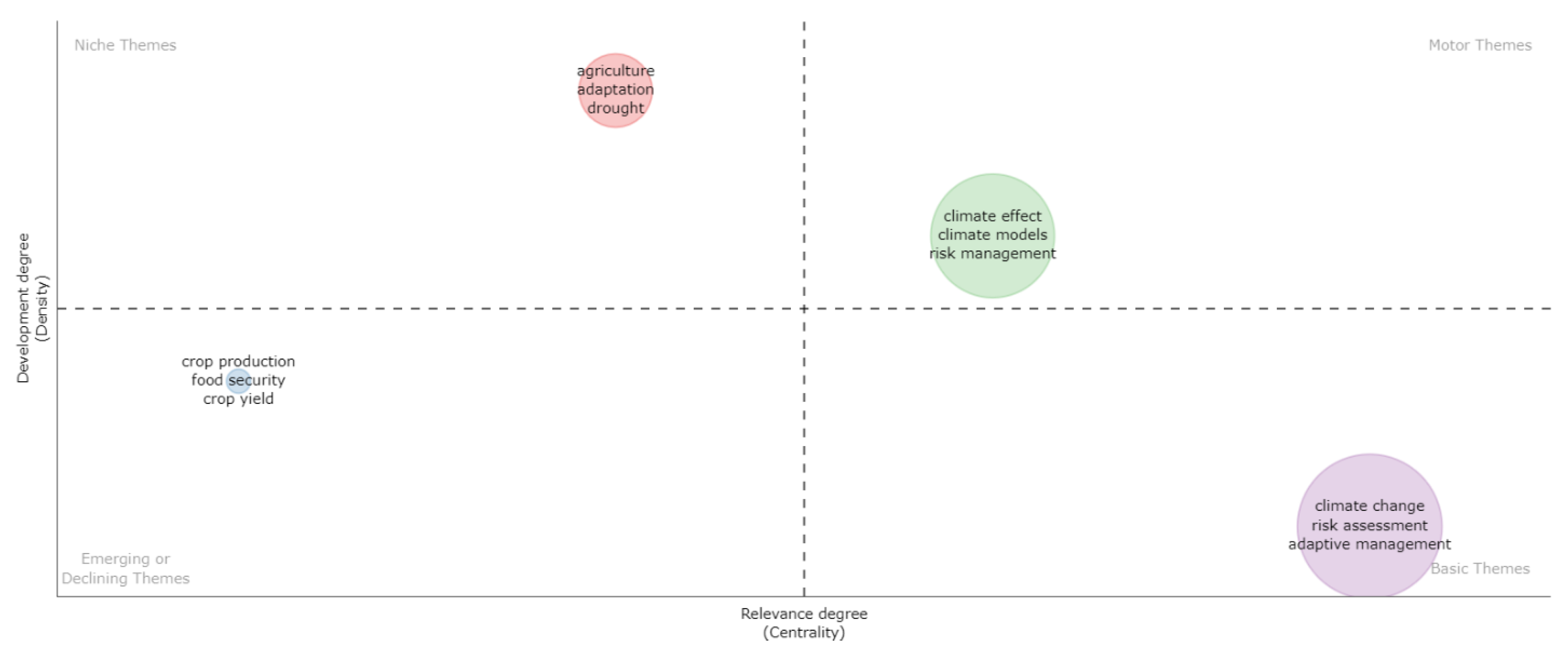
4.1. Bibliometric Analysis Results

Initially, a search string was used to extract data from the Scopus database. Bibliometric analysis results were presented as bibliographic statistics of documents, scientific production, most frequent words in the document, thematic evolution, Three-fold plot, chronological mapping of the trending topic, conceptual structure map, co-occurrence network, and bibliometric historiography. Figure 1 presents the bibliographic statistics of the data exported from the Scopus database between 2008 and 2022.
Figure 1 shows the bibliometric statistics indicating the timespan, sources, number of documents, authors, etc. This statistical overview of documents from 262 sources helps synthesize the research domain’s scientific analysis. Figure 2 shows the scientific production concerning citations retrieved from 2008 to 2022. Biblioshiny was used for the bibliometric analysis plots because it provided the web interface for bibliometrix.
Figure 2 shows that the scientific production of articles increased gradually from 2008 to 2021. Afterwards, article production declined steeply from 2021 to 2022, which could be attributed to the COVID-19 pandemic. Table 3 shows the detail annual scientific production of articles.
Table 3 indicates that the number of articles in 2021 and 2022 are 197 and 125, respectively. It is evidence that the number of articles assumed an upward yearly trend, suggesting a growing author research interest. The citable years of an article in 2008 and 2009 were 14 and 13, respectively. The mean total citation per article in 2008 and 2009 was 103.00 and 93.18, respectively. The mean total citations for 2008 and 2009 were 7.36 and 7.17, respectively.
Figure 3 shows the top 10 most frequent words in the documents, which include climate change (838), risk assessment (509), adaptive management (215), decision making (162), vulnerability (160), climate effect (158), drought (98), risk perception (98), climate models (92), and the United States of America (90).
Figure 3 shows that most authors’ top concerns are climate change (838) and risk assessment (509). This suggests that “climate change” is the most frequent word in the dataset. Further analysis was required to understand the underlying structures in the dataset; thus, the Multiple Correspondence Analysis (MCA) was conducted. This analysis represented the data set as points in a two-dimensional space. The strength of association applied in constructing the bibliometric map allowed various scientific maps to be prepared, showing the dynamic nature of the data obtained from the scientific research. Figure 4 shows the conceptual structure map based on the Multiple Correspondence Analysis (MCA) method.
Figure 4 shows cluster 1 (red colour), consisting of themes including extreme events, adaptation, drought, climate models, climate modelling, risk management, climate effect, and many more. Cluster 2 (blue colour) is the most significant, consisting of themes including humans and climate. The conceptual structure puts data with multiple variables onto a low-dimensional space, creating a two-dimensional graph with plane distance to show similarity between themes. Themes or keywords approaching the centroid of a cluster indicate that they have received a lot of attention from research [133]; those near the edge are topics that have received minimal attention or were incorporated into other topics [134]. The thematic analysis clusters authors’ keywords and their interconnections, thereby providing the themes, characterized by density and centrality. The density is shown on the vertical axis, while centrality is also on the horizontal axis. Centrality represents the degree of correlation among different topics; density also measures the nodes’ cohesiveness. Thus, the density and centrality measures show how well a topic is developed. Moreover, the higher the number of relations in a node with others in the thematic network, the higher the centrality and importance.
Figure 5 provides the thematic evolution plot divided into four quadrants: driving or motor themes, underlying or basic themes, specialized or niche themes, and disappearing or emerging themes.
Notably, from Figure 5, the motor themes remain the climate effect, climate model, and risk management. Themes such as climate change, risk assessment, and adaptive management are the basic themes and are very important for field development. Themes such as agriculture, adaptation, and drought in the niche quadrant represent a marginal contribution to the development of the research domain. The finding in the niche themes suggests potential topics that need to be more connected to climate risk resilience. Thus, thematic analysis suggests developing niche themes such as agriculture, adaptation, and drought to establish more ties with climate risk resilience.
Figure 6 provides an overview of the trends in literature per year from 2008 to 2022. In 2012, trending topics included policy integration, climate information, and sub-Saharan Africa. In 2019, trending topics were focused on adaptive management, risk assessment, and climate change as shown in the cluster with larger circles in blue. Thus, a larger circle represents more authors are focused on those trending topics. In 2022, trended topics include climate risk. By using the nature of the cluster in terms of cluster size, it can be deduced that climate change, risk assessment, and adaptive management were the trending terms in 2019. Comparatively, this cluster size is bigger than others. Meanwhile, climate risk was trending in 2022, suggesting a growing research interest possibly because of the likelihood that it could threaten human lives when not given the needed attention. Contrarily, adaptation strategies trended more heavily in 2017 than in 2022, which suggests that adaptation strategy needs to be intensified to help manage climate risk impact in general.
Figure 7 shows a Three-fold plot specific to Topics (TI_TM), author country (AU_CO), and keywords in the top 10 rankings. The top 10 topics (climate, risk, change, adaptation, and many more) are associated with the top 10 authors from the USA, United Kingdom, Australia, Germany, China, India, South Africa, Netherlands, Italy, and Canada. South Africa is the only SADC member in this rank. Again, the top 10 keywords from these AU_CO are climate change, climate risk, adaptation, resilience, etc.
Figure 8 is the co-occurrence network, showing a graphic visualization of the relationship between words and concepts clustered into Cluster 1 (red) and Cluster 2 (blue). Table A2 in Appendix A shows the metrics of the co-occurrence network on the degree of centrality, betweenness centrality, closeness centrality, and PageRank.
Table A2 shows the co-occurrence network where climate change is the focus of most publications in the Scopus database. The betweenness values for climate change, risk assessment, and adaptive management are 180.6303909, 83.62965584, and 26.99226282, respectively. The highest betweenness value for climate change (180.6303909) in cluster 1 indicates the research focus of most publications. The same closeness value (0.020408163) was recorded for climate change, risk assessment, and adaptive management. This closeness value indicates the relative ease for these nodes (climate change, risk assessment, and adaptive management) to carry information effectively. The PageRank value for climate change (0.126363441) shows that publications focusing on climate change influences most research in highly cited publications.
Figure 9 shows the authors’ most-cited historical research evolution in the Bibliometric historiography graph.
Figure 9 shows that historiography, where the top of the graph shows the concern for “water resources”, was considered extensively by Turner, 2014 and John, 2022. The node at the bottom of the graph shows that climate change publication occurs relatively more frequently in the early work by Conway, 2019. This historiography is detailed in Table A3 (see Appendix A), showing the authors and research titles. In Table A3, LCS shows an article’s number of citations within the citation network. In comparison, GCS shows the total number of article citations in the Scopus database regardless of its inclusion as a connected component on the citation network. Articles with high GCS are recognised as seminal or influential papers in the body of knowledge [135]. GCS identifies the articles that represent the basis of a research domain used by authors to develop their contribution, including citations from the entire Scopus database, even if these citing articles were not selected through the keyword search.

4.2. 4IR Technology in EWS

4IR technology is crucial in building a climate risk resilience framework because it harnesses different technological solutions for changing climate conditions. A thorough literature review shows that the accuracy of climate risk prediction and its correctness help in a timely response strategy. Climate model is one of the top 10 most frequent words (Figure 3), and it is evident that 4IR technologies is not among the most frequent words, even though it can facilitate data sharing among different climate models. It can be identified that geographical information systems (GIS) and climate information trended in 2011 and 2012, respectively (Figure 6). The fact that the “data set” trended in 2014 (Figure 6) suggests that there were limitations in obtaining data for climate models. Though the bibliometric analysis shows climate risk trending in 2022 (Figure 6), the result could not be associated with SADC member states. Again, it is shown in Figure 5 that 4IR technology is not within any of the quadrants in thematic evolution, thus suggesting a lack of 4IR technology importance. Furthermore, without data on climate risk knowledge and monitoring, the climate risk prediction might introduce false-negatives or false-positives, raising false warning messages to create false responses. The thorough review of the literature summarises the characteristics of the 4IR-based design of EWS as follows:
(a)
Transparency is when the information is always provided to everyone for public discussion or scrutiny.
(b)
Integration: AI models could support automation and systems integration between communities and society, thereby creating flexibility in operating EWS locally.
(c)
Human capacity: Appropriate staffing is mandatory for all EWS, with the expertise of the personnel to correspond with the vulnerability/vulnerabilities and hazard(s) of concern.
(d)
Continuity: An EWS must operate continually, even though the hazard of concern may occur intermittently or rarely.
(e)
Triggers/Patterns: Engaging the community to define warning messages helps define triggering mechanisms and patterns for sending warning information. A trigger could be anything from a quantitative indicator to an anecdotal comment. A regular and frequent pattern should keep people engaged and familiar with the warning messages but not irritate people.
(f)
Accuracy: This is the preciseness of climate risk prediction. AI models could ensure accuracy and timeliness in monitoring, reporting, and predicting climate risk.
(g)
Timeliness: For a warning to be useful, information must provide enough lead time for those at risk to decide and react accordingly.
(h)
Data variability: In the context of big data, data variability refers to the number of inconsistencies in the data or the inconsistent speed at which big data is fed into a centralized database by IoT devices connected to EWS.
The review of the literature also suggests that 4IR technologies (Table A1) can be categorized into different aspects of an EWS: Risk knowledge acquisition and assessment (K), Monitoring (M) and Prediction (P), and Warning information dissemination (W), and can be summarized as follows.
  • IoT has been applied extensively to data capture to build risk knowledge, monitoring, and warning information about different kinds of climate hazards [136,137,138]. Additionally, smartphone-embedded sensors serve as a tool to monitor natural disasters anytime and anywhere. Furthermore, this enables pre-identification of communities affected to ensure the placement of broadcast systems.
  • AI has been applied extensively to predict climate risk [126,139,140].
  • Big data and cloud computing for monitoring and predicting aspects of EWS [141,142]. This computing environment supports data integration from heterogeneous sources for system-to-system linking.
  • Blockchain has been applied for flood risk quantification to provide an appropriate insurance strategy [143,144].
  • Drone for surveillance to assess the impact of disaster within a location [145,146]

4.3. Climate Risks and Hazards in the SADC Region

Climate risk emerged as a trending topic (Figure 6) in 2022; however, South Africa is the only country in the SADC region, as shown in a Three-fold plot (Figure 7), to be included within the top 10 ranking of author country (AU_CO). This suggests intensifying research on climate risk resilience efforts in the SADC region. Notably, the SADC region is affected by four main climate risks: drought, flood, fire, and storms. Drought is widespread and the most deadly and costly natural disaster; some initiatives include the Southern Africa Drought Resilience Initiative (SADRI). Furthermore, SADC member states have periodic extreme weather conditions, such as cyclones, floods, and droughts, which have intensified under climate change.

4.4. Design Approach to Climate Risk and Resilience

The reviewed literature suggests a need to support community resilience to climate-driven shocks. In this regard, the approach to building resilience within the SADC region could focus on three dimensions (see Figure 10): Social, Institutional, and Technological/Technical (SIT). The dimensions focus on what to consider before using the climate risk resilience framework as it identifies the salient factors from the perspective of societal and technological products, including institutional factors.
The SIT dimensions for EWS are detailed in Figure A1 (see Appendix A), showing the IoT monitoring framework, big data analytics, and Social.
The monitoring framework manages different IoT devices/sensors/mobile devices connected to capture/acquire climate event data in real-time. This could help resolve the challenge of linking specific climate events to a location.
A mobile device connects to the monitoring framework to resolve the manual climate data capture to allow reporting of climate events. A network traffic controller could manage the traffic in the network for smooth processing of the climate-related data. A Software-Defined Network (SDN) can provide a programmable interface to handle incoming big data due to its dynamic and scalable nature [147].
Big data analytics performs different kinds of analytics on weather and climate events, including parameter/variable identifiers, climate risk indicators/indices, and data aggregation. It centralizes data to avoid silos and processes data in real-time with AI algorithms. AI algorithms could classify climate events with the related variables/parameters required to forecast a climate event at the desirable level of climate risk. Again, it could segregate communities affected by climate impact for appropriate responses. Moreover, the choice of climate risk indicator/index is based on the characteristics of the weather event and the “ease of use”. It is suitable for particular climate events, data availability, and the computational resources needed to implement them. These indicators/indices are categorized into meteorology, hydrology, remote sensing, and soil moisture [148]. The climate risk indicators/indices comprise drought, crop production, flood, agriculture pest, and many more models. Data aggregation, which AI supports, helps find, collect, and organise climate data for a specified climate risk analysis. Timescale indicates whether the forecast is daily, weekly, or monthly. Aggregate is where data are gathered to apply the required weighting of an indicator.
The Forecast information Translator (FiT) translates the forecast information to the target end-users. Finally, an alert is created and sent to the community/business end-users via text message.

5. Discussions

The scientific mapping indicates that climate change (838), risk assessment (509), and adaptive management (215) are the most frequent words in the research publications. Trending topics are climate change, risk assessment, and adaptive management. the outcome of this study reveals that topics related to climate risk were of interest to researchers from 2021 and 2022. Three-fold plot on topics (TI_TM), author country (AU_CO), and keywords for top 10 ranking show topics on climate are more associated with authors from countries such as the USA, United Kingdom, Australia, Germany, China, India, South Africa, Netherlands, Italy, and Canada. Thus, it is revealing that though this study focused on the SADC region, South Africa is the only country in the SADC region found within the top 10 ranked countries, thus suggesting a research gap. Also, literature reveals that countries such as Madagascar have integrated early warning action into national development strategies [48]. Since most SADC regions are not among the top 10 ranked countries, the SADC region needs to support climate risk research. At the same time, the thematic analysis suggests that niche themes, such as agriculture, adaptation, and drought, are potential topics that need to be more connected to climate risk resilience. Thus, more effort is needed to develop niche themes to establish more ties with climate risk resilience.
Existing multi-hazard EWS in the SADC region focuses on flood and drought monitoring and assessment components without drought forecasting components, thus leading to reactive rather than a planned intervention. Some SADC member states (e.g., South Africa) have disaster centres to inform on extreme weather events and their likely effects; however, the human capacity required to use monitoring systems to identify the hardest-hit disaster areas might often be unavailable. In some instances where human capacity is available as volunteers, they manually capture climate data on recording instruments, which are later sent via courier to regional offices for further processing. Thus, the intensity or sparse nature of the disaster, at the time, might require more volunteers. Therefore, there is a possibility of high human involvement in manually observing, capturing, and couriering climate-related data (e.g., rainfall) to the South Africa Weather Station (SAWS) office.
The bibliometric analyses results could not show any information on climate risk, 4IR technologies, and EWS that could be linked to SADC member states. Thus, we require further thorough literature reviews to answer the question: how do EWS and emerging technologies facilitate climate risks to ensure resilience development within the SADC region? The outcome suggests that the integration of 4IR technologies in the design of EWS adds some innovations to the EWS in support of building resilience. The 4IR technologies provide a set of capabilities required to generate the required data to assure the robustness and sustainability of EWS. Additionally, 4IR technologies could help resolve the weaknesses in EWS regarding system automation, real-time data collection, and transition to where the data are required. While the ease of use of 4IR technologies may be a challenge, especially the poorly-resourced smalls scale farmers and generally rural poor who are a majority in SADC, it can facilitate the sustainability of EWS for the SADC region through the capabilities of IoT, AI, Big data and cloud computing, drone, and blockchain technology [149].
Though the role of blockchain technology in EWS is blurred in terms of how it creates or ensures transparency in the operations of EWS, it can assure communities’ trust in the source of information, i.e., from the national to the local level. Similarly, it could ensure decisions from the local level are cascaded to the national level without data being altered, thereby facilitating decentralisation and mainstreaming the agenda of SADC member states. While embedding technological innovations and advanced analytics such as AI/ML in EWS has great potential, the inherent technical challenges at national, regional, and local levels in operating EWS including data collection and integration, management, and warning dissemination and communication networks act as impediments. Additionally, inadequate EWS coupled with limited investment and weak institutional and technical capacity implies that use of EWS to ensure that the impacts of any climate risks at the local level are well captured and reported to the national authorities has reached maturity. Blockchain technology can facilitate risk quantification within the public regulatory framework to plan insurance packages for affected communities [144]. It can be suggested that there is a lack of coordination and collaboration mechanisms, from the national to local levels, to ensure the application of appropriate tools and infrastructure for weather-related events. EWS provides inadequate information to help reduce climate risk impact at a local level [150].
EWS with associated 4IR technologies might be prone to system failures [151]. EWS need to be more flexible in adapting to the different thresholds of climate risks. This can be ensured by using AI in EWS to facilitate learning from historical or real-time data in order to adapt and accurately interpret climate risks for appropriate response.
Though climate risks measured on metrics might not be the best indicators of real resilience, blockchain technology might ensure that digital records captured at the local level provide some certainty. By linking several metrics in EWS, there is a possibility that efforts might be focused unduly on one thing or create bias; as such, further research is required to create a comprehensive list of factors for the metrics in EWS. Though this might be complex, the key issue is how to build resilience through the interaction of multiple indicators. For instance, while the SHARP framework focuses on elements/properties considered adequate in risk assessment, the logical validity of indicators/indices might provide some level of objectivity on the type of indicator to use. AI algorithms ensure intelligence is transferred to computers and/or robots through sensors that perceive the surrounding environment in order to take appropriate action. Thus, AI could provide, to an extent, a logically valid indicator for EWS. Since the SADC region is challenged with creating coordination toward effective planning and managing climate risk uncertainties among member states [61], blockchain technology can serve as a tool to create a distributed ledger that might help create much-needed regional coordination and collaboration [18,152].
Furthermore, big data and cloud computing could ensure that varying sectoral data needs are adequately captured and processed by 4IR-based enabled EWS. In this regard, AI technologies are anticipated to reduce constant reliance on human capacity. However, constant staff training at the local level is still relevant to enhance technical know-how on using AI-based EWS. Though the lack of expertise in 4IR technical know-how may be a challenge, inadequate integration of scientific knowledge into EWS design and its operation is part of the challenges. Given the geographical coverage of the SADC region, there could be a broader engagement in designing warning messages in different languages to empower people, especially farmers, to take appropriate action. The response capacity of an EWS is how well it is integrated within social structures, especially concerning potentially marginalised communities [153]. The sustainability of community engagement in EWS could be achieved through constant training and dissemination of scientific knowledge. Information technology and commonly accessible mobile devices can help to sustain community participation, even if it means disseminating the warning information in a local language for easy understanding. However, the lack of a supportive framework to integrate and create an interactive community-centric EWS has made this study more relevant.
Consequently, this research provides the required framework for the design of EWS for all SADC members. SADC member states ideally require IoT, cloud computing, and a big data framework to effectively record climate events, thereby helping to address the challenge of assessing the unknown impacts of climate events at a local scale [154]. In these regards, the frequency of natural disasters has created repeated destruction and disruption of infrastructures, affecting millions of people’s livelihoods [155]. Though it is estimated that 60% of the population in the SADC region uses mobile devices, there is still limited access to mobile phones and/or internet access, which might reduce accessibility to climate warning information [156]. The impact of climate disaster has no boundary; therefore, EWS facilitates resilience by ensuring information technology capabilities are utilised to capture climate events, the relevant data is processed, and appropriate warning information is disseminated to vulnerable communities.

6. Limitations, Policy, and Practice Implications

The opportunities presented by the 4IR require policymakers or climate-related agencies to re-prioritize EWS over other operational risks. The 4IR could transform the existing EWS of countries, thereby calling for new methods and processes and broad stakeholders’ consultation, both public and private sectors, to academia and civil society, for a global integrated and comprehensive policy to ensure the realization of the 4IR technology use in EWS. Robust climate prediction and accurate weather forecasts are critical in making the right adaptation policy and investment decisions. However, many developing countries do not have the resources to sustain the human, institutional, and infrastructure capacity required to provide high-quality weather forecasts, early warnings, and climate information. Since EWS exist at different levels, different technologies, human capacities, and funding may be required. The findings suggest the need for policy convergence across the social, institutional, and technology industries to create technological reforms toward an effective EWS within the SADC region and Africa more broadly.
Our findings require policymakers and disaster risk practitioners to define sets of metrics to help assess their country’s vulnerability and strategy for climate events. Also, to the policymaker, it would inform which stakeholder should be engaged in the response efforts. Research capacity is needed to expand EWS to niche themes in agriculture, adaptation, and drought to establish more ties with climate risk resilience in southern Africa.
This study presents a framework (see Figure A1) for addressing aspects such as climate user interfaces, climate service information, prediction, and capacity development of the National Framework for Climate Services (NFCS) in South Africa, which is premised on the Global Framework for Climate Services (GFCS) [157]. Specifically, this study calls for policies integrating 4IR into early warning systems to enhance the application of science-based climate monitoring and prediction to reduce the degree of occurrence of severe weather events that have increased in recent decades.
An effective EWS ensures a quick response by disaster risk managers to an affected community. The findings of this study can be useful in formulating strategies to guide practitioners in re-modelling EWS within the SADC region. This re-modelling would lead to better delivery of climate-related information to people, thereby minimising the impact of climate disasters. The benefit of this re-evaluation or re-modelling to the disaster risk personnel is the ease of receiving timely and accurate information in lead time to enhance emergency response. Furthermore, lives and properties could be saved. Though African countries may differ in certain aspects, they exhibit some similarities in processes with other professional counterparts in the SADC region [158]. These processes and characteristics, built into EWS (Table 1), must work with related 4IR technologies (Table 2). This highlights the need to bridge the gap between soft applications that can be put on mobile devices and create system integration and transition approaches toward an effective EWS. Despite the high mobile penetration, the unaffordable data cost in the SADC region, which limits mobile smartphone use, could be addressed through policy intervention that reduces the data cost. Thus, government and industry can work together to reduce data costs or provide zero-rated EWS-related apps and websites. The current best practice of governments to zero-rate certain apps or websites is a good practice. This research calls for policymakers to extend such good practices to climate-related applications. Furthermore, the government can release more bandwidth, allowing mobile network providers to reduce data costs.
Meteorological, hydrological, and climatological climate hazards have taken a heavy toll on the SADC region and its governments. This calls for harmonising technical expertise from institutions across the SADC region to create a more robust functional EWS that integrates with emerging technologies. Unfortunately, the underlying frameworks of these emerging technologies (e.g., IoT, drone, blockchain, etc.) are very diverse, bringing to the fore the challenge of the technology framework’s interconnectedness.
This research highlighted some weaknesses in designing and operationalising early warning systems. The design weakness includes the lack of participation of communities in the design of EWS, integration of local knowledge systems, institutional collaboration in identifying hotspots of climate hazards, and integration of new technological devices with existing EWS. This calls for trans-disciplinary approaches that involve all stakeholders (government, industry, and society) to co-design, co-develop, and co-implement EWS. One of the approaches to address the lack of participation of communities is establishing climate service awareness volunteer groups in communities with the mandate to deepen community participation in the design of EWS. Community leaders should be involved in these groups to increase local community participation. Representatives of climate service providers can oversee the design with their technical expertise. Alternatively, establishing campus-based climate awareness clubs in Higher Educational Institutions can increase participation in the design of EWS and the use of climate service information. Despite these design weaknesses, there has been some positive intervention to help profile the climate risk information of SADC member states [62,63], which might lead to the creation of useful technical expertise required to support the operation of the SIT model. The findings revealed a lack of supportive interaction, integration, and community centred EWS frameworks. There is a need for capacity building through training to support community centred EWS to improve response capability.
The choice of only the Scopus database, because of its wide coverage, is a limitation of this study. Other constraints include the number of studies reviewed and selected, reliable data that fit the thematic areas, articles/reports not written in English, and citing prior articles not within the period considered in this study. Only published articles were considered, and many reports or operational systems might not have been published. Thus, acknowledging these limitations provides future direction, as they might have valuable information to help generalize the findings of this study. Notwithstanding these limitations, the study’s findings are still relevant and useful.

7. Conclusions

There is a glowing body of knowledge demonstrating that the SADC region continues to increasingly be barraged with various multi-hazards, including natural hazards such as geological (earthquakes), hydrological (floods), meteorological (e.g., droughts), as well as climatological hazards (e.g., heat waves). As a result of these omnipresent multi-hazards, many initiatives of early warnings are abound across national institutions e.g., NMHSs, NDMC, Regional Centres and even WMO Regional Specialised Centres, RECs e.g., SADC CSC, current operational weaknesses of these EWS which often lead to ineffective Early Actions (anticipatory action) exists. Some of the reasons include lack of enabling national legislation, defined roles and responsibilities, poor outreach to vulnerable communities, differing levels of development amongst Members in the SADC region, poor funding of national institutions by government, lack of infrastructure, tools and capacity building. The need to help communities prepare for and respond to these disasters has even been elevated to the global scale: see the “Early Warning For All Initiative (hereafter EW4AI)”, that was launched by the UN Secretary General in November 2022. Underpinning the EW4AI is a call for effective Multi-Hazard Early System that ought to have applications in risk management and disaster preparedness to help save lives and minimise the potential impact of disasters. SADC member countries are expected to unanimously support this initiative.
It is against this background that this study systematically reviewed published work on EWS for climate risk resilience development and highlighted the issues of concern in building climate risk resilience approaches. The review highlights the importance of the Social, Institutional and Technological/Technical dimensions for consideration in the design of EWS, which are relevant considerations for EWS design and implementation. The characteristics of EWS are triggers/patterns, continuity, flexibility, human capacity, integration, transparency, accuracy, timeliness, and data variability.
From the Technological/Technical dimension, blockchain technology could be marginally adopted or used in EWS. Designing technologically based solutions can increase the resilience of SADC members; however, the lack of community engagement and human capacity can impact the usability of any EWS in general. For instance, customising climate information systems generally increases climate resilience in agriculture. However, the inadequacy of climate information from the meteorological observation network to support climate risk management may be challenging for most developing nations. Thus, it is necessary to fund meteorological agencies to acquire the needed 4IR technologies, which could help generate climate data.
The study suggests that the determination of multiple indicators for metrics is necessary and should be sufficiently linked to EWS to facilitate resilience. This linking could be achieved using AI algorithms. Also, combining the characteristics of IoT devices/sensors, big data and cloud computing is a step in the right direction towards building the backbone of an EWS for the SADC region. Furthermore, 4IR technology applications may be used to encompass various climate-related issues.
Different climate events have different characteristics, making it complex to model the development of EWS. From an Institutional dimension, it is relevant for the SADC region to have a supportive framework for an integrated and interactive community centric EWS. Again, the capacity to support EWS in various communities needs ongoing training. The Social dimension includes community participation in designing warning information. It is relevant to mainstream EWS into the SADC region’s developmental agendas and encourages the use of climate information services within the SADC region. Though the research focused on the SADC region, the results highlights can be generalised within the African context due to the underlying challenge of poor infrastructure, people living in informal settlements, and lack of basic public services, to mention a few. It is imperative to reduce climate-related fatalities in Africa and minimise the food insecurity, ecosystem destruction and loss of lives on the continent of Africa. This study also calls for the SADC region to proactively and effectively strengthen its early climate risk warning systems to help and enable proactive responses to multiple weather variables like the recent extreme heavy rains, which hit eastern, western and southern Africa, triggering huge crop and livestock losses, landslide and floods [24]. Again, this study calls for the use of long-range climate forecasts models because of the benefit in ensuring a sustainable resource management (e.g., land, water, and forest) that can economically impact on lives. SADC members should ensure an effective maintenance of meteorological equipment to facilitate timely data capture and climate prediction. This can be achieved when adequate funds are allocated to the established meteorological agencies. Thus, this research highlighted some weaknesses in the design and operationalization of early warning systems, including the in-active participation of communities in the design of EWS, institutional collaboration in identifying hotspots of climate hazards, and integration of new technological devices with existing EWS.

Author Contributions

I.E.A.—idea conceptualization, Methodology, software, Writing-Original draft; S.S.—Writing-Reviewing and editing; M.M.—Writing-Original draft; J.B.—Writing-Original draft; T.M.—Writing-Reviewing and editing, funding acquisition, supervision. All authors have read and agreed to the published version of the manuscript.

Funding

This research was funded by the Government of Flanders through the Integrated Climate-Driven Multi-Hazard Early Warning Systems (ICMHEWS) Project between the South Africa Weather Service (SAWS), the Central University of Technology (CUT) and the University of KwaZulu-Natal (UKZN). The Adaptation Fund is acknowledged for funding through the uMngeni Resilience Project. The APC was sponsored by the Centre for Transformative Agricultural and Food Systems (CTAFS) of the University of KwaZulu-Natal.

Data Availability Statement

Anonymised data are available by contacting the authors.

Conflicts of Interest

The authors declare no known competing financial interests or personal relationships that could have appeared to influence the work reported in this paper.

Appendix A

Table A1. Categorisation of “Fourth Industrial Revolution” (4IR) technology in climate risk resilience framework.
4IR TechnologyAuthorsYearResearch Focus/Proposed ApproachAspect of Climate Risk AddressedAdvantages
IoT[136]2022IoT schema interfaced with a website for a selective alert. M, WEasy to set up by a non-technical person; ease of roaming on multiple networks without the need for a static IP address
[137]2015Practical deployments of semantic EWS for geologic hazardsM, W Support service interoperability; easier sensor and data source plug-and-play
[138]2022Integrating Fog/Edge layer in IoT architectures and defining requirements of EWS for different natural disastersM, W
[159]2017IoT like “Sensor Web Enablement Framework (SWE)” and Message Queue Telemetry Transport (MQTT)” for a natural disaster. M, WUse of smartphone-embedded sensors to monitor natural disasters anytime and anywhere
[160]2021IoT-based geohazard monitoringM, WMonitor indicators, including the three-dimensional
surface displacement, rainfalls and ground cracks, and then data are transmitted by 5G communication.
[161]2021Technical feasibility of the use of smart meter for IoT-based Earthquake Early Warning Platform (EEWP)M, W-
[162]2021Use of “micro-electro-mechanical systems (MEMS)” sensors and IoT (e.g.,
(Long Range (LoRa)) communication standard for local-scale landslide EWS in informal settlements
M, WSuitable for local scale EWS in informal
settlements.
[163]2021Role of IoT in disaster management for different kinds of disasterM-
[164]2020Using the Internet of Things (IoT) to provide early warning allows remote controlling and performs data analysis and knowledge building.MIt can be adapted to evaluate the performance of a disaster response system under uncertainty.
[165]2022Secure transmission of early warning to facilitate intelligent sensing of information using the Internet of ThingsMThe security mechanism is suitable for open and dynamic IoT sensor networks.
[166]2022Natural disaster management using social networks integrated with the Internet of ThingsMEnables pre-identification of communities affected to ensure placement of broadcast systems.
AI[139]2019Application of AI to analyse images and predict possible flood locationsPDetermines rainfall characteristic parameters in the two-dimensional space; combines IoT equipment and CCTV real-time image for real-time prediction
[140]2021AI algorithm that ensures the selection of optimal parameters and setting of thresholds for early warning system alerts.PLeverages existing warning system for additional hardware
Sensors can be integrated with existing EWS to generate additional data flow to select optimal parameters for EWS alerts. Thus solving the downscaled global models for early warning systems.
[126]2020Overview of AI-based machine learning techniques and EWSK-
[167]2022AI-based approach for hail weather areas recognition. The method is based on faster region-based convolutional neural network deep learning.P-
[168]2022AI that analyses satellite images and crop growing conditions to predict crop yield and prevent crop failuresM, P-
[151]2022The concept leverages big data analysis and AI to enhance existing Early Warning Systems (EWSs) for detecting systemic risk.P-
Big data and cloud computing [141]2021Managing sustainability climate issues through big data analytics, thereby enabling the integration of heterogeneous data and system-to-system linkingM, PEnables data integration
[147]2020Geological data collected from the monitoring station and transmitted to the cloud server via GPRS DTU to build a dynamic website displaying earning details and predicting geological disasters.PEasy to access cloud platform-for geological hazard analyse causes.
Blockchain[143]2019Accelerating climate actions through blockchain application to climate change mitigation, adaptation, and financeK, P-
[144]2021Quantification of flood risk mitigation measures to ensure resilience using blockchain technology from an engineering perspectiveKEnables public authority to deal with flood risk within a regulatory framework
Drones[145]2021Use of drones by technical experts to undertake climate risk assessment and mapping of the location K-
[146]2020Use of drones to improve climate resilienceK-
Note: Risk knowledge acquisition and assessment (K), Monitoring (M) and Prediction (P), Warning information dissemination (W), and Response capability (R).
Table A2. Co-occurrence network metrics.
NodeClusterBetweennessClosenessPageRank
climate change1180.63039090.0204081630.126363441
risk assessment183.629655840.0204081630.091879763
adaptive management126.992262820.0204081630.055539281
decision making19.1350752960.0188679250.034348997
vulnerability19.727214910.020.037852789
climate effect113.423364450.020.039498787
risk perception14.1184599470.0188679250.025350686
climate models14.9661153920.017543860.026292608
united states12.2054628220.0178571430.019883166
environmental risk14.0375190850.0196078430.022457882
environmental policy12.5720872430.017543860.02112796
risk management13.1654374190.0188679250.022168313
sustainable development11.9132803230.017543860.015860447
adaptation11.9335328950.017543860.018957926
uncertainty analysis11.3144448890.0153846150.016699269
extreme event11.7411956690.0166666670.016683781
stakeholder10.9524844820.0156250.015087685
perception11.3237802450.0163934430.016231361
water management10.4770059080.0144927540.010564123
climate modeling10.5907018170.0151515150.012113738
disaster management10.2104187260.0144927540.01136782
governance approach10.2448323960.0138888890.011431645
australia10.3716277090.0149253730.010675619
india10.1531100970.013698630.008501117
sustainability10.3727752770.0144927540.010538253
climate change adaptation10.5454886460.0151515150.012719564
water supply10.1450678030.0135135140.009286521
flooding10.2416006790.0142857140.010262234
floods10.2086374680.013698630.010278523
mitigation10.1479715740.0135135140.009670997
developing world10.0891548130.0133333330.008678562
policy making10.1690186330.0140845070.009596225
strategic approach10.3977832170.0151515150.010983937
environmental economics10.0992018520.0126582280.008521908
nature-society relations10.1694153430.0133333330.010257973
climate change impact10.1827654940.0135135140.009732577
drought25.0243257760.0192307690.022840954
agriculture23.0308598080.017543860.021711124
article21.2713433430.0156250.018854048
china20.5351936050.0147058820.009773785
human20.6877785910.0151515150.016091386
climate20.5556558490.0147058820.013199015
crop production20.8569153330.0156250.013282172
food security20.7592133260.0147058820.013116558
rain20.8739861260.0153846150.012005522
crop yield20.3956377870.0142857140.011491307
crops20.4696501780.0144927540.012323
food supply20.6824920290.0149253730.011888578
global warming20.0648774210.0131578950.007648251
spatiotemporal analysis20.1937287690.0140845070.008308823
Table A3. Historiograph.
AuthorsTitle of ResearchDOIPublication YearLCSGCSCluster
Turner swd, 2014, water resourceLinking climate projections to performance: a yield-based decision scaling assessment of a large urban water resources system10.1002/2013WR01515620143471
John a, 2022, water resourcesNon-stationary runoff responses can interact with climate change to increase severe outcomes for freshwater ecology10.1029/2021WR0301922022011
Whateley s, 2015, environ model softwA web-based screening model for climate risk to water supply systems in the north eastern united states10.1016/j.envsoft.2015.08.00120151212
Albano cm, 2021, clim changeTechniques for constructing climate scenarios for stress test applications10.1007/s10584-021-02985-62021052
Azadi y, 2019, j environ manageUnderstanding smallholder farmers’ adaptation behaviours through climate change beliefs, risk perception, trust, and psychological distance: evidence from wheat growers in iran10.1016/j.jenvman.2019.10945620191753
Schattman re, 2021, soc nat resEyes on the horizon: temporal and social perspectives of climate risk and agricultural decision making among climate-informed farmers10.1080/08941920.2021.18942832021013
Conway d, 2019, nat clim changeThe need for bottom-up assessments of climate risks and adaptation in climate-sensitive regions10.1038/s41558-019-0502-020191764
Siderius c, 2021, one earthClimate variability affects water-energy-food infrastructure performance in east Africa10.1016/j.oneear.2021.02.00920210104
Kolusu sr, 2021, clim changeSensitivity of projected climate impacts to climate model weighting: multi-sector analysis in eastern Africa10.1007/s10584-021-02991-82021154
Wang t, 2020, transp res part d transp environClimate change research on transportation systems: climate risks, adaptation and planning10.1016/j.trd.2020.10255320203175
Wang t, 2020, transp res part d transp environImpact analysis of climate change on rail systems for adaptation planning: a UK case10.1016/j.trd.2020.1023242020385
Poo mc-p, 2021, transp res part d transp environAn advanced climate resilience indicator framework for airports: a UK case study10.1016/j.trd.2021.1030992021025
Wang t, 2021, intl j sustainable transpResponding to the barriers in climate adaptation planning among transport systems: insights from the case of the port of Montreal10.1080/15568318.2021.19604502021115
Figure A1. EWS-based on 4IR technology (IoT devices, AI and big data and cloud computing).
Climate 12 00003 g0a1

References

  1. Mugeere, A.; Barford, A.; Magimbi, P. Climate Change and Young People in Uganda: A Literature Review. J. Environ. Dev. 2021, 20, 344–368. [Google Scholar] [CrossRef]
  2. Mahomed, M.; Clulow, A.D.; Strydom, S.; Mabhaudhi, T.; Savage, M.J. Assessment of a Ground-Based Lightning Detection and Near-Real-Time Warning System in the Rural Community of Swayimane, KwaZulu-Natal, South Africa. Weather Clim. Soc. 2021, 13, 605–621. [Google Scholar] [CrossRef]
  3. UNESCO. Translating Early Warning into Early Action for the 2021/22 Agricultural Season in Zimbabwe. 11 October 2021. Available online: https://en.unesco.org/news/translating-early-warning-early-action-202122-agricultural-season-zimbabwe (accessed on 10 August 2002).
  4. USAID. Climate Risks to Resilience Food Security in Bureau for Humanitarian Assistance Geographies; USAID: Washington, DC, USA, 2021; pp. 1–24. [Google Scholar]
  5. Villagran de León, J.C.; Bogardi, J.; Dannenmann, S.; Basher, R. Early Warning Systems in the context of Disaster Risk Management. Entwickl. Ländlicher Raum 2006, 2, 23–25. [Google Scholar]
  6. World Meteorological Organization. 2020 State of Climate Services: Risk Information and Early Warning Systems; World Meteorological Organization: Geneva, Switzerland, 2020; pp. 1–25. [Google Scholar]
  7. Macqueen, D. Diversification for Climate Resilience: Thirty Options for Forest and Farm Producer Organisations; International Institute for Environment and Development: London, UK, 2021; pp. 1–168. [Google Scholar]
  8. OECD iLibrary. Strengthening Climate Resilience: Guidance for Governments and Development Co-Operation. 2021. Available online: https://0-www-oecd--ilibrary-org.brum.beds.ac.uk/sites/1243b7f0-en/index.html?itemId=/content/component/1243b7f0-en#boxsection-d1e1359 (accessed on 19 January 2022).
  9. Khankeh, H.R.; Hosseini, S.H.; Farrokhi, M.; Hosseini, M.A.; Amanat, N. Early warning system models and components in emergency and disaster: A systematic literature review protocol. Syst. Rev. 2019, 8, 315. [Google Scholar] [CrossRef] [PubMed]
  10. West, D. Transforming Disaster Preparedness: The Role of Tech in Responding to Climate Shocks. 24 August 2021. Available online: https://www.preventionweb.net/news/transforming-disaster-preparedness-role-tech-responding-climate-shocks?utm_source=PreventionWeb&utm_campaign=c96a511a71-PreventionWeb+Newsletter%3A+news+and+blogs+%28weekly%29&utm_medium=email&utm_term=0_b73053c1c6-c96a511a71-363630922 (accessed on 19 January 2022).
  11. Macherera, M.; Chimbari, M.J. A review of studies on community based early warning systems. Jàmbá J. Disaster Risk Stud. 2015, 8, 206. [Google Scholar] [CrossRef] [PubMed]
  12. UNEP. Major New Project to Enhance Early Warning Systems for Increased Climate Resilience in Timor-Leste. 2021. Available online: https://reliefweb.int/report/timor-leste/major-new-project-enhance-early-warning-systems-increased-climate-resilience (accessed on 19 January 2022).
  13. O’ Dea, S. Number of Mobile Devices Worldwide 2020–2025. 2021. Available online: https://0-www-statista-com.brum.beds.ac.uk/statistics/245501/multiple-mobile-device-ownership-worldwide/#:~:text=The%20number%20of%20mobile%20devices%20is%20expected%20to%20reach%2018.22,devices%20compared%20to%202020%20levels (accessed on 10 March 2022).
  14. Sambira, J. Africa’s Mobile Youth Drive Change. 2013. Available online: https://www.un.org/africarenewal/magazine/may-2013/africa%E2%80%99s-mobile-youth-drive-change (accessed on 10 March 2022).
  15. AFR-IX Telecom. The Status of Telecommunication in SADC; AFR-IX Telecom: Barcelona, Spain, 2021. [Google Scholar]
  16. Abrahams, L. Regulatory imperatives for the future of SADC’s “Digital Complexity Ecosystem”. Afr. J. Inf. Commun. 2017, 20, 1–29. [Google Scholar]
  17. Alliance for Hydromet Development. Hydromet Gap Report 2021: Executive Summary; Alliance for Hydromet Development: Madrid, Spain, 2021; p. 4. [Google Scholar]
  18. Jubach, R.; Tokar, A.S. International severe weather and flash flood hazard early warning systems—Leveraging coordination, cooperation, and partnerships through a hydrometeorological project in Southern Africa. Water 2016, 8, 258. [Google Scholar] [CrossRef]
  19. Sufri, S.; Dwirahmadi, F.; Phung, D.; Rutherford, S. A systematic review of Community Engagement (CE) in Disaster Early Warning Systems (EWSs). Prog. Disaster Sci. 2020, 5, 100058. [Google Scholar] [CrossRef]
  20. Seng, D. Improving the governance context and framework conditions of natural hazard early warning systems. IDRiM J. 2012, 2, 1–25. [Google Scholar] [CrossRef]
  21. Acosta-Coll, M.; Ballester-Merelo, F.; Martinez-Peiro, M. Real-time early warning system design for Pluvial flash floods-A review. Sensors 2018, 18, 2255. [Google Scholar] [CrossRef]
  22. UNDP. Five Approaches to Build Functional Early Warning Systems. 2019. Available online: https://reliefweb.int/report/world/five-approaches-build-functional-early-warning-systems (accessed on 10 March 2022).
  23. Nhemachena, C.; Nhamo, L.; Matchaya, G.; Nhemachena, C.R.; Muchara, B.; Karuaihe, S.T.; Mpandeli, S. Climate Change Impacts on Water and Agriculture Sectors in Southern Africa: Threats and Opportunities for Sustainable Development. Water 2020, 12, 2673. [Google Scholar] [CrossRef]
  24. Wetaya, R. Africa Must Upgrade Its Early Warning Systems as Climate Crisis Deepens, Experts Advise. 11 October 2021. Available online: https://allianceforscience.cornell.edu/blog/2021/10/africa-must-upgrade-its-early-warning-systems-as-climate-crisis-deepens-experts-advise/#:~:text=Africa%20risks%20continued%20exposure%20to,an%20urgent%20imperative%2C%E2%80%9D%20Dr (accessed on 10 March 2022).
  25. SADC. Agriculture & Food Security. Agriculture and Food Security in SADC 2012. Available online: https://www.sadc.int/themes/agriculture-food-security/ (accessed on 10 March 2022).
  26. Braimoh, A.; Manyena, B.; Obuya, G.; Muraya, F. Assessment of Food Security Early Warning Systems for East and Southern Africa; Africa Climate Business Plan Series; World Bank: Washington, DC, USA, 2018. [Google Scholar]
  27. Vincent, K.; Conway, D. Key Issues and Progress in Understanding Climate Risk in Africa. In Climate Risk in Africa; Palgrave Macmillan: Cham, Switzerland, 2021; pp. 1–16. [Google Scholar]
  28. Nhamo, L.; Ndlela, B.; Nhemachena, C.; Mabhaudhi, T.; Mpandeli, S.; Matchaya, G. The Water-Energy-Food Nexus: Climate Risks and Opportunities in Southern Africa. Water 2018, 10, 567. [Google Scholar] [CrossRef]
  29. Commission, E. Drought Resilience Profiles—Southern African Development Community. 29 October 2021. Available online: https://knowledge4policy.ec.europa.eu/publication/drought-resilience-profiles-southern-african-development-community_en (accessed on 22 June 2022).
  30. World Meteorological Organization. Weather-Related Disasters Increase over Past 50 Years, Causing More Damage but Fewer Deaths. 31 August 2021. Available online: https://public.wmo.int/en/media/press-release/weather-related-disasters-increase-over-past-50-years-causing-more-damage-fewer (accessed on 10 March 2022).
  31. United Nations. Climate and Weather Related Disasters Surge Five-Fold over 50 Years, but Early Warnings Save Lives—WMO Report. 1 September 2021. Available online: https://news.un.org/en/story/2021/09/1098662 (accessed on 10 March 2022).
  32. Davis-Reddy, C.L.; Vincent, K. The Climate Risk and Vulnerability: A Handbook for Southen Africa; CSIR: Pretoria, South Africa, 2017. [Google Scholar]
  33. Seyuba, K.; Garcia, T.F. Climate-Related Security Risks in the SADC Region. 23 November 2022. Available online: https://www.sipri.org/commentary/topical-backgrounder/2022/climate-related-security-risks-sadc-region#:~:text=Extreme%20weather%20events%2C%20such%20as,%2C%20Malawi%2C%20Mozambique%20and%20Zimbabwe (accessed on 10 March 2022).
  34. Dunne, D. Analysis: Africa’s Unreported Extreme Weather in 2022 and Climate Change. 26 October 2022. Available online: https://www.preventionweb.net/news/analysis-africas-unreported-extreme-weather-2022-and-climate-change (accessed on 20 February 2022).
  35. Guha-Sapir, D.; Below, R.; Hoyois, P. EM-DAT; Univerite Catholique de Louvain: Ottignies-Louvain-la-Neuve, Belgium; International Disaster Database: Brussels, Belgium, 2016. [Google Scholar]
  36. United Nations World Meteorological Organization. Capacity Assessment of National Meteorological and Hydrological Services in Support of Disaster Risk Reduction-Analysis of the 2006 WMO Diaster Risk Reduction Country-Level Survey; World Meteorological Organization: Geneva, Switzerland, 2008. [Google Scholar]
  37. World Bank. A Regional Analysis of Weather, Climate, and Early Warning Services in Southern Africa: Status Quo and Proposed Actions; World Bank: Wachington, DC, USA, 2021; pp. 1–56. [Google Scholar]
  38. Meque, A.; Gamedze, S.; Moitlhobogi, T.; Booneeady, P.; Samuel, S.; Mpalang, L. Numerical weather prediction and climate modelling: Challenges and opportunities for improving climate services delivery in Southern Africa. Clim. Serv. 2021, 23, 100243. [Google Scholar] [CrossRef]
  39. Benkenstein, A. Africa: Key Issues to Track in 2022. 2022. Available online: https://saiia.org.za/research/africa-key-issues-to-track-in-2022/ (accessed on 20 February 2022).
  40. Ambenje, P.G. Regional drought monitoring centres—The case of Eastern and Southern Africa. In Early Warning Systems for Drought Preparedness and Drought Management; Wilhite, D.A., Sivakumar, M.V.K., Wood, D.A., Eds.; World Meteorological Organization: Geneva, Switzerland, 2000; pp. 147–153. [Google Scholar]
  41. World Economic and Social Survey. Climate Change Resilience for Sustainable Development; United Nations: New York, NY, USA, 2016. [Google Scholar]
  42. Visagie, J.; Turok, I. Getting urban density to work in informal settlements in Africa. Environ. Urban. 2020, 32, 351–370. [Google Scholar] [CrossRef]
  43. Roux, A.l.; Napier, M. Southern Africa’s Housing Crisis Needs Progressive Policy with Less Stringent Urbanisation Regulation. 13 April 2022. Available online: https://www.dailymaverick.co.za/article/2022-04-13-southern-africas-housing-crisis-needs-progressive-policy-with-less-stringent-urbanisation-regulation/ (accessed on 20 February 2022).
  44. van Niekerk, D.; Coetzee, C.; Nemakonde, L. Implementing the Sendai Framework in Africa: Progress Against the Targets (2015–2018). Int. J. Disaster Risk Sci. 2020, 11, 179–189. [Google Scholar] [CrossRef]
  45. Satterthwaite, D.; Archer, D.; Colenbrander, S.; Dodman, D.; Hardoy, J.; Mitlin, D.; Patel, S. Building Resilience to Climate Change in Informal Settlements. One Earth 2020, 2, 143–156. [Google Scholar] [CrossRef]
  46. USAID. Climate Change. 2022. Available online: https://www.usaid.gov/climate (accessed on 20 February 2022).
  47. Antwi-Agyei, P.; Dougill, A.J.; Doku-Marfo, J.; Abaidoo, R.C. Understanding climate services for enhancing resilient agricultural systems in Anglophone West Africa: The case of Ghana. Clim. Serv. 2021, 22, 100218. [Google Scholar] [CrossRef]
  48. Food and Agriculture Organization of the United Nations. Madagascar: Impact of Early Warning Early Action in Protecting Farming Livelihoods from Drought and Food Insecurity; Food and Agriculture Organization of the United Nations: Rome, Italy, 2019; pp. 1–30. [Google Scholar]
  49. Gwimbi, P. A Review of Tropical Cyclone Idai Forecasting, Warning Message Dissemination and Public Response Aspects of Early Warning Systems in Southern Africa. In Sustainable Development Goals Series; Nhamo, G., Ed.; Springer: Cham, Switzerland, 2021. [Google Scholar]
  50. World Meteorological Organization. 2021 State of Climate Services Water; World Meteorological Organization: Geneva, Switzerland, 2021; pp. 1–46. [Google Scholar]
  51. WFP. Climate Change in Southern Africa; WFP: Rome, Italy, 2021. [Google Scholar]
  52. Nkiaka, E.; Taylor, A.; Dougill, A.J.; Antwi-Agyei, P.; Adefisan, E.A.; Ahiataku, M.A.; Baffour-Ata, F.; Fournier, N.; Indasi, V.S.; Konte, O.; et al. Exploring the Need for Developing Impact-Based Forecasting in West Africa. Front. Clim. 2020, 2, 565500. [Google Scholar] [CrossRef]
  53. UN ESCAP. Manual for Operationalizing Impact-Based Forecasting and Warning Services (IBFWS); UN ESCAP: Bangkok, Thailand, 2021; pp. 1–81. [Google Scholar]
  54. CSIR. Climate Information and Early Warning Systems for Supporting the Disaster Risk Reduction and Management Sector in South Africa under Future Climates; CSIR: Durban, South Africa, 2014. [Google Scholar]
  55. Ndiaye, A.; Diene, P.I.; Pestalozzi, A.; Norton, R. Strengthening Climate Information Services and Early Warning Systems in Senegal: Learning from the 2020 Floods in Thiès; ISET International: Boulder, CO, USA, 2021; pp. 1–6. [Google Scholar]
  56. Kuller, M.; Schoenholzer, K.; Lienert, J. Creating effective flood warnings: A framework from a critical review. J. Hydrol. 2021, 602, 126708. [Google Scholar] [CrossRef]
  57. Quinn, C.; Carrie, R.; Chapman, S.; Jennings, S.; Jensen, P.; Smith, H.; Whitfield, S. Rapid Climate Risk Assessment for the Southern Africa Development Community (SADC) Region; CGIAR Research Program on Climate Change, Agriculture and Food Security (CCAFS): Wageningen, The Netherlands, 2020; pp. 1–44. [Google Scholar]
  58. Ruwanza, S.; Thondhlana, G.; Falayi, M. Research Progress and Conceptual Insights on Drought Impacts and Responses among Smallholder Farmers in South Africa: A Review. Land 2022, 11, 159. [Google Scholar] [CrossRef]
  59. News24. World Bank Launches a Drought Resilience Initiative in Support of SADC Countries. 2021. Available online: https://www.news24.com/citypress/business/world-bank-launches-a-drought-resilience-initiative-in-support-of-sadc-countries-20210301 (accessed on 25 April 2022).
  60. UNDRR. With COP26 around the Corner, Explore How a Proactive Approach to Drought Management Could Help Southern Africa. 25 October 2021. Available online: https://www.preventionweb.net/news/cop26-around-corner-explore-how-proactive-approach-drought-management-could-help-southern (accessed on 25 April 2022).
  61. Gapare, N. Strengthening climate information and early warning systems in Eastern and Southern Africa for climate resilient development and adaptation to climate change—Zambia. In UNDP-GEF Terminal Evaluation; GEF Independent Evaluation Office: Washington, DC, USA, 2019; pp. 1–88. [Google Scholar]
  62. Mapedza, E.; Amarnath, G.; Matheswaran, K.; Nhamo, L. Drought and the gendered livelihoods implications for smallholder farmers in the Southern Africa Development Community Region. Curr. Dir. Water Scarcity Res. 2019, 2, 87–99. [Google Scholar]
  63. van Niekerk, W.; le Roux, A.; Pieterse, A. CSIR launches novel online climate risk profiling and adaptation tool: The Green Book. S. Afr. J. Sci. 2019, 115, 3. [Google Scholar] [CrossRef] [PubMed]
  64. Tindan, P.D.; Appiah, D.O.; Segbefia, A.Y. Attentiveness to Early Warning Drought Information: Implications for Policy Support and Climate Risk Reduction in Ghana. Int. J. Disaster Risk Sci. 2022, 13, 25–37. [Google Scholar] [CrossRef]
  65. Zambrano, A.M.; Calderón, X.; Jaramillo, S.; Zambrano, O.M.; Esteve, M.; Palau, C. 3—Community Early Warning Systems. In Wireless Public Safety Networks 3 Applications and Uses; Elsevier: Amsterdam, The Netherlands, 2017; pp. 39–66. [Google Scholar]
  66. Kelman, I.; Glantz, M.H. Early Warning Systems Defined. In Reducing Disaster: Early Warning Systems for Climate Change; Zommers, Z., Singh, A., Eds.; Springer Science: New York, NY, USA, 2014; pp. 89–108. [Google Scholar]
  67. Jacks, E.; Davidson, J.; Wai, H.G. Guidelines on Early Warning Systems and Application of Nowcasting and Warning Operations; World Meteorological Organization: Geneva, Switzerland, 2010; pp. 1–25. [Google Scholar]
  68. Carpenter, S.R.; Folke, C.; Scheffer, M.; Westley, F. Resilience: Accounting for the non-computable. Ecol. Soc. 2009, 14, 1–13. [Google Scholar] [CrossRef]
  69. Hoosain, M.S.; Paul, B.S.; Ramakrishna, S. The Impact of 4IR Digital Technologies and Circular Thinking on the United Nations Sustainable Development Goals. Sustainability 2020, 12, 10143. [Google Scholar] [CrossRef]
  70. Wilhite, D.A.; Sivakumar, M.V.K.; Wood, D.A. Early Warning Systems for Drought Preparedness and Drought Management. In Proceedings of the an Expert Group Meeting, Lisbon, Portugal, 5–7 September 2000; pp. 1–212. [Google Scholar]
  71. Shukla, S.; Martin, L.; Michelle, A.; Michael, B.; Gregory, H.J.; James, R.; Funk, C. Enhancing the application of earth observations for improved environmental decision-making using the Early Warning eXplorer (EWX). Front. Clim. 2021, 2, 583509. [Google Scholar] [CrossRef]
  72. Chanza, N.; Siyongwana, P.Q.; Williams-Bruinders, L.; Gundu-Jakarasi, V.; Mudavanhu, C.; Sithole, V.B.; Manyani, A. Closing the gaps in disaster management and response: Drawingng on local experiences with Cyclone Idai in Chimanimani, Zimbabwe. Int. J. Disaster Risk Sci. 2020, 11, 655–666. [Google Scholar] [CrossRef]
  73. Reduction, I.S.f.D. The International Early Warning Programme—IEWP. 2006. Available online: https://www.unisdr.org/2006/ppew/iewp/IEWP-brochure.pdf (accessed on 17 June 2022).
  74. Donohue, I.; Hillebrand, H.; Montoya, H.M.; Petchey, O.; Pimm, S.; Fowler, M.; Healy, K.; Jackson, A.; Lurgi, M.; McClean, D.; et al. Navigating the complexity of ecological stability. Ecol. Lett. 2016, 19, 1172–1185. [Google Scholar] [CrossRef]
  75. Cabell, J.F.; Oelofse, M. An indicator framework for assessing agroecosystem resilience. Ecol. Soc. 2012, 17, 1–18. [Google Scholar] [CrossRef]
  76. Wilson, D.; Verkaart, S.; Nel, D.; Murphy, B.; Robens, S.; Yaron, G. Resilience insights: Lessons from the global resilience partnership. Glob. Resil. Partnersh. 2019, 1–84. [Google Scholar]
  77. OECD. Climate-Resilient Infrastructure: Policy Perspectives; OECD Environment Policy Paper No. 14; OECD Publishing: Paris, France, 2018; p. 48. [Google Scholar]
  78. Chaves, J.M.; De Cola, T. Public Warning Applications: Requirements and Examples. In Wireless Public Safety Networks 3; Elsevier: Amsterdam, The Netherlands, 2017. [Google Scholar]
  79. Cilliers, J. Towards a Continental Early Warning System for Africa; Institute for Security Studies: Pretoria, South Africa, 2005; pp. 1–28. [Google Scholar]
  80. SADC. SADC and WFP Commit to Strengthen Early Warning Systems to Improve Food and Nutrition Security and End Hunger. 29 July 2021. Available online: https://reliefweb.int/report/world/sadc-and-wfp-commit-strengthen-early-warning-systems-improve-food-and-nutrition (accessed on 20 May 2022).
  81. Buchanan-Smith, M. Role of Early Warning Systems in Decision Making Processes; Overseas Development Institute: London, UK, 2000; pp. 22–31. [Google Scholar]
  82. Villagrán de León, J.C.; Pruessner, I.; Breedlove, H. Alert and Warning Frameworks in the Context of Early Warning Systems: A Comparative Review; Intersections No. 12; United Nations University: Bonn, Germany; Institute for Environment and Human Security: Tokyo, Japan, 2013. [Google Scholar]
  83. Cvetković, V.M.; Nikolić, N.; Radovanović Nenadić, U.; Öcal, A.; K Noji, E.; Zečević, M. Preparedness and preventive behaviors for a pandemic disaster caused by COVID-19 in Serbia. Int. J. Environ. Res. Public Health 2020, 17, 4124. [Google Scholar] [CrossRef] [PubMed]
  84. Nhamo, I.; Mabhaudhi, T.; Modi, A.T. Preparedness or repeated short-term relief aid? Building drought resilience through early warning in southern Africa. Water SA 2019, 45, 75–85. [Google Scholar] [CrossRef]
  85. Basher, R. Global early warning systems for natural hazards: Systematic and people-centred. Philos. Trans. R. Soc. Lond. A 2006, 364, 2167–2182. [Google Scholar] [CrossRef] [PubMed]
  86. Waidyanatha, N. Towards a typology of integrated functional early warning systems. Int. J. Crit. Infrastruct. 2009, 6, 31–51. [Google Scholar] [CrossRef]
  87. Samarasundera, E.; Hansell, A.; Leibovici, D.; Horwell, C.; Anand, S.; Oppenheimer, C. Geological hazards: From early warning systems to public health toolkits. Health Place 2014, 30, 116–119. [Google Scholar] [CrossRef] [PubMed]
  88. Xiao, Y.; Dai, J. Application and Analysis on Geological Hazards Monitoring and Early Warning System Based on Internet of Things. J. Phys. Conf. Ser. 2020, 1601, 1–6. [Google Scholar] [CrossRef]
  89. Kotroni, V.; Cartalis, C.; Michaelides, S.; Stoyanova, J.; Tymvios, F.; Bezes, A.; Christoudias, T.; Dafis, S.; Giannakopoulos, C.; Giannaros, T.M.; et al. DISARM Early Warning System for Wildfires in the Eastern Mediterranean. Sustainability 2020, 12, 6670. [Google Scholar] [CrossRef]
  90. Barmpoutis, P.; Papaioannou, P.; Dimitropoulos, K.; Grammalidis, N. A review of early forest fire detection systems using optical remote sensing. Sensors 2020, 20, 6442. [Google Scholar] [CrossRef]
  91. Zhang, J.-H.; Yao, F.-M.; Liu, C.; Yang, L.-M.; Boken, V.K. Detection, emission estimation and risk prediction of forest fires in China using satellite sensors and simulation models in the past three decades—An overview. Int. J. Environ. Res. Public Health 2011, 8, 3156–3178. [Google Scholar] [CrossRef]
  92. Paul, S. Space Technology for Locust Early Warning Systems. 16 June 2020. Available online: https://www.geospatialworld.net/blogs/space-technology-for-locust-early-warning-systems/ (accessed on 20 August 2022).
  93. Kogan, F.N. Contribution of Remote Sensing to Drought Early Warning. Early Warning Systems for Drought Preparedness and Drought Management. World Meteorological Rganization. In Proceedings of the an Expert Groupd Meeting, Lisbon, Portugal, 5–7 September 2000; pp. 86–100. [Google Scholar] [CrossRef]
  94. Neußner, O. Early warning alerts for extreme natural hazard events: A review of worldwide practices. Int. J. Disaster Risk Reduct. 2021, 60, 102295. [Google Scholar] [CrossRef]
  95. Niaz, R.; Almazah, M.M.A.; Zhang, X.; Hussain, I.; Faisal, M. Prediction for various drought classes using spatiotemporal categorical sequences. Hindawi Complex. 2021, 2021, 11. [Google Scholar] [CrossRef]
  96. Xu, J.; Bai, D.; He, H.; Luo, J.; Lu, G. Disaster precursor identification and early warning of Lishanyuan landslide based on association rule mining. Appl. Sci. 2022, 12, 12836. [Google Scholar] [CrossRef]
  97. Ali, Z.; Hussain, I.; Faisal, M.; Shoukry, A.M.; Gani, S.; Ahmed, I. A framework to identify homogeneous drought characterization regions. Theor. Appl. Climatol. 2019, 137, 3161–3172. [Google Scholar] [CrossRef]
  98. Dalirsefat, S.B.; da Silva Meyer, A. Comparison of similarity coefficients used for cluster analysis with amplified fragment length polymorphism makers in the silkworm, Bombyx mori. J. Insect Sci. 2009, 9, 71. [Google Scholar] [CrossRef] [PubMed]
  99. Mardian, J. The role of spatial scale in drought monitoring and early warning systems: A review. Environ. Rev. 2022, 30, 438–459. [Google Scholar] [CrossRef]
  100. Santoso, H.; Idinoba, M.; Imbach, P. Climate Scenarios: What We Need to Know and How to Generate Them; Center for International Forestry Research (CIFOR): Bogor, Indonesia, 2008; p. 32. [Google Scholar]
  101. Fildes, R.; Kourentzes, N. Validation and forecasting accuracy in models of climate change. Int. J. Forecast. 2011, 27, 968–995. [Google Scholar] [CrossRef]
  102. Fong, S.; Wong, R.; Vasilakos, A.V. Accelerated PSO swarm search feature selection for data stream mining big data. IEEE Trans. Serv. Comput. 2015, 9, 33–45. [Google Scholar] [CrossRef]
  103. Quansah, J.E.; Engel, B.; Rochon, G.L. Early Warning Systems: A Review. J. Terr. Obs. 2010, 2, 5. [Google Scholar]
  104. Agbehadji, I.E.; Awuzie, B.O.; Ngowi, A.B. COVID-19 Pandemic Waves: 4IR Technology Utilisation in Multi-Sector Economy. Sustainability 2021, 13, 10168. [Google Scholar] [CrossRef]
  105. Agbehadji, I.E.; Awuzie, B.O.; Ngowi, A.B.; Millham, R.C. Review of Big Data Analytics, Artificial Intelligence and Nature-inspired Computing Models towards Accurate Detection of COVID-19 Pandemic Cases and Contact Tracing. Int. J. Environ. Res. Public Health 2020, 17, 5330. [Google Scholar] [CrossRef]
  106. Madhuri, R.; Sistla, S.; Raju, S.K. Application of machine learning algorithms for flood susceptibility assessment and risk management. J. Water Clim. Chang. 2021, 12, 2608–2623. [Google Scholar] [CrossRef]
  107. Sima, V.; Gheorghe, I.G.; Subić, J.; Nancu, D. Influences of the Industry 4.0 Revolution on the Human Capital Development and Consumer Behavior: A Systematic Review. Sustainability 2020, 12, 4035. [Google Scholar] [CrossRef]
  108. Alsunaidi, S.J.; Almuhaideb, A.M.; Ibrahim, N.M.; Shaikh, F.S.; Alqudaihi, K.S.; Alhaidari, F.A.; Khan, I.U.; Aslam, N.; Alshahrani, M.S. Applications of Big Data Analytics to Control COVID-19 Pandemic. Sensors 2021, 21, 2282. [Google Scholar] [CrossRef] [PubMed]
  109. Foote, K.D. A Brief History of Cloud Computing. 2017. Available online: https://www.dataversity.net/brief-history-cloud-computing/ (accessed on 17 May 2022).
  110. Torre-Bastida, A.I.; Díaz-de-Arcaya, J.; Osaba, E.; Muhammad, K.; Camacho, D.; Del Ser, J. Bio-inspired computation for big data fusion, storage, processing, learning and visualization: State of the art and future directions. Neural Comput. Appl. 2021, 1–31. [Google Scholar] [CrossRef] [PubMed]
  111. Wang, Q.; Su, M.; Zhang, M.; Li, R. Integrating Digital Technologies and Public Health to Fight COVID-19 Pandemic: Key Technologies, Applications, Challenges and Outlook of Digital Healthcare. Int. J. Environ. Res. Public Health 2021, 2021, 6053. [Google Scholar] [CrossRef] [PubMed]
  112. Wang, L.; Wang, G.; Alexander, C.A. Big data and visualization: Methods, challenges and technology progress. Digit. Technol. 2015, 1, 33–38. [Google Scholar]
  113. Zhang, P.; White, J.; Schmidt, D.; Lenz, G. Applying Software Patterns to Address Interoperability in Blockchain-basedHealthcare Apps. In Proceedings of the 24th Pattern Languages of Programming Conference, Vancouver, BC, Canada, 22–25 October 2017. [Google Scholar]
  114. Javaid, M.; Haleem, A.; Vaishya, R.; Bahl, S.; Suman, R.; Vaish, A. Industry 4.0 technologies and their applications in fighting COVID-19 pandemic. Diabetes Metab. Syndr. Clin. Res. Rev. 2020, 14, 419–422. [Google Scholar] [CrossRef] [PubMed]
  115. Rubega, G.F. How COVID-19 Accelerated Manufacturing into the 4IR. 2021. Available online: https://www.wolfandco.com/resources/insights/how-covid-19-accelerated-manufacturing-into-the-4ir/ (accessed on 11 June 2022).
  116. Stankovic, M.; Hasanbeigi, A.; Neftenov, N. Use of 4IR Technologies in Water and Sanitation in Latin America and the Caribbean; IDB: Managua, Nicaragua, 2020. [Google Scholar]
  117. UNCTAD. Harnessing blockchain for sustainable development: Prospects and challenges. In Proceedings of the United Nations Commission on Science and Technology for Development Inter-Sessional Panel 2020–2021, Geneva, Switzerland, 18–22 January 2020; pp. 1–71. [Google Scholar]
  118. Preez, D.M.-L. 4IR and Water-Smart Agriculture in Southern Africa: A Watch List of Key Technological Advances; African Perspectives Global Insights; South African Institute of International Affairs: Johannesburg, South Africa, 2020; pp. 1–15. [Google Scholar]
  119. Viswanathan, R.; Telukdarie, A. The role of 4IR technologies in waste management practices-a bibliographic analysis. In Proceedings of the 3rd International Conference on Industry 4.0 and Smart Manufacturing, Virtual Event, 17–19 November 2021; p. 10. [Google Scholar]
  120. Sriyono, E. Digitizing water management: Toward the innovative use of blockchain technologies to address sustainability. Cogent Eng. 2020, 7, 1769366. [Google Scholar] [CrossRef]
  121. Farmanullah, J.; Min-Allah, N.; Saeed, S.; Iqbal, S.Z.; Ahmed, R. IoT-Based Solutions to Monitor Water Level, Leakage, and Motor Control for Smart Water Tanks. Water 2022, 14, 309. [Google Scholar]
  122. David, R.M.; Rosser, N.J.; Donoghue, D.N.M. Remote sensing for monitoring tropical dryland forests: A review ofcurrent research, knowledge gaps and future directions for Southern Africa. Environ. Res.Commun. 2022, 4, 042001. [Google Scholar] [CrossRef]
  123. Agbehadji, I.E.; Mabhaudhi, T.; Botai, J.; Masinde, M. A Systematic Review of Existing Early Warning Systems’ Challenges and Opportunities In Cloud Computing Early Warning Systems. Climate 2023, 11, 188. [Google Scholar] [CrossRef]
  124. Nyagadza, B.; Pashapa, R.; Chare, A.; Mazuruse, G.; Hove, P.K. Digital technologies, Fourth Industrial Revolution(4IR) & Global Value Chains (GVCs) nexus with emerging economies’ future industrial innovation dynamics. Cogent Econ. Financ. 2022, 10, 2014654. [Google Scholar]
  125. Conway, D.; Vincent, K. Climate Risk in Africa Adaptation and Resilience; Springer Nature: Cham, Switzerland, 2021; pp. 1–186. [Google Scholar]
  126. Lamsal, R.; Kumar, T.V.V. Artificial Intelligence and Early Warning Systems. In AI and Robotics in Disaster Studies; Palgrave Macmillan: Singapore, 2020; pp. 13–32. [Google Scholar]
  127. ITU. Disruptive Technologies and Their Use in Disaster Risk Reduction and Management 2019; International Telecommunication Union (ITU): Geneva, Switzerland, 2019. [Google Scholar]
  128. Zhou, H.; Taal, A.; Koulouzis, S.; Wang, J.; Hu, Y.; Suciu Jr, G.; Poenaru, V.; de Laat, C.; Zhao, Z. Dynamic real-time infrastructure planning and deployment for disaster early warning systems. In Computational Science—ICCS 2018; Springer: Cham, Switzerland, 2018. [Google Scholar]
  129. Cobo, M.J.; Herrera, F. An approach for detecting, quantifying, and visualizing the evolution of a research field: A practical application to the Fuzzy Sets Theory field. J. Informetr. 2011, 5, 146–166. [Google Scholar] [CrossRef]
  130. Donthu, N.; Kumar, S.; Mukherjee, D.; Pandey, N.; Lim, W.M. How to conduct a bibliometric analysis: An overview and guidelines. J. Bus. Res. 2021, 133, 285–296. [Google Scholar] [CrossRef]
  131. Chen, X.; Lun, Y.; Yan, J.; Hao, T.; Weng, H. Discovering thematic change and evolution of utilizing social media for healthcare research. BMC Med. Inform. Decis. Mak. 2019, 19 (Suppl. S2), 50. [Google Scholar] [CrossRef] [PubMed]
  132. Rojas-Sánchez, M.A.; Palos-Sánchez, P.R.; Folgado-Fernández, J.A. Systematic literature review and bibliometric analysis on virtual reality and education. Educ. Inf. Technol. 2022, 28, 155–192. [Google Scholar] [CrossRef] [PubMed]
  133. Xie, H.; Zhang, Y.; Wu, Z.; Lv, T. A Bibliometric Analysis on Land Degradation: Current Status, Development, and Future Directions. Land 2020, 9, 28. [Google Scholar] [CrossRef]
  134. Meghana, B.P.; Mamdapur, G.M.N.; Sahoo, S. Twenty-five years study (1995–2019) of Food and Bioproducts Twenty-five years study (1995–2019) of Food and Bioproducts Processing: An overview of research trends Processing: An overview of research trends. Libr. Philos. Pract. E-J. 2021, 5196, 1–16. [Google Scholar]
  135. Strozzi, F.; Colicchia, C.; Noè, A.C.C. Literature review on the ‘Smart Factory’concept using bibliometric tools. Int. J. Prod. Res. 2017, 55, 6572–6591. [Google Scholar] [CrossRef]
  136. Filip, I.-D.; IIiescu, C.-M.; Pop, F. Assertive, Selective, Scalable IoT-Based Warning System. Sensors 2022, 22, 1015. [Google Scholar] [CrossRef]
  137. Poslad, S.; Middleton, S.E.; Chaves, F.; Tao, R.; Necmioglu, O.; Bügel, U. A Semantic IoT Early Warning System for Natural Environment Crisis Management. IEEE Trans. Emerg. Top. Comput. 2015, 3, 246–257. [Google Scholar] [CrossRef]
  138. Esposito, M.; Palma, L.; Belli, A.; Sabbatini, L.; Pierleoni, P. Recent Advances in Internet of Things Solutions for Early Warning Systems: A Review. Sensors 2022, 22, 2124. [Google Scholar] [CrossRef] [PubMed]
  139. Yang, S.-H.; Chang, D.-L.; Hsieh, S.-L.; Wang, H.-J.; Wu, S.-J.; Hsu, C.-T.; Yeh, K.-C. Application of Artificial Intelligence to Disaster Prevention and Early Warning of Urban Flooding. Geophys. Res. Abstr. 2019, 21, 1. [Google Scholar]
  140. Adewopo, J. Field-level insights from developing and deploying AI-driven system for disaster early warning in Timor-Leste. In MERCY CORPS AI for Early Warning on Natural Disasters; NetHope, Inc.: McLean, VA, USA, 2021; pp. 1–8. [Google Scholar]
  141. Sebestyen, V.; Czvetko, T.; Abonyi, J. The Application of big data in climate change research: The importance of system of systems thinking. Front. Environ. Sci. 2021, 9, 70. [Google Scholar] [CrossRef]
  142. Liu, P. Application of Cloud Computing in Geological Hazard Early Warning System. J. Phys. Conf. Ser. 2020, 1533, 022096. [Google Scholar] [CrossRef]
  143. Climate Ledger Initiative. Navigating Blockchain and Climate Action 2019 State and Trends; Climate Ledger Initiative: Zürich, Switzerland, 2019; pp. 1–72. [Google Scholar]
  144. Emanuele, V.; Pagano, A.J.; Romagnoli, F. Climate change management: A resilience strategy for flood risk using Blockchain tools. Sociali 2021, 44, 177–190. [Google Scholar]
  145. Li, Q.; Xu, Y. Intelligent Early Warning Method Based on Drone Inspection. J. Uncertain Syst. 2021, 14, 2150023. [Google Scholar] [CrossRef]
  146. Brice, S. An Afrocentric Approach to Tackling Climate Risk with Drones. 16 November 2020. Available online: https://blog.werobotics.org/2020/11/16/an-afrocentric-approach-to-tackling-climate-risk-with-drones/ (accessed on 20 October 2022).
  147. Singh, A.; Bali, R.S.; Aujla, G.S. Prospective on technical considerations for edge-cloud cooperation using Software-Defined Networking. In Software Defined Internet of Everything; Springer International Publishing: Cham, Switzerland, 2022; pp. 147–176. [Google Scholar]
  148. WMO. Indicators and Indices. Integrated Drought Management Programme 2021. Available online: https://www.droughtmanagement.info/indices/ (accessed on 20 October 2022).
  149. El-kholei, A.O.; Yassein, G.A. Industrial revolution 4.0: Reconnaissance of Opportunities and Sustainable Cities. Arab Gulf J. Sci. Res. 2020, 38, 222–240. [Google Scholar]
  150. Hammood, W.A.; Abdullah Arshah, R.; Mohamad Asmara, S.; Al Halbusi, H.; Hammood, O.A.; Al Abri, S. A Systematic Review on Flood Early Warning and Response System (FEWRS): A Deep Review and Analysis. Sustainability 2021, 13, 440. [Google Scholar] [CrossRef]
  151. Wever, M.; Shah, M.; O’Leary, N. Designing early warning systems for detecting systemic risk: A case study and discussion. Futures 2022, 136, 102882. [Google Scholar] [CrossRef]
  152. Markowitz, C. Harnessing the 4IR in SADC: Role for Policymakers; African Perspectives Global Insights; South African Institute of International Affairs: Johannesburg, South Africa, 2019; pp. 1–47. [Google Scholar]
  153. García, C. Designing and implementing more effective Integrated Early Warning Systems in mountain areas: A case study from Northern Italy. J. Alp. Res. 2012, 100, 1. [Google Scholar] [CrossRef]
  154. United Nations Development Programme. Strengthening Capacities for Disaster Risk Reduction and Resilience Building; Government of the Republic of Angola National Civil Protection Commission (CNPC) Ministry of Interior & United Nations Development Programme (UNDP) Country: Luanda, Angola, 2019. [Google Scholar]
  155. Ottilia Anna Maunganidze; Greve, J.; Kurnoth, H.E. Climate-Fragility Risk Brief Southern Africa; Adelphi Research gGmbH: Berlin, Germany, 2021; pp. 1–33. [Google Scholar]
  156. Calvel, A.; Werner, M.; van den Homberg, M.; Flamini, A.C.; Streefkerk, I.; Mittal, N.; Whitfield, S.; Vanya, C.L.; Boyce, C. Communication Structures and Decision Making Cues and Criteria to Support Effective Drought Warning in Central Malawi. Front. Clim. 2020, 2, 578327. [Google Scholar] [CrossRef]
  157. South African Weather Service. National Framework for Climate Services—South Africa (NFCS-SA). 2016. Available online: https://gfcs.wmo.int/sites/default/files/SA%20NFCS%20FINAL%20DOCUMENT0308.pdf (accessed on 18 September 2022).
  158. Oosthuizen, J.H. An Assessment of 4IR-Intelligence of South African Management Practitioners through the Lens of the Fourth Industrial Revolution; Milpark Business School: Melville, South Africa, 2016; p. 28. [Google Scholar]
  159. Zambrano, A.M.; Perez, I.; Palau, C.; Esteve, M. Technologies of Internet of Things applied to an Earthquake Early Warning System. Future Gener. Comput. Syst. 2017, 75, 206–215. [Google Scholar] [CrossRef]
  160. Li, Z.; Fang, L.; Sun, X.; Peng, W. 5G IoT-based geohazard monitoring and early warning system and its application. J Wirel. Commun. Netw. 2021, 160. [Google Scholar] [CrossRef]
  161. Taale, A.; Ventura, C.E.; Marti, J. On the feasibility of IoT-based smart meters for earthquake early warning. SAGE J. Earthq. Spectra 2021, 37, 2066–2083. [Google Scholar] [CrossRef]
  162. Gamperl, M.; Singer, J.; Thuro, K. A new IoT geosensor network for cost-effective landslide early warning systems. In Proceedings of the 23rd EGU General Assembly, Online, 19–30 April 2021; p. 1. [Google Scholar]
  163. Sharma, K.; Anand, D.; Sabharwal, M.; Tiwari, P.K.; Cheikhrouhou, O.; Frikha, T. A Disaster Management Framework Using Internet of Things-Based Interconnected Devices. Math. Probl. Eng. 2021, 2021, 9916440. [Google Scholar] [CrossRef]
  164. Abdel-Basset, M.; Mohamed, R.; Elhoseny, M.; Chang, V. Evaluation framework for smart disaster response systems in uncertainty environment. Mech. Syst. Signal Process. 2020, 145, 106941. [Google Scholar] [CrossRef]
  165. Qi, L.; Wang, Z.; Zhang, D.; Li, Y. A Security Transmission and Early Warning Mechanism forIntelligent Sensing Information in Internet of Things. J. Sens. 2022, 2022, 13. [Google Scholar] [CrossRef]
  166. Rangra, A.; Sehgal, V.K. Natural disasters management using social internet of things. Multimed. Tools Appl. 2022, 81, 34447–34461. [Google Scholar] [CrossRef]
  167. Chen, X.; Wang, H.; Zhen, F.; Lu, Y.; Li, J.; Xu, Z.; JieLa, Q. Hail disaster recognition method based on artificial intelligence with Doppler radar data. J. Appl. Remote Sens. 2022, 16, 014519. [Google Scholar] [CrossRef]
  168. GIZ. Using Artificial Intelligence and Open-Source Satellite Data to Ensure Food Security. 1 July 2022. Available online: https://www.giz.de/en/mediacenter/104305.html (accessed on 14 October 2022).
Figure 1. Bibliographic statistics from 2008 to 2022.
Climate 12 00003 g001
Figure 2. Annual Scientific Production.
Climate 12 00003 g002
Figure 3. Most frequent words.
Climate 12 00003 g003
Figure 4. Conceptual structure map method.
Climate 12 00003 g004
Figure 5. Thematic evolution plot.
Climate 12 00003 g005
Figure 6. Trend Topics.
Climate 12 00003 g006
Figure 7. Three-field plot.
Climate 12 00003 g007
Figure 8. Co-occurrence Network.
Climate 12 00003 g008
Figure 9. Historiograph.
Climate 12 00003 g009
Figure 10. Context diagram of EWS with SIT dimensions.
Climate 12 00003 g010
Table 2. Characteristics of Fourth Industrial Revolution Technologies.
Artificial Intelligence (AI)Internet of Things (IoT)BlockchainDrones for Remote SensingBig Data and Cloud Computing
System’s ability to correctly interpret external data, learn from such data, and use those learnings to achieve specific goals and tasks via flexible adaptation. AI systems have some degree of autonomy and are adaptive.A rapidly growing network of devices and objects connected to the internet.An almost incorruptible digital ledger of transactions, agreements and contracts (blocks) distributed worldwide across thousands of computers (chain). Data are validated in a decentralized way. Blockchain technology ensures transparency in transactions to provide incorruptibility. Blockchain technology has the potential to be applied in systems that could contribute to the sustainable development of countries [117]Unmanned, flying vehicles controlled remotely using sensors and GPS navigation for climate-related impact assessment.Big data can come from satellite-based sensors, UAVs, video/audio streams, networks, log files, and web and social media monitoring, ranging from tens of terabytes of data.
Table 3. Annual Scientific Production and Average Article citation per year.
YearNo. of ArticlesMean Total Citation Per ArticleMean Total Citation Per YearCitable Years
200814103.007.3614
20091193.187.1713
20102549.604.1312
20113264.535.8711
20123343.304.3310
20135132.693.639
20143537.864.738
20153827.893.987
20165217.442.916
20178227.515.505
20188828.207.054
20199912.084.033
20201397.413.712
20211974.484.481
20221250.8000
Disclaimer/Publisher’s Note: The statements, opinions and data contained in all publications are solely those of the individual author(s) and contributor(s) and not of MDPI and/or the editor(s). MDPI and/or the editor(s) disclaim responsibility for any injury to people or property resulting from any ideas, methods, instructions or products referred to in the content.

